Embed Size (px)
Citation preview
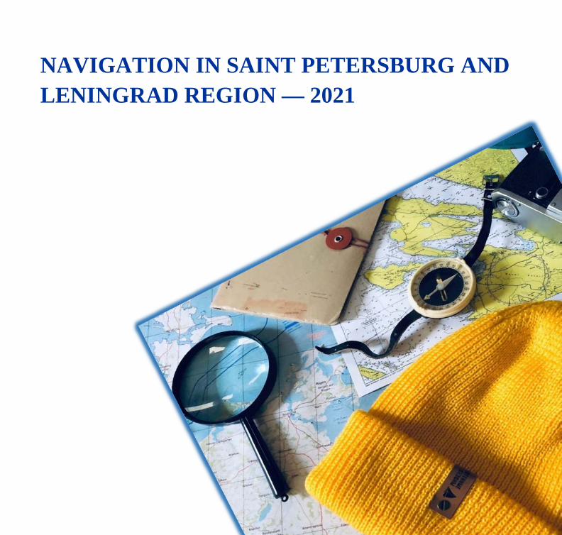
NAVIGATION IN SAINT PETERSBURG AND LENINGRAD REGION — 2021
CONTENTS
TOURIST ROUTES ON WATERWAYS IN NORTH-WEST RUSSIA 3 THE VYBORG ROUTE 4 THE NOVGOROD ROUTE 13 THE SAIMAA ROUTE 22 THE SEVERNY ROUTE 29
YACHT CLUBS AND GUEST BERTHS (SAINT PETERSBURG, LENINGRAD OBLAST, REPUBLIC OF FINLAND) 35
SPECIFICS OF NAVIGATION ON INLAND WATERS OF THE RUSSIAN FEDERATION FOR SPORT SAILBOATS AND PLEASURE CRAFT 37
SPECIFICS OF BORDER AND CUSTOMS CONTROL AT RUSSIAN FEDERATION STATE BORDER CHECKPOINTS IN THE TERRITORY OF SAINT PETERSBURG AND LENINGRAD OBLAST BRUSNICHNOYE CHECKPOINT (SAIMAA CANAL), FORT CONSTANTINE CHECKPOINT 40
SPECIFICS OF NAVIGATION IN CERTAIN AREAS OF WATERWAYS 41 BORDER AREA 41 SAIMAA CANAL 42 VYBORG BAY 43 CERTAIN WATER BODIES OF SAINT PETERSBURG 44
PROCEDURE FOR ENTRY OF VESSELS TO THE SEA PORTS BIG PORT OF SAINT PETERSBURG AND PASSENGER PORT OF SAINT PETERSBURG 45
USEFUL INFORMATION 46

TOURIST ROUTES ON WATERWAYS IN NORTH-WEST RUSSIA
The Vyborg route: Saint Petersburg — Kronstadt — Primorsk — Vysotsk — Vyborg.
The Novgorod route: Saint Petersburg — Shlisselburg — Staraya Ladoga — Kirishi — Veliky Novgorod.
The Saimaa route: Kronstadt — Vyborg — Lappeenranta — Imatra — Puumala — Savonlinna.
The Severny route: Kronstadt — Saint Petersburg — Shlisselburg — Konevets — Valaam — Sortavala — Svir River — Voznesenye — Petrozavodsk — Kizhi — Medvezhyegorsk — Belomorsk — Solovetsky Islands — Arkhangelsk — Kirkenes.

The Vyborg route A direct route between Saint Petersburg and Vyborg, two major Russian ports in the Gulf of
Finland, with a visit to Kronstadt, a city of naval glory and smaller but not less interesting towns of Primorsk and Vysotsk, which are also important ports in the Baltic Sea. The total length of the route is about 170 km.
Vyborg
Vysotsk
Primorsk
Kronstadt
Saint Petersburg
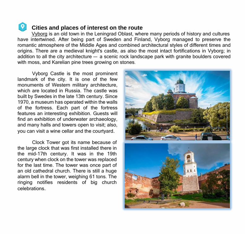
Cities and places of interest on the route Vyborg is an old town in the Leningrad Oblast, where many periods of history and cultures
have intertwined. After being part of Sweden and Finland, Vyborg managed to preserve the romantic atmosphere of the Middle Ages and combined architectural styles of different times and origins. There are a medieval knight's castle, as also the most intact fortifications in Vyborg; in addition to all the city architecture — a scenic rock landscape park with granite boulders covered with moss, and Karelian pine trees growing on stones.
Vyborg Castle is the most prominent
landmark of the city. It is one of the few monuments of Western military architecture, which are located in Russia. The castle was built by Swedes in the late 13th century. Since 1970, a museum has operated within the walls of the fortress. Each part of the fortress features an interesting exhibition. Guests will find an exhibition of underwater archaeology, and many halls and towers open to visit; also, you can visit a wine cellar and the courtyard.
Clock Tower got its name because of the large clock that was first installed there in the mid-17th century. It was in the 19th century when clock on the tower was replaced for the last time. The tower was once part of an old cathedral church. There is still a huge alarm bell in the tower, weighing 61 tons. The ringing notifies residents of big church celebrations.

Annenkrone fortification was constructed in Vyborg in the early 18th century. It was necessary to defend against a likely attack of Swedish troops. A part of the fortress, bastions, moat and earth ramparts have been preserved. You may be curious to look at fortifications that were initially designed by Peter the Great. Every year, medieval jousting is reenacted there, with visitors coming from the whole Leningrad Oblast.
The old Town Hall is in the very center
of the main town square. In the 17th century, burgomasters were sitting there, and meetings of boards of trade, justice, finance, construction were held. During the WWII, the building was destroyed and suffered from fire, but in the 20th century, it was restored and distributed for residential use as apartments. Now the Town Hall is on the list of heritage sites, but people still live there.
Round Tower, the so-called Fat Ekaterina, is one of the few surviving monuments of old Vyborg; it was built in the mid-16th century during the time of the King of Sweden Gustav Vasa, when Vyborg stone fortifications built in the 1470s partially lost their defensive qualities and required reinforcement.
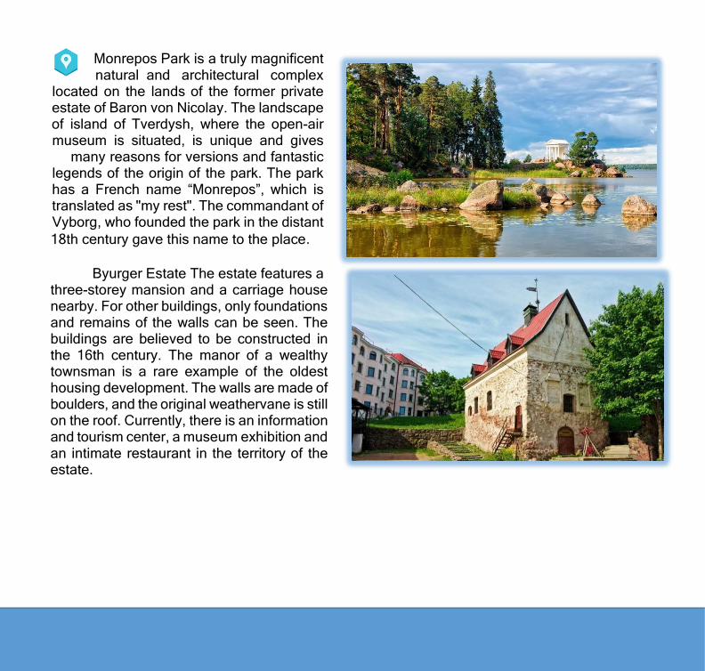
Monrepos Park is a truly magnificent natural and architectural complex
located on the lands of the former private estate of Baron von Nicolay. The landscape of island of Tverdysh, where the open-air museum is situated, is unique and gives
many reasons for versions and fantastic legends of the origin of the park. The park has a French name “Monrepos”, which is translated as "my rest". The commandant of Vyborg, who founded the park in the distant 18th century gave this name to the place.
Byurger Estate The estate features a
three-storey mansion and a carriage house nearby. For other buildings, only foundations and remains of the walls can be seen. The buildings are believed to be constructed in the 16th century. The manor of a wealthy townsman is a rare example of the oldest housing development. The walls are made of boulders, and the original weathervane is still on the roof. Currently, there is an information and tourism center, a museum exhibition and an intimate restaurant in the territory of the estate.

Vysotsk is one of the largest ports in the North West. The town itself is famous for magnificent views of the Vyborg Bay and historical monuments.
Trångsund Fortress was built on the instructions of Peter the Great on the Cape of the island of Uuransaari (the present island of Vysotsky) in the early 1860s. In plan view, the fortification was an irregular pentagon with earth ramparts and moats lined with granite blocks. Barracks, vaulted powder cellars, supply stores, gates, as well as a number of wooden buildings outside the walls were also built in the fortress in the 1880s. The fort continued to be of combat importance in the years of World War I.
The Niemel Battery of the Russian
Empire on the island of Rakosaari, which covered the entrance to the Niemel fairway was built in the 60s of the 19th century. On the island of pentagonal shape resembling a shield, 6-meter earth ramparts were raised, the shore was reinforced with stone, and gun positions and powder cellars were built. The largest and longest range new-style guns, 9- inch breech-loading rifled guns were installed in the main firing positions: the south and southwestern sides facing the fairway.

Primorsk is the largest Russian oil port in the Baltic Sea and at the same time a quiet town with beautiful seascapes and scenic nature.
Old Lutheran Church of Saint Mary Magdalene was designed by Josef Stenbäck in a Northern Art Nouveau style. One of the altar windows depicts the appearance of Jesus to Mary Magdalene. Several Russian movies were filmed there, including 'Peculiarities of the National Fishing'. On the Beryozovye islands (near Primorsk), Russian emperors Alexander III and Nicholas II who visited the church used to go fishing and hunting. Also, the first Soviet atomic icebreaker was tested there.
Monument to Mikael Agricola (Kyrönniemi cape) — the founder of Finnish writing and the founder of the Finnish literary language, the church reformer Mikael Agricola (1510-1557), is located 25 kilometers to Primorsk. The nature and the bay in this place are extraordinarily beautiful.
Zelenogorsk — 40 km
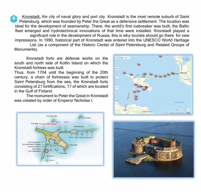
Fort Obruchev Fort Totleben
Fort 1 Fort 2 Fort Reef Fort Alexander Shanetz
Northern forts
Fort 3 Fort 4 Fort 5 Fort 6 Fort 7
Fort Constantine Fort Alexander I (Plague
Fort) Fort Peter I Fort Pavel I
Fort 3 (Milyutin)
Kronstadt
Kronshlot
Fort 2 Fort 1
Kronstadt, the city of naval glory and port city. Kronstadt is the most remote suburb of Saint Petersburg, which was founded by Peter the Great as a defensive settlement. The location was
ideal for the development of seamanship. There, the world's first icebreaker was built, the Baltic fleet emerged and hydrotechnical innovations of that time were installed. Kronstadt played a
significant role in the development of Russia, this is why tourists should go there for new impressions. In 1990, historical part of Kronstadt was entered into the UNESCO World Heritage
List (as a component of the Historic Center of Saint Petersburg and Related Groups of Monuments).
Kronstadt forts are defense works on the
south and north side of Kotlin Island on which the Kronstadt fortress was built. Thus, from 1704 until the beginning of the 20th century, a chain of fortresses was built to protect Saint Petersburg from the sea, the Kronstadt forts consisting of 21 fortifications, 17 of which are located in the Gulf of Finland.
The monument to Peter the Great in Kronstadt was created by order of Emperor Nicholas I.
Ring Road Ring Road Ring Road
Kronstadt

The monument was erected on a granite pedestal decorated with a bronze ornament at the corners. The monument was installed so that Peter the Great be facing the sea and the fortress of Kronshlot, from where the history of Kronstadt began. In the 60s of the 19th century, Petrovsky Park was developed around the monument.
Petrovsky Dock is one of the oldest hydraulic facilities in Kronstadt, the construction of which was begun by Peter the First. The dock could repair 10 large ships at the same time. As envisioned by the Emperor, ships requiring repairs would go from the Gulf of Finland to the dock, then the locks close, and the water flows by gravity into the pool dug below. From the pool, with the help of windmills and horse- drawn machines, water is pumped into the sea.
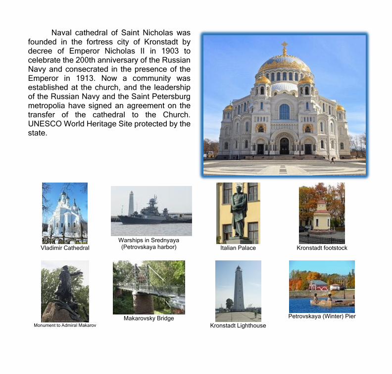
Naval cathedral of Saint Nicholas was founded in the fortress city of Kronstadt by decree of Emperor Nicholas II in 1903 to celebrate the 200th anniversary of the Russian Navy and consecrated in the presence of the Emperor in 1913. Now a community was established at the church, and the leadership of the Russian Navy and the Saint Petersburg metropolia have signed an agreement on the transfer of the cathedral to the Church. UNESCO World Heritage Site protected by the state.
Vladimir Cathedral
Warships in Srednyaya (Petrovskaya harbor)
Italian Palace
Kronstadt footstock
Monument to Admiral Makarov
Makarovsky Bridge
Kronstadt Lighthouse
Petrovskaya (Winter) Pier
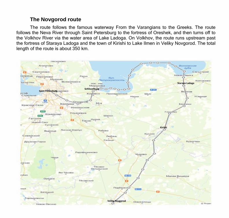
The Novgorod route The route follows the famous waterway From the Varangians to the Greeks. The route
follows the Neva River through Saint Petersburg to the fortress of Oreshek, and then turns off to the Volkhov River via the water area of Lake Ladoga. On Volkhov, the route runs upstream past the fortress of Staraya Ladoga and the town of Kirishi to Lake Ilmen in Veliky Novgorod. The total length of the route is about 350 km.
Staraya Ladoga
Saint Petersburg
Schlisselburg
Kirishi
Veliky Novgorod

Cities and places of interest on the route Saint Petersburg is the capital of white nights and drawbridges, and the largest center of the world's and Russian culture, known for its magnificent architectural ensembles, palaces,
museums. The worldwide reputation of Saint -Petersburg is based on its unique architecture,
monuments, museums and theaters — the State Hermitage Museum, State Russian Museum, Mariinsky Theatre, Philharmonic Hall, State University, as also palace and garden complexes of Peterhof, Pushkin, Pavlovsk.
UNESCO listed as a World Heritage Site the historic center of Saint- Petersburg, the system of ensembles of the main city space of Nevsky Prospekt, Liteynaya part, Admiralty part, Vasilyevsky Island, Petrograd side, islands, river Neva with its embankments and banks, palace and garden complexes in the outskirts — Pushkin, Pavlovsk, Gatchina, Peterhof, Strelna, Lomonosov, historical part of Kronstadt, Oreshek fortress, Pulkovo Astronomical Observatory and much more, over four thousand sites in total.
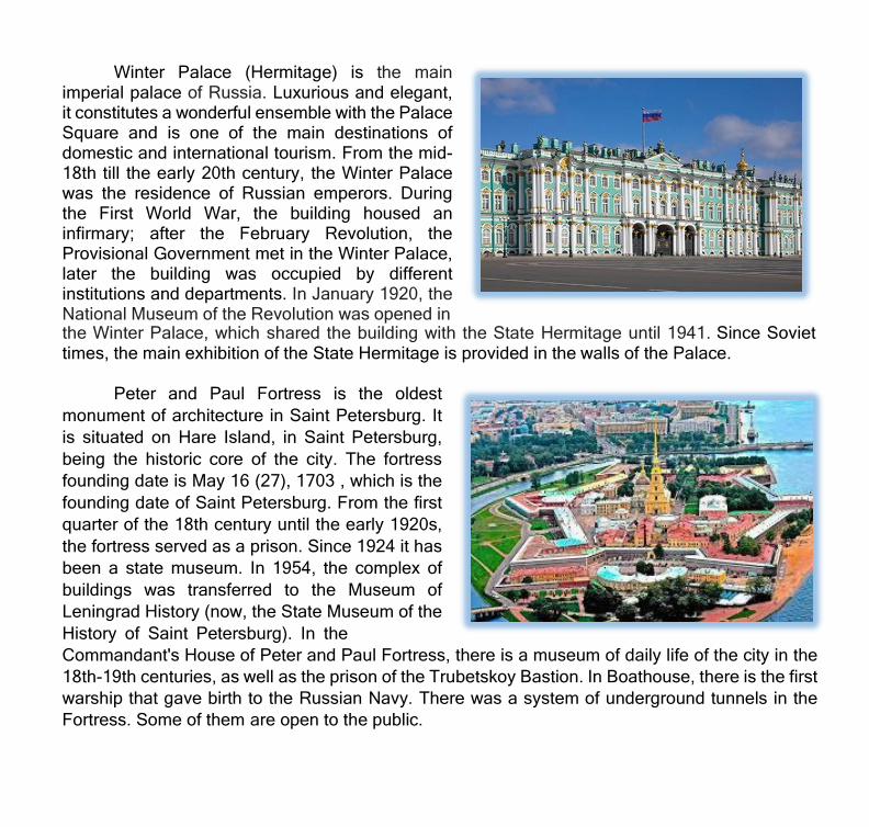
Winter Palace (Hermitage) is the main imperial palace of Russia. Luxurious and elegant, it constitutes a wonderful ensemble with the Palace Square and is one of the main destinations of domestic and international tourism. From the mid- 18th till the early 20th century, the Winter Palace was the residence of Russian emperors. During the First World War, the building housed an infirmary; after the February Revolution, the Provisional Government met in the Winter Palace, later the building was occupied by different institutions and departments. In January 1920, the National Museum of the Revolution was opened in the Winter Palace, which shared the building with the State Hermitage until 1941. Since Soviet times, the main exhibition of the State Hermitage is provided in the walls of the Palace.
Peter and Paul Fortress is the oldest
monument of architecture in Saint Petersburg. It is situated on Hare Island, in Saint Petersburg, being the historic core of the city. The fortress founding date is May 16 (27), 1703 , which is the founding date of Saint Petersburg. From the first quarter of the 18th century until the early 1920s, the fortress served as a prison. Since 1924 it has been a state museum. In 1954, the complex of buildings was transferred to the Museum of Leningrad History (now, the State Museum of the History of Saint Petersburg). In the Commandant's House of Peter and Paul Fortress, there is a museum of daily life of the city in the 18th-19th centuries, as well as the prison of the Trubetskoy Bastion. In Boathouse, there is the first warship that gave birth to the Russian Navy. There was a system of underground tunnels in the Fortress. Some of them are open to the public.
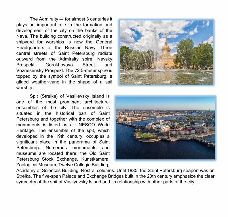
The Admiralty — for almost 3 centuries it plays an important role in the formation and development of the city on the banks of the Neva. The building constructed originally as a shipyard for warships is now the General Headquarters of the Russian Navy. Three central streets of Saint Petersburg radiate outward from the Admiralty spire: Nevsky Prospekt, Gorokhovaya Street and Voznesensky Prospekt. The 72.5-meter spire is topped by the symbol of Saint Petersburg, a gilded weather-vane in the shape of a sail warship.
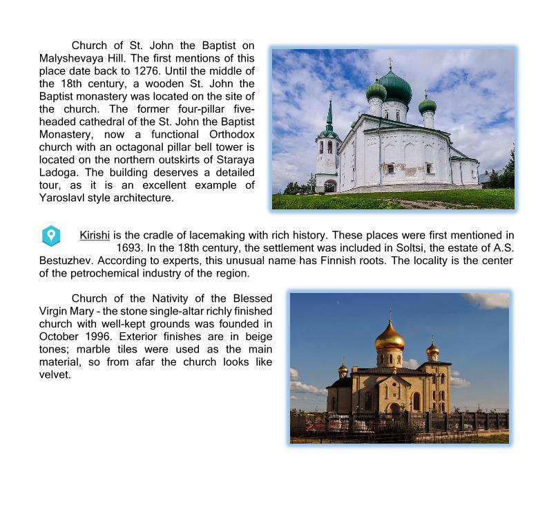
Spit (Strelka) of Vasilievsky Island is one of the most prominent architectural ensembles of the city. The ensemble is situated in the historical part of Saint Petersburg and together with the complex of monuments is listed as a UNESCO World Heritage. The ensemble of the spit, which developed in the 19th century, occupies a significant place in the panorama of Saint Petersburg. Numerous monuments and museums are located there: the Old Saint Petersburg Stock Exchange, Kunstkamera, Zoological Museum, Twelve Collegia Building, Academy of Sciences Building, Rostral columns. Until 1885, the Saint Petersburg seaport was on Strelka. The five-span Palace and Exchange Bridges built in the 20th century emphasize the clear symmetry of the spit of Vasilyevsky Island and its relationship with other parts of the city.

Iconic places of Saint Petersburg, history and culture
St. Isaac's Cathedral
Church of the Savior on Blood
Kazan Cathedral
Smolny Convent
Saint Alexander Nevsky Lavra
Trinity Cathedral
Pushkin Apartment Museum
The I. Repin Estate «The Penates»
Alexandrinsky Theater

Schlisselburg is the famous key-town at the head of Neva.
Oreshek Fortress is a unique architectural monument on the island of Orekhovy. The Fortress was built in 1323 by Grand Prince Yury Danilovich of Moscow, who was a grandson of Alexander Nevsky, for defense against the Swedes and was named after the island of Orekhovy, on which it is located. During the first three centuries, the Fortress was never captured, and during the World War II, it kept the defense for as many as 500 days, preventing the Germans from closing the ring of the siege of Leningrad.
Staraya Ladoga is the old capital of Northern Russia, “the first capital of Russia” that exists since the 8th century. It was there in 862 that Rurik came to reign. Many centuries ago, a village which is small now was a prosperous and developed city: a crossroads of trade routes, a craft center and an international trade port providing connections between the Slavs and European countries. Today, Staraya Ladoga is a unique complex of historical monuments united under the auspices of the Staraya Ladoga Historical, Architectural and Archeological Museum-Reserve.
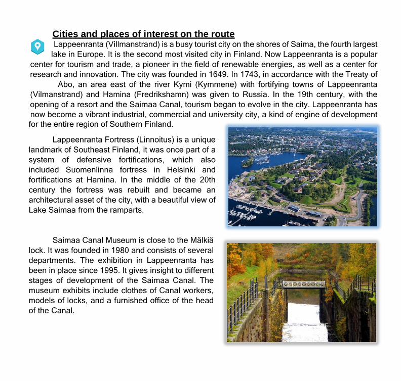
Church of St. John the Baptist on Malyshevaya Hill. The first mentions of this place date back to 1276. Until the middle of the 18th century, a wooden St. John the Baptist monastery was located on the site of the church. The former four-pillar five- headed cathedral of the St. John the Baptist Monastery, now a functional Orthodox church with an octagonal pillar bell tower is located on the northern outskirts of Staraya Ladoga. The building deserves a detailed tour, as it is an excellent example of Yaroslavl style architecture.
Kirishi is the cradle of lacemaking with rich history. These places were first mentioned in 1693. In the 18th century, the settlement was included in Soltsi, the estate of A.S.
Bestuzhev. According to experts, this unusual name has Finnish roots. The locality is the center of the petrochemical industry of the region.
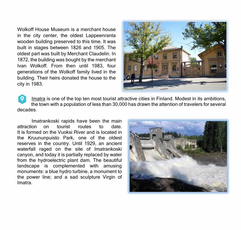
Church of the Nativity of the Blessed
Virgin Mary - the stone single-altar richly finished church with well-kept grounds was founded in October 1996. Exterior finishes are in beige tones; marble tiles were used as the main material, so from afar the church looks like velvet.

Kirishi Museum of History and Local Lore. The exhibition presents plenty of samples of Kirishi (Zakhozh) lace, and materials about the history of lacing and about the most famous craftswomen. The war section of the museum exhibits a large collection of trophies found on the site of the former German bridgehead, where the restoration of the pre-war village of Kirishi began in the early 1960s to turn it into a city in 1965. Among the captured weapons and equipment, there is also a shell-pierced church bell from one of the churches in the area that were completely destroyed during the World War II.
The Memorial to Destroyed Villages is located in the heart of Kirishi city and will definitely draw attention to its original design. As envisioned by the author of the monument, two hands hold a plate with the names of villages that disappeared off the face of the earth because of hostilities.

Veliky Novgorod is the place of origin of the Russian statehood. The Russia's
oldest city, a cradle of Russian democracy, a medieval center of trade and crafts, the largest partner of the Hanseatic League in 12th-17th centuries, the link between the medieval Europe and Russia, and the entrepôt on the border of two civilizations.
Novgorod Detinets is the fortress of Veliky Novgorod. Detinets is situated on the left bank of the Volkhov river. The first chronicled mention of the fortress dates back to 1044. It is a monument of architecture of federal importance and is protected by the state. Novgorod Detinets as part of the historical center of Veliky Novgorod is included in the UNESCO World Heritage List.
Cathedral of St. Sophia is one of the oldest temples of Russia, it was built on Novgorod land at the beginning of the 11th century and for hundreds of years was a spiritual center of the Novgorod Republic. The architecture of the temple is quite unique, its belltower in five bays constructed in the 15th century is of special interest.
Yaroslav's Court and Trade Mart is an
architectural complex situated on the Volkhov River bank opposite to the fortress. In its territory, there are monuments of 12-16 centuries, including St. Nicholas Cathedral founded in 1113.

The Saimaa Route The route runs past the fortresses of Kronstadt and Vyborg (Russia), via the Saimaa Canal
to Lake Saimaa. On Lake Saimaa, the route goes to two ports: Lappeenranta and Imatra (Finland). The total length of the route is about 340 km.
Savonlinna
Puumala
Оз. Сайма
Imarta
Lappeenranta
Vyborg
Primorsk
Gulf of Finland
Kronstadt
Cities and places of interest on the route Lappeenranta (Villmanstrand) is a busy tourist city on the shores of Saima, the fourth largest
lake in Europe. It is the second most visited city in Finland. Now Lappeenranta is a popular center for tourism and trade, a pioneer in the field of renewable energies, as well as a center for research and innovation. The city was founded in 1649. In 1743, in accordance with the Treaty of
Åbo, an area east of the river Kymi (Kymmene) with fortifying towns of Lappeenranta (Vilmanstrand) and Hamina (Fredrikshamn) was given to Russia. In the 19th century, with the opening of a resort and the Saimaa Canal, tourism began to evolve in the city. Lappeenranta has now become a vibrant industrial, commercial and university city, a kind of engine of development for the entire region of Southern Finland.
Lappeenranta Fortress (Linnoitus) is a unique landmark of Southeast Finland, it was once part of a system of defensive fortifications, which also included Suomenlinna fortress in Helsinki and fortifications at Hamina. In the middle of the 20th century the fortress was rebuilt and became an architectural asset of the city, with a beautiful view of Lake Saimaa from the ramparts.
Saimaa Canal Museum is close to the Mälkiä lock. It was founded in 1980 and consists of several departments. The exhibition in Lappeenranta has been in place since 1995. It gives insight to different stages of development of the Saimaa Canal. The museum exhibits include clothes of Canal workers, models of locks, and a furnished office of the head of the Canal.
Wolkoff House Museum is a merchant house in the city center, the oldest Lappeenranta wooden building preserved to this time. It was built in stages between 1826 and 1905. The oldest part was built by Merchant Claudelin. In 1872, the building was bought by the merchant Ivan Wolkoff. From then until 1983, four generations of the Wolkoff family lived in the building. Their heirs donated the house to the city in 1983.
Imatra is one of the top ten most tourist attractive cities in Finland. Modest in its ambitions, the town with a population of less than 30,000 has drawn the attention of travelers for several
decades.
Imatrankoski rapids have been the main attraction on tourist routes to date. It is formed on the Vuoksi River and is located in the Kruununpuisto Park, one of the oldest reserves in the country. Until 1929, an ancient waterfall raged on the site of Imatrankoski canyon, and today it is partially replaced by water from the hydroelectric plant dam. The beautiful landscape is complemented with amusing monuments: a blue hydro turbine, a monument to the power line; and a sad sculpture Virgin of Imatra.

The hotel Imatran Valtionhotelli is designed in 1902-1903 in the form of a medieval castle. It has a huge kitchen typical for medieval castles, a smoking salon with a fireplace, leather armchairs, guns and trophy skins on the walls, and even an in-house ghost — a mysterious lady in gray. Many crowned heads stayed in this hotel, including the family of the last Russian emperor and the current King of Sweden.
Church of the Three Crosses is dedicated to the three crosses of
Calvary
Imatran Kylpylä Spa a recreational compound
Nature Reserve a stone's throw from the center of Imatra

Puumala is considered a paradise for tourists. A few years ago Puumala was recognized as the most picturesque municipality in the Saimaa region, which was not surprising. The territory of the municipality includes more than 1,000 large and small islands, and the length
of the coastline here is 3,000 km. Sandy beaches and rocky shores covered with forest make landscape in this area unparalleled.
Puumalansalmi (bridge over the
Puumalansalmi Strait) is one of the largest bridges in Finland and the architectural landmark of Puumala. The panoramic elevator of the bridge takes you up, and you can fully enjoy a bird's-eye view of Saima and its shores. Before 1995, two shores of lake Saimaa in the town of Puumala were connected by ferry, but in 1995, a 781- meter bridge was built.
Port of Puumala. In summer, Puumala is a favorite meeting place for tourists and yachtmasters — lovers of water travel. To do this, the port of Puumala has all the necessary infrastructure to take in and maintain ships.
The Veera, Sylvi and Elsa berths are designed for mooring local vessels. Jallu, Norppa, Kippis and Nesto are guest berths.
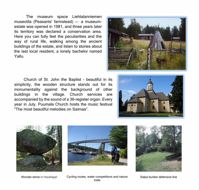
The museum space Liehtalanniemen museotila (Peasants' farmstead) — a museum- estate was opened in 1981, and three years later its territory was declared a conservation area. Here you can fully feel the peculiarities and the way of rural life, walking among the ancient buildings of the estate, and listen to stories about the last local resident, a lonely bachelor named Yallu.
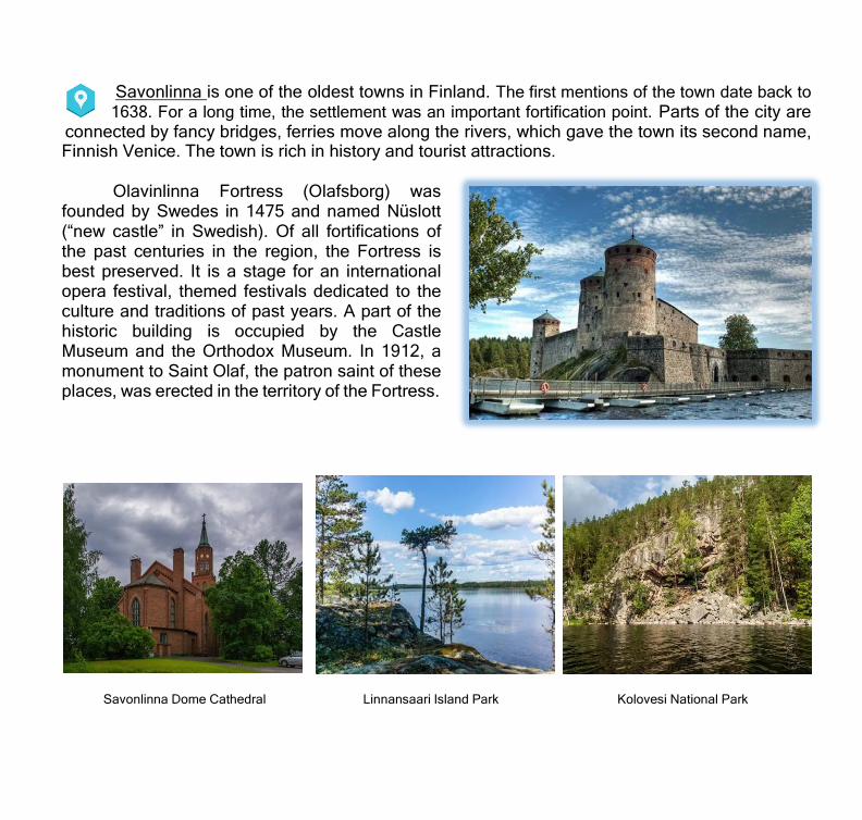
Church of St. John the Baptist - beautiful in its simplicity, the wooden structure stands out for its monumentality against the background of other buildings in the village. Church services are accompanied by the sound of a 36-register organ. Every year in July, Puumala Church hosts the music festival “The most beautiful melodies on Saimaa”.
Wonder stone in Hauklappi Cycling routes, water competitions and nature trails
Salpa bunker defensive line
Savonlinna is one of the oldest towns in Finland. The first mentions of the town date back to 1638. For a long time, the settlement was an important fortification point. Parts of the city are
connected by fancy bridges, ferries move along the rivers, which gave the town its second name, Finnish Venice. The town is rich in history and tourist attractions.
Olavinlinna Fortress (Olafsborg) was
founded by Swedes in 1475 and named Nüslott (“new castle” in Swedish). Of all fortifications of the past centuries in the region, the Fortress is best preserved. It is a stage for an international opera festival, themed festivals dedicated to the culture and traditions of past years. A part of the historic building is occupied by the Castle Museum and the Orthodox Museum. In 1912, a monument to Saint Olaf, the patron saint of these places, was erected in the territory of the Fortress.
Savonlinna Dome Cathedral Linnansaari Island Park Kolovesi National Park
The Severny route The route follows the Gulf of Finland, the Neva River to Schlisselburg via Lake Ladoga with
a visit to the islands of Konevets and Valaam further to Sortavala and Pellotsaari island and up the Svir River via Lake Onega to Petrozavodsk, Kizhi via the White Sea–Baltic Canal through the Solovetsky Islands to Arkhangelsk and on to Kirkenes (Norway). The total length of the route is about 2500 km.
The Severny route A part of the route passing through Saint Petersburg and Leningrad Oblast
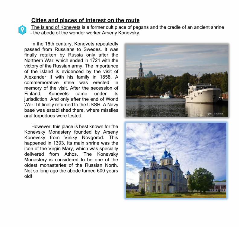
Cities and places of interest on the route The island of Konevets is a former cult place of pagans and the cradle of an ancient shrine - the abode of the wonder worker Arseny Konevsky.
In the 16th century, Konevets repeatedly passed from Russians to Swedes. It was finally retaken by Russia only after the Northern War, which ended in 1721 with the victory of the Russian army. The importance of the island is evidenced by the visit of Alexander II with his family in 1858. A commemorative stele was erected in memory of the visit. After the secession of Finland, Konevets came under its jurisdiction. And only after the end of World War II it finally returned to the USSR. A Navy base was established there, where missiles and torpedoes were tested.
However, this place is best known for the
Konevsky Monastery founded by Arseny Konevsky from Veliky Novgorod. This happened in 1393. Its main shrine was the icon of the Virgin Mary, which was specially delivered from Athos. The Konevsky Monastery is considered to be one of the oldest monasteries of the Russian North. Not so long ago the abode turned 600 years old!

Valaam Island, the largest of the 50 islands of the Valaam archipelago in Lake Ladoga, is
famous for the Valaam Monastery, the pearl of the Russian North and a Russian architecture monument, with several sketes spread across the island in addition to the main monastery court.
Valaam Monastery Gethsemane skete
Divny Island Saint Vladimir skete
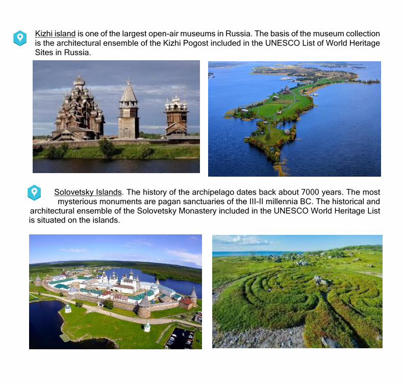
Kizhi island is one of the largest open-air museums in Russia. The basis of the museum collection is the architectural ensemble of the Kizhi Pogost included in the UNESCO List of World Heritage Sites in Russia.
Solovetsky Islands. The history of the archipelago dates back about 7000 years. The most mysterious monuments are pagan sanctuaries of the III-II millennia BC. The historical and
architectural ensemble of the Solovetsky Monastery included in the UNESCO World Heritage List is situated on the islands.

Arkhangelsk is one of the oldest cities in the north of the European Russia. Russian
Gateway to the Arctic. Today, Arkhangelsk is the cultural and historical capital of the Russian North. Many old buildings have been preserved in the city, museums operate, exhibitions and festivals are held every year. Tourists are brought there by
the opportunity to feel the spirit of Russian antiquity, learn ancient traditions, customs, cuisine, arts and crafts.
Malye Korely, an open-air museum of wooden architecture on the bank of the Northern Dvina
River.
The merchant court was built in the second
half of the 17th century.
Cape Pur-Navolok — place of origin of the city
Dormition Church of 1624 Museum of Art Development of the Arctic

Kirkenes is a small town located in the northeast of Northern Norway, near
the Russian border. Kirkenes is known as the capital of the Barents region and the gateway to the east.
One of the biggest landmarks in Kirkenes is Snowhotel, which is built anew every year. The hotel is open from December to April.
If you are fond of nature, you can visit the small Pasvik National Park in the vicinity of Kirkenes, as designed to preserve intact forests that are almost the last in the region and those plants that are typical for that location. In summer, you can go on picnics and camp out in a tent, and in winter - go skiing or sledding or participate in reindeer sledding races.
In addition to natural wealth, there are some interesting monuments in Kirkenes, as also temples and museums, including Jakobselv church, which is almost on the border Norway and Russia and is dedicated to the King Oscar II of Sweden and Norway.

WATER AREA: VYBORG BAY
Dubkovaya Bay yacht club
N60º14,055’ E28º59,728’ Okunevaya recreation center, Okuneviy proezd, 4
+7 (812) 928-08-68; +7(812)715-0500 Berth operator: +7 (931) 531-5750 www.dubkovaya.ru;
www.okunevaya.ru; [email protected]; [email protected]
Number of parking spaces: 80 • Boat slip (width 6 m), mooring area; • Electricity, water, wi-fi, laundry, showers, WC, banya, 24- hour security guards service; • Cottages, hotel, restaurant
Koivisto yacht
club
N60.365, E28.579 Primorsk, ul. Zavodskaya, 6
+7 (911) 119-02-87 www.koivisto-pro.ru; [email protected]
Number of parking spaces: 80 (15 for guests) • Flat railless slip (width 4,5 m), mooring area; • 24-hour security guards service, cottages
Johannes yacht
port
N60°31'29" E28°39'25" Sovetsky, ul. Sportivnaya, plots 1-5
+7 (911)923-73-30; +7 (911) 000-75-31 [email protected]
Number of parking spaces: 300 • Boat slip (8m), parking area; • wi-fi.
Favorit yacht club 60°41'48"N 28°44'15"E
Vyborg, Tsvetushchiy Mys, 1 (Bobovy Cape) +7(813)789-97-08; +7(950)012-94-82
+7(911)-71-222-02 к[email protected]; Parusa.vbg.ru
Number of parking spaces: 30 • Two boat slips of 6x15, 8x20, mooring area; • Electricity, water, WC, showers. • Mast lifting device;
WATER AREA: SAIMAA CANAL Lavola yacht club N60°46.33 E28°41.964
Rappatily, ul. Farvaternaya, 4 +7 (931) 210-38-32; +7 (911) 207-02-08
Number of parking spaces: 50 • Two boat slips (width 3m and 5m), parking area, • Electricity, water, wi-fi; laundry, banya, refueling, restaurant
WATER AREA: NEVA RIVER Sea Wolves yacht
club N59.831493 E30.943574
Dubrovka, ul. Sovetskaya, 1 +7 (812) 648-80-88; +7 (981) 810-05-00
Number of parking spaces: berth — 60, shore — 100 • Boat slip (width 4m), parking area; • Electricity, water, recreation areas.
WATER AREA: LADOGA LAKE Ladozhsky yacht
club N61º02,41’ E30º10,00,8’
Priozersk, ul. Zavodskaya, 1b Vuoksa River estuary +7 (921) 747 5794
[email protected]; klub-ladogskii.ru
Number of parking spaces: 80 • Boat slip (4x10m), parking area; • Solid and liquid waste reception, security guards.
Laguna yacht club N61°02' 35" E30°10' 22" Priozersk, ul. Zaozernaya
+7(921)966-10-85; +7(812)960-00-66 Lagunaladoga.ru
Number of parking spaces: 150 • Boat slip (width 6), parking area; • Refueling services, minor repairs, security guards.
YACHT CLUBS AND GUEST BERTHS (SAINT PETERSBURG, LENINGRAD OBLAST, REPUBLIC OF FINLAND)
Koshkinsky farwater yacht
club
N59.979343 E31.069424 Morozovskoye settlement,
Koshkino village, 17; +7(921)372-01-18 [email protected]; marinaladoga.ru
Number of parking spaces: 220 • Boat slip (5x15 m), parking area; • Restaurant, hotel, banya.
WATER AREA: BIG PORT OF SAINT PETERSBURG Fort Constantine
yacht club
Baltiyets yacht club
(services for yacht club members only)
N59.9948 E29.7049 Kronstadt, ul. Ilmyaninova 2
+7 812 382-08-88; +7 (921) 578-63-66 [email protected]; [email protected]
www.forthotel.ru
N59.8592 E30.1288 Petergofskoe shosse, 75 bldg 2
+7(921) 332-93-52 guest mooring - www.baltclub.com
Republic of Finland
Number of parking spaces: 130 • Boat slip (width 6 m), mooring area; • Water, electricity on berths, wi-fi, 24-hour security guards service.
• Provision of water, fuel, gas, food products; • Yacht lift and launch, maintenance and repairs.
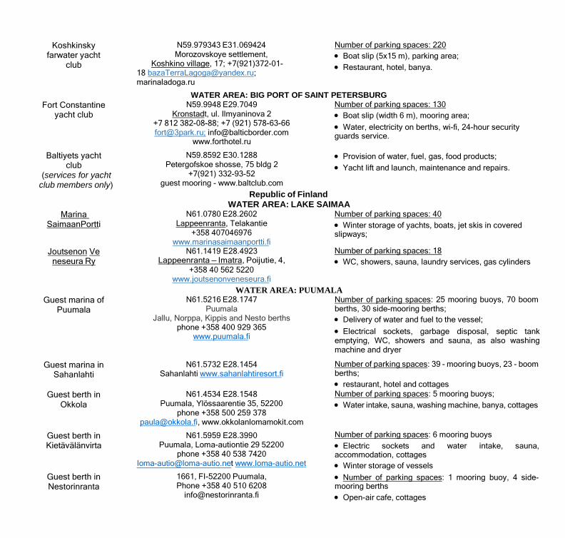
WATER AREA: LAKE SAIMAA Marina
Saimaan Portti
Joutsenon Veneseura Ry
N61.0780 E28.2602 Lappeenranta, Telakantie
+358 407046976 www.marinasaimaanportti.fi
N61.1419 E28.4923 Lappeenranta — Imatra, Poijutie, 4,
+358 40 562 5220 www.joutsenonveneseura.fi
Number of parking spaces: 40 • Winter storage of yachts, boats, jet skis in covered slipways;
Number of parking spaces: 18 • WC, showers, sauna, laundry services, gas cylinders
WATER AREA: PUUMALA Guest marina of
Puumala
Guest marina in Sahanlahti
Guest berth in
Okkola
Guest berth in Kietävälänvirta
Guest berth in Nestorinranta
N61.5216 E28.1747 Puumala
Jallu, Norppa, Kippis and Nesto berths phone +358 400 929 365
www.puumala.fi
N61.5732 E28.1454 Sahanlahti www.sahanlahtiresort.fi
N61.4534 E28.1548
Puumala, Ylössaarentie 35, 52200 phone +358 500 259 378
[email protected], www.okkolanlomamokit.com
N61.5959 E28.3990 Puumala, Loma-autiontie 29 52200
phone +358 40 538 7420 [email protected] www.loma-autio.net
1661, FI-52200 Puumala, Phone +358 40 510 6208
Number of parking spaces: 25 mooring buoys, 70 boom berths, 30 side-mooring berths; • Delivery of water and fuel to the vessel; • Electrical sockets, garbage disposal, septic tank emptying, WC, showers and sauna, as also washing machine and dryer
Number of parking spaces: 39 - mooring buoys, 23 - boom berths; • restaurant, hotel and cottages Number of parking spaces: 5 mooring buoys; • Water intake, sauna, washing machine, banya, cottages
Number of parking spaces: 6 mooring buoys • Electric sockets and water intake, sauna, accommodation, cottages • Winter storage of vessels • Number of parking spaces: 1 mooring buoy, 4 side- mooring berths • Open-air cafe, cottages
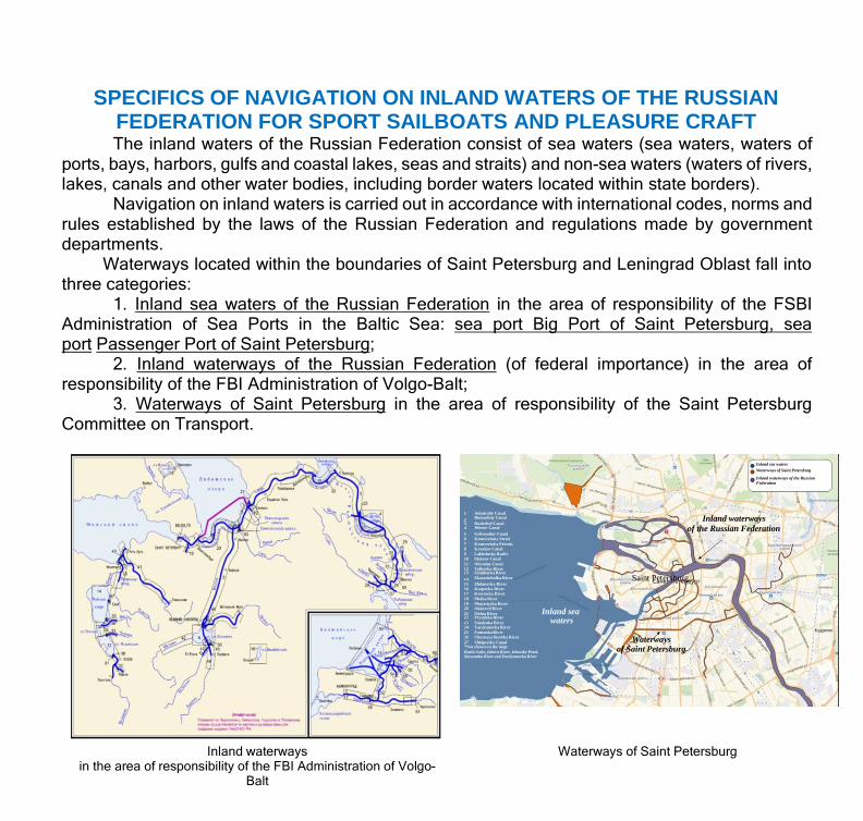
SPECIFICS OF NAVIGATION ON INLAND WATERS OF THE RUSSIAN FEDERATION FOR SPORT SAILBOATS AND PLEASURE CRAFT The inland waters of the Russian Federation consist of sea waters (sea waters, waters of
ports, bays, harbors, gulfs and coastal lakes, seas and straits) and non-sea waters (waters of rivers, lakes, canals and other water bodies, including border waters located within state borders).
Navigation on inland waters is carried out in accordance with international codes, norms and rules established by the laws of the Russian Federation and regulations made by government departments.
Waterways located within the boundaries of Saint Petersburg and Leningrad Oblast fall into three categories:
1. Inland sea waters of the Russian Federation in the area of responsibility of the FSBI Administration of Sea Ports in the Baltic Sea: sea port Big Port of Saint Petersburg, sea port Passenger Port of Saint Petersburg;
2. Inland waterways of the Russian Federation (of federal importance) in the area of responsibility of the FBI Administration of Volgo-Balt;
3. Waterways of Saint Petersburg in the area of responsibility of the Saint Petersburg Committee on Transport.
Inland sea waters Waterways of Saint Petersburg
Inland waterways of the Russian Federation
1 Admiralty Canal 2 Bumazhny Canal Inland waterways 3 Duderhof Canal 4 Winter Canal of the Russian Federation 5 Griboyedov Canal 6 Kronverksky Strait 7 Kronverksky Protok: 8 Kryukov Canal 9 Lakhtinsky Razliv 10 Matisov Canal 11 Obvodny Canal 12 Volkovka River 13 Glukharka River 14 Ekaterinhofka River Saint Petersburg 15 Zhdanovka River 16 Karpovka River 17 Krestovka River 18 Moika River 19 Monastyrka River 20 Okkervil River Inland sea 21 Okhta River 22 Pryazhka River waters 23 Smolenka River 24 Tarakanovka River 25 Fontanka River 26 Chornaya Rechka River Waterways 27 Shkipersky Canal *Not shown on the map: of Saint Petersburg Razliv Lake, Izhora River, Izhorsky Pond, Slavyanka River and Emelyanovka River
Inland waterways in the area of responsibility of the FBI Administration of Volgo-
Balt
Waterways of Saint Petersburg

Yachts sailing under foreign flag shall have the right to: - cross the border of the Russian Federation at established checkpoints (harbor checkpoints, the waters of which have access to inland waterways and river (lake) checkpoints, to be approved by the Ministry of Transport of Russia) along certain fairways specified in the “Notice to Mariners” and proceed through the water area
of the port along the established routes specified in the Mandatory Resolution of the harbor master:
vessels and persons on them undergo border,
customs, veterinary, quarantine phytosanitary, sanitary and quarantine control as also other types of control;
when passing border control, the boatmaster (owner of the vessel) shall provide information on
the planned voyage route with expected ports of call and indicative dates of call at these ports;
submit documents: • (certified copies) confirming the ownership of
the vessel; • confirming the type and purpose of the vessel,
the right to sail under the flag of the state of registry; • conformity of the vessel with established
international technical requirements or technical requirements of the state of registry;
• list of crew members (the crew list); • ship's log (logbook or unified logbook);
provide the vessel for inspection by the state control authorities (upon arrival of the vessel: border guard service, then customs authorities, upon departure - in
reverse order) and obtain marks on the passage of state control;
upon completion of border and customs control, the boatmaster shall inform the border guards of the
location of the small vessel (yacht club) and must notify the yacht club duty officer of his arrival, while Incoming foreign
small vessels should notify the border guards of their expected navigation areas;
upon arrival of a small vessel to the yacht club, the yacht club duty officers and the agent inform the duty
service of the border control unit;
upon departure of a small vessel to inland waters, inland sea waters, or navigational area in the border
zone, the boatmaster shall inform the duty service of the border control unit.
-navigate on the inland waterways of the Russian Federation (included in the list of inland
waterways of the Russian Federation for which sailing under flags of foreign states is permitted), and call at ports (open for vessels under flags of foreign states).
* More information on the rules of inland waterway navigation is contained in RF Government Decision No. 472 dated
12.05.2012 “On Approval of the Rules of Navigation for Sports Sailing Vessels and Leisure Craft Flying Foreign Flags through the Inland Waterways of the Russian Federation”.

Specifics of border and customs control at RF state border checkpoints in the territory of Saint Petersburg and Leningrad Oblast
Brusnichnoye checkpoint (Saimaa Canal)
This checkpoint is operating only during the period of navigation.
Lock No.1
Brusnichnoye - customs checkpoint (Vyborg sea port)
Lock No. 5 Pälli - border control (Federal Security Service Directorate of Russia for Saint Petersburg and Leningrad Oblast).
Arrival of a small vessel in the Russian Federation:
Lock No. 5 — Lock No. 1
Departure of small vessel from the territory of the Russian Federation:
Lock No. 1 — Lock No. 5
Passage is allowed through the Russian part of the Saimaa Canal and the inland waters and territorial sea of the Russian Federation, through the canals and fairways to the Gulf of Finland, for transit citizens of the Republic of Finland and citizens of third states traveling to/from the Republic of Finland on small vessels for personal use, not for commercial purposes.
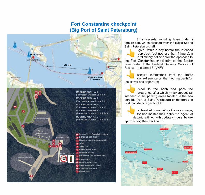
Fort Constantine checkpoint (Big Port of Saint Petersburg)
Kronstadt
Fort Constantine
MOORING AREA No. 5
Big Port of Saint Petersburg
MOORING AREA No. 1 (For vessels with draft up to 4 m)
MOORING AREA No. 2 (For vessels with draft up to 7 m)
MOORING AREA No. 3 (For vessels with draft up to 4 m)
MOORING AREA No. 4 (For vessels with draft up to 1.5 m)
MOORING AREA No. 5 (For vessels with draft up to 1.5 m)
Small vessels, including those under a foreign flag, which proceed from the Baltic Sea to Saint Petersburg shall:
give, within a day before the intended approach (but not less than 4 hours), a preliminary notice about the approach to
the Fort Constantine checkpoint to the Border Directorate of the Federal Security Service of Russia - to channel 6 (VHF);
receive instructions from the traffic control service on the mooring berth for
the arrival and departure;
moor to the berth and pass the clearance, after which it may proceed as
intended to the parking areas located in the sea port Big Port of Saint Petersburg or remoored in Fort Constantine yacht club
at least 24 hours before the sea voyage, the boatmaster shall notify the agent of
departure time, with update 4 hours before approaching the checkpoint.
MOORING AREA No. 2
MOORING AREA No. 4
MOORING AREA No. 3
MOORING AREA No. 1
Hotel, cafe, m/v Reeperbahn berthing
BORDER CHECKPOINT
Dispatcher control center, pass office
Helipad
Car parking
Weather station online
Launch/lift boat slip
Recreational area, barbeque area
Open-air cafe
Beach, volleyball court
Cable wakeboarding school
Trampoline, playground
Viewing platform
Specifics of navigation in certain areas of waterways
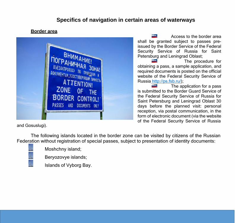
Border area
and Gosuslugi).
Access to the border area
shall be granted subject to passes pre- issued by the Border Service of the Federal Security Service of Russia for Saint Petersburg and Leningrad Oblast;
The procedure for obtaining a pass, a sample application, and required documents is posted on the official website of the Federal Security Service of Russia http://ps.fsb.ru/);
The application for a pass is submitted to the Border Guard Service of the Federal Security Service of Russia for Saint Petersburg and Leningrad Oblast 30 days before the planned visit: personal reception, via postal communication, in the form of electronic document (via the website of the Federal Security Service of Russia
The following islands located in the border zone can be visited by citizens of the Russian Federation without registration of special passes, subject to presentation of identity documents:
Moshchny island;
Beryozovye islands;
Islands of Vyborg Bay.

Finland Russia
Lake Saimaa
Vyborg Bay
km
Area leased by Finland from Russia
Saimaa Canal Determines the procedure and provides the terms for navigation on the Saimaa Canal:
Treaty between the Russian Federation and the Republic of Finland on lease of the Russian part of the Saimaa Canal and its adjacent territory by the Republic of Finland and on the navigation through Saimaa Canal (ratified by Federal Law No. 315-FZ dated 16.11.2011) (as amended on 20.04.2016);
Guideline for navigation of small vessels on the Saimaa Canal.
Locations of Saimaa Canal locks
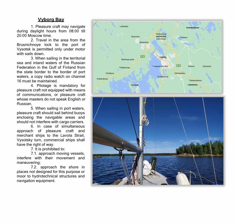
Vyborg Bay 1. Pleasure craft may navigate
during daylight hours from 08:00 till 20:00 Moscow time.
2. Travel in the area from the Brusnichnoye lock to the port of Vysotsk is permitted only under motor with sails down.
3. When sailing in the territorial sea and inland waters of the Russian Federation in the Gulf of Finland from the state border to the border of port waters, a copy radio watch on channel 16 must be maintained.
4. Pilotage is mandatory for pleasure craft not equipped with means of communications, or pleasure craft whose masters do not speak English or Russian.
5. When sailing in port waters, pleasure craft should sail behind buoys enclosing the navigable areas and should not interfere with cargo carriers.
6. In case of simultaneous approach of pleasure craft and merchant ships to the Lavola Strait, Vysotsky turn, commercial ships shall have the right of way.
7. It is prohibited to: 7.1. approach moving vessels,
interfere with their movement and maneuvering;
7.2. approach the shore in places not designed for this purpose or moor to hydrotechnical structures and navigation equipment.
Luzhayka Gvardeyskoye
Kravcovo Horticultural partnership Limonnoye
Paltsevo
Selesnevo
Vyborg Bolshoye pole
Podborovye Tsvetushchiy Mys Perovo Osinovka
Chulkovo Cherkasovo
Sokolinskoe Kubenskoye
Tolokonnikovo
Vysotsk Lebedevka

Certain water bodies of Saint Petersburg Navigation is provided in accordance with Saint Petersburg Government Decision No. 1165 dated
18.09.2007 “On Approval of the Rules of Use of Water Bodies for Navigation on Small Vessels in Saint Petersburg”.
The speed of movement of small vessels on certain water bodies of Saint Petersburg should not exceed 8 km/h, and when passing anchored floating docks and/or moored vessels and engineering ships - 5 km/h.
Small vessels shall use only navigable bridge spans marked by appropriate indicators of axis of the navigable channel.
Navigation in the area of Malaya Nevka River from Kamennoostrovsky Bridge to Leontievsky Cape on weekdays from 09:00 till 12:00 and from 16:00 till 19:00, on weekends and public holidays from 09:00 till 13:00 is prohibited.
Direction of movement of vessels on certain water bodies of Saint Petersburg

Procedure for entry of vessels to the sea ports Big Port of Saint Petersburg and Passenger Port of Saint Petersburg
Obtain written permission to navigate in the sea port
area and outside the sea port with return to the sea port:
• submit an application ([email protected]) to the harbor master: specify: the vessel's side number; the proposed area of navigation; contact details of the applicant, enclose: a copy of the vessel's certificate, a copy of the license to operate the small vessel, pleasure craft or sport sailboat.
• obtain a permission document at the address: Saint Petersburg, ul. Gapsalskaya, 10 at the time agreed.
• notify the harbor master during each exit/entry to/from the sea port

Useful information 1. Rules of Navigation for Sports Sailing Vessels and Leisure Craft Flying Foreign Flags through
the Inland Waterways of the Russian Federation (RF Government Decision No. 472 dated 12.05.2012; 2. Russian Federation state border checkpoints (https://mintrans.gov.ru/activities); 3. Diagram of the RF state border checkpoint for small vessels in the Sea Port Big Port of Saint
Petersburg http://balticborder.com/ru/border-control-point/; 4. The list of ports open for entry of ships under flags of foreign states and the list of RF inland
waterways where ships under flags of foreign states may sail (RF Government Decree No. 734-р dated 05.05.2012; 5. Guideline for navigation of small vessels on the Saimaa Canal; 6. Procedure for the passage of yachts and small boats within the waterways of the FBI Administration
of Volgo-Balt, rates of fees for passage and parking of yachts and small boats under the Russian flag and flags of foreign countries, pilot services, contract form, application forms and contact phone numbers can be found on the website www.volgo-balt.ru under “Passage of yachts”.
7. Guidelines for owners and boatmasters of small vessels, sport sailboats and pleasure craft, defining the procedure for entry to the waters of the sea ports Big Port of Saint Petersburg and Passenger Port of Saint Petersburg and the rules of stay in them https://78.mchs.gov.ru/);
8. North Western Customs Directorate website http://sztu.customs.ru; 9. Website of the Border Guard Service of the FSS of the Russian Federation http://ps.fsb.ru/ . When
approaching the Fort Constantine checkpoint, communication with the Border Service is maintained on Channel 6 (VHF), call signal “Granit”, e-mail address [email protected];
10. Information required for navigation on the waterways of Saint Petersburg is published on a regular basis on the website of the Saint Petersburg state public institution Agency for External Transport www.avt.spb.ru;
11. Official information (daily bulletin of parking and traffic of ships, daily schedule of ship traffic requests, passenger schedule) is posted in the Operational Information section on the website of the FSBI Administration of Sea Ports in the Baltic Sea at www.pasp.ru, see tab Sea Ports Activities - Sea Port Big Port of Saint Petersburg - Information.
12. Communication channel for notification of the harbor master is the VHF 9, call signal “Radio-5" (the alternative method of communication: at +7 (812) 245-16-77 and +7 (812) 714-92-11).
13. The updated “Notices to Mariners” are published on the website of the Directorate for Navigation & Oceanography of the RF Ministry of Defense https://structure.mil.ru.
14. Online service for booking guest berths: www.Book-marina.com. 15. Search for hotels, cafes, restaurants, with online booking:
www.tripadvisor.ru, www.tomesto.ru/, www.peterburg2.ru/, www.tourprom.r, www.booking.com, www.101hotels.ru