Embed Size (px)
Citation preview
317
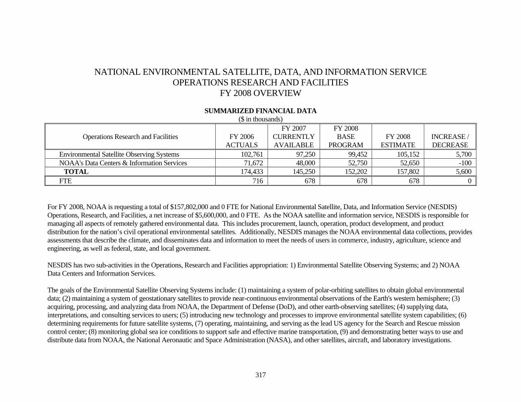
NATIONAL ENVIRONMENTAL SATELLITE, DATA, AND INFORMATION SERVICE OPERATIONS RESEARCH AND FACILITIES
FY 2008 OVERVIEW
SUMMARIZED FINANCIAL DATA ($ in thousands)
Operations Research and Facilities FY 2006
ACTUALS
FY 2007 CURRENTLY AVAILABLE
FY 2008 BASE
PROGRAM FY 2008
ESTIMATE INCREASE / DECREASE
Environmental Satellite Observing Systems 102,761 97,250 99,452 105,152 5,700 NOAA's Data Centers & Information Services 71,672 48,000 52,750 52,650 -100
TOTAL 174,433 145,250 152,202 157,802 5,600 FTE 716 678 678 678 0
For FY 2008, NOAA is requesting a total of $157,802,000 and 0 FTE for National Environmental Satellite, Data, and Information Service (NESDIS) Operations, Research, and Facilities, a net increase of $5,600,000, and 0 FTE. As the NOAA satellite and information service, NESDIS is responsible for managing all aspects of remotely gathered environmental data. This includes procurement, launch, operation, product development, and product distribution for the nation’s civil operational environmental satellites. Additionally, NESDIS manages the NOAA environmental data collections, provides assessments that describe the climate, and disseminates data and information to meet the needs of users in commerce, industry, agriculture, science and engineering, as well as federal, state, and local government. NESDIS has two sub-activities in the Operations, Research and Facilities appropriation: 1) Environmental Satellite Observing Systems; and 2) NOAA Data Centers and Information Services. The goals of the Environmental Satellite Observing Systems include: (1) maintaining a system of polar-orbiting satellites to obtain global environmental data; (2) maintaining a system of geostationary satellites to provide near-continuous environmental observations of the Earth's western hemisphere; (3) acquiring, processing, and analyzing data from NOAA, the Department of Defense (DoD), and other earth-observing satellites; (4) supplying data, interpretations, and consulting services to users; (5) introducing new technology and processes to improve environmental satellite system capabilities; (6) determining requirements for future satellite systems, (7) operating, maintaining, and serving as the lead US agency for the Search and Rescue mission control center; (8) monitoring global sea ice conditions to support safe and effective marine transportation, (9) and demonstrating better ways to use and distribute data from NOAA, the National Aeronautic and Space Administration (NASA), and other satellites, aircraft, and laboratory investigations.
318
The Environmental Satellite Observing Systems sub-activity includes the following budget line items for FY 2008:
• Satellite Command and Control, including NOAA Satellite Operations Facility (NSOF) operations • Product Processing and Distribution • Product Development, Readiness, and Application • Commercial Remote Sensing Licensing and Enforcement The goal of the NOAA Data Centers & Information Services sub-activity is to provide worldwide environmental data and information products and services in the atmospheric, oceanographic, marine, solid earth, and solar-terrestrial sciences to meet the needs of users in commerce, industry, agriculture, science and engineering, the general public, and Federal, state, and local agencies. Environmental data and information maintained by NOAA are vital to every economic sector and are used in making decisions critical to; national defense; industrial productivity; energy development and distribution; management and planning of water resources; world food supplies; public health, safety, and welfare; and development of natural resources. Environmental scientists and observers also have a critical need for a long time-series of historical and recent global data to assess long-term environmental trends, to evaluate the current state of the environment, and to predict future environmental conditions and events. In FY 2008, the NOAA Data Centers and Information Services sub-activity consists of the following budget line items:
• Archive, Access, and Assessment • Coastal Data Development • Regional Climate Centers • Environmental Data Systems Modernization NESDIS’ activities support all four Mission Goals in the NOAA Strategic Plan: Protect, Restore, and Manage The Use of Coastal and Ocean Resources through an Ecosystem Approach to Management; Understand Climate Variability and Change To Enhance Society’s Ability To Plan and Respond; Serve Society’s Needs For Weather and Water Information; and Support The Nation’s Commerce With Information For Safe, Efficient, and Environmentally Sound Transportation. Activities also support NOAA’s Mission Support Goal to Provide Critical Support for NOAA’s Mission. Research and Development Investments The NOAA FY 2008 Budget estimates for its activities, including research and development programs, are the result of an integrated, requirements-based Planning, Programming, Budgeting, and Execution System (PPBES) that provides the structure to link NOAA’s strategic vision with programmatic detail, budget development, and the framework to maximize resources while optimizing capabilities. The PPBES process incorporates the President’s Management Agenda and the Office of Science and Technology Policy’s Research and Development Investment Criteria (relevance, quality, and performance) for NOAA’s R&D programs, and leads to NOAA budget proposals that reflect the R&D investment criteria.
319
Significant Adjustments-to-Base (ATBs): NOAA requests an increase of 0 FTE and $2,623,000 to fund adjustments for NESDIS activities. Within this increase, program totals will fund inflationary adjustments for labor and non-labor.
320
THIS PAGE INTENTIONALLY LEFT BLANK
321
Subactivity: Environmental Satellite Observing Systems Line Item: Satellite Command and Control
GOAL STATEMENT: The goal of the Satellite Command and Control program is to provide efficient and secure command and control of NOAA and Department of Defense (DoD) operational environmental satellites to ensure timely and uninterrupted delivery of data to users. BASE DESCRIPTION: The Nation requires an environmental satellite system capable of providing timely and accurate environmental data. Early warning of major weather events saves countless lives and prevents substantial property damage. Billions of dollars in damage and hundreds of lives are lost each year due to natural disasters. These losses would be significantly worse if NOAA satellite data and services were unavailable due to interference with, or the failure of, critical satellite command and data acquisition infrastructure. The NOAA Satellite Command and Control program forms the backbone of the ground systems that command, control, and acquire data from on-orbit satellites with an estimated value of $4.5 billion on 24 hours per day, 365 days per year basis. The Satellite Command and Control program monitors satellite health and safety; schedules satellite operations and data acquisition to meet user needs; evaluates satellite systems performance; commands spacecraft; supports the National Aeronautics and Space Administration (NASA) during launch, activation, and evaluation of new satellites; and assesses satellite and ground station anomalies. The Satellite Command and Control program provides the day-to-day operations of the NOAA Satellite Operations Control Center in Suitland, Maryland, and satellite command and data acquisition stations in Wallops, Virginia, and Fairbanks, Alaska. From these ground stations, NOAA operates and acquires data from Polar-orbiting Operational Environmental Satellites (POES), Geostationary Operational Environmental Satellites (GOES), and DoD Meteorological Satellite Program (DMSP). Data from other non-NOAA operational and research satellites are also received to support specific NOAA missions. The NOAA Satellite Command and Control program ensures acquisition and near real-time delivery of satellite data to product processing centers that, in turn, support NOAA’s National Weather Service mission to protect lives and property during severe weather events. Base activities support Objective 3.5 “Provide Critical Support for NOAA’s Mission” under the Department of Commerce Strategic Goal of "Observe, Protect, and Manage the Earth’s Resources to Promote Environmental Stewardship". PROPOSED LEGISLATION: None.
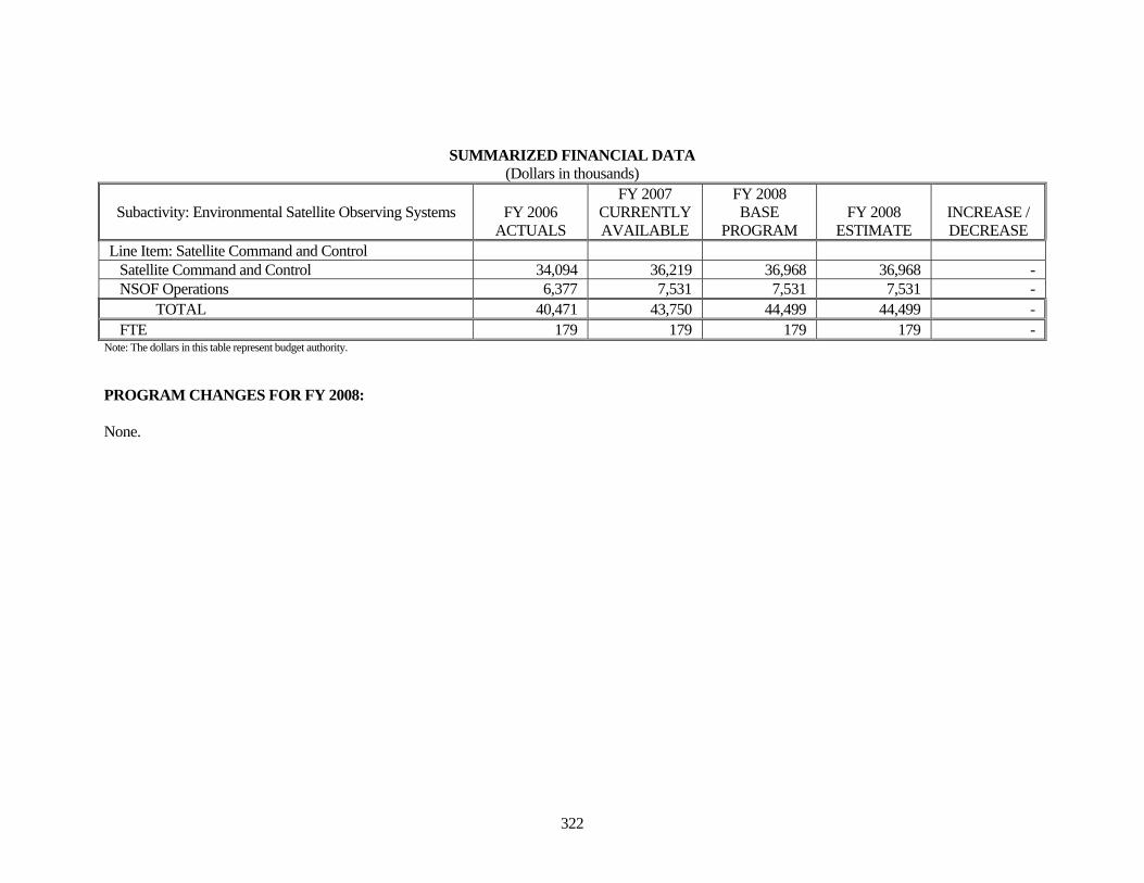
322
SUMMARIZED FINANCIAL DATA (Dollars in thousands)
Subactivity: Environmental Satellite Observing Systems FY 2006 ACTUALS
FY 2007 CURRENTLY AVAILABLE
FY 2008 BASE
PROGRAM FY 2008
ESTIMATE INCREASE / DECREASE
Line Item: Satellite Command and Control Satellite Command and Control 34,094 36,219 36,968 36,968 - NSOF Operations 6,377 7,531 7,531 7,531 - TOTAL 40,471 43,750 44,499 44,499 - FTE 179 179 179 179 -
Note: The dollars in this table represent budget authority. PROGRAM CHANGES FOR FY 2008: None.
323
Subactivity: Environmental Satellite Observing Systems Line Item: Product Processing and Distribution
GOAL STATEMENT: The Product Processing and Distribution (PP&D) program provides the Nation with specialized expertise and computing systems that ingest, process, analyze and distribute satellite-derived products and services that protect U.S. lives and property while enhancing the Nation’s environmental, national, homeland, and economic security. PP&D ingests data from Earth-observing satellites to provide the highest quality products and services to its users. BASE DESCRIPTION: PP&D provides satellite-derived products and services using data from NOAA, the Department of Defense, and NASA environmental satellites, as well as foreign and commercial spacecraft, to national and international customers and users on a 24 hours-per-day, 7 days-per-week basis. PP&D products enable NOAA to accurately track the location, extent and duration of severe weather such as hurricanes, tornadoes, and winter storms; support development of flash flood warnings; track volcanic ash clouds and severe winds that threaten aviation safety; detect remote wildland fires; monitor coastal ecosystem health; identify and monitor maritime hazards from sea ice; and assist in search and rescue activities. PP&D is the operational interface with NOAA’s National Weather Service and supplies the satellite data that makes up more than 99 percent of the information used in numerical weather prediction models. PP&D provides approximately 450 operational products organized into three categories: Atmospheric, Oceanographic, and Terrestrial. The PP&D program is constantly assessing and using data from advanced satellite sensors to improve operational support to its customers. It also supports activities to improve the effectiveness and interoperability of national systems for sharing natural disaster information. By using maps and data generated by remote- and land-based sensors, this information is made widely accessible to all government agencies and other entities involved in managing and mitigating the impacts of disasters. PP&D products are widely used by all branches of the U.S. Armed Services and the Department of Homeland Security. Included in the PP&D operations is NOAA’s contribution to the joint National Ice Center, which monitors global sea ice conditions to support safe and effective maritime transportation in the Polar Regions, Great Lakes, and Arctic and North Atlantic waters. This service is critical to National Weather Service warnings in ice-prone sea lanes, U.S. Coast Guard rescue attempts, and civilian and military shipping communities. PP&D provides NOAA’s contribution to the operations of the U.S. mission control center for satellite-assisted search and rescue program (SARSAT). Since SARSAT's inception, more than 18,500 people have been saved worldwide. In 2003, NOAA expanded the SARSAT program to include the use of Global Positioning System (GPS) Personal Locator Beacons. This has greatly improved the SARSAT program’s ability to save lives faster than before. NOAA, the U.S. Navy and the U.S. Coast Guard jointly operate the U.S. National Ice Center (NIC). The NIC supports civil and military maritime communities by monitoring global sea ice conditions to support safe and effective marine transportation.
324
Satellites provide the basic capability to rapidly and accurately observe these events; however, unprocessed satellite data cannot be used directly by these or other critical applications without the around-the-clock PP&D operations. Base activities support Objectives 3.4 “Support the Nation’s Commerce with Information for Safe, Efficient, and Environmentally Sound Transportation” and 3.5 “Provide Critical Support for NOAA’s Mission” under the Department of Commerce Strategic Goal of "Observe, Protect, and Manage the Earth’s Resources to Promote Environmental Stewardship". PROPOSED LEGISLATION: None.
325
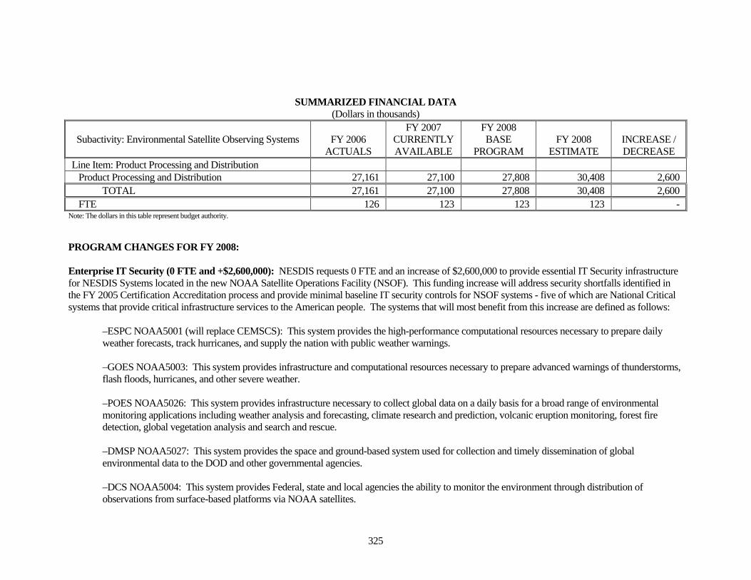
SUMMARIZED FINANCIAL DATA (Dollars in thousands)
Subactivity: Environmental Satellite Observing Systems FY 2006 ACTUALS
FY 2007 CURRENTLY AVAILABLE
FY 2008 BASE
PROGRAM FY 2008
ESTIMATE INCREASE / DECREASE
Line Item: Product Processing and Distribution Product Processing and Distribution 27,161 27,100 27,808 30,408 2,600 TOTAL 27,161 27,100 27,808 30,408 2,600 FTE 126 123 123 123 -
Note: The dollars in this table represent budget authority. PROGRAM CHANGES FOR FY 2008: Enterprise IT Security (0 FTE and +$2,600,000): NESDIS requests 0 FTE and an increase of $2,600,000 to provide essential IT Security infrastructure for NESDIS Systems located in the new NOAA Satellite Operations Facility (NSOF). This funding increase will address security shortfalls identified in the FY 2005 Certification Accreditation process and provide minimal baseline IT security controls for NSOF systems - five of which are National Critical systems that provide critical infrastructure services to the American people. The systems that will most benefit from this increase are defined as follows:
–ESPC NOAA5001 (will replace CEMSCS): This system provides the high-performance computational resources necessary to prepare daily weather forecasts, track hurricanes, and supply the nation with public weather warnings. –GOES NOAA5003: This system provides infrastructure and computational resources necessary to prepare advanced warnings of thunderstorms, flash floods, hurricanes, and other severe weather. –POES NOAA5026: This system provides infrastructure necessary to collect global data on a daily basis for a broad range of environmental monitoring applications including weather analysis and forecasting, climate research and prediction, volcanic eruption monitoring, forest fire detection, global vegetation analysis and search and rescue. –DMSP NOAA5027: This system provides the space and ground-based system used for collection and timely dissemination of global environmental data to the DOD and other governmental agencies. –DCS NOAA5004: This system provides Federal, state and local agencies the ability to monitor the environment through distribution of observations from surface-based platforms via NOAA satellites.
326
–SARSAT NOAA 5023: This system provides the operations and maintenance for the Search and Rescue Satellite Aided Tracking system (SARSAT). This includes the ground systems and local user terminal infrastructure necessary to relay signals from emergency beacons to federal search and rescue authorities. This system also serves as a backup (redundant) system capabilities for search and rescue activities in Australia, Japan and Canada.
This funding increase represents a down payment on NESDIS IT security infrastructure requirements that are a result of security requirements that were largely unrecognized until the institution of a markedly more rigorous Certification and Accreditation process in FY 2005. Since the original identification of this issue, requirements have continued to escalate and we believe that trend will continue for the foreseeable future. This funding request covers only the most critical of IT assets in the NESDIS portfolio, and is intended to fund the implementation of the National Institute of Standards and Technology (NIST) Federal Information Processing Standard (FIPS) 200 minimum required security controls. These security controls are mandated and can not be waived, making the implementation a non-discretionary action. NESDIS has diligently labored to improve its IT security program, but without additional funding, further improvements are not possible. NOAA’s future missions require enhanced capabilities to manage better and more secure information in support of the nine societal benefits established under the framework of the Global Earth Observation System of Systems (GEOSS). Adequately funded NSOF enterprise IT security will provide enduring solutions to high-risk problems and offer the potential to save millions of dollars, dramatically improve service to the American public, strengthen public confidence and trust in the performance and accountability of NOAA’s data and information. Statement of Need: All NOAA National Critical (High Impact), Mission Critical (Moderate Impact) and Business Essential (Low Impact) Systems must be in full compliance with the Federal Information Security Management Act (FISMA), Clinger Cohen Act, Office of Management and Budget (OMB) Circular A-130, Appendix III, Security of Federal Automated Information Resources, National Institute of Standards and Technology Publications/Guidance and Federal Information Processing Standards, and the Department of Commerce IT Security Policies. NESDIS has diligently labored to improve its IT security program. This funding addresses only the most critical requirements for a minimally acceptable IT security posture. The bulk of this funding will address particularly vexing problems in implementing legally mandated security controls in a legacy system environment, containing the majority of NOAA’s National Critical (High Impact) systems. In addition, these National Critical systems make up a major portion of DOC National Critical systems and correcting level II Security control inadequacies will have a major impact on the overall security posture of the Department. FY 2008 Proposed Actions: Funding will be used to hire contractor support for improving NSOF physical security, monitoring security controls, strengthening security program management and maintaining and enhancing critical infrastructure protection. Typical work activities will include ongoing configuration of systems (i.e. hardware and software), continuous update and maintenance of system security documentation (including system’s certification and accreditation
327
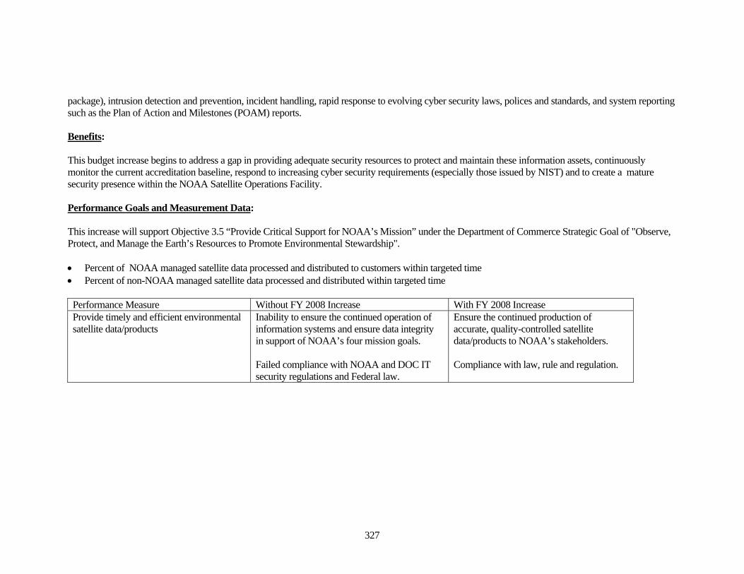
package), intrusion detection and prevention, incident handling, rapid response to evolving cyber security laws, polices and standards, and system reporting such as the Plan of Action and Milestones (POAM) reports. Benefits: This budget increase begins to address a gap in providing adequate security resources to protect and maintain these information assets, continuously monitor the current accreditation baseline, respond to increasing cyber security requirements (especially those issued by NIST) and to create a mature security presence within the NOAA Satellite Operations Facility. Performance Goals and Measurement Data: This increase will support Objective 3.5 “Provide Critical Support for NOAA’s Mission” under the Department of Commerce Strategic Goal of "Observe, Protect, and Manage the Earth’s Resources to Promote Environmental Stewardship". • Percent of NOAA managed satellite data processed and distributed to customers within targeted time • Percent of non-NOAA managed satellite data processed and distributed within targeted time
Performance Measure Without FY 2008 Increase With FY 2008 Increase Provide timely and efficient environmental satellite data/products
Inability to ensure the continued operation of information systems and ensure data integrity in support of NOAA’s four mission goals. Failed compliance with NOAA and DOC IT security regulations and Federal law.
Ensure the continued production of accurate, quality-controlled satellite data/products to NOAA’s stakeholders. Compliance with law, rule and regulation.
328
Subactivity: Environmental Satellite Observing Systems Line Item: Product Development, Readiness & Application
GOAL STATEMENT: The goal of the NOAA’s Product Development, Readiness, and Applications program (PDR&A) is to provide applications-focused research that will develop and evaluate prototype products, algorithms, and pre-operational products to improve existing operational satellite products and services using data from current and next generation environmental satellites. BASE DESCRIPTION: The Nation needs to enhance its use of satellite data to improve and extend weather forecasts, to expand environmental monitoring and assessment capabilities, and to provide new and improved tools for scientifically-based ecosystems management. In the next few years, the number and quality of satellite instruments will grow significantly, providing enhanced data capable of allowing major improvements in weather prediction accuracy. To make these improvements, targeted research and a cadre of scientists and computing systems dedicated to development is necessary. The PDR&A program ensures the highest accuracy of NOAA’s current satellite data and products via a robust and rigorous operational environmental satellite data calibration/validation program. This effort improves product quality for the benefit of all users. The program supports pre-operational development of products for weather, atmospheric, climate, land, wildland fire, and oceans and coastal applications. NOAA’s Ocean Remote Sensing Program supports sea surface temperature, ocean color, satellite altimetry, oceanic rainfall measurements, and coastal monitoring tools for the CoastWatch program. PDR&A supports a portion of the funding for the Joint Center for Satellite Data Assimilation (JCSDA), which accelerates the application of satellite data for improving weather forecast and other environmental models. The JCSDA was established to speed the development of new satellite data assimilation science. NOAA (NWS, OAR, and NESDIS), NASA and DoD are partners in this coordinated national effort to more fully realize the potential of the vast quantities of new satellite data that are becoming available. The JCSDA is also a risk reduction measure designed to accelerate NPOESS and GOES-R data utilization for the development of numerical weather prediction models, and forecast models that will lead to increased accuracy and longer-range forecasts. In the next few years, the number and quality of satellite instruments will grow significantly, providing an exponential increase in higher quality data capable of allowing major improvements in the accuracy of weather prediction. PDR&A also incorporates the latest academic findings into its work through competitively awarded Cooperative Institutes with academic institutions (Universities of Wisconsin, Maryland, Colorado State, and Oregon State, City College of New York). The academic expertise and the results of investigations are infused into product development, readiness, and applications that either lead to improvements in existing products or to the development of new products or sensors. Base activities support Objectives 3.1 “Protect, Restore, and Manage the Use of Coastal and Ocean Resources Through an Ecosystem Approach to Management”, 3.3 “Serve Society’s Need for Weather and Water Information”, and 3.5 “Provide Critical Support for NOAA’s Mission” under the Department of Commerce Strategic Goal of "Observe, Protect, and Manage the Earth’s Resources to Promote Environmental Stewardship".
329
PROPOSED LEGISLATION: None.
330
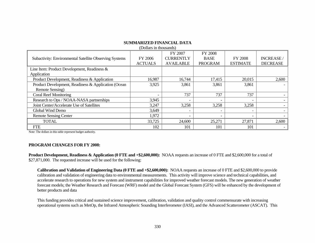
SUMMARIZED FINANCIAL DATA (Dollars in thousands)
Subactivity: Environmental Satellite Observing Systems FY 2006 ACTUALS
FY 2007 CURRENTLY AVAILABLE
FY 2008 BASE
PROGRAM FY 2008
ESTIMATE INCREASE / DECREASE
Line Item: Product Development, Readiness & Application
Product Development, Readiness & Application 16,987 16,744 17,415 20,015 2,600 Product Development, Readiness & Application (Ocean
Remote Sensing) 3,925 3,861 3,861 3,861 -
Coral Reef Monitoring - 737 737 737 - Research to Ops / NOAA-NASA partnerships 3,945 - - - - Joint Center/Accelerate Use of Satellites 3,247 3,258 3,258 3,258 - Global Wind Demo 3,649 - - - - Remote Sensing Center 1,972 - - - - TOTAL 33,725 24,600 25,271 27,871 2,600 FTE 102 101 101 101 -
Note: The dollars in this table represent budget authority. PROGRAM CHANGES FOR FY 2008: Product Development, Readiness & Application (0 FTE and +$2,600,000): NOAA requests an increase of 0 FTE and $2,600,000 for a total of $27,871,000. The requested increase will be used for the following:
Calibration and Validation of Engineering Data (0 FTE and +$2,600,000): NOAA requests an increase of 0 FTE and $2,600,000 to provide calibration and validation of engineering data to environmental measurements. This activity will improve science and technical capabilities, and accelerate research to operations for new system and instrument capabilities for improved weather forecast models. The new generation of weather forecast models; the Weather Research and Forecast (WRF) model and the Global Forecast System (GFS) will be enhanced by the development of better products and data This funding provides critical and sustained science improvement, calibration, validation and quality control commensurate with increasing operational systems such as MetOp, the Infrared Atmospheric Sounding Interferometer (IASI), and the Advanced Scatterometer (ASCAT). This
331
increase will provide for developing multidisciplinary multi-satellite products from new satellites/instruments to meet national needs for automated quality control, cascading product streams and product timeliness and instrument improvements to increase the usefulness of operational satellite data. Statement of Need: Without calibration and validation, satellite data will be unusable or degrade over time, resulting in reduced accuracy of NOAA’s operational forecasts, warnings and assessments. Additional funding is required to sustain and improve data and product accuracy requirements for new capabilities such as MetOp (IASI, ASCAT). Given the delays to NPOESS, MetOp will provide the only source of hyperspectral instrument coverage. This data is essential to assist with the mitigation efforts to bridge the potential gaps between the last POES satellite and the first NPOESS satellite. Without this data, we will be missing key drivers in long-range weather forecast models. We also need to address requirements for the NPOESS Preparatory Project (NPP), which will play an important role in NPOESS risk reduction and continuity of polar observations. Calibration for MetOp includes new technology (Infrared Atmospheric Sounding Interferometer or IASI) plus many of the POES heritage instruments. MetOp calibration and validation activities add to the workload while we maintain the POES mission flyouts. This is true because each instrument has its own unique characteristics and must be handled individually even though the instrument design may be exactly the same. In addition, the instruments are increasing in complexity and data rate. For example, the current operational sounder (High Resolution Infrared Radiation Sounder or HIRS) has 20 spectral wavelength bands and the key MetOp instrument (IASI) has 8000 spectral wavelength bands. This significant change in instrument capability and complexity adds to the workload of calibrating the instrument and validating the many products derived from the data. Cal/val is an ongoing activity for a given spacecraft and needs to be maintained until the instruments fail or the system is turned off. In addition, after the instrument has been deactivated, the satellite data is reanalyzed for climate applications to help meet climate requirements and specify climate trends. Without continuous cal/val the return on investment in all the products generated from these satellites will be significantly reduced. Without Cal/val, the sustained accuracy of weather forecasts and warnings cannot be maintained. This will put lives and property at risk through less accurate forecasts generated and distributed by NOAA and less accurate decisions by users. Ninety-nine percent of the data used in the National Weather Service prediction models comes from satellite data. FY 2008 Proposed Actions: FY 2008 funds will be used to provide contract support for calibration and validation of new data received from MetOp-A IASI and ASCAT, and NPP. Activities funded under the FY 2008 request will result in operational web sites with the latest calibration coefficients, tracking of data stream statistical properties, product validation on a daily and running average basis and other quantities that will make the data immediately useful for numerical weather prediction and other users. Benefits:
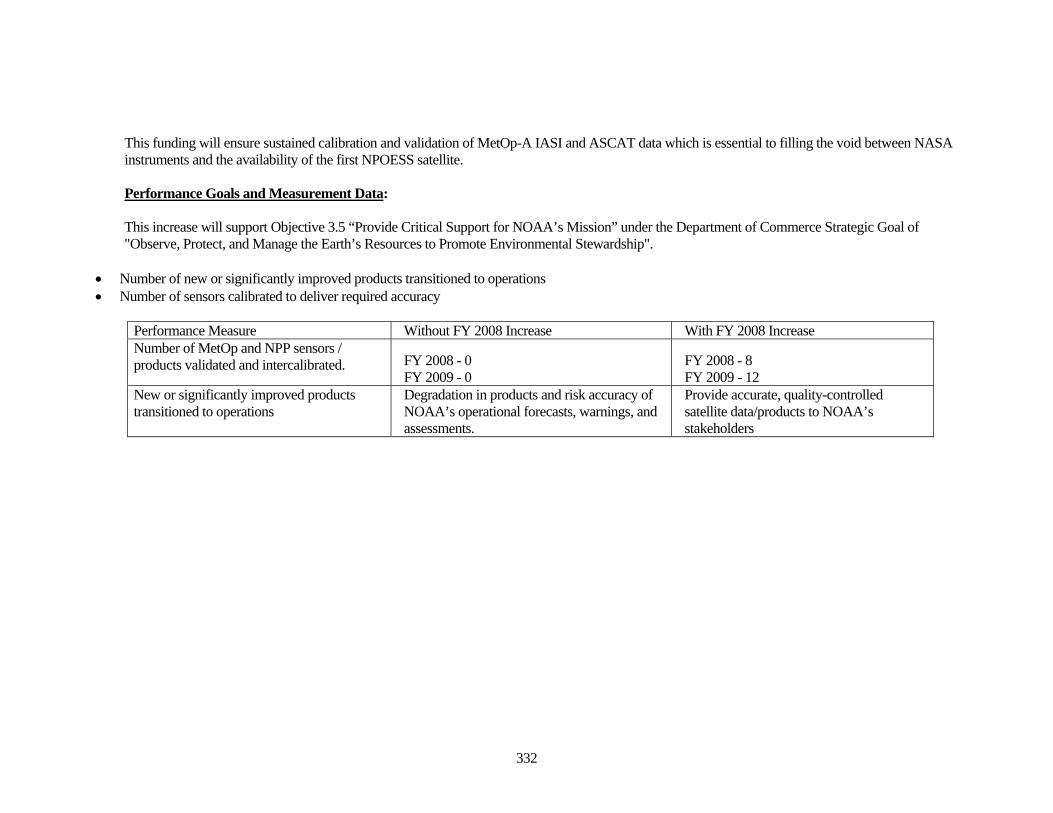
332
This funding will ensure sustained calibration and validation of MetOp-A IASI and ASCAT data which is essential to filling the void between NASA instruments and the availability of the first NPOESS satellite. Performance Goals and Measurement Data: This increase will support Objective 3.5 “Provide Critical Support for NOAA’s Mission” under the Department of Commerce Strategic Goal of "Observe, Protect, and Manage the Earth’s Resources to Promote Environmental Stewardship".
• Number of new or significantly improved products transitioned to operations • Number of sensors calibrated to deliver required accuracy
Performance Measure Without FY 2008 Increase With FY 2008 Increase Number of MetOp and NPP sensors / products validated and intercalibrated.
FY 2008 - 0 FY 2009 - 0
FY 2008 - 8 FY 2009 - 12
New or significantly improved products transitioned to operations
Degradation in products and risk accuracy of NOAA’s operational forecasts, warnings, and assessments.
Provide accurate, quality-controlled satellite data/products to NOAA’s stakeholders
333
Subactivity: Environmental Satellite Observing Systems Line Item: Office of Space Commercialization
GOAL STATEMENT: NOAA manages the Office of Space Commercialization (OSC) for the Department of Commerce. The Department of Commerce plays a key role in the development of U.S. Government policies that foster the growth and competitiveness of the U.S. commercial space industry. It serves as an advocate for the industry within interagency deliberations affecting the future of space, encouraging the promotion of commercial interests as well as national security, foreign policy, and other interests. NOAA supports the Department’s efforts to advance the development and implementation of the Administration’s new space sector policies for: commercial remote-sensing; Positioning, Navigation, and Timing (PNT); and space transportation. The National Space-Based PNT Executive Committee is a senior-level policy making body chaired jointly by the Departments of Defense and Transportation. Its membership includes the Departments of State, Commerce, Homeland Security, as well as NASA. The Department of Commerce committed to hosting the NPCO and through NOAA’s Office of Space Commercialization (OSC) and providing staff support to interagency PNT activities. BASE DESCRIPTION: Office of Space Commercialization The Office of Space Commercialization (OSC), managed by NOAA for the Department of Commerce, is responsible for developing space-related policies and promotion of the capabilities of the U.S. commercial space industry. OSC represents the Department of Commerce in negotiations with foreign countries to ensure free and fair trade internationally in the areas of space commerce. The Office assists U.S. commercial providers in their efforts to expand their business with the U.S. Government and promotes commercial provider investment by performing economic analysis on space markets. OSC acts as an industry advocate within the executive branch of the Federal Government to ensure the Federal Government uses commercially available space goods and services to meet their requirements, avoids legal and regulatory impediments, and does not compete with the U.S. commercial space industry. National Space-Based PNT Coordination Office (NPCO) The Office of Space Commercialization, on behalf of the Department of Commerce, also provides support to the National Space-Based Positioning, Navigation, and Timing (PNT) Executive Committee. The 2004 U.S. Space-Based PNT Policy established, through Presidential Directive, a permanent National PNT Executive Committee to manage the Global Positioning System (GPS) and its U.S. Government augmentations as a national asset. 2004 U.S. Space-Based Positioning, Navigation, and Timing (PNT) National Policy established, through Presidential Directive, a permanent National Space-Based PNT Executive Committee to manage the Global Positioning System (GPS) and its U.S. Government augmentations as a national asset. The policy further directed the Executive Committee to establish the National Space-Based PNT Coordination Office (NPCO) to serve as the Secretariat and perform
334
those functions delegated by the Executive Committee. This same policy dissolved the Interagency GPS Executive Board that was established in 1996 to perform these functions. The Deputy Secretary of Commerce is a member of the Executive Committee and OSC provides personnel and facility support in addition to performing studies and related activities in response to NPCO tasking and Executive Committee responsibilities. Base activities support Objective 3.4 “Support the Nation’s Commerce with Information for Safe, Efficient, and Environmentally Sound Transportation” under the Department of Commerce Strategic Goal of "Observe, Protect, and Manage the Earth’s Resources to Promote Environmental Stewardship". Base activities also support NOAA’s FY 2006-FY 2011 Strategic Plan Goals through the Commerce & Transportation Goal by advocating the use of cost-effective remote-sensing, PNT, and other commercial space capabilities to further NOAA’s mission. PROPOSED LEGISLATION: None.
335
SUMMARIZED FINANCIAL DATA (Dollars in thousands)
Subactivity: Environmental Satellite Observing Systems FY 2006 ACTUALS
FY 2007 CURRENTLY AVAILABLE
FY 2008 BASE
PROGRAM FY 2008
ESTIMATE INCREASE / DECREASE
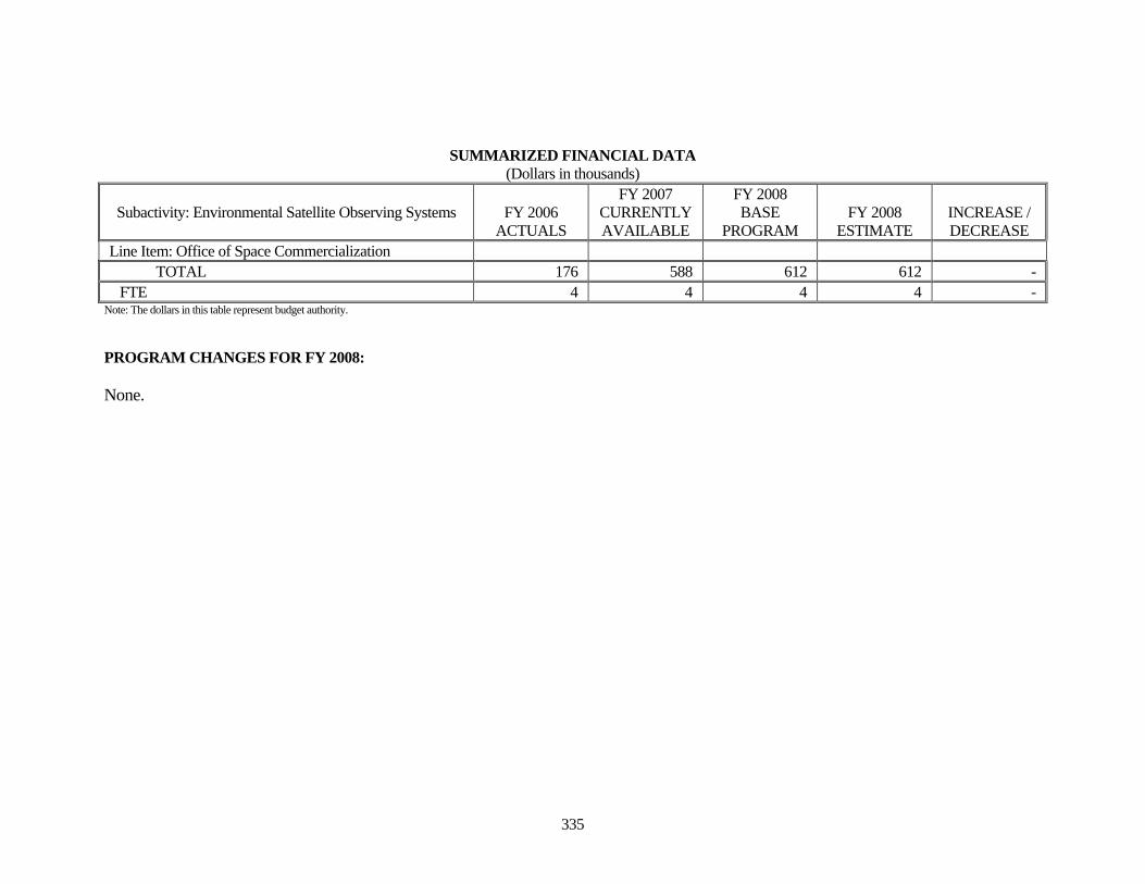
Line Item: Office of Space Commercialization TOTAL 176 588 612 612 - FTE 4 4 4 4 -
Note: The dollars in this table represent budget authority. PROGRAM CHANGES FOR FY 2008: None.
336
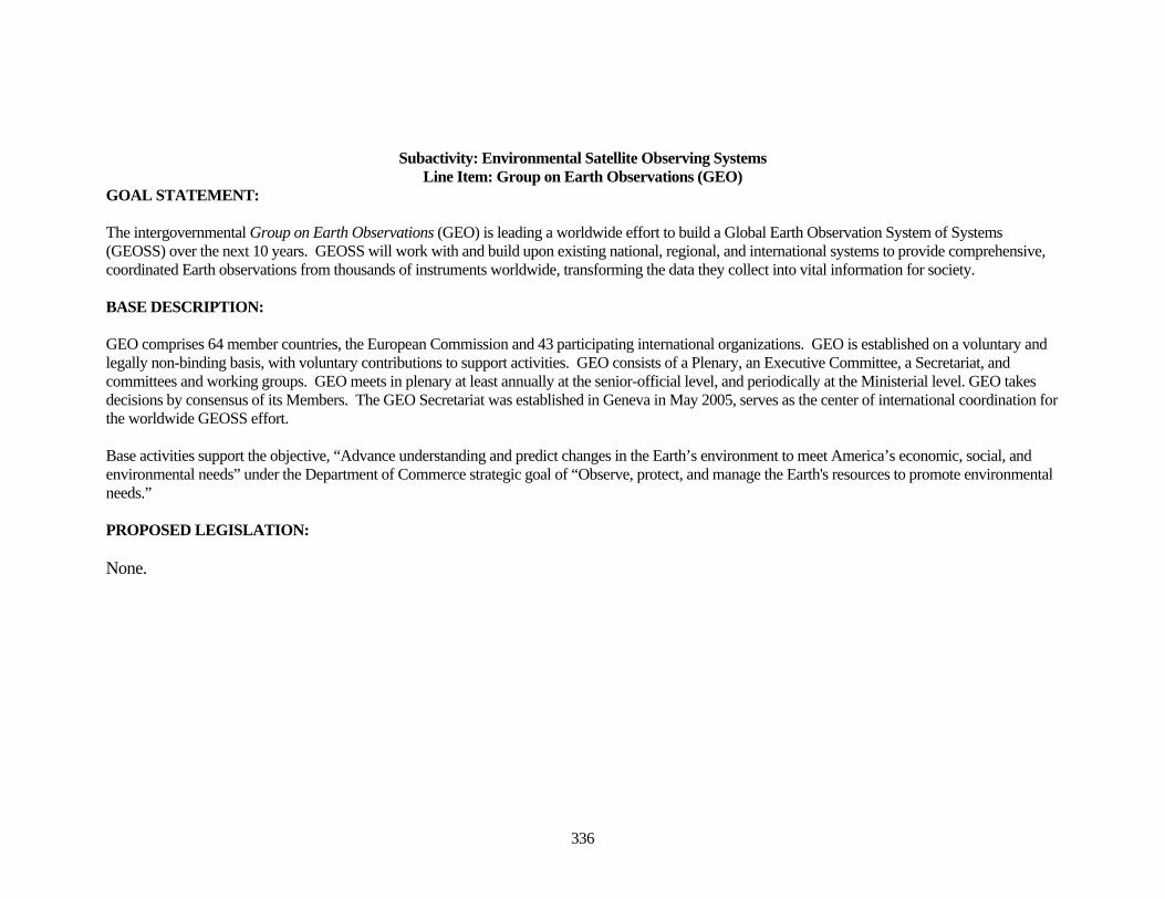
Subactivity: Environmental Satellite Observing Systems Line Item: Group on Earth Observations (GEO)
GOAL STATEMENT: The intergovernmental Group on Earth Observations (GEO) is leading a worldwide effort to build a Global Earth Observation System of Systems (GEOSS) over the next 10 years. GEOSS will work with and build upon existing national, regional, and international systems to provide comprehensive, coordinated Earth observations from thousands of instruments worldwide, transforming the data they collect into vital information for society. BASE DESCRIPTION: GEO comprises 64 member countries, the European Commission and 43 participating international organizations. GEO is established on a voluntary and legally non-binding basis, with voluntary contributions to support activities. GEO consists of a Plenary, an Executive Committee, a Secretariat, and committees and working groups. GEO meets in plenary at least annually at the senior-official level, and periodically at the Ministerial level. GEO takes decisions by consensus of its Members. The GEO Secretariat was established in Geneva in May 2005, serves as the center of international coordination for the worldwide GEOSS effort. Base activities support the objective, “Advance understanding and predict changes in the Earth’s environment to meet America’s economic, social, and environmental needs” under the Department of Commerce strategic goal of “Observe, protect, and manage the Earth's resources to promote environmental needs.” PROPOSED LEGISLATION: None.
337
SUMMARIZED FINANCIAL DATA (Dollars in thousands)
Subactivity: Environmental Satellite Observing Systems FY 2006 ACTUALS
FY 2007 CURRENTLY AVAILABLE
FY 2008 BASE
PROGRAM FY 2008
ESTIMATE INCREASE / DECREASE
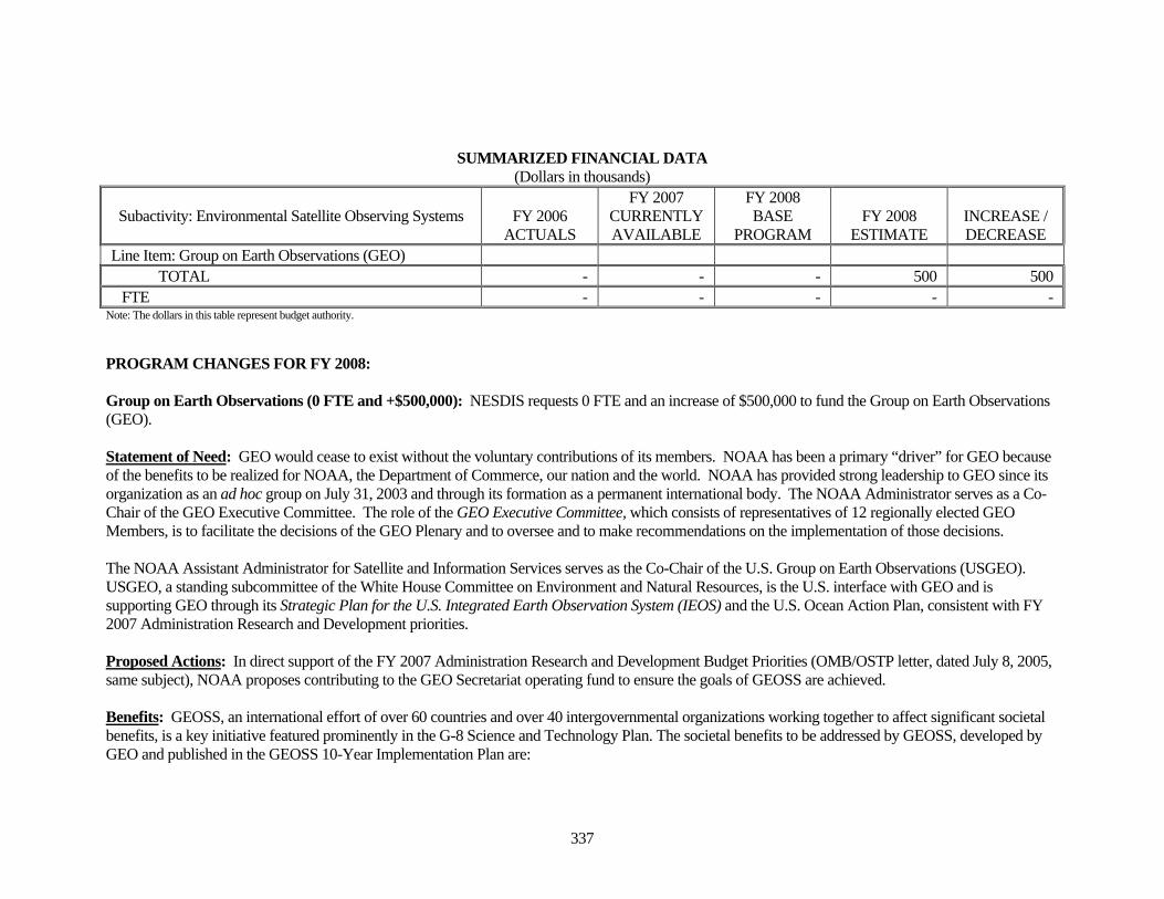
Line Item: Group on Earth Observations (GEO) TOTAL - - - 500 500 FTE - - - - -
Note: The dollars in this table represent budget authority. PROGRAM CHANGES FOR FY 2008: Group on Earth Observations (0 FTE and +$500,000): NESDIS requests 0 FTE and an increase of $500,000 to fund the Group on Earth Observations (GEO). Statement of Need: GEO would cease to exist without the voluntary contributions of its members. NOAA has been a primary “driver” for GEO because of the benefits to be realized for NOAA, the Department of Commerce, our nation and the world. NOAA has provided strong leadership to GEO since its organization as an ad hoc group on July 31, 2003 and through its formation as a permanent international body. The NOAA Administrator serves as a Co-Chair of the GEO Executive Committee. The role of the GEO Executive Committee, which consists of representatives of 12 regionally elected GEO Members, is to facilitate the decisions of the GEO Plenary and to oversee and to make recommendations on the implementation of those decisions. The NOAA Assistant Administrator for Satellite and Information Services serves as the Co-Chair of the U.S. Group on Earth Observations (USGEO). USGEO, a standing subcommittee of the White House Committee on Environment and Natural Resources, is the U.S. interface with GEO and is supporting GEO through its Strategic Plan for the U.S. Integrated Earth Observation System (IEOS) and the U.S. Ocean Action Plan, consistent with FY 2007 Administration Research and Development priorities. Proposed Actions: In direct support of the FY 2007 Administration Research and Development Budget Priorities (OMB/OSTP letter, dated July 8, 2005, same subject), NOAA proposes contributing to the GEO Secretariat operating fund to ensure the goals of GEOSS are achieved. Benefits: GEOSS, an international effort of over 60 countries and over 40 intergovernmental organizations working together to affect significant societal benefits, is a key initiative featured prominently in the G-8 Science and Technology Plan. The societal benefits to be addressed by GEOSS, developed by GEO and published in the GEOSS 10-Year Implementation Plan are:
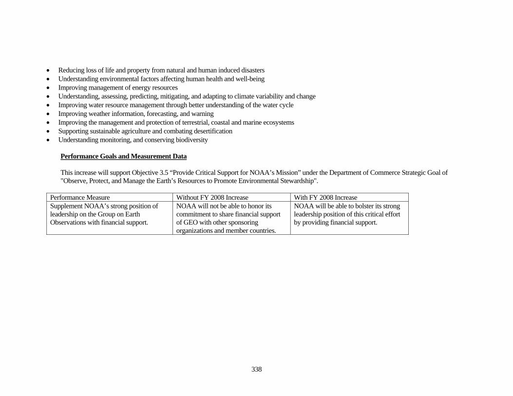
338
• Reducing loss of life and property from natural and human induced disasters • Understanding environmental factors affecting human health and well-being • Improving management of energy resources • Understanding, assessing, predicting, mitigating, and adapting to climate variability and change • Improving water resource management through better understanding of the water cycle • Improving weather information, forecasting, and warning • Improving the management and protection of terrestrial, coastal and marine ecosystems • Supporting sustainable agriculture and combating desertification • Understanding monitoring, and conserving biodiversity
Performance Goals and Measurement Data This increase will support Objective 3.5 “Provide Critical Support for NOAA’s Mission” under the Department of Commerce Strategic Goal of "Observe, Protect, and Manage the Earth’s Resources to Promote Environmental Stewardship".
Performance Measure Without FY 2008 Increase With FY 2008 Increase Supplement NOAA’s strong position of leadership on the Group on Earth Observations with financial support.
NOAA will not be able to honor its commitment to share financial support of GEO with other sponsoring organizations and member countries.
NOAA will be able to bolster its strong leadership position of this critical effort by providing financial support.
339
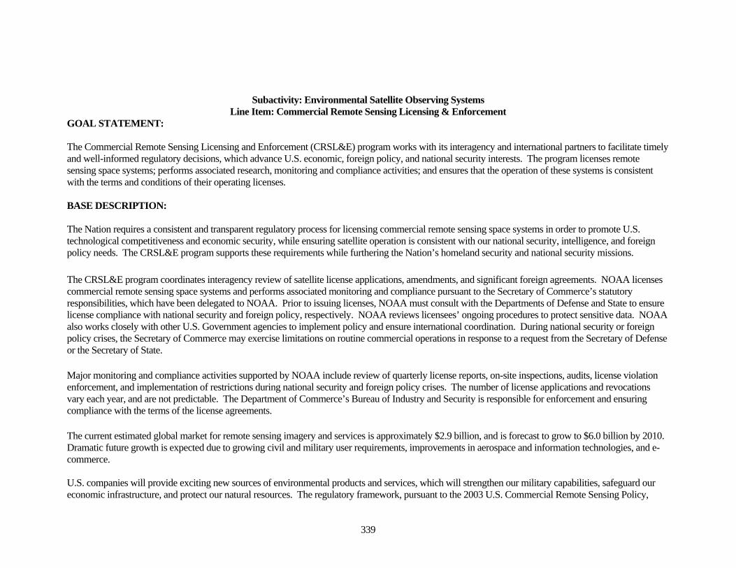
Subactivity: Environmental Satellite Observing Systems Line Item: Commercial Remote Sensing Licensing & Enforcement
GOAL STATEMENT: The Commercial Remote Sensing Licensing and Enforcement (CRSL&E) program works with its interagency and international partners to facilitate timely and well-informed regulatory decisions, which advance U.S. economic, foreign policy, and national security interests. The program licenses remote sensing space systems; performs associated research, monitoring and compliance activities; and ensures that the operation of these systems is consistent with the terms and conditions of their operating licenses. BASE DESCRIPTION: The Nation requires a consistent and transparent regulatory process for licensing commercial remote sensing space systems in order to promote U.S. technological competitiveness and economic security, while ensuring satellite operation is consistent with our national security, intelligence, and foreign policy needs. The CRSL&E program supports these requirements while furthering the Nation’s homeland security and national security missions. The CRSL&E program coordinates interagency review of satellite license applications, amendments, and significant foreign agreements. NOAA licenses commercial remote sensing space systems and performs associated monitoring and compliance pursuant to the Secretary of Commerce’s statutory responsibilities, which have been delegated to NOAA. Prior to issuing licenses, NOAA must consult with the Departments of Defense and State to ensure license compliance with national security and foreign policy, respectively. NOAA reviews licensees’ ongoing procedures to protect sensitive data. NOAA also works closely with other U.S. Government agencies to implement policy and ensure international coordination. During national security or foreign policy crises, the Secretary of Commerce may exercise limitations on routine commercial operations in response to a request from the Secretary of Defense or the Secretary of State. Major monitoring and compliance activities supported by NOAA include review of quarterly license reports, on-site inspections, audits, license violation enforcement, and implementation of restrictions during national security and foreign policy crises. The number of license applications and revocations vary each year, and are not predictable. The Department of Commerce’s Bureau of Industry and Security is responsible for enforcement and ensuring compliance with the terms of the license agreements. The current estimated global market for remote sensing imagery and services is approximately $2.9 billion, and is forecast to grow to $6.0 billion by 2010. Dramatic future growth is expected due to growing civil and military user requirements, improvements in aerospace and information technologies, and e-commerce. U.S. companies will provide exciting new sources of environmental products and services, which will strengthen our military capabilities, safeguard our economic infrastructure, and protect our natural resources. The regulatory framework, pursuant to the 2003 U.S. Commercial Remote Sensing Policy,
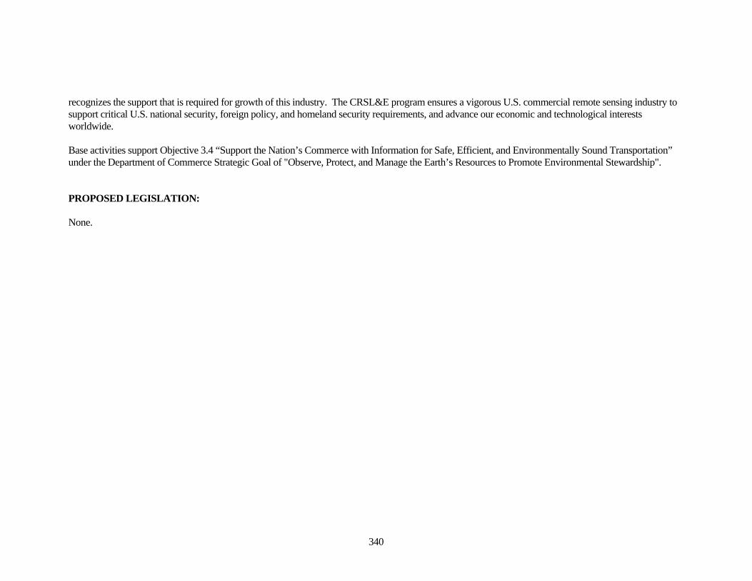
340
recognizes the support that is required for growth of this industry. The CRSL&E program ensures a vigorous U.S. commercial remote sensing industry to support critical U.S. national security, foreign policy, and homeland security requirements, and advance our economic and technological interests worldwide. Base activities support Objective 3.4 “Support the Nation’s Commerce with Information for Safe, Efficient, and Environmentally Sound Transportation” under the Department of Commerce Strategic Goal of "Observe, Protect, and Manage the Earth’s Resources to Promote Environmental Stewardship". PROPOSED LEGISLATION: None.
341
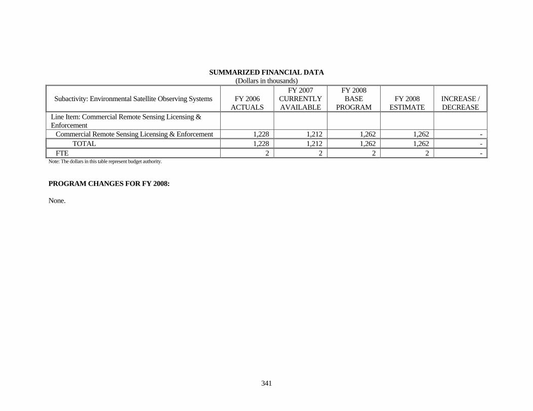
SUMMARIZED FINANCIAL DATA (Dollars in thousands)
Subactivity: Environmental Satellite Observing Systems FY 2006 ACTUALS
FY 2007 CURRENTLY AVAILABLE
FY 2008 BASE
PROGRAM FY 2008
ESTIMATE INCREASE / DECREASE
Line Item: Commercial Remote Sensing Licensing & Enforcement
Commercial Remote Sensing Licensing & Enforcement 1,228 1,212 1,262 1,262 - TOTAL 1,228 1,212 1,262 1,262 - FTE 2 2 2 2 -
Note: The dollars in this table represent budget authority. PROGRAM CHANGES FOR FY 2008: None.

342
THIS PAGE INTENTIONALLY LEFT BLANK
343
Subactivity: NOAA's Data Centers & Information Services Line Item: Archive, Access & Assessment
GOAL STATEMENT: The goal of Archive, Access, and Assessment (AAA) is to provide long-term archive, access (customer service), stewardship, and assessments of observation data to a wide range of worldwide users. Through NOAA’s three National Data Centers (NNDCs), environmental data, information, products, and services support atmospheric, oceanographic, and the solid earth and solar-terrestrial physical sciences to facilitate sustained economic growth, scientifically sound environmental management, and public safety to the Nation and the international community. BASE DESCRIPTION: The AAA line item provides the core funding for the three NNDCs: the National Climatic Data Center, the National Oceanographic Data Center, and the National Geophysical Data Center. This line item also supports the nation-wide NOAA library system, and data rescue activities through the Climate Database Modernization Program (CDMP). The NNDCs provide the Nation with the long-term stewardship archive of past, present, and future environmental observations and associated data recorded across the United States and globally. Access to long time series of environmental data is critical to satisfying the Nation’s wide range of needs related to the national security, the economy, the environment, and public safety. Approximately one-third of U. S. economic activity is weather sensitive and this figure continues to increase. Business and government policies and decisions impacting water and energy management, manufacturing, transportation, food production, public health, and many other socio-economic issues depend on quality climate and weather data records. Collectively, the three national data centers acquire over one petabyte (1015 ) of new data annually, provide access to an archive exceeding 3.5 petabytes, and support over 100 million worldwide queries per year, providing data transfers to over two million customers. By 2017, the projected ingest of new data will exceed seven petabytes per year and the cumulative archive volume managed and accessible to customers will exceed 144 petabytes. Climate Archive, Access, and Assessment: The National Climatic Data Center (NCDC), located in Asheville, North Carolina, is the largest climate data center in the world, and is the Nation’s designated federal records center for climate data. The NCDC receives, processes, archives, provides access, disseminates, and conducts objective assessments of remote (satellite) and in-situ (land, ocean, and atmosphere) observations. National and international observing systems provide both a national and a global perspective state of the Earth’s weather and climate. Paleoclimate “proxy” records, i.e., pre-instruments, such as ice and coral cores, and tree rings, are also collected, archived, and made available to the global community of researchers and other interested users. The NCDC also manages the conversion of historical data records to electronic format and accessibility via the Internet through the Climate Database Modernization Program. Over the past three years, the NCDC, in cooperation with scientists and other NOAA activities and federal agencies, has designed
344
and is deploying the Nation’s first climate quality observing network, the U. S. Climate Reference Network (USCRN). The NCDC is a designated World Data Center (WDC) for Meteorology and WDC for Paleoclimatology. The NCDC provides data, information, products and services to all sectors of the economy, delivering weather and climate data and information to nearly two million customers each year for planning, operations, and minimizing the risk of weather and climate extremes. Over one-third of the Gross National Product is weather and climate sensitive. The NCDC provides access and data retrieval via the worldwide web/Internet, and also responds to thousands of requests received via e-mail, phone, fax, and the mail. The NCDC routinely produces operational products for climate monitoring, such as the weekly and monthly State of the Climate reports, including the U.S. and the North American Drought Monitoring Reports. These and other assessments support business and government policy and decision makers and implementers. The NCDC works very closely with the Regional Climate Centers and state climatologists to provide support and services at regional and local levels. Ocean Archive, Access, and Assessment: The National Oceanographic Data Center (NODC), located in Silver Spring Maryland, is the nation’s permanent archive for oceanographic data, ensuring the public’s access to and the scientific stewardship of the long-term observational record of the global ocean, U.S. coastal waters and their ecosystems. These holdings document the physical and chemical properties of the oceans, currents, weather and biota as observed from ships, buoys, satellites and other ocean and coastal platforms extending back nearly 150 years. The NODC serves more than 800,000 users annually through the Internet and a variety of publications including atlases and technical reports published on digital media and paper. Examples of the most requested products include the World Ocean Database and Atlas, the International Atlas of the Ocean series, sea surface temperature climatology derived from satellites, and data sets gathered from operational ocean observing systems worldwide. The user community includes resource managers, researchers, educators, and maritime industry professionals from federal, state and local agencies as well as academia and the public. NODC is a designated World Data Center for Oceanography and provides leadership for international data exchange programs through the Intergovernmental Oceanographic Commission and provides national leadership in data management for the U.S. Integrated Ocean Observing System. The NOAA library, located within the NODC, operates on behalf of all agency programs to support NOAA staff in their work and provide public access to NOAA information. It includes the central library located in Silver Spring Maryland, and regional libraries in Seattle Washington, and Miami Florida. The central library also organizes agency-wide information services such as journal subscriptions and online reference services to support NOAA employees nationwide through 37 affiliated libraries at NOAA facilities throughout the United States. The NOAA library’s collection currently consists of over 1.7 million volumes and thousands of electronic documents and visual images on topics related to NOAA’s diverse missions. Geophysical Archive, Access, and Assessment: The National Geophysical Data Center (NGDC), located in Boulder Colorado, builds and maintains long-term archives of scientific data, with a special emphasis on scientific stewardship of data acquired by NOAA observing systems. Data holdings include bathymetry, solar, geophysical, space environment, and earth observing satellite data. The NGDC plays an integral role in the Nation's research into the environment, at the same time providing public domain data to a wide group of users. The NGDC: works very closely with NOAA’s Space Environment Center to provide archive and access of space-based and terrestrial space weather observations; works with contributors of scientific data to
345
prepare documented, reliable data sets, currently maintaining more than 850 digital and analog data sets; and continually develops data management programs that reflect the changing world of geophysics in an era of electronic data access. The NGDC operates World Data Centers for solid earth geophysics, marine geology and geophysics, solar terrestrial physics, and glaciology for the International Council of Science under the auspices of the U.S. National Academy of Sciences. Base activities at NOAA's Data Centers support all five objectives under the Department of Commerce Strategic goal of “Observe, Protect, and Manage the Earth's Resources to Promote Environmental Stewardship.” PROPOSED LEGISLATION: None.
346
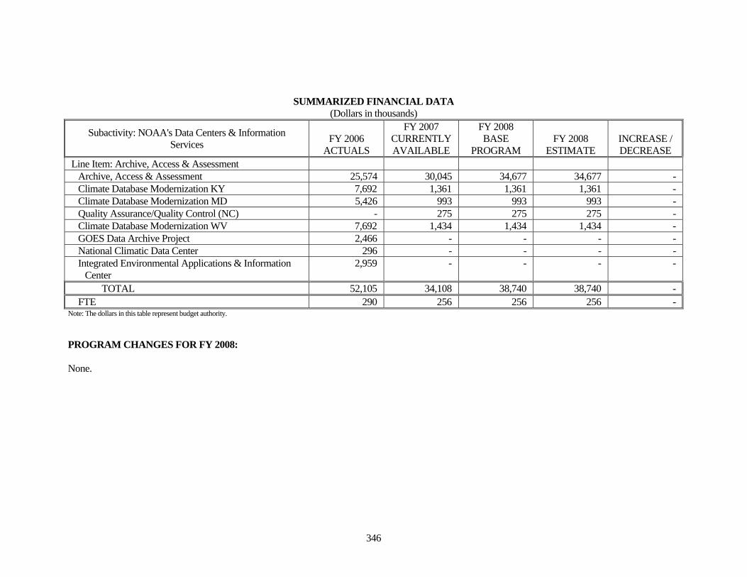
SUMMARIZED FINANCIAL DATA (Dollars in thousands)
Subactivity: NOAA's Data Centers & Information Services FY 2006
ACTUALS
FY 2007 CURRENTLY AVAILABLE
FY 2008 BASE
PROGRAM FY 2008
ESTIMATE INCREASE / DECREASE
Line Item: Archive, Access & Assessment Archive, Access & Assessment 25,574 30,045 34,677 34,677 - Climate Database Modernization KY 7,692 1,361 1,361 1,361 - Climate Database Modernization MD 5,426 993 993 993 - Quality Assurance/Quality Control (NC) - 275 275 275 - Climate Database Modernization WV 7,692 1,434 1,434 1,434 - GOES Data Archive Project 2,466 - - - - National Climatic Data Center 296 - - - - Integrated Environmental Applications & Information
Center 2,959 - - - -
TOTAL 52,105 34,108 38,740 38,740 - FTE 290 256 256 256 -
Note: The dollars in this table represent budget authority. PROGRAM CHANGES FOR FY 2008: None.
347
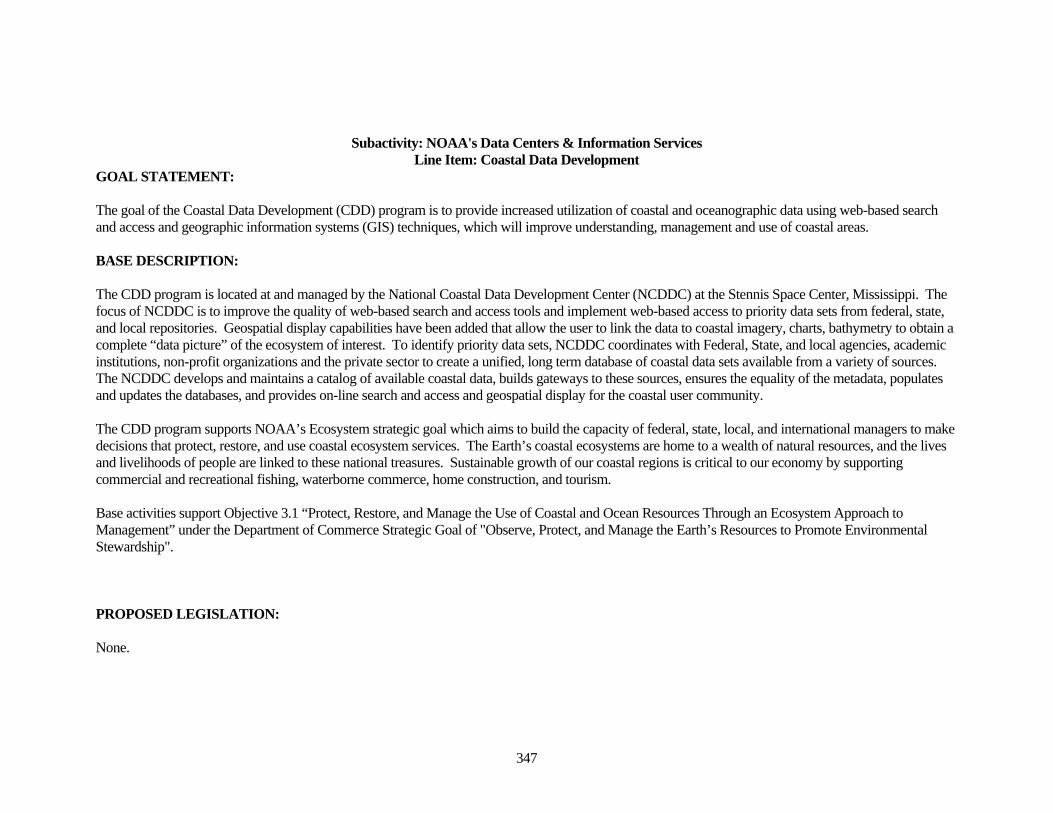
Subactivity: NOAA's Data Centers & Information Services Line Item: Coastal Data Development
GOAL STATEMENT: The goal of the Coastal Data Development (CDD) program is to provide increased utilization of coastal and oceanographic data using web-based search and access and geographic information systems (GIS) techniques, which will improve understanding, management and use of coastal areas. BASE DESCRIPTION: The CDD program is located at and managed by the National Coastal Data Development Center (NCDDC) at the Stennis Space Center, Mississippi. The focus of NCDDC is to improve the quality of web-based search and access tools and implement web-based access to priority data sets from federal, state, and local repositories. Geospatial display capabilities have been added that allow the user to link the data to coastal imagery, charts, bathymetry to obtain a complete “data picture” of the ecosystem of interest. To identify priority data sets, NCDDC coordinates with Federal, State, and local agencies, academic institutions, non-profit organizations and the private sector to create a unified, long term database of coastal data sets available from a variety of sources. The NCDDC develops and maintains a catalog of available coastal data, builds gateways to these sources, ensures the equality of the metadata, populates and updates the databases, and provides on-line search and access and geospatial display for the coastal user community. The CDD program supports NOAA’s Ecosystem strategic goal which aims to build the capacity of federal, state, local, and international managers to make decisions that protect, restore, and use coastal ecosystem services. The Earth’s coastal ecosystems are home to a wealth of natural resources, and the lives and livelihoods of people are linked to these national treasures. Sustainable growth of our coastal regions is critical to our economy by supporting commercial and recreational fishing, waterborne commerce, home construction, and tourism. Base activities support Objective 3.1 “Protect, Restore, and Manage the Use of Coastal and Ocean Resources Through an Ecosystem Approach to Management” under the Department of Commerce Strategic Goal of "Observe, Protect, and Manage the Earth’s Resources to Promote Environmental Stewardship". PROPOSED LEGISLATION: None.
348
SUMMARIZED FINANCIAL DATA (Dollars in thousands)
Subactivity: NOAA's Data Centers & Information Services FY 2006
ACTUALS
FY 2007 CURRENTLY AVAILABLE
FY 2008 BASE
PROGRAM FY 2008
ESTIMATE INCREASE / DECREASE
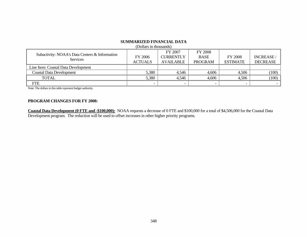
Line Item: Coastal Data Development Coastal Data Development 5,380 4,546 4,606 4,506 (100) TOTAL 5,380 4,546 4,606 4,506 (100) FTE - - - - -
Note: The dollars in this table represent budget authority. PROGRAM CHANGES FOR FY 2008: Coastal Data Development (0 FTE and -$100,000): NOAA requests a decrease of 0 FTE and $100,000 for a total of $4,506,000 for the Coastal Data Development program. The reduction will be used to offset increases in other higher priority programs.
349
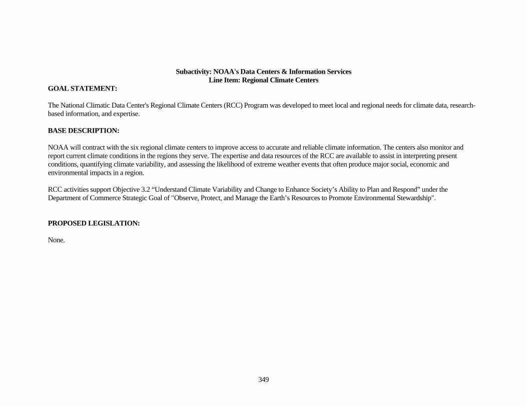
Subactivity: NOAA's Data Centers & Information Services Line Item: Regional Climate Centers
GOAL STATEMENT: The National Climatic Data Center's Regional Climate Centers (RCC) Program was developed to meet local and regional needs for climate data, research-based information, and expertise. BASE DESCRIPTION: NOAA will contract with the six regional climate centers to improve access to accurate and reliable climate information. The centers also monitor and report current climate conditions in the regions they serve. The expertise and data resources of the RCC are available to assist in interpreting present conditions, quantifying climate variability, and assessing the likelihood of extreme weather events that often produce major social, economic and environmental impacts in a region. RCC activities support Objective 3.2 “Understand Climate Variability and Change to Enhance Society’s Ability to Plan and Respond” under the Department of Commerce Strategic Goal of "Observe, Protect, and Manage the Earth’s Resources to Promote Environmental Stewardship". PROPOSED LEGISLATION: None.
350
SUMMARIZED FINANCIAL DATA (Dollars in thousands)
Subactivity: NOAA's Data Centers & Information Services FY 2006
ACTUALS
FY 2007 CURRENTLY AVAILABLE
FY 2008 BASE
PROGRAM FY 2008
ESTIMATE INCREASE / DECREASE
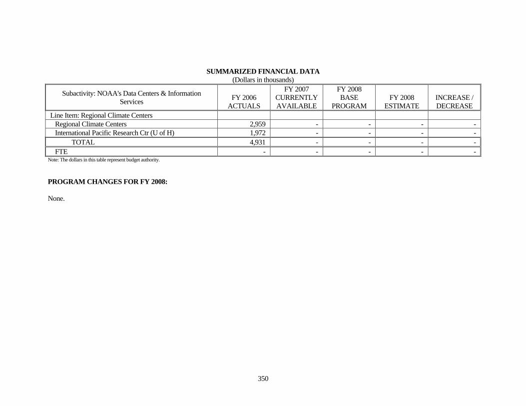
Line Item: Regional Climate Centers Regional Climate Centers 2,959 - - - - International Pacific Research Ctr (U of H) 1,972 - - - - TOTAL 4,931 - - - - FTE - - - - -
Note: The dollars in this table represent budget authority. PROGRAM CHANGES FOR FY 2008: None.
351
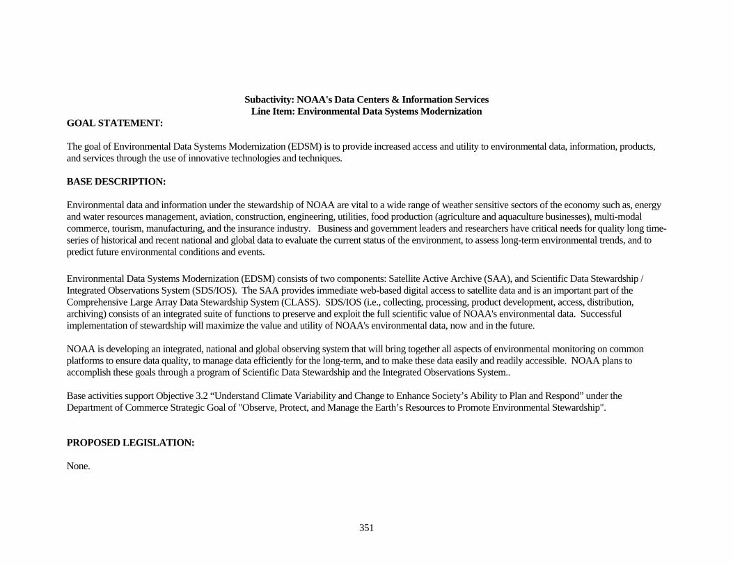
Subactivity: NOAA's Data Centers & Information Services Line Item: Environmental Data Systems Modernization
GOAL STATEMENT: The goal of Environmental Data Systems Modernization (EDSM) is to provide increased access and utility to environmental data, information, products, and services through the use of innovative technologies and techniques. BASE DESCRIPTION: Environmental data and information under the stewardship of NOAA are vital to a wide range of weather sensitive sectors of the economy such as, energy and water resources management, aviation, construction, engineering, utilities, food production (agriculture and aquaculture businesses), multi-modal commerce, tourism, manufacturing, and the insurance industry. Business and government leaders and researchers have critical needs for quality long time-series of historical and recent national and global data to evaluate the current status of the environment, to assess long-term environmental trends, and to predict future environmental conditions and events. Environmental Data Systems Modernization (EDSM) consists of two components: Satellite Active Archive (SAA), and Scientific Data Stewardship / Integrated Observations System (SDS/IOS). The SAA provides immediate web-based digital access to satellite data and is an important part of the Comprehensive Large Array Data Stewardship System (CLASS). SDS/IOS (i.e., collecting, processing, product development, access, distribution, archiving) consists of an integrated suite of functions to preserve and exploit the full scientific value of NOAA's environmental data. Successful implementation of stewardship will maximize the value and utility of NOAA's environmental data, now and in the future. NOAA is developing an integrated, national and global observing system that will bring together all aspects of environmental monitoring on common platforms to ensure data quality, to manage data efficiently for the long-term, and to make these data easily and readily accessible. NOAA plans to accomplish these goals through a program of Scientific Data Stewardship and the Integrated Observations System.. Base activities support Objective 3.2 “Understand Climate Variability and Change to Enhance Society’s Ability to Plan and Respond” under the Department of Commerce Strategic Goal of "Observe, Protect, and Manage the Earth’s Resources to Promote Environmental Stewardship". PROPOSED LEGISLATION: None.
352
SUMMARIZED FINANCIAL DATA (Dollars in thousands)
Subactivity: NOAA's Data Centers & Information Services FY 2006
ACTUALS
FY 2007 CURRENTLY AVAILABLE
FY 2008 BASE
PROGRAM FY 2008
ESTIMATE INCREASE / DECREASE
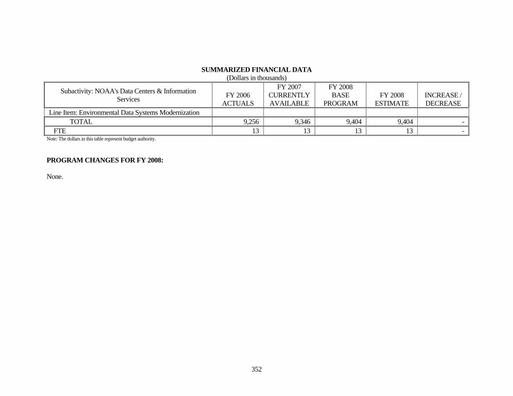
Line Item: Environmental Data Systems Modernization TOTAL 9,256 9,346 9,404 9,404 - FTE 13 13 13 13 -
Note: The dollars in this table represent budget authority. PROGRAM CHANGES FOR FY 2008: None.
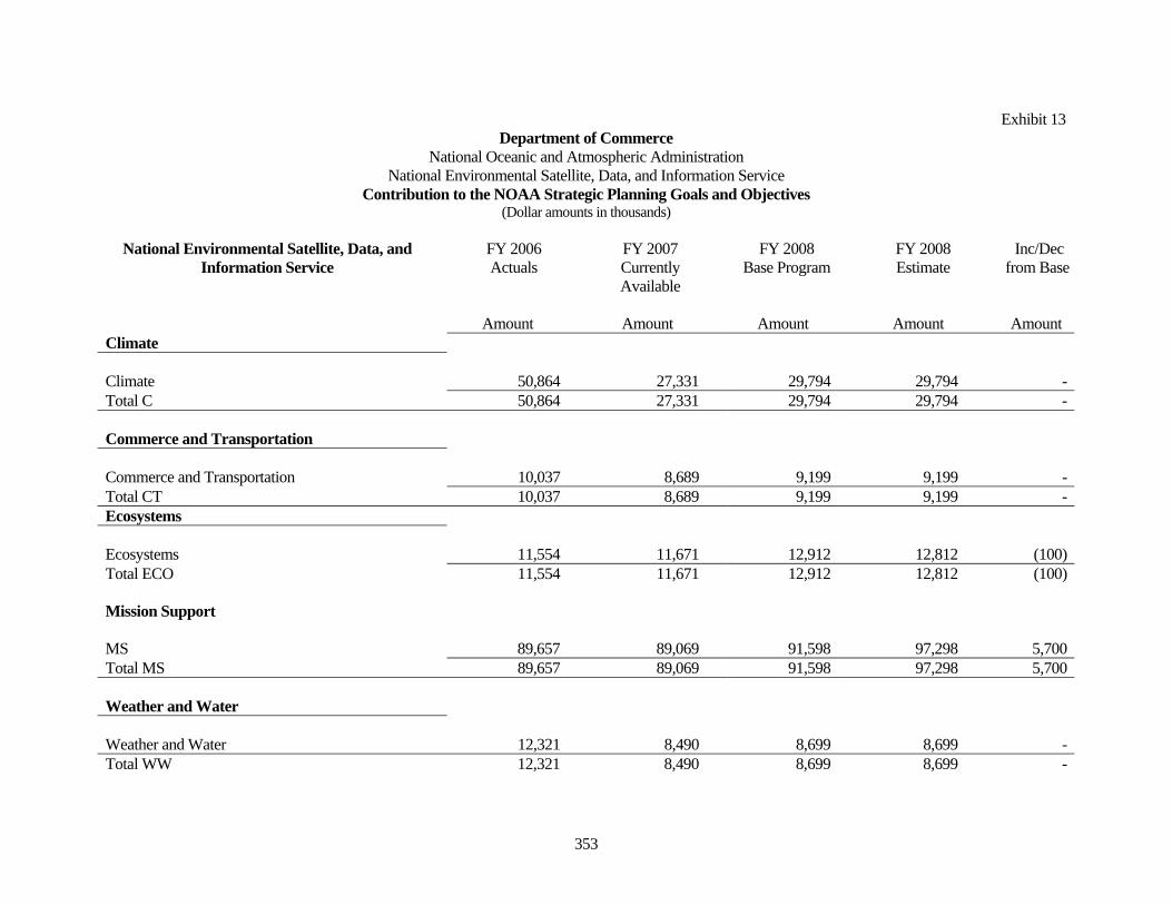
Exhibit 13 Department of Commerce
National Oceanic and Atmospheric Administration National Environmental Satellite, Data, and Information Service
Contribution to the NOAA Strategic Planning Goals and Objectives (Dollar amounts in thousands)
353
National Environmental Satellite, Data, and Information Service
FY 2006 Actuals
FY 2007 Currently Available
FY 2008 Base Program
FY 2008 Estimate
Inc/Dec from Base
Amount Amount Amount Amount Amount
Climate Climate 50,864 27,331 29,794 29,794 - Total C 50,864 27,331 29,794 29,794 - Commerce and Transportation Commerce and Transportation 10,037 8,689 9,199 9,199 - Total CT 10,037 8,689 9,199 9,199 - Ecosystems Ecosystems 11,554 11,671 12,912 12,812 (100) Total ECO 11,554 11,671 12,912 12,812 (100) Mission Support MS 89,657 89,069 91,598 97,298 5,700 Total MS 89,657 89,069 91,598 97,298 5,700 Weather and Water Weather and Water 12,321 8,490 8,699 8,699 - Total WW 12,321 8,490 8,699 8,699 -
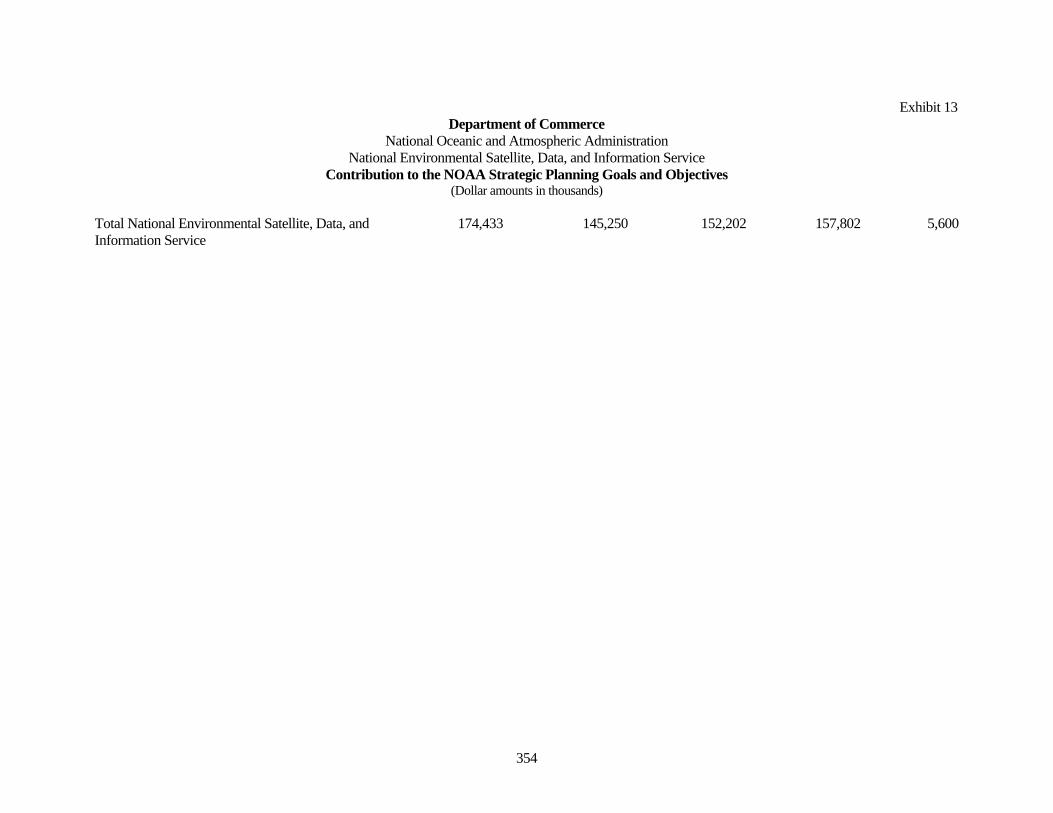
Exhibit 13 Department of Commerce
National Oceanic and Atmospheric Administration National Environmental Satellite, Data, and Information Service
Contribution to the NOAA Strategic Planning Goals and Objectives (Dollar amounts in thousands)
354
Total National Environmental Satellite, Data, and Information Service
174,433 145,250 152,202 157,802 5,600
Exhibit 10
Department of Commerce National Oceanic and Atmospheric Administration
Operations Research and Facilities PROGRAM AND PERFORMANCE: DIRECT OBLIGATIONS
(Dollar amounts in thousands)
355
Activity: National Environmental Satellite, Data, and Information Service
FY 2006 Actuals
FY 2007 Currently Available
FY 2008 Base Program
FY 2008 Estimate
Inc/Dec from Base
Personnel Amount Personnel Amount Personnel Amount Personnel Amount Personnel Amount Environmental Satellite Observing Systems
Pos/BA 187 40,471 187 43,750 187 44,499 187 44,499 - - Satellite Command and Control FTE/OBL 159 45,245 179 43,767 179 44,499 179 44,499 - -
Pos/BA 131 27,161 131 27,100 131 27,808 131 30,408 - 2,600 Product Processing and
Distribution FTE/OBL 109 27,643 123 27,118 123 27,808 123 30,408 - 2,600
Pos/BA 107 33,725 107 24,600 107 25,271 107 27,871 - 2,600 Product Development, Readiness & Application FTE/OBL 92 34,211 101 24,604 101 25,271 101 27,871 - 2,600
Pos/BA 4 176 4 588 4 612 4 612 - - Office of Space
Commercialization FTE/OBL 6 782 4 621 4 612 4 612 - -
Pos/BA - - - - - - - 500 - 500 Group on Earth Observations (GEO) FTE/OBL - - - - - - - 500 - 500
Pos/BA 2 1,228 2 1,212 2 1,262 2 1,262 - - Commercial Remote Sensing
Licensing & Enforcement FTE/OBL 14 1,294 2 1,224 2 1,262 2 1,262 - -
Pos/BA 431 102,761 431 97,250 431 99,452 431 105,152 - 5,700 Total: Environmental Satellite Observing Systems FTE/OBL 380 109,175 409 97,334 409 99,452 409 105,152 - 5,700
Exhibit 10
Department of Commerce National Oceanic and Atmospheric Administration
Operations Research and Facilities PROGRAM AND PERFORMANCE: DIRECT OBLIGATIONS
(Dollar amounts in thousands)
356
NOAA's Data Centers & Information Services Pos/BA 302 52,105 302 34,108 302 38,740 302 38,740 - - Archive, Access & Assessment FTE/OBL 172 53,013 256 34,111 256 38,740 256 38,740 - -
Pos/BA - 5,380 - 4,546 - 4,606 - 4,506 - (100) Coastal Data Development FTE/OBL 13 5,406 - 4,548 - 4,606 - 4,506 - (100)
Pos/BA - 4,931 - - - - - - - - Regional Climate Centers FTE/OBL 3 4,931 - 3 - - - - - -
Pos/BA 13 9,256 13 9,346 13 9,404 13 9,404 - - Environmental Data Systems
Modernization FTE/OBL 44 9,662 13 9,346 13 9,404 13 9,404 - -
Total: NOAA's Data Centers & Information Services
Pos/BA 315 71,672 315 48,000 315 52,750 315 52,650 - (100)
FTE/OBL 232 73,012 269 48,008 269 52,750 269 52,650 - (100)
Exhibit 15
Department of Commerce National Oceanic and Atmospheric Administration
Operations Research and Facilities PROGRAM CHANGE DETAIL BY OBJECT CLASS
(Dollar amounts in thousands)
357
Activity: National Environmental Satellite, Data, and Information Service Subactivity: Environmental Satellite Observing Systems
Object Class
2008 Increase
21 Travel and transportation of persons 25 25.2 Other services 3,100 25.5 Research and development contracts 2,050 31 Equipment 25 41.1 Grants, subsides and contributions 500 99 Total Obligations 5,700
Exhibit 15
Department of Commerce National Oceanic and Atmospheric Administration
Operations Research and Facilities PROGRAM CHANGE DETAIL BY OBJECT CLASS
(Dollar amounts in thousands)
358
Activity: National Environmental Satellite, Data, and Information Service Subactivity: NOAA's Data Centers & Information Services
Object Class
2008 Decrease
25.2 Other services (100) 99 Total Obligations (100)