Embed Size (px)
Citation preview
1
NESDIS COPC UPDATESpring 2010
Kathy KellyDirector NOAA/NESDIS
Office of Satellite Products and Operations*
11
*OSDPD + OSO = OSPO
22
Outline
• GOES/POES and NOAA Partnered Satellite Status
• Non-NOAA Update
• ESPC System Freeze
• Products Transitioned to Operations
• Backup Slides
2
333

44
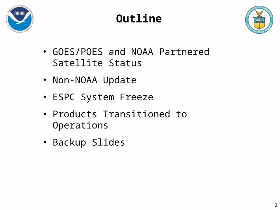
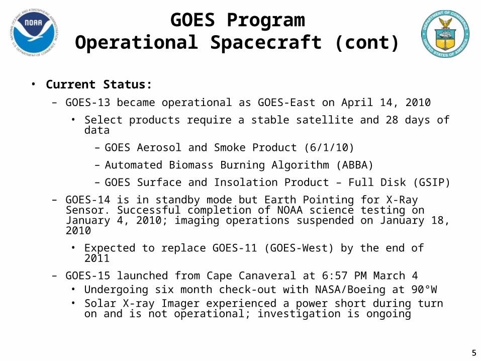
GOES ProgramOperational Spacecraft (cont)
• Current Status:
– GOES-11 is the operational GOES-West and should continue as such until December 2011
– GOES-12 ended East operations support on April 14, 2010
• Spacecraft being moved to support South American users
• Began eastward drift on April 27, 2010 and will commence imaging operations on May 11, 2010
• Scanning Strategy will the same as GOES-10– 15 minute South American Continent imagery scans– Four 1 hour sounder scans of the Continent– Data will not be ingested at NSOF
4
5
GOES ProgramOperational Spacecraft (cont)
• Current Status:
– GOES-13 became operational as GOES-East on April 14, 2010
• Select products require a stable satellite and 28 days of data
– GOES Aerosol and Smoke Product (6/1/10)
– Automated Biomass Burning Algorithm (ABBA)
– GOES Surface and Insolation Product – Full Disk (GSIP)
– GOES-14 is in standby mode but Earth Pointing for X-Ray Sensor. Successful completion of NOAA science testing on January 4, 2010; imaging operations suspended on January 18, 2010
• Expected to replace GOES-11 (GOES-West) by the end of 2011
– GOES-15 launched from Cape Canaveral at 6:57 PM March 4• Undergoing six month check-out with NASA/Boeing at 90°W• Solar X-ray Imager experienced a power short during turn on and is
not operational; investigation is ongoing
5
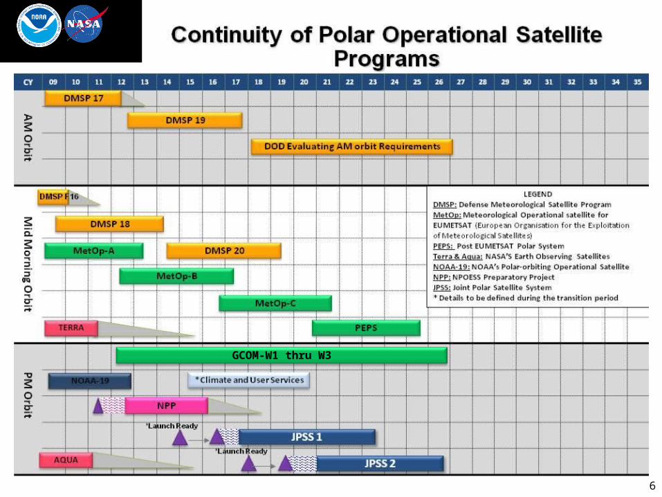
6
GCOM-W1 thru W3
7
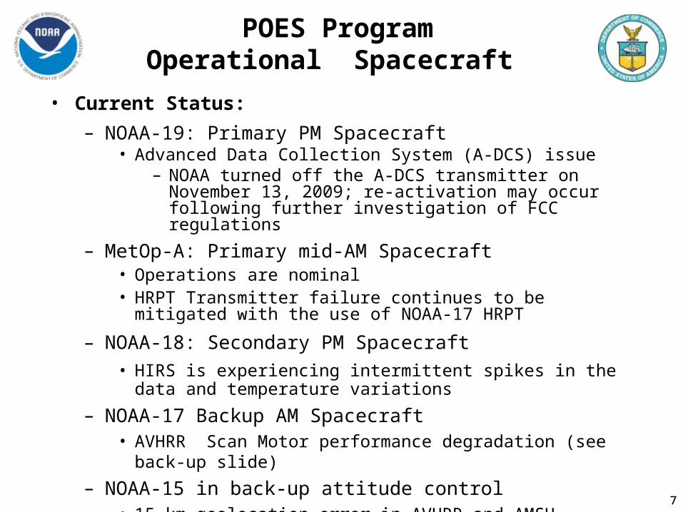
POES ProgramOperational Spacecraft
7
• Current Status:
– NOAA-19: Primary PM Spacecraft• Advanced Data Collection System (A-DCS) issue
– NOAA turned off the A-DCS transmitter on November 13, 2009; re-activation may occur following further investigation of FCC regulations
– MetOp-A: Primary mid-AM Spacecraft• Operations are nominal• HRPT Transmitter failure continues to be mitigated with the use of
NOAA-17 HRPT
– NOAA-18: Secondary PM Spacecraft
• HIRS is experiencing intermittent spikes in the data and temperature variations
– NOAA-17 Backup AM Spacecraft• AVHRR Scan Motor performance degradation (see back-up slide)
– NOAA-15 in back-up attitude control• 15 km geolocation error in AVHRR and AMSU

88
Jason-2
• Jason-2/Ocean Surface Topography Mission (OSTM)– NOAA commenced public distribution of the Jason-2 Geophysical Data
Records (GDR) from CNES on August 5, 2009– NOAA continues routine operations of Jason-2; includes command and
control through 2 U.S. and 1 European ground stations– Spacecraft, instruments, and ground system are performing nominally
8
9
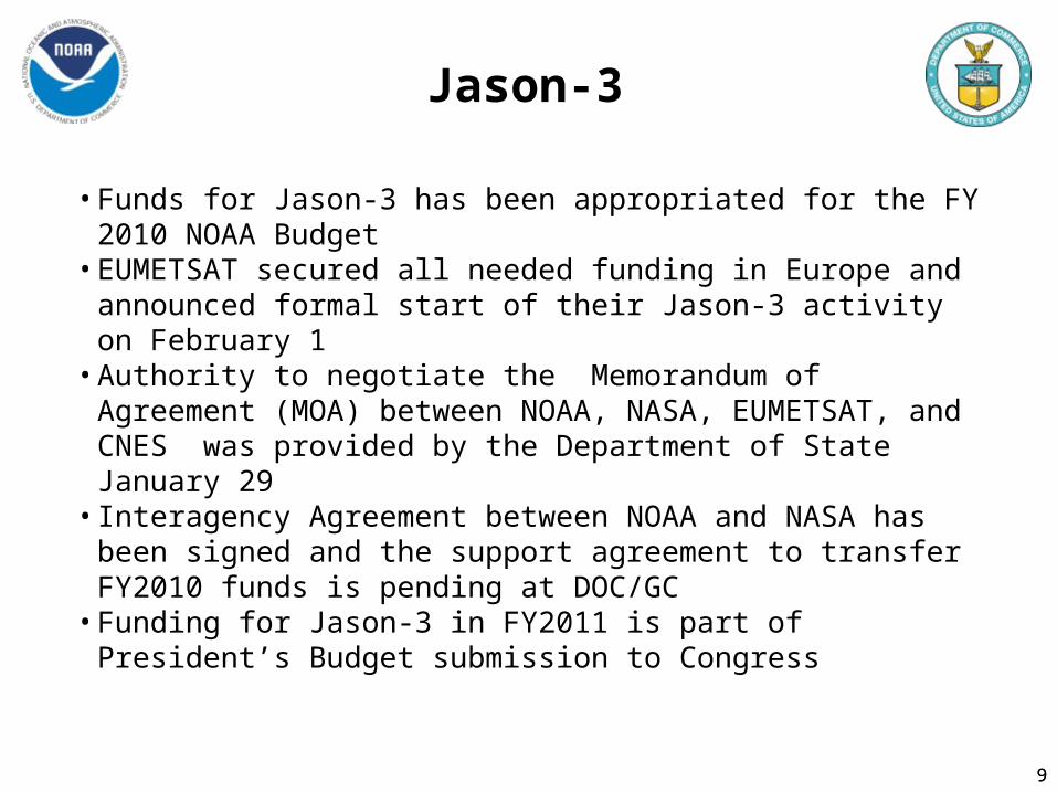
Jason-3
• Funds for Jason-3 has been appropriated for the FY 2010 NOAA Budget
• EUMETSAT secured all needed funding in Europe and announced formal start of their Jason-3 activity on February 1
• Authority to negotiate the Memorandum of Agreement (MOA) between NOAA, NASA, EUMETSAT, and CNES was provided by the Department of State January 29
• Interagency Agreement between NOAA and NASA has been signed and the support agreement to transfer FY2010 funds is pending at DOC/GC
• Funding for Jason-3 in FY2011 is part of President’s Budget submission to Congress
9
10
DSCOVR
•This capability will provide solar winds data and Coronal Mass Ejection Imagery to support continuity of geomagnetic storm warnings
•Assumes partnership with NASA to refurbish DSCOVR satellite to meet Solar Wind mission
• Funds instrument and satellite refurbishment, operations, and data processing, archival and distribution; assumes USAF provides launch vehicle
10

11
2nd Qtr 3rd Qtr 4th Qtr 1st Qtr 2nd Qtr 3rd Qtr 4th Qtr 1st Qtr 2nd Qtr 3rd Qtr 4th Qtr 1st Qtr 2nd Qtr 3rd Qtr 4th QtrCY08 CY09 CY10 CY11 CY12
1st QtrNPP Launch
Oct 2011
NDE Status
NDE’s Build Cycle to Support NPP
Ingest
Distribution
Customer Services
Monitoring & Reporting
Product Generation
Pre-launch Ground Segment Tests
12
NDE Status
• Program Management– Emphasis on NPP Production but also addresses Joint Polar Satellite
System (JPSS) data production for NOAA Unique Products
• NPP data will be made available for early evaluation during the post launch checkout period
• NDE Transition to Operations Plan available in October 2010
• Data and Products– Development of NOAA-Unique Products on track
• Tailored Infrared and Microwave Sounder (CrIS/ATMS), hydrology products from ATMS, VIIRS polar winds, and SST
– netCDF4 to BUFR conversion tool development on track
• NPP microwave & infrared radiances available in BUFR

13
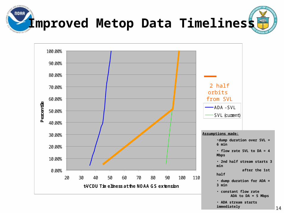
Improved Metop Data Timeliness
• Mid-2010- Eumetsat will increase the speed of data transmission from Svalbard to Darmstadt by adding a second connection and sending a half orbit over each connection resulting in 45 minute improvement in timeliness
• Testing between NESDIS and Eumetsat underway
• Mid-2011 through 2014- McMurdo Demonstration begins and 9 of 14 passes half orbits transferred from Antarctic CDA
• Mid-2014 All half orbits transferred from Antarctic CDA
13
14
0.00%
10.00%
20.00%
30.00%
40.00%
50.00%
60.00%
70.00%
80.00%
90.00%
100.00%
20 30 40 50 60 70 80 90 100 110
t-VCDU Timeliness at the NOAA GS extension
Per
cen
tile
ADA - SVL
SVL (current)
Assumptions made:
•dump duration over SVL = 6 min
• flow rate SVL to DA = 4 Mbps
• 2nd half stream starts 3 min after the 1st half
• dump duration for ADA = 3 min
• constant flow rate ADA to DA = 5 Mbps
• ADA stream starts immediately
2 half orbits from SVL
Improved Metop Data Timeliness
15
Non-NOAA Satellite missions
• GPS Radio Occultation (GPSRO)– COSMIC
• Distributing ~ 1000 useful occultations daily for NWP• Reduced from ~1500; two of six COSMIC sensors producing
anomalous data since Feb/March 2010– METOP/GRAS, GRACE
• ~ 700 useful occultations/day from GRAS/GRACE• These are being operationally assimilated by NWS/NCEP
Environmental Modeling Center since ~ March 1, 2010 • NESDIS exploring use of Fairbanks CDA to acquire
Argentine Satelite de Aplicaciones Cientificas-C (SAC-C RO) data
15
16
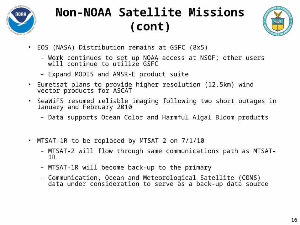
Non-NOAA Satellite Missions (cont)
• EOS (NASA) Distribution remains at GSFC (8x5)
– Work continues to set up NOAA access at NSOF; other users will continue to utilize GSFC
– Expand MODIS and AMSR-E product suite
• Eumetsat plans to provide higher resolution (12.5km) wind vector products for ASCAT
• SeaWiFS resumed reliable imaging following two short outages in January and February 2010
– Data supports Ocean Color and Harmful Algal Bloom products
• MTSAT-1R to be replaced by MTSAT-2 on 7/1/10
– MTSAT-2 will flow through same communications path as MTSAT-1R
– MTSAT-1R will become back-up to the primary
– Communication, Ocean and Meteorological Satellite (COMS) data under consideration to serve as a back-up data source
16
17
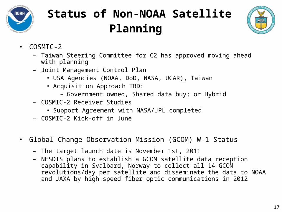
Status of Non-NOAA Satellite Planning
• COSMIC-2 – Taiwan Steering Committee for C2 has approved moving ahead with planning– Joint Management Control Plan
• USA Agencies (NOAA, DoD, NASA, UCAR), Taiwan• Acquisition Approach TBD:
– Government owned, Shared data buy; or Hybrid– COSMIC-2 Receiver Studies
• Support Agreement with NASA/JPL completed– COSMIC-2 Kick-off in June
• Global Change Observation Mission (GCOM) W-1 Status
– The target launch date is November 1st, 2011– NESDIS plans to establish a GCOM satellite data reception capability in
Svalbard, Norway to collect all 14 GCOM revolutions/day per satellite and disseminate the data to NOAA and JAXA by high speed fiber optic communications in 2012
17

18
Status of Non-NOAA Satellite Planning (cont)
• Future Plans for OceanSAT2 (ISRO)
– Launched late September 23, 2008
– NOAA is in discussion with India for near-realtime access to the Ocean Color Monitor and the Scanning Scatterometer data
18
19
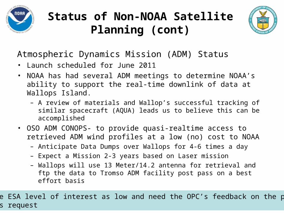
Status of Non-NOAA Satellite Planning (cont)
Atmospheric Dynamics Mission (ADM) Status• Launch scheduled for June 2011 • NOAA has had several ADM meetings to determine NOAA’s ability
to support the real-time downlink of data at Wallops Island. – A review of materials and Wallop’s successful tracking of similar
spacecraft (AQUA) leads us to believe this can be accomplished
• OSO ADM CONOPS- to provide quasi-realtime access to retrieved ADM wind profiles at a low (no) cost to NOAA– Anticipate Data Dumps over Wallops for 4-6 times a day
– Expect a Mission 2-3 years based on Laser mission
– Wallops will use 13 Meter/14.2 antenna for retrieval and ftp the data to Tromso ADM facility post pass on a best effort basis
Perceive ESA level of interest as low and need the OPC’s feedback on the priority of this request
20
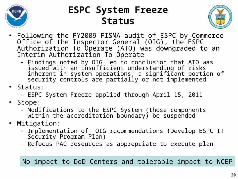
ESPC System Freeze Status
• Following the FY2009 FISMA audit of ESPC by Commerce Office of the Inspector General (OIG), the ESPC Authorization To Operate (ATO) was downgraded to an Interim Authorization To Operate– Findings noted by OIG led to conclusion that ATO was issued with an
insufficient understanding of risks inherent in system operations; a significant portion of security controls are partially or not implemented
• Status:– ESPC System Freeze applied through April 15, 2011
• Scope:– Modifications to the ESPC System (those components within the
accreditation boundary) be suspended • Mitigation:
– Implementation of OIG recommendations (Develop ESPC IT Security Program Plan)
– Refocus PAC resources as appropriate to execute plan
20
No impact to DoD Centers and tolerable impact to NCEP
21
Transition of Space Weather Data Processing to NESDIS
• NESDIS and the NWS plan to consolidate Space Weather L1 and L2 data processing at NSOF
• Work to transition data processing is underway:– FY10– Develop Project Plan and CONOPS (OSD)
• Develop requirements• Porting of ACE processing software to ESPC environment (STAR)• Begin porting GOES N-P processing software to ESPC environment
(STAR)– FY11
• Develop space weather processing system within ESPC environment (OSD)
• Upgrade alternate processing facility at Wallops Is. , VA (CIP site) to handle space weather data processing (OSD)
• Complete porting ACE and GOES N-P processing software (STAR)
NOAA’s SWPC provides the Nation’s official space weather alerts and forecasts
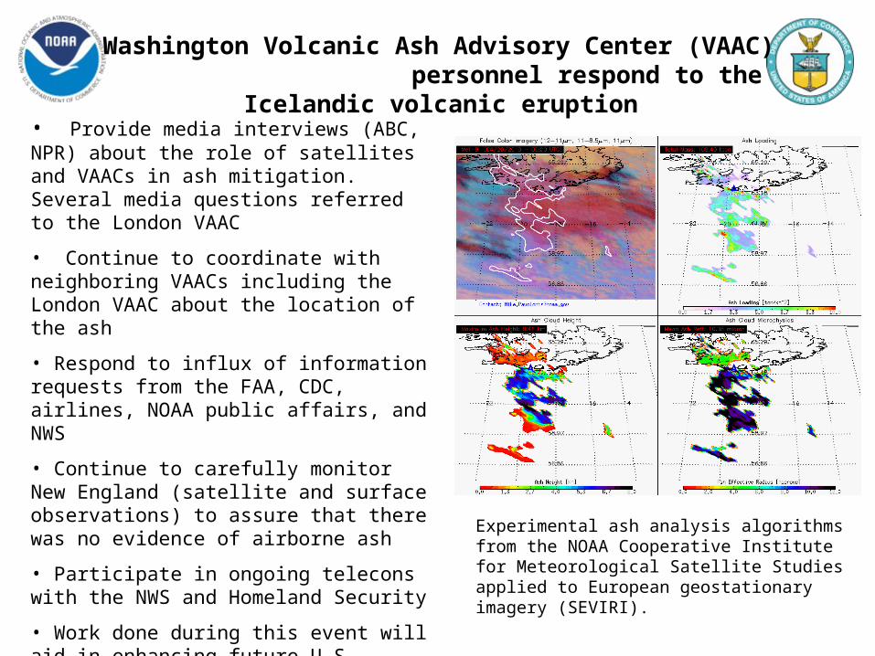
Washington Volcanic Ash Advisory Center (VAAC) personnel respond to the Icelandic volcanic eruption
• Provide media interviews (ABC, NPR) about the role of satellites and VAACs in ash mitigation. Several media questions referred to the London VAAC
• Continue to coordinate with neighboring VAACs including the London VAAC about the location of the ash
• Respond to influx of information requests from the FAA, CDC, airlines, NOAA public affairs, and NWS
• Continue to carefully monitor New England (satellite and surface observations) to assure that there was no evidence of airborne ash
• Participate in ongoing telecons with the NWS and Homeland Security
• Work done during this event will aid in enhancing future U.S. volcanic ash response
Experimental ash analysis algorithms from the NOAA Cooperative Institute for Meteorological Satellite Studies applied to European geostationary imagery (SEVIRI).
23
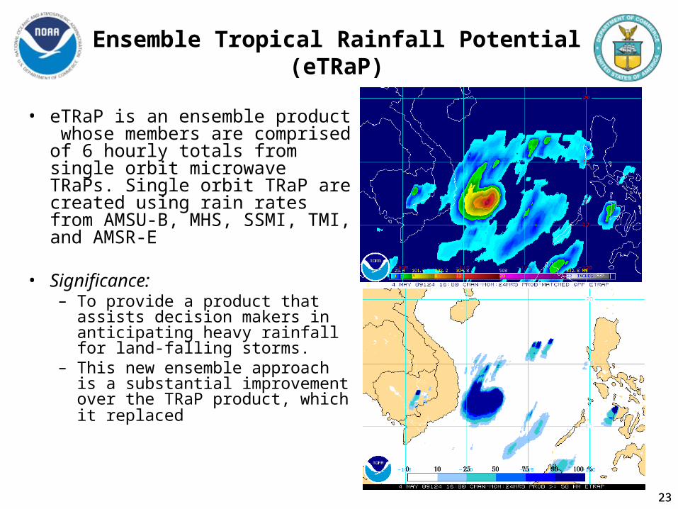
Ensemble Tropical Rainfall Potential (eTRaP)
• eTRaP is an ensemble product whose members are comprised of 6 hourly totals from single orbit microwave TRaPs. Single orbit TRaP are created using rain rates from AMSU-B, MHS, SSMI, TMI, and AMSR-E
• Significance: – To provide a product that assists
decision makers in anticipating heavy rainfall for land-falling storms.
– This new ensemble approach is a substantial improvement over the TRaP product, which it replaced
23
24
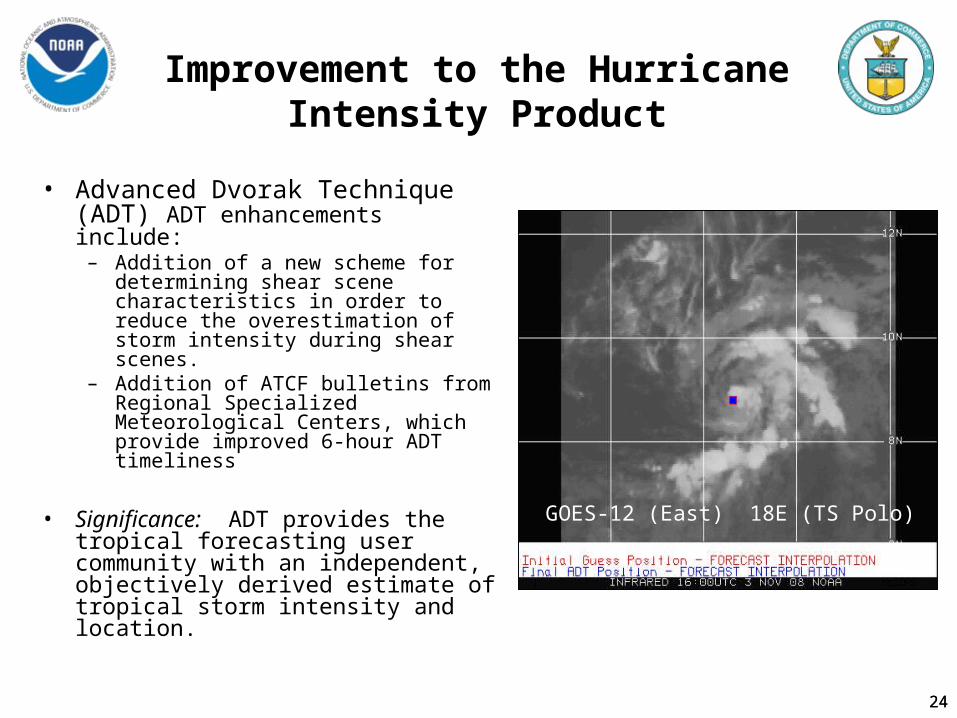
Improvement to the Hurricane Intensity Product
• Advanced Dvorak Technique (ADT) ADT enhancements include:
– Addition of a new scheme for determining shear scene characteristics in order to reduce the overestimation of storm intensity during shear scenes.
– Addition of ATCF bulletins from Regional Specialized Meteorological Centers, which provide improved 6-hour ADT timeliness
• Significance: ADT provides the tropical forecasting user community with an independent, objectively derived estimate of tropical storm intensity and location.
GOES-12 (East) 18E (TS Polo)
24
25
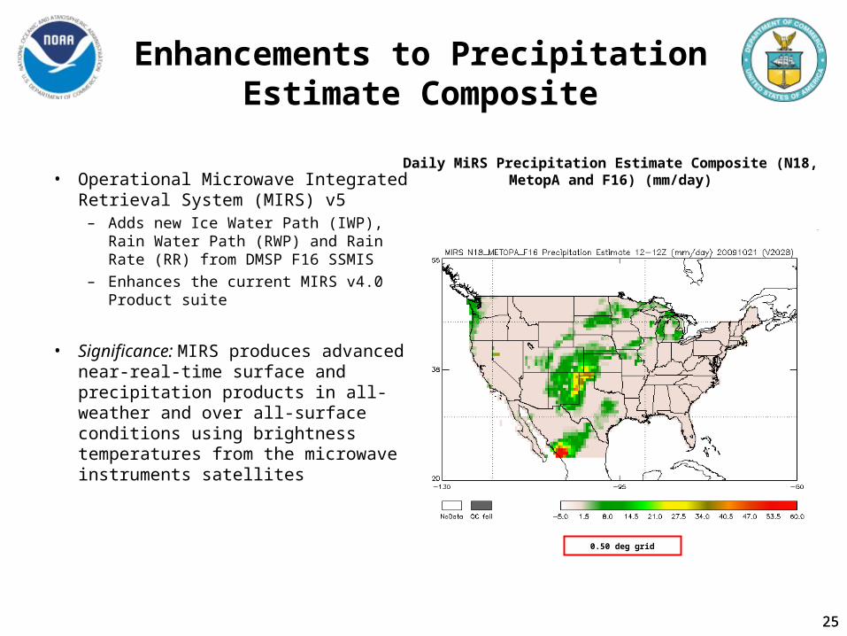
Enhancements to Precipitation Estimate Composite
• Operational Microwave Integrated Retrieval System (MIRS) v5
– Adds new Ice Water Path (IWP), Rain Water Path (RWP) and Rain Rate (RR) from DMSP F16 SSMIS
– Enhances the current MIRS v4.0 Product suite
• Significance: MIRS produces advanced near-real-time surface and precipitation products in all-weather and over all-surface conditions using brightness temperatures from the microwave instruments satellites
Daily MiRS Precipitation Estimate Composite (N18, MetopA and F16) (mm/day)
0.50 deg grid
25
26
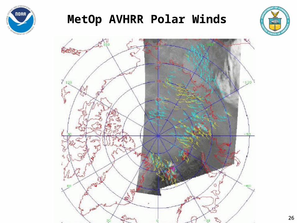
MetOp AVHRR Polar Winds
26
27
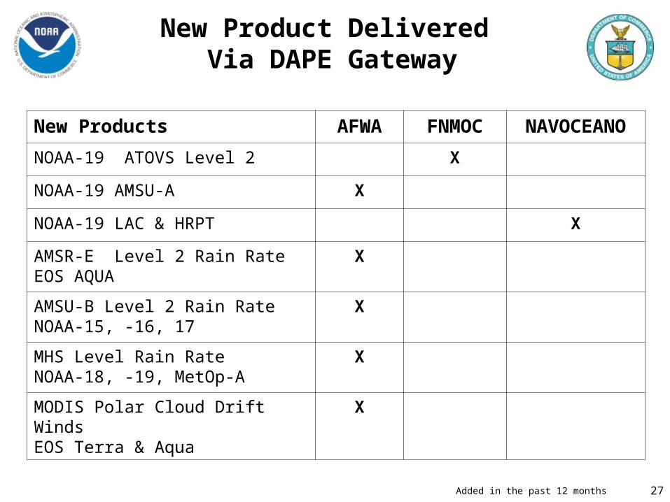
New Product Delivered Via DAPE Gateway
New Products AFWA FNMOC NAVOCEANO
NOAA-19 ATOVS Level 2 X
NOAA-19 AMSU-A X
NOAA-19 LAC & HRPT X
AMSR-E Level 2 Rain RateEOS AQUA
X
AMSU-B Level 2 Rain RateNOAA-15, -16, 17
X
MHS Level Rain RateNOAA-18, -19, MetOp-A
X
MODIS Polar Cloud Drift WindsEOS Terra & Aqua
X
Added in the past 12 months
28
Backup Slides
2828
29
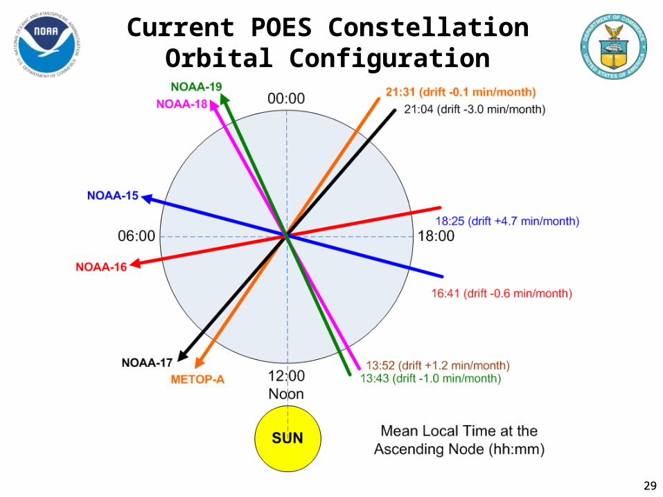
Current POES ConstellationOrbital Configuration
29
30
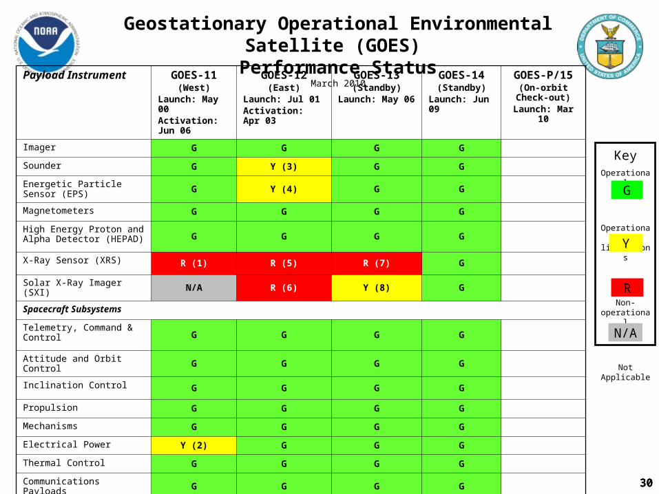
Geostationary Operational Environmental Satellite (GOES)
Performance StatusMarch 2010
Payload Instrument GOES-11(West)
Launch: May 00Activation: Jun 06
GOES-12(East)
Launch: Jul 01Activation: Apr 03
GOES-13(Standby)
Launch: May 06
GOES-14(Standby)
Launch: Jun 09
GOES-P/15(On-orbit Check-
out)Launch: Mar 10
Imager G G G G
Sounder G Y (3) G G
Energetic Particle Sensor (EPS) G Y (4) G G
Magnetometers G G G G
High Energy Proton and Alpha Detector (HEPAD) G G G G
X-Ray Sensor (XRS) R (1) R (5) R (7) G
Solar X-Ray Imager (SXI) N/A R (6) Y (8) G
Spacecraft Subsystems
Telemetry, Command & ControlG G G G
Attitude and Orbit Control G G G G
Inclination Control G G G G
Propulsion G G G G
Mechanisms G G G G
Electrical Power Y (2) G G G
Thermal Control G G G G
Communications Payloads G G G G
KeyOperational
Operational with limitations
Non-operational
Not Applicable
G
R
Y
N/A
303030

3131
Polar Operational Environmental Satellite (POES) Operational Status
12 April 2010
OperationalSpacecraft Issue but no user impacts S/CSeverly Degraded OOperational with limitations YNon-Operational RNot Applicable N/A
Y (12)

3232
NOAA-17 AVHRR Channel 1 Earth View (10/090 16:00 UTC)
Wavy patterns are scan to scan pixel shifts. The Scan Motor is not rotating smoothly, resulting in misalignment of the pixels from one scan to the next.

33
33
Polar Satellite Products and Services Status
G
Y
R
- Operational
- Scheduling, performance or capabilities limitation
- Not operational Or unable to process
Product Areas Key ProductsN-15 N-16 N-17 N-18 M2/A N-19
AVHRR 1B/Radiances G G Y G G GAMSU-A 1B/Radiances Y Y R G G GAMSU-B 1B//Radiances Y G G G G GHIRS 1B/Radiances Y Y G Y G GMHS 1B G GSBUV 1B G G G GSAR Telemetry G G G G G GDCS G G G G G GSEM G G G G G GVegetation Index G Y G G GFires/Smoke G G Y G G GVolcanic Ash G G G G G GSnow/Ice G G G G G GMSPPS (MIRS for N-18) Y G Y G G GSoundings Y R R Y G GOzone (SBUV or GOME) Y G G G GAerosols Retrievals G Y G G GRadiation Budget AVHRR G G Y G G GRadiation Budget HIRS Y Y G Y G GCLAVR-X G G Y G G GSea Surface Temp (Global) R Y Y G G GSea Surface Temp (Region) Y R Y G G GSea Ice G G G G G G
NON-NOAA IASI GASCAT GGOME G
Labd Products
Atmosphere Products
Ocean Products
Pre Products

34
34
Polar Satellite Products and Services Status
G
Y
R
- Operational
- Scheduling, performance or capabilities limitation
- Not operational Or unable to process
Product Areas Key ProductsN-15 N-16 N-17 N-18 M2/A N-19
SARSAT G G G G Y GARGOS DCS G G G G G GDB APT G R G G R GDB HRPT G G G G R G
Services