Embed Size (px)
Citation preview

N LAND AT GLENFALL WAY CHARLTON KINGS
CHELTENHAM GLOUCESTERSHIRE
ARCHAEOLOGICAL EVALUATION
For
STRATEGIC LAND PARTNERSHIPS
CA PROJECT: 2441 CA REPORT: 07136
OCTOBER 2007
LAND AT GLENFALL WAY CHARLTON KINGS
CHELTENHAM GLOUCESTERSHIRE
ARCHAEOLOGICAL EVALUATION
CA PROJECT: 2441 CA REPORT: 07136
prepared by Stuart Joyce: Project Supervisor
date
checked by Cliff Bateman: Project Manager
date
approved by Mark Collard: Head of Contracts
signed
date 16 October 2007
issue 01
This report is confidential to the client. Cotswold Archaeology accepts no responsibility or liability to any third party to whom this report, or any part of it, is made known. Any such party relies upon this report entirely
at their own risk. No part of this report may be reproduced by any means without permission.
© Cotswold Archaeology Building 11, Kemble Enterprise Park, Kemble, Cirencester, Gloucestershire, GL7 6BQ
Tel. 01285 771022 Fax. 01285 771033 E-mail: [email protected]

© Cotswold Archaeology Land at Glenfall Way, Charlton Kings, Cheltenham: Archaeological Evaluation
CONTENTS
SUMMARY........................................................................................................................ 2
1. INTRODUCTION ................................................................................................. 3
2. RESULTS ............................................................................................................ 5
3. DISCUSSION....................................................................................................... 5
4. CA PROJECT TEAM ........................................................................................... 6
5. REFERENCES .................................................................................................... 6
APPENDIX A: CONTEXT DESCRIPTIONS ..................................................................... 7 APPENDIX B: OASIS REPORT FORM............................................................................ 8
LIST OF ILLUSTRATIONS Fig. 1 Site location plan (1:25,000)
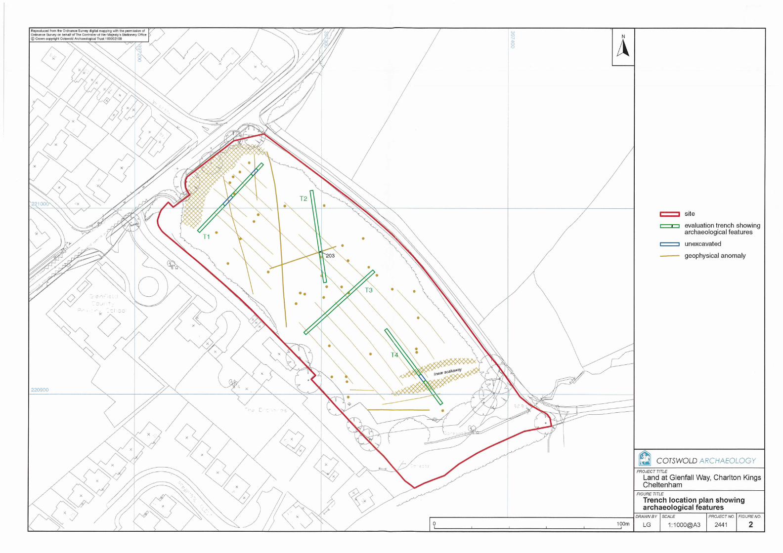
Fig. 2 Trench location plan (1:1000)
1
© Cotswold Archaeology Land at Glenfall Way, Charlton Kings, Cheltenham: Archaeological Evaluation
SUMMARY
Project Name: Land at Glenfall Way
Location: Charlton Kings, Cheltenham, Gloucestershire
NGR: SO 9735 2095
Type: Evaluation
Date: 10-11 October 2007
Location of Archive: Cheltenham Art Gallery and Museum
Site Code: GWC 07
An archaeological evaluation was undertaken by Cotswold Archaeology in October 2007 on
land off Glenfall Way, Charlton Kings, Gloucestershire at the request of Strategic Land
Partnerships. Four trenches were excavated.
No archaeological features were present within trenches 1, 3 and 4. A square cut ditch of
unknown, but probable modern, date was revealed in trench 2.
2

© Cotswold Archaeology Land at Glenfall Way, Charlton Kings, Cheltenham: Archaeological Evaluation
1. INTRODUCTION
1.1 In October 2007 Cotswold Archaeology (CA) carried out an archaeological
evaluation for Strategic Land Partnerships at Glenfall Way, Charlton Kings,
Cheltenham, Gloucestershire (centred on NGR: SO 9735 2095; Fig. 1). The
evaluation was undertaken prior to the submission of a planning application for
residential development at the site.
1.2 The evaluation was carried out following consultation with Charles Parry, Senior
Archaeological Officer, Gloucestershire County Council (GCC), the archaeological
advisor to the Local Planning Authority (LPA), and with a subsequent detailed
Written Scheme of Investigation (WSI) produced by CA (2007a) that was approved
by Charles Parry. The fieldwork also followed the Standard and Guidance for
Archaeological Field Evaluation issued by the Institute of Field Archaeologists
(2001), the Statement of Standards and Practices Appropriate for Archaeological
fieldwork in Gloucestershire (GCC 1996) and the Management of Archaeological
Projects (English Heritage 1991). It was monitored by Mr Parry.
The site
1.3 The proposed development area is approximately 1.8ha in area, and comprises a
field under pasture. The north-western limit of the site is bounded by Glenfall Way
with an access track forming the north-eastern boundary. The north-eastern area of
the site is flat and lies at approximately 98m AOD, with the ground level dropping
away in the south-eastern area of the site towards a small stream at approximately
93m.
1.4 The solid geology of the site comprises Lower Lias clays, silts and limestone of the
Jurassic Era, overlain throughout the majority of the site by Cheltenham Sand of the
Quaternary Period (BGS 1981).
Archaeological background
1.5 An Archaeological Desk-Based Assessment and subsequent geophysical survey
have recently been completed for the site. The assessment identified no features of
archaeological interest within the proposed development area or its immediate
3

© Cotswold Archaeology Land at Glenfall Way, Charlton Kings, Cheltenham: Archaeological Evaluation
vicinity (CA 2007b). The magnetometer survey identified a medieval ridge and
furrow field system throughout the site (although not visible on the ground), with a
number of linear and discrete anomalies of archaeological potential also being
recorded (Archaeological Surveys 2007).
Archaeological objectives
1.6 The objectives of the evaluation were to establish the character, quality, date and
extent of any archaeological remains or deposits surviving within the site. This
information will assist the LPA in making an informed judgement on the significance
of the archaeological resource, and the likely impact upon it of the proposed
development.
Methodology
1.7 The fieldwork comprised the excavation of 4 trenches each measuring 50m in length
and 1.6m wide in the locations shown on Fig. 2. Trenches 1 and 4 were both
revised in the field due to live services, with sections of both trenches remaining
unexcavated (see Fig. 2 for location and extent).
1.8 All trenches were excavated by mechanical excavator equipped with a toothless
grading bucket. All machine excavation was undertaken under constant
archaeological supervision to the top of the first significant archaeological horizon or
the natural substrate, whichever was encountered first. Where archaeological
deposits were encountered they were excavated by hand in accordance with CA
Technical Manual 1: Fieldwork Recording Manual (2007).
1.9 Deposits were assessed for their palaeoenvironmental potential in accordance with
CA Technical Manual 2: The Taking and Processing of Environmental and Other
Samples from Archaeological Sites (2003) and in light of this assessment no
deposits were identified that required sampling. No artefacts were recovered during
this evaluation.
1.10 The archive from the evaluation is currently held by CA at their offices in Kemble
prior to its deposition with Cheltenham Art Gallery and Museum. A summary of
information from this project, set out within Appendix B, will be entered onto the
OASIS online database of archaeological projects in Britain.
4

© Cotswold Archaeology Land at Glenfall Way, Charlton Kings, Cheltenham: Archaeological Evaluation
2. RESULTS
2.1 This section provides an overview of the evaluation results; detailed summaries of
the recorded contexts are to be found in Appendix A.
Trenches 1, 3 and 4 (Fig. 2)
2.2 Within trenches 1 and 3, the natural geological substrate of Cheltenham Sand was
encountered at a depth of 0.80m below present ground level (BPGL), overlain by
0.6m of subsoil. Within trench 4, Lower Lias clay was encountered overlain by
natural Cheltenham Sand which was in turn was sealed by subsoil. No features of
archaeological significance were revealed within these trenches. Two modern
services were located within trench 1, and a modern soak-away for a septic tank
was partially uncovered within trench 4, all of which correlate with anomalies
identified during the geophysical survey.
Trench 2 (Fig. 2)
2.3 The natural Cheltenham sand was encountered at 0.80m BPGL and was overlain by
0.6m of subsoil. Ditch 203 was identified cutting the natural substrate on a north-
east to south-west alignment. It had vertical sides and a flat base, with no artefactual
material being retrieved from associated fill 204. This feature correlates with a linear
anomaly revealed during the preceding geophysical survey.
3. DISCUSSION
3.1 No significant archaeological features nor artefactual material were identified during
the course of the current evaluation. One undated feature was revealed within
trench 2 that correlates with an anomaly identified during the geophysical survey. It
remains undated, but its square cut profile is suggestive of a modern activity,
possibly relating to a now removed service.
3.2 The preceding geophysical survey also identified medieval ridge and furrow
cultivation remains throughout the site, although no physical evidence was identified
during the current evaluation. However, the substantive subsoil deposit revealed in
5

© Cotswold Archaeology Land at Glenfall Way, Charlton Kings, Cheltenham: Archaeological Evaluation
each of the trenches may represent the ploughed out remnant of the former ridge
and furrow cultivation.
4. CA PROJECT TEAM
Fieldwork was undertaken by Stuart Joyce, assisted by David Cudlip. The report
was written by Stuart Joyce. The illustrations were prepared by Lorna Gray. The
archive has been compiled by Stuart Joyce, and prepared for deposition by Kathryn
Price. The project was managed for CA by Cliff Bateman.
5. REFERENCES
Archaeological Surveys Ltd 2007 Land at Glenfall Way, Charlton Kings, Gloucestershire:
Magnetometer Survey. Typescript report 197 BGS (British Geological Survey) 1981 1:50,000 Geological Map, sheet 217: Moreton-in-
Marsh CA 2007a Land at Glenfall Way, Charlton Kings, Gloucestershire: Written Scheme of
Investigation for an Archaeological Evaluation CA 2007b Land at Glenfall Way, Charlton Kings, Gloucestershire: Archaeological Desk-based
Assessment. Typescript report 07070
6
© Cotswold Archaeology Land at Glenfall Way, Charlton Kings, Cheltenham: Archaeological Evaluation
APPENDIX A: CONTEXT DESCRIPTIONS
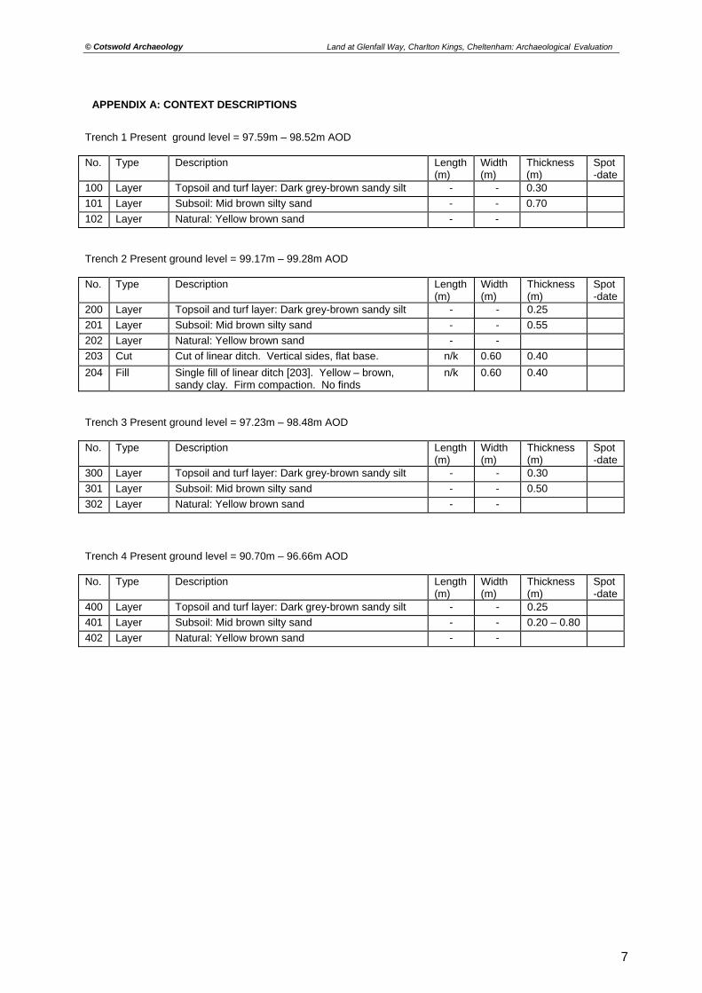
Trench 1 Present ground level = 97.59m – 98.52m AOD No. Type Description Length
(m) Width (m)
Thickness (m)
Spot-date
100 Layer Topsoil and turf layer: Dark grey-brown sandy silt - - 0.30 101 Layer Subsoil: Mid brown silty sand - - 0.70 102 Layer Natural: Yellow brown sand - - Trench 2 Present ground level = 99.17m – 99.28m AOD No. Type Description Length
(m) Width (m)
Thickness (m)
Spot-date
200 Layer Topsoil and turf layer: Dark grey-brown sandy silt - - 0.25 201 Layer Subsoil: Mid brown silty sand - - 0.55 202 Layer Natural: Yellow brown sand - - 203 Cut Cut of linear ditch. Vertical sides, flat base. n/k 0.60 0.40 204 Fill Single fill of linear ditch [203]. Yellow – brown,
sandy clay. Firm compaction. No finds n/k 0.60 0.40
Trench 3 Present ground level = 97.23m – 98.48m AOD No. Type Description Length
(m) Width (m)
Thickness (m)
Spot-date
300 Layer Topsoil and turf layer: Dark grey-brown sandy silt - - 0.30 301 Layer Subsoil: Mid brown silty sand - - 0.50 302 Layer Natural: Yellow brown sand - - Trench 4 Present ground level = 90.70m – 96.66m AOD No. Type Description Length
(m) Width (m)
Thickness (m)
Spot-date
400 Layer Topsoil and turf layer: Dark grey-brown sandy silt - - 0.25 401 Layer Subsoil: Mid brown silty sand - - 0.20 – 0.80 402 Layer Natural: Yellow brown sand - -
7
© Cotswold Archaeology Land at Glenfall Way, Charlton Kings, Cheltenham: Archaeological Evaluation
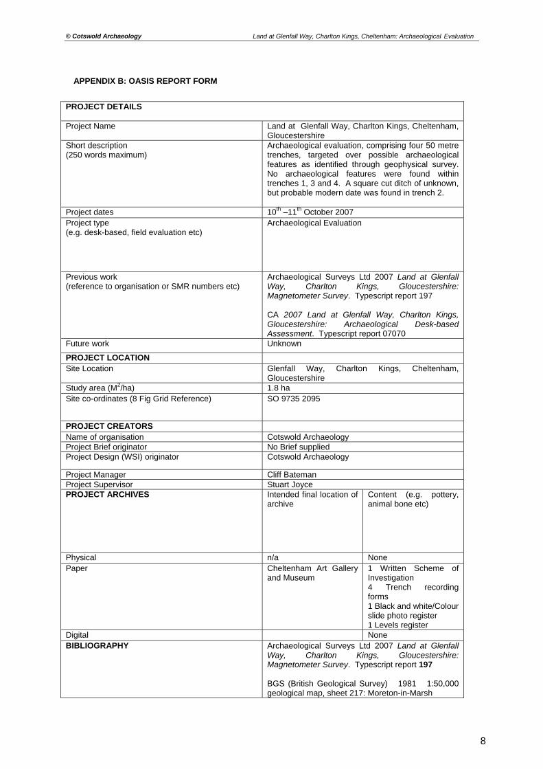
APPENDIX B: OASIS REPORT FORM
PROJECT DETAILS Project Name Land at Glenfall Way, Charlton Kings, Cheltenham,
Gloucestershire Short description (250 words maximum)
Archaeological evaluation, comprising four 50 metre trenches, targeted over possible archaeological features as identified through geophysical survey. No archaeological features were found within trenches 1, 3 and 4. A square cut ditch of unknown, but probable modern date was found in trench 2.
Project dates 10th –11th October 2007 Project type (e.g. desk-based, field evaluation etc)
Archaeological Evaluation
Previous work (reference to organisation or SMR numbers etc)
Archaeological Surveys Ltd 2007 Land at Glenfall Way, Charlton Kings, Gloucestershire: Magnetometer Survey. Typescript report 197 CA 2007 Land at Glenfall Way, Charlton Kings, Gloucestershire: Archaeological Desk-based Assessment. Typescript report 07070
Future work Unknown
PROJECT LOCATION Site Location Glenfall Way, Charlton Kings, Cheltenham,
Gloucestershire Study area (M2/ha) 1.8 ha Site co-ordinates (8 Fig Grid Reference) SO 9735 2095
PROJECT CREATORS Name of organisation Cotswold Archaeology Project Brief originator No Brief supplied Project Design (WSI) originator Cotswold Archaeology
Project Manager Cliff Bateman Project Supervisor Stuart Joyce PROJECT ARCHIVES Intended final location of
archive
Content (e.g. pottery, animal bone etc)
Physical n/a None Paper Cheltenham Art Gallery
and Museum 1 Written Scheme of Investigation 4 Trench recording forms 1 Black and white/Colour slide photo register 1 Levels register
Digital None BIBLIOGRAPHY Archaeological Surveys Ltd 2007 Land at Glenfall
Way, Charlton Kings, Gloucestershire: Magnetometer Survey. Typescript report 197 BGS (British Geological Survey) 1981 1:50,000 geological map, sheet 217: Moreton-in-Marsh
8

© Cotswold Archaeology Land at Glenfall Way, Charlton Kings, Cheltenham: Archaeological Evaluation
CA 2007a Land at Glenfall Way, Charlton Kings, Gloucestershire: Written Scheme of investigation for an Archaeological Evaluation. CA 2007b Land at Glenfall Way, Charlton Kings, Gloucestershire: Archaeological Desk-based Assessment. Typescript report 07070
9
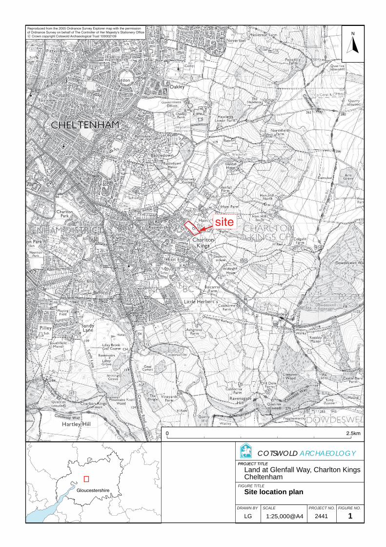
Gloucestershire
PROJECT TITLE
FIGURE TITLE
N
PROJECT TITLE
SCALEDRAWN BY PROJECT NO. FIGURE NO.
COTSWOLD ARCHAEOLOGY
0 2.5km
site
Reproduced from the 2005 Ordnance Survey Explorer map with the permissionof Ordnance Survey on behalf of The Controller of Her Majesty's Stationery Office Crown copyright Cotswold Archaeological Trust 100002109 c
Land at Glenfall Way, Charlton KingsCheltenham
Site location plan
1:25,000@A4 2441LG 1