Embed Size (px)
Citation preview
0 | P a g e
M/s AMODA IRON & STEEL LIMITED
(Colour Granite Quarry – 6.030 Ha.)
Sy. No: 79 of Kambadur (V), Kambadur (M),
Ananthapur District, Andhra Pradesh.
ENVIRONMENTAL MANAGEMENT PLAN
1 | P a g e
INDEX
S. NO PAGE NO
1 INTRODUCTION 2
2 DETAILS ABOUT THE PROPOSED QUARRY SITE 3
3 MINING ACTIVITY 7
4 ENVIRONMENTAL MANAGEMENT PLAN 17
5 COST FOR ENVIRONEMTAL MANAGEMENT 23
2 | P a g e
1.0 INTRODUCTION
M/s AMODA IRON & STEEL LIMITED, Director: Sri T. Satish Kumar, Hyderabad, applied for grant of
quarry lease for Colour Granite over an extent of 6.030 Hectares in Sy. No. 79 of Kambadur Village,
Kambadur Mandal, Ananthapur District, Andhra Pradesh State.
The Asst. Director of Mines and Geology, Ananthapur, submitted the proposals through Zonal Joint
Director of Mines and Geology, Kadapa, proposing for grant of quarry lease for Colour Granite over
an extent of 6.030 Ha. in Sy. No. 79 of Kambadur Village, Kambadur Mandal, Ananthapur District,
Andhra Pradesh State, in favour of M/s AMODA IRON & STEEL LIMITED.
After careful examination of the proposals of the Assistant Director of Mines and Geology,
Ananthapur and Zonal Joint Director of Mines and Geology, Kadapa, the Director, Mines & Geology,
Hyderabad, in principle has decided to grant the quarry lease for Colour Granite over an extent of
6.030 Hectares in Sy. No. 79 of Kambadur Village, Kambadur Mandal, Ananthapur District, Andhra
Pradesh State, in favour of M/s AMODA IRON & STEEL LIMITED, for a period of (20) years
PROFILE OF THE PROJECT PROPONENT
The Applicant of this company is having enough experience to undertake the mining. However the
quarry will be undertaken under the supervision of well experienced Mining Engineer.
BRIEF DESCRIPTION OF THE PROPOSED MINING ACTIVITY
NATURE
This project involves quarrying of Colour granite. This mineral will be quarried by open cast other
than fully mechanized Semi-mechanized
SIZE OF THE PROJECT
Proposed capacity of granite Production will be Max. of 21,244.50 m3 Per Annum in ML Area of
6.030 Hectares in Sy. No. 79 of Kambadur Village, Kambadur Mandal, Ananthapur District, Andhra
Pradesh State. The proposed project cost is Rs. 125 Lakhs.
3 | P a g e
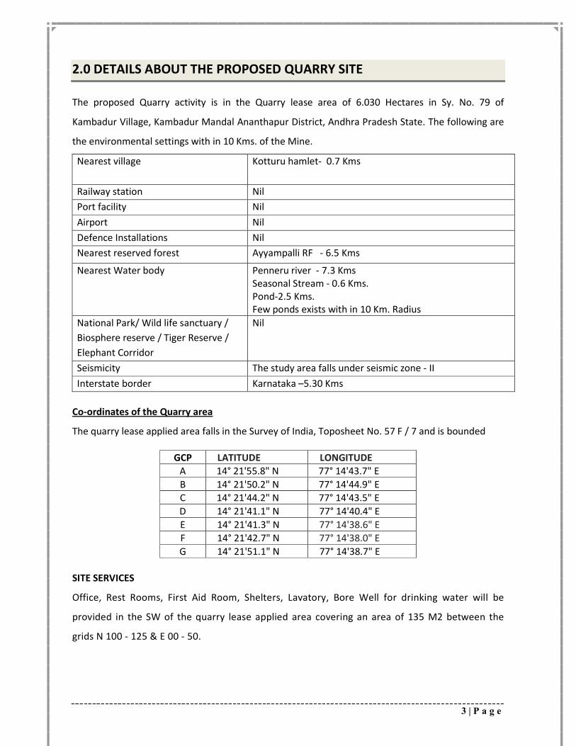
2.0 DETAILS ABOUT THE PROPOSED QUARRY SITE
The proposed Quarry activity is in the Quarry lease area of 6.030 Hectares in Sy. No. 79 of
Kambadur Village, Kambadur Mandal Ananthapur District, Andhra Pradesh State. The following are
the environmental settings with in 10 Kms. of the Mine.
Nearest village Kotturu hamlet- 0.7 Kms
Railway station Nil
Port facility Nil
Airport Nil
Defence Installations Nil
Nearest reserved forest Ayyampalli RF - 6.5 Kms
Nearest Water body Penneru river - 7.3 Kms Seasonal Stream - 0.6 Kms. Pond-2.5 Kms. Few ponds exists with in 10 Km. Radius
National Park/ Wild life sanctuary /
Biosphere reserve / Tiger Reserve /
Elephant Corridor
Nil
Seismicity The study area falls under seismic zone - II
Interstate border Karnataka –5.30 Kms
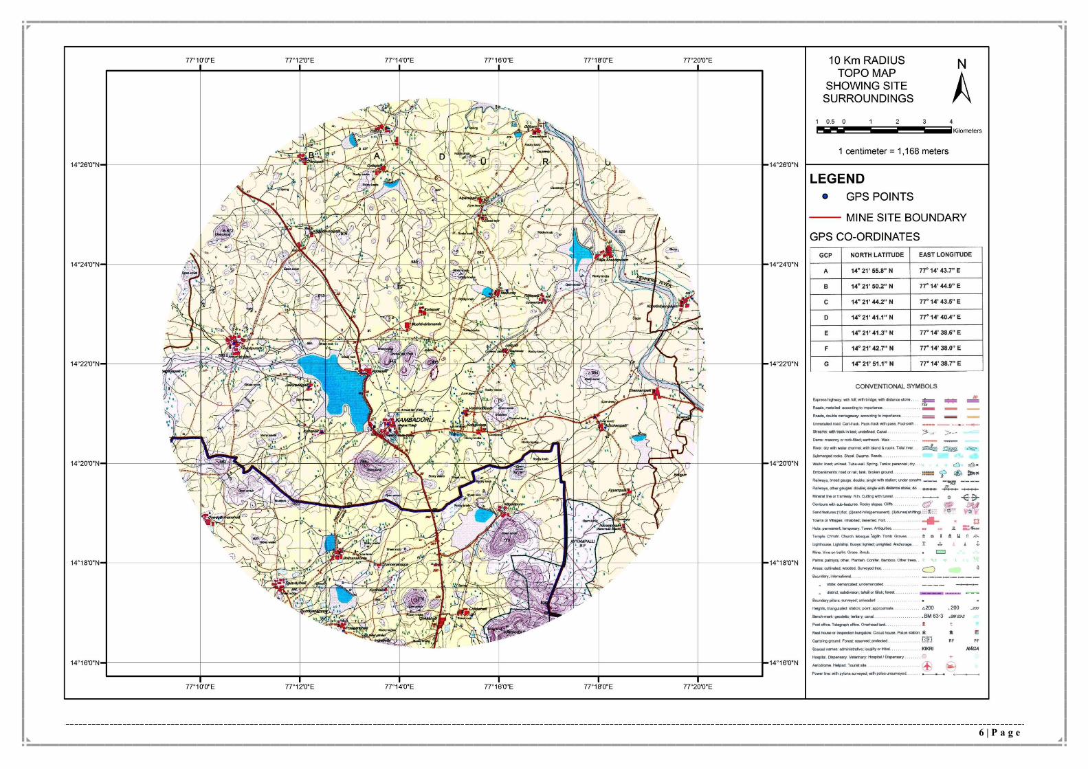
Co-ordinates of the Quarry area
The quarry lease applied area falls in the Survey of India, Toposheet No. 57 F / 7 and is bounded
GCP LATITUDE LONGITUDE
A 14° 21'55.8" N 77° 14'43.7" E
B 14° 21'50.2" N 77° 14'44.9" E
C 14° 21'44.2" N 77° 14'43.5" E
D 14° 21'41.1" N 77° 14'40.4" E
E 14° 21'41.3" N 77° 14'38.6" E
F 14° 21'42.7" N 77° 14'38.0" E
G 14° 21'51.1" N 77° 14'38.7" E
SITE SERVICES
Office, Rest Rooms, First Aid Room, Shelters, Lavatory, Bore Well for drinking water will be
provided in the SW of the quarry lease applied area covering an area of 135 M2 between the
grids N 100 - 125 & E 00 - 50.
4 | P a g e
GEOLOGY OF THE AREA
Regional Geology:
The quarry lease applied area constitutes a part of Granite and Granitic Gneissic terrain of Archean
age. Pink and Grey Coloured Granites, Pink Alkali - Feldspar Granites are the important litho units in
the area. Grano - Diorites with basic enclaves of Supra - Crystals like Horneblende Schists, Biotite
Schists also occupy the area. These rock types are exhibiting various landforms like Domes,
Inselbergs, Castle -Koppies, Whalebacks and Linear Ridges.
The geological succession of the area as worked out by GSI (1991) is as follows:
RECENT ALLUVIUM / SOIL COVER
Younger Quartz Veins, Pegmatites Dolerites, Gabbro, Pyroxenite Dykes Fine Grained Pink Alkali Feldspar Granite, Medium to Coarse Grained Pink Alkali Feldspar Granite Granite With Mega Crysts of K-Feldspar, very coarse grained Pink Alkali Feldspar Granite
Precambrian Granitiod - Migmatite Complex
Medium to Coarse Grained Pink Granite Migmatite II Fine grained Grey Alkali Feldspar Granite Medium to Coarse Grained Grey Alkali Feldspar Granite Very Coarse - Grained Grey Alkali Feldspar Granite Migmatite I Grano - Diorite
Pink Alkali Feldspar is the most dominant rock type in the area with variations in grain size,
scattered outcrops of Migmatites containing Neosomes of medium to Coarse - Grained Grey Alkali
Feldspar Granites occurs at many places. A number of Quartz, grey and pink pegmatities and
epidote veins criss are crossing the host rock. Basic dykes of Dolerite, Gabbro & pyroxenitic
Composition traverse the granites in NW-SE, NNW-ESS,& NE-SW directions. Thin veneer of alluvium
is found limited to streams.
Geology of the area
Entire quarry lease applied area is covered with colour granite which is rising upto 30 M above
ground level, the strike length of the body measured 451 M in the area with an average width of 134
M.
Three sets of joints are recorded in the formation
1. N - S Vertical
2. E-W Vertical
5 | P a g e
3. Horizontal / Sheet Joints
Regionally the area constitute a part of Peninsular Gneissic complex of Achaean, and occupied by
Grey granite, white, grey and pink colour alaskitic granite, with patches of amphibolites,
hornblende schist bonded magnetite quartzites as enclaves in both grey and alaskitic granite.
The major litho units are extensively invaded by younger quartz, pegmatite, epitode, calcite
veins and also by dykes basic rocks.
The grey granite along with intermixing of pink alaskitic granitie forming as mounds, ridges
and hillocks in the area; contact of the rocks clearly indicate intrusive relationship, young
alaskites intruded into older grey granite; which is locally showing poorly developed foliation
trending NW - SE.
The older basic enclaves of amphibolites hornblende schist show signs of metasomatism in the
form of flakes of biotitic. Number of acidic veins like pegmatite, quartz is traversing the grey
granite trending in NNE - SSW. NE - SW to NNW - SSE to NW - SE.
PHYSIOGRAPHY
The quarry lease applied area forms a southern part of the hill, sloping due South. It is about 55
M above ground level within the quarry lease applied area. The drainage network is due South &
SW..
Topography
The quarry lease applied area is a part of hill raised 25 M above ground level with topo relief in
West and East direction. The lowest contour is 520 M and highest contour is 545 M in topo
plan.
6 | P a g e
7 | P a g e
3.0 MINING ACTIVITY
INTRODUCTION
Granite Quarry lease, over an extent 6.030 Hectares in Sy. No. 79 of Kambadur Village, Kambadur
Mandal,, Ananthapur District, Andhra Pradesh State, in favour of Amoda Iron & Steel Limited is
applied to Department of Mines & Geology, Hyderabad.
LOCATION AND ACCESSIBILITY:
a) Details of the Area:
District
State
Village Mandal Sy. No. Extent
(Hectares)
Ownership of
Occupancy
Ananthapur Andhra
Pradesh
Kambadur Kambadur 79 6.030 ha Govt. Land
The area is located in Survey of India Topo Sheet No. 57 F / 7
b) Infrastructure and Communication:
Availability of Water The ground water is available 30 M BGL. The agricultural fields in
the surrounds of the quarry lease applied area are irrigated by
ground water.
Availability of Electricity Electricity is available in all the villages and in the nearby
agricultural lands for borewells.
Communication Network
Tele Communications facility is available at the Kambadur village
Road Network State Transport Bus Services ply from Penukonda - Kalyanadurga
frequently; Private Transport is also available on this road network
Nearest Rail Head Nearest Rail Head is located at Penukonda which is located at the
distance of 70 Kms.
Port Facility Krishnapatnam Port is about 440 Km from area
School Primary School Education is available at Kambadur Mandal Head
Quarters. Higher Education is available at Penukonda, Ananthapur
& Bellary
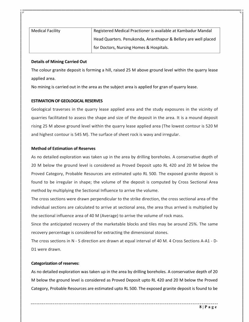
8 | P a g e
Medical Facility Registered Medical Practioner is available at Kambadur Mandal
Head Quarters. Penukonda, Ananthapur & Bellary are well placed
for Doctors, Nursing Homes & Hospitals.
Details of Mining Carried Out
The colour granite deposit is forming a hill, raised 25 M above ground level within the quarry lease
applied area.
No mining is carried out in the area as the subject area is applied for gran of quarry lease.
ESTIMATION OF GEOLOGICAL RESERVES
Geological traverses in the quarry lease applied area and the study exposures in the vicinity of
quarries facilitated to assess the shape and size of the deposit in the area. It is a mound deposit
rising 25 M above ground level within the quarry lease applied area (The lowest contour is 520 M
and highest contour is 545 M). The surface of sheet rock is wavy and irregular.
Method of Estimation of Reserves
As no detailed exploration was taken up in the area by drilling boreholes. A conservative depth of
20 M below the ground level is considered as Proved Deposit upto RL 420 and 20 M below the
Proved Category, Probable Resources are estimated upto RL 500. The exposed granite deposit is
found to be irregular in shape; the volume of the deposit is computed by Cross Sectional Area
method by multiplying the Sectional Influence to arrive the volume.
The cross sections were drawn perpendicular to the strike direction, the cross sectional area of the
individual sections are calculated to arrive at sectional area, the area thus arrived is multiplied by
the sectional influence area of 40 M (Average) to arrive the volume of rock mass.
Since the anticipated recovery of the marketable blocks and tiles may be around 25%. The same
recovery percentage is considered for extracting the dimensional stones.
The cross sections in N - S direction are drawn at equal interval of 40 M. 4 Cross Sections A-A1 - D-
D1 were drawn.
Categorization of reserves:
As no detailed exploration was taken up in the area by drilling boreholes. A conservative depth of 20
M below the ground level is considered as Proved Deposit upto RL 420 and 20 M below the Proved
Category, Probable Resources are estimated upto RL 500. The exposed granite deposit is found to be
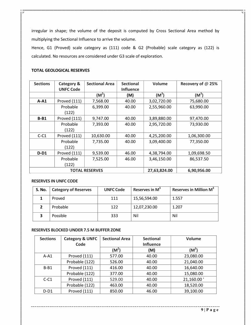
9 | P a g e
irregular in shape; the volume of the deposit is computed by Cross Sectional Area method by
multiplying the Sectional Influence to arrive the volume.
Hence, G1 (Proved) scale category as (111) code & G2 (Probable) scale category as (122) is
calculated. No resources are considered under G3 scale of exploration.
TOTAL GEOLOGICAL RESERVES
Sections Category & UNFC Code
Sectional Area Sectional Influence
Volume Recovery of @ 25%
(M2) (M) (M3) (M3)
A-A1 Proved (111) 7,568.00 40.00 3,02,720.00 75,680.00
Probable (122)
6,399.00 40.00 2,55,960.00 63,990.00
B-B1 Proved (111) 9,747.00 40.00 3,89,880.00 97,470.00
Probable (122)
7,393.00 40.00 2,95,720.00 73,930.00
C-C1 Proved (111) 10,630.00 40.00 4,25,200.00 1,06,300.00
Probable (122)
7,735.00 40.00 3,09,400.00 77,350.00
D-D1 Proved (111) 9,539.00 46.00 4,38,794.00 1,09,698.50
Probable (122)
7,525.00 46.00 3,46,150.00 86,537.50
TOTAL RESERVES 27,63,824.00 6,90,956.00
RESERVES IN UNFC CODE
S. No. Category of Reserves UNFC Code Reserves in M3 Reserves in Million M3
1 Proved 111 15,56,594.00 1.557
2 Probable 122 12,07,230.00 1.207
3 Possible 333 Nil Nil
RESERVES BLOCKED UNDER 7.5 M BUFFER ZONE
Sections
Category & UNFC Code
Sectional Area Sectional Influence
Volume
(M2) (M) (M3)
A-A1 Proved (111) 577.00 40.00 23,080.00
Probable (122) 526.00 40.00 21,040.00
B-B1 Proved (111) 416.00 40.00 16,640.00
Probable (122) 377.00 40.00 15,080.00
C-C1 Proved (111) 529.00 40.00 21,160.00 '
Probable (122) 463.00 40.00 18,520.00
D-D1 Proved (111) 850.00 46.00 39,100.00
10 | P a g e
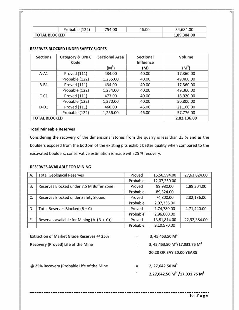
Probable (122) 754.00 46.00 34,684.00
TOTAL BLOCKED 1,89,304.00
RESERVES BLOCKED UNDER SAFETY SLOPES
Sections Category & UNFC Code
Sectional Area Sectional Influence
Volume
(M2) (M) (M3)
A-A1 Proved (111) 434.00 40.00 17,360.00
Probable (122) 1,235.00 40.00 49,400.00
B-B1 Proved (111) 434.00 40.00 17,360.00
Probable (122) 1,234.00 40.00 49,360.00
C-C1 Proved (111) 473.00 40.00 18,920.00
Probable (122) 1,270.00 40.00 50,800.00
D-D1 Proved (111) 460.00 46.00 21,160.00
Probable (122) 1,256.00 46.00 57,776.00
TOTAL BLOCKED 2,82,136.00
Total Mineable Reserves
Considering the recovery of the dimensional stones from the quarry is less than 25 % and as the
boulders exposed from the bottom of the existing pits exhibit better quality when compared to the
excavated boulders, conservative estimation is made with 25 % recovery.
RESERVES AVAILABLE FOR MINING
A. Total Geological Reserves Proved 15,56,594.00 27,63,824.00
Probable 12,07,230.00
B. Reserves Blocked under 7.5 M Buffer Zone Proved 99,980.00 1,89,304.00
Probable 89,324.00
C. Reserves Blocked under Safety Slopes Proved 74,800.00 2,82,136.00
Probable 2,07,336.00
D. Total Reserves Blocked (B + C) Proved 1,74,780.00 4,71,440.00
Probable 2,96,660.00
E. Reserves available for Mining (A-(B + C)) Proved 13,81,814.00 22,92,384.00
Probable 9,10,570.00
Extraction of Market Grade Reserves @ 25% = 3, 45,453.50 M3
Recovery (Proved) Life of the Mine = 3, 45,453.50 M3/17,031.75 M3
20.28 OR SAY 20.00 YEARS
@ 25% Recovery (Probable Life of the Mine = 2, 27,642.50 M3
= 2,27,642.50 M3 /17,031.75 M3
11 | P a g e
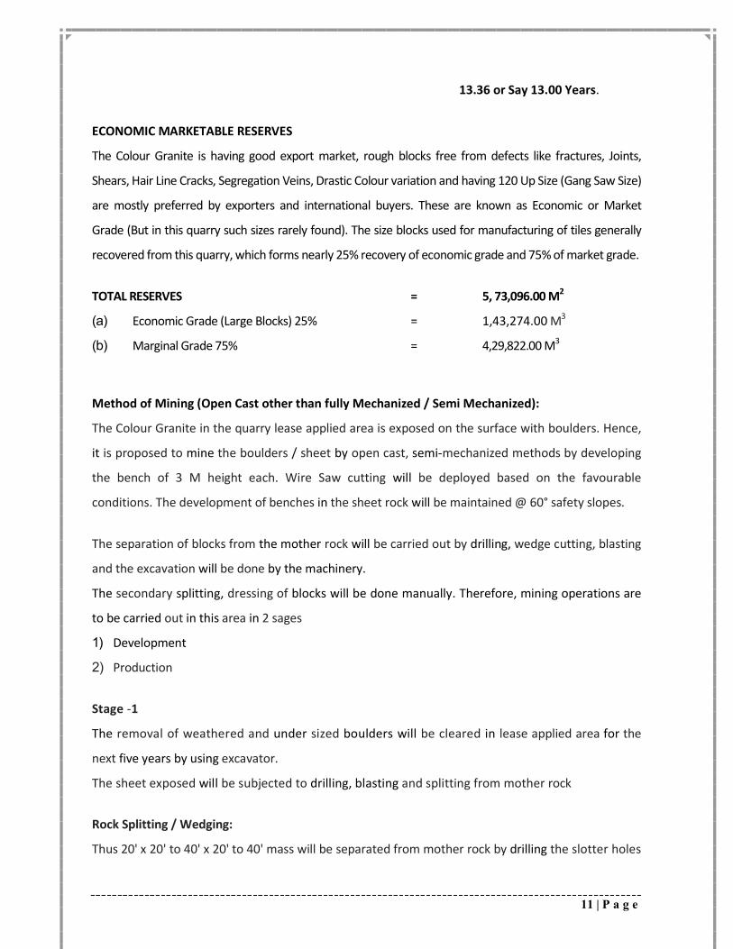
13.36 or Say 13.00 Years.
ECONOMIC MARKETABLE RESERVES
The Colour Granite is having good export market, rough blocks free from defects like fractures, Joints,
Shears, Hair Line Cracks, Segregation Veins, Drastic Colour variation and having 120 Up Size (Gang Saw Size)
are mostly preferred by exporters and international buyers. These are known as Economic or Market
Grade (But in this quarry such sizes rarely found). The size blocks used for manufacturing of tiles generally
recovered from this quarry, which forms nearly 25% recovery of economic grade and 75% of market grade.
TOTAL RESERVES = 5, 73,096.00 M2
(a) Economic Grade (Large Blocks) 25% = 1,43,274.00 M3
(b) Marginal Grade 75% = 4,29,822.00 M3
Method of Mining (Open Cast other than fully Mechanized / Semi Mechanized):
The Colour Granite in the quarry lease applied area is exposed on the surface with boulders. Hence,
it is proposed to mine the boulders / sheet by open cast, semi-mechanized methods by developing
the bench of 3 M height each. Wire Saw cutting will be deployed based on the favourable
conditions. The development of benches in the sheet rock will be maintained @ 60° safety slopes.
The separation of blocks from the mother rock will be carried out by drilling, wedge cutting, blasting
and the excavation will be done by the machinery.
The secondary splitting, dressing of blocks will be done manually. Therefore, mining operations are
to be carried out in this area in 2 sages
1) Development
2) Production
Stage -1
The removal of weathered and under sized boulders will be cleared in lease applied area for the
next five years by using excavator.
The sheet exposed will be subjected to drilling, blasting and splitting from mother rock
Rock Splitting / Wedging:
Thus 20' x 20' to 40' x 20' to 40' mass will be separated from mother rock by drilling the slotter holes
12 | P a g e
on both sides of the mass and a top hole intersecting these two holes and wiresaw rope is passed
through and cutting is done horizontally and vertically and by this there will be mass opening on all
the sides from the mother mass.
Stage - 2
After removal of weathered and under sized boulders.
• The sheet exposed will be subjected to splitting into required sizes of blocks by using Jack
Hammers by drilling series of deep holes at right angles at regular intervals, later by
inserting feather and wedges in these holes and hammering with sledge hammer will release
the blocks.
• The boulders will be splitted to the required sizes with drilling and if required by
using chemical compound at the source only. The boulders separated will be
brought to the dressing yard for dressing.
• If the boulders, which fit into the required market grade size will be transformed into
cuboids.
Secondary Splitting:
After separation from the mother rock, it is properly checked by washing with water to identify
defects and cracks. Based on this observation, the size is decided and the blocks are marked and
separated by drilling and wedging.
The separated pieces will be examined for defects and lines, then the block or blocks are marked in
clear area and holes are drilled along the line of marking, with the help of feathers and wedges and
the waste portions are separated forming a rectangular blocks. Any bulges will be removed by
drilling and wedging making it perfect blocks. A perfect block is that all the sides shall make with
each other 90°.
Dressing
i) Dressing of dimensional rough blocks for export:
Dressing is final phase of mining operation, wherein the secondary rough blocks are
squared into regular perfect rectangular sizes, thereby avoiding uneven bulge or cavities and
other defects. Jackhammers with compressor, feather end wedges and sledgehammers are
equipments generally used for dressing the block.
13 | P a g e
ii) Dressing of rough blocks for domestic processing plant:
Dressing by means of squaring and splitting will be done for rough blocks of the size varying
between 120 x 90 x 80 and 300 x 200 x 190 M.
iii) The applicant does not possess processing plant
Drilling & Blasting
A) Drill hole pattern for smooth blasting, holes of 3 M depth will be drilled of single
row with spacing of less than 0.3 M and burden of 1.6 M or more shall be maintained
uniformly. This arrangement will yield rock size of 3 M x 2 M cross section. A bench height
of 3.5 M will be tackled.
Drilling Parameters:
i. Drill Hole Diameter 32 MM up to 3 M Long.
ii. Depth and Inclination of Drill Hole: Generally drilled vertically in an alignment,
however in primary cutting in the absence of sheet joints to develop bottom level, horizontal
holes also are drilled.
iii. Spacing and Burden
The spacing shall be about 0.1 M to 0.3 M from hole to hole and burden goes up to 1.6 M for
the splitting of the rock.
iv. Stemming & Charging of Bore Hole
Chemical Powder is used. The blast hole will be charged with 150 Grams of chemical powder by
stemming with smooth strand.
v. Explosive Type: Wherever required chemical compound is used for splitting the rock.
YEAR WISE PRODUCTION FOR THE FIRST 5 YEARS MINING PLAN:
It is proposed to produce 85,158.75 M3 of market grade rough blocks during the plan period with an
average annual production of 17,031.75 M3 from an area of 28,326.00 M2. Bench of 3 M will be
developed during the plan period.
For achieving this production 3, 40,635.00 M3 of Rock Mass will be excavated and 2,55,476.25 M3 of
Waste will be generated.
14 | P a g e
The waste generated will be dumped in the Northern side of the quarry lease applied area (Within
the quarry lease applied area) between the grids N 275 - 425 & E 25 - 225 covering an area of 11,635
M2 with an average height of 30 M with 45° slope angle will be formed. A retaining wall will be
constructed around the dump for preventing the slanting of boulders.
Stack Yard:
The blocks generated will be stocked in the temporary stock yard over an area of 1,301 M2 in the
SW of the quarry lease applied area between the grids N 50 - 75 & E 300 - 75.
Mining Programe for the five years
The applicant proposes to take up quarrying operations between the Sections A-A1 to E-E1 in
the grids N 75 - 275 & E 00 - 225. The mining operations will be initiated from North of the
quarry lease applied area. The mining operations will Eastwards.
1st Year
In the first year mining will be initiated from Center of the quarry lease applied area between the grids
N 75 - 275 & E 00 - 225 covering an area of 28,326.00 M2 a bench of 3 M height will be formed.
The mining advances Eastwards. An area of 28,326.00 M2 will be excavated producing 84,978.00 M3 of
Rock Mass, 25% (21,244.50 M3) of Market Grade Rough Blocks and 75% (63,733.50 M3) of Waste Rock
will be generated.
2nd Year
In the second year the mining will continue below 1st year workings between the grids N 75 - 275 &
E 00 - 225 covering an area of 25,357.00 M2 a bench of 3 M height will be formed.
The mining advances East & Westwards. An area of 25,357.00 M2 will be excavated producing
76,071.00 M3 of Rock Mass, 25% (19,017.75 M3) of Market Grade Rough Blocks and 75% (57,053.25
M3) of Waste Rock will be generated.
3rd Year
In the third year the mining will continue below 2nd year workings between the grids N 75 - 275
& E 00 - 225 covering an area of 22,546.00 M2 a bench of 3 M height will be formed.
The mining advances Eastwards. An area of 22,546.00 M2 will be excavated producing 67,638.00
M3 of Rock Mass, 25% (16,909.50 M3) of Market Grade Rough Blocks and 75% (50,728.50 M3) of
Waste Rock will be generated.
15 | P a g e
4th Year
In the fourth year the mining will continue below 3rd year workings between the grids N 75 - 275
& E 00 - 225 covering an area of 19,899.00 M2 a bench of 3 M height will be formed.
The mining advances Eastwards. An area of 19,899.00 M2 will be excavated producing 59,697.00
M3 of Rock Mass, 25% (14,924.25 M3) of Market Grade Rough Blocks and 75% (44,772.75 M3) of
Waste Rock will be generated.
5th Year
In the fifth year the mining will continue below 4th year workings between the grids N 75 - 275
& E 00 - 225 covering an area of 17,417.00 M2 a bench of 3 M height will be formed.
The mining advances Eastwards. An area of 17,417.00 M2 will be excavated producing
52,251.00 M3 of Rock Mass, 25% (13,062.75 M3) of Market Grade Rough Blocks and75%
(39,188.25 M3) of Waste Rock will be generated.
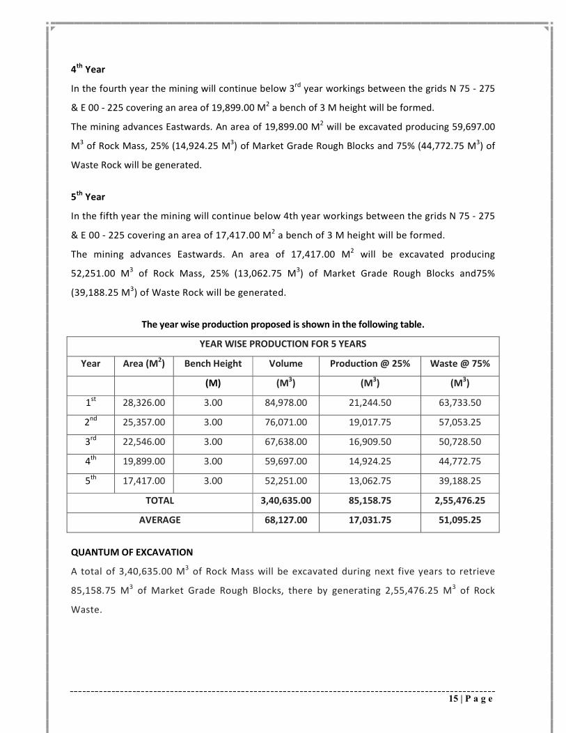
The year wise production proposed is shown in the following table.
YEAR WISE PRODUCTION FOR 5 YEARS
Year Area (M2) Bench Height Volume Production @ 25% Waste @ 75%
(M) (M3) (M3) (M3)
1st 28,326.00 3.00 84,978.00 21,244.50 63,733.50
2nd 25,357.00 3.00 76,071.00 19,017.75 57,053.25
3rd 22,546.00 3.00 67,638.00 16,909.50 50,728.50
4th 19,899.00 3.00 59,697.00 14,924.25 44,772.75
5th 17,417.00 3.00 52,251.00 13,062.75 39,188.25
TOTAL 3,40,635.00 85,158.75 2,55,476.25
AVERAGE 68,127.00 17,031.75 51,095.25
QUANTUM OF EXCAVATION
A total of 3,40,635.00 M3 of Rock Mass will be excavated during next five years to retrieve
85,158.75 M3 of Market Grade Rough Blocks, there by generating 2,55,476.25 M3 of Rock
Waste.
16 | P a g e
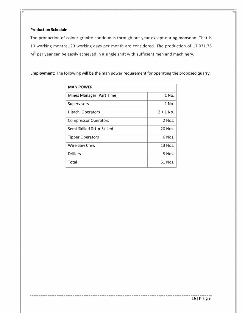
Production Schedule
The production of colour granite continuous through out year except during monsoon. That is
10 working months, 20 working days per month are considered. The production of 17,031.75
M3 per year can be easily achieved in a single shift with sufficient men and machinery.
Employment: The following will be the man power requirement for operating the proposed quarry.
MAN POWER
Mines Manager (Part Time) 1 No.
Supervisors 1 No.
Hitachi Operators 2 + 1 No.
Compressor Operators 2 Nos.
Semi-Skilled & Un-Skilled 20 Nos.
Tipper Operators 6 Nos.
Wire Saw Crew 13 Nos.
Drillers 5 Nos.
Total 51 Nos.
17 | P a g e
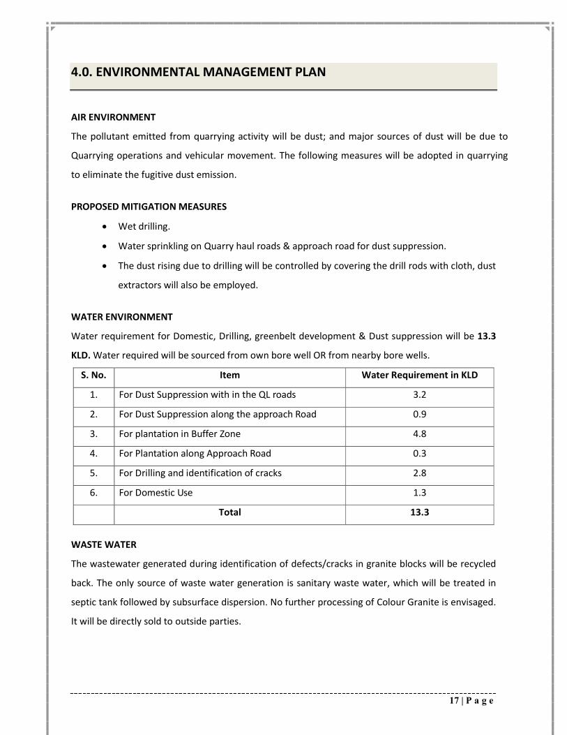
4.0. ENVIRONMENTAL MANAGEMENT PLAN
AIR ENVIRONMENT
The pollutant emitted from quarrying activity will be dust; and major sources of dust will be due to
Quarrying operations and vehicular movement. The following measures will be adopted in quarrying
to eliminate the fugitive dust emission.
PROPOSED MITIGATION MEASURES
Wet drilling.
Water sprinkling on Quarry haul roads & approach road for dust suppression.
The dust rising due to drilling will be controlled by covering the drill rods with cloth, dust
extractors will also be employed.
WATER ENVIRONMENT
Water requirement for Domestic, Drilling, greenbelt development & Dust suppression will be 13.3
KLD. Water required will be sourced from own bore well OR from nearby bore wells.
S. No. Item Water Requirement in KLD
1. For Dust Suppression with in the QL roads 3.2
2. For Dust Suppression along the approach Road 0.9
3. For plantation in Buffer Zone 4.8
4. For Plantation along Approach Road 0.3
5. For Drilling and identification of cracks 2.8
6. For Domestic Use 1.3
Total 13.3
WASTE WATER
The wastewater generated during identification of defects/cracks in granite blocks will be recycled
back. The only source of waste water generation is sanitary waste water, which will be treated in
septic tank followed by subsurface dispersion. No further processing of Colour Granite is envisaged.
It will be directly sold to outside parties.
18 | P a g e
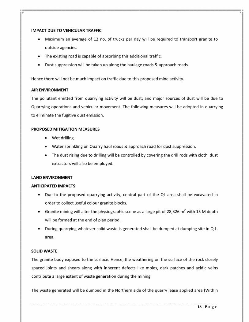
IMPACT DUE TO VEHICULAR TRAFFIC
Maximum an average of 12 no. of trucks per day will be required to transport granite to
outside agencies.
The existing road is capable of absorbing this additional traffic.
Dust suppression will be taken up along the haulage roads & approach roads.
Hence there will not be much impact on traffic due to this proposed mine activity. AIR ENVIRONMENT
The pollutant emitted from quarrying activity will be dust; and major sources of dust will be due to
Quarrying operations and vehicular movement. The following measures will be adopted in quarrying
to eliminate the fugitive dust emission.
PROPOSED MITIGATION MEASURES
Wet drilling.
Water sprinkling on Quarry haul roads & approach road for dust suppression.
The dust rising due to drilling will be controlled by covering the drill rods with cloth, dust
extractors will also be employed.
LAND ENVIRONMENT
ANTICIPATED IMPACTS
Due to the proposed quarrying activity, central part of the QL area shall be excavated in
order to collect useful colour granite blocks.
Granite mining will alter the physiographic scene as a large pit of 28,326 m2 with 15 M depth
will be formed at the end of plan period.
During quarrying whatever solid waste is generated shall be dumped at dumping site in Q.L.
area.
SOLID WASTE
The granite body exposed to the surface. Hence, the weathering on the surface of the rock closely
spaced joints and shears along with inherent defects like moles, dark patches and acidic veins
contribute a large extent of waste generation during the mining.
The waste generated will be dumped in the Northern side of the quarry lease applied area (Within
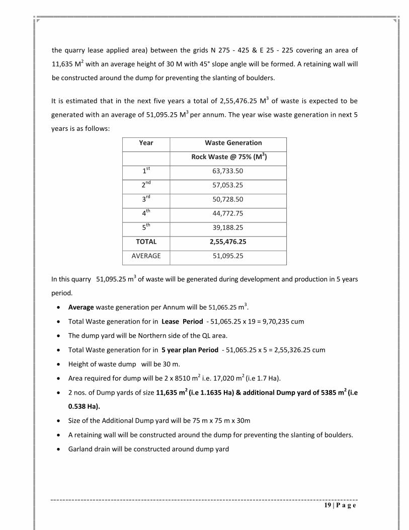
19 | P a g e
the quarry lease applied area) between the grids N 275 - 425 & E 25 - 225 covering an area of
11,635 M2 with an average height of 30 M with 45° slope angle will be formed. A retaining wall will
be constructed around the dump for preventing the slanting of boulders.
It is estimated that in the next five years a total of 2,55,476.25 M3 of waste is expected to be
generated with an average of 51,095.25 M3 per annum. The year wise waste generation in next 5
years is as follows:
Year Waste Generation
Rock Waste @ 75% (M3)
1st 63,733.50
2nd 57,053.25
3rd 50,728.50
4th 44,772.75
5th 39,188.25
TOTAL 2,55,476.25
AVERAGE 51,095.25
In this quarry 51,095.25 m3 of waste will be generated during development and production in 5 years
period.
Average waste generation per Annum will be 51,065.25 m3.
Total Waste generation for in Lease Period - 51,065.25 x 19 = 9,70,235 cum
The dump yard will be Northern side of the QL area.
Total Waste generation for in 5 year plan Period - 51,065.25 x 5 = 2,55,326.25 cum
Height of waste dump will be 30 m.
Area required for dump will be 2 x 8510 m2 i.e. 17,020 m2 (i.e 1.7 Ha).
2 nos. of Dump yards of size 11,635 m2 (i.e 1.1635 Ha) & additional Dump yard of 5385 m2 (i.e
0.538 Ha).
Size of the Additional Dump yard will be 75 m x 75 m x 30m
A retaining wall will be constructed around the dump for preventing the slanting of boulders.
Garland drain will be constructed around dump yard
20 | P a g e
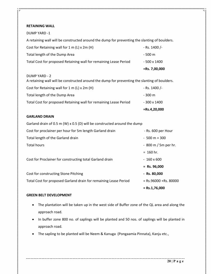
RETAINING WALL
DUMP YARD -1
A retaining wall will be constructed around the dump for preventing the slanting of boulders.
Cost for Retaining wall for 1 m (L) x 2m (H) - Rs. 1400 /-
Total length of the Dump Area - 500 m
Total Cost for proposed Retaining wall for remaining Lease Period - 500 x 1400
=Rs. 7,00,000
DUMP YARD - 2 A retaining wall will be constructed around the dump for preventing the slanting of boulders.
Cost for Retaining wall for 1 m (L) x 2m (H) - Rs. 1400 /-
Total length of the Dump Area - 300 m
Total Cost for proposed Retaining wall for remaining Lease Period - 300 x 1400
=Rs.4,20,000
GARLAND DRAIN
Garland drain of 0.5 m (W) x 0.5 (D) will be constructed around the dump
Cost for proclainer per hour for 5m length Garland drain - Rs. 600 per Hour
Total length of the Garland drain - 500 m + 300
Total hours - 800 m / 5m per hr.
= 160 hr.
Cost for Proclainer for constructing total Garland drain - 160 x 600
= Rs. 96,000
Cost for constructing Stone Pitching - Rs. 80,000
Total Cost for proposed Garland drain for remaining Lease Period = Rs.96000 +Rs. 80000
= Rs.1,76,000
GREEN BELT DEVELOPMENT
The plantation will be taken up in the west side of Buffer zone of the QL area and along the
approach road.
In buffer zone 800 no. of saplings will be planted and 50 nos. of saplings will be planted in
approach road.
The sapling to be planted will be Neem & Kanuga (Pongaamia Pinnata), Kanju etc.,
21 | P a g e
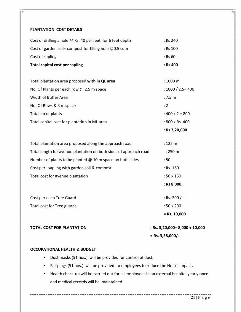
PLANTATION COST DETAILS Cost of drilling a hole @ Rs. 40 per feet for 6 feet depth : Rs 240
Cost of garden soil+ compost for filling hole @0.5 cum : Rs 100
Cost of sapling : Rs 60
Total capital cost per sapling : Rs 400
Total plantation area proposed with in QL area : 1000 m
No. Of Plants per each row @ 2.5 m space : 1000 / 2.5= 400
Width of Buffer Area : 7.5 m
No. Of Rows & 3 m space : 2
Total no of plants : 400 x 2 = 800
Total capital cost for plantation in ML area : 800 x Rs. 400
: Rs 3,20,000
Total plantation area proposed along the approach road : 125 m
Total length for avenue plantation on both sides of approach road : 250 m
Number of plants to be planted @ 10 m space on both sides : 50
Cost per sapling with garden soil & compost : Rs. 160
Total cost for avenue plantation : 50 x 160
: Rs 8,000
Cost per each Tree Guard : Rs. 200 /-
Total cost for Tree guards : 50 x 200
= Rs. 10,000
TOTAL COST FOR PLANTATION : Rs. 3,20,000+ 8,000 + 10,000
= Rs. 3,38,000/-
OCCUPATIONAL HEALTH & BUDGET
• Dust masks (51 nos.) will be provided for control of dust.
• Ear plugs (51 nos.) will be provided to employees to reduce the Noise impact.
• Health check-up will be carried out for all employees in an external hospital yearly once
and medical records will be maintained
22 | P a g e
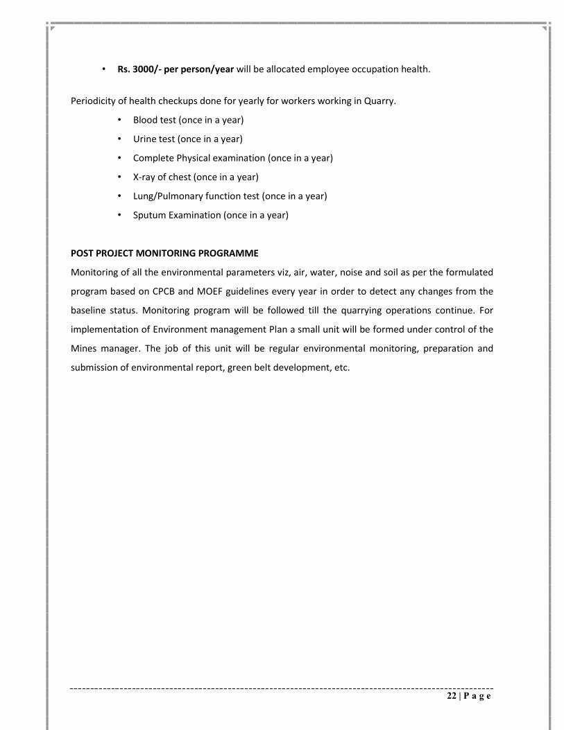
• Rs. 3000/- per person/year will be allocated employee occupation health.
Periodicity of health checkups done for yearly for workers working in Quarry.
• Blood test (once in a year)
• Urine test (once in a year)
• Complete Physical examination (once in a year)
• X-ray of chest (once in a year)
• Lung/Pulmonary function test (once in a year)
• Sputum Examination (once in a year)
POST PROJECT MONITORING PROGRAMME
Monitoring of all the environmental parameters viz, air, water, noise and soil as per the formulated
program based on CPCB and MOEF guidelines every year in order to detect any changes from the
baseline status. Monitoring program will be followed till the quarrying operations continue. For
implementation of Environment management Plan a small unit will be formed under control of the
Mines manager. The job of this unit will be regular environmental monitoring, preparation and
submission of environmental report, green belt development, etc.
23 | P a g e
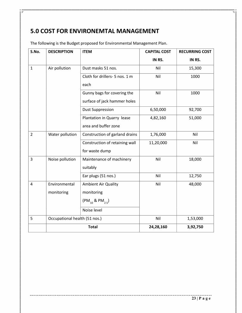
5.0 COST FOR ENVIRONEMTAL MANAGEMENT
The following is the Budget proposed for Environmental Management Plan.
S.No. DESCRIPTION ITEM CAPITAL COST
IN RS.
RECURRING COST
IN RS.
1 Air pollution Dust masks 51 nos. Nil 15,300
Cloth for drillers- 5 nos. 1 m
each
Nil 1000
Gunny bags for covering the
surface of jack hammer holes
Nil 1000
Dust Suppression 6,50,000 92,700
Plantation in Quarry lease
area and buffer zone
4,82,160 51,000
2 Water pollution Construction of garland drains 1,76,000 Nil
Construction of retaining wall
for waste dump
11,20,000 Nil
3 Noise pollution Maintenance of machinery
suitably
Nil 18,000
Ear plugs (51 nos.) Nil 12,750
4 Environmental
monitoring
Ambient Air Quality
monitoring
(PM10
& PM2.5
)
Nil 48,000
Noise level
5 Occupational health (51 nos.) Nil 1,53,000
Total 24,28,160 3,92,750