Embed Size (px)
Citation preview
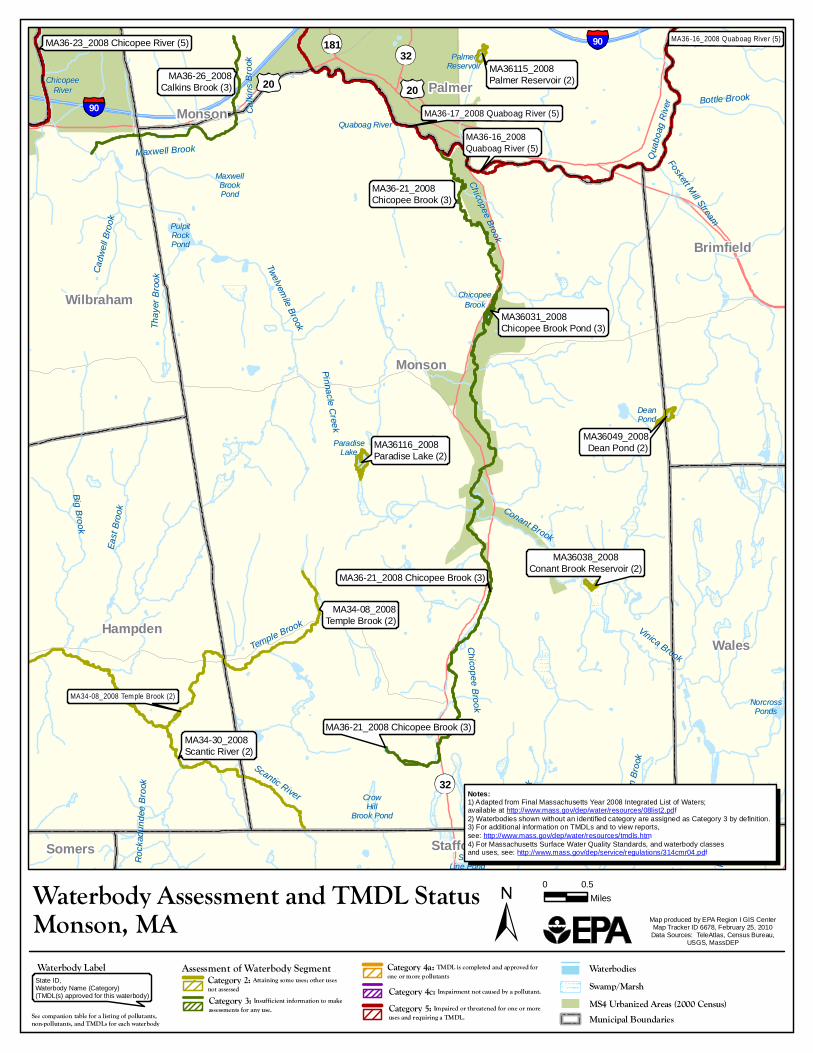
MaxwellMaxwellBrookBrookPondPond
Quaboag RiverQuaboag River
PalmerPalmerReservoirReservoir
ChicopeeChicopeeBrookBrook
StateStateLine PondLine Pond
DeanDeanPondPond
AldenAldenBrook PondBrook Pond
NorcrossNorcrossPondsPonds
ParadiseParadiseLakeLake
CrowCrowHillHill
Brook PondBrook Pond
ChicopeeChicopeeRiverRiver
PulpitPulpitRockRockPondPond
Cadw
ell B
rook
Cadw
ell B
rook
East
Broo
kEa
st Br
ook
Alden
Broo
kAld
en Br
ook
Potas
h Broo
kPo
tash B
rook
Maxwell BrookMaxwell Brook
Conant Brook
Conant Brook
Chicopee BrookChicopee Brook
Scantic River
Scantic River
Temple Brook
Temple Brook
Quab
oag R
iver
Quab
oag R
iver Bottle BrookBottle Brook
Vinica Brook
Vinica Brook
Thay
er Br
ook
Thay
er Br
ook
Calki
ns Br
ook
Calki
ns Br
ook
Foskett Mill Stream
Foskett Mill Stream
Rock
adun
dee B
rook
Rock
adun
dee B
rook
Chicopee Brook
Chicopee Brook
Sawm
ill Broo
k
Sawm
ill Broo
k
Big BrookBig Brook
Twelvemile Brook
Twelvemile Brook
Pinnacle CreekPinnacle Creek
MA36049_2008Dean Pond (2)
MA36031_2008Chicopee Brook Pond (3)
MA36115_2008Palmer Reservoir (2)
MA36116_2008Paradise Lake (2)
MA36038_2008Conant Brook Reservoir (2)
181
32
32
Palmer
Somers Stafford
Hampden
Brimfield
Wilbraham
Wales
Monson
Monson
2020
MA36-17_2008 Quaboag River (5)
MA36-21_2008 Chicopee Brook (3)
MA36-16_2008Quaboag River (5)
MA34-08_2008 Temple Brook (2)
MA36-16_2008 Quaboag River (5)MA36-23_2008 Chicopee River (5)
MA36-21_2008Chicopee Brook (3)
MA36-21_2008 Chicopee Brook (3)
MA36-26_2008Calkins Brook (3)
MA34-08_2008Temple Brook (2)
MA34-30_2008Scantic River (2)
90
90
Waterbody Assessment and TMDL Status 0 0.5Miles
Map produced by EPA Region I GIS CenterMap Tracker ID 6678, February 25, 2010
Data Sources: TeleAtlas, Census Bureau,USGS, MassDEP
Monson, MAWaterbodies
MS4 Urbanized Areas (2000 Census)Municipal Boundaries
Swamp/MarshState ID,Waterbody Name (Category)(TMDL(s) approved for this waterbody)
Waterbody Label Assessment of Waterbody SegmentCategory 2: Attaining some uses; other usesnot assessedCategory 3: Insufficient information to make assessments for any use.See companion table for a listing of pollutants,non-pollutants, and TMDLs for each waterbody
Notes:1) Adapted from Final Massachusetts Year 2008 Integrated List of Waters;available at http://www.mass.gov/dep/water/resources/08list2.pdf2) Waterbodies shown without an identified category are assigned as Category 3 by definition.3) For additional information on TMDLs and to view reports, see: http://www.mass.gov/dep/water/resources/tmdls.htm4) For Massachusetts Surface Water Quality Standards, and waterbody classesand uses, see: http://www.mass.gov/dep/service/regulations/314cmr04.pdf
Category 4a: TMDL is completed and approved for one or more pollutantsCategory 4c: Impairment not caused by a pollutant.Category 5: Impaired or threatened for one or moreuses and requiring a TMDL.

![PDF] List of Integrated Report (IR) Category 4a/b/c WatersList of Integrated Report (IR) Category 4a/b/c Waters – June 2020 Water Index Number Waterbody Name (WI/PWL ID) County Type](https://img.pdfslide.us/doc/110x75/612d65ef1ecc5158694229fc/list-of-integrated-report-ir-category-4abc-waterslist-of-integrated-report-ir.jpg)