Embed Size (px)
Citation preview
MODELING OF WATER QUALITY OF SUNGAI MAONG USING INFORWORKS RIVER SIMULATION SOFrWARE.
Penny Ak Sutnok
MASTER OF ENVIRONMENTAL SCIENCE (LAND USE AND WATER RESOURCE MANAGEMENT)
2007

Pusat KbidmiH . 1a ll"l i ~,u"': ali UI\1¥ERSm MALAYSIA SARAWAK
P,KHIDMAT MAKLUMAT AKADEMII<
111111111 fllfllllllllll ,1000246511
~"\.~~S~
~ ~ ~
\ % I
Faculty of Resource Science and Technology
MODELING OF WATER QUALlTY OF SUNGAI MAONG
USING INFOWORKS RIVER SIMULATION SOFTWARE .
.'
Penny Ak Sumok .
Master of Environmental Science
(Land Use and Water Resource Management)
2007

MODELING OF WATER QUALITY OF SUNGAI MAONG
USING INFOWORKS RIVER SIMULATION SOFTWARE.
PENNY AK SUMOK
A dissertation submitted in fulfillment of the requirements for the
Master of Environmental Science
(Land Use and Water Resource Management)
Faculty of Resource Science and Technology
UNIVERSITY MALAYSIA SARAWAK
2007

ACKNOWLEDGEMENT
I would like to personally give thanks and appreciation to my supervisor, Prof.
Salim Said for his valuable advice, comments, support and encouragement throughout the
course of the project. I am very much grateful and appreciate the help, guidance, advice
and assistant given by Mr. Darrien Mah Yau Seng, Ph.D. Candidate, Faculty of
Engineering to run the InfoWorks RS Water Quality Module model software.
My sincere thanks and appreciation to all academic and non-academic of SLUSE.
programme staff of UNIMAS for their great and enduring administrative to ensure
coherent conduct of the programme. I am enduringly grateful to my colleagues in the
NREB, for their help to gather some of the water qUality data, encouragement and moral
support throughout my study. This study was not being conducted so smoothly and
successfully without your support.
Last but not the least, I would like to express my gratefulness to my family for the
moral support, inspiration and encouragement throughout the period of this programme .. Thank you and God bless you all.

usat Khidmat Makluro t Akadcmik UNIVERSITI MALAYSIA SARAWAK
TABLE OF CONTENTS
PAGECONTENTS
ACKNOWLEDGEMENT
111TABLE OF CONTENTS
VILIST OF FIGURES
VIILIST OF TABLES
1XLIST OF APPENDICES
xLIST OF PLATES
LIST OF ABBREVIATIONS AND NOTATIONS Xl
XIVABSTRACT
XVABSTRAK
CHAPTER 1: INTRODUCTION
1.1 Background of Sungai Maong 1
1.2 Water Quality Issues ofSungai Maong 5
1.3 Sungai Maong Water Quality Status 6
1.4 Rational of Study 10
.' 1.5 Objectives of the Study 11
1.5.1 General Objective 11
1.5.2 Specific Objectives 11
CHAPTER 2: LITERATURE REVIEW
2.1 Water Quality Model 13
2.2 Info Works River Simulation (RS) Modeling 14
11

2.2.1 Saint-Venant Equations 16
2.3 InfoWorks Flow and Water Quality Simulation " 17
2.4 Boundary Conditions 21
2.5 Water Quality Modeling Using InfoWorks 21
2.5.1 Dissolved Oxygen 22
2.5.2 Temperature 23
2.5.3 Sediment 24
2.5.4 pH 24
2.6 Geographical Information System 25
2.7 River Water Quality in Sarawak 26
2.8 Existing Laws and Environmental Measures Related to
River Protection in Sarawak 29
2.9 Wastewater Characteristics 33
CHAPTER 3: MATERIALS AND METHODOLOGY
3.1 Collection of Data and Materials 35
3.1.1 Water Quality Data 35
3.1.2 Hydrological Data 37
3.1.3 "Maps 37
3.2 Topographical Model Input Preparation 39
3.3 Hydrodynamic Model Development 41
3.4 Water Quality Model Development 45
3.5 Model Calibration 46
3.6 Model Validation 46
3.7 Model Application 46
1ll
CHAPTER 4: RESULTS AND DISClJSSION
4.1 Water Quality Data 47
4.2 Model Calibration Results 48
4.3 Model Verification Results 54
4.4 Model Application Results 56
CHAPTER 5: CONCLUSION AND RECOMMENDATION
5.1 Conclusions 60
5.2 Recommendations 61
REFERENCES
APPENDICES
Appendix I
Appendix II
Appendix III
Appendix IV
62
Flow Data 64
Modeling Event Simulation Data 67
Calibration and Validation Event Data 70
Plates- Sampling Locations (Plates NI to N7) and
Pollution Sources (Plates 8 to 14) 78
iv

LIST OF FIGURES PAGE
" Figure 1: Sungai Sarawak System and Kuching City. 2
Figure 2: Study Areas - Catchment map of Sungai Maong 4
Figure 3: Sungai Maong catchment and the sampling points ofNREB 7
Figure 4: The recorded concentrations of total coliform count
in Sungai Maong, 1999 - 2006 8
Figure 5: The recorded concentrations of biochemical oxygen
demand in Sungai Maong, 1999 - 2006 9
Figure 6: The recorded concentrations of dissolved oxygen
in Sungai Maong 1999 - 2006 9
Figure 7: The recorded concentrations of ammoniacal nitrogen
in Sungai Maong, 1999 - 2006 1-0
Figure 8: Relationship of flow and water quality simulation 19
Figure 9: Vertical Structure of the Model 20
Figure 10: Dependency ofProcesses and Variables 25
Figure 11: Digital Map of Sungai Maong developed using ESRI
ArcView 38
Figure 12: TIN Ground Surface Model of Sungai Maong cathment 40
Figure 13: Ground Model ofSungai Maong Imported to InfoWorks RS 41
Figure 14: Viewing of Sungai Maong Main Junction Network using
Geoplan of Info Works 43
Figure 15: Comparison of Actual and Computed DO at station N5
at a decay rate 0.1 (Correlation Coefficient = 0.820) 50
v

Figure 16: Comparison of Actual and Computed DO at station N5
at a decay rate 0.2 (Correlation Coefficient = 0.819) 50
Figure 17: Comparison of Actual and Computed DO at station N5
at a decay rate 0.3 (Correlation Coefficient = 0.817) 51
Figure 18: Comparison of Actual and Computed DO at station N5
at a decay rate 0.4 (Correlation Coefficient = 0.815) 51
Figure 19: Comparison of Actual and Computed DO at station N5
at a decay rate 0.5 (Correlation Coefficient = 0.813) 52
Figure 20: Comparison ofActual and Computed DO at station N5
at a decay rate 0.6 (Correlation Coefficient = 0.811) 52
Figure 21: Comparison of Actual and Computed DO at station N5
at a decay rate 0.7 (Correlation Coefficient = 0.808) 53
Figure 22: Comparison of Actual and Computed DO at station N5
at a decay rate 0.8 (Correlation Coefficient = 0.806) 53
Figure 23: Comparison of Actual and Computed DO at station N5
at a decay rate 0.9 (Correlation Coefficient = 0.805) 54
Figure 24: Graphics of Low Flow Scenario 58
Figure 25: Graphics ofFlood Flow Scenario 59
Vl
LIST OF TABLES PAGE
Table 1: Characteristics of Sungai Maong 1
Table 2: National Water Quality Standards for Malaysia 28
Table 3: Effluent Discharge Standards for Malaysia Inland Waters 31
Table 4: Composition ofTypical Residential Untreated Wastewater 34
Table 5: Dissolved oxygen reading taken on 5th December 2006 47
Table 6: Dissolved oxygen reading taken on 7th December 2006 48
Table 7: Calibration Event (for data on 5th December 2006) 49
Table 8: Verification Event (for Data on 7th December 2006) 55
Table 9: Computed DO value based Different Hypothetical Flow
Scenarios at Central Park Station along Sungai Maong 57
Vll
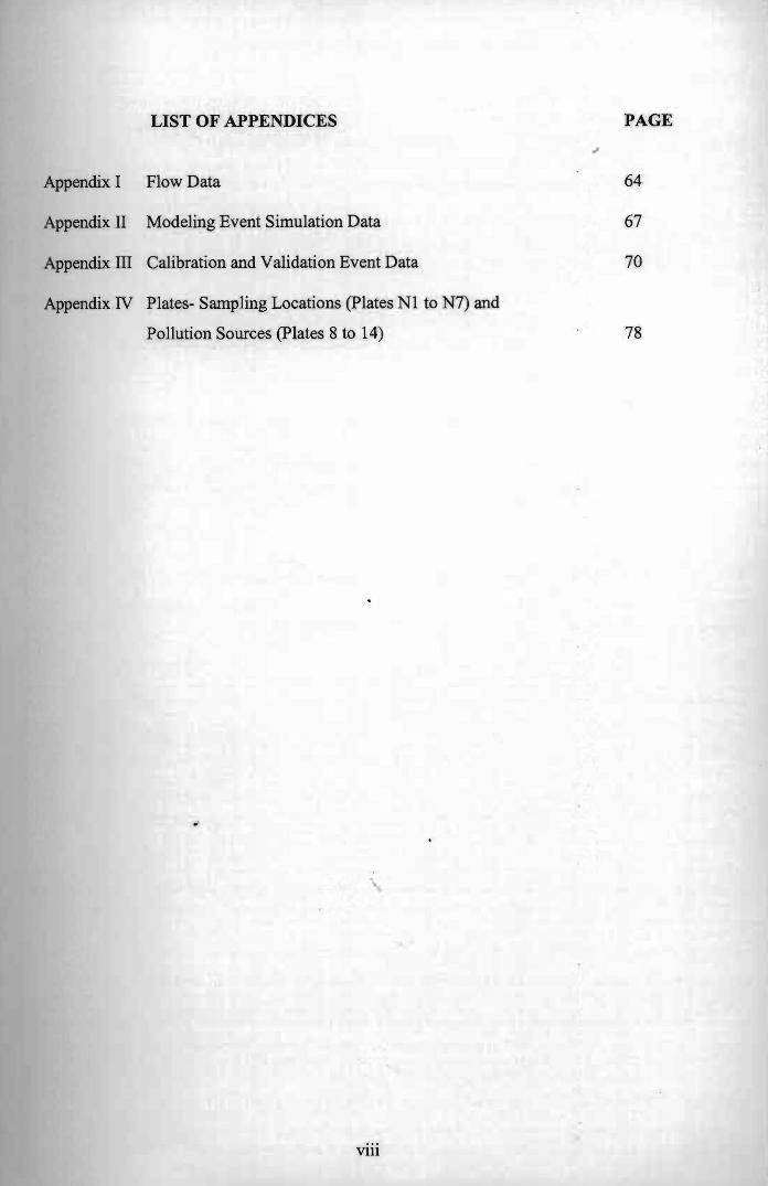
LIST OF APPENDICES PAGE
",
64Appendix I Flow Data
67Appendix II Modeling Event Simulation Data
70Appendix III Calibration and Validation Event Data
Appendix IV Plates- Sampling Locations (Plates N1 to N7) and
Pollution Sources (plates 8 to 14) 78
.'
Vlll
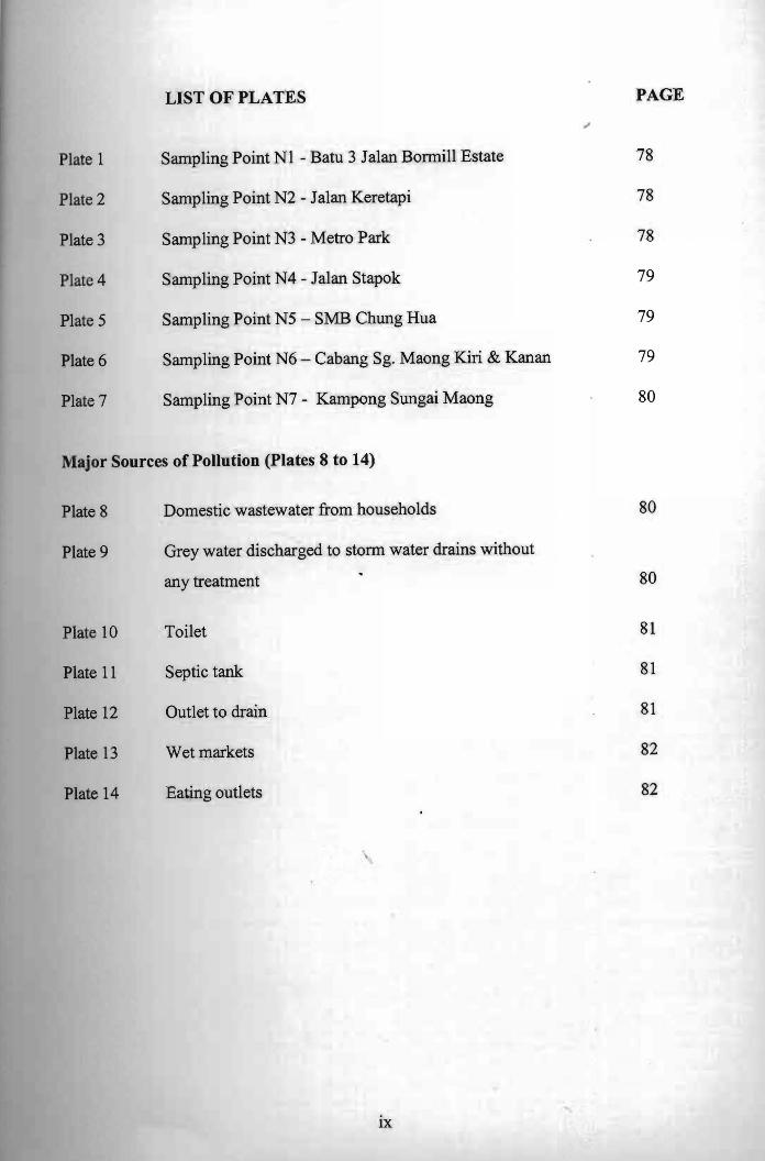
PAGELIST OF PLATES
78Plate 1 Sampling Point NI - Batu 3 Jalan Bonnill Estate
78Plate 2 Sampling Point N2 - J alan Keretapi
78Plate 3 Sampling Point N3 - Metro Park
Plate 4 Sampling Point N4 - Jalan Stapok 79
Plate 5 Sampling Point N5 - 5MB Chung Hua 79
Plate 6 Sampling Point N6 - Cabang Sg. Maong Kiri & Kanan 79
Plate 7 Sampling Point N7 - Kampong Sungai Maong 80
Major Sources of Pollution (plates 8 to 14)
Plate 8 Domestic wastewater from households 80
Plate 9 Grey water discharged to stonn water drains without
any treatment 80
81Plate 10 Toilet
Plate 11 Septic tank 81
Plate 12 Outlet to drain 81
Plate 13 Wet markets 82
Plate 14 Eating outlets 82
IX
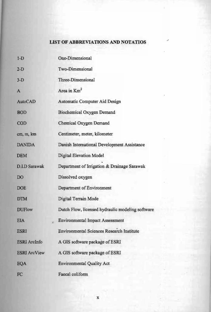
I-D
2-D
3-D
A
AutoCAD
BOD
COD
cm, m, Ian
DANIDA
DEM
D.I.D Sarawak
DO
DOE
D1M
DUFlow
EIA
ESRI
ESRI ArcInfo
ESRI ArcView
EQA
FC
LIST OF ABBREVIATIONS AND NOTATIOS
One-Dimensional
Two-Dimensional
Three-Dimensional
Area in Km2
Automatic Computer Aid Design
Biochemical Oxygen Demand
Chemical Oxygen Demand
Centimeter, meter, kilometer
Danish International Development Assistance
Digital Elevation Model
Department of Irrigation & Drainage Sarawak
Dissolved oxygen
Department of Environment
Digital Terrain Mode
Dutch Flow, licensed hydraulic modeling software
• Environmental Impact Assessment
Environmental Sciences Resea~ch Institute
A GIS software package ofESRI
A GIS software package ofESRI
Environmental Quality Act
Faecal coliform
x
GeoPlan
GIS
Hr
InfoWorks
InfoWorKs RS
ISIS
Kpg.
L
Maplnfo
mg/1
NREB
NREO
NWQS
n
Q
Qp
RWQMP
Sg.
TSS
TCC
tb
Geographical Plan, a GIS tool of InfoWorks RS
Geographical Infonnation System
Hour
A licensed hydraulic modeling software of Wallingford
Software Ltd. UK
River Simulation, a modeling software package of info Works
A licensed hydraulic modeling software of Wallingford
Software Ltd. UK
Kampong
Length in m
A licensed GIS software
milligram per litre
Natural Resources & Environment Board
Natural Resources and Environment Ordinance
National Water Quality Standards
Manning's roughness Coefficient
Discharge in m3Is
Peak Discharge in m3/s
River Water Quality Monitoring Programme
Sungai
Total suspended solid
Total colifonn count
Time Base
xi

Time of Concentrationtc
Time to Peak tp
Triangulated Irregular Network TIN
University Malaysia Sarawak UNIMAS
Volume in m3 V
Velocity in m3 v
Water Ordinance WO
XlI

ABSTRACT

ABSTRACT
In this study a modeling technique, the InfoWorks RS software with GIS-based
was used to study the water quality of Sungai Maong. A water quality simulation model
for Sungai Maong was explored with a focus on predicting the dissolved oxygen (DO)
parameter. The model adopted a hydrodynamic flow simulation to capture advection
and diffusion due to different flow condition~ The on-site hourly (from 9:00 to 15:00)
DO data from seven sampling locations (3rd Mile, lIn Bormill Estate N1, lambatan lIn
Keretapi N2, lambatan Metro Park N3, lambatan lIn Stapok N4, 5MB Chung Hua N5,
Cabang Sg. Maong Kiri & Kanan N 6 and Kpg. Sg Maong N7) along Sungai Maong
were collected in December 2006. The hourly DO data collected is considered as
Concentration-Time Boundary pollutants. The data was fed into the model except one
station N5 that was selected for validation purposes. The calibration of a decay rate, K
oforganic matters was found to be satisfactory at a rate of 0.1 per day. The correlation
coefficient of the observed and simulated DO concentration at 5MB Chung Hua Station
(N5) was at 0.82 (82%). The low DO readings and the slow decay rate of organic
matters indicated that the river is alarmingly unhealthy. The developed model by the
means values is deliberately descriptive of the transportation of the DO in response to
the decaying components. Hypothetical flow conditions of high and low flow scenarios
in Sungai Maong Kiri were tested against the advection and diffusion of the concerned
pollutants. For demonstration here, an average day in December was simulated at the
urban center of Central Park Station (3 rd Miles Area). The results show that the flow
conditions had little effects on the DO concentration. The river could be said as being
lost ofits ability to self-cleansing.
XIV

ABSTRAK
Dalam kajian ini, perisian Infoworks berasakan GIS telah digunakan untuk
mengkaji kualiti air Sungai Maong. Model simulasi kualiti air Sungai Maong telah
diteliti dengan memfokuskan kepada ramalan parameter oksigen yang terlarut (DO).
Model in; telah menggunakan simulasi aliran hidrodinamik untuk mendapatkan adveksi
dan diffusi disebabkan keadaan pengaliran yang berbeza. Data DO setiap jam telah
dikumpulkan dari tujuh lokasi kajian di sepanjang Sungai Maong (iaitu Batu 3, Jln
Bormill Estate N1, Jambatan Jln Keretapi N2, Jambatan Metro Park N3, Jambatan Jln
Stapok N4, 5MB Chung Hua NS, Cabang Sg. Maong Kiri & Kanan N6 and Kpg. Sg
Maong N7) pada bulan Disember 2006. Data terkumpul itu dianggap sebagai
pencemaran sempadan masa kecekapan. Data tersebut dimasukkan ke dalam model
kecuaJi stesen NS yang telah dipilih untuk tujuan verifikasi kajian. Kalibrasi untuk
kadar reputan, K, bagi bahan organic didapati memuaskan pada kadar 0.1 per hari.
KoejJlsien leolerasi bagi bacaan DO yang dikaji di lapangan dan bacaan simulasi DO
untuk NS adalah 0.82 (82%). Bacaan DO dan kadar pereputan yang rendah
menunjukkan bahawa Sungai Maong mengalami pencemaran yang amat tinggi. Model
yang dibina telah mengambil kira kepekatan DO berkadaran dengan komponen.
Senario pengaliran hipotetikal pada kadar tinggi dan rendah di Sungai Maong Kiri
telah diuji berbanding adveksi dan difJusi bahan pencemaran yang terlibat. Sebagai
(contoh keadaan) hari biasa bulan Disember telah disimulasikan di pusat Bandar
Central Park Station (Kawasan Batu 3). Hasil kajian menunjukkan keadaan pengaliran
IIdDk memberikan kesan yang tinggi terhadap kepekatan DO. Maka Sungai Maong
boleh dikatakan sebagai hilang keupayaan untuk pembersihan semulajadi.
xv
--=

Chapter 1
INTRODUCTION

CHAPTER!
INTRODUCTION
1.1 Background of Sungai Maong
Sungai Maong flows through the south-western parts of Kuching City. It is one
of the tributaries of Sungai Sarawak and the largest sub-catchment draining the city
into Sungai Sarawak. Sungai Maong has two tributaries, the Sungai Maong Kiri and
Sungai Maong Kanan. The Sungai Maong catchment covers an area of about 47 km2
passing through the sub-urban Batu Tiga and Batu Kawa areas. The tributary
confluences with Sungai Sarawak at about 37 km from the river mouth, therefore the
tidal flushing is significant in removing pollutant from the river system naturally, prior
to the construction of Kuching barrage in 1998.
Table 1: Characteristics of Sungai Maong
Name of River Catcbment Areas (kml) Length of River (km)
S1Dlgai Maong Kiri
• at confluence
• at Batu Tiga Bridge
19.94 .
10.55
8.3
S1Dlgai Maong Kanan
• at confluence
• at Batu Kawa Road Bridge
19.05
12.20
7.5
I
Source: Department of Irrigation & Drainage Sarawak
1

Figure 1: Sungai Sarawak System and Kuching City.
Sungai Sarawak had experienced a major flow regime change. In 1998, under
the Sungai Sarawak Regulation Scheme the State Government established the
Kuching Barrage (Figure 1) with gate systems to control the floodwater level
especially in front of the city center. The operation of the gate systems have reduced
the tidal flushing, thereby partly caused the deterioration of water quality. The
situation is caused by the narrow fluctuation range of river water level and the
meandering nature of the river.
As Sungai Maong (Figure 2) runs through the city, its water quality is greatly
affected by the land use and activities of the area. Urbanization has been linked to the
2

degradation of the urban waterways which has adverse impact on the quantity, quality
and distribution of the Sarawak's water resources (Memon and Murtedza, 1999).
There are more than 70,000 of Kuching population residing in the catchment, mostly
along Sungai Maong Kiri. The public generally perceives Sungai Maong as a waste
dumping conduit.
The Sarawak State Government is concerned with the health hazard potential
in the area. In view of the urgency to minimize and control the water quality
degradation, the Sarawak State Government and all the relevant agencies are
responsible to carry out their respective functions. As the lead environmental agency
in the State, pursuant to Section 5 of the Natural Resources and Environment
Ordinance, Chap. 84 (Laws of Sarawak), 1993, the Natural Resources and
Environment Board (NREB) embarked on the River Water Quality Monitoring
Program (RWQMP) in 1999. This programme will continue into the future, with the
objective of establishing a baseline data for the relevant agencies that are involved in
river management in the State.
As the State g~vernment aims to meet its target of Class lIB water quality in
most of its rivers, it is a tremendous task ahead to identify measures and develop
strategies to fulfill this ambition. It demands a huge amount of resources to undertake
such ambition and achieve its goals. The constraint of such resources demands that
llrategies be formulated to identify rivers that can be rehabilitated with stringent goals
to achieve Class lID quality.
3

Figure 2: Study Area - Catchment map of Sungai Maong
Source: Department of Irrigation & Drainage Sarawak
4

Kh'dmat Maklumat Akademik Pusat 1 ..... A 1 AYSlA SARAWAJ(UNlVERSm lT~
1.2 Water Quality Issues of Sungai Maong
Sungai Maong is affected by many problems, including flash flooding and poor
water quality and poor river aesthetic and often perceived by the general public as a
waste dumping conduit. It is heavily polluted by high concentrations of organic
matters, Biochemical Oxygen Demand (BOD) levels and ammoniacal nitrogen. In
addition, the river is highly polluted with faecal-derived coliform bacteria (NREB,
2002).
Based on the study conducted by Danish International Development Agency
(DANIDA) in corporation with NREB Sarawak through Sustainable Urban
Development Project (NREB, 2001), reported that households are by far the main
lQU1'Ces of pollution, followed by food outlets in the Sungai Maong catchment area.
Most residential households in Kuching city are equipped with two separate
WlllDwater outlets systems, one outlet for black water (toilet water) and a number of
UUI.m&ZIi for grey water (washing, bathing, kitchen and cleaning). Grey water from
JIG_balds is discharged directly to the storm water drains without any treatment.
water is treated in individual tanks at each premise, though few housing estates
covered by co~munal treatment facilities (Iml}.off tanks). Overflows from the
• tanks are directed to the storm water drains as well.
Few food outlets are installed with oil and grease trap. Most of the food outlets
c1iIcbarging wastewater directly into the storm water drains. Oil and grease clogs
- 1III.anmlS and is a cause for foul odour.
5

1.3 Sungai Maong Water Quality Status
In line with the main objective of RWQMP, water samples are collected at four
fixed locations and monitored monthly along the Sungai Maong Kiri, most densely
populated area (Figure 3). The degree of pollution in Sungai Maong is monitored and
recorded by NREB since the year 1999. Water samples were collected and analysed
for biochemical oxygen demand (BODs), chemical oxygen demand (COD), total
auspended solid (TSS), ammoniacal nitrogen, total colifonns counts (TCC) and faecal
colifonns (FC). pH, dissolved oxygen (DO), conductivity, turbidity, salinity and
temperature are measured in-situ using portable equipments .
. The average concentration of different monitoring parameter is statistically
l88eased in the attempt to make evaluation and classification of the river system by
compared to the (National Water Quality Standards for Malaysia (NWQSM) and Class
of the standards which has been set as a goal for all rivers in Sarawak. The
contamination of faecal bacteria is still identified as the major problem in Sungai
'."10 Faecal bacteria pollution encountered in Sungai Maong is mainly attributed to . ow septic tanks, raw sewage and wet markets. The other pollutants that
,_.rately degraded the Sungai Maong water quality are identified as nutrients and
6