Embed Size (px)
Citation preview

MICHIGANMICHIGANSOURCE WATER ASSESSMENT SOURCE WATER ASSESSMENT
PROGRAMPROGRAMMichigan Section AWWA Annual ConferenceMichigan Section AWWA Annual Conference
September 15, 2000September 15, 2000
Bradley B. Brogren, P.E.Bradley B. Brogren, P.E.
Michigan Department of Environmental QualityMichigan Department of Environmental Quality
Michael J. Sweat, P.G.Michael J. Sweat, P.G.
U.S. Geological SurveyU.S. Geological Survey

1996 Amendments to the Federal1996 Amendments to the FederalSAFE DRINKING WATER ACTSAFE DRINKING WATER ACT
Require States to:Require States to:
• Identify the areas that supply public Identify the areas that supply public drinking water.drinking water.
• Inventory contaminants and assess water Inventory contaminants and assess water susceptibility to contamination.susceptibility to contamination.
• Inform the public of the results.Inform the public of the results.

STATE SOURCE WATER ASSESSMENT PROGRAM STATE SOURCE WATER ASSESSMENT PROGRAM SCHEDULESCHEDULE
Final Guidance Published by US-EPA August 6, Final Guidance Published by US-EPA August 6, 19971997
- Requires Submittal of State SWAP by February - Requires Submittal of State SWAP by February 19991999
Michigan Submitted to USEPA on February 1, 1999Michigan Submitted to USEPA on February 1, 1999
- USEPA Approval of Programs by November 1999- USEPA Approval of Programs by November 1999 USEPA Approved on October 22, 1999USEPA Approved on October 22, 1999
- Allowable Extension to Complete by May 2003- Allowable Extension to Complete by May 2003 Extension Granted by USEPAExtension Granted by USEPA

MICHIGAN PUBLIC WATER SUPPLIES MICHIGAN PUBLIC WATER SUPPLIES REQUIRING ASSESSMENTSREQUIRING ASSESSMENTS
Noncommunity, Groundwater SuppliesNoncommunity, Groundwater Supplies
Nontransient =Nontransient = 17201720 Transient = Transient = 8930 8930
Community, Groundwater Supplies =Community, Groundwater Supplies = 12501250
Community, Surface Water Supplies = Community, Surface Water Supplies = 70
Total = 11970
Estimated Number of Sources to Assess is 18,000

MICHIGANMICHIGANSOURCE WATER ASSESSMENT PROGRAMSOURCE WATER ASSESSMENT PROGRAM
Funded through Drinking Water Revolving FundFunded through Drinking Water Revolving Fund Formed SWAP Advisory Committees to ImplementFormed SWAP Advisory Committees to Implement
Technical Advisory SubcommitteeTechnical Advisory SubcommitteePublic Advisory Subcommittee Public Advisory Subcommittee
Utilize VulnerabilityUtilize Vulnerability Assessments, Sanitary Surveys,Assessments, Sanitary Surveys, Existing Monitoring DataExisting Monitoring Data Incorporate Wellhead Protection ProgramIncorporate Wellhead Protection Program Include State Pesticide Management PlanInclude State Pesticide Management Plan Use Watershed Initiative AssessmentsUse Watershed Initiative Assessments Reference Clean Water Act AssessmentsReference Clean Water Act Assessments
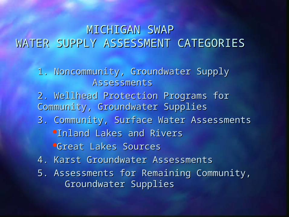
MICHIGAN SWAPMICHIGAN SWAPWATER SUPPLY ASSESSMENT WATER SUPPLY ASSESSMENT
CATEGORIESCATEGORIES
1. Noncommunity, Groundwater Supply 1. Noncommunity, Groundwater Supply AssessmentsAssessments
2. Wellhead Protection Programs for 2. Wellhead Protection Programs for Community, Groundwater SuppliesCommunity, Groundwater Supplies
3. Community, Surface Water Assessments3. Community, Surface Water AssessmentsInland Lakes and RiversInland Lakes and RiversGreat Lakes SourcesGreat Lakes Sources
4. Karst Groundwater Assessments4. Karst Groundwater Assessments 5. Assessments for Remaining Community, 5. Assessments for Remaining Community,
Groundwater Supplies Groundwater Supplies

WELLHEAD PROTECTION PROGRAMSWELLHEAD PROTECTION PROGRAMSFOR COMMUNITY, GROUNDWATER SUPPLIESFOR COMMUNITY, GROUNDWATER SUPPLIES
1986 amendments to Federal Safe Drinking Water 1986 amendments to Federal Safe Drinking Water Act established WHP programs.Act established WHP programs.– MDEQ program approved by USEPA.MDEQ program approved by USEPA.
A MDEQ approved local WHP Program is a Source A MDEQ approved local WHP Program is a Source Water Assessment with Susceptibility Determination. Water Assessment with Susceptibility Determination.
Current WHP Activities include:Current WHP Activities include:– Low Tritium Designated CommunitiesLow Tritium Designated Communities– Delineated WellheadsDelineated Wellheads– Approved Local Programs Approved Local Programs
WHP Grant Program:WHP Grant Program:– State $$ Match local WHP expenditures.State $$ Match local WHP expenditures.
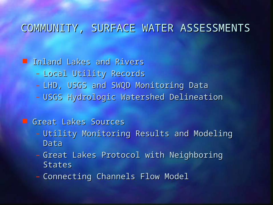
COMMUNITY, SURFACE WATER ASSESSMENTSCOMMUNITY, SURFACE WATER ASSESSMENTS
Inland Lakes and RiversInland Lakes and Rivers– Local Utility RecordsLocal Utility Records– LHD, USGS and SWQD Monitoring DataLHD, USGS and SWQD Monitoring Data– USGS Hydrologic Watershed Delineation USGS Hydrologic Watershed Delineation
Great Lakes SourcesGreat Lakes Sources– Utility Monitoring Results and Modeling DataUtility Monitoring Results and Modeling Data– Great Lakes Protocol with Neighboring Great Lakes Protocol with Neighboring
StatesStates– Connecting Channels Flow ModelConnecting Channels Flow Model
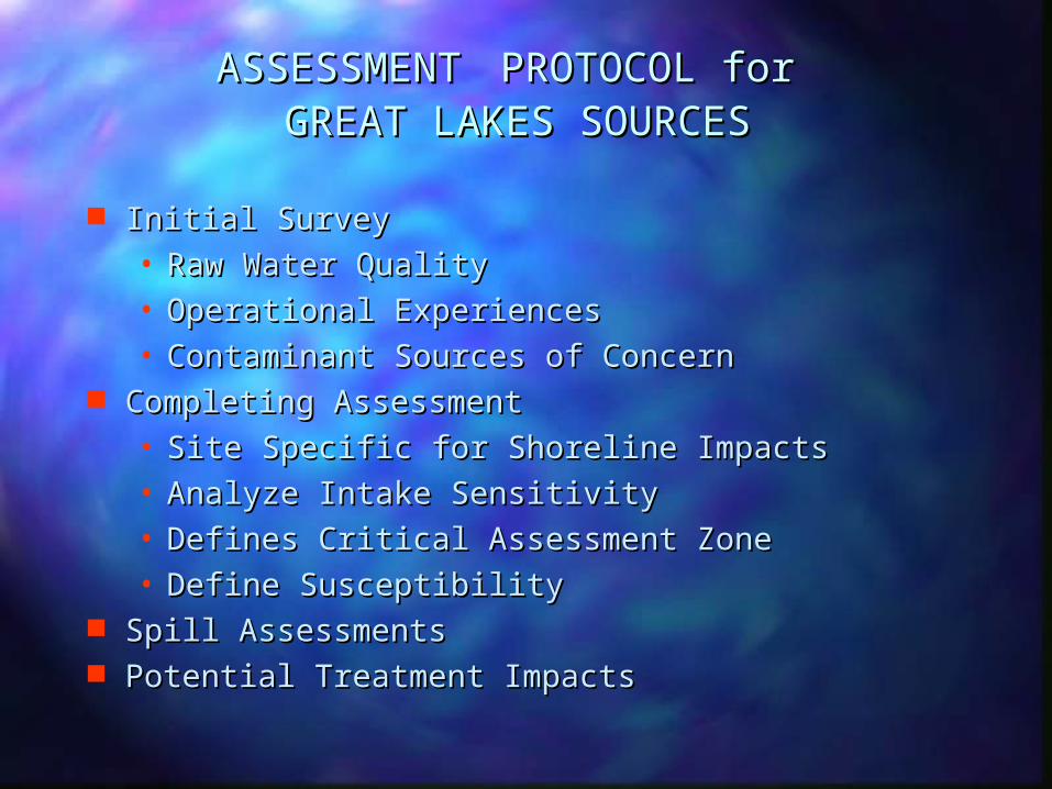
ASSESSMENTASSESSMENT PROTOCOL for PROTOCOL for GREAT LAKES SOURCESGREAT LAKES SOURCES
Initial SurveyInitial Survey• Raw Water QualityRaw Water Quality• Operational ExperiencesOperational Experiences• Contaminant Sources of ConcernContaminant Sources of Concern
Completing AssessmentCompleting Assessment• Site Specific for Shoreline ImpactsSite Specific for Shoreline Impacts• Analyze Intake SensitivityAnalyze Intake Sensitivity• Defines Critical Assessment ZoneDefines Critical Assessment Zone• Define SusceptibilityDefine Susceptibility
Spill AssessmentsSpill Assessments Potential Treatment ImpactsPotential Treatment Impacts

KARST GROUNDWATER ASSESSMENTSKARST GROUNDWATER ASSESSMENTS
Aquifers subject to surface or near surface Aquifers subject to surface or near surface contaminationcontamination– Identify Karst AreasIdentify Karst Areas– Inventory Noncommunity and Community Inventory Noncommunity and Community
Water Supply WellsWater Supply Wells– Conventional Groundwater Modeling Not Conventional Groundwater Modeling Not
ApplicableApplicable– USGS to Assist with AssessmentsUSGS to Assist with Assessments
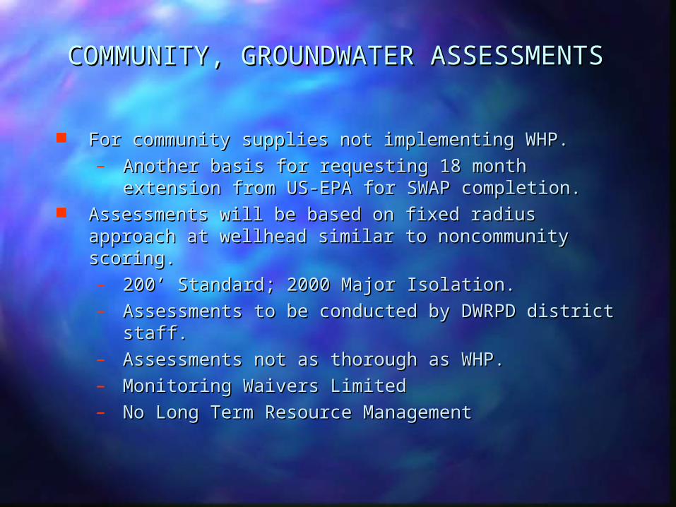
COMMUNITY, GROUNDWATER ASSESSMENTSCOMMUNITY, GROUNDWATER ASSESSMENTS
For community supplies not implementing WHP.For community supplies not implementing WHP.– Another basis for requesting 18 month extension Another basis for requesting 18 month extension
from US-EPA for SWAP completion.from US-EPA for SWAP completion. Assessments will be based on fixed radius approach Assessments will be based on fixed radius approach
at wellhead similar to noncommunity scoring. at wellhead similar to noncommunity scoring. – 200’ Standard; 2000 Major Isolation.200’ Standard; 2000 Major Isolation.– Assessments to be conducted by DWRPD district Assessments to be conducted by DWRPD district
staff.staff.– Assessments not as thorough as WHP.Assessments not as thorough as WHP.– Monitoring Waivers LimitedMonitoring Waivers Limited– No Long Term Resource ManagementNo Long Term Resource Management

SOURCE WATER ASSESSMENTS INCLUDE:SOURCE WATER ASSESSMENTS INCLUDE:
DelineationDelineation Contaminant Source InventoryContaminant Source Inventory Abandon Well Survey MethodologiesAbandon Well Survey Methodologies Sensitivity AnalysisSensitivity Analysis Susceptibility DeterminationSusceptibility Determination

DELINEATION OF SOURCE WATER DELINEATION OF SOURCE WATER PROTECTION AREASPROTECTION AREAS
For Ground WaterFor Ground Water-Determined by Modeling Ten Year Time of -Determined by Modeling Ten Year Time of
Travel for WHPA Travel for WHPA-Defined by Fixed Radius Approach for -Defined by Fixed Radius Approach for
Noncommunity/Community Water Supplies Noncommunity/Community Water Supplies
For Surface Water For Surface Water -Defined -Defined by Watershed Boundariesby Watershed Boundaries
-Defined by Flow Model-Defined by Flow Model -Includes Critical Assessment Zone-Includes Critical Assessment Zone

ST. CLAIR RIVER - LAKE ST. CLAIR - DETROIT ST. CLAIR RIVER - LAKE ST. CLAIR - DETROIT RIVER FLOW MODELRIVER FLOW MODEL
Partnership - MDEQ, USGS, DWSD, USACE, NOAAPartnership - MDEQ, USGS, DWSD, USACE, NOAA
Phase I - Hydrodynamic ModelPhase I - Hydrodynamic Model– Define Grid Geometry, BathymetryDefine Grid Geometry, Bathymetry
Phase II - Water Quality MonitoringPhase II - Water Quality Monitoring– Input Contaminant SourcesInput Contaminant Sources– Hydraulic LoadingsHydraulic Loadings
Phase III - Particle Tracking Phase III - Particle Tracking – Spill Analyses, Contingency PlanningSpill Analyses, Contingency Planning

CONTAMINANT SOURCE INVENTORYCONTAMINANT SOURCE INVENTORY
Identify and Inventory Contaminant SourcesIdentify and Inventory Contaminant Sources
Describe Contaminant Sources within Source Describe Contaminant Sources within Source Water Protection AreaWater Protection Area
Target Sources for Further InvestigationTarget Sources for Further Investigation
Collect and Interpret New InformationCollect and Interpret New Information
Verify Accuracy and Reliability of InformationVerify Accuracy and Reliability of Information

SENSITIVITY ANALYSISSENSITIVITY ANALYSIS
Relative ease at which a contaminant can Relative ease at which a contaminant can migrate to water supply source.migrate to water supply source.
Measures inability of natural materials or Measures inability of natural materials or hydrology conditions to protect source.hydrology conditions to protect source.
A function of intrinsic characteristics of the A function of intrinsic characteristics of the geologic materials that compose the land geologic materials that compose the land surface, and the saturated and unsaturated surface, and the saturated and unsaturated zones.zones.
Independent of land use or contaminant Independent of land use or contaminant characteristics.characteristics.
Considers Well or Intake ConstructionConsiders Well or Intake Construction

SUSCEPTIBILITY DETERMINATIONSUSCEPTIBILITY DETERMINATION
Required by USEPA for all Public Water Supply Required by USEPA for all Public Water Supply Sources Sources
Determined using sensitivity analysis, source Determined using sensitivity analysis, source water protection area and contaminant water protection area and contaminant inventory.inventory.
Describes potential for a contaminant to impact Describes potential for a contaminant to impact a source of drinking water.a source of drinking water.
Evaluates if contaminant could reach source at Evaluates if contaminant could reach source at concentrations that could affect system’s ability concentrations that could affect system’s ability to meet all regulatory requirements.to meet all regulatory requirements.
Also includes consideration of abandoned wells.Also includes consideration of abandoned wells.

RESULTS OF SOURCE WATER ASSESSMENTSRESULTS OF SOURCE WATER ASSESSMENTS
Used by DWRPD and LHD’s to determine Used by DWRPD and LHD’s to determine future monitoring waivers.future monitoring waivers.
To Inform PublicTo Inform Public
To Initiate Source Water Protection Activities To Initiate Source Water Protection Activities
Develop Contingency PlanningDevelop Contingency Planning

INFORMING THE PUBLICINFORMING THE PUBLIC
Reports Readily Available and UnderstandableReports Readily Available and Understandable– From Local Utility/Water SupplierFrom Local Utility/Water Supplier
Utilities required to notify customers of Utilities required to notify customers of availability in Consumer Confidence availability in Consumer Confidence Reports.Reports.
– From MDEQ/LHD’sFrom MDEQ/LHD’s
Use of the InternetUse of the Internet– MDEQ currently has SWAP and wellhead MDEQ currently has SWAP and wellhead
delineations/community status on delineations/community status on department web site (www.deq.mi.us/dwr/).department web site (www.deq.mi.us/dwr/).
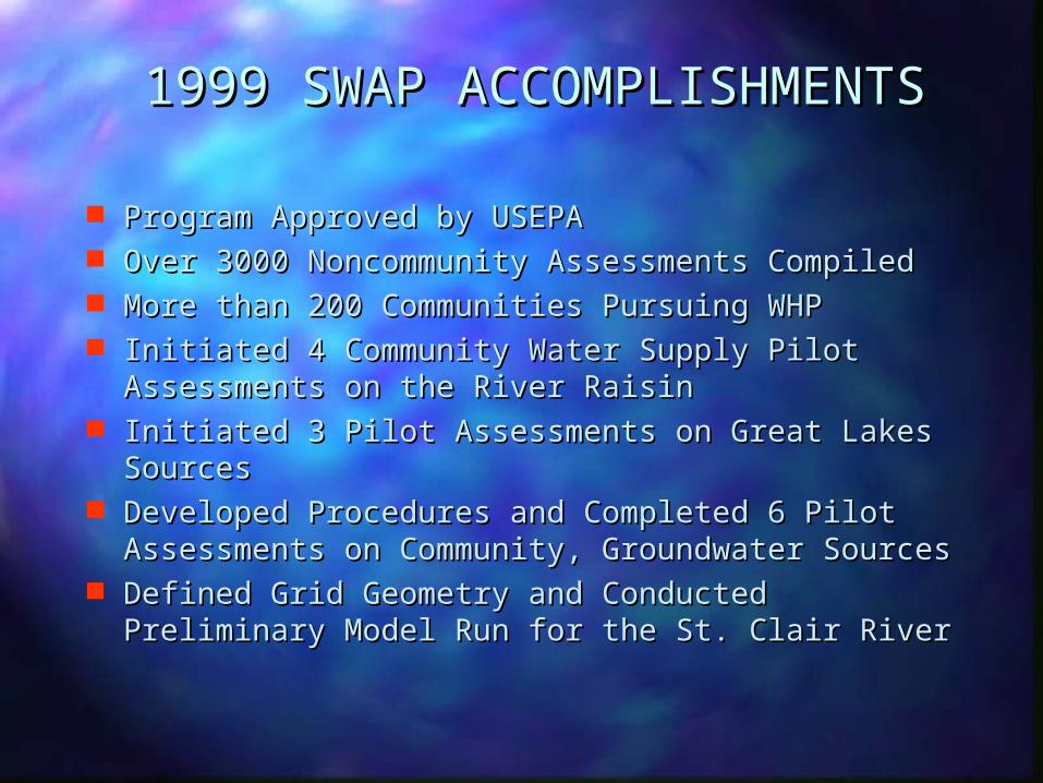
1999 SWAP ACCOMPLISHMENTS1999 SWAP ACCOMPLISHMENTS
Program Approved by USEPAProgram Approved by USEPA Over 3000 Noncommunity Assessments CompiledOver 3000 Noncommunity Assessments Compiled More than 200 Communities Pursuing WHPMore than 200 Communities Pursuing WHP Initiated 4 Community Water Supply Pilot Initiated 4 Community Water Supply Pilot
Assessments on the River RaisinAssessments on the River Raisin Initiated 3 Pilot Assessments on Great Lakes Initiated 3 Pilot Assessments on Great Lakes
SourcesSources Developed Procedures and Completed 6 Pilot Developed Procedures and Completed 6 Pilot
Assessments on Community, Groundwater SourcesAssessments on Community, Groundwater Sources Defined Grid Geometry and Conducted Preliminary Defined Grid Geometry and Conducted Preliminary
Model Run for the St. Clair RiverModel Run for the St. Clair River

2000 SWAP WORKPLAN2000 SWAP WORKPLAN Initiate 3000 More Noncommunity AssessmentsInitiate 3000 More Noncommunity Assessments Pursue Additional WHP Program Approvals Pursue Additional WHP Program Approvals Complete Preliminary River Raisin AssessmentsComplete Preliminary River Raisin Assessments Complete Preliminary Great Lakes AssessmentsComplete Preliminary Great Lakes Assessments Complete St. Clair - Detroit Rivers Connecting Complete St. Clair - Detroit Rivers Connecting
Channel Hydraulic Flow ModelChannel Hydraulic Flow Model Complete Karst Mapping and Inventory SourcesComplete Karst Mapping and Inventory Sources Finalize Community Groundwater Assessment Finalize Community Groundwater Assessment
Procedure and Initiate Assessments with FOS Procedure and Initiate Assessments with FOS StaffStaff
Initiate County Vulnerability Mapping Effort Initiate County Vulnerability Mapping Effort through through
MSU-IWR, GEM Centers and LHD’sMSU-IWR, GEM Centers and LHD’s Meet with SWAP Committees, LHD’s, MSU, GEM Meet with SWAP Committees, LHD’s, MSU, GEM
Centers and Communities involved in SWAPCenters and Communities involved in SWAP
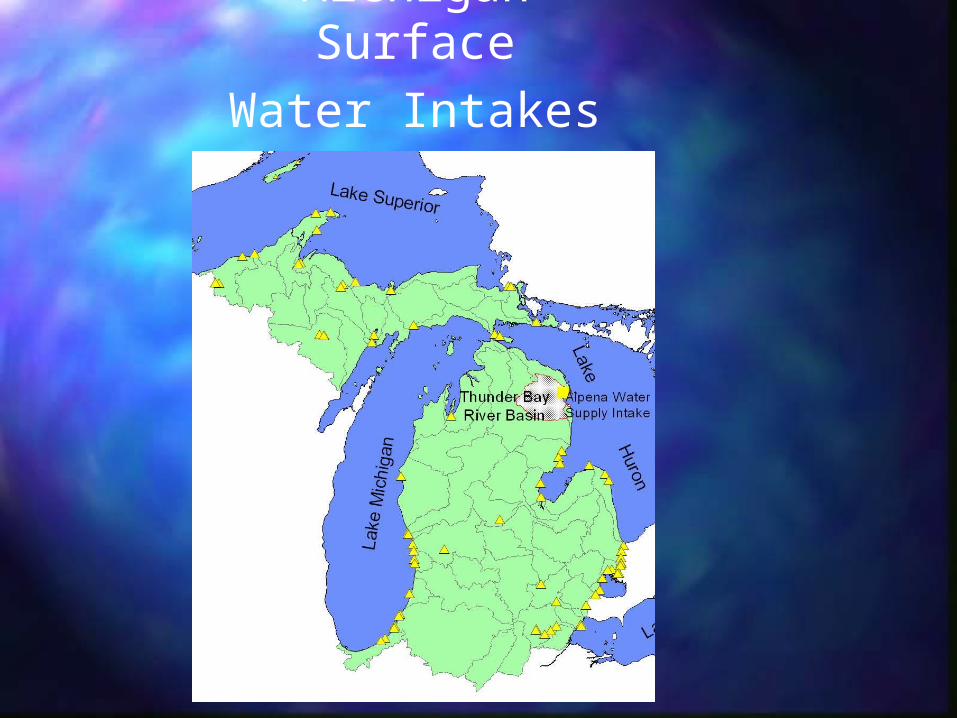
Michigan Surface
Water Intakes

SENSITIVITYSENSITIVITY-- DETERMINED FROM THE NATURAL -- DETERMINED FROM THE NATURAL SETTING OF THE SOURCE WATER AND THE SETTING OF THE SOURCE WATER AND THE CONSTRUCTION AND LOCATION OF THE CONSTRUCTION AND LOCATION OF THE INTAKEINTAKE
SUSCEPTIBILITYSUSCEPTIBILITY-- IDENTIFIES FACTORS THAT MAY POSE A -- IDENTIFIES FACTORS THAT MAY POSE A RISK WITHIN THE COMMUNITY’S SOURCE RISK WITHIN THE COMMUNITY’S SOURCE WATER AREAWATER AREA-- PROVIDES INFORMATION WITH RESPECT -- PROVIDES INFORMATION WITH RESPECT TO LISTED FACILITIES AND/OR LAND USES TO LISTED FACILITIES AND/OR LAND USES WITHIN THE SOURCE WATER AREA THAT WITHIN THE SOURCE WATER AREA THAT SHOULD BE GIVEN GREATER PRIORITY SHOULD BE GIVEN GREATER PRIORITY AND OVERSIGHT IN IMPLEMENTING A AND OVERSIGHT IN IMPLEMENTING A SOURCE WATER PROTECTION PROGRAMSOURCE WATER PROTECTION PROGRAM

SENSITIVITY ANALYSIS AND SUSCEPTIBILITY DETERMINATION
INLAND CONNECTING CHANNELS AND RIVERS GREAT LAKES SOURCES
SENSITIVITY VERY HIGH HIGH MODERATE
CONTAMINANTINVENTORY
SUSCEPTIBILITYDETERMINATION
LISTED NON-LISTED LISTED NON-LISTEDLISTED NON-LISTED
VERYHIGH HIGH HIGH
MOD.HIGH
MOD.HIGH MOD.

CriticalCritical
SensitivitySensitivity Assessment Assessment
Value Value Zone Zone
Sensitivity Value Sensitivity Value
is determinedis determined <25,000<25,000 3,000 foot radius3,000 foot radius
by the length of by the length of
the intake timesthe intake times 25,000-125,00025,000-125,000 2,000 foot radius2,000 foot radius
the depth of thethe depth of the
intake intake >125,000>125,000 1,000 foot radius1,000 foot radius


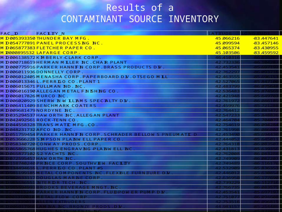
ID MAD_ID LOC_REF_ID FAC_ID FACILITY_N LATITUDE LONGITUDE BND_FLAGNPL_STAT_I49707THNDR666MC 4 634813 MID005393350 THUNDER BAY MFG. 45.066216 -83.44764149707PNLPR120NI 4 634811 MID054777891 PANEL PROCESSING INC. 45.099594 -83.45714649707FLTCH318WF 4 634808 MID065877383 FLETCHER PAPER CO. 45.065374 -83.43095549707LFRGCM32PA 12 634810 MI0000895532 LAFARGE CORP. 45.103506 -83.45959249862KMBRL601EM 4 634851 MID006138572 KIMBERLY-CLARK CORP. 46.410316 -86.63620749423HRMNM1400S 15 634530 MID000718619 HERMAN MILLER INC. CHAIR PLANT 42.732336 -86.10428749078PRKRH300PA 15 634314 MID000775916 PARKER HANNIFIN CORP. BRASS PRODUCTS DIV. 42.453541 -85.69719749423DNNLL414E4 4 634522 MID006011936 DONNELLY CORP. 42.762297 -86.09371649078MNSHC320NF 4 634312 MID006012405 MENASHA CORP. PAPERBOARD DIV. OTSEGO MILL 42.463555 -85.69615349010LPRRG117WA 4 634230 MID006013346 L. PERRIGO CO. PLANT 1 42.527065 -85.84710049010PLLMN55761 4 634232 MID006015671 PULLMAN IND. INC. 42.483799 -86.07564849010LLGNM1274L 4 634229 MID006016190 ALLEGAN METAL FINISHING CO. 42.536483 -85.87456949080MRCNC11ELE 4 634320 MID006017826 MURCO INC. 42.421948 -85.64970349423GRDSM636E4 4 634528 MID006020929 SHERWIN-WILLIAMS SPECIALTY DIV. 42.761972 -86.08618949078BRKRN602LI 4 634310 MID006411409 BENCHMARK COATERS 42.459976 -85.72128849423NRDYN900BR 4 634537 MID009681479 NORDYNE INC. 42.764412 -86.08347249010HWRTH640RI 4 634228 MID035294537 HAWORTH INC. ALLEGAN PLANT 42.547233 -85.84882649078MDPPR431HE 4 634311 MID042492561 ROCK-TENN CO. 42.464704 -85.70407749423TRNSM300EA 4 634543 MID044558328 TRANS-MATIC MFG. CO. 42.754619 -86.09428449423FCNDS615EA 4 634524 MID048231732 AFCO IND. INC. 42.761998 -86.08680249078SCHRD601SW 4 634315 MID051759454 PARKER HANNIFIN CORP. SCHRADER BELLOWS PNEUMATIC D 42.453490 -85.69443049080SMPSN200AL 4 634322 MID053666228 SIMPSON PLAINWELL PAPER CO. 42.444052 -85.64501149423CNWYP905BR 4 634521 MID058340720 CONWAY PRODS. CORP. 42.764318 -86.08350749080HGHSN15610 4 634319 MID065865768 HUGHES ENGRAVING-PLAINWELL INC. 42.431813 -85.63935649423SYCHT725EA 4 634542 MID065877102 S2 YACHTS INC. 42.762008 -86.08328849423HWRTHONEHA 1 634532 MID072595457 HAWORTH INC. 42.749909 -86.08220749423PRNCC1600S 4 634539 MID118740240 PRINCE CORP. SOUTHVIEW FACILITY 42.749489 -86.11617649010LPRRG538EA 4 634231 MID134494616 L. PERRIGO CO. PLANT #5 42.532909 -85.83635349080MTLCM323AC 4 634321 MID981199185 METAL COMPONENTS INC. FLEXIBLE FURNITURE DIV. 42.446012 -85.63085449406DGLSM6780E 12 634493 MID982633117 DOUGLAS MARINE CORP. 42.636950 -86.17769049423NTRRT1776A 4 634538 MID985586551 INTERIOR TECH. INC. 42.739229 -86.11271649423BRKSB777BR 4 634518 MID985594993 BROOKS BEVERAGE MNGT. INC. 42.766735 -86.08357549078PRKRH100PA 15 634313 MIT270013246 PARKER HANNIFIN CORP. FLUIDPOWER PUMP DIV. 42.453541 -85.69719749423MTLFL259HE 4 634535 MI0001310010 METAL FLOW CORP. 42.751077 -86.09460849423LLNXT1305L 5 634533 MI0001339019 ALLEN EXTRUDERS 42.753516 -86.09681949615LMNNC1000F 12 634782 MID006017966 LAMINA INC. BRONZE PRODS. DIV. 44.983157 -85.25448649622TXSNSHIGHW 12 634783 MID053668018 TEXAS INSTRUMENTS INC. 45.079763 -85.27383648658MGLNN1205W 4 634051 MID005392170 MAGLINE INC. STANDISH PLANT 43.982941 -83.97502148658LMNTD1015W 4 634050 MID985587096 LAMINATED PRODS. INC. 43.982903 -83.97228649946CLTXC200SO 4 634861 MID006129332 CELOTEX CORP. 46.756497 -88.45599749058HSTNGPOBOX 4 634294 MID006019582 HASTINGS FIBER GLASS PRODS. INC. 42.615891 -85.30616649058FLXFB1843G 4 634293 MID006019988 FLEXFAB HORIZONS INTL. FLEXFAB DIV. 42.645679 -85.34500949058HSTNG325NO 4 634296 MID006025324 HASTINGS MFG. CO. 42.650789 -85.28328249058HSTNG1220W 4 634295 MID006545537 VIATEC INC. 42.648766 -85.30452749333BRDFR200LA 4 634478 MID043687391 BRADFORD-WHITE CORP. 42.718000 -85.463140
Results of aCONTAMINANT SOURCE INVENTORY

$T
$T
$T$T
$T
$T
$T$T$T$T$T$T
$T
$T
$T$T$T$T
$T
$T
$T$T
$T
$T
$T
$T
$T
$T$T
$T
$T
$T
$T
$T
$T
$T
$T
$T
$T$T
$T
$T
$T$T
$T
$T
$T$T$T
$T$T
$T
$T
$T
$T
$T
$T
$T
$T
$T
$T
$T
$T
$T
$T$T
$T$T
$T
$T
$T
$T
$T
$T
$T
$T
$T
$T
$T
$T$T
$T
$T
$T
$T
$T
$T
$T
$T
$T
$T
$T
$T$T$T
ÊÚ