Embed Size (px)
Citation preview

MEETING NOTES
Meeting Date: 13 September, 2016 HNTB Project No.: 58404 Project Name: North Florida Master Plan Purpose: Stakeholder Meeting Attendees:
Gregory Krueger (HNTB) Terrel Shaw (HNTB) Sandra Lenis (HNTB) Jennifer Kennedy (HNTB) Dani Booms (HNTB) Jeff Sheffield (North Florida TPO) Alan Mosley (VP of Transportation, Energy and Logistics) Ben Walker (HNTB) Bill Mann (Jacksonville Beach Planning Dept.) Billy Estep (Nassau County EOC) Brad Thoburn (JTA) Brian Cronin (Director of the Office of Operations, FHWA) Bryan Koon (Florida Division of Emergency Management) Carlton Copeland (Jacksonville Public Works Dept.) Carrie Stanbridge (FDOT Construction) Carrol Franklin (Nassau County Ocean Hwy & Port Authority) Chuck White (Jaxport) Dale Allen (Jacksonville Sheriff’s Office ) David Kaufman (JAXPORT) David Shoar (St. Johns County Sheriff's Office) Donald Jacobovitz (Putnam County Public Works Director) Dylan Bryan (FHP) Frank Corrado (Florida Division Office Operations) Greg Evans (FDOT D2 Secretary) Hamid Tabassign (JTA) James Bujeda (JSO Emergency Planning) Jeff Beck (Clay County Engineering Dept.) Jeff Webb (JTA) Jerry Ausher (FDOT Traffic Operations) Jim Boxold (FDOT Central Office Secretary) Jim Knight (FDOT D2) Justin Ryan (FDOT)
Kate Hartman (Columbus Smart City program USDOT) Kathy Seabrook (Jaxport) Kathy Thomas (FDOT Production) Keith Gaston (FHP) Kimberly Hair (Jacksonville Airport Authority) Kurtis Wilson (Director/Fire Chief City of Jacksonville) Larry Parks (FDOT Production) Laurie Santana (MetroLab Grant PM) Lilly Elefteriadou (UF MetroLab) Linda Stoughton (St. John’s Emergency Management) Martha Graham (St. Augustine Planning Dept.) Michael Young (Jacksonville IT Department) Mike Williams (Jacksonville Sheriff's Office) Morrison Braren (Jacksonville Fire/Rescue) Nelson Caparas (Jacksonville Public Works Dept.) Paul Grimes (Leidos (power/electricity)) Peter King (Nassau County Planning Dept.) Peter Windschmidtt (HNTB) Phil Bishop (FDOT Operations) Phong Nguyen (St. Johns County Planning Dept.) Rakesh Sharma (HNTB-FDOT Central Office) Rennee Braddock (Nassau County Sheriff's Office) Rick Beseler (St. Johns County Sheriff's Office) Rodney Cooper (St. Johns County Public Works) Scott Cordero (NOAA National Weather Service Jacksonville) Scott Herring (Nassau County Engineering Dept.) Steve Johnstone (Jaxport) Terry Carr (Jacksonville Environmental Program) Thobias Sando (UNF MetroLab) Vickie Diaz (JSO Communications) William Killingsworth (Planning Director City of Jacksonville)

The following themes were discussed throughout the course of the meeting. Discussion points have been broken out into these categories, and do not necessarily reflect the chronological order in which they were discussed.
Deployment Strategy
Funding
C2Jax Grant Application Process
St. Augustine
Freight/Delivery
Autonomous Vehicles
Emergency Vehicles/Dispatch
Travel Demand Management
Data Management
Drone Technology
Bike/Ped
JTA and other transit
Other Ideas
Deployment Strategy
Find a few key areas to focus on, including rural areas as well as neighborhoods in and around Jacksonville.
Liked how Columbus focused on 4 areas instead of trying to tackle the whole county - need to segment and piece together the highest priority problems
Funding
Need to fit our plan into a more traditional funding effort while also being proactive to apply for other larger grants
Need to be mindful of a much smaller and more drawn out funding scale than what the grant would have provided
Funding for the Smart City winner is $100 million over 4 years, and a portion of that goes to federal grant tracking paperwork
10 years ago, capacity problems dominated the funding pool. Now, hopefully we can get more opportunities to use what we have more efficiently.
The problems being solved are tied to how the funding challenges work o Need stories to help with dollar, time, and life costs - these stories help obtain different
funding o Usage taxes? - this is the dialogue for the future of the highway trust fund
C2Jax Grant Application Process
City had to be the applicant
Collaborative effort - meetings held at TPO
Teamed with TPO, JTA, Chamber of Commerce, and others
Needed to work on a tight timeline
What ideas flushed out? o Reliability-based system o Skyway ramp – not enough time to flesh out before application was due
St. Augustine
Need to update infrastructure for parking and tourism
Moving traffic through the historical area is an issue

Re-routing traffic to major traffic corridors
Needs better event management
A lot congestion happens when the bridge of lions is opened for the boats
Freight/Delivery
Was mentioned that freight is the #1 goal in the area
Jaxport Freight o Greenway implementation important with real time information o They want information from the city about when lights turn green and other
transportation information.
Provide different routes to solve the issue of delivering food on time to this area
Virtual container yards o Located ad street locations (ex. Los Angeles port of Long Beach) o Try to eliminate dead-heading with something like “uber for shipping containers”
Roadside moving and automated trucks
Rail o Rail can shut down the city when something goes wrong o Sometimes, the rail can shut down responders to the hospital
Is there a hospital liaison we can work with? Need to be able to tell the story of why smart cities is important to the region Quantify the costs – lives, hours, $$ lost, etc.
Lift Bridge – would help to have boat sensors and to implement special signal timings to better handle traffic when the bridge goes up
Mapping freight movement - bridge heights, wrong way trucks, etc.
Garbage trucks – tracking them and rearranging schedules depending on the amount of waste produced from residents
Autonomous Vehicles
Can the skyway be used as an autonomous vehicle corridor?
Autonomous mowers for the side of the road?
Autonomous vehicles are cool, but they're still cars. Emergency Vehicles/Dispatch
Need a better way of getting the message out about emergency vehicles coming from behind and incidents ahead
Can we force the message through the radio when an emergency vehicle comes from behind?
Other CV Technology for this?
Need to know about whether or not some bridges can structurally handle large emergency vehicles
Hospitals & Law Enforcement - using real-time traffic information to route the emergency vehicles
Physically move operators into the same building to assist with collaboration
Add cameras to see conditions before arriving
Need real-time traffic information

Connect emergency rooms/doctors to the field – get people in the field to save more lives Travel Demand Management
Google routes people through neighborhoods that aren't the best routes - Waze and Google both tend to route people through notoriously bad roads - in 5-10 years, is this something we can fit? - street use database
System reliability is a challenge - knowing how long it will take to get from A to B - can be variable
HOV/Managed Lanes - something about the center of the corridor being used in the future for transit
Want solutions for TDM tools - congestion pricing, off-peak hours, etc. - demand management, single-occupancy changes, etc.
Data Management
Lane/road closures
Mapping
Road blockage
Weather information
Partnerships to share data
Easy ways to manage and push data
Predictive traffic for the next 5 years
Mobile Eye – finding debris in the road or infrastructure that needs maintenance
Inventory of data in the city
Seems like the need is for a comprehensive data management system which is easy to access and understand - active management data
(Traffic Eng Div. of Jacksonville) - Mapping lane closures and roadway closures in real time - different agencies have closures and don't always collaborate
Is predictive travel data a priority? - seems that they already have a lot of base data - not critical now, but might be critical down the road
Drone Technology
How will this technology affect transportation?
Deliveries – vendors such as Amazon
Traffic monitoring
Inspections
Bike/Ped
(From the Bike/Ped Coordinator) Connected infrastructure - need a detailed, comprehensive inventory of what we already have - Jacksonville doesn't have that yet - includes bike lanes, sidewalks, speed limits, etc.
o DOT has a roadway characteristic inventory for state routes - but for the city, this is lacking
o Entities like Google and Inrix have this data and we can get it
Use this data to make maintenance more efficient and identify safety issues

o Real-time safety information - this goes for more than just bike/ped - also goes for maintenance issues - the city already has something internally for this, but it would be good to open it up to the rest of the public for reporting
Bike/Ped crash analysis - need a better way to determine exactly what happened - police reports can be incomplete or inconsistent
o Bike/ped crashes seem to happen a lot right outside the TPO JTA and other transit
How do we reuse the skyway? - turn it into an autonomous vehicle route?
Skyway (people mover) - doesn't seem to be very effective right now - "if they just extended one leg in either direction, it would be useful"
o JTA board directed staff to come up with a way to improve the Skyway in Dec 2015 - since then, they're engaged with looking at different types of vehicles, extending legs, etc. to improve operations - autonomous vehicles (mini-buses) - looking for ability to operate in mixed traffic as well.
Automated mini-buses
Greenways so all buses receive a green signal Other Ideas
Some of the items discussed in this meeting were also talked about 12 years ago at the first ITS coalition
Need to find a way to allow cash-based residents to still succeed in an increasingly cash-less world
Some communities pride themselves as being a driving community
Now Actively working with Metrolab
Current 511 site is updated by about 10 minutes - right now just arterials, but looking to expand to more streets
If you ever want to know anything about traffic, WOKB is instantaneous - same with Fox News, CBS News, and a few other sites
IT Department in Tallahassee is working on a program (called Roads) - starting with just FDOT and then seeing what happens after that
Another good place is to go to District 5 - working on their own big data program
Regional architecture - be consistent with regulations for ITS projects
Is there a need to monitor the health of bridges/infrastructure in real time? - possibly - it seems like it's in the works already
o Water level is another consideration - being able to anticipate flooding

North Florida Smart Region Master Plan
STAKEHOLDER MEETING
09-13-16

Agenda 1. Introductions
2. Background
3. State of the Practice
4. Discussion
5. Conclusion and Next Steps

Introduction – What are Smart Cities?
Mobility
Mobility as a Service
Automated/ Connected
Vehicles
Public Transit
Transportation Infrastructure
Parking Monitoring
ITS & Incident Management
Arterial Operations
Others
Health & Human Services
Public Safety
Energy, Waste, Water
A Smart City utilizes innovative and emerging technologies to collect, analyze, and utilize data from many sources to enhance the city’s livability.
Smart City concepts are easily extrapolated to Smart Region concepts.

Introduction – Smart City Components
Vehicle &
Infrastructure
Based Data
Local/Regional
Communications
Network
Data
Management
Data Integration
& Distribution
Data Analytics Actionable
Information
Informed
Decision

Introduction – Project
• To develop a Smart Region Master Plan for the deployment of new transportation systems management and operations (TSM&O) strategies and technologies for North Florida.
Project Purpose
• On transportation and how it is integrated with other public assets and needs, and to define a regional vision for information technologies and communications.
Project Focus

Introduction – Project Goals
Solicit stakeholder feedback
Provide a “State of the Practice” peer review
Develop the Vision for the TSM&O plan
Provide a 5-year TSM&O program
Position the region for grants

Background ITS Master Plan (2010)
◦ Many projects are complete
◦ New technologies have emerged
Path Forward 2040 (2014) LRTP ◦ Identified regional needs and plans for TSM&O strategies
US DOT Smart City Challenge: Connect to Jax – C2JAX: A smarter, better Jacksonville (2016) ◦ More holistic vision
◦ Submitted to FHWA as part of the Smart City challenge
Smart Region Master Plan (Present) ◦ Regional vision
◦ TSM&O Master Plan

ITS Master Plan (2010) Accomplishments
My511 traveler information system
54 miles of freeway management systems
35 miles arterial management systems
Jacksonville Sports Complex contraflow system
JTA I-Stop electronic stop signage at 15 locations
JTA bus automatic vehicle locations (AVL)
ITS transit signal priority
Road Weather Information System (RWIS)

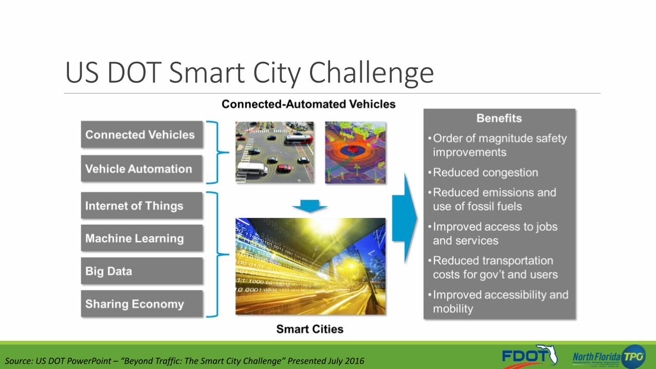
Smart Cities US DOT Smart City Challenge (2016)
◦ $40 Million from U.S. DOT
◦ 78 Applicants, 7 Finalists, 1 Winner
◦ Jacksonville Submitted Application
MetroLab ◦ City-university Partnerships
◦ Part of Smart Cities Initiative in Sept, 2015
◦ Projects in Northeast Florida: ◦ Jacksonville Emergency Response Mapping
◦ Jacksonville Bicyclist/Pedestrian Behavior Analysis
◦ Jacksonville Neighborhood Connectivity Analysis
Industry Efforts ◦ AT&T
◦ Cisco
◦ IBM
• Columbus, OH
Smart City Challenge Winner:
• Austin, TX
• Denver, CO
• Kansas City, MO
• Pittsburgh, PA
• Portland, OR
• San Francisco, CA
Smart City Challenge Finalists:

US DOT Smart City Challenge
Source: US DOT PowerPoint – “Beyond Traffic: The Smart City Challenge” Presented July 2016
US DOT Smart City Challenge
Source: US DOT PowerPoint – “Beyond Traffic: The Smart City Challenge” Presented July 2016

US DOT Smart City Challenge Technology Elements in Original Proposals
Source: US DOT PowerPoint – “Beyond Traffic: The Smart City Challenge” Presented July 2016

US DOT Smart City Challenge - Columbus
Source: Columbus, OH Smart City Application

Smart City Finalist Highlights – Transportation
Mobility challenge Encourage residents to explore alternative modes of transportation
Smartphone applications Quickly compare cost/travel time of different modes of transportation
Energy efficiency Electric vehicle charging stations, improved signal timings, etc.
Services for low income neighborhoods Better public transit options, free wi-fi in public places, etc.
Smart Network Deploy sensors that work together to provide a holistic understanding of the transportation system

US DOT Smart City Challenge Connect to Jax – C2JAX: A smarter, better Jacksonville (2016)
• Replace dated fiber optic cable
• Complete unconnected fiber optic runs
• Complete bluetooth traffic sensor network (BlueTOAD)
• GPS trackers in all public vehicles
Complete ITS Infrastructure
Foundation
• Wireless internet at each of 1,000 intersections
• Expand preemptive signal plan
• Expand smart sensor enabled street light system
• Complete BRT system to appeal to a wider base
Expand ITS Infrastructure
• Prepare for future technologies
• Bike/car share options
• Partner with apps such as Waze
• Intelligent light fixtures
Enhance Capabilities

State of the Practice - Transportation Transit
Bus Rapid Transit (BRT)
Personal Rapid Transit
(PRT)
Bike/Ped Safety
Connected Vehicle
Technology
Collision Detection Systems
Smartphone-Based
Applications
Mobility as a Service
Uber/Lyft
Bike Sharing
Car Sharing
Connected Vehicles
V2V with DSRC
V2I with DSRC
Cell-based
Connected Infrastructure
Autonomous Vehicles
Levels of Autonomy
Autonomous Shuttles
Autonomous Taxis
New Mobility
Internet of Things
Smart Parking
Smart Lighting
Traffic Signals

Smart City Components
Vehicle &
Infrastructure
Based Data
Local/Regional
Communications
Network
Data
Management
Data Integration
& Distribution
Data Analytics Actionable
Information
Informed
Decision
Des
crip
tio
n
•Roadway sensors • Cell data • Community input
(ie. Waze)
•Radio towers • Fiber network • Cell network
• State ATMS system • Emergency
dispatch system
• Central data warehouse
•Automated algorithms •Human analysis •Warning systems
•Modified signal timings •Updated travel
time info • Suggested
alternate routes •Dispatched
emergency vehicles
• Common congestion times • Frequent crash
locations

Discussion – North Florida Status
Challenges Today
Regional Changes
Challenges Tomorrow

Discussion – Challenges Today
Vehicle &
Infrastructure
Based Data
Local/Regional
Communications
Network
Data
Management
Data Integration
& Distribution
Data Analytics Actionable
Information
Informed
Decision

Discussion – Regional Changes
Vehicle &
Infrastructure
Based Data
Local/Regional
Communications
Network
Data
Management
Data Integration
& Distribution
Data Analytics Actionable
Information
Informed
Decision

Discussion – North Florida in 5, 10, 20 years
Transit Freight Bicycles/
Pedestrians Passenger
Cars

Next Steps – Schedule
Stakeholder Meeting 1
September 2016
Stakeholder Meeting 2
October 2016
Vision Statement Finalized
November 2016
Stakeholder Meeting 3
January 2017
TSM&O Master Plan
Finalized
February 2017

Other Key Dates • Drive Electric Week, North Florida TPO September 16, 2016
• Smart Cities Week, Washington, DC (http://www.smartcitiesweek.com/) September 27-29, 2016
• ITS World Congress, Melbourne, Australia October 10-14, 2016
• ITS Florida Annual Meeting & Expo November 13-17, 2016
• Florida Automated Vehicles Summit, Tampa, FL November 29-30, 2016
• Consumer Electronics Show, Las Vegas, NV January 5-8, 2017
• Transportation Research Board Annual Meeting, Washington, D.C. January 8-11, 2017

Contact Information
Greg Krueger, P.E. Director of Emerging Technologies HNTB Corporation 517.897.5841 [email protected]
Jeff Sheffield Executive Director North Florida TPO 904.306.7512 [email protected]
Peter Vega TSM&O Program Manager Florida Department of Transportation 904.360.5463 [email protected]