Embed Size (px)
Citation preview
To:JasonBahnsen–NorthernLightsResources
From:WilliamJ.TafuriPhD-ConsultingGeologist/EditedGaryJ.Artmont
Subject:MedicineSpringsGeologicalReport
Date:January26,2019
SummaryandConclusions
TheMedicineSpringsprojectofNorthernLightsResources isconsideredbytheauthor tohave veryhighpotentialtohostaCarbonateReplacementDeposit(CRD)ofPb,Zn,Ag.Historicdrillingattheprojectsitebypreviouscompanieshasdefinedasmall,possiblystratabound,resource(350,000tonsofoxidemineralizationaveragingagradeof2.3oz/tonAg).ValuesinPb,Zn,andbaritearealsomentionedinvariousreportswithvaryingvalues.ThehistoricGoldenPipeminehasproducedsmalltonnagesofPb,Zn,AgandbaritefromveinsinasmallundergroundoperationwheredikesofigneousrockwerefoundcuttingthehostlimestoneofthePermianGersterFm.Theexactamountofthetonnageandgradeoftheproductionisnotaccuratelyknown.While therehasbeenmuchdrillingontheprojectbyhistoricoperatorsmuchof thedrillinghasbeentooshallowtodefineanythingmorethanthesmallknownnearsurfaceAgdeposit.Adeeperholenorthoftheknownresource,JS-105,intersectednotablePb,Zn,Agmineralizationandconcealedintrusiverockbuthasnotbeenoffset.Areviewofthesurfacegeologyandlimitedsamplingbytheauthorhasdefinedanareaofveining and alteration similar to what occurs above the known resource over a strike distance ofapproximately2.4km(1.5miles)withawidthofapproximate0.8km(0.5mile).Therecentlycompleteddroneaero-magneticsurveybyNorthernLightsResourceshasoutlinedintrusiveswithinthevicinityoftheknownmineralization,close toHole JS105,andundercover inotheralteredareas. Allof thesepoints, thepastproduction,theknownunexploitedresource,drillholeswithpotentiallyeconomicinterceptsthathavenotbeenoffset,favorablehostrocks,andtheresultsoftherecentaero-magneticsurveylendcredencetothepossibilityofadditionalandpossiblylargerCRDdepositsbeingfoundontheprojectsite.
IntroductoryNotes
ThepreviousmappingbyCollinson,1968,isofveryhighqualityandveryfewchangeswerejustified.TheonlyplacesthatdifferfromwhatthisauthorsawiswheretheGPSenabledtheauthortomakemoreexactlocationsinthePinion-Juniperforestedareasorwhereabulldozermadeoutcropsinpreviouslycoveredareas.ThisauthordidnotattempttorepeattheworkofpreviousauthorsespeciallyindescribingthemineralizationintheNI43-101TechnicalReportbut insteadfocusedonthesurficialgeology,alterationandmineralization.NAD 27 coordinates are used throughout this report. US units of measurement are also used to avoidconfusionwiththehistoricalreports,drillrecords,andsurveysthataremeasuredinUSunits.
ConfusionovertheGoldenPipeandSilverButteMineNaming
TheterminologyusedontheMedicineSprings7.5minuteUSGStopographicmapiswhatisusedthroughoutthis report.TheGoldenPipeMine is theonlymine in theMudSpringsDistrictwithsignificantproductionwhereastheSilverButteMine,asidentifiedonthetopographicmap,islocatedapprox.1.5kmsouthoftheGoldenPipeMineandhasnothadrecordedproduction.TheSilverButteareaonlyconsistsofsmallprospect
pitsandshallowshafts.Apparently,theconfusionistheresultofearlyreportingwhichusedvariousnamesfortheGoldenPipesuchas:DeadHorseorSilverButte.SeveraloftheoldercompanyreportsandgovernmentpublicationsrefertotheSilverButtemine,butinreality,theyrefertowhatwenowcalltheGoldenPipe.TheDefenseMineralAdministration (DMA)mapswhich refer to theSilverButteMinematch theGoldenPipeundergroundworkingsandgeologynottheSilverButtegeology.
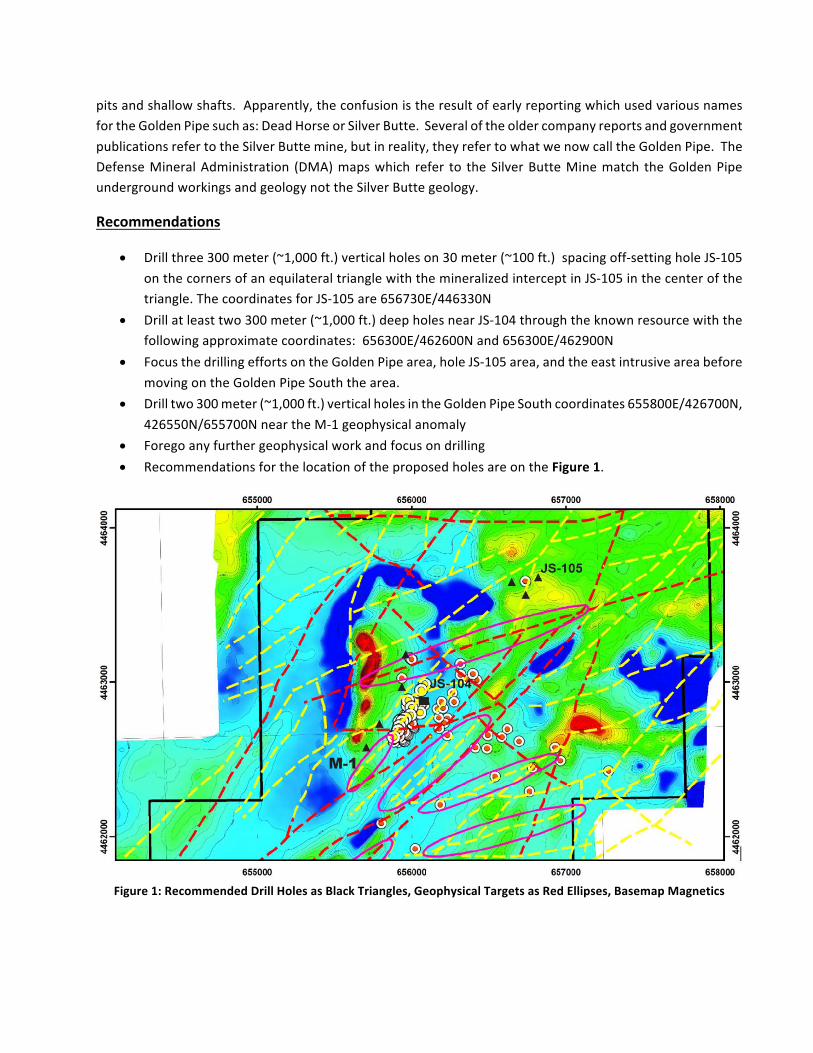
Recommendations
• Drillthree300meter(~1,000ft.)verticalholeson30meter(~100ft.)spacingoff-settingholeJS-105onthecornersofanequilateraltrianglewiththemineralizedinterceptinJS-105inthecenterofthetriangle.ThecoordinatesforJS-105are656730E/446330N
• Drillatleasttwo300meter(~1,000ft.)deepholesnearJS-104throughtheknownresourcewiththefollowingapproximatecoordinates:656300E/462600Nand656300E/462900N
• FocusthedrillingeffortsontheGoldenPipearea,holeJS-105area,andtheeastintrusiveareabeforemovingontheGoldenPipeSouththearea.
• Drilltwo300meter(~1,000ft.)verticalholesintheGoldenPipeSouthcoordinates655800E/426700N,426550N/655700NneartheM-1geophysicalanomaly
• Foregoanyfurthergeophysicalworkandfocusondrilling• RecommendationsforthelocationoftheproposedholesareontheFigure1.
Figure1:RecommendedDrillHolesasBlackTriangles,GeophysicalTargetsasRedEllipses,BasemapMagnetics
GeneralGeologicSetting
Thegeneralgeologicsettingoftheprojectiswelldescribedinvariousreportssotheauthorwillnotdwellonitherebutwillinsteadmakeafewcommentstosetthetoneofthefollowingobservations.OutcroppingrocksfortheknownmineralizationarelimestonesofthePermianGersterFm.whichatthislocalityarecomposedofgrayfossiliferousthinbeddedandinpartsandylimestones.TheGersterFm.isdisconformablyoverlainbytheTriassicThaynesFm.consistingofbufftoyellowishcoloredsandstone,limysandstoneandconglomerate.ThissequenceisoverlainbyrhyolitetiffsofthetertiaryHumboldtFm.TheThaynesandGersterFm.rockshavebeenextensivelyfaultedbyNEstrikingnormalfaultswhiletheHumboldtFm.hasnotbeendissectedbyfaulting.
IntrusiverocksofvarioustypeshaveintrudedtheThaynesandGersterFm.butnottheHumboldttuffs.Therearetwocentersofmineralization,theGoldenPipeAreaandtheSilverButtearea.OnlytheGoldenpipearehashadproductionandthatwasfromtheperiodbetween1930and1952.
OutcroppingIntrusives
Rhyolite
Asmallstockofrhyolite,ofprobableTertiaryage,intrudingtheuppermemberoftheThaynesFm.wasmappedbyCollinson,1968,andfieldcheckedbytheauthorat6577640E/608670N.Therhyoliteisaphaniticbrightwhiteandfreshwithplatyfracturingandappearstobenearoratthetopoftheintrusivebody.Outcropsintheareaarepoorbutthereisoneverysmalloutcropofrecrystalizedbutotherwisefreshlimestoneontherhyolitecontactat657973E/460763N.
VesicularBasalt
Thissmall,about200m2,outcropofvesicularbasalt,alsoofprobableTertiaryage,wasalsofirstidentifiedbyCollinson,1968,andfieldcheckedbytheauthorat657436E/459988N.Itisfreshandveryfinegrained.Eventhoughitismappedasaseriesofdikestheoutcropsarenotgoodenoughtoconfirmthis.Nosolidoutcropcouldbefoundbutthesurfaceareawaslitteredwithpiecesofthebasalt.
DioriteandGranodiorite
Severalworkers,startingwiththeDMA,1930,report,haveidentifiedasmallpartiallyconcealedoutcropofdiorite approximately 1,000 meters (1,600 ft.) NW of the Golden Pipe shaft, located approximately at656270E/463120N. Nodioritewasfoundatthis locationbutashallowprospectdidexposesomesandeddecomposedgraniticrockthatcouldhavebeenderivedfromafinegrainedgranodiorite.
TheprominentDelcerButtes situated to theNEof theproperty, are composedofdiorite in contactwithPaleozoicsediments.AsmallerseriesoflowgranodioritehillssurroundedbyalluviumarefoundtothewestoftheDelcerButtesformingprominentoutcropsinthealluvialvalleyapproximately10kmNNEoftheGoldenPipeShaftat658380E/471620N.
ConcealedIntrusives
DikeRockGoldenPipeDump
Fragmentsofgraycoloredfine-grainedporphyriticgranodioritecanbefoundoftheGPdump.Themodeofoccurrenceoftherockisnotknown.Themineworkingshavebeenmapped(DMA1930)butthemappingonlyshowsthelocationoftheworkings,faultsandveinsignoringthehostandintrusiverock.Therockconsistsofsmall, approx. 4-6mm in size, phenocrystsof quartz and feldspar in a very fine- grainedmatrixof quartz,feldspar,biotiteandhornblende.Someofthequartzphenocrystsarerimmedwithpyrite.Therearesomevery small irregularblackblebsof somemineral that is too finegrained tobe identifiedbut theyarenotmagnetite.
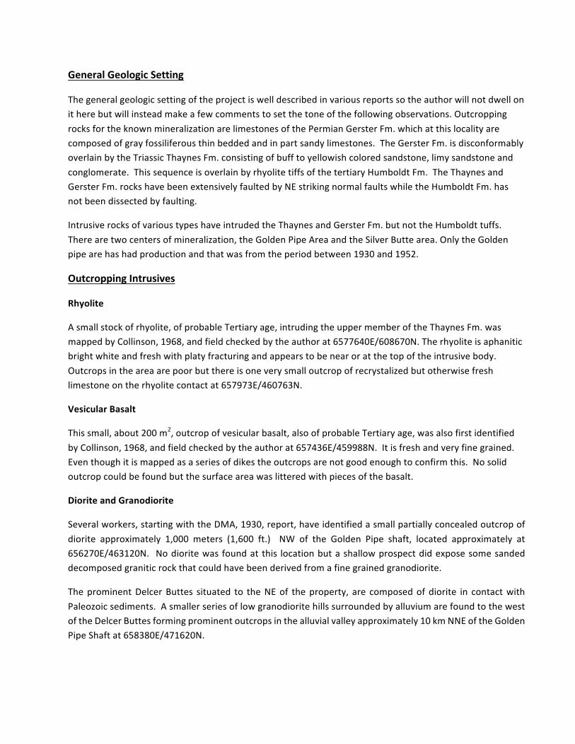
Granodiorite,thesmalldarkhillabovethebendintheroad,istheclosestoutcroppingintrusiverocktotheproperty.ThisphotowastakennearholeJS35lookingnortherly.
HoleJS-105
TheoftenreferredtoholeJS-105intersectedintrusiverockfromdownholeintervalfrom193meters(640ft.)to221meters(730ft.)andpossiblyto227meters(750ft.).Therockhasbeendescribedasastronglypropylitizedgraniteduetoitsgreencolor,abundantchloriteandafewscatteredremnantgrainsofpink
feldspar.Someintervalsarecutbycalciteveinswithsmallamountsoffinegrainedsphalerite.Eitherthecalciteveinsarepostintrusivemineralizationintroducedintocracksinthecooledintrusiveortheintrusivecouldbeacarbonatite.Ifthechipsareavailable,theyshouldbecarefullyexamined.
Stratigraphy
HumboldtFm.
TheupperMioceneHumboldtFm.tuffsoutcropinthenorth,westandeastendsoftheproperty.Thetuffsareextremelyheterogeneouswithnomarkerbeds.TheHumboldtFm.hasbeendividedintothreeinformalunitswithonlythemiddletuffsequencebeingintheprojectarea.Ingeneral,thelowerunitexposedonthepropertyiscomposedofwhiterhyolitetuffwhichisconformablyoverlainbytanrhyolitetuff.Thetuffshavebeenagedated,bythefissiontrackmethodinzircongrains,at9.5my+/-1.9my,Coats,1985.Bothunitsarepoorlyconsolidatedandeasilyeroded.Thetanunitiscomposedoftuffaceousrhyoliticsandstone,layeredtuffs,conglomerate,andpodsoftantograyfossiliferouslimestone.Notetheheterogeneityinthesecondphotographbelow.TheHumboldtFm.tuffsarenothydrothermallyalteredbuttheymaybedevitrifiedbysupergenewaterinplaces.
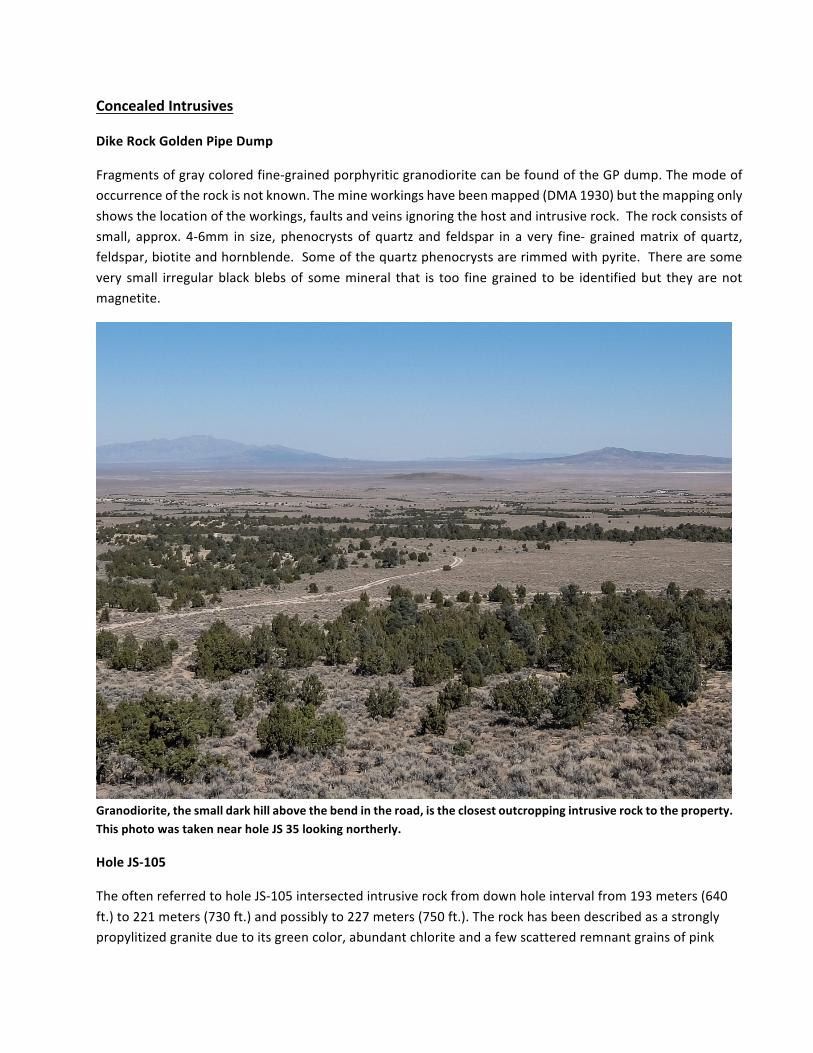
ThetanupperpartoftheHumboldtFm.andthewhitelowerpartoftheHumboldtFm.asseenontheeastedgeoftheproject.
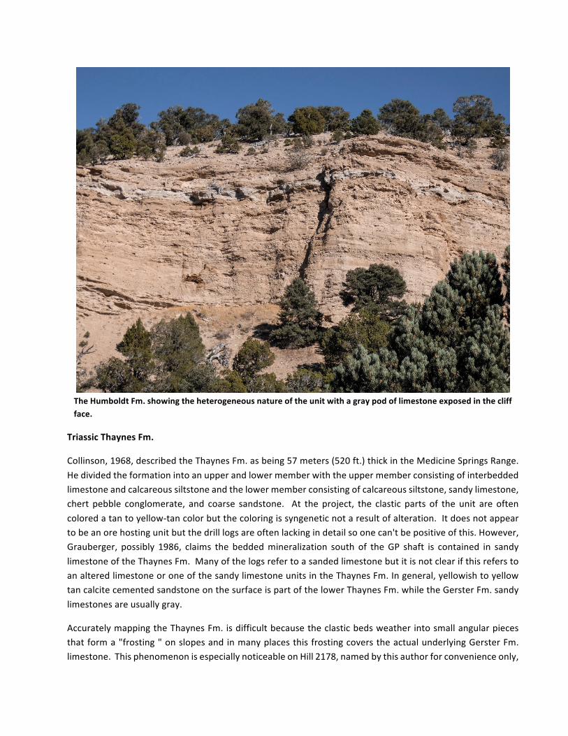
TheHumboldtFm.showingtheheterogeneousnatureoftheunitwithagraypodoflimestoneexposedinthecliffface.
TriassicThaynesFm.
Collinson,1968,describedtheThaynesFm.asbeing57meters(520ft.)thickintheMedicineSpringsRange.Hedividedtheformationintoanupperandlowermemberwiththeuppermemberconsistingofinterbeddedlimestoneandcalcareoussiltstoneandthelowermemberconsistingofcalcareoussiltstone,sandylimestone,chert pebble conglomerate, and coarse sandstone. At the project, the clastic parts of the unit are oftencoloredatantoyellow-tancolorbutthecoloringissyngeneticnotaresultofalteration.Itdoesnotappeartobeanorehostingunitbutthedrilllogsareoftenlackingindetailsoonecan'tbepositiveofthis.However,Grauberger, possibly 1986, claims the beddedmineralization south of theGP shaft is contained in sandylimestoneoftheThaynesFm.ManyofthelogsrefertoasandedlimestonebutitisnotclearifthisreferstoanalteredlimestoneoroneofthesandylimestoneunitsintheThaynesFm.Ingeneral,yellowishtoyellowtancalcitecementedsandstoneonthesurfaceispartofthelowerThaynesFm.whiletheGersterFm.sandylimestonesareusuallygray.
AccuratelymappingtheThaynesFm.isdifficultbecausetheclasticbedsweatherintosmallangularpiecesthatforma"frosting"onslopesandinmanyplacesthisfrostingcoverstheactualunderlyingGersterFm.limestone.ThisphenomenonisespeciallynoticeableonHill2178,namedbythisauthorforconvenienceonly,
afterthemetricspotelevationonthetopofthehilltotheNWtoGoldenPipeShaft. AdrillroadheadingalongtheSWflankofHill2178exposedGersterFm.limestonewhichiscoveredbyThaynesFm.clasticrocktalusandmappedasThaynesFm.byCollinson.ThiscommentisnotacriticismofCollinson,hedidnothaveabulldozerorGPStomapwithin1968.
PermianGersterFm.
MineralizationatMedicineSpringsishostedinthePermianGersterFormation.Bissel,1964,describedthesectionintheMedicineSpringsMountainsasbeing1269meters(4,190ft.)thick.However,Collinson,1968,describedthesectionasbeingonly363meters(1,200ft)thickhavingbeenrepeatedseveraltimesbyfaulting.This author agrees with Collinson after seeing many apparently repeated sequences on the property.However,therepetitivenatureofthesedimentationandthepossiblefaultduplicationofthesectionmakesitdifficultifnotimpossibletoidentifyeithermarkerbedsorfaultrepetitionanditispossiblethatBissellwascorrect.Therepetitivesedimentarysequenceandpossibleidentificationofmarkerbedsmaybeclarifiedbycarefullymeasuringsections.Thiswouldbeanexpensiveendeavorwithoutmuchreturnontheinvestment.SinceMedicineSpringsisaminingprojectandnotanacademicexercise,itisbettertolookformarkersinthedrilling.
ThefossilassemblageintheGersterFm.limestone(brachiopods,bryozoans,crinoids,sponges)pointstoashallowwarmwaterdepositionalsetting.Theshallowwatersedimentation incombinationwithrepetitiverockunitsandtheoccasionalfinegrainedandwellsortedsandgrainsinsomebedswithoccasionalsiltlayerspointstoapossiblydeltaicdepositionalsetting.Thenatureofdeltaicsequencesalsomakesforpoorhorizontalcontinuitywhichcontributestothedifficultyincorrelatingunitsandmappingmarkerbeds.
ThethinbeddedporousandpermeablenatureoftheGersterFm.atMShasaverystrongresemblancetotheTopliffMemberof theMississippianageGreatBlueFm.atMercur,UTwhich is theorehost for thegoldmineralization,adepositIamveryfamiliarwith.Itisthesetypesofphysicalcharacteristicsthatmakeitsuchagoodorehost.Therock isnotonlyreceptivetomineralizingfluidsalongbeddingdiscontinuitiesbuttheclasticmaterial,eithersandgrainsorfossilsthatresistreplacementkeeptherockfabricopentotheingressofmineralizingfluids.
The repetitive nature of theGerster Fm. is depicted inFigure 2, publishedbyBissell, 1964. Bissell, 1964,describesadisconformitybetweentheTriassicThaynesandtheunderlyingPermianGerster.Thisisdifficulttoproveonsitebecauseofthefaultingandpoororabsentoutcropsincriticalareas.However,onHill2178tothewestof theGoldenPipe, thecontactbetweentheThaynesFm.andtheGersterFm.appears tobephysicallyconformablebutonlyastratigraphyfamiliarwiththefossilassemblagecouldproveanagegapinthesedimentation.ThiswouldplacethetopoftheGersterFm.atthatlocalitythushavingapproximately365meters(1,200ft.)ormoreoffavorableGersterFm.lyingbelow.Buttheblockfaultingonthepropertycanchangethispicturedramaticallyinjustafewmeters.OnlydrillingcandefinethetruethicknessoftheGersterFm.onsite,butIamnotrecommendingdrillingastratigraphicholetoclarifythissituation.
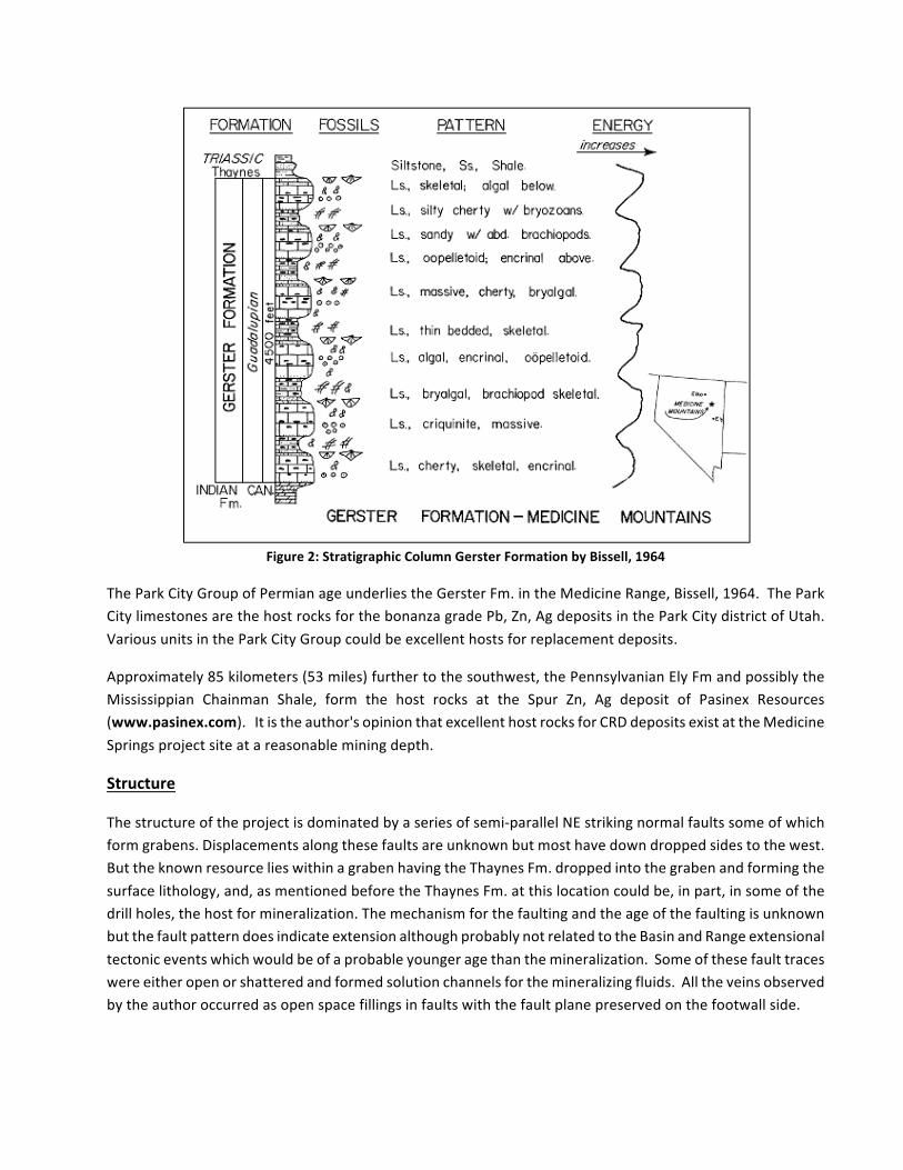
Figure2:StratigraphicColumnGersterFormationbyBissell,1964
TheParkCityGroupofPermianageunderliestheGersterFm.intheMedicineRange,Bissell,1964.TheParkCitylimestonesarethehostrocksforthebonanzagradePb,Zn,AgdepositsintheParkCitydistrictofUtah.VariousunitsintheParkCityGroupcouldbeexcellenthostsforreplacementdeposits.
Approximately85kilometers(53miles)furthertothesouthwest,thePennsylvanianElyFmandpossiblytheMississippian Chainman Shale, form the host rocks at the Spur Zn, Ag deposit of Pasinex Resources(www.pasinex.com).Itistheauthor'sopinionthatexcellenthostrocksforCRDdepositsexistattheMedicineSpringsprojectsiteatareasonableminingdepth.
Structure
Thestructureoftheprojectisdominatedbyaseriesofsemi-parallelNEstrikingnormalfaultssomeofwhichformgrabens.Displacementsalongthesefaultsareunknownbutmosthavedowndroppedsidestothewest.ButtheknownresourcelieswithinagrabenhavingtheThaynesFm.droppedintothegrabenandformingthesurfacelithology,and,asmentionedbeforetheThaynesFm.atthislocationcouldbe,inpart,insomeofthedrillholes,thehostformineralization.ThemechanismforthefaultingandtheageofthefaultingisunknownbutthefaultpatterndoesindicateextensionalthoughprobablynotrelatedtotheBasinandRangeextensionaltectoniceventswhichwouldbeofaprobableyoungeragethanthemineralization.Someofthesefaulttraceswereeitheropenorshatteredandformedsolutionchannelsforthemineralizingfluids.Alltheveinsobservedbytheauthoroccurredasopenspacefillingsinfaultswiththefaultplanepreservedonthefootwallside.
Micon International UK, April 2018, produced a block model and sections of the known mineralizationdepictingNEstrikingfaultoffsetsofthemineralizedzones.SincethesectionsareorientedNW-SEalongthelines of drill holes it be very difficult to show any possible NW-SE fault offsets. However, from surfaceobservations,thefaultscontrollingthemineralizationallappeartobeorientedtotheNEexceptfortheSilverButteareawheresomeNEtoEasterlystrikingfaultscontaintheusualbarite,jasperoid,gossanmineralization.NEstrikingfaultsprobablyexistinotherareasbutareprobablyconcealedbyalluviumortalus.
Mineralization
Therearetwomaincentersofmineralization,theGoldenPipeareawheretheidentifiedresourceislocatedand the SilverButte areawhere there is no known resource.However, these twoarea are connectedbysporadicmineralized veins cutting theGerster Fm. TheGolden Pipemineralized area has vein controlledmineralization on the surface and underground in theGolden PipeMine and replacementmineralizationoutlined by the historic drilling in the near subsurface. The Silver Butte area has only vein-controlledmineralizationonthesurfacebut,exceptforone19-meter(60ft.)hole,JS-29,ithasnotbeendrilledsothepossibilityofbedding-controlledreplacementdepositscan'tbeentirelydiscounted.
DrillholeJS-29had13-15ppmAginthebottom6meters(20ft.)oftheholeanddetectableAgfortheentirehole.Thelogsarepoorlydescribedbuttheholeappearstohaveintersectedajasperoidveinatthemineralizedinterval.Theholewasplacedclosetoofaclusterofprospectsandprobablyhitthedowndipextensionofoneoftheneighboringveins.
TheSilverButtesurfaceisapproximately300meters(1,000ft)inelevationabovetheGoldenPipesurfacebutthemineralizationappearstobeinsamesequenceofrocks.Jasperoidveinswithgossanandbariteappeartobesimilar to thoseabovetheresource to thesouthofGoldenPipe. Perhaps theSilverButteareahasreplacementorbeddingcontrolledmineralizationatdepthbuttherehasbeennodrillingdeepenoughtotestthispossibility.IfthemineralizationatGoldenPipeiscontrolledbyafavorablepressure/temperatureregimeitwouldtakea1,000ft.deepdrilltesttojusthitthetopofthesamefavorablepressure/temperaturezoneunlessunseenfaultingupliftedtheSilverButteareatoitspresentposition.
SphaleritemineralizationwasonlyobservedbypreviousworkersinholesJS40,JS104andJS105.InholeJS40 an unidentified gray sulfide was observed at 17-19meters (70-75 ft.). In hole JS 104 sphalerite wasobservedatapproximately103-106meters(340-350ft.)downhole,or51meters(170ft.)belowthesurfaceandagainfrom156-159meters(515to520ft.).Sphaleriteandpyritewassporadicallyencounteredfrom125-227meters(414-750ft.)inholeJS105insomeplacesthesphaleritewasestimatedtobeupto12%.Sporadicintervalsof sphalerite in calcite veinswerealsodescribed in thehole. Sphalerite in calcite veins inwhatappearstobeagraniteintrusiveisanimportantoccurrencethatshouldbeinvestigated.Eitherthesphalerite-calcite veins were formed in a cooled and cracked granite or the "granite" may be a carbonitite. Thedescriptionofthe"granite"isweakandleavesmuchtospeculation.Ifthecalciteveiningislaterthanthe"granite"thensoisthemineralizationwhichmaybeanimportantpointtoconsiderinfurtherexplorationoftheproperty.
SulfideswerenotfoundinoutcropexceptforpartiallyoxidizedgalenainsomeoftheveinsimmediatelytothewestoftheSilverButteareanear655200E/461270NandontheSilverButteshaftdump.
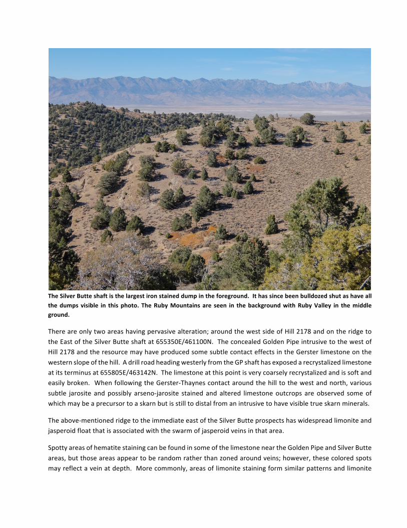
TheSilverButteshaftisthelargestironstaineddumpintheforeground.Ithassincebeenbulldozedshutashaveallthedumps visible in this photo. TheRubyMountains are seen in thebackgroundwithRubyValley in themiddleground.
Thereareonlytwoareashavingpervasivealteration;aroundthewestsideofHill2178andontheridgetotheEastoftheSilverButteshaftat655350E/461100N.TheconcealedGoldenPipeintrusivetothewestofHill2178andtheresourcemayhaveproducedsomesubtlecontacteffectsintheGersterlimestoneonthewesternslopeofthehill.AdrillroadheadingwesterlyfromtheGPshafthasexposedarecrystalizedlimestoneatitsterminusat655805E/463142N.Thelimestoneatthispointisverycoarselyrecrystalizedandissoftandeasilybroken. WhenfollowingtheGerster-Thaynescontactaroundthehilltothewestandnorth,varioussubtle jarosite andpossibly arseno-jarosite stained and altered limestoneoutcrops areobserved someofwhichmaybeaprecursortoaskarnbutisstilltodistalfromanintrusivetohavevisibletrueskarnminerals.
Theabove-mentionedridgetotheimmediateeastoftheSilverButteprospectshaswidespreadlimoniteandjasperoidfloatthatisassociatedwiththeswarmofjasperoidveinsinthatarea.
SpottyareasofhematitestainingcanbefoundinsomeofthelimestoneneartheGoldenPipeandSilverButteareas,butthoseareasappeartoberandomratherthanzonedaroundveins;however,thesecoloredspotsmayreflectaveinatdepth.Morecommonly,areasoflimonitestainingformsimilarpatternsandlimonite
may formhalos outward fromveins and it appears to diffuse further outward fromveins thanhematite.Limonitemaycontainanomalouschemistrywhereasthehematiteisusuallybarren.
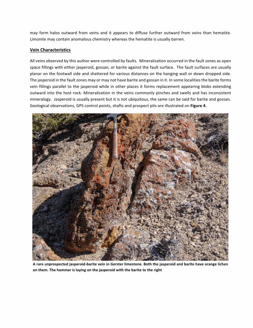
VeinCharacteristics
Allveinsobservedbythisauthorwerecontrolledbyfaults.Mineralizationoccurredinthefaultzonesasopenspacefillingswitheitherjasperoid,gossan,orbariteagainstthefaultsurface.Thefaultsurfacesareusuallyplanaronthefootwallsideandshatteredforvariousdistancesonthehangingwallordowndroppedside.Thejasperoidinthefaultzonesmayormaynothavebariteandgossaninit.Insomelocalitiesthebariteformsveinfillingsparallel tothe jasperoidwhile inotherplaces it formsreplacementappearingblobsextendingoutward intothehostrock.Mineralization intheveinscommonlypinchesandswellsandhas inconsistentmineralogy.Jasperoidisusuallypresentbutitisnotubiquitous,thesamecanbesaidforbariteandgossan.Geologicalobservations,GPScontrolpoints,shaftsandprospectpitsareillustratedonFigure4.
Arareunprospectedjasperoid-bariteveininGersterlimestone.Boththejasperoidandbaritehaveorangelichenonthem.Thehammerislayingonthejasperoidwiththebaritetotheright
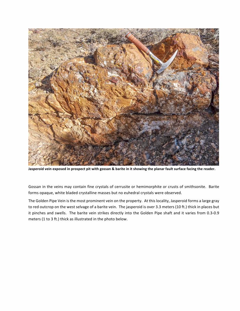
Jasperoidveinexposedinprospectpitwithgossan&bariteinitshowingtheplanarfaultsurfacefacingthereader.
Gossanintheveinsmaycontainfinecrystalsofcerrusiteorhemimorphiteorcrustsofsmithsonite.Bariteformsopaque,whitebladedcrystallinemassesbutnoeuhedralcrystalswereobserved.
TheGoldenPipeVeinisthemostprominentveinontheproperty.Atthislocality,Jasperoidformsalargegraytoredoutcroponthewestselvageofabaritevein.Thejasperoidisover3.3meters(10ft.)thickinplacesbutitpinchesandswells. Thebariteveinstrikesdirectly intotheGoldenPipeshaftand itvariesfrom0.3-0.9meters(1to3ft.)thickasillustratedinthephotobelow.
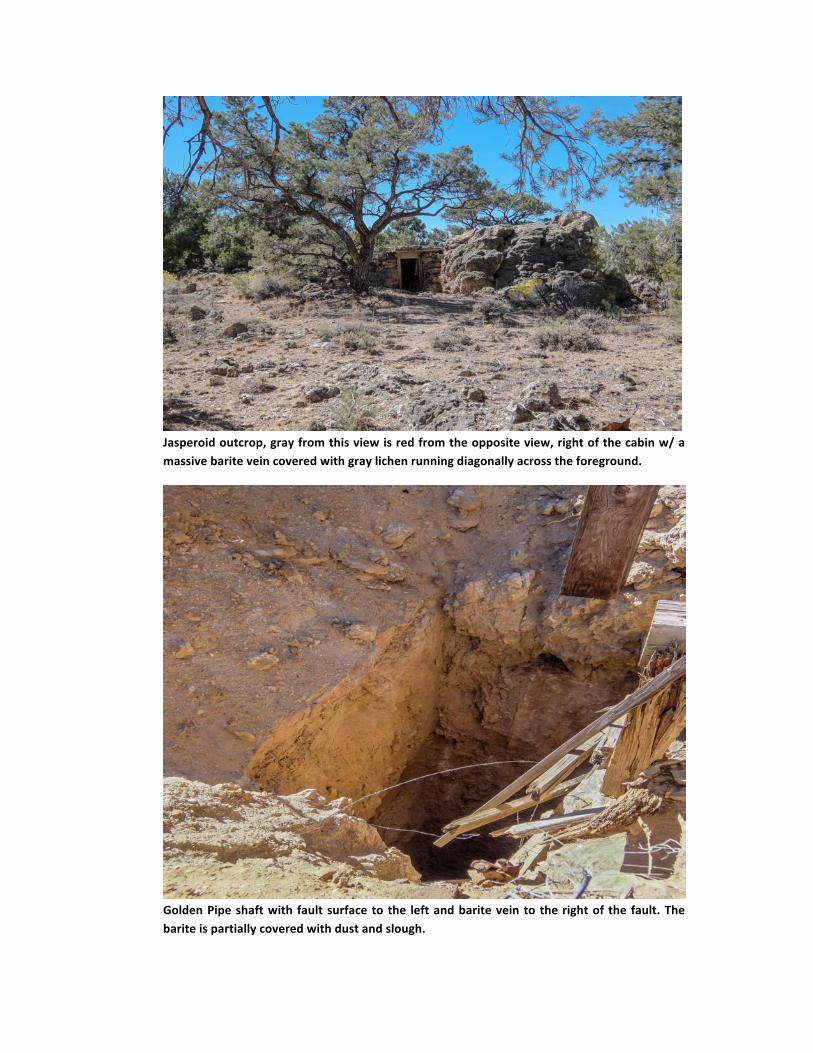
Jasperoidoutcrop,grayfromthisviewisredfromtheoppositeview,rightofthecabinw/amassivebariteveincoveredwithgraylichenrunningdiagonallyacrosstheforeground.
GoldenPipeshaftwith faultsurfacetothe leftandbariteveintotherightof the fault.Thebariteispartiallycoveredwithdustandslough.
Geochemistry
TherocksamplingwasnotintendedtobecomprehensivebecauseNorthernLightshadaverycomprehensivegeochemicalsoilsurveybeingcarriedout.Thiswasintendedtoseeiftherewasadifferenceinthevariousareasofthepropertythatmaygivesrisetoavectorpointingtowardadrilltargetandtoseeiftherewerefundamentaldifferencesinmineralizationthroughouttheprojectarea.Veinmaterialanddumpsampleswereanalyzed,andnoattemptwasmadetotryandcollectchannelsamples.Dumpsampleswerecollectedfromthemostalteredrock,usuallygossanorbarite-richrock.
AsillustratedonFigure5,atotalof43surfacesampleswerecollectedintheconcessionareaand2outsideto the west. Statistically significant conclusions would not be valid, however some potentially significantconclusionscanbedrawn.First,thereisnogolddetectedinthesystem,thisissurprisingbecausemostoftheCRDdepositsinNevadahavegoldinthem,forexample,thenearbyEurekadistrictlocated150kilometerstothesouth.Secondly,thesamplescollectedinthevicinityoftheGoldenPiperesource(samples5-10,13,41),samplesabovetheconcealedintrusive(samples3,4)andtheconcealedintrusivetotheeastoftheGoldenPipe(samples11,29,44,45)havegenerallyhigherMo,Sn,andWthanthesamplescollectedinthevicinityof Silver Butte (samples 14-25, 28, 35-37). This probably reflects the contact effects of the concealedintrusivesorsomeintroducedmagmaticcomponent.However,aveinsystem(definedbysamples26,27,30,31,32,38,39,40) immediatelytotheeastoftheSilverButteareahaselevatedWwithspottyelevatedvaluesofSnandMo.ThesourceoftheseelevatedelementsisnotobviousonthemagneticsurveyunlesstheveindipsintothemagnetichighfeaturestothewestofSB.Theveindoesdipwesterlysothisispossible.
SilverisassociatedwithPbandSb.WhileSbandBiarepresenttheirconcentrationisverylow.Arsenichasareverse correlationwithAgandwith the lowSbandBi probably indicates that sulfosaltminerals arenotassociated with the Ag mineralization. But these correlations are not perfect and there is considerablevarianceintheresults.Zincvarieswidelyprobablyreflectingtheremovalofmuchofthezincduringoxidation.Copperisverylowthroughoutthesystem.AluminumK,andNaareverylowwhichcorrelateswiththelackofsericiteobservedinthemineralizedveins.ThehighPinallareasoftheprojectisinterestinginthatthiscouldindicatesomeinputtothehydrothermalsystemfromunderlyingblackshale.PhosphaticblackshaleisknowninthePermiansectionineasternNevadabutthedepthtoitisunknownatthislocality.MercuryconcentrationsarehigherandwithwidervarianceatGoldenPipethanatSilverButteandverylowattheeasternintrusive.TheremaybearoughcorrelationofHgandAgbutitwouldtakemuchmoresamplingtobesureofthis.Thevery lowMg indicatesavery lowcontributionbydolomite intheareaandalsomay indicatethattheintrusives intheareaarenotmafic.Theauthortestedmany limestonesampleswithdiluteHClanddidn'tidentify any dolomite on the surface, but it is mentioned in some of the drill logs and the stratigraphicreferences.
ThesamplecoordinatesanddescriptionsandtheselectedassayresultsarefoundinAppendixAandB.ThesampleswereanalyzedusingICP-MSfor35elementsbyALSinVancouver,Canada.
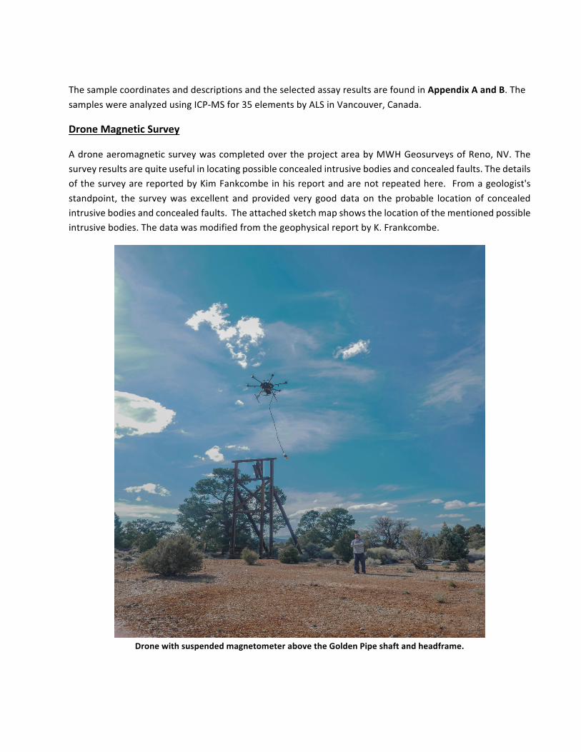
DroneMagneticSurvey
AdroneaeromagneticsurveywascompletedovertheprojectareabyMWHGeosurveysofReno,NV.Thesurveyresultsarequiteusefulinlocatingpossibleconcealedintrusivebodiesandconcealedfaults.ThedetailsofthesurveyarereportedbyKimFankcombeinhisreportandarenotrepeatedhere. Fromageologist'sstandpoint, the surveywas excellent andprovided very gooddataon theprobable locationof concealedintrusivebodiesandconcealedfaults.Theattachedsketchmapshowsthelocationofthementionedpossibleintrusivebodies.ThedatawasmodifiedfromthegeophysicalreportbyK.Frankcombe.
DronewithsuspendedmagnetometerabovetheGoldenPipeshaftandheadframe.
Aprobabledike-likeintrusive,theGoldenPipeIntrusive,liesundercovertothewestoftheknownresource.Piecesofafine-grainedgranodioriteporphyrycanbefoundontheGoldenPipeminedumpanditismappedintwoplacesonthesurfacebytheDMA,1930.Theareabetweentheintrusiveandtheknownresourcewouldbeveryfavorableforthe locationofaTaylor-typeofskarnandshouldbedrilledwithat leastthreeholesparalleltotheknownresourceandsplittingthedistancebetweentheintrusiveandtheresource.
ThetopofaprobablesmallintrusivestocklaysunderholeJS-105whichintersectedapropylitizedsphaleritebearing"granite"dike(?).ApropylitizedgraniteprobablywouldnothaveamagneticsignaturesothecauseoftheanomalyisenigmaticbutthisoccurrenceshouldbeaggressivelydrilledwithatleastthreedrillholesspacedsymmetricallyaroundholeJS-105. Again,thisoccurrencecouldbethelocationofaTaylor-typeofskarndeposit
Aprobable intrusivewas locatedunder the flatalluvial area to theEastof the resource. Thedumpofaprospectshaftclosetotheedgeof theprobable intrusivehadveryhard fine-grainedcrystallinerockwithsporadicbaritewhichcouldbearockslightlydistaltoaskarn.Thisareashouldbedrilledafterthefirsttwomentionedtargetshavebeendrilledandthatknowledgeusedtospotwelllocatedholeshere.
ThemagneticsurveyrevealedconcealeddikesbelowthemineralizedjasperoidveinsatWestSilverButte.ThedikeshaveaNNEstrikesimilartothefaulttrendsinthearea. Drillingisrecommendedherebutafterthepreviouslymentionedhavebeendrilled.
Amoredetailedgeologicanalysisofthemagneticsurveywillfollow.AsillustratedonFigure5,outlineoftheprobableintrusivebodiesisdefinedbythemagneticanalyticalsignal.TheoutlinesweretakenfromtheK.Frankcombegeophysicalreport.
ReinterpretationofHistoricCSAMTSurvey
ThehistoricCSAMTsurveywasreinterpretedbyKimFrankcombeofExploreGeoPtyLtdfromscannedsections.NothavingtheoriginaldigitaldatawasahandicapbutKimmadeaverygoodattempttosalvageasmuchinformationaspossible.Whilenodirectevidenceformineralizationwasuncoveredthesurveymaynotbetotallyuseless.Futuredrillingmayyielddatathatcouldbeusedtofurtherrefinetheresults.Forexample,Figure10takenfromKimFrankcombe’sgeophysicalreport,illustratedinFigure3,showsazoneofmodestlyelevatedresistivitywheretheknownresourceislocated.
HoleJS-104theonlydeepangleholeintheresourcepenetratesthroughtheresourceandthenstopsshortofasimilarzoneofmodestlyelevatedresistivity.Perhapsaholepenetratingthisconcealedzonecandefinewhatitis,possiblyanothermineralizedzone.Furthertothesoutheastalongthecrosssectionlinethedrillingstopsshortofadippingzoneofsimilarelevatedresistivityandevenfurthertothesoutheasttwoholescomeclosetobutdonotpenetrateastronglyresistivezone.Sincethemineralizationisassociatedwithjasperoid,averyhighlyelectricallyresistiverock,theseresistorsshouldbeaggressivelyinvestigated.ThereareotherexamplestobenotedintheCSAMTreinterpretationandafewquickverticaldrillholescanclarifythis.Afurthergeology-basedanalysesoftheCSAMTdatainconjunctionwiththemagneticdatawillbemadebythisauthorinthenearfuture.
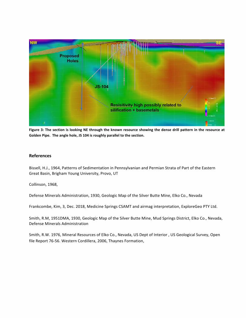
Figure3:Thesection is lookingNEthroughtheknownresourceshowingthedensedrillpattern intheresourceatGoldenPipe.Theanglehole,JS104isroughlyparalleltothesection.
References
Bissell,H.J.,1964,PatternsofSedimentationinPennsylvanianandPermianStrataofPartoftheEasternGreatBasin,BrighamYoungUniversity,Provo,UT
Collinson,1968,
DefenseMineralsAdministration,1930,GeologicMapoftheSilverButteMine,ElkoCo.,Nevada
Frankcombe,Kim,3,Dec.2018,MedicineSpringsCSAMTandairmaginterpretation,ExploreGeoPTYLtd.
Smith,R.M,1951DMA,1930,GeologicMapoftheSilverButteMine,MudSpringsDistrict,ElkoCo.,Nevada,DefenseMineralsAdministration
Smith,R.W.1976,MineralResourcesofElkoCo.,Nevada,USDeptofInterior,USGeologicalSurvey,OpenfileReport76-56.WesternCordillera,2006,ThaynesFormation,
Appendices
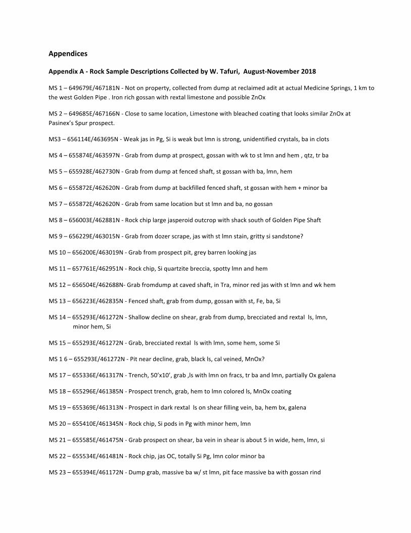
AppendixA-RockSampleDescriptionsCollectedbyW.Tafuri,August-November2018
MS1–649679E/467181N-Notonproperty,collectedfromdumpatreclaimedaditatactualMedicineSprings,1kmtothewestGoldenPipe.IronrichgossanwithrextallimestoneandpossibleZnOx
MS2–649685E/467166N-Closetosamelocation,LimestonewithbleachedcoatingthatlookssimilarZnOxatPasinex’sSpurprospect.
MS3–656114E/463695N-WeakjasinPg,Siisweakbutlmnisstrong,unidentifiedcrystals,bainclots
MS4–655874E/463597N-Grabfromdumpatprospect,gossanwithwktostlmnandhem,qtz,trba
MS5–655928E/462730N-Grabfromdumpatfencedshaft,stgossanwithba,lmn,hem
MS6–655872E/462620N-Grabfromdumpatbackfilledfencedshaft,stgossanwithhem+minorba
MS7–655872E/462620N-Grabfromsamelocationbutstlmnandba,nogossan
MS8–656003E/462881N-RockchiplargejasperoidoutcropwithshacksouthofGoldenPipeShaft
MS9–656229E/463015N-Grabfromdozerscrape,jaswithstlmnstain,grittysisandstone?
MS10–656200E/463019N-Grabfromprospectpit,greybarrenlookingjas
MS11–657761E/462951N-Rockchip,Siquartzitebreccia,spottylmnandhem
MS12–656504E/462688N-Grabfromdumpatcavedshaft,inTra,minorredjaswithstlmnandwkhem
MS13–656223E/462835N-Fencedshaft,grabfromdump,gossanwithst,Fe,ba,Si
MS14–655293E/461272N-Shallowdeclineonshear,grabfromdump,brecciatedandrextalls,lmn, minorhem,Si
MS15–655293E/461272N-Grab,brecciatedrextallswithlmn,somehem,someSi
MS16–655293E/461272N-Pitneardecline,grab,blackls,calveined,MnOx?
MS17–655336E/461317N-Trench,50’x10’,grab,lswithlmnonfracs,trbaandlmn,partiallyOxgalena
MS18–655296E/461385N-Prospecttrench,grab,hemtolmncoloredls,MnOxcoating
MS19–655369E/461313N-Prospectindarkrextallsonshearfillingvein,ba,hembx,galena
MS20–655410E/461345N-Rockchip,SipodsinPgwithminorhem,lmn
MS21–655585E/461475N-Grabprospectonshear,baveininshearisabout5inwide,hem,lmn,si
MS22–655534E/461481N-Rockchip,jasOC,totallySiPg,lmncolorminorba
MS23–655394E/461172N-Dumpgrab,massivebaw/stlmn,pitfacemassivebawithgossanrind
MS24–655418E/461132N-SilverButteNorthshaft,grabfromdump,heavylmngossanwithminorba, somegalena
MS25-655421N/461123E-SilverButteSouthshaft,grabfromdump,gossanwithbaandheavylmn
MS26-655555N/460927E-Dumpgrab,prospectonshear,lmncoloredjaswithba
MS27-655544N/461083E-Rockchip,lmn,hemcoloredjaswithminorba
MS28–655109E/461381N-Dumpgrabfromprospectpit,MnOxcoveredconglomeratewithroundedsmallpebbles,noCO3,ba,possiblerhyolitefragments,faultbreccia,abundantsimilarrocksinarea
MS29-656799N/462720N-DumpgrabfromprospectpitinPg,gossanwithhem,lmn,ba
MS30–655583E/461124N-Dumpgrabfromcribbedprospectpit,lswithstlmn,minorhemandMnOx,ba,structureisobscuredbutslickensidesarefoundonthedump
MS31–655596E/461137N-Dumpgrabfromprospectpit,jaswithstlmnandwkhemandba
MS32–655441E/460704N-Dumpgrabfromdeepprospectpitinls,lmncoloredjaswithba,wkhem
MS33–655792E/460818N-Dumpgrabonmassivebaveinabout5ft.wide,zonesofwklmncoloredjasandMnOx
MS34 655124E/461159N-Dumpgrab,pitinrextalls,smallfaultwith1ft.ofgougeminorlmnnovisibleba
MS35–655131E/461151N-Grabfromtrenchonfault,heavygossanwithlmn,hem,MnOx
MS36–655170E/460909N-Grabfromroadcut,massivebaveinabout6ft.thick,mainlylmngossan
MS37–655170E/460909N-Grabofmassivebaritevein
MS38–655711E/461331N-Rockchip,OC,lmncoloredjaswithtracehem,minorba
MS39–655853E/461580N-Grabpitonmassivebavein,ba,lmncoloredgossan,tr.hem,tr.MnOx
MS40–655942E/461641N-Trenchandaditonsamevein,grabfromapparentstockpile,lmngossan,tr. hem,ba
MS41- 655898E/462662N-OCrockchipofTrafinegrainedsandstonewithlmnstain
MS42–656058E/462771N-OCrockchipofPg,hemstainednoba
MS43–656052E/461982N-Dumpgrabtrenchonbaveins,veinshaveSiselvagewithlmncoloredgossan
MS44–656935E/462597N-Deepshaft,dumpgrab,hem/lmngossan,minorba,qtzinvugsandveinlets,hardrextallmaybeaskarnprecursor.
MS45–656886E/462454N-Drillroadpossiblyhole35,Grab,somelmnjas,heminPgminorSi,tr.Ba
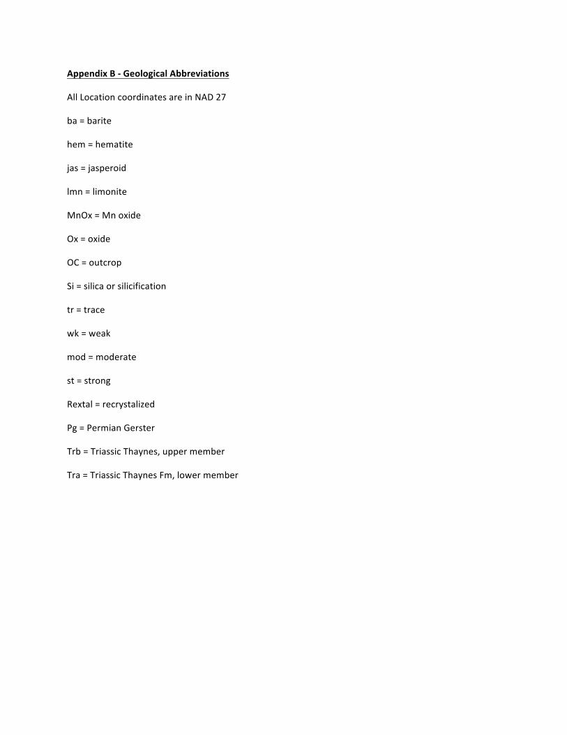
AppendixB-GeologicalAbbreviations
AllLocationcoordinatesareinNAD27
ba=barite
hem=hematite
jas=jasperoid
lmn=limonite
MnOx=Mnoxide
Ox=oxide
OC=outcrop
Si=silicaorsilicification
tr=trace
wk=weak
mod=moderate
st=strong
Rextal=recrystalized
Pg=PermianGerster
Trb=TriassicThaynes,uppermember
Tra=TriassicThaynesFm,lowermember
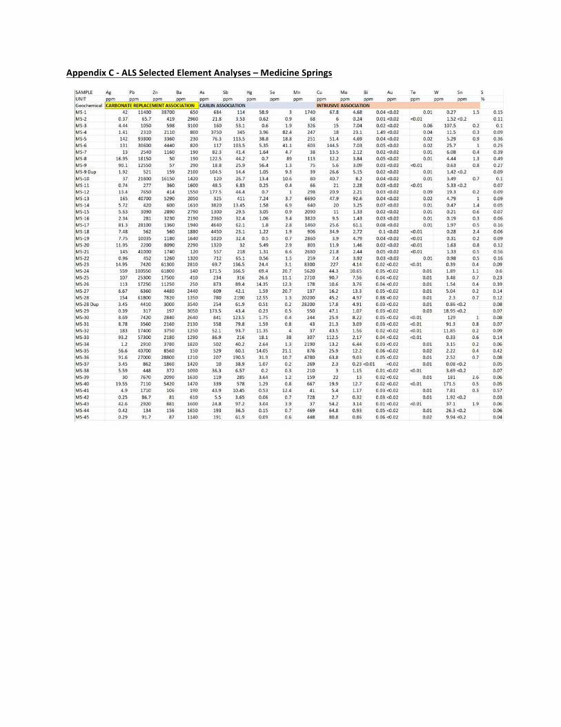
AppendixC-ALSSelectedElementAnalyses–MedicineSprings
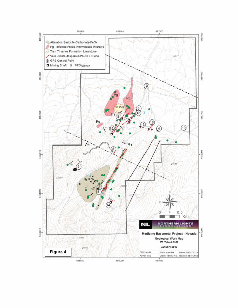
Figure 4
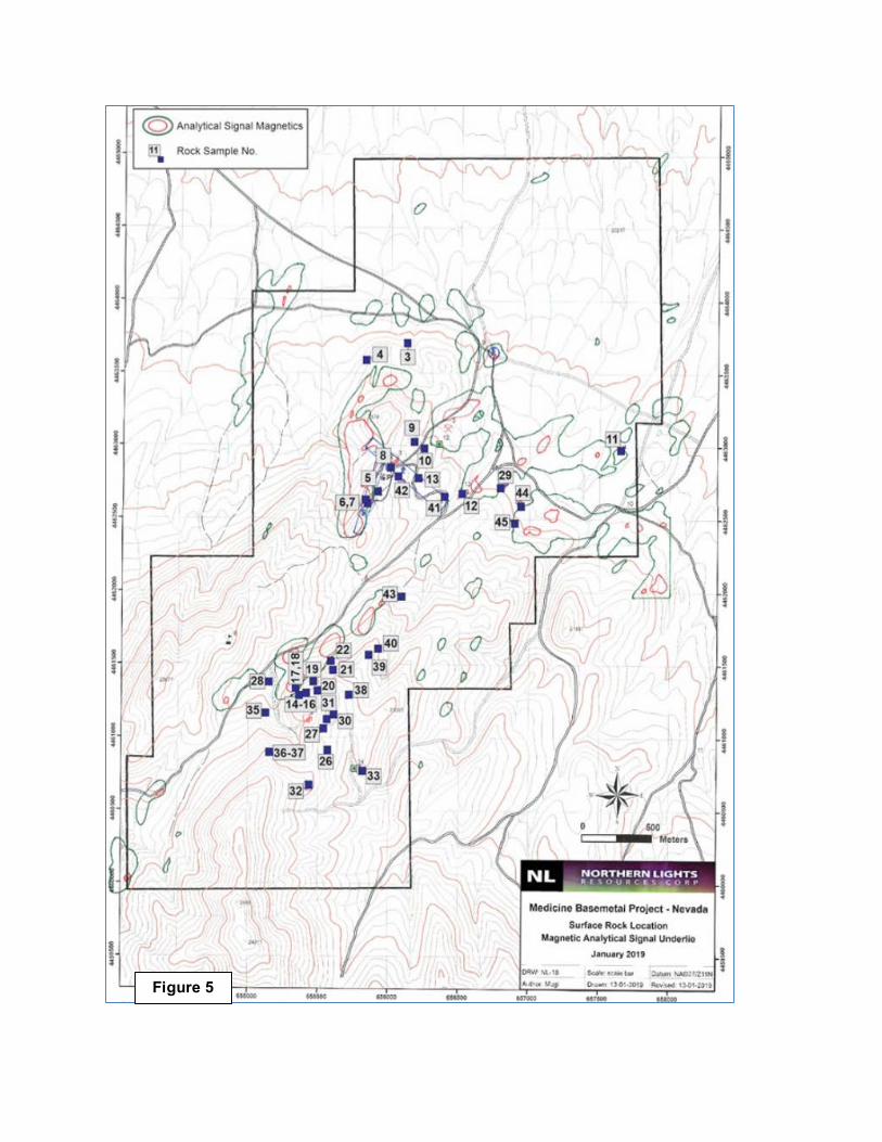
Figure 5