Embed Size (px)
Citation preview
Measurements of Groundwater Seepage Flux Onto a Coral Reef: Spatial and TemporalVariationsAuthor(s): John B. LewisSource: Limnology and Oceanography, Vol. 32, No. 5 (Sep., 1987), pp. 1165-1169Published by: American Society of Limnology and OceanographyStable URL: http://www.jstor.org/stable/2836793 .
Accessed: 13/06/2014 09:21
Your use of the JSTOR archive indicates your acceptance of the Terms & Conditions of Use, available at .http://www.jstor.org/page/info/about/policies/terms.jsp
.JSTOR is a not-for-profit service that helps scholars, researchers, and students discover, use, and build upon a wide range ofcontent in a trusted digital archive. We use information technology and tools to increase productivity and facilitate new formsof scholarship. For more information about JSTOR, please contact [email protected].
.
American Society of Limnology and Oceanography is collaborating with JSTOR to digitize, preserve andextend access to Limnology and Oceanography.
http://www.jstor.org
This content downloaded from 91.229.248.187 on Fri, 13 Jun 2014 09:21:14 AMAll use subject to JSTOR Terms and Conditions
Notes 1165
Limnol. Oceanogr., 32(5), 1987, 1165-1169 ? 1987, by the Amencan Society of Limnology and Oceanography, Inc.
Measurements of groundwater seepage flux onto a coral reef: Spatial and temporal variations
Abstract-Rates of groundwater discharge onto coral reefs at Barbados, West Indies, were mea- sured with seepage meters and miniature piezom- eters. Seepage flux varied spatially, was correlated with water depth, and was about twice as high during the wet season as during the dry. Ground- water nitrogen concentrations were correlated with salinity but phosphate concentrations were not. Nitrate content of the discharge was much higher than was phosphate content. Measured fluxes were consistent with groundwater discharge estimates from aquifer models, but a large data set would be required to make accurate predictions of areal groundwater discharge and nutrient loading.
Much of the research dealing with groundwater flux at the benthic boundary layer has been concerned with lakes (Brock et al. 1982; Frape and Patterson 1981; Lee and Hynes 1978; Lee et al. 1980) and es- tuaries (Bokuniewicz 1980; Lee 1977; Vali- ela et al. 1978; Zimmermann et al. 1985). Johannes (1980) has drawn attention to the subject of discharge of groundwater into the sea and its potential significance in coastal production and eutrophication. Some at- tention has been given to the study of groundwater flux onto coral reefs (D'Elia et al. 1981; Lewis 1985; Marsh 1977) and the subject of groundwater movement within tropical atoll aquifers has been reviewed (Oberdorfer and Buddemeier 1985).
Except for the dye tracer studies of Pamell (1986) and Oberdorfer and Buddemeier (1986), there are no actual field measure- ments of groundwater flux onto coral reefs and most estimates of groundwater dis- charge are calculated from aquifer models (Buddemeier 1981; Buddemeier and Hol- laday 1977; Herman and Wheatcraft 1984). My purpose here is to report the first direct in situ measurements of groundwater flux onto a coral reef, with emphasis on temporal and spatial variations in flow and on ground- water seepage as a source of nutrient input. I then compare measurements with pre- vious calculations of discharge from groundwater models in Barbados. Ground-
water flux along oceanic island coasts is probably implicated in the "island mass ef- fect"-the term introduced by Doty and Oguri (1956) to explain the shoreward in- crease in phytoplankton productivity. This modification of production occurs in Bar- bados and is considered by Sander (1981) to be a result of eutrophication of coastal waters due to terrestrial runoff and coastal circulation. Dandonneau and Charpy (1985) have argued that the "island mass effect" does not explain the high chlorophyll con- centrations in all island coastal waters.
Wastewater discharges onto the west coast of Barbados include sewage effluent, groundwater discharge, and industrial wastes as important sources of pollution. Although there is a central sewage treatement plant at Bridgetown, sewage from the densely pop- ulated west coast is dumped on the land through dry toilets, suckwell systems, and septic tanks and from these leaks into the groundwater. Groundwater nutrient enrich- ment also occurs through the addition of fertilizers (Proctor and Redfern Int. Ltd. 1983). Industrial wastes are localized in the Bridgetown area on the southwest coast, but may be carried northward along the coast by nearshore currents (Peck 1978). Thus the most important sources of nutrient addition to the groundwater appear to be from ag- riculture and urban development. The high permeability and transmissivity of the Bar- bados aquifer (Harris 1971) lead one to ex- pect significant discharges of groundwater and substantial nutrient loading along the west coast.
Groundwater flux from the benthic boundary layer was measured with the methods of Lee (1977) and Lee and Cherry (1978). Miniature piezometers and seepage meters were implanted in sandy bottoms within a few meters of shore at sites adjacent to fringing reefs (Lewis 1960) along the west coast of Barbados. The seepage meters were smaller (0.042 m2) than the instrument de- scribed by Lee (1977), but the procedures
This content downloaded from 91.229.248.187 on Fri, 13 Jun 2014 09:21:14 AMAll use subject to JSTOR Terms and Conditions
1166 Notes
0 15
0.
0 005 .-j
z .\
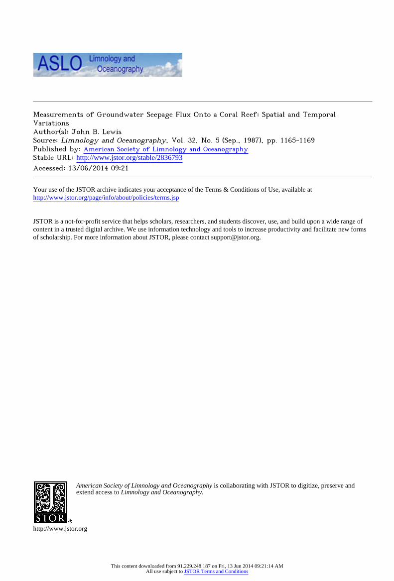
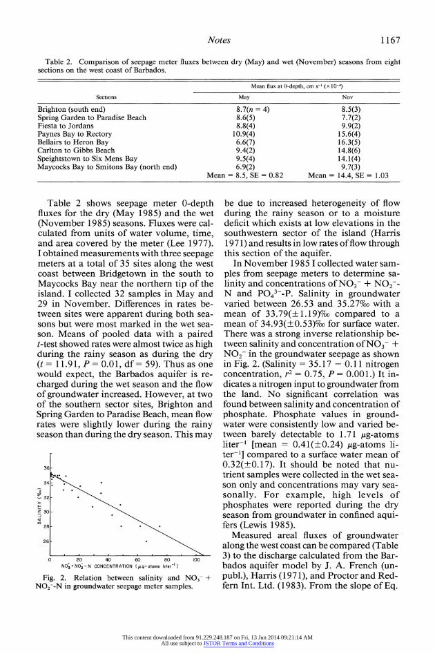
0 25 50 75 100 125 150 WATER DEPTH (cm)
Fig. 1. Relation between groundwater seepage rate and water depth determined from piezometer mea- surements.
for collecting water were the same. Zim- mermann et al. (1985) also used a small seepage meter of 0.06 M2. After measuring water depth and collecting water samples, I measured the volume and transferred the samples to 300-ml bottles for subsequent salinity and nutrient determinations. Salin- ity was determined by conductivity and NO3- + NO2--N and P043--P by the meth- ods of Strickland and Parsons (1965).
Surface water samples were collected con- currently from the immediate vicinity of the groundwater samplers. Nutrient water sam- ples were kept cool in an insulated box and frozen within 2 h of collection. The length of time required to fill the groundwater sam- ple bags varied between 30 min and 1 h. Because of the brief residence time of the water in the seepage meter bags, it is un- likely that it was modified relative to the sediment seepage water. To collect samples for water analysis, I implanted the seepage meters fully into the sand so that the bottom of the meter was flush with the sediment. This forced all the water overlying the sed- iments out of the meter. As an additional precaution, I vented the meters for 15 min before fixing the bags to ensure that the water in the headspace was replaced completely by flowing groundwater.
Tidal height or water depth will alter the hydraulic gradient of an aquifer and ground- water flow would be expected to be reduced at high tide and increased at low tide. The relationship between groundwater seepage and water depth was determined by record- ing hourly measurements of flow rates over
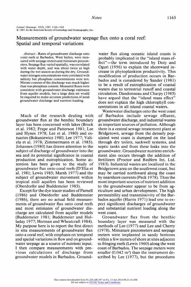
Table 1. Variability of water-depth-corrected groundwater seepage (cm3 s-') from six piezometers at nine successive times at a single site. Each row rep- resents a different time interval of about 30-min du- ration.
1 2 3 4 5 6
0.12 0.13 0.20 0.10 0.14 0.11 0.12 0.19 0.12 0.09 0.15 0.11 0.13 0.17 0.16 0.10 0.14 0.11 0.13 0.16 0.14 0.10 0.14 0.11 0.30 0.12 0.13 0.13 0.14 0.12 0.22 0.08 0.13 0.14 0.15 0.12 0.14 0.15 0.15 0.16 0.16 0.11 0.16 0.14 0.14 0.14 0.13 0.11 0.14 0.14 0.15 0.11 0.08 0.08
Two-way ANOVA
Source of variation SS df F-ratio
Among piezometers 0.01 5 0.75 Time 0.08 8 3.41 Error 0.11 40 Fo 0, (5/40) = 9 29, Fo 0, (8/40) = 5. 1 1.
a complete tidal cycle in May from a cluster of three piezometers placed within 1 m of each other. From measured volumes and concurrent water heights, a regression line was obtained (Fig. 1). As expected, there was a negative relationship between seepage flow and water depth. The best fit from the pooled data was obtained with a linear regression:
seepage rate (cm3 s-) = 0.1203 - 0.0008 water depth (cm) (1)
r2 = 0.46, P = 0.01. Because of the heterogeneity of ground-
water flow rates (Lee and Hynes 1978; Zim- mermann et al. 1985), it was important to ascertain the variability of the flux at a single site. I set up six piezometers within 1 m of each other and obtained repeated measure- ments over half of a tidal cycle in May (Ta- ble 1). Seepage velocities (as described by Lee 1977) at zero depths (y-intercepts) were calculated, assuming the slope of Eq. 1. From a two-way ANOVA (Table 1) I de- termined that there were no significant dif- ferences at the 1 % level in flow rates be- tween individual piezometers nor any significant differences between the contin- uous measurements from a single piezom- eter. Thus heterogeneity of flux at a single site was. not significant over the time period sampled.
This content downloaded from 91.229.248.187 on Fri, 13 Jun 2014 09:21:14 AMAll use subject to JSTOR Terms and Conditions
Notes 1167
Table 2. Comparison of seepage meter fluxes between dry (May) and wet (November) seasons from eighl sections on the west coast of Barbados.
Mean flux at 0-depth, cm s-' (x 10-4)
Sections May Nov
Brighton (south end) 8.7(n = 4) 8.5(3) Spring Garden to Paradise Beach 8.6(5) 7.7(2) Fiesta to Jordans 8.8(4) 9.9(2) Paynes Bay to Rectory 10.9(4) 15.6(4) Bellairs to Heron Bay 6.6(7) 16.3(5) Carlton to Gibbs Beach 9.4(2) 14.8(6) Speightstown to Six Mens Bay 9.5(4) 14.1(4) Maycocks Bay to Smitons Bay (north end) 6.9(2) 9.7(3)
Mean = 8.5, SE = 0.82 Mean = 14.4, SE = 1.03
Table 2 shows seepage meter 0-depth fluxes for the dry (May 1985) and the wet (November 1985) seasons. Fluxes were cal- culated from units of water volume, time, and area covered by the meter (Lee 1977). I obtained measurements with three seepage meters at a total of 35 sites along the west coast between Bridgetown in the south to Maycocks Bay near the northern tip of the island. I collected 32 samples in May and 29 in November. Differences in rates be- tween sites were apparent during both sea- sons but were most marked in the wet sea- son. Means of pooled data with a paired t-test showed rates were almost twice as high during the rainy season as during the dry (t = 11.91, P = 0.01, df= 59). Thus as one would expect, the Barbados aquifer is re- charged during the wet season and the flow of groundwater increased. However, at two of the southern sector sites, Brighton and Spring Garden to Paradise Beach, mean flow rates were slightly lower during the rainy season than during the dry season. This may
36
34.
-32 .
z30 .
28 -
26-
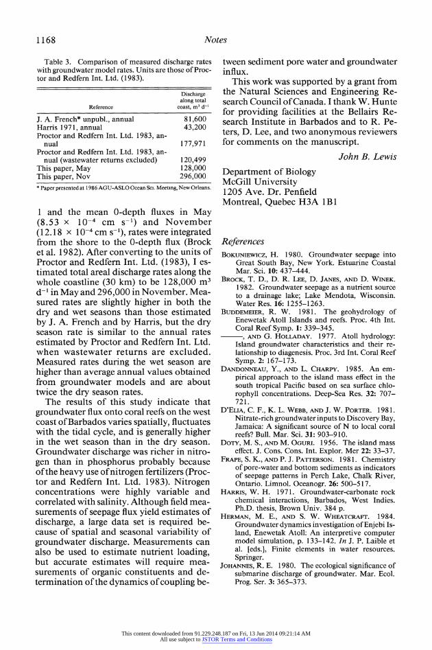
0 20 40 60 80 100 N03+ N02 - N CONCENTRATION (pg- atoms literK)
Fig. 2. Relation between salinity and N03- + N02--N in groundwater seepage meter samples.
be due to increased heterogeneity of flow during the rainy season or to a moisture deficit which exists at low elevations in the southwestern sector of the island (Harris 1971) and results in low rates of flow through this section of the aquifer.
In November 1985 I collected water sam- ples from seepage meters to determine sa- linity and concentrations of NO3- + NO2-- N and P043--P. Salinity in groundwater varied between 26.53 and 35.27%oo with a mean of 33.79(?1.19)%oo compared to a mean of 34.93(?0.53)%oo for surface water. There was a strong inverse relationship be- tween salinity and concentration of NO3- + N02- in the groundwater seepage as shown in Fig. 2. (Salinity = 35.17 - 0.11 nitrogen concentration, r2 = 0.75, P = 0.001.) It in- dicates a nitrogen input to groundwater from the land. No significant correlation was found between salinity and concentration of phosphate. Phosphate values in ground- water were consistently low and varied be- tween barely detectable to 1.71 ,ug-atoms liter-' [mean = 0.41(?0.24) ,ug-atoms li- ter-'] compared to a surface water mean of 0.32(?0.17). It should be noted that nu- trient samples were collected in the wet sea- son only and concentrations may vary sea- sonally. For example, high levels of phosphates were reported during the dry season from groundwater in confined aqui- fers (Lewis 1985).
Measured areal fluxes of groundwater along the west coast can be compared (Table 3) to the discharge calculated from the Bar- bados aquifer model by J. A. French (un- publ.), Harris (1971), and Proctor and Red- fern Int. Ltd. (1983). From the slope of Eq.
This content downloaded from 91.229.248.187 on Fri, 13 Jun 2014 09:21:14 AMAll use subject to JSTOR Terms and Conditions
1168 Notes
Table 3. Comparison of measured discharge rates with groundwater model rates. Units are those of Proc- tor and Redfem Int. Ltd. (1983).
Discharge along total
Reference coast, m3 d-'
J. A. French* unpubl., annual 81,600 Harris 1971, annual 43,200 Proctor and Redfern Int. Ltd. 1983, an-
nual 177,971 Proctor and Redfern Int. Ltd. 1983, an-
nual (wastewater returns excluded) 120,499 This paper, May 128,000 This paper, Nov 296,000 * Paper presented at 1986 AGU-ASLO Ocean Scl. Meeting, New Orleans.
1 and the mean 0-depth fluxes in May (8.53 x 10⁻⁴ cm s- 1) and November (12.18 x 10⁻⁴ cm s-'), rates were integrated from the shore to the 0-depth flux (Brock et al. 1982). After converting to the units of Proctor and Redfem Int. Ltd. (1983), I es- timated total areal discharge rates along the whole coastline (30 km) to be 128,000 m3 d-l in May and 296,000 in November. Mea- sured rates are slightly higher in both the dry and wet seasons than those estimated by J. A. French and by Harris, but the dry season rate is similar to the annual rates estimated by Proctor and Redfem Int. Ltd. when wastewater returns are excluded. Measured rates during the wet season are higher than average annual values obtained from groundwater models and are about twice the dry season rates.
The results of this study indicate that groundwater flux onto coral reefs on the west coast of Barbados varies spatially, fluctuates with the tidal cycle, and is generally higher in the wet season than in the dry season. Groundwater discharge was richer in nitro- gen than in phosphorus probably because of the heavy use of nitrogen fertilizers (Proc- tor and Redfern Int. Ltd. 1983). Nitrogen concentrations were highly variable and correlated with salinity. Although field mea- surements of seepage flux yield estimates of discharge, a large data set is required be- cause of spatial and seasonal variability of groundwater discharge. Measurements can also be used to estimate nutrient loading, but accurate estimates will require mea- surements of organic constituents and de- termination of the dynamics of coupling be-
tween sediment pore water and groundwater influx.
This work was supported by a grant from the Natural Sciences and Engineering Re- search Council of Canada. I thank W. Hunte for providing facilities at the Bellairs Re- search Institute in Barbados and to R. Pe- ters, D. Lee, and two anonymous reviewers for comments on the manuscript.
John B. Lewis
Department of Biology McGill University 1205 Ave. Dr. Penfield Montreal, Quebec H3A 1 B 1
References BOKUNIEWICZ, H. 1980. Groundwater seepage into
Great South Bay, New York. Estuarine Coastal Mar. Sci. 10: 437-444.
BROCK, T. D., D. R. LEE, D. JANES, AND D. WINEK. 1982. Groundwater seepage as a nutrient source to a drainage lake; Lake Mendota, Wisconsin. Water Res. 16: 1255-1263.
BUDDEMEIER, R. W. 1981. The geohydrology of Enewetak Atoll Islands and reefs. Proc. 4th Int. Coral Reef Symp. 1: 339-345.
, AND G. HOLLADAY. 1977. Atoll hydrology: Island groundwater characteristics and their re- lationship to diagenesis. Proc. 3rd Int. Coral Reef Symp. 2: 167-173.
DANDONNEAU, Y., AND L. CHARPY. 1985. An em- pirical approach to the island mass effect in the south tropical Pacific based on sea surface chlo- rophyll concentrations. Deep-Sea Res. 32: 707- 721.
D'ELIA, C. F., K. L. WEBB, AND J. W. PORTER. 1981. Nitrate-rich groundwater inputs to Discovery Bay, Jamaica: A significant source of N to local coral reefs? Bull. Mar. Sci. 31: 903-910.
DOTY, M. S., AND M. OGURI. 1956. The island mass effect. J. Cons. Cons. Int. Explor. Mer 22: 33-37.
FRAPE, S. K., AND P. J. PATTERSON. 1981. Chemistry of pore-water and bottom sediments as indicators of seepage patterns in Perch Lake, Chalk River, Ontario. Limnol. Oceanogr. 26: 500-517.
HARRIS, W. H. 1971. Groundwater-carbonate rock chemical interactions, Barbados, West Indies. Ph.D. thesis, Brown Univ. 384 p.
HERMAN, M. E., AND S. W. WHEATCRAFT. 1984. Groundwater dynamics investigation of Enjebi Is- land, Enewetak Atoll: An interpretive computer model simulation, p. 133-142. In J. P. Laible et al. [eds.], Finite elements in water resources. Springer.
JOHANNES, R. E. 1980. The ecological significance of submarine discharge of groundwater. Mar. Ecol. Prog. Ser. 3: 365-373.
This content downloaded from 91.229.248.187 on Fri, 13 Jun 2014 09:21:14 AMAll use subject to JSTOR Terms and Conditions
Notes 1169
LEE, D. R. 1977. A device for measuring seepage flux of lakes and estuaries. Limnol. Oceanogr. 22: 140- 147.
, AND J. A. CHERRY. 1978. A field exercise on groundwater flow using seepage meters and mini- piezometers. J. Geol. Educ. 27: 6-10.
, AND J. F. PICKENS. 1980. Ground- water transport of a salt tracer through a sandy lakebed. Limnol. Oceanogr. 25: 45-61.
, AND H. B. N. HYNES. 1978. Identification of groundwater discharge zones in a reach of Hillman Creek in southern Ontario. Water Pollut. Res. Can. 13: 121-133.
LEWIS, J. B. 1960. The coral reefs and coral com- munities of Barbados, West Indies. Can. J. Zool. 38: 1133-1145.
1985. Groundwater discharge onto coral reefs. Barbados, West Indies. Proc. 5th Int. Coral Reef Symp. 6: 477-48 1.
MARSH, J. A. 1977. Terrestrial inputs of nitrogen and phosphorus of fringing reefs of Guam. Proc. 3rd Int. Coral Reef Symp. 1: 331-336.
OBERDORFER, J. A., AND R. W. BUDDEMEIER. 1985. Coral reef hydrology. Proc. 5th Int. Coral Reef Symp. 3: 307-312.
, AND . 1986. Coral reef hydrology: Field studies of water movement within a barrier reef. Coral Reefs 5: 7-12.
PARNELL, K. E. 1986. Water movement within a fringing reef flat, Orpheus Island, North Queens- land, Australia. Coral Reefs 5: 1-6.
PECK, S. G. 1978. A physical oceanographic study off the southwestern coast of Barbados. M.S. thesis, McGill Univ. 99 p.
PROCTOR AND REDFERN INTERNATIONAL LTD. 1983. Coastal conservation project, V. 2; sect. 8: Drain- age and groundwater models. 50 p.
SANDER, L. 1981. A preliminary assessment of the main causative mechanisms of the "island mass effect" of Barbados. Mar. Biol. 46: 199-205.
STRICKLAND, J. D. H., AND T. R. PARSONS. 1965. A practical handbook of seawater analysis. Bull. Fish. Res. Bd. Can. 125.
VALIELA, I., J. M TEAL, S. VOLKMANN, D. SHAFER, AND E. J. CARPENTER. 1978. Nutrient and particulate fluxes in a salt marsh ecosystem: Tidal exchanges and inputs by precipitation and groundwater. Limnol. Oceanogr. 23: 798-812.
ZIMMERMANN, C. F., J. R. MONTGOMERY, AND P. R. CARLSON. 1985. Variability of dissolved reactive phosphate flux rates in nearshore estuarine sedi- ments: Effects of groundwater flow. Estuaries 8: 228-236.
Submitted: 3 July 1986 Accepted: 24 November 1986
Limnol. Oceanogr., 32(5), 1987, 1169-1176 C) 1987, by the Amencan Society of Limnology and Oceanography, Inc.
Seasonal and longitudinal variations in apparent deposition rates within an Arkansas reservoir 1
Abstract-Seasonal and spatial differences in apparent sediment trapping rates were related to the establishment of longitudinal gradients in water quality at DeGray Lake, Arkansas. Gra- dients in turbidity developed during winter and spring due to high suspended loads, which settled primarily in the headwater region. Gradients in apparent deposition of allochthonous organic carbon and chlorophyll a also influenced detrital processing and hypolimnetic dissolved oxygen conditions. Hypolimnetic dissolved oxygen de- pletion started in May in the headwater region, due to a high volumetric dissolved oxygen de- mand, and spread slowly to the dam by winter. These patterns indicated that riverine inputs and deposition influenced biological activity along the longitudinal axis of the lake.
l This research was performed as a part of the En- vironmental and Water Quality Operational Studies of the U.S. Army Corps of Engineers. Permission was granted by the Chief of Engineers to publish this in- formation.
Reservoirs are dominated by river inputs, advective flow regimes, and regulated out- flows (Carmack et al. 1979). These hydro- dynamic characteristics, and the transport and sedimentation of influent materials, provide a physical setting that fosters the establishment of physical, chemical, and bi- ological gradients from headwaters to dam (Baxter 1977; Gloss et al. 1980; Kennedy et al. 1982; Thornton et al. 1982). Although such water quality gradients have been doc- umented in reservoirs, there is little infor- mation regarding similar patterns in sedi- mentation rates (Hakanson 1976; Pharo and Carmack 1979). We examined the influence of river loading on seasonal, longitudinal, and vertical patterns in apparent sedimen- tation rates at DeGray Lake, Arkansas. Re- search was directed toward the hypotheses that longitudinal gradients in sedimentation
This content downloaded from 91.229.248.187 on Fri, 13 Jun 2014 09:21:14 AMAll use subject to JSTOR Terms and Conditions