Embed Size (px)
Citation preview
MDRRM-CCA PLAN 2013-2016
Municipality of
JAGNA
MDRRMC
DRRM/CCA Plan of the Municipality of JAGNA Page 1
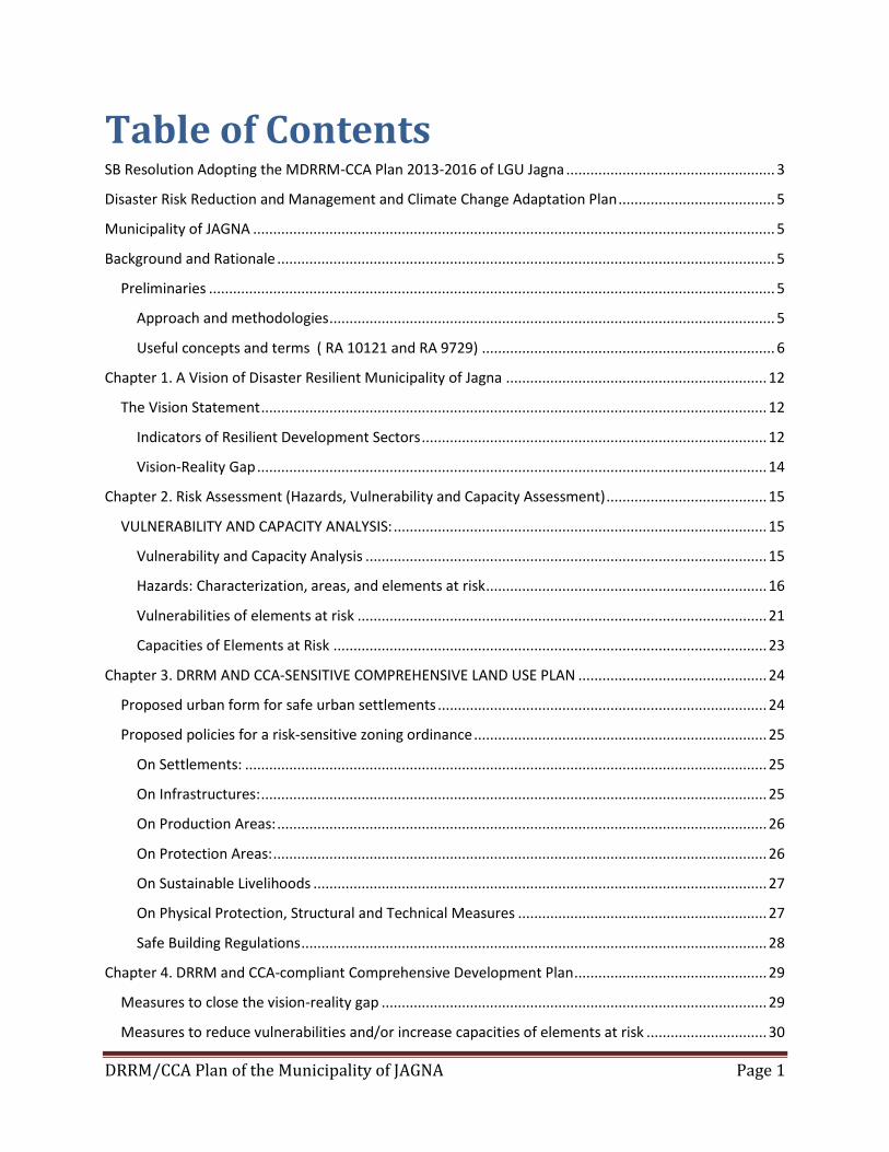
Table of Contents SB Resolution Adopting the MDRRM-CCA Plan 2013-2016 of LGU Jagna .................................................... 3
Disaster Risk Reduction and Management and Climate Change Adaptation Plan ....................................... 5
Municipality of JAGNA .................................................................................................................................. 5
Background and Rationale ............................................................................................................................ 5
Preliminaries ............................................................................................................................................. 5
Approach and methodologies ............................................................................................................... 5
Useful concepts and terms ( RA 10121 and RA 9729) ......................................................................... 6
Chapter 1. A Vision of Disaster Resilient Municipality of Jagna ................................................................. 12
The Vision Statement .............................................................................................................................. 12
Indicators of Resilient Development Sectors ...................................................................................... 12
Vision-Reality Gap ............................................................................................................................... 14
Chapter 2. Risk Assessment (Hazards, Vulnerability and Capacity Assessment) ........................................ 15
VULNERABILITY AND CAPACITY ANALYSIS: ............................................................................................. 15
Vulnerability and Capacity Analysis .................................................................................................... 15
Hazards: Characterization, areas, and elements at risk ...................................................................... 16
Vulnerabilities of elements at risk ...................................................................................................... 21
Capacities of Elements at Risk ............................................................................................................ 23
Chapter 3. DRRM AND CCA-SENSITIVE COMPREHENSIVE LAND USE PLAN ............................................... 24
Proposed urban form for safe urban settlements .................................................................................. 24
Proposed policies for a risk-sensitive zoning ordinance ......................................................................... 25
On Settlements: .................................................................................................................................. 25
On Infrastructures: .............................................................................................................................. 25
On Production Areas: .......................................................................................................................... 26
On Protection Areas: ........................................................................................................................... 26
On Sustainable Livelihoods ................................................................................................................. 27
On Physical Protection, Structural and Technical Measures .............................................................. 27
Safe Building Regulations .................................................................................................................... 28
Chapter 4. DRRM and CCA-compliant Comprehensive Development Plan ................................................ 29
Measures to close the vision-reality gap ................................................................................................ 29
Measures to reduce vulnerabilities and/or increase capacities of elements at risk .............................. 30
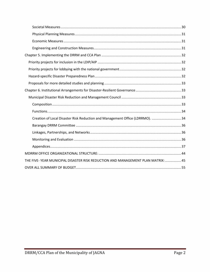
DRRM/CCA Plan of the Municipality of JAGNA Page 2
Societal Measures ............................................................................................................................... 30
Physical Planning Measures ................................................................................................................ 31
Economic Measures ............................................................................................................................ 31
Engineering and Construction Measures ............................................................................................ 31
Chapter 5. Implementing the DRRM and CCA Plan .................................................................................... 32
Priority projects for inclusion in the LDIP/AIP ........................................................................................ 32
Priority projects for lobbying with the national government ................................................................. 32
Hazard-specific Disaster Preparedness Plan ........................................................................................... 32
Proposals for more detailed studies and planning ................................................................................. 33
Chapter 6. Institutional Arrangements for Disaster-Resilient Governance ................................................ 33
Municipal Disaster Risk Reduction and Management Council ............................................................... 33
Composition ........................................................................................................................................ 33
Functions. ............................................................................................................................................ 34
Creation of Local Disaster Risk Reduction and Management Office (LDRRMO). ............................... 34
Barangay DRRM Committee ............................................................................................................... 36
Linkages, Partnerships, and Networks ................................................................................................ 36
Monitoring and Evaluation ................................................................................................................. 36
Appendices .......................................................................................................................................... 37
MDRRM OFFICE ORGANIZATIONAL STRUCTURE: ....................................................................................... 44
THE FIVE- YEAR MUNICIPAL DISASTER RISK REDUCTION AND MANAGEMENT PLAN MATRIX: ................. 45
OVER ALL SUMMARY OF BUDGET............................................................................................................... 55
DRRM/CCA Plan of the Municipality of JAGNA Page 3
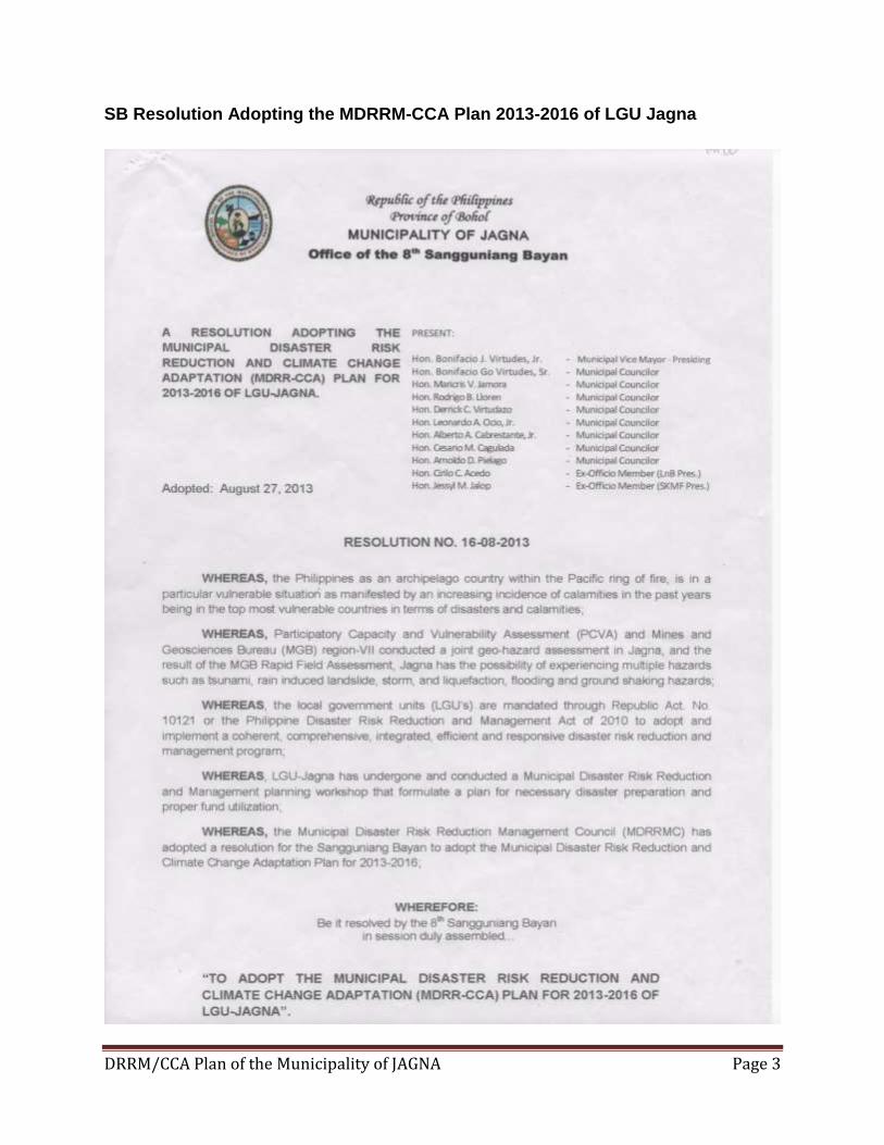
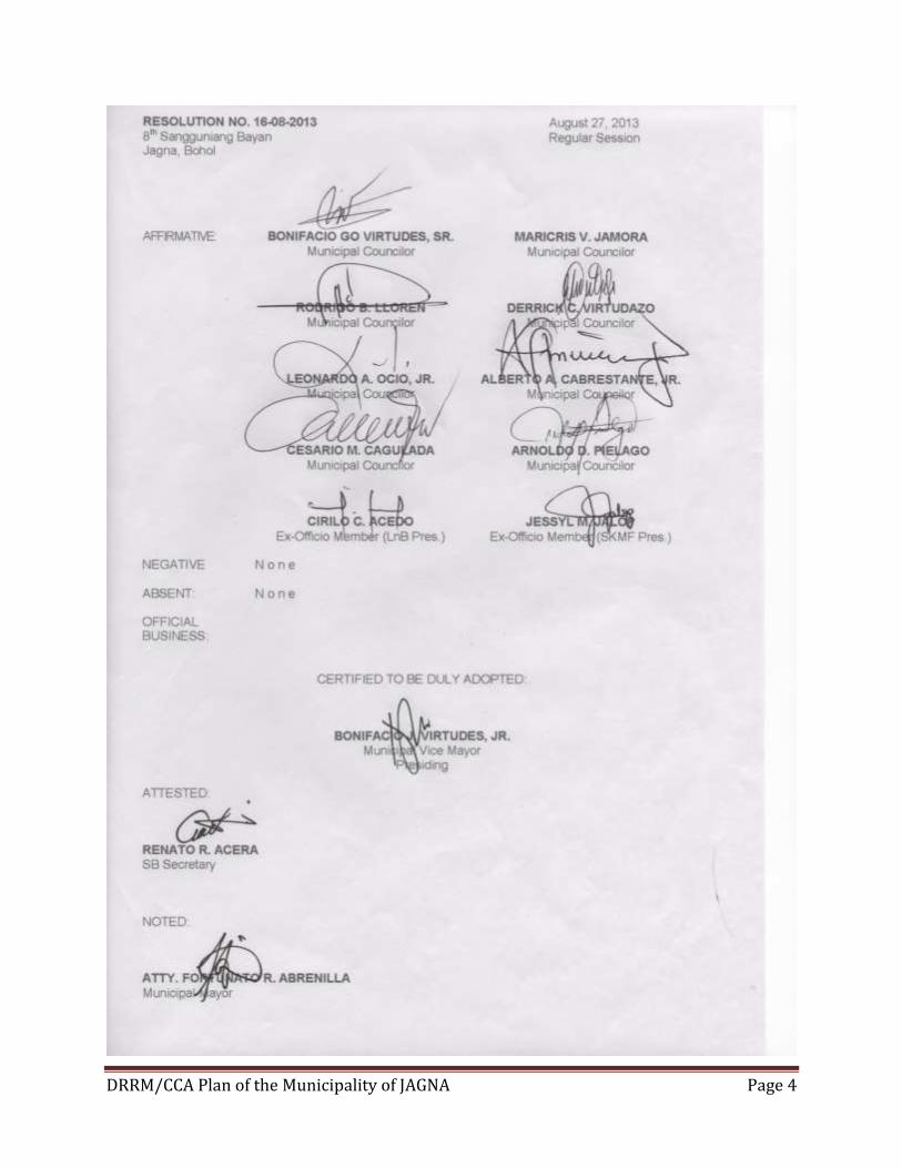
SB Resolution Adopting the MDRRM-CCA Plan 2013-2016 of LGU Jagna
DRRM/CCA Plan of the Municipality of JAGNA Page 4
DRRM/CCA Plan of the Municipality of JAGNA Page 5
Disaster Risk Reduction and Management and Climate Change Adaptation Plan Municipality of JAGNA
Background and Rationale Preliminaries
Recognizing the high disaster risk of the municipality of Jagna, the members of the Municipal Disaster Risk Reduction Management Council (MDRRMC) have initiated the development of a Disaster Risk Reduction Management Plan and Climate Change Adaptation (DRRM-CCA) Plan to guide the integration of a risk reduction agenda into on-going governance and ensuring sustainable development and poverty reduction in aligning the vision of the municipality to become a progressive center of development and economic services in South eastern Bohol. Jagna has a total population of 32,034 is considered as one of the environmentally constrained areas prone to natural hazards like flooding, earthquake, rain-induced landslide, tsunami and liquefaction based on the rapid and community assessment conducted by PHIVOLCs and OCD under the READY project in February 2007, the municipality of Jagna is susceptible to some disaster and hazard risks. Among them are rain-induced landslide, storm surges, tsunami, liquefaction, flooding and ground shaking hazards. This assessment maybe one of the reason that LGU Jagna is one of the chosen pilot area in mainstreaming disaster risk reduction management and climate change adaptation nationwide. Mines and Geosciences Bureau – Region VII also conducted a field geo-hazard assessment of landslide and flood prone barangays in Jagna and the result of the MGB Rapid Field Assessment is as follows: 1. There are five (5) barangays with high landslide susceptibility (Barangays Mayana, Malbog,
Calabacita, Tubod Monte and Boctol). 2. There are seven (7) barangays with moderate landslide susceptibility (Barangays Balili, Buyog,
Cantuyoc, Odiong, Alejawan, Canjulao and Kinagbaan). 3. There are twenty-one (21) barangays with low landslide susceptibility (Barangays Bunga Mar,
Lonoy, Cambugason, Can-ipol , Cabungaan, Laca, Bunga Ilaya, Naatang, Tubod Mar, Larapan, nausok, Pangdan, Tejero, Poblacion, Looc, Pagina, Can-upao, Cantagay, Ipil, Faraon and Can-uba).
4. There are nine (9) barangays that are susceptible to flooding (Barangays Bunga Mar, Poblacion, Tejero, Looc, Pangdan, Kinagbaan, Cambugason, Lonoy and Alejawan).
Approach and methodologies
The old approach to disaster management was characterized by a focus on giving assistance or intervention during or immediately after disaster. There was heavy reliance on physical and engineering solutions directed at predicting, modelling and modifying natural hazards. Under the new approach there is as much attention given to hazards as to vulnerabilities and capacities
DRRM/CCA Plan of the Municipality of JAGNA Page 6
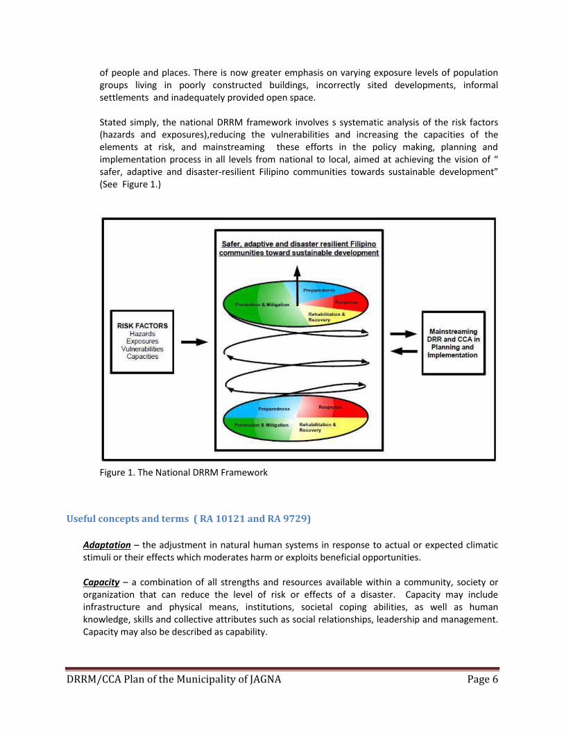
of people and places. There is now greater emphasis on varying exposure levels of population groups living in poorly constructed buildings, incorrectly sited developments, informal settlements and inadequately provided open space. Stated simply, the national DRRM framework involves s systematic analysis of the risk factors (hazards and exposures),reducing the vulnerabilities and increasing the capacities of the elements at risk, and mainstreaming these efforts in the policy making, planning and implementation process in all levels from national to local, aimed at achieving the vision of “ safer, adaptive and disaster-resilient Filipino communities towards sustainable development” (See Figure 1.)
Figure 1. The National DRRM Framework
Useful concepts and terms ( RA 10121 and RA 9729)
Adaptation – the adjustment in natural human systems in response to actual or expected climatic stimuli or their effects which moderates harm or exploits beneficial opportunities. Capacity – a combination of all strengths and resources available within a community, society or organization that can reduce the level of risk or effects of a disaster. Capacity may include infrastructure and physical means, institutions, societal coping abilities, as well as human knowledge, skills and collective attributes such as social relationships, leadership and management. Capacity may also be described as capability.
DRRM/CCA Plan of the Municipality of JAGNA Page 7
Civil Defense – disaster preparedness and prevention activities, other than military actions, geared towards the reduction of loss of life and property brought about by natural and human-induced disasters. Civil Defense may also be referred to as Civil Protection. Civil Society Organizations (CSOs) - non-state actors whose aims are neither to generate profits nor to seek governing power, CSO’s unite people to advance shared goals and interests. They have a presence in public life, expressing the interests and values of their members or others, and are based on ethical, cultural, scientific, religious or philanthropic considerations. CSO’s include non-government organizations NGO’s), professional associations, foundations, independent research institutes, community-based organizations (CBO’s), faith-based organizations, people’s organizations, social movements, and labor unions. Climate Change – a change in climate that can be identified by changes in the mean and/or variability of its properties and that persists for an extended period typically decades or longer, whether due to natural variability or as a result of human activity. Community-Based Disaster Risk Reduction and Management (CDRRM) - a process of disaster risk reduction and management in which at risk communities are actively engaged in the identification, analysis, treatment, monitoring and evaluation of disaster risks in order to reduce their vulnerabilities and enhance their capabilities, and where the people are at the heart of decision-making and implementation of disaster risk reductions and management activities. Complex Emergency - a form of human-induced emergency in which the cause of the emergency as well as the assistance to the afflicted is complicated by intense level of political considerations. Contingency Planning - a management process that analyzes specific potential events or emerging situations that might threaten society or the environment and establishes arrangements in advance to enable timely, effective and appropriate responses to such events and situations. Disaster - a serious disruption of the functioning of a community or a society involving widespread human, material, economic or environmental losses and impacts, which exceeds the ability of the affected community or society to cope using its own resources. Disasters are often described as a result of the combination of the exposure to a hazard; the condition of vulnerability that are present; and insufficient capacity or measures to reduce or cope with the potential negative consequences. Disaster impacts may include loss of life, injury, disease and other negative effects on human, physical and social well-being, together with damage to property, destruction of assets, loss of services, social and economic disruption and environmental degradation. Disaster Mitigation - the lessening or limitation of the adverse impacts of hazards and related disasters. Mitigation measures encompass engineering techniques and hazard-resistant construction as well as improved environmental policies and public awareness. Disaster Preparedness - the knowledge and capacities developed by governments, professional response and recovery organizations, communities and individuals to effectively anticipate, respond to and recover from, the impacts of likely, imminent or current hazard events or conditions. Preparedness action is carried out within the content of disaster risk reduction and management and aims to build the capacities needed to efficiently manage all types of emergencies and achieve orderly transitions from response to sustained recovery. Preparedness is based in a sound analysis
DRRM/CCA Plan of the Municipality of JAGNA Page 8
of disaster risk and gook linkages with early warning systems, and includes such activities as contingency planning, stockpiling of equipment and supplies, the development of arrangements for coordination, evacuation and public information, and associated training and field exercises. These must be supported by formal institutional, legal and budgetary capacities. Disaster Prevention – the outright avoidance of adverse impacts of hazards and related disasters. It expresses the concept and intention to complexly avoid potential adverse impact through action taken in advance such as construction of dams or embankments that eliminate flood risks, land-use regulations that do not permit any settlement in high-risk zones, and seismic engineering designs that ensure the survival and function of a critical building in any likely earthquake. Disaster Response - the provision of emergency services and public assistance during or immediately after a disaster in order to save lives reduces health impacts, ensure public safety and meet the subsistence needs of the people affected. Disaster response is predominantly focused on immediate and short-term needs and is sometimes called “disaster relief”. Disaster Risk - the potential disaster losses in lives, health status, livelihood, assets and services, which could occur to a particular community or a society over some specified future time period. Disaster Risk Reduction - the concept and practice reducing disaster risks through systematic efforts to analyze and manage the casual factors of disasters, including reduced exposures to hazards, lessened vulnerability of people and property, wise management of land and the environment, and improved preparedness for adverse events. Disaster Risk Reduction and Management - the systematic process of using administrative directives, organizations and operational skills and capacities to implement strategies, policies and improved coping capacities in order to lessen the adverse impacts of hazards and the possibility of disaster. Prospective disaster risk reduction and management refers to risk reduction and management activities that address and seek to avoid the development of new or increased disaster risks especially if risk reduction policies are not put in place. Disaster Risk Reduction and Management Information System - a specialized database which contains among others, information on disaster and their human material, economic and environmental impact, risk assessment and mapping vulnerable groups. Disaster Victims - persons or group of persons who have been adversely affected by a natural or human-induced hazard who have to leave habitual places of residence due to exiting or impending threats, damaged shelter units, with casualty among immediate family members of those who remained in their habitual places of origin when still habitable but whose main source of income or livelihood had been damaged and are experiencing hopelessness and difficulty in coping to the onslaught of the hazardous events on their own resources. Early Recovery - multi-dimensional process of recovery that begins in a humanitarian setting. It is guided by development principles that seek to build on humanitarian programs and catalyze sustainable development opportunities. It aims to generate self-sustaining, nationally-owned, resilient process for post-crisis recovery. It encompasses the restoration of basic services, livelihoods, shelter, governance, security and rule of law, environment and social dimensions, including reintegration of displaced populations.
DRRM/CCA Plan of the Municipality of JAGNA Page 9
Early Warning System - the set of capacities needed to generate and disseminate timely and meaningful warning information to enable individuals, communities and organization threatened by a hazard to prepare and to act appropriately and in sufficient time to reduce the possibility of harm or loss. A people-cantered early warning system necessarily comprises four (4) key elements: knowledge of the risks; monitoring, analysis and forecasting of the hazards; communication or dissemination of alerts and warning; and local capabilities to respond to the warning received. The expression “end-to-end warning system” is also used to emphasize that warning systems need to span all steps from hazard detection to community response. Emergency - unforeseen or sudden occurrence, especially danger, demanding immediate action. Emergency Management - the organization and management of resources and responsibilities for addressing all aspects of emergencies in particular preparedness, response and initial recovery steps. Exposure - the degree to which the elements at risk are likely to experience hazard events of different magnitudes. Geographic Information System - a database which contains among others, geo-hazard assessments, information on climate change, and climate risk reduction and management. Hazard - a dangerous phenomenon, substance, human activity or condition that may cause loss of life, injury or other health impacts, property damage, los of livelihood and services, social and economic disruption or environmental damage. Internally Displace Persons (IDPs) or Persons Displaced by the Disaster - are persons or groups of persons who have been forced or obliged to flee or to leave their homes or places of habitual residence, in particular as a result of or in order to avoid the effects of natural or human-induced disasters, and who have not crossed an internationally recognized state border. Land-Use Planning - the process undertaken by public authorities to identify, evaluate and decide on different options for the use of land, including consideration of long-term economic, social and environmental objections and the implications for different communities and interest groups, and the subsequent formulation and promulgation of plans that describe the permitted or acceptable uses. Mitigation - structural and non-structural measures undertaken to limit the adverse impact of natural hazards, environmental degradation, and technological hazards and to ensure the ability of at-risk communities to address vulnerabilities aimed at minimizing the impact of disasters. Such measures include, but are not limited to, hazard-resistant construction and engineering works, the formulation and implementation of plans, programs, projects and activities, awareness raising, knowledge management, policies on land use planning, building and safety standards and legislation, National Disaster Risk Reduction and Management Framework (NDRRMF) - provides for comprehensive, all hazards, multi-sectoral, inter agency and community based approached to disaster risk reduction and management.
DRRM/CCA Plan of the Municipality of JAGNA Page 10
National Disaster Risk Reduction and Management Plan (NDRRMP) - the document to be formulated and implemented by the Office of the Civil Defense (OCD) that sets out goals and specific objectives for reducing disaster risks together with related actions to accomplish these objectives. The NDRRMP shall provide for the identification of hazards, vulnerabilities and risks to be managed at the national level; disaster risk reduction and management approaches and strategies to be applied in managing said hazards and risks; agency roles; responsibilities and lines of authority at all government levels; and vertical and horizontal coordination of disaster risk reduction and management in the pre-disaster phases. It shall be in conformity with the NDRRMF. Post-disaster Recovery - the restoration and improvement where appropriate, of facilities, livelihood and living conditions of disaster-affected communities, including efforts to reduce disaster risk factors, in accordance with the principles of “build back better”. Preparedness - pre-disaster actions and measures being undertaken within the context of disaster risk reduction and management and are based on sound risk analysis as well as pre-disaster activities to avert or minimize loss of life and property such as, but not limited to community organizing, training, planning, equipping, stockpiling, hazard mapping, insuring of assets, and public information and education initiatives. This also includes the development / enhancement of an overall preparedness strategy, policy, institutional structure, warning and forecasting capabilities, and plans that define measures geared to help at risk communities safeguard their lives and assets by being alert to hazard and taking appropriate action in the face of an imminent threat to an actual disaster. Private Sector - the key factor in the realm of economy where the central social concern and process are the mutually beneficial production and distribution of goods and services to meet the physical needs of human beings. The private sector comprises private corporations, households and non-profit institutions serving households. Public Sector Employees - all persons in the civil service. Rehabilitation - measures that ensure the ability of affected communities / areas to restore their normal level of functioning by rebuilding livelihood and damaged infrastructure and increasing the communities’ organizational capacity. Resilience - the ability of a system, community or society exposed to hazards to resist, absorb, accommodate and recover from the effects of a hazard in timely and efficient manner, including through the preservation and restoration of its essential basic structure and functions. Response - any concerted effort by two (2) or more agencies, public or private, to provide assistance or intervention during or immediately after a disaster to meet the life preservation and basic subsistence needs of those people affected and in the restoration of essential public activities and facilities. Risk - the combination of the probability of an event and its negative consequences. Risk Assessment - a methodology to determine the nature and extend of risk by analyzing potential hazards and evaluating existing conditions of vulnerability that together could potentially harm
DRRM/CCA Plan of the Municipality of JAGNA Page 11
exposed people, property, services, livelihood and the environment on which they depend. Risk assessments with associated risk mapping include: a review of the technical characteristics of hazards such as their location, intensity, frequency and probability; the analysis of exposure and vulnerability including the physical, social, health, economic and environmental dimensions and the evaluation of the effectiveness of prevailing and alternative coping capacities in respect to likely risk scenarios. Risk Management - the systematic approach and practice of managing uncertainty to minimize potential harm and loss. It comprises risk assessment and analysis, and the implementation of strategies and specific actions to control, reduce and transfer risks. It is widely practiced by organizations to minimize risk in investment decisions and to address operations risks such as those of business disruption, production failure, environmental damage,social impacts and damage from fire and natural hazards. Risk Transfer - the process of formally or informally shifting the financial consequences of particular risks from one party to another whereby a household, community, enterprise or state authority will obtain resources from the other party after a disaster occurs, in exchange for on-going or compensatory social or financial benefits provided to that other party. Sustainable Development - development that meets the needs of the present without compromising the ability of future generations to meet their own needs. It contains within it two (2) key concepts: (1) the concept of “needs”’ in particular the essential needs of the world’s poor, to which overriding priority should be given, and (2) the idea of limitations imposed by the state of technology and social organizations on the government’s ability to meet present and future needs. It is the harmonious integration of a sound and viable economy, responsible governance, social cohesion and harmony, and ecological integrity to ensure that human development now and through future generations is a life-enhancing process. Volunteer - individual / person or group who for reasons arising from their socio-developmental, business and corporate orientation, commitment or conviction, contribute time, service, and resources whether full time or part time based to a just and essential social development cause, mission or endeavor in the belief that their activity is mutually meaningful and beneficial to public interest as well as to themselves. Vulnerability - the characteristics and circumstances of a community, system or asset that make it susceptible to the damaging effects of a hazard. Vulnerability may arise from various physical, social, economic and environmental factors such as poor design and construction of buildings, inadequate protection of assets, lack of public information and awareness, limited official recognition of risks and preparedness measures and disregard for wise environmental management. Vulnerable and Marginalized Groups - those that face higher exposure to disaster risk and poverty including, but not limited to, women, children, elderly, differently-abled people, and ethnic minorities.
1. Organization of the Plan

DRRM/CCA Plan of the Municipality of JAGNA Page 12
The formulation of the Municipal Disaster Risk Reduction Management Plan is conceptualized through better partnership and working relationships among the departments within the local government unit, civil society organization, private sectors and community disaster volunteers with the Technical Assistance Program supported by the Global Facility for Disaster Reduction and Recovery (GFDRR) managed by the WB. Prior to the suggested outline of DRRM Plan given by the WB-GFDRR the municipality has already draft a typical DRRM Plan based of the 5-Core program namely: disaster prevention, disaster mitigation, disaster preparedness and response program. The 33 barangays has also completed its BDRRM Plan in collaboration with our local non-government organization like the Bohol Integrated Development Foundation, (BIDEF) Inc. The series of capacity building workshops on mainstreaming DRRM/CCA in all local planning systems and processes conducted by the WD-GFDRR and this implies that the DRRA/CCA plan is not intended to be stand-alone, self-executory plan for it is to be implemented it must form an integral part of local governance systems and processes. With the technical assistance of WD0GFDRR we are able to come up a uniform outline of content and from there we are able to revised our MDRRM plan based on the suggested outline.
Chapter 1. A Vision of Disaster Resilient Municipality of Jagna
The Vision Statement
Jagna is the leading center of trade, sustainable agro-processing and eco-tourism in
southeastern Bohol, with self-reliant men and women living a better quality of life,
preserving their cultural heritage and efficiently managing natural resources through
good governance.
Indicators of Resilient Development Sectors
Economic Sector sufficiency in food and agricultural products
institutionalized sustainable farming systems
sustainable and viable livelihood and micro-enterprises
enhanced security of farmers as related to land tenure
Vibrant climate for economic opportunities
Social Sector Improved quality of life of the people in the municipality
Increased access to health care especially by the marginalized sectors
Improved academic performance and reading comprehension skills of the pupils in the public elementary school
Enhanced access to social welfare services by the disadvantaged groups
Improved public order and safety
DRRM/CCA Plan of the Municipality of JAGNA Page 13
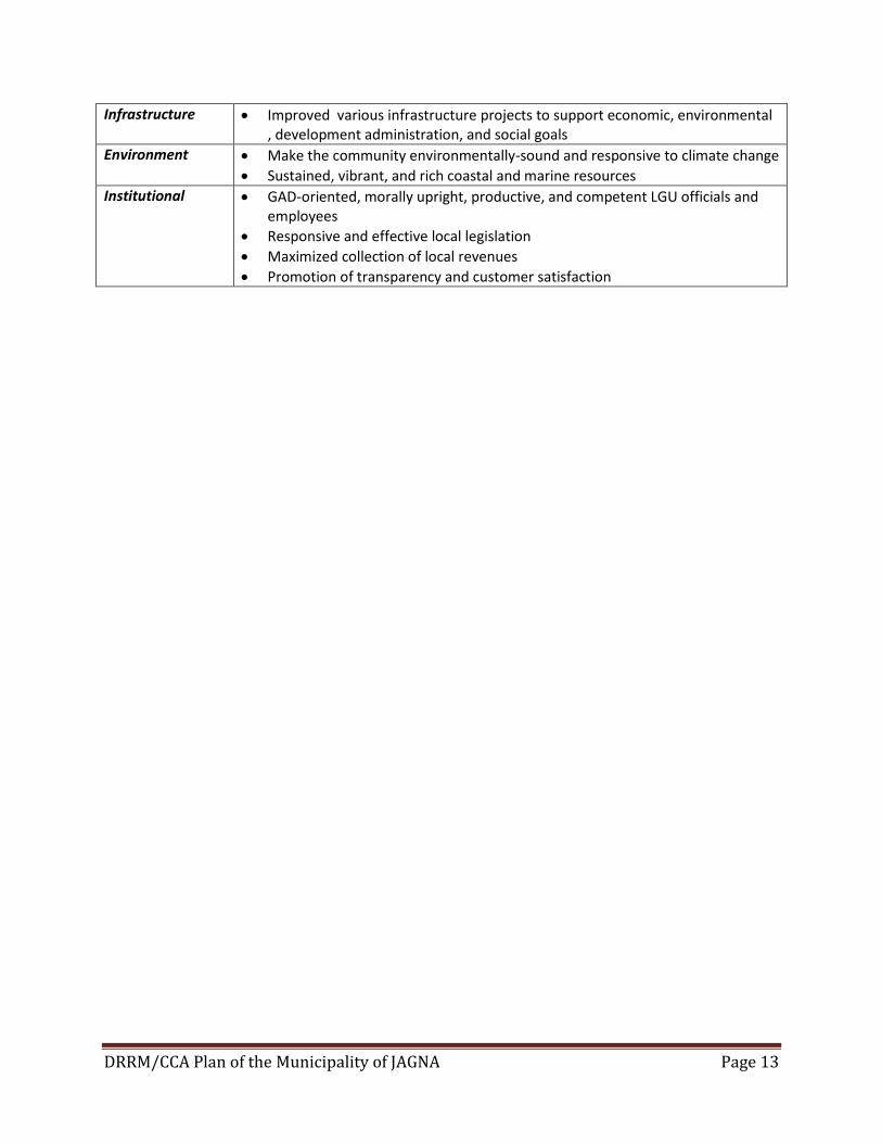
Infrastructure Improved various infrastructure projects to support economic, environmental , development administration, and social goals
Environment Make the community environmentally-sound and responsive to climate change
Sustained, vibrant, and rich coastal and marine resources
Institutional GAD-oriented, morally upright, productive, and competent LGU officials and employees
Responsive and effective local legislation
Maximized collection of local revenues
Promotion of transparency and customer satisfaction
DRRM/CCA Plan of the Municipality of JAGNA Page 14
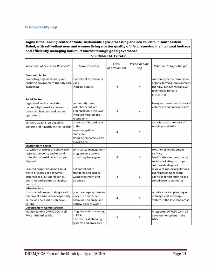
Vision-Reality Gap
Indicators of “Disaster Resilient” Current RealityLevel
of Attainment
Vision-Reality
GapWhat to do to fill the gap
Economic Sector
promoting organic farming and
ensuring environment friendly agro-
processing
majority of the farmers
uses
inorganic inputs 3 7
continuing demo farming on
organic farming, environment
friendly, gender responsive
technology for agro-
processing
Social Sector
organized and capacitated
community-based volunteers in
times of disasters and rescue
operations
community-based
volunteers not yet
organized only the LGU
initiated medical and
rescue unit
3 7
to organize community-based
volunteers and rescue teams,
vigilant citizens on possible
danger and hazards in the locality
unaware of hazard risks
in the
area susceptible to
landslide,
flooding,tsunamis,earth
quakes,etc.
4 6
capacitate thru conduct of
trainings and drills
Environment Sector
sustained practices of solid waste
segregation policy and expand
collection of residual and proper
disposal
solid waste management
program only covers
urbanizing barangays 4 6
continuing development
sanitary
landfill sites and continuous
social marketing on proper
solid waste disposal
Ensured proper liquid and solid
waste disposals of economic
enterprises e.g. funeral parlor,
poultries and pigeries, slaughter
house, etc.
not compliant to
standards and proper
waste treatment and
disposals
4 6
review of zoning regulations,
coordination to concern
agencies for monitoring and
compliance to standards
Infrastructure
constructed proper drainage and
catchment basin system especially
in lowland areas like Poblacion-
Tejero
poor drainage system in-
placed, no catchment
basin, no sewerage and
narrow exits of water
4 6
requires master planning on
drainage and sewerage
system in the low-land areas
Development Administration
mainstreaming DRRM/CCA in all
PPAs initiated by LGU
on-going mainstreaming
in PPAs
into the local planning
systems and processes
5 5
integrating DRRM/CCA in all
development plans in the
LGUs
Jagna is the leading center of trade, sustainable agro-processing and eco-tourism in southeastern
Bohol, with self-reliant men and women living a better quality of life, preserving their cultural heritage
and efficiently managing natural resources through good governance.
VISION-REALITY GAP
DRRM/CCA Plan of the Municipality of JAGNA Page 15
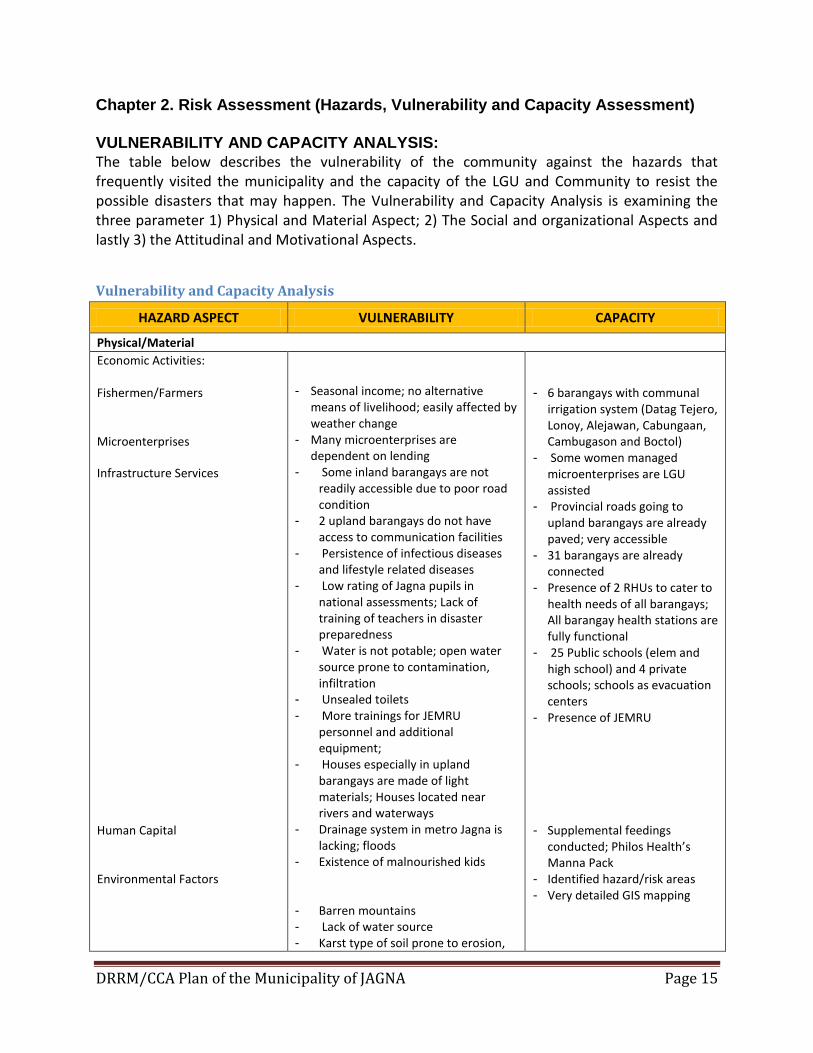
Chapter 2. Risk Assessment (Hazards, Vulnerability and Capacity Assessment)
VULNERABILITY AND CAPACITY ANALYSIS:
The table below describes the vulnerability of the community against the hazards that frequently visited the municipality and the capacity of the LGU and Community to resist the possible disasters that may happen. The Vulnerability and Capacity Analysis is examining the three parameter 1) Physical and Material Aspect; 2) The Social and organizational Aspects and lastly 3) the Attitudinal and Motivational Aspects.
Vulnerability and Capacity Analysis
HAZARD ASPECT VULNERABILITY CAPACITY
Physical/Material
Economic Activities: Fishermen/Farmers Microenterprises
Infrastructure Services Human Capital Environmental Factors
- Seasonal income; no alternative means of livelihood; easily affected by weather change
- Many microenterprises are dependent on lending
- Some inland barangays are not readily accessible due to poor road condition
- 2 upland barangays do not have access to communication facilities
- Persistence of infectious diseases and lifestyle related diseases
- Low rating of Jagna pupils in national assessments; Lack of training of teachers in disaster preparedness
- Water is not potable; open water source prone to contamination, infiltration
- Unsealed toilets
- More trainings for JEMRU personnel and additional equipment;
- Houses especially in upland barangays are made of light materials; Houses located near rivers and waterways
- Drainage system in metro Jagna is lacking; floods
- Existence of malnourished kids
- Barren mountains - Lack of water source - Karst type of soil prone to erosion,
- 6 barangays with communal
irrigation system (Datag Tejero, Lonoy, Alejawan, Cabungaan, Cambugason and Boctol)
- Some women managed microenterprises are LGU assisted
- Provincial roads going to upland barangays are already paved; very accessible
- 31 barangays are already connected
- Presence of 2 RHUs to cater to health needs of all barangays; All barangay health stations are fully functional
- 25 Public schools (elem and high school) and 4 private schools; schools as evacuation centers
- Presence of JEMRU
- Supplemental feedings conducted; Philos Health’s Manna Pack
- Identified hazard/risk areas - Very detailed GIS mapping
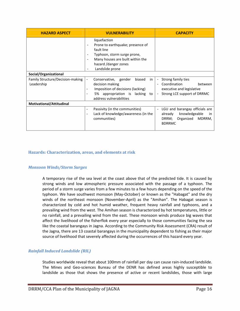
DRRM/CCA Plan of the Municipality of JAGNA Page 16
HAZARD ASPECT VULNERABILITY CAPACITY
liquefaction - Prone to earthquake; presence of
fault line - Typhoon, storm surge prone, - Many houses are built within the
hazard /danger zones - Landslide prone
Social/Organizational
Family Structure/Decision-making Leadership
- Conservative, gender biased in decision making
- Imposition of decisions (lacking) - 5% appropriation is lacking to
address vulnerabilities
- Strong family ties - Coordination between
executive and legislative - Strong LCE support of DRRMC
Motivational/Attitudinal
- Passivity (in the communities) - Lack of knowledge/awareness (in the
communities)
- LGU and barangay officials are already knowledgeable in DRRM; Organized MDRRM, BDRRMC
Hazards: Characterization, areas, and elements at risk
Monsoon Winds/Storm Surges
A temporary rise of the sea level at the coast above that of the predicted tide. It is caused by strong winds and low atmospheric pressure associated with the passage of a typhoon. The period of a storm surge varies from a few minutes to a few hours depending on the speed of the typhoon. We have southwest monsoon (May-October) or known as the "Habagat" and the dry winds of the northeast monsoon (November-April) as the "Amihan". The Habagat season is characterized by cold and hot humid weather, frequent heavy rainfall and typhoons, and a prevailing wind from the west. The Amihan season is characterized by hot temperatures, little or no rainfall, and a prevailing wind from the east. These monsoon winds produce big waves that affect the livelihood of the fisherflok every year especially to those communities facing the sea like the coastal barangays in Jagna. According to the Community Risk Assessment (CRA) result of the Jagna, there are 13 coastal barangays in the municipality dependent to fishing as their major source of livelihood that severely affected during the occurrences of this hazard every year.
Rainfall Induced Landslide (RIL)
Studies worldwide reveal that about 100mm of rainfall per day can cause rain-induced landslide. The Mines and Geo-sciences Bureau of the DENR has defined areas highly susceptible to landslide as those that shows the presence of active or recent landslides, those with large
DRRM/CCA Plan of the Municipality of JAGNA Page 17
tension cracks that would affect the community, areas with drainages that are prone to landslide damming and those with steep slopes of from 21% to 55%. In Jagna, an estimated area of 11,657 hectares are prone to rain induced landslide(RIL). This RIL are influence of infiltration under various rainfall, ground conditions on slope stability. Ground conditions on slope stability is still poorly understood and is one considered major geotechnical hazard. These are barangays of Mayana, Boctol, Balili, Buyog, Cantuyoc, Malbog, Odiong, Laca, Kinagbaan,T-monte and Bunga-Ilaya. Heavy surface run off is observed immediately after heavy rain occurred due to poor water holding capacity in these areas. Rainfall induced landslide is caused by the saturation of the soil with rainwater thereby causing mass movement. Human activities such as slope farming, land development and conversion, can also increase landslide susceptibility of an area. Land use can be a big factor in rainfall induced landslide. Agricultural land with high water seepage was converted into roads, buildings or houses which dramatically decrease the soils ability to absorb water.
Flooding/Flashfloods
A flood is an overflow of an expanse of water that submerges land as a covering by water of land
not normally covered by water. Flooding may result from the volume of water within a body of
water, such as a river or lake, which overflows or breaks levees. Mostly occur in rivers, when
flow exceeds the capacity of the river channel, particularly at bends or meanders. Floods often
cause damage to homes and businesses if they are placed in natural flood plains of rivers.
Most flooding in the municipality of Jagna occurs on floodplains. These are natural water
storage areas containing rivers or creeks that flow continuously or intermittently. Historically,
the easy access to water and the rich diversity and fertility of the flood plains have always
attracted by human settlements. These are barangays of Tejero, Poblacion, Pagina, Looc, Can-
upao and Bunga Mar. Hence, with the ever-increasing human intervention in the upstream
catchments, the downstream consequences and risks increase. It is observed that the flood
prone areas with state height of floods that range from 0.4 meters to 1.2 meters high during
heavy rains, more so during high tides, are in the barangays of Looc (0.4m), Tejero (0.5m),
Pagina (1m), Pondol, Poblacion (1m), Can-upao (1.2) and Bunga Mar (1.2m. Since flooding is a
natural hazard and it is affected annually by intensive tropical weather patterns which resulted
to a very significant financial cost and personal hardship within the affected areas in the
municipality. It is also often exacerbated by ignorant and negligent human intervention in the
environment.
Sea Level Rise
Sea levels around the world are rising. Current sea-level rise potentially impacts human
populations (e.g., those living in coastal regions and on islands) and the natural environment
DRRM/CCA Plan of the Municipality of JAGNA Page 18
(e.g., marine ecosystems). Global average sea level rose at an average rate of around 1.7 ± 0.3
mm per year from 1950 to 2009 and at a satellite-measured average rate of about 3.3 ± 0.4 mm
per year from 1993 to 2009, an increase on earlier estimates.It is unclear whether the increased
rate reflects an increase in the underlying long-term trend.
Two main factors contributed to observed sea level rise. The first is thermal expansion: as ocean
water warms, it expands. The second is from the contribution of land-based ice due to increased
melting. The major store of water on land is found in glaciers and ice sheets.
Sea level rise is one of several lines of evidence that support the view that the climate has
recently warmed. It is likely that human-induced (anthropogenic) warming contributed to the
sea level rise observed in the latter half of the 20th century.
Sea level has been rising has been observe in coastal barangays in Jagna as a result of human-
induced climate change sea level rose approximately about 15-20 centimeters (roughly 1.5 to
2.0 mm/year). Some fisher folks can attest that seashore area comes shorter and volume of
water run-off were observe during high tides in barangay Bunga Mar or even in the Poblacion
area were water were reaches to the tennis court in barangay Poblacion.
Mass Movement of Soil
Mass movement is the movement downhill of weathered rock material (regolith soil, loose
stones and rocks) under the influence of gravity. In mass movement, soil, loose stone and rock
material falls, rolls, slides or flows downhill. It is caused by natural processes such as excessive
rain, rapid undercutting by rivers or sea waves, or by human activities. Areas susceptible to
landslides usually include old landslide deposits along, near or beneath steep slopes and
downslopes of streams and creeks. Thick soil or fractured rocks; areas along or on top of cut
slopes; and developed steep slopes with no appropriate drainage. Even without the use of maps
it is possible to identify active landslide areas by looking at telltale signs like cracks or scars,
surface depressions, disturbance of the drainage pattern, hammock-like topography and
earlobe-like bulges near the base of slopes.
In Barangay Mayana, the very large (52 ha. as of 13 August 2005) landslide originated as a rock
fall along a very steep NW-trending fault scarp in the Sierra Bullones Limestone in Sitio
Balikbayan. The rock falls started on 11 July 2005. Earlier, a surface-wave magnitude 4.9
earthquake with epicenter in Sierra Bullones (about 46 km east of Tabilaran City) occurred at
8:25 p.m. on 31 March 2005. The epicenter is roughly only 8 km west of the site of the landslide
occurrence and is probably related to the movement along the East Bohol Fault. No typhoon
had affected the province more than half a year before the landslide. The earthquake probably
triggered the landslide in Barangay Mayana. The debris fell on an area underlain by older
limestone landslide debris and thickly weathered soils from the underlying volcaniclastic rocks
DRRM/CCA Plan of the Municipality of JAGNA Page 19
of the Late Miocene Carmen Formation. The slope of the landslide is only about 13% (7½º). The
landslide is elongate, oriented east-west, and has a total length of 1.4 km as of 13 August, 2005.
In the findings and recommendations of the MGB, DENR R7,there is an indication of a possible
presence of a fault of which movement of this inferred fault in the past could have caused the
development of fractures and joints in the limestone and underlying rock formation;.Observed
fracturing and minor rock falls on the limestone in the past indicate that the site has undergone
minor slope or ground movement . The causes of the landslide: presence of cavities within the
limestone formation; periodic lowering (caused by shrinkage and compaction) and increase in
ground level (buoyant effect on rocks) which affected stability of the formation. The landslide is
active and could affect houses along its east directed movement
Recommendations that people should be restricted from venturing into the affected zone.
Houses near the periphery of the affected area should be relocated immediately as well as
those along the path of the landslide debris. Regular monitoring of the advance of the landslide
debris. Residents should be vigilant during the rainy period since this could trigger the debris to
move faster and should report the presence of new new cracks/fractures.
Earthquake
An earthquake is a shaking of the ground caused by the sudden breaking and movement of large
sections (tectonic plates) of the earth's rocky outermost crust. The edges of the tectonic plates
are marked by faults (or fractures). Most earthquakes occur along the fault lines when the
plates slide past each other or collide against each other.
On February 8, 1990, a tectonic earthquake with magnitude 6.8, struck the island of Bohol at
3:15 pm, caused panic to general public, damaged several houses and infrastructure and
presented several geologic disturbances. Its epicenter was located about 17 kilometers east of
Tagbilaran City with a maximum felt intensity of VIII, based on Rossi-Forel Intensity Scale, in the
towns of Jagna, Duero and Guindulman all situated on the lower area of the NE quadrant of the
island.
Observed geologic phenomena related to this event include ground fissures, landslides,
rockfalls, ground subsidence and collapse, sand/mud fountaining and sudden increase on the
sea level. Most of the manifestations were particularly observed and experienced by the towns
of Jagna, Valencia, Duero, Guindulman and Garcia Hernandez. The force of the incoming waves
from the sea caused Alijuan River in Duero to flow inland immediately after the earthquake.
Based on the orientation of the main fracture zones, focal mechanism solution and aftershock
distribution, the earthquake may have represented subsurface rupture along segments of the
NE-SW Alicia thrust fault. Studies by the Bureau of Mines (1986), however, point to the fact that
DRRM/CCA Plan of the Municipality of JAGNA Page 20
in most portion of the fault is being overlained by Miocene to recent limestone which does not
reflect any deformation suggesting that the fault has been inactive for quite a long time. This
would pose a question as to whether the earthquake represented reactivation of an old fault or
indicated new fault movement in the island.
The bridge connecting the towns of Jagna and Duero collapsed. Roads to Anda sustained cracks
and fissuring. Landslides and rockfalls blocked some portions of the roads that caused
inaccessibility to some areas between Anda and Garcia Hernandez.Six fatalities were reported
and more than 200 were injured in the event. About 46,000 people were displaced by the event
and at least 7,000 among them were rendered homeless. Estimated damage to properties is
amounting to 154 million pesos. (PHIVOLCS)
Earthquake Fault line and Tsunami
Minor and major fault lines are evident on the island as shown by terraced encarpments occurring in its southern and central parts. Earthquakes have been felt in the municipality but only an average of one perceptible shock is reported each year. As expected thirteen (13) barangays located in coastal zone are exposed to tsunami. These are located in Can-uba, Ipil, Cantagay, Bunga Mar, Bunga Ilaya, Can-upao, Looc, Poblacion (Pondol), Tejero, Pangdan, Alejawan and Naatang.
Disease Outbreak
A disease outbreak is the occurrence of cases of disease in excess of what would normally be
expected in a defined community, geographical area or season. An outbreak may occur in a
restricted geographical area, or may extend over across provinces. It may last for a few days or
weeks, or for several years.
A single case of a communicable disease long absent from a population, or caused by an agent
(e.g. bacterium or virus) not previously recognized in that community or area, or the emergence
of a previously unknown disease, may also constitute an outbreak and should be reported and
investigated.
The most possible outbreaks that may occur in the municipality are dengue fever, diarrheal and
typhoid. Dengue fever is an infectious tropical disease caused by the dengue virus. Symptoms
include fever, headache, muscle and joint pains, and a characteristic skin rash that is similar to
measles. In a small proportion of cases the disease develops into the life-threatening dengue
hemorrhagic fever, resulting in bleeding, low levels of blood platelets and blood plasma leakage,
DRRM/CCA Plan of the Municipality of JAGNA Page 21
or into dengue shock syndrome, where dangerously low blood pressure occurs. Dengue is
transmitted by several species of mosquito within the genus Aedes, principally A. aegypti. The
virus has four different types; infection with one type usually gives lifelong immunity to that
type, but only short-term immunity to the others.
Diarrhea is the condition of having three or more loose or liquid bowel movements per day. It is
a common cause of death in developing countries and the second most common cause of infant
deaths worldwide. The loss of fluids through diarrhea can cause dehydration and electrolyte
disturbances such as potassium deficiency or other salt imbalances.
Typhoid is a common worldwide bacterial disease, transmitted by the ingestion of food or water
contaminated with the feces of an infected person, which contain the bacterium Salmonella
enterica, serovar Typhi. The bacteria then perforate through the intestinal wall and are
phagocytosed by macrophages. The organism is a Gram-negative short bacillus that is motile
due to its peritrichous flagella. The bacterium grows best at 37°C / 98.6°F – human body
temperature.
Agricultural Pest and Disease
The major disease and pests affecting the municipality is in the coconut industry include the Cadang-cadang Disease and the Brontispa Longissima which have caused severe losses to major coconut- producing regions in the country and other coconut –producing countries in the world. Jagna is endangered by these pests and disease because of its proximity and transport accessibility to affected provinces thus posing a serious threat to the coconut industry which is a major means of livelihood in the region.
Grass/ Forest Fire
Grass/Forest Fire become a disaster when combustion of carbon-based materials and oxygen goes out of control and spread fast, threatening human life, homes and other structures. Fires also affect agricultural crops, forest vegetation, and livestock during dry seasons. Forest fire can be ignited by lightning during a sudden storm. It could also be caused by burning agricultural wastes in adjoining farms or grazing areas without fire breaks. Most of the grass fire occurred in Barangay Tejero and Tubod Monte. Measures to increase resiliency includes continuous conduct of IEC and prohibits burning of farm wastes.
Vulnerabilities of elements at risk
Economic Vulnerabilities
Dependency on single cash crop
DRRM/CCA Plan of the Municipality of JAGNA Page 22
No easily saleable assets or savings
Very few job or work opportunities available
Market closed during disasters
Lack of means to buy food, medicine and shelter material
Community members have no richer relatives or remittances
Local credit from money lenders only available at very high interest rates
Physical Vulnerabilities
House design and structure not strong enough to resist common hazards
Roads and bridges not usable by motor vehicles for some month of the year
No landline telephone communication or poor signal for mobile phones
No protected wells, broken or non-existent irrigation system
Water transmission and distribution lines destroyed by flashfloods
Irrigation dams and canals breached
Electric posts and distribution lines destroyed by storm
Shortage of tools needed to maintain livelihoods or lack of protection from hazards
Individual (male/female) vulnerabilities
Low literacy rates on understanding disaster preparedness
Little knowledge of hazards and how to cope with them; loss of historic experience
Lack of educational or skills training opportunities
Prevalence of illnesses such as malaria, dengue, typhoid, etc.
Women restricted in mobility or dress by the culture
Schooling of children hampered
Lack of able-bodied men or women to farm or do other livelihood activities
Social Vulnerabilities
Family relationships are weak, possibly because of men or women migrating for work
Relationships between different ethnic, religious, class or livelihood groups in the barangays are poor; no habit of helping each other
Adverse psycho-social condition of certain segments of the population especially the elderly, the very young, infirm and persons with disabilities
Community has few or no other social groups
Government service do not reach members of the community
Social stereotyping usually against women; others do not value gifts, skills, abilities and experience
No one in the barangay gives clear and decisive leadership during times of crisis; disputes not settled quickly and/or fairly
DRRM/CCA Plan of the Municipality of JAGNA Page 23
Natural Vulnerabilities
Absence of trees, due to human activity or climatic factors
Surface water not consistently available throughout the year
Fish stocks reduced through over-fishing, siltation or pollution
Limited amount of grazing land available
Soil impoverished due to mono-cropping and erosion
Productive Assets Vulnerabilities
Destruction of productive agricultural areas (crops, livestock) and farm machineries unserviceable
Destruction of tourism-related establishments (resort, spas, restaurants, and café)
Loss of vegetation cover and wildlife
Sources of livelihood affected
Destruction of agricultural lands
Siltation of rivers
Destruction of agricultural, commercial and industrial infrastructures
Low productivity
Loss of marketable products
Capacities of Elements at Risk
Population
People should work better in their own day-to-day affairs and these will include: o elements of human resource development (individual training) o organizational development (improving the functioning of groups and organizations) o institutional development (the formalization of group initiatives into social
structures with legal and regulatory authority to allow efficient functioning of groups and individuals)
Increased environmental awareness to the residents in hazard prone areas
Implementation of continuing environmental programs such proper solid waste management , tree growing activities, dredging and declogging of rivers and creeks, storm drainage, canals and waterways clean-up etc.
The general public will make informed decisions regarding disaster preparedness
Increasingly effective mitigation program ideas will become available.
The political will to implement risk reduction programs will increase.
DRRM/CCA Plan of the Municipality of JAGNA Page 24
Productive Assets
Promote natural farming system that promotes sustainability and an increase in farm yield.
More of the economy can be devoted to development instead of disaster recovery.
Strict implementation of RA 9003 (Ecological Solid Waste Management Act of 2000), PD
856 (Code of Sanitation) and RA 9275 (Philippine Clean Water Act of 2004)
Industrial and commercial activities shall be properly located considering their potential
traffic generation and pollution impact.
Strict zoning regulation shall be enforced on livestock and piggery houses located in
residential areas.
Contour tillage and similar sustainable practices shall be strictly enforced among sloping
land cultivators.
The effects of agricultural chemical residues shall be monitored and regulated.
Environmental impact rather than potential revenue shall be the primary consideration
in granting permits for small-scale mining and quarrying.
Tourism projects shall be evaluated equally for their income generation potential as for
the environmental degradation, displacement of local residents, and moral corruption
that usually accompany these projects.
Infrastructures
Buildings, especially critical facilities, will be more likely to withstand disasters.
Strict implementation of BP 220 Building Code, Structural code and land use and zoning policies
Properly sited and designed so as not to become source of anthropogenic hazards themselves.
Minimized exposure to geo-hydrological hazards.
Retrofit old structures for adaptive reuse to preserve their historical or heritage value.
Establish civil works that assist nature to rehabilitate itself or to maintain its own integrity.
Chapter 3. DRRM AND CCA-SENSITIVE COMPREHENSIVE LAND USE PLAN
Proposed urban form for safe urban settlements The trend alternative reflects the probable scenario of Jagna if the existing conditions are allowed to continue and the direction of present activities will follow its natural course. Urbanization will essentially follow a linear pattern of growth or a ribbon type of development along the areas traversed by the national, provincial and municipal roads. The Barangays Poblacion, Pagina,Looc and Can-upao will be maintained as the central business district and will remain as the core urban
DRRM/CCA Plan of the Municipality of JAGNA Page 25
growth in the municipality. However, there is a need to identify and define the direction of development towards the urbanizing barangays, wherein an expansion of built-up areas is applied as a sub-center that would serve as a production and marketing center of agricultural produced in the town. As a major trading center in the southeastern part of the province, the municipality would become the institutional and settlement center in Bohol. Due to urbanization process, a tremendous demand for land will be expected. Since development is highly concentrated in the urban areas, future activities like the basic services and facilities shall be provided to the strategic barangays mentioned and indicated in the land use plan.
Proposed policies for a risk-sensitive zoning ordinance The whole barangays of Poblacion, Bunga Mar, Can-upao, Looc, Pagina and portion of barangay Canjulao, Tejero and Pangdan are declared as the urban zone or they are officially called now as the Metro Jagna cluster. It is further shown in the official Urban Zoning Map of the municipality.
On Settlements:
Vulnerable settlements particularly where there is the presence of a significant number
belonging to the vulnerable groups that cannot be relocated shall have an operational community-based disaster management plan. Ensure that women and other vulnerable groups are involved in the Hazard Vulnerability and Capacity Assessment (HVCA) mapping and in the formulation of the disaster management planning as well as in the conduct of Damage Assessment & Needs Assessment (DANA) to ensure that their particular situation and specific needs are considered.
Residential use shall enjoy priority over all other uses in the allocation of hazard-free areas.
Restrict or discourage development in hazard-prone areas. Hazard-exposed settlements, urban and rural shall be located to safe areas.
Vulnerable settlements that cannot be relocated shall have an operational community-based disaster management plan.
Multi-storey dwellings shall be sited in safe areas determined by scientific studies, and for evacuation purposes during floods.
Limit development in environmentally sensitive areas such as steep slopes.
Regular monitoring and evaluation of structurally quality of dwellings shall be established in the municipality.
On Infrastructures:
Properly sited and designed so as not to become source of anthropogenic hazards themselves.
Minimized exposure to geo-hydrological hazards. Retrofit old structures for adaptive reuse to preserve their historical or heritage value.
DRRM/CCA Plan of the Municipality of JAGNA Page 26
Establish civil works that assist nature to rehabilitate itself or to maintain its own integrity.
On Production Areas:
Industrial and commercial activities shall be properly located considering their potential traffic generation and pollution impact.
Strict zoning regulation shall be enforced on livestock and piggery houses located in residential areas.
Contour tillage and similar sustainable practices shall be strictly enforced among sloping land cultivators.
The effects of agricultural chemical residues shall be monitored and regulated.
Environmental impact rather than potential revenue shall be the primary consideration in granting permits for small-scale mining and quarrying.
Tourism projects shall be evaluated equally for their income generation potential as for the environmental degradation, displacement of local residents, and moral corruption that usually accompany these projects.
On Protection Areas:
Liberal allocation of open space in heavily populated areas shall be used as a vulnerability-reduction measure.
Encourage the maintenance of greenery in public and private lots not only for amenity but for its carbon sequestration function.
Environmentally critical and hazardous areas shall be properly demarcated and buffered.
The ecological function shall be paramount over economic and other considerations when allowing the use of protected areas
On Health and Well Being (including Human capital): Access to minimum standards in disaster response as set forth in the Humanitarian Charter including need for water, sanitation, nutrition, food, shelter, clothing, healthcare and others.
Physical ability to labor and good health maintained in normal times through adequate food and nutrition, hygiene and health care.
Food supplies and nutritional status secure (e.g. through reserve stocks of grain and other staple foods managed by communities, with equitable distribution system during food crises).
Access to sufficient quantity and quality of water for domestic needs during crises.
Community structures and culture support self confidence and can assist management of psychological consequences of disasters (trauma, PTSD).
DRRM/CCA Plan of the Municipality of JAGNA Page 27
Community health care facilities and health workers, equipped and trained to respond to physical and mental health consequences of disasters and lesser hazard events, and supported by access to emergency health services, medicines, etc.
On Sustainable Livelihoods
High level of economic activity and employment particularly among the vulnerable groups (ensuring that women have sustainable livelihood and income by providing them with skills training and inputs).
Equitable distribution of wealth and livelihood assets in community
Livelihood diversification (household and community level), including on-farm and off-farm activities in rural areas
Adoption of hazard-resistant agricultural practices (e.g. soil and water conservation methods, cropping patterns geared to low or variable rainfall, hazard-tolerant crops) for food security
Enterprises have business protection and continuity/recovery plans by including risk register management particularly of micro-enterprises
Local trade and transport links with markets for products, labor and services protected against hazards and other external shocks
On Physical Protection, Structural and Technical Measures
Community decisions and planning regarding built environment take potential natural hazard risks into account (including potential for increasing risks through interference with ecological, hydrological, geological systems) and vulnerabilities of different groups.
Security of land ownership/tenancy rights. Low/minimal level of homelessness and landlessness.
Safe locations: community members and facilities (homes, workplaces, public and social facilities) not exposed to hazards in high-risk areas and/or relocated away from unsafe sites.
Structural mitigation measures (embankments, flood diversion channels, water harvesting tanks, etc.) in place to protect against major hazard threats, built using local labor, skills, materials and appropriate technologies as far as possible.
Knowledge and take-up of building codes/regulations throughout community.
Adoption of hazard-resilient construction and maintenance practices for homes and community facilities using local labor, skills, materials and appropriate technologies as far as possible
Community capacities and skills to build, retrofit and maintain structures (technical and organizational).
DRRM/CCA Plan of the Municipality of JAGNA Page 28
Adoption of physical measures to protect items of domestic property (e.g. raised internal platforms and storage as flood mitigation measure, portable stoves) and productive assets (e.g. livestock shelters).
Adoption of short-term protective measures against impending events (e.g. emergency protection of doors/windows from cyclone winds)
Infrastructure and public facilities to support emergency management needs (e.g. shelters, secure evacuation and emergency supply routes). In appropriate cases, provide a separate center for women and their children at the maximum, or bath and toilet facilities and needed privacy for women, girl-child are provided for at the minimum. An emergency response for women and vulnerable groups shall be designed to include search and rescue operations, evacuation management and rehabilitation plans.
Resilient and accessible critical facilities (e.g. health centers, hospitals, police and fire stations - in terms of structural resilience, back-up systems, etc.)
Resilient transport/service infrastructure and connections (roads, paths, bridges, water supplies, sanitation, power lines, communications, etc.)
Safe Building Regulations
Local Sanggunian should enact building ordinance responsive to local needs and peculiarities.
Strictly enforce safe engineering standards.
Retrofit obsolescent but reusable structures.
DRRM/CCA Plan of the Municipality of JAGNA Page 29
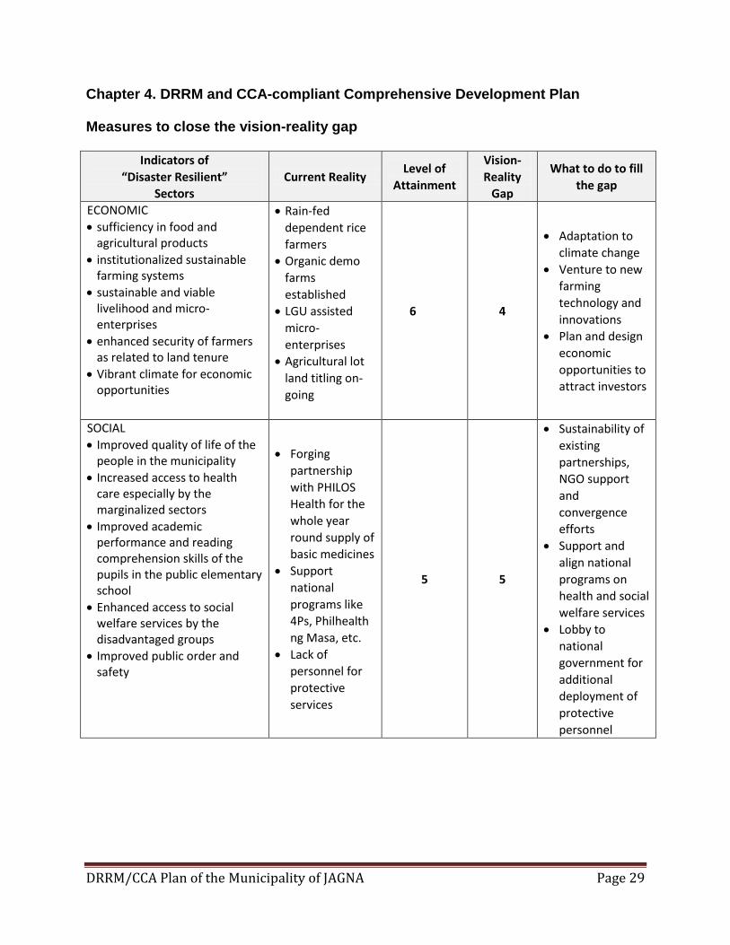
Chapter 4. DRRM and CCA-compliant Comprehensive Development Plan
Measures to close the vision-reality gap
Indicators of
“Disaster Resilient”
Sectors
Current Reality Level of
Attainment
Vision-
Reality
Gap
What to do to fill
the gap
ECONOMIC
sufficiency in food and agricultural products
institutionalized sustainable farming systems
sustainable and viable livelihood and micro-enterprises
enhanced security of farmers as related to land tenure
Vibrant climate for economic opportunities
Rain-fed
dependent rice
farmers
Organic demo
farms
established
LGU assisted
micro-
enterprises
Agricultural lot
land titling on-
going
6 4
Adaptation to
climate change
Venture to new
farming
technology and
innovations
Plan and design
economic
opportunities to
attract investors
SOCIAL
Improved quality of life of the people in the municipality
Increased access to health care especially by the marginalized sectors
Improved academic performance and reading comprehension skills of the pupils in the public elementary school
Enhanced access to social welfare services by the disadvantaged groups
Improved public order and safety
Forging
partnership
with PHILOS
Health for the
whole year
round supply of
basic medicines
Support
national
programs like
4Ps, Philhealth
ng Masa, etc.
Lack of
personnel for
protective
services
5 5
Sustainability of
existing
partnerships,
NGO support
and
convergence
efforts
Support and
align national
programs on
health and social
welfare services
Lobby to
national
government for
additional
deployment of
protective
personnel
DRRM/CCA Plan of the Municipality of JAGNA Page 30
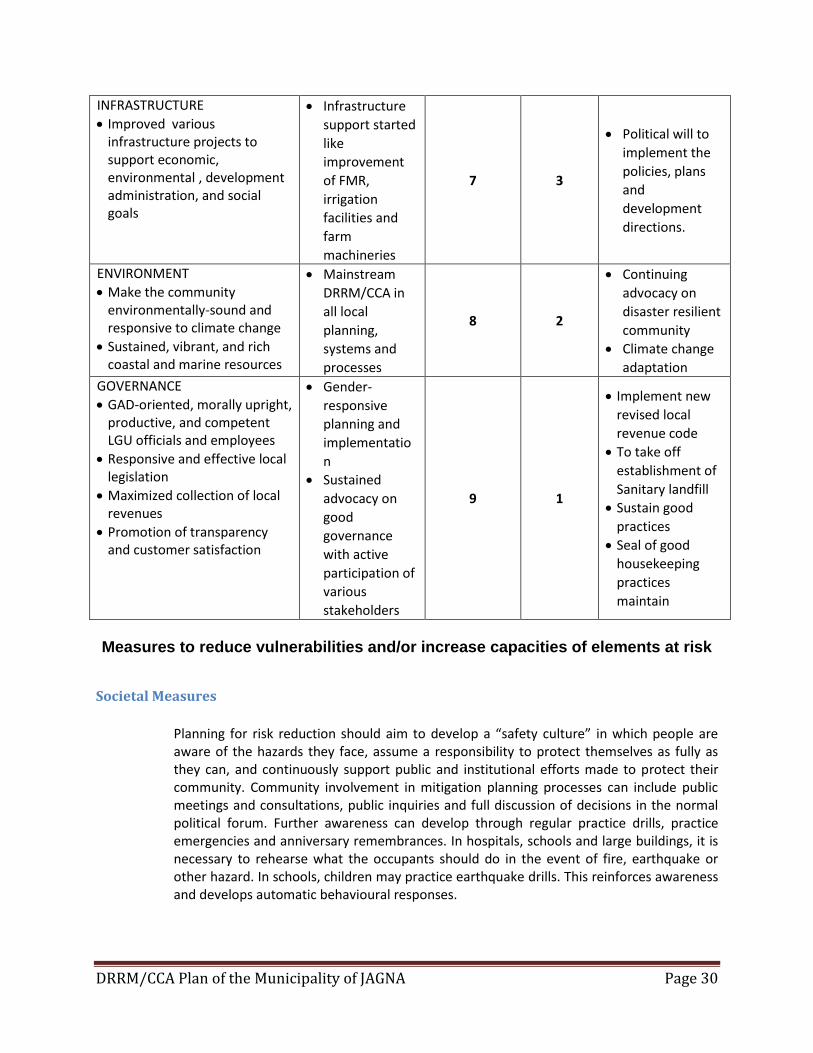
INFRASTRUCTURE
Improved various infrastructure projects to support economic, environmental , development administration, and social goals
Infrastructure
support started
like
improvement
of FMR,
irrigation
facilities and
farm
machineries
7 3
Political will to
implement the
policies, plans
and
development
directions.
ENVIRONMENT
Make the community environmentally-sound and responsive to climate change
Sustained, vibrant, and rich coastal and marine resources
Mainstream
DRRM/CCA in
all local
planning,
systems and
processes
8 2
Continuing
advocacy on
disaster resilient
community
Climate change
adaptation
GOVERNANCE
GAD-oriented, morally upright, productive, and competent LGU officials and employees
Responsive and effective local legislation
Maximized collection of local revenues
Promotion of transparency and customer satisfaction
Gender-
responsive
planning and
implementatio
n
Sustained
advocacy on
good
governance
with active
participation of
various
stakeholders
9 1
Implement new
revised local
revenue code
To take off
establishment of
Sanitary landfill
Sustain good
practices
Seal of good
housekeeping
practices
maintain
Measures to reduce vulnerabilities and/or increase capacities of elements at risk
Societal Measures
Planning for risk reduction should aim to develop a “safety culture” in which people are aware of the hazards they face, assume a responsibility to protect themselves as fully as they can, and continuously support public and institutional efforts made to protect their community. Community involvement in mitigation planning processes can include public meetings and consultations, public inquiries and full discussion of decisions in the normal political forum. Further awareness can develop through regular practice drills, practice emergencies and anniversary remembrances. In hospitals, schools and large buildings, it is necessary to rehearse what the occupants should do in the event of fire, earthquake or other hazard. In schools, children may practice earthquake drills. This reinforces awareness and develops automatic behavioural responses.
DRRM/CCA Plan of the Municipality of JAGNA Page 31
Physical Planning Measures
Many hazards are localized with their likely effects confined to specific well defined areas. Floods occur in flood plains, landslides occur on steep, soft slopes, and so on. The effects can be greatly reduced if it is possible to avoid the use of hazardous areas for settlements or as sites for important structures. Physical planning measures are easiest to implement with public sector facilities, since government has direct control over their funding and placement. The careful location of public sector facilities can play an important role in educating the public and reducing the vulnerability of a settlement. To give priority to land development of relocation sites in the investment programs and not to allow mass settlement in coastal areas too close to the sea.
Economic Measures
Equitable economic development is the key to risk reduction. A strong economy in which the benefits are shared throughout the society is the best protection against a future disaster. Economic development is likely to be the main goal regardless of risk reduction objectives. Some aspects of economic planning are directly relevant to reducing disaster risk. Diversification of economic activity is as important an economic principle as reducing concentration is in physical planning. A single industry (or single-crop) economy is always more vulnerable than an economy made up of many different activities. The linkages between different sectors of an economy—the transportation of goods, the flow of information, the labor market—may be more vulnerable to disruption from a disaster than the physical infrastructure. The reliance of industry and the economy on infrastructure—roads, transportation networks, power, telephone services, etc.—means that a high priority should be placed on protecting these facilities since the consequential losses or failures are costly to the whole community.
Engineering and Construction Measures
Actions to make structures more resistant to hazards primarily involve improvements in design, construction and maintenance of buildings, achieved through institutional means such as design standards, building codes and performance specifications for facilities designed by engineers as well as local builders trained in appropriate construction techniques. Building codes based on disaster-resistance are unlikely to result in stronger buildings unless the engineers and builders who implement them accept their importance and endorse their use. In addition, engineers and builders must understand the code and the design criteria required of them. Responsible authorities must fully enforce the code by checking and penalizing designs that do not comply.
DRRM/CCA Plan of the Municipality of JAGNA Page 32
Regulatory measures to incorporate in the SB’s legislative agenda
Regulatory measures are also a necessary instrument of management in that they seek to prevent or preempt certain socially undesirable actions and behaviours that tend to nullify or neutralize the benefits that may accrue from the positive intervention measures. In the particular case of necessary regulations to implement this DRR/CCA, the municipal zoning ordinance has delineated hazard-prone areas as no-build zones in order to put future settlements permanently out of harm’s way. Other specific regulations will be enacted through single-subject ordinances as the need arises. Strongly suggests to the Sangguniang Bayan to encourage land use application of land use policies and land use planning in disaster management. It needs a strong and responsive political will, commitment and leadership. It is best done through customized adoption.
Activities to be added to functions of existing LGU departments and offices
Build capacities to efficiently manage all types of emergencies and disaster preparedness by designating each department head in the LGU a role how to respond in the event of disaster. A working group should organized to address a functional committees and maximizing their tasks and functions in mainstreaming DRRM/CCA in the LGU systems and processes.
Chapter 5. Implementing the DRRM and CCA Plan
Priority projects for inclusion in the LDIP/AIP 5.1.a Sustainable Jagna Emergency Medical and Rescue Unit (JEMRU) 24/7 Operation 5.1.b Regular dredging and declogging of rivers siltation along Jagna creeks. 5.1.c Construction and rehabilitation of sewerage and drainage in the locality 5.1.d Storm drainage canals and waterways clean-up by its community. 5.1.e Establishment of Jagna ALERT System 5.1.f Continuing Tree Growing Activities in the Lanslide prone areas 5.1.g Developing of early warning device, sea level rise indicator, rain-gauge,etc.
Priority projects for lobbying with the national government 5.1.h Rehabilitation of Flood Control, River Dikes and maintenance works 5.1.i Demolition of riverside area of along Jagna Public Market and develop into promenade
or boulevard. 5.1.j Provision of rubber boat for emergency. 5.1.k Pagina-Looc Riverside Development 5.1.l Rehabilitation/Construction Damaged Wooden Bridges
Hazard-specific Disaster Preparedness Plan 5.1.m Contingency Planning on Landslide Prone Areas
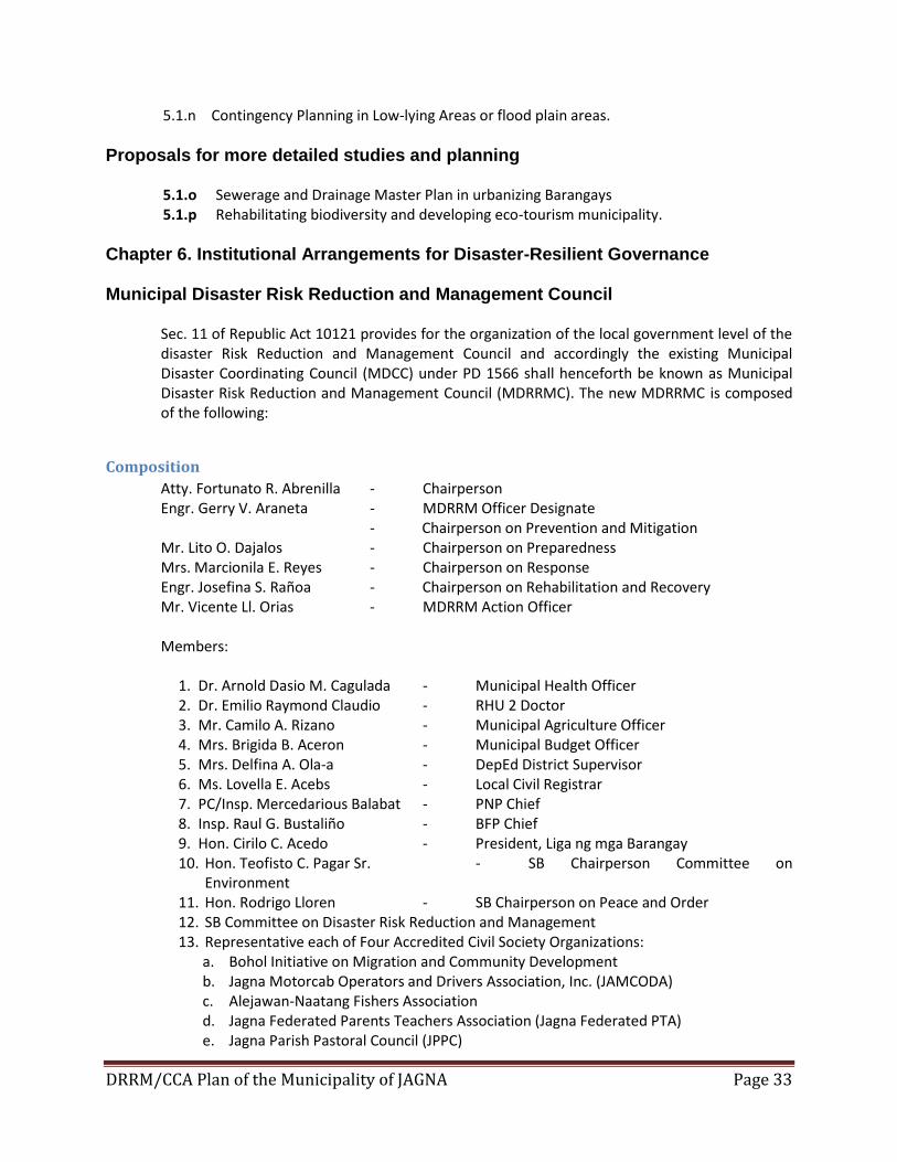
DRRM/CCA Plan of the Municipality of JAGNA Page 33
5.1.n Contingency Planning in Low-lying Areas or flood plain areas.
Proposals for more detailed studies and planning 5.1.o Sewerage and Drainage Master Plan in urbanizing Barangays 5.1.p Rehabilitating biodiversity and developing eco-tourism municipality.
Chapter 6. Institutional Arrangements for Disaster-Resilient Governance
Municipal Disaster Risk Reduction and Management Council Sec. 11 of Republic Act 10121 provides for the organization of the local government level of the disaster Risk Reduction and Management Council and accordingly the existing Municipal Disaster Coordinating Council (MDCC) under PD 1566 shall henceforth be known as Municipal Disaster Risk Reduction and Management Council (MDRRMC). The new MDRRMC is composed of the following:
Composition
Atty. Fortunato R. Abrenilla - Chairperson Engr. Gerry V. Araneta - MDRRM Officer Designate
- Chairperson on Prevention and Mitigation Mr. Lito O. Dajalos - Chairperson on Preparedness Mrs. Marcionila E. Reyes - Chairperson on Response Engr. Josefina S. Rañoa - Chairperson on Rehabilitation and Recovery Mr. Vicente Ll. Orias - MDRRM Action Officer Members:
1. Dr. Arnold Dasio M. Cagulada - Municipal Health Officer 2. Dr. Emilio Raymond Claudio - RHU 2 Doctor 3. Mr. Camilo A. Rizano - Municipal Agriculture Officer 4. Mrs. Brigida B. Aceron - Municipal Budget Officer 5. Mrs. Delfina A. Ola-a - DepEd District Supervisor 6. Ms. Lovella E. Acebs - Local Civil Registrar 7. PC/Insp. Mercedarious Balabat - PNP Chief 8. Insp. Raul G. Bustaliño - BFP Chief 9. Hon. Cirilo C. Acedo - President, Liga ng mga Barangay 10. Hon. Teofisto C. Pagar Sr. - SB Chairperson Committee on
Environment 11. Hon. Rodrigo Lloren - SB Chairperson on Peace and Order 12. SB Committee on Disaster Risk Reduction and Management 13. Representative each of Four Accredited Civil Society Organizations:
a. Bohol Initiative on Migration and Community Development b. Jagna Motorcab Operators and Drivers Association, Inc. (JAMCODA) c. Alejawan-Naatang Fishers Association d. Jagna Federated Parents Teachers Association (Jagna Federated PTA) e. Jagna Parish Pastoral Council (JPPC)
DRRM/CCA Plan of the Municipality of JAGNA Page 34
Functions. – The MDRRMC shall have the following functions:
1. Approve, monitor and evaluate the implementation of the LDRRMP and regularly review and test the plan consistent with other national and local planning programs;
2. Ensure the integration of disaster risk reduction and climate change adaptation into local development plans, programs and budgets as a strategy in sustainable development and poverty reduction;
3. Recommend the implementation of forced or preemptive evacuation of local residents, if necessary; and
4. Convene the local council once every three months or as necessary.
Creation of Local Disaster Risk Reduction and Management Office (LDRRMO).
To assist the MDRRMC, there shall be created a Municipal Disaster Risk Reduction and Management Office (MDRRMO) which shall be under the Office of the Mayor. Initially, it shall be headed by Mr. Vicente Ll. Orias Administrative Aide IV of MPDC Office as MDRRM Action Officer and three (3) staff designate from MPDO responsible for:
a) Administration and Training – Mr. Lindley Galolo b) Research and Planning – Ms. Amiela S. Balaba c) Operation and Warning – Mr. Balbino Balaba
Function of LDRRMO. – The LDRRMO shall have the following functions:
a) Design, program, and coordinate disaster risk reduction and management activities consistent with the National Council’s standards and guidelines;
b) Facilitate and support risk assessments and contingency planning activities at the local level;
c) Consolidate local disaster risk information which includes natural hazards, vulnerabilities, and climate change risks, and maintain a local risk map;
d) Organize and conduct training, orientation, and knowledge management activities on disaster risk reduction and management at the local level;
e) Operate a multi-hazard early warning system, linked to disaster risk reduction to provide accurate and timely advice to national or local emergency response organizations and to the general public, through diverse mass media, particularly radio, landline communications, and technologies for communication within rural communities.
f) Formulate and implement a comprehensive and integrated LDRRMP in accordance with the national, regional and provincial framework, and policies on disaster risk reduction in close coordination with the local development councils (LDCs);
g) Prepare and submit to the local sanggunian through the LDRRMC and the LDC the annual LDRRMO Plan and budget, the proposed programming of the LDRRMF, other dedicated disaster risk reduction and management resources, and other regular funding source/s and budgetary support of the LDRRMO / BDRRMC;
DRRM/CCA Plan of the Municipality of JAGNA Page 35
h) Conduct continuous disaster monitoring and mobilize instrumentalities and entities of the LGUs, CSOs, private groups and organized volunteers, to utilize their facilities and resources for the protection and preservation of life and properties during emergencies in accordance with existing policies and procedures;
i) Identify, assess and manage the hazards, vulnerabilities and risks that may occur in their locality;
j) Disseminate information and raise public awareness about those hazards, vulnerabilities and risks, their nature, effects, early warning signs and countermeasures;
k) Identify and implement cost-effective risk reduction measures/strategies; l) Maintain a database of human resource, equipment, directories, and location of critical
infrastructures and their capacities such as hospitals and evacuation centers; m) Develop, strengthen and operationalize mechanisms for partnership or networking with
private sector, CSOs, and volunteer groups; n) Take all necessary steps on a continuing basis to maintain, provide, or arrange the
provision of, or to otherwise make available, suitably-trained and competent personnel for effective civil defense and disaster risk reduction and management in its area;
o) Organize, train, equip and supervise the local emergency response teams and the ACDVs, ensuring that humanitarian aid workers are equipped with basic skills to assist mothers to breastfeed;
p) Respond to and manage the adverse effects of emergencies and carry out recovery activities in the affected area, ensuring that there is an efficient mechanism for immediate delivery of food, shelter and medical supplies for women and children, endeavor to create a special place where internally-displaced mothers can find help with breastfeeding, feed and care for their babies and give support to each other;
q) Within its area, promote and raise public awareness of and compliance with this Act and legislative provisions relevant to the purpose of this Act;
r) Serve as the secretariat and executive arm of the LDRRMC; s) Coordinate other disaster risk reduction and management activities; t) Establish linkage/network with other LGUs for disaster risk reduction and emergency
response purposes; u) Recommend through the LDRRMC the enactment of local ordinances consistent with
the requirements of this Act; v) Implement policies, approved plans and programs of the LDRRMC consistent with the
policies and guidelines laid down in this Act; w) Establish a Provincial/ City/Municipal/Barangay Disaster Risk Reduction and
Management Operations Center; x) Prepare and submit, through the LDRRMC and the LDC, the report on the utilization of
the LDRRMF and other dedicated disaster risk reduction and management resources to the local COA, copy furnished the regional director of the OCD and the Local Government Operations Officer of the DILG; and
y) Act on other matters that may be authorized by the LDRRMC. Meetings. – Pursuant to Item No.4 of the LDRRMCs functions, the Council shall hold meetings once every three (3) months or as may be necessary or when called by the Chairperson;
DRRM/CCA Plan of the Municipality of JAGNA Page 36
Barangay DRRM Committee
Every Barangay has organized its functional Barangay Disaster Risk Reduction and Management Committee (BDRRMC) that composed of barangay officials and civil society groups in the barangays. The punong barangay had appointed its Barangay Disaster Risk Reduction Action Officer who will coordinate and make reports on disaster preparedness activities to the Municipal DRRM Office.
Linkages, Partnerships, and Networks
In collaboration of national and local line agencies including non-government organizations, partnerships and convergence efforts should adhere especially in times of disaster occurrence and calamities. Linkage to provincial, regional and national department of social welfare and development in the event of post assessment when disaster strikes. Strong partnership with Philippine Red Cross – Bohol Chapter, PDRRMC, Office of the Civil Defense and to the National Disaster Risk Reduction and Management Council.
Monitoring and Evaluation
Monitoring and evaluation is the process of gathering, filing, accessing and analyzing information that will enable the Municipal Mayor as Disaster Risk Reduction and Management Council Head to determine the progress of the implementation of the MDRRM Plan, and make timely decisions to ensure that progress is maintained according to schedules and targets. The public dissemination of the outputs of monitoring and evaluation activities enhances transparency in management. The MDRRMO shall be primarily responsible in carrying out monitoring and evaluation activities but whose work shall be reviewed by the Municipal Disaster Risk reduction and Management as the overseeing body of the municipality for disaster risk reduction and management The MDRRMO shall submit a monthly, quarterly and an annual report to the MDRRMC and to the Municipal Mayor informing them of the state of the implementation of the approved MDRRM program/projects for the period. Generally, coastal communities are highly vulnerable to all types of hazards as illustrated in hazard risk maps such as rain-induced landslide, storm surge, tsunami, multi-hazard maps, etc.). Most of these communities are situated in the low lying areas along the coast where major rivers are traversing along the plain leading down to the sea. As a rule of thumb, people on the affected communities are advised to move and position themselves on the designated evacuation areas that are practically elevated and very proximate to them whenever a disaster occur. Incompliance to RA 10121 and Memorandum Circulars on Disaster Risk Reduction issued by the Department of Interior and Local Government (DILG), Municipality of Jagna through its Municipal Disaster Risk Reduction and Management Office (MDRRMO) identified possible evacuation areas in preparation to the worst case scenarios that will happen if typhoon, storm surges, landslide, tsunami and other hazards will occur and affect the municipality.
DRRM/CCA Plan of the Municipality of JAGNA Page 37
The Evacuation Centers/Areas that have been identified are located in elevated areas in Jagna. These Evacuation Center/Areas are the Schools, Multi-Purpose Hall and upland areas of Jagna. The following are the official and identified areas of Malbog Elementary School, Tubod Monte School, Ilihan Hill Area, Faraon Elementary and High School of Brgy Faraon, Kinagbaan Multi-Purpose Hall, Upper Tubod Mar and other upland barangays. MDRRMO in coordination to MDRRMC, have already established the necessary arrangement and protocols to the concerns School Supervisors, and Barangay official on the standard operating procedures (SOP’s) if evacuation is necessary at all times. MDRRMO in coordination to MDRRMC have already established necessary arrangements and protocol to the school supervision and Barangay officials of the identified evacuation center. Adequate signage should be properly installed in strategic places to practically guide evacuees with the way leading to the designated evacuation areas. Likewise continuous IEC and community awareness are regularly done as part of our preparedness activities to raise the awareness of the communities and help build their capacities and eventually become resilient community.
Appendices
Liquefaction Hazard Map
Rain-induced Landslide
Storm Surge Hazard Map
Multi-Hazard Map
Timeline of Disaster happen in Jagna
THE FIVE- YEAR MUNICIPAL DISASTER RISK REDUCTION AND MANAGEMENT PLAN MATRIX
MDRRM Organizational Structure
Over-all Summary of Budget
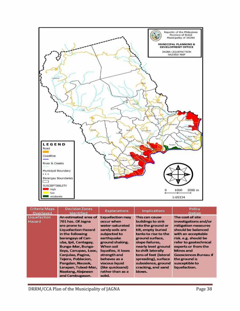
DRRM/CCA Plan of the Municipality of JAGNA Page 38
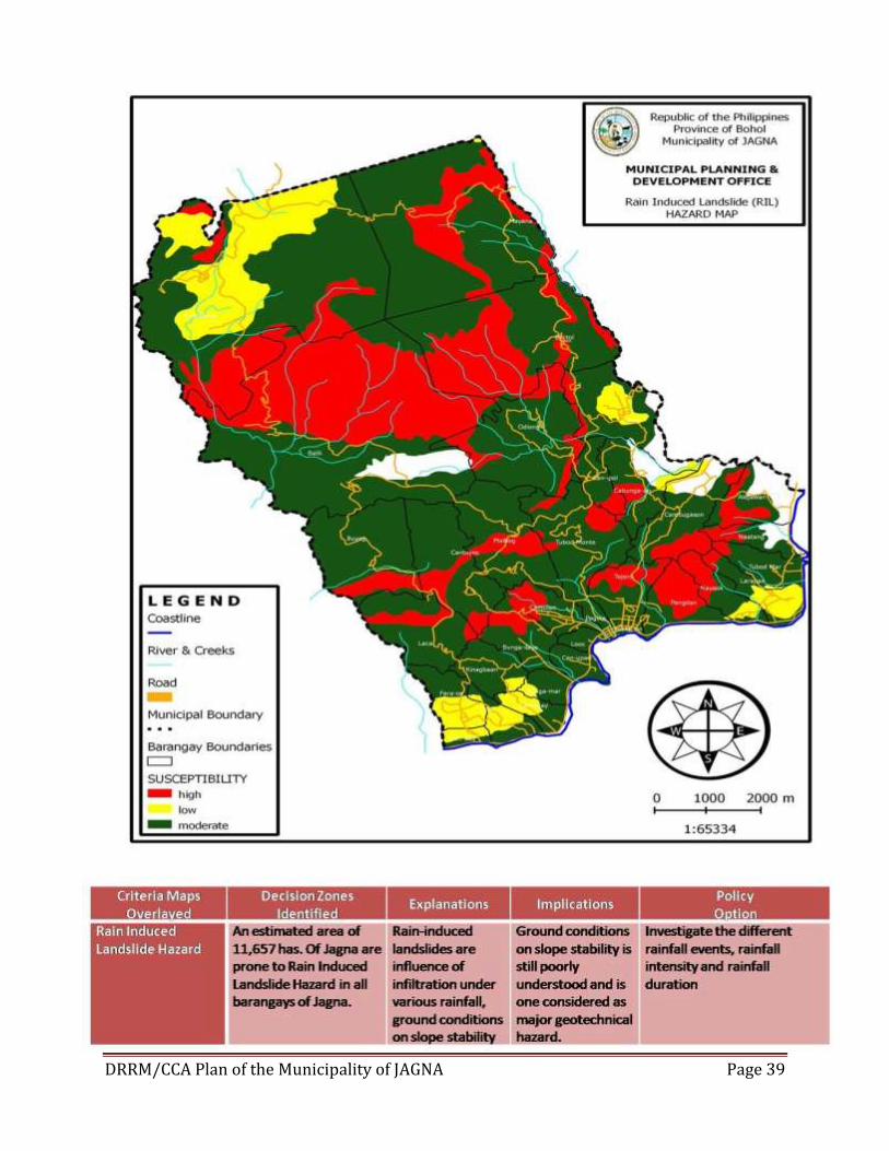
DRRM/CCA Plan of the Municipality of JAGNA Page 39
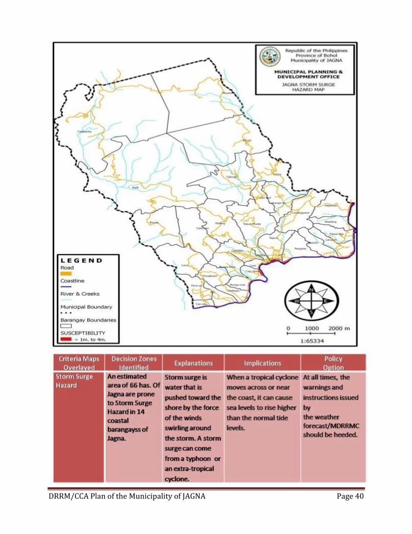
DRRM/CCA Plan of the Municipality of JAGNA Page 40
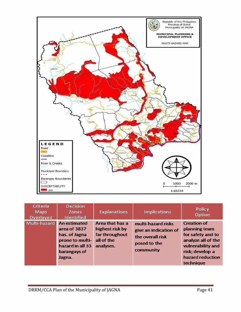
DRRM/CCA Plan of the Municipality of JAGNA Page 41
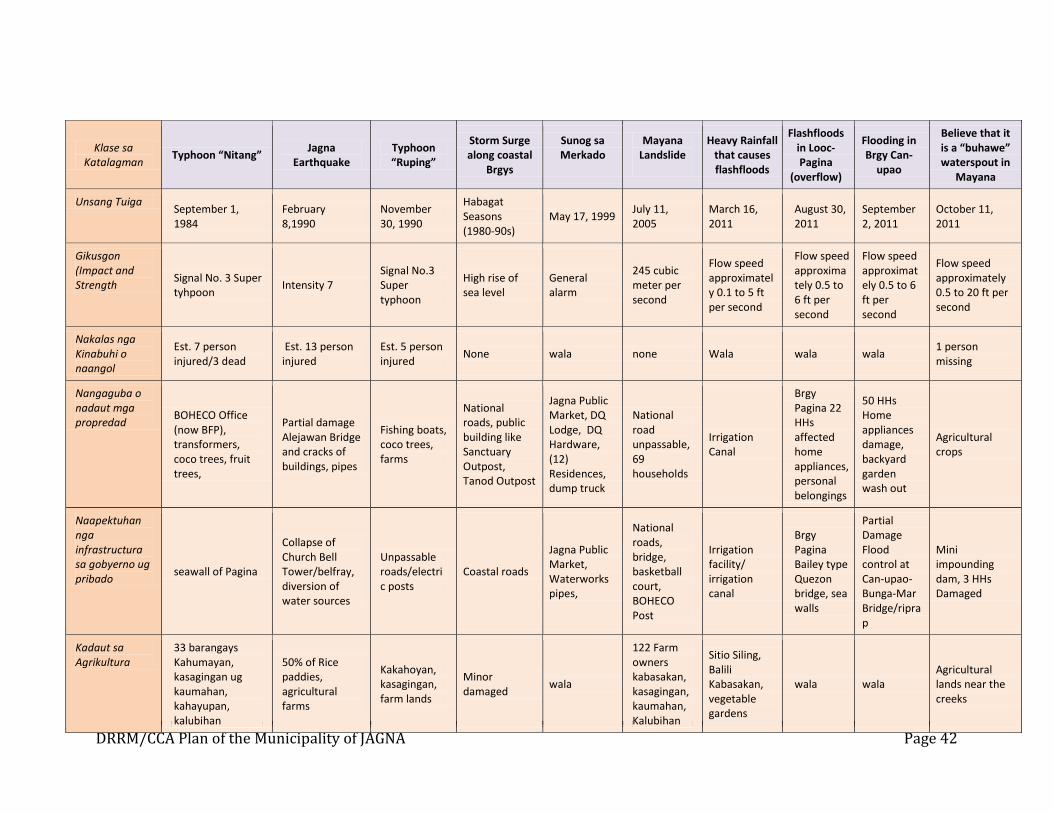
DRRM/CCA Plan of the Municipality of JAGNA Page 42
Klase sa Katalagman
Typhoon “Nitang” Jagna
Earthquake Typhoon “Ruping”
Storm Surge along coastal
Brgys
Sunog sa Merkado
Mayana Landslide
Heavy Rainfall that causes flashfloods
Flashfloods in Looc-Pagina
(overflow)
Flooding in Brgy Can-
upao
Believe that it is a “buhawe” waterspout in
Mayana
Unsang Tuiga September 1, 1984
February 8,1990
November 30, 1990
Habagat Seasons (1980-90s)
May 17, 1999 July 11, 2005
March 16, 2011
August 30, 2011
September 2, 2011
October 11, 2011
Gikusgon (Impact and Strength
Signal No. 3 Super tyhpoon
Intensity 7 Signal No.3 Super typhoon
High rise of sea level
General alarm
245 cubic meter per second
Flow speed approximately 0.1 to 5 ft per second
Flow speed approximately 0.5 to 6 ft per second
Flow speed approximately 0.5 to 6 ft per second
Flow speed approximately 0.5 to 20 ft per second
Nakalas nga Kinabuhi o naangol
Est. 7 person injured/3 dead
Est. 13 person injured
Est. 5 person injured
None wala none Wala wala wala 1 person missing
Nangaguba o nadaut mga propredad
BOHECO Office (now BFP), transformers, coco trees, fruit trees,
Partial damage Alejawan Bridge and cracks of buildings, pipes
Fishing boats, coco trees, farms
National roads, public building like Sanctuary Outpost, Tanod Outpost
Jagna Public Market, DQ Lodge, DQ Hardware, (12) Residences, dump truck
National road unpassable, 69 households
Irrigation Canal
Brgy Pagina 22 HHs affected home appliances, personal belongings
50 HHs Home appliances damage, backyard garden wash out
Agricultural crops
Naapektuhan nga infrastructura sa gobyerno ug pribado
seawall of Pagina
Collapse of Church Bell Tower/belfray, diversion of water sources
Unpassable roads/electric posts
Coastal roads
Jagna Public Market, Waterworks pipes,
National roads, bridge, basketball court, BOHECO Post
Irrigation facility/ irrigation canal
Brgy Pagina Bailey type Quezon bridge, sea walls
Partial Damage Flood control at Can-upao- Bunga-Mar Bridge/riprap
Mini impounding dam, 3 HHs Damaged
Kadaut sa Agrikultura
33 barangays Kahumayan, kasagingan ug kaumahan, kahayupan, kalubihan
50% of Rice paddies, agricultural farms
Kakahoyan, kasagingan, farm lands
Minor damaged
wala
122 Farm owners kabasakan, kasagingan, kaumahan, Kalubihan
Sitio Siling, Balili Kabasakan, vegetable gardens
wala wala Agricultural lands near the creeks
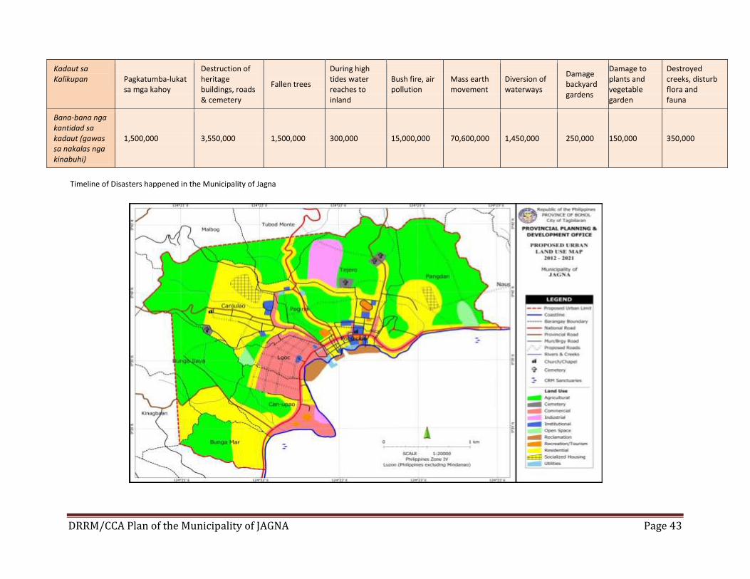
DRRM/CCA Plan of the Municipality of JAGNA Page 43
Timeline of Disasters happened in the Municipality of Jagna
Kadaut sa Kalikupan Pagkatumba-lukat
sa mga kahoy
Destruction of heritage buildings, roads & cemetery
Fallen trees
During high tides water reaches to inland
Bush fire, air pollution
Mass earth movement
Diversion of waterways
Damage backyard gardens
Damage to plants and vegetable garden
Destroyed creeks, disturb flora and fauna
Bana-bana nga kantidad sa kadaut (gawas sa nakalas nga kinabuhi)
1,500,000 3,550,000 1,500,000 300,000 15,000,000 70,600,000 1,450,000 250,000 150,000 350,000
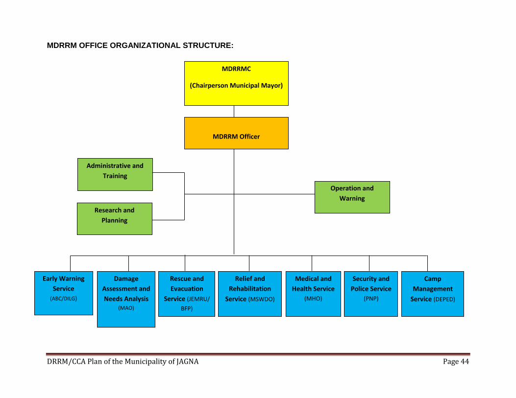
DRRM/CCA Plan of the Municipality of JAGNA Page 44
MDRRM OFFICE ORGANIZATIONAL STRUCTURE:
MDRRMC
(Chairperson Municipal Mayor)
MDRRM Officer
Administrative and
Training
Research and
Planning
Operation and
Warning
Early Warning
Service
(ABC/DILG)
Damage
Assessment and
Needs Analysis (MAO)
Rescue and
Evacuation
Service (JEMRU/
BFP)
Relief and
Rehabilitation
Service (MSWDO)
Medical and
Health Service
(MHO)
Security and
Police Service
(PNP)
Camp
Management
Service (DEPED)
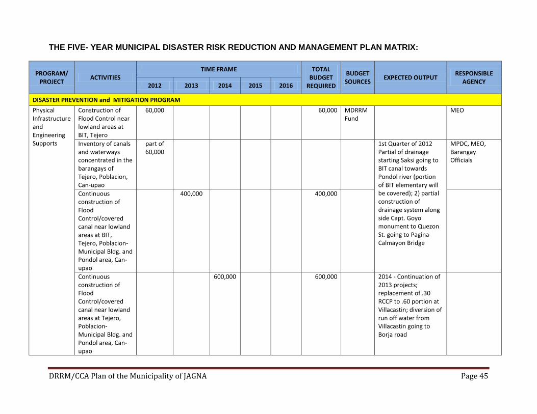
DRRM/CCA Plan of the Municipality of JAGNA Page 45
THE FIVE- YEAR MUNICIPAL DISASTER RISK REDUCTION AND MANAGEMENT PLAN MATRIX:
PROGRAM/ PROJECT
ACTIVITIES TIME FRAME TOTAL
BUDGET REQUIRED
BUDGET SOURCES
EXPECTED OUTPUT RESPONSIBLE
AGENCY 2012 2013 2014 2015 2016
DISASTER PREVENTION and MITIGATION PROGRAM
Physical Infrastructure and Engineering Supports
Construction of Flood Control near lowland areas at BIT, Tejero
60,000 60,000 MDRRM Fund
MEO
Inventory of canals and waterways concentrated in the barangays of Tejero, Poblacion, Can-upao
part of 60,000
1st Quarter of 2012 Partial of drainage starting Saksi going to BIT canal towards Pondol river (portion of BIT elementary will be covered); 2) partial construction of drainage system along side Capt. Goyo monument to Quezon St. going to Pagina-Calmayon Bridge
MPDC, MEO, Barangay Officials
Continuous construction of Flood Control/covered canal near lowland areas at BIT, Tejero, Poblacion-Municipal Bldg. and Pondol area, Can-upao
400,000 400,000
Continuous construction of Flood Control/covered canal near lowland areas at Tejero, Poblacion-Municipal Bldg. and Pondol area, Can-upao
600,000 600,000 2014 - Continuation of 2013 projects; replacement of .30 RCCP to .60 portion at Villacastin; diversion of run off water from Villacastin going to Borja road
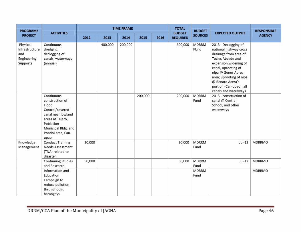
DRRM/CCA Plan of the Municipality of JAGNA Page 46
PROGRAM/ PROJECT
ACTIVITIES TIME FRAME TOTAL
BUDGET REQUIRED
BUDGET SOURCES
EXPECTED OUTPUT RESPONSIBLE
AGENCY 2012 2013 2014 2015 2016
Physical Infrastructure and Engineering Supports
Continuous dredging, declogging of canals, waterways (annual)
400,000 200,000 600,000 MDRRM FUnd
2013 - Declogging of national highway cross drainage from area of Tocles Abcede and expansion;widening of canal, uprooting of nipa @ Genes Abrea area; uprooting of nipa @ Renato Acera's portion (Can-upao); all canals and waterways
Continuous construction of Flood Control/covered canal near lowland areas at Tejero, Poblacion-Municipal Bldg. and Pondol area, Can-upao
200,000 200,000 MDRRM Fund
2015 - construction of canal @ Central School; and other waterways
Knowledge Management
Conduct Training Needs Assessment (TNA) related to disaster
20,000 20,000 MDRRM Fund
Jul-12 MDRRMO
Continuing Studies and Research
50,000 50,000 MDRRM Fund
Jul-12 MDRRMO
Information and Education Campaign to reduce pollution thru schools, barangays
MDRRM Fund
MDRRMO
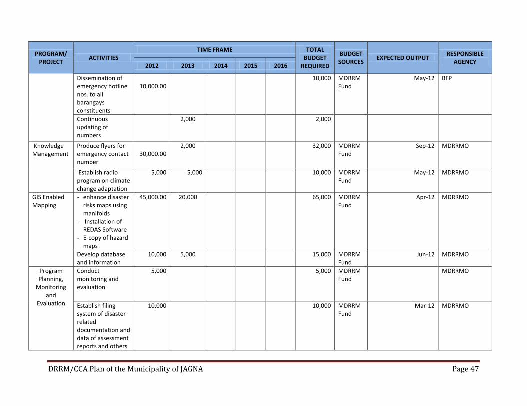
DRRM/CCA Plan of the Municipality of JAGNA Page 47
PROGRAM/ PROJECT
ACTIVITIES TIME FRAME TOTAL
BUDGET REQUIRED
BUDGET SOURCES
EXPECTED OUTPUT RESPONSIBLE
AGENCY 2012 2013 2014 2015 2016
Dissemination of emergency hotline nos. to all barangays constituents
10,000.00
10,000 MDRRM Fund
May-12 BFP
Continuous updating of numbers
2,000 2,000
Knowledge Management
Produce flyers for emergency contact number
30,000.00
2,000 32,000 MDRRM Fund
Sep-12 MDRRMO
Establish radio program on climate change adaptation
5,000 5,000 10,000 MDRRM Fund
May-12 MDRRMO
GIS Enabled Mapping
- enhance disaster risks maps using manifolds
- Installation of REDAS Software
- E-copy of hazard maps
45,000.00 20,000 65,000 MDRRM Fund
Apr-12 MDRRMO
Develop database and information
10,000 5,000 15,000 MDRRM Fund
Jun-12 MDRRMO
Program Planning,
Monitoring and
Evaluation
Conduct monitoring and evaluation
5,000
5,000 MDRRM Fund
MDRRMO
Establish filing system of disaster related documentation and data of assessment reports and others
10,000 10,000 MDRRM Fund
Mar-12 MDRRMO
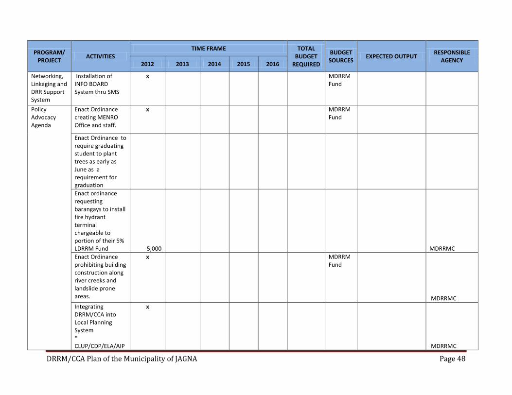
DRRM/CCA Plan of the Municipality of JAGNA Page 48
PROGRAM/ PROJECT
ACTIVITIES TIME FRAME TOTAL
BUDGET REQUIRED
BUDGET SOURCES
EXPECTED OUTPUT RESPONSIBLE
AGENCY 2012 2013 2014 2015 2016
Networking, Linkaging and DRR Support System
Installation of INFO BOARD System thru SMS
x MDRRM Fund
Policy Advocacy Agenda
Enact Ordinance creating MENRO Office and staff.
x MDRRM Fund
Enact Ordinance to require graduating student to plant trees as early as June as a requirement for graduation
Enact ordinance requesting barangays to install fire hydrant terminal chargeable to portion of their 5% LDRRM Fund 5,000
MDRRMC
Enact Ordinance prohibiting building construction along river creeks and landslide prone areas.
x MDRRM Fund
MDRRMC
Integrating DRRM/CCA into Local Planning System * CLUP/CDP/ELA/AIP
x
MDRRMC
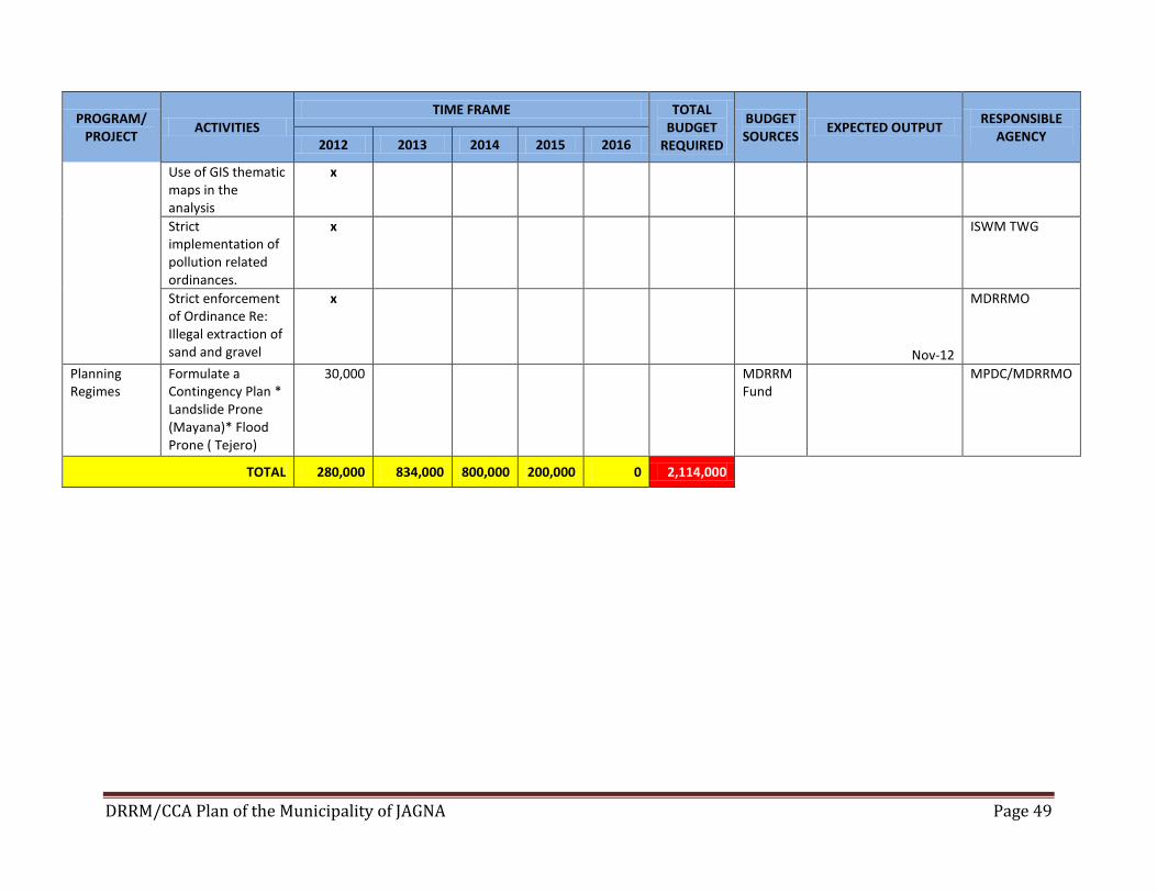
DRRM/CCA Plan of the Municipality of JAGNA Page 49
PROGRAM/ PROJECT
ACTIVITIES TIME FRAME TOTAL
BUDGET REQUIRED
BUDGET SOURCES
EXPECTED OUTPUT RESPONSIBLE
AGENCY 2012 2013 2014 2015 2016
Use of GIS thematic maps in the analysis
x
Strict implementation of pollution related ordinances.
x
ISWM TWG
Strict enforcement of Ordinance Re: Illegal extraction of sand and gravel
x
Nov-12
MDRRMO
Planning Regimes
Formulate a Contingency Plan * Landslide Prone (Mayana)* Flood Prone ( Tejero)
30,000 MDRRM Fund
MPDC/MDRRMO
TOTAL 280,000 834,000 800,000 200,000 0 2,114,000
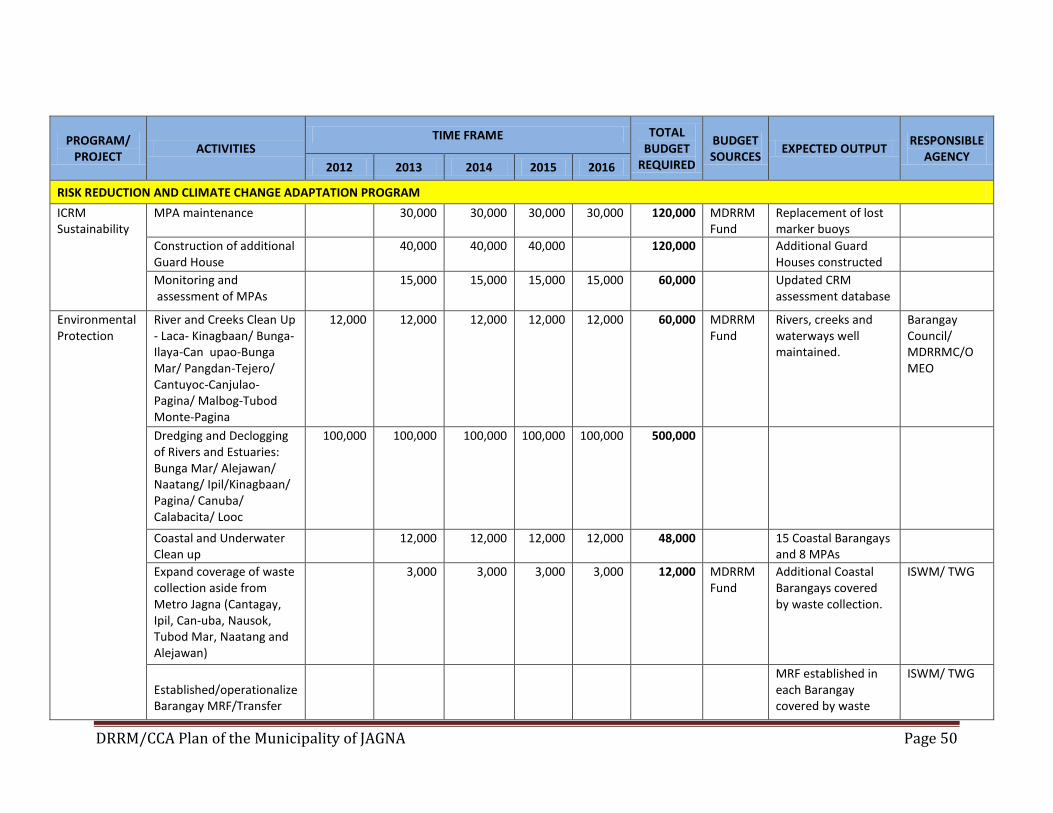
DRRM/CCA Plan of the Municipality of JAGNA Page 50
PROGRAM/ PROJECT
ACTIVITIES TIME FRAME TOTAL
BUDGET REQUIRED
BUDGET SOURCES
EXPECTED OUTPUT RESPONSIBLE
AGENCY 2012 2013 2014 2015 2016
RISK REDUCTION AND CLIMATE CHANGE ADAPTATION PROGRAM
ICRM Sustainability
MPA maintenance 30,000 30,000 30,000 30,000 120,000 MDRRM Fund
Replacement of lost marker buoys
Construction of additional Guard House
40,000 40,000 40,000 120,000 Additional Guard Houses constructed
Monitoring and assessment of MPAs
15,000 15,000 15,000 15,000 60,000 Updated CRM assessment database
Environmental Protection
River and Creeks Clean Up - Laca- Kinagbaan/ Bunga-Ilaya-Can upao-Bunga Mar/ Pangdan-Tejero/ Cantuyoc-Canjulao-Pagina/ Malbog-Tubod Monte-Pagina
12,000 12,000 12,000 12,000 12,000 60,000 MDRRM Fund
Rivers, creeks and waterways well maintained.
Barangay Council/ MDRRMC/O MEO
Dredging and Declogging of Rivers and Estuaries: Bunga Mar/ Alejawan/ Naatang/ Ipil/Kinagbaan/ Pagina/ Canuba/ Calabacita/ Looc
100,000 100,000 100,000 100,000 100,000 500,000
Coastal and Underwater Clean up
12,000 12,000 12,000 12,000 48,000 15 Coastal Barangays and 8 MPAs
Expand coverage of waste collection aside from Metro Jagna (Cantagay, Ipil, Can-uba, Nausok, Tubod Mar, Naatang and Alejawan)
3,000 3,000 3,000 3,000 12,000 MDRRM Fund
Additional Coastal Barangays covered by waste collection.
ISWM/ TWG
Established/operationalize Barangay MRF/Transfer
MRF established in each Barangay covered by waste
ISWM/ TWG
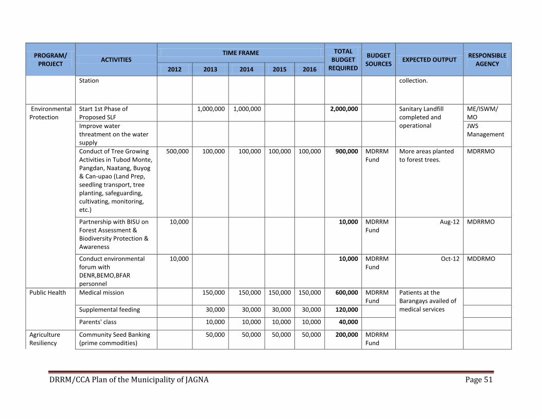
DRRM/CCA Plan of the Municipality of JAGNA Page 51
PROGRAM/ PROJECT
ACTIVITIES TIME FRAME TOTAL
BUDGET REQUIRED
BUDGET SOURCES
EXPECTED OUTPUT RESPONSIBLE
AGENCY 2012 2013 2014 2015 2016
Station collection.
Environmental Protection
Start 1st Phase of Proposed SLF
1,000,000 1,000,000 2,000,000 Sanitary Landfill completed and operational
ME/ISWM/ MO
Improve water threatment on the water supply
JWS Management
Conduct of Tree Growing Activities in Tubod Monte, Pangdan, Naatang, Buyog & Can-upao (Land Prep, seedling transport, tree planting, safeguarding, cultivating, monitoring, etc.)
500,000 100,000 100,000 100,000 100,000 900,000 MDRRM Fund
More areas planted to forest trees.
MDRRMO
Partnership with BISU on Forest Assessment & Biodiversity Protection & Awareness
10,000 10,000 MDRRM Fund
Aug-12 MDRRMO
Conduct environmental forum with DENR,BEMO,BFAR personnel
10,000 10,000 MDRRM Fund
Oct-12 MDDRMO
Public Health
Medical mission 150,000 150,000 150,000 150,000 600,000 MDRRM Fund
Patients at the Barangays availed of medical services
Supplemental feeding 30,000 30,000 30,000 30,000 120,000
Parents' class 10,000 10,000 10,000 10,000 40,000
Agriculture Resiliency
Community Seed Banking (prime commodities)
50,000 50,000 50,000 50,000 200,000 MDRRM Fund
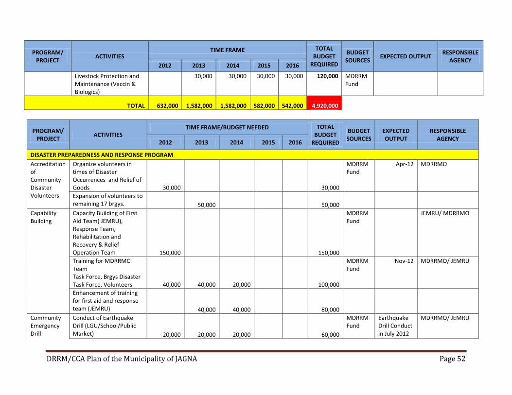
DRRM/CCA Plan of the Municipality of JAGNA Page 52
PROGRAM/ PROJECT
ACTIVITIES TIME FRAME TOTAL
BUDGET REQUIRED
BUDGET SOURCES
EXPECTED OUTPUT RESPONSIBLE
AGENCY 2012 2013 2014 2015 2016
Livestock Protection and Maintenance (Vaccin & Biologics)
30,000 30,000 30,000 30,000 120,000 MDRRM Fund
TOTAL 632,000 1,582,000 1,582,000 582,000 542,000 4,920,000
PROGRAM/ PROJECT
ACTIVITIES TIME FRAME/BUDGET NEEDED TOTAL
BUDGET REQUIRED
BUDGET SOURCES
EXPECTED OUTPUT
RESPONSIBLE AGENCY
2012 2013 2014 2015 2016
DISASTER PREPAREDNESS AND RESPONSE PROGRAM
Accreditation of Community Disaster Volunteers
Organize volunteers in times of Disaster Occurrences and Relief of Goods 30,000 30,000
MDRRM Fund
Apr-12 MDRRMO
Expansion of volunteers to remaining 17 brgys. 50,000 50,000
Capability Building
Capacity Building of First Aid Team( JEMRU), Response Team, Rehabilitation and Recovery & Relief Operation Team 150,000 150,000
MDRRM Fund
JEMRU/ MDRRMO
Training for MDRRMC Team Task Force, Brgys Disaster Task Force, Volunteers 40,000 40,000 20,000 100,000
MDRRM Fund
Nov-12 MDRRMO/ JEMRU
Enhancement of training for first aid and response team (JEMRU) 40,000 40,000 80,000
Community Emergency Drill
Conduct of Earthquake Drill (LGU/School/Public Market) 20,000 20,000 20,000 60,000
MDRRM Fund
Earthquake Drill Conduct in July 2012
MDRRMO/ JEMRU
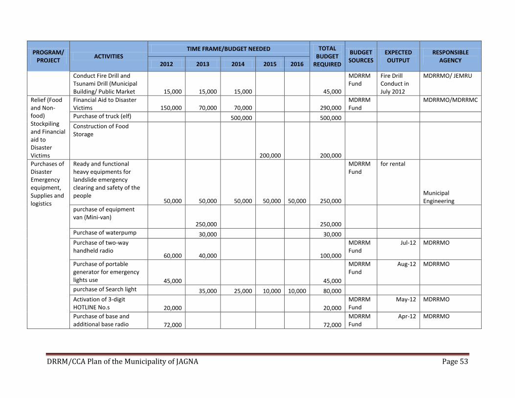
DRRM/CCA Plan of the Municipality of JAGNA Page 53
PROGRAM/ PROJECT
ACTIVITIES TIME FRAME/BUDGET NEEDED TOTAL
BUDGET REQUIRED
BUDGET SOURCES
EXPECTED OUTPUT
RESPONSIBLE AGENCY
2012 2013 2014 2015 2016
Conduct Fire Drill and Tsunami Drill (Municipal Building/ Public Market 15,000 15,000 15,000 45,000
MDRRM Fund
Fire Drill Conduct in July 2012
MDRRMO/ JEMRU
Relief (Food and Non-food) Stockpiling and Financial aid to Disaster Victims
Financial Aid to Disaster Victims 150,000 70,000 70,000 290,000
MDRRM Fund
MDRRMO/MDRRMC
Purchase of truck (elf) 500,000 500,000
Construction of Food Storage
200,000 200,000
Purchases of Disaster Emergency equipment, Supplies and logistics
Ready and functional heavy equipments for landslide emergency clearing and safety of the people
50,000 50,000 50,000 50,000 50,000 250,000
MDRRM Fund
for rental
Municipal Engineering
purchase of equipment van (Mini-van)
250,000 250,000
Purchase of waterpump 30,000 30,000
Purchase of two-way handheld radio
60,000 40,000 100,000
MDRRM Fund
Jul-12 MDRRMO
Purchase of portable generator for emergency lights use 45,000 45,000
MDRRM Fund
Aug-12 MDRRMO
purchase of Search light 35,000 25,000 10,000 10,000 80,000
Activation of 3-digit HOTLINE No.s 20,000 20,000
MDRRM Fund
May-12 MDRRMO
Purchase of base and additional base radio 72,000 72,000
MDRRM Fund
Apr-12 MDRRMO
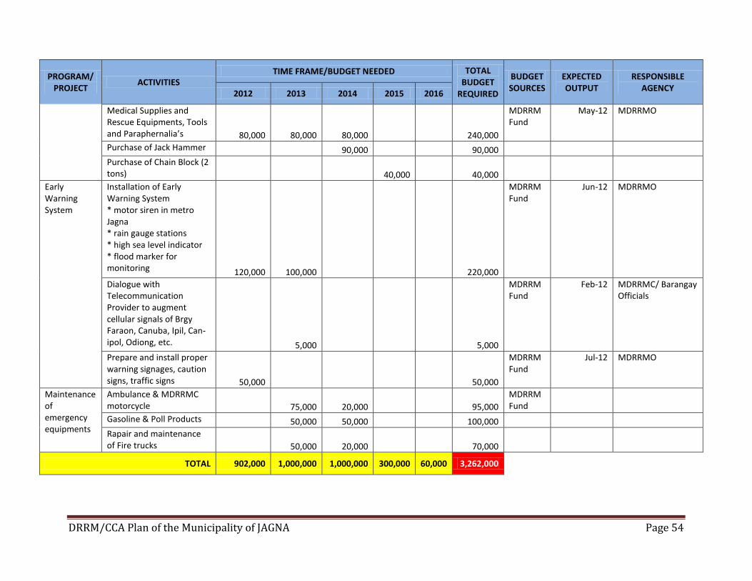
DRRM/CCA Plan of the Municipality of JAGNA Page 54
PROGRAM/ PROJECT
ACTIVITIES TIME FRAME/BUDGET NEEDED TOTAL
BUDGET REQUIRED
BUDGET SOURCES
EXPECTED OUTPUT
RESPONSIBLE AGENCY
2012 2013 2014 2015 2016
Medical Supplies and Rescue Equipments, Tools and Paraphernalia’s 80,000 80,000 80,000 240,000
MDRRM Fund
May-12 MDRRMO
Purchase of Jack Hammer 90,000 90,000
Purchase of Chain Block (2 tons) 40,000 40,000
Early Warning System
Installation of Early Warning System * motor siren in metro Jagna * rain gauge stations * high sea level indicator * flood marker for monitoring 120,000 100,000 220,000
MDRRM Fund
Jun-12 MDRRMO
Dialogue with Telecommunication Provider to augment cellular signals of Brgy Faraon, Canuba, Ipil, Can-ipol, Odiong, etc. 5,000 5,000
MDRRM Fund
Feb-12 MDRRMC/ Barangay Officials
Prepare and install proper warning signages, caution signs, traffic signs 50,000 50,000
MDRRM Fund
Jul-12 MDRRMO
Maintenance of emergency equipments
Ambulance & MDRRMC motorcycle 75,000 20,000 95,000
MDRRM Fund
Gasoline & Poll Products 50,000 50,000 100,000
Rapair and maintenance of Fire trucks 50,000 20,000 70,000
TOTAL 902,000 1,000,000 1,000,000 300,000 60,000 3,262,000
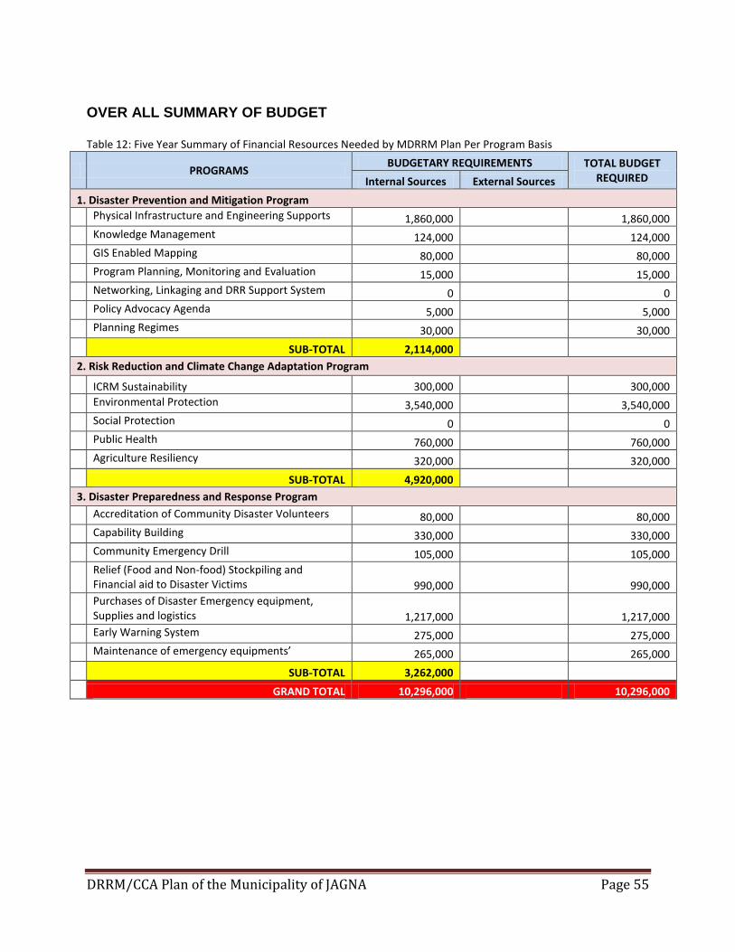
DRRM/CCA Plan of the Municipality of JAGNA Page 55
OVER ALL SUMMARY OF BUDGET
Table 12: Five Year Summary of Financial Resources Needed by MDRRM Plan Per Program Basis
PROGRAMS BUDGETARY REQUIREMENTS TOTAL BUDGET
REQUIRED Internal Sources External Sources
1. Disaster Prevention and Mitigation Program
Physical Infrastructure and Engineering Supports 1,860,000
1,860,000
Knowledge Management 124,000
124,000
GIS Enabled Mapping 80,000
80,000
Program Planning, Monitoring and Evaluation 15,000
15,000
Networking, Linkaging and DRR Support System 0
0
Policy Advocacy Agenda 5,000
5,000
Planning Regimes 30,000
30,000
SUB-TOTAL 2,114,000
2. Risk Reduction and Climate Change Adaptation Program
ICRM Sustainability 300,000
300,000
Environmental Protection 3,540,000
3,540,000
Social Protection 0
0
Public Health 760,000
760,000
Agriculture Resiliency 320,000
320,000
SUB-TOTAL 4,920,000
3. Disaster Preparedness and Response Program
Accreditation of Community Disaster Volunteers 80,000
80,000
Capability Building 330,000
330,000
Community Emergency Drill 105,000
105,000
Relief (Food and Non-food) Stockpiling and Financial aid to Disaster Victims 990,000
990,000
Purchases of Disaster Emergency equipment, Supplies and logistics 1,217,000
1,217,000
Early Warning System 275,000
275,000
Maintenance of emergency equipments’ 265,000
265,000
SUB-TOTAL 3,262,000
GRAND TOTAL 10,296,000 10,296,000

DRRM/CCA Plan of the Municipality of JAGNA Page 56