Embed Size (px)
Citation preview

1 1 F e b r u a r y 2 0 1 6m c G a v o c k H o u s e | P r e L I M I N a r y S P e C I F I C P L a N
m c G a v o c k H o u s e

Purpose Note
The purpose of this plan is to establish the zoning for a mixed-use development and a plan for the reuse of historic structures.
overview of the Location
The corner of Cleveland Street and Meridian Street is the civic and institutional connection of the Cleveland Park and McFerrin Park neighborhoods. Cleveland Street is an important community street that crosses ellington Parkway to connect Dickerson Pike with Gallatin Pike. Neighborhood transit is provided by the Meridian bus line.
This corner is also unique in that it balances civic, institutional, residential and commercial uses. The Nashville Fire Department recently invested in a new firehall. Glenn Elementary sits at the southeast corner. The northeast corner is anchored by the historic Meridian Street Methodist building, most recently home to the ray of Hope Community Church. as seen in the 1908 Sanborn map, the site has long been civic, institutional, residential, and commercial.
In the center of the northwest block is an historic home dating to the 1840s. Ownership of the house was claimed by many important Nashville families - McGavock, Harris, Lindsley - and is significant to the history of Nashville, making it an important part of the Specific Plan zoning. The original structure of the McGa-vock-Harris-Gatewood-Webb House, also know as Fountain blue, was built by James McGavock circa 1840. The house is listed on the National register of Historic Places.
cLeveLaND PaRk
DIc
keRs
oN
PIk
e
1/4 mile radius
mcFeRRIN PaRk
maXWeLL HeIGHTs
HIsToRIc eDGeFIeLD
GReeNWooD
cLeveLaND sTReeT
WesT easTLaND
CONTeXT MaP 1908 SaNbOrN MaP
eLLIN
GTo
N Pa
RkW
aY
INTe
RsTa
Te 2
4To GaLLaTIN PIke
1/2 mile radius
1 mile radius
meRIDIaN Bus (mTa 18)
0 2 / 1 1 / 2 0 1 6© 2 0 1 6
m c G a v o c k H o u s e | O V e r V I e W

community character Policy
The McGavock House Specific Plan site is currently guided by T4 Neighbor-hood Maintenance (T4 NM) and T4 Neighborhood evolving (T4 Ne) policy of the Community Character Manual (CCM).
The site is one parcel removed from T4 Neighborhood Center policy, and that parcel is a civic use. This application seeks to extend the T4 NC policy to the McGavock House SP properties, or utilize a special policy determined by Planning staff through the community planning process.
The McGavock House SP site is in the heart of Cleveland Park, and less than three miles from the heart of Downtown Nashville. Cleveland Street is important connection to transit, services, and jobs on Dickerson road and Gallatin Pike. The Meridian bus line (MTa 28) stops at the corner of Cleveland and Meridian. MTa 28 an unusual neighborhood route that connects residences directly to the jobs and services in Downtown, and Music City Central.
The McGavock House SP site is very near parks and community assets such as Glenn elementary, Cleveland Park and Community Center, McFerrin Park and Community Center, and the Magness-Potter Community Center.
The site includes a historic house (dating to 1840) and open space, a historic church and associated parking, and houses. The site is directly across the street from a fire hall and elementary school and on an important connector street. Just beyond the fire hall and school is a block of commercial zoning and neighbor-hood center policy. This application requests the extension of the neighborhood center policy to include the parcels included in the rezoning. The change in policy will allow uses needed to adaptively reuse the house, church, and open space, all of which are important features in the neighborhood.
both T4 NM and T4 Ne allow missing middle housing such as townhouses within urban neighborhoods. The site is ideally located for the strategic integration of multi-family housing; it is near commercial and civic uses, on a collector street, and on a neighborhood bus line.
The change in policy will allow new construction of multi-family housing. In an established neighborhood of single-family homes, the addition of multi-family housing in a neighborhood center, will provide housing choice in an ideal location – on a connector street and on a transit line.
eaST FaCaDe OF THe MCGaVOCK HOuSe
SaNCTuary eNTraNCeSOuTH FaCaDe OF THe MCGaVOCK HOuSe
THe CHurCH buILDING
0 2 / 1 1 / 2 0 1 6© 2 0 1 6
m c G a v o c k H o u s e | P O L I C y C O M P L I a N C e

Mer
IDIa
N S
Tree
T
CLeVeLaND STreeT
VauGHN STreeT
STO
CKe
LL S
Tree
T
NO
rTH
3rD
STr
eeT
0 2 / 1 1 / 2 0 1 6© 2 0 1 6
m c G a v o c k H o u s e | M a S T e r P L a N
RESUNIT
RESUNIT
RESUNIT RES
UNIT
RESUNIT
NEWACCESSORY
BLDG(3,890 SF
FOOTPRINT)
RESUNIT
RESUNIT
EXISITINGSANCTUARY
4,900 SF
RESUNIT
RESUNIT
RESUNIT
RESUNIT
RESUNIT
RESUNIT
NEWCOMMERCIAL
(1,900 SF)
RESUNIT
EXISTINGADMINISTRATION
BUILDING23,000 SF
RESUNIT
RESUNIT
EXISTINGHOUSE5,000 SF
RESUNIT
RESUNIT
RESUNIT
RESUNIT
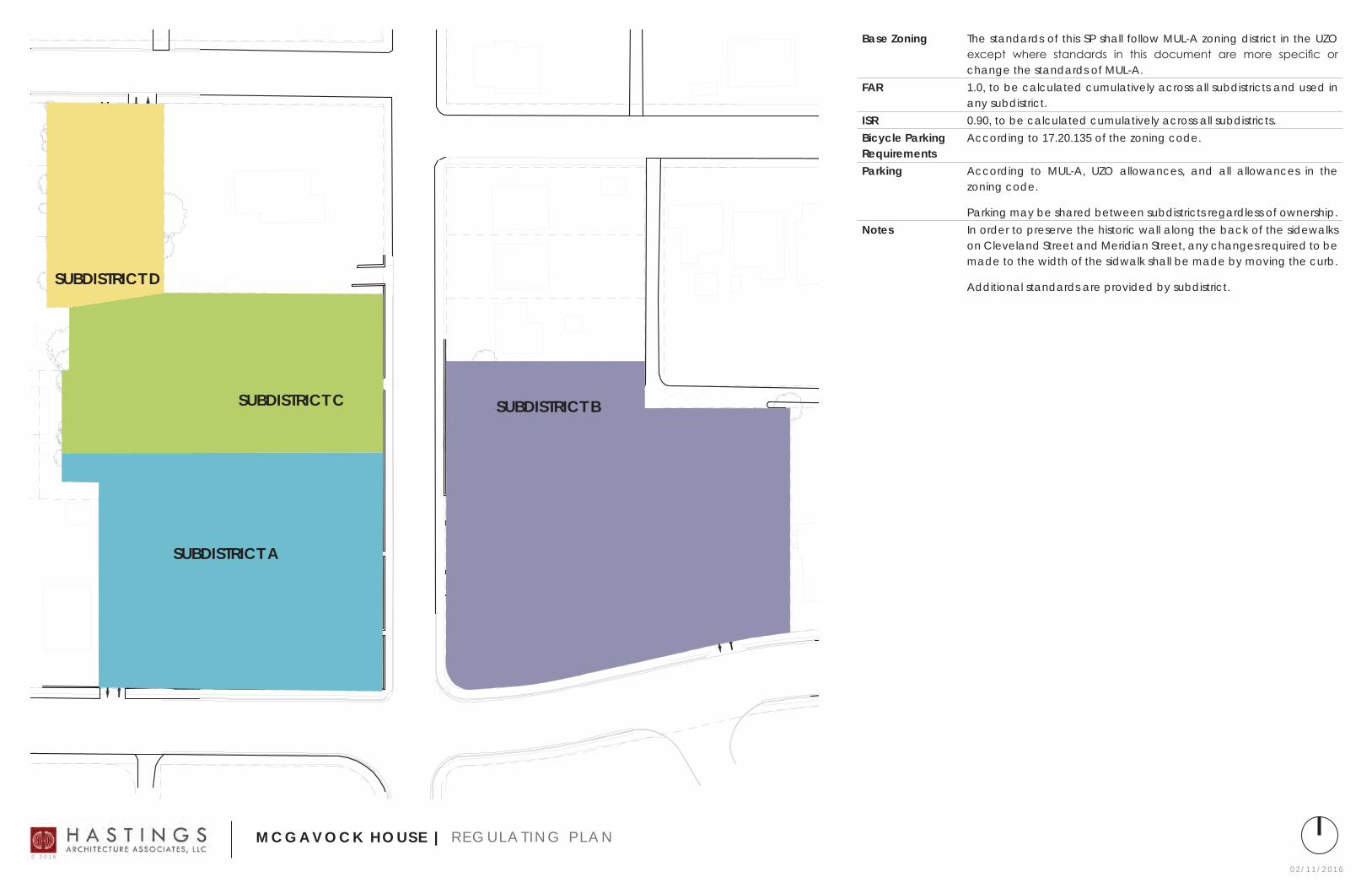
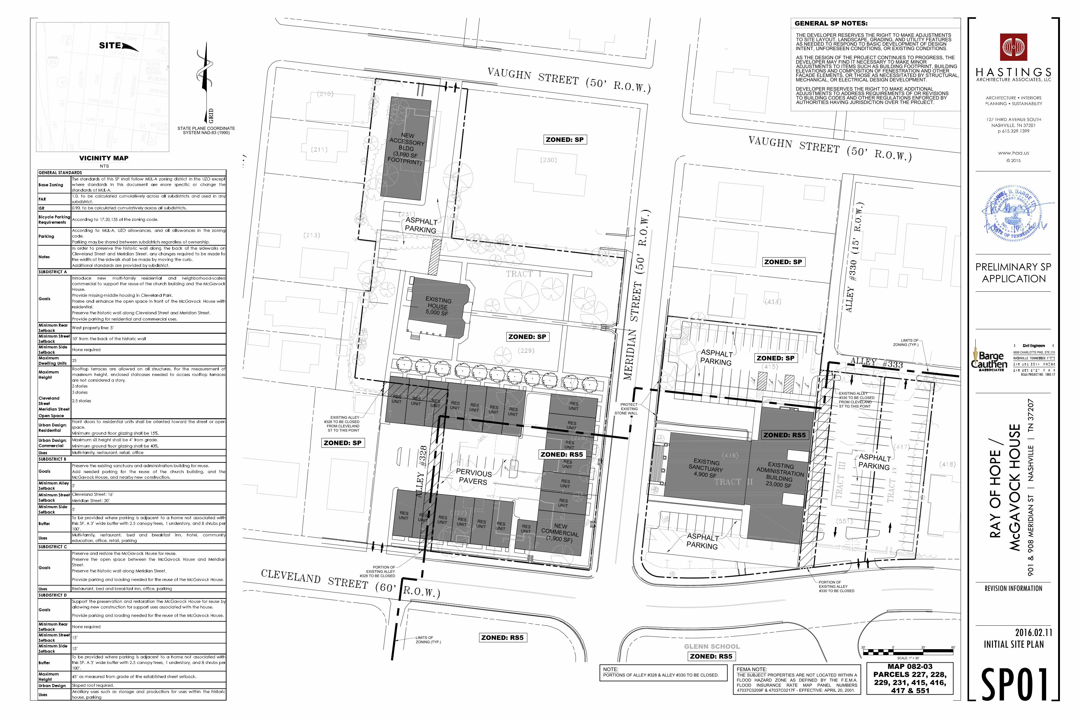
Base Zoning The standards of this SP shall follow MuL-a zoning district in the uZO except where standards in this document are more specific or change the standards of MuL-a.
FaR 1.0, to be calculated cumulatively across all subdistricts and used in any subdistrict.
IsR 0.90, to be calculated cumulatively across all subdistricts.Bicycle Parking Requirements
according to 17.20.135 of the zoning code.
Parking according to MuL-a, uZO allowances, and all allowances in the zoning code.
Parking may be shared between subdistricts regardless of ownership.Notes In order to preserve the historic wall along the back of the sidewalks
on Cleveland Street and Meridian Street, any changes required to be made to the width of the sidwalk shall be made by moving the curb.
additional standards are provided by subdistrict.
suBDIsTRIcT a
suBDIsTRIcT BsuBDIsTRIcT c
suBDIsTRIcT D
0 2 / 1 1 / 2 0 1 6© 2 0 1 6
m c G a v o c k H o u s e | r e G u L a T I N G P L a N

RESUNIT
RESUNIT
RESUNIT RES
UNIT
RESUNIT
NEWACCESSORY
BLDG(3,890 SF
FOOTPRINT)
RESUNIT
RESUNIT
EXISITINGSANCTUARY
4,900 SF
RESUNIT
RESUNIT
RESUNIT
RESUNIT
RESUNIT
RESUNIT
NEWCOMMERCIAL
(1,900 SF)
RESUNIT
EXISTINGADMINISTRATION
BUILDING23,000 SF
RESUNIT
RESUNIT
EXISTINGHOUSE5,000 SF
RESUNIT
RESUNIT
RESUNIT
RESUNIT
Goals Introduce new multi-family residential and neighborhood-scaled commercial to support the reuse of the church building and the McGavock House.
Provide missing-middle housing in Cleveland Park.
Frame and enhance the open space in front of the McGavock House with residential.
Preserve the historic wall along Cleveland Street and Meridian Street.
Provide parking for residential and commercial uses. minimum Rear setback
West property line: 5’
minimum street setback
10’ from the back of the historic wall
minimum side setback
None required
maximum Dwelling units
25
maximum Height
Cleveland Street
Meridian Street
Open Space
rooftop terraces are allowed on all structures. For the measurement of maximum height, enclosed staircases needed to access rooftop terraces are not considered a story.
3 stories
3 stories
2.5 storiesurban Design: Residential
Front doors to residential units shall be oriented toward the street or open space.
Minimum ground floor glazing shall be 15%.urban Design: commercial
Maximum sill height shall be 4’ from grade.
Minimum ground floor glazing shall be 40%.uses Multi-family, restaurant, retail, office
0 2 / 1 1 / 2 0 1 6© 2 0 1 6
m c G a v o c k H o u s e | S u b D I S T r I C T a

RESUNIT
RESUNIT
RESUNIT RES
UNIT
RESUNIT
NEWACCESSORY
BLDG(3,890 SF
FOOTPRINT)
RESUNIT
RESUNIT
EXISITINGSANCTUARY
4,900 SF
RESUNIT
RESUNIT
RESUNIT
RESUNIT
RESUNIT
RESUNIT
NEWCOMMERCIAL
(1,900 SF)
RESUNIT
EXISTINGADMINISTRATION
BUILDING23,000 SF
RESUNIT
RESUNIT
EXISTINGHOUSE5,000 SF
RESUNIT
RESUNIT
RESUNIT
RESUNIT
Goals Preserve the existing sanctuary and administration building for reuse.
add needed parking for the reuse of the church building, and the McGavock House, and nearby new construction.
minimum alley setback
5’
minimum street setback
Cleveland Street: 16’
Meridian Street: 20’minimum side setback
5’
Buffer To be provided where parking is adjacent to a home not associated with this SP. a 3’ wide buffer with 2.5 canopy trees, 1 understory, and 8 shrubs per 100’.
uses Multi-family, restaurant, bed and breakfast inn, hotel, community education, office, retail, parking
0 2 / 1 1 / 2 0 1 6© 2 0 1 6
m c G a v o c k H o u s e | S u b D I S T r I C T b
RESUNIT
RESUNIT
RESUNIT RES
UNIT
RESUNIT
NEWACCESSORY
BLDG(3,890 SF
FOOTPRINT)
RESUNIT
RESUNIT
EXISITINGSANCTUARY
4,900 SF
RESUNIT
RESUNIT
RESUNIT
RESUNIT
RESUNIT
RESUNIT
NEWCOMMERCIAL
(1,900 SF)
RESUNIT
EXISTINGADMINISTRATION
BUILDING23,000 SF
RESUNIT
RESUNIT
EXISTINGHOUSE5,000 SF
RESUNIT
RESUNIT
RESUNIT
RESUNIT
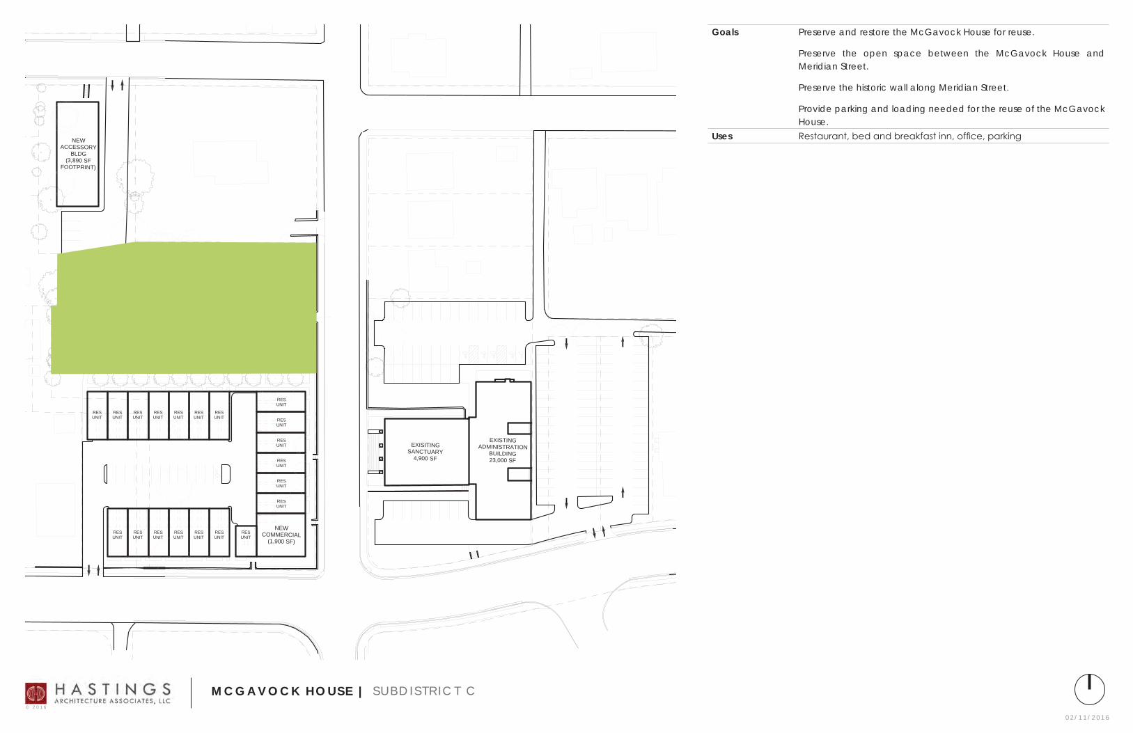
Goals Preserve and restore the McGavock House for reuse.
Preserve the open space between the McGavock House and Meridian Street.
Preserve the historic wall along Meridian Street.
Provide parking and loading needed for the reuse of the McGavock House.
uses Restaurant, bed and breakfast inn, office, parking
0 2 / 1 1 / 2 0 1 6© 2 0 1 6
m c G a v o c k H o u s e | S u b D I S T r I C T C

RESUNIT
RESUNIT
RESUNIT RES
UNIT
RESUNIT
NEWACCESSORY
BLDG(3,890 SF
FOOTPRINT)
RESUNIT
RESUNIT
EXISITINGSANCTUARY
4,900 SF
RESUNIT
RESUNIT
RESUNIT
RESUNIT
RESUNIT
RESUNIT
NEWCOMMERCIAL
(1,900 SF)
RESUNIT
EXISTINGADMINISTRATION
BUILDING23,000 SF
RESUNIT
RESUNIT
EXISTINGHOUSE5,000 SF
RESUNIT
RESUNIT
RESUNIT
RESUNIT
Goals Support the preservation and restoration the McGavock House for reuse by allowing new construction for support uses associated with the house.
Provide parking and loading needed for the reuse of the McGavock House.
minimum Rear setback
None required
minimum street setback
15’
minimum side setback
15’
Buffer To be provided where parking is adjacent to a home not associated with this SP. a 3’ wide buffer with 2.5 canopy trees, 1 understory, and 8 shrubs per 100’.
maximum Height 45’ as measured from grade at the established street setback.urban Design Sloped roof required.uses ancillary uses such as storage and production for uses within the
historic house, parking
0 2 / 1 1 / 2 0 1 6© 2 0 1 6
m c G a v o c k H o u s e | S u b D I S T r I C T D

0 2 / 1 1 / 2 0 1 6© 2 0 1 6
m c G a v o c k H o u s e | S u b D I S T r I C T a : V I e W F r O M C L e V e L a N D S T r e e T

0 2 / 1 1 / 2 0 1 6© 2 0 1 6
m c G a v o c k H o u s e | S u b D I S T r I C T a : V I e W F r O M O P e N S P a C e

0 2 / 1 1 / 2 0 1 6© 2 0 1 6
m c G a v o c k H o u s e | a C C e S S O r y b u I L D I N G : V I e W F r O M V a u G H N S T r e e T
EXISTINGHOUSE
5,000 SF
EXISTINGADMINISTRATIONBUILDING23,000 SF
EXISTINGSANCTUARY4,900 SF
NEWCOMMERCIAL(1,900 SF)
RESUNIT
RESUNIT
RESUNIT
RESUNIT
RESUNIT
RESUNIT
RESUNIT RES
UNIT
RESUNIT
RESUNIT
RESUNIT
RESUNIT
RESUNIT
RESUNIT
RESUNIT
RESUNIT
RESUNIT
RESUNIT
RESUNIT
RESUNIT
NEWACCESSORYBLDG
(3,890 SFFOOTPRINT)
ZONED: RS5GLENN SCHOOL
ZONED: RS5
ZONED: RS5
ZONED: SP
ZONED: SP
ZONED: SP
ZONED: SP
LIMITS OFZONING (TYP.)
ZONED: SP
ASPHALTPARKING
ASPHALTPARKING
ASPHALTPARKING
ASPHALTPARKING
PERVIOUSPAVERS
PROTECTEXISTING
STONE WALL
ZONED: RS5
EXISTING ALLEY#330 TO BE CLOSEDFROM CLEVELANDST TO THIS POINT
EXISTING ALLEY#328 TO BE CLOSED
FROM CLEVELANDST TO THIS POINT
PORTION OFEXISTING ALLEY#330 TO BE CLOSED
PORTION OFEXISTING ALLEY
#328 TO BE CLOSED
LIMITS OFZONING (TYP.)
STATE PLANE COORDINATESYSTEM NAD-83 (1990)
SITE
BC&A PROJECT NO. 1085-17
2016.02.11
PRELIMINARY SPAPPLICATION
RA
Y O
F H
OPE
/
McG
AV
OC
K H
OU
SE
90
1 &
90
8 M
ERID
IAN
ST
|
NA
SH
VIL
LE
|
TN 3
72
07
REVISION INFORMATION
6606 CHARLOTTE PIKE, STE 210
VICINITY MAPNTS
INITIAL SITE PLAN
SP0130' 0' 30' 60'
SCALE: 1" = 30'
FEMA NOTE:THE SUBJECT PROPERTIES ARE NOT LOCATED WITHIN AFLOOD HAZARD ZONE AS DEFINED BY THE F.E.M.A.FLOOD INSURANCE RATE MAP PANEL NUMBERS47037C0209F & 47037C0217F - EFFECTIVE: APRIL 20, 2001.
GENERAL SP NOTES:
AS THE DESIGN OF THE PROJECT CONTINUES TO PROGRESS, THEDEVELOPER MAY FIND IT NECESSARY TO MAKE MINORADJUSTMENTS TO ITEMS SUCH AS BUILDING FOOTPRINT, BUILDINGELEVATIONS AND COMPOSITION OF FENESTRATION AND OTHERFACADE ELEMENTS, OR THOSE AS NECESSITATED BY STRUCTURAL,MECHANICAL, OR ELECTRICAL DESIGN DEVELOPMENT.
DEVELOPER RESERVES THE RIGHT TO MAKE ADDITIONALADJUSTMENTS TO ADDRESS REQUIREMENTS OF OR REVISIONSTO BUILDING CODES AND OTHER REGULATIONS ENFORCED BYAUTHORITIES HAVING JURISDICTION OVER THE PROJECT.
THE DEVELOPER RESERVES THE RIGHT TO MAKE ADJUSTMENTSTO SITE LAYOUT, LANDSCAPE, GRADING, AND UTILITY FEATURESAS NEEDED TO RESPOND TO BASIC DEVELOPMENT OF DESIGNINTENT, UNFORESEEN CONDITIONS, OR EXISTING CONDITIONS.
MAP 082-03PARCELS 227, 228,229, 231, 415, 416,
417 & 551
NOTE:PORTIONS OF ALLEY #328 & ALLEY #330 TO BE CLOSED.

4" TAP
3" D
OM
6" F
IRE
4" D
OM
METER
DDCV
DOMESTICMETER
6" TAP
2" D
OM
2" DOM
RPBP
2" DOM
18" RCP
15" HDPE
15" H
DP
E
15" HDPE
12" HDPE
15" H
DPE
18" R
CP
15" RCP
12" H
DPE
18" RCP
15" H
DPE
EXISTINGHOUSE
5,000 SF
EXISTINGADMINISTRATIONBUILDING23,000 SF
EXISTINGSANCTUARY4,900 SF
NEWCOMMERCIAL(1,900 SF)
RESUNIT
RESUNIT
RESUNIT
RESUNIT
RESUNIT
RESUNIT
RESUNIT RES
UNIT
RESUNIT
RESUNIT
RESUNIT
RESUNIT
RESUNIT
RESUNIT
RESUNIT
RESUNIT
RESUNIT
RESUNIT
RESUNIT
RESUNIT
NEWACCESSORYBLDG
(3,890 SFFOOTPRINT)
GLENN SCHOOL
ASPHALTPARKING
ASPHALTPARKING
ASPHALTPARKING
ASPHALTPARKING
PERVIOUSPAVERS
PROTECTEXISTING
STONE WALL
STATE PLANE COORDINATESYSTEM NAD-83 (1990)
SITE
BC&A PROJECT NO. 1085-17
2016.02.11
PRELIMINARY SPAPPLICATION
RA
Y O
F H
OPE
/
McG
AV
OC
K H
OU
SE
90
1 &
90
8 M
ERID
IAN
ST
|
NA
SH
VIL
LE
|
TN 3
72
07
REVISION INFORMATION
6606 CHARLOTTE PIKE, STE 210
VICINITY MAPNTS
UTILITY PLAN
SP0230' 0' 30' 60'
SCALE: 1" = 30'
FEMA NOTE:THE SUBJECT PROPERTIES ARE NOT LOCATED WITHIN AFLOOD HAZARD ZONE AS DEFINED BY THE F.E.M.A.FLOOD INSURANCE RATE MAP PANEL NUMBERS47037C0209F & 47037C0217F - EFFECTIVE: APRIL 20, 2001.
GENERAL SP NOTES:
AS THE DESIGN OF THE PROJECT CONTINUES TO PROGRESS, THEDEVELOPER MAY FIND IT NECESSARY TO MAKE MINORADJUSTMENTS TO ITEMS SUCH AS BUILDING FOOTPRINT, BUILDINGELEVATIONS AND COMPOSITION OF FENESTRATION AND OTHERFACADE ELEMENTS, OR THOSE AS NECESSITATED BY STRUCTURAL,MECHANICAL, OR ELECTRICAL DESIGN DEVELOPMENT.
DEVELOPER RESERVES THE RIGHT TO MAKE ADDITIONALADJUSTMENTS TO ADDRESS REQUIREMENTS OF OR REVISIONSTO BUILDING CODES AND OTHER REGULATIONS ENFORCED BYAUTHORITIES HAVING JURISDICTION OVER THE PROJECT.
THE DEVELOPER RESERVES THE RIGHT TO MAKE ADJUSTMENTSTO SITE LAYOUT, LANDSCAPE, GRADING, AND UTILITY FEATURESAS NEEDED TO RESPOND TO BASIC DEVELOPMENT OF DESIGNINTENT, UNFORESEEN CONDITIONS, OR EXISTING CONDITIONS.
MAP 082-03PARCELS 227, 228,229, 231, 415, 416,
417 & 551

4" TAP
3" D
OM
6" F
IRE
4" D
OM
METER
DDCV
DOMESTICMETER
6" TAP
2" D
OM
2" DOM
RPBP
2" DOM
18" RCP
15" HDPE
15" H
DP
E
15" HDPE
12" HDPE
15" H
DPE
18" R
CP
15" RCP
12" H
DPE
18" RCP
15" H
DPE
EXISTINGHOUSE
5,000 SF
EXISTINGADMINISTRATIONBUILDING23,000 SF
EXISTINGSANCTUARY4,900 SF
NEWCOMMERCIAL(1,900 SF)
RESUNIT
RESUNIT
RESUNIT
RESUNIT
RESUNIT
RESUNIT
RESUNIT RES
UNIT
RESUNIT
RESUNIT
RESUNIT
RESUNIT
RESUNIT
RESUNIT
RESUNIT
RESUNIT
RESUNIT
RESUNIT
RESUNIT
RESUNIT
NEWACCESSORYBLDG
(3,890 SFFOOTPRINT)
GLENN SCHOOL
TIE INTO EXISTINGSTOMR MANHOLE
PROPOSED BIORETENTION
PROPOSED BIORETENTION
PRO
POSE
D B
IOR
ETEN
TIO
N
BIORETENTION
TIE INTO EXISTINGSTOMR MANHOLE
ASPHALTPARKING
ASPHALTPARKING
ASPHALTPARKING
ASPHALTPARKING
PERVIOUSPAVERS
OVERFLOWDISCHARGE &
UNDERDRAINSTO TIE INTO
EXISTING ROOFDRAIN SYSTEM
URBANBIORETENTION(TYP. OF ALLPLANTERS)
BIORETENTIONWITH UNDERDRAINSYSTEM
PROTECTEXISTING
STONE WALL
K-GRATE
K-GRATE
6" PERFORATEDUNDERDRAIN (TYP.)
SP03
STATE PLANE COORDINATESYSTEM NAD-83 (1990)
SITE
BC&A PROJECT NO. 1085-17
2016.02.11
PRELIMINARY SPAPPLICATION
RA
Y O
F H
OPE
/
McG
AV
OC
K H
OU
SE
90
1 &
90
8 M
ERID
IAN
ST
|
NA
SH
VIL
LE
|
TN 3
72
07
REVISION INFORMATION
6606 CHARLOTTE PIKE, STE 210
VICINITY MAPNTS
STORMWATER
MANAGEMENT PLAN
30' 0' 30' 60'
SCALE: 1" = 30'
FEMA NOTE:THE SUBJECT PROPERTIES ARE NOT LOCATED WITHIN AFLOOD HAZARD ZONE AS DEFINED BY THE F.E.M.A.FLOOD INSURANCE RATE MAP PANEL NUMBERS47037C0209F & 47037C0217F - EFFECTIVE: APRIL 20, 2001.
GENERAL SP NOTES:
AS THE DESIGN OF THE PROJECT CONTINUES TO PROGRESS, THEDEVELOPER MAY FIND IT NECESSARY TO MAKE MINORADJUSTMENTS TO ITEMS SUCH AS BUILDING FOOTPRINT, BUILDINGELEVATIONS AND COMPOSITION OF FENESTRATION AND OTHERFACADE ELEMENTS, OR THOSE AS NECESSITATED BY STRUCTURAL,MECHANICAL, OR ELECTRICAL DESIGN DEVELOPMENT.
DEVELOPER RESERVES THE RIGHT TO MAKE ADDITIONALADJUSTMENTS TO ADDRESS REQUIREMENTS OF OR REVISIONSTO BUILDING CODES AND OTHER REGULATIONS ENFORCED BYAUTHORITIES HAVING JURISDICTION OVER THE PROJECT.
THE DEVELOPER RESERVES THE RIGHT TO MAKE ADJUSTMENTSTO SITE LAYOUT, LANDSCAPE, GRADING, AND UTILITY FEATURESAS NEEDED TO RESPOND TO BASIC DEVELOPMENT OF DESIGNINTENT, UNFORESEEN CONDITIONS, OR EXISTING CONDITIONS.
STORMWATER NOTES:
PLAN NOTES:
1. 78-840 NOTE: ANY EXCAVATION, FILL, OR DISTURBANCE OF THE EXISTING GROUND ELEVATION MUST BE DONE IN ACCORDANCE WITH STORM WATER MANAGEMENT ORDINANCE NO. 78/840 AND APPROVED BY THE METROPOLITAN DEPARTMENT OF WATER SERVICES.)
2. METRO WATER SERVICES SHALL BE PROVIDED SUFFICIENT AND UNENCUMBERED ACCESS IN ORDER TO MAINTAIN AND REPAIR UTILITIES IN THIS SITE.
3. THE REQUIREMENTS OF THE METRO FIRE MARSHAL'S OFFICE FOR EMERGENCY VEHICLE ACCESS AND ADEQUATE WATER SUPPLY FOR FIRE PROTECTION MUST BE MET PRIOR TO THE ISSUANCE OF ANY BUILDING PERMITS.
4. FOR ANY DEVELOPMENT STANDARDS, REGULATIONS, AND REQUIREMENTS SPECIFICALLY NOT SHOWN ON THE SP PLAN AND/OR INCLUDED AS A CONDITION OF COMMISSION OR COUNCIL APPROVAL, THE PROPERTY SHALL BE SUBJECT TO THE STANDARDS OF MUG ZONING DISTRICT AS OF THE DATE OF THE APPLICABLE REQUEST OR APPLICATION.
5. THE DEVELOPER'S FINAL CONSTRUCTION DRAWINGS SHALL COMPLY WITH THE DESIGN REGULATIONS ESTABLISHED BY THE DEPARTMENT OF PUBLIC WORKS. FINAL DESIGN MAY VARY BASED ON FIELD CONDITIONS.
6. NO STEPS ARE TO BE LOCATEDWITHIN RIGHT OF WAY.
1. THIS DRAWING IS FOR ILLUSTRATION PURPOSES TO INDICATE THE BASIC PREMISE OF THE DEVELOPMENT. THE FINAL LOT COUNT AND THE DETAILS OF THE PLAN SHALL BE GOVERNED BY THE APPROPRIATE REGULATIONS AT THE TIME OF FINAL APPLICATION.
MAP 082-03PARCELS 227, 228,229, 231, 415, 416,
417 & 551
NOTE:PORTIONS OF ALLEY #328 & ALLEY #330 TO BE CLOSED.
![024 024 024 024 024 024 024 024 024 024 024 024 024 024 ... · V 030f-~ 034y. \" _4:3 1 E E 030 3 I "'~-='\»¥_.;. 030-:"'* 7 030 E]uzmPLATE-CHARCOAL FINISH EEIZ PRECAST concnm-mwxmcuancousum](https://img.pdfslide.us/doc/110x75/5f5b5133881fc8234a1a6813/024-024-024-024-024-024-024-024-024-024-024-024-024-024-v-030f-034y-.jpg)