Embed Size (px)
Citation preview

2014-09-04, Hier ggf. Veranstaltungstage oder Autor oder beides © 2016 UNIVERSITY OF ROSTOCK | Baltic TRANSCOAST
Marine and terrestrial influence on submarine groundwater
discharge in coastal waters connected to a peatland
Miriam Ibenthal Rostock University
Supervised by M. Janssen, B. Lennartz (Rostock),
G. Massmann (Oldenburg), T. Ptak (Göttingen)

2014-09-04, Hier ggf. Veranstaltungstage oder Autor oder beides © 2016 UNIVERSITY OF ROSTOCK | Baltic TRANSCOAST
DFG - Research Training Group - Baltic TRANSCOAST
Hydrodynamics
Geochemistry
Biology
Rostock
Autumn school in Askö field station, Sweden
Understanding coastal interactions:

2014-09-04, Hier ggf. Veranstaltungstage oder Autor oder beides © 2016 UNIVERSITY OF ROSTOCK | Baltic TRANSCOAST
Submarine groundwater discharge (SGD)
SGD driven by:
• Hydraulic gradient
• Density gradient
• Thermal gradient
• Storm
• Waves
• Tides
Seawater mixing with freshwater can lead to desorption of ions, oxidation of organic carbon and
release of nutrients.

2014-09-04, Hier ggf. Veranstaltungstage oder Autor oder beides © 2016 UNIVERSITY OF ROSTOCK | Baltic TRANSCOAST
Importance of Peatlands – What is Peat?
• Porosity: ~90%, decreases with depth
• Drainage: compaction of peat, release of CO2
• Partly degraded plant material
• Growth under anaerobic conditions
• Carbon sink and methane production
Ecohydrology Research Group
Waterloo University, F. Rezanezhad
Back-scattered electron image of a
Sphagnum peat
1 cm
HNE Eberswalde
Phragmite peat
Peat with wood from Hütelmoor
(partly degraded)

2014-09-04, Hier ggf. Veranstaltungstage oder Autor oder beides © 2016 UNIVERSITY OF ROSTOCK | Baltic TRANSCOAST
Importance of Peatlands
Drösler und Freibauer, 2012
• Globally: storage of 10% of freshwater and 30% of land-based organic carbon
• 13% of land area in MV is peatland
• >90% of peatlands in MV are being drained → 25% of total emissions of the state
Lappalainen, 1996
MV (Mecklenburg-
Vorpommern)
Bog
Fen
2014-09-04, Hier ggf. Veranstaltungstage oder Autor oder beides © 2016 UNIVERSITY OF ROSTOCK | Baltic TRANSCOAST
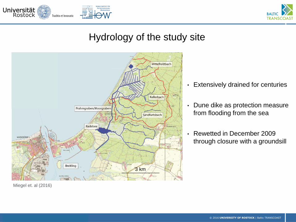
Hydrology of the study site
Miegel et. al (2016)
• Extensively drained for centuries
• Dune dike as protection measure
from flooding from the sea
• Rewetted in December 2009
through closure with a groundsill
3 km

2014-09-04, Hier ggf. Veranstaltungstage oder Autor oder beides © 2016 UNIVERSITY OF ROSTOCK | Baltic TRANSCOAST
Tiepolt, July 2016
Study site Heiligensee und Hütelmoor

2014-09-04, Hier ggf. Veranstaltungstage oder Autor oder beides © 2016 UNIVERSITY OF ROSTOCK | Baltic TRANSCOAST
CH4 CO2 measurements
Frozen methane bubbles
Ks measurements
L. Gosch N. Geißler
What is happening on land?

2014-09-04, Hier ggf. Veranstaltungstage oder Autor oder beides © 2016 UNIVERSITY OF ROSTOCK | Baltic TRANSCOAST
Benthic chamber
H. Schade
Pore water sampling along the beach
J. Westphal
Core sampling to measure N20 and CH4
What is happening in the sea?

2014-09-04, Hier ggf. Veranstaltungstage oder Autor oder beides © 2016 UNIVERSITY OF ROSTOCK | Baltic TRANSCOAST
Objectives
Hypothesis: SGD varies spatially (geology) and temporally (event driven),
and interface is in a transient state (long-term)
→ Understand the driving forces for groundwater flow in the peatland
• Influence of drainage channels, heterogeneity of peat
→ Exchange processes at interface land-sea:
• SGD or saltwater intrusion (spatial and temporal distribution)
• Geology: Influence of (less permeable) peat layer and varying thickness of aquifer
→ Base for later studies on quantification of nutrient load

2014-09-04, Hier ggf. Veranstaltungstage oder Autor oder beides © 2016 UNIVERSITY OF ROSTOCK | Baltic TRANSCOAST
Groundwater flow
• Water level readings
• Drilling for geological characterisation
• Determination of K with slug test and grain size analysis
• Density-dependent transient GW flow model
Groundwater quality:
• Electrical conductivity readings
• GW age dating: 3H/He method
• GW chemistry: major ions
Overview Methods
Well installation
Slug test „Boreas“ drilling platform

2014-09-04, Hier ggf. Veranstaltungstage oder Autor oder beides © 2016 UNIVERSITY OF ROSTOCK | Baltic TRANSCOAST
Drilling and installation of observation wells
• 17 wells (3 in ditches), 1 to 6 m deep, in winter 16/17
• Loggers measure EC and water level (pressure) every 15 minutes
1 m

2014-09-04, Hier ggf. Veranstaltungstage oder Autor oder beides © 2016 UNIVERSITY OF ROSTOCK | Baltic TRANSCOAST
Profile Hütelmoor: Filter depths and K-values
Kr from Slug-Tests in m/sec
1.9E-05 1.8E-05
2.3E-05
1.5E-05 peat
aquifer
till

2014-09-04, Hier ggf. Veranstaltungstage oder Autor oder beides © 2016 UNIVERSITY OF ROSTOCK | Baltic TRANSCOAST
Water levels across Forest – Hütelmoor – Beach
Baltic
Forest
2LS dune
Peatland:7LS 7P 6LS

2014-09-04, Hier ggf. Veranstaltungstage oder Autor oder beides © 2016 UNIVERSITY OF ROSTOCK | Baltic TRANSCOAST
Groundwater ages (J. Sültenfuß)
95% older than 1950
2/3 older than 1950 Infiltration 2010
1/4 older than 1950
30 years

2014-09-04, Hier ggf. Veranstaltungstage oder Autor oder beides © 2016 UNIVERSITY OF ROSTOCK | Baltic TRANSCOAST
Electrical conductivity distribution
~0.6 ~ 8
~9.5 ~8
~7
5.0
6.4
~1.3
3-8
~12
Front of Heiligensee
EC in mS/cm
EC Baltic: ~20

2014-09-04, Hier ggf. Veranstaltungstage oder Autor oder beides © 2016 UNIVERSITY OF ROSTOCK | Baltic TRANSCOAST
Profile along beach

2014-09-04, Hier ggf. Veranstaltungstage oder Autor oder beides © 2016 UNIVERSITY OF ROSTOCK | Baltic TRANSCOAST
Salinity in permanent pore water lances (J. Westphal, IOW)
43 61

2014-09-04, Hier ggf. Veranstaltungstage oder Autor oder beides © 2016 UNIVERSITY OF ROSTOCK | Baltic TRANSCOAST
3-D conceptual model
Peat 1E-07
Based on 168 drillings from
literature and own work:
• 33 deeper drillings
• 71 peat cores
• 64 peat probings
Steady state simulation with
Visual Modflow Flex
K [m/s]

2014-09-04, Hier ggf. Veranstaltungstage oder Autor oder beides © 2016 UNIVERSITY OF ROSTOCK | Baltic TRANSCOAST
Testing the influence of drainage channels: Boundary conditions
Fo
rest
BC
Observation heads

2014-09-04, Hier ggf. Veranstaltungstage oder Autor oder beides © 2016 UNIVERSITY OF ROSTOCK | Baltic TRANSCOAST
Testing the influence of drainage channels: Head contour lines [m]
No ditches With ditches
2.5
m
2.5
m
Connectivity of ditches with aquifer?

2014-09-04, Hier ggf. Veranstaltungstage oder Autor oder beides © 2016 UNIVERSITY OF ROSTOCK | Baltic TRANSCOAST
• Drainage channels influence the groundwater
flow regime and the resulting hydraulic gradient.
• The hydraulic gradient further depends on dry
or wet periods, stormy winters with periodically
higher sea levels and the interaction of these
states.
• Electrical conductivity measurements show
heterogeneous distribution:
• Interface: complex mixing processes
due to geology and dune dike width.
• Peatland: peat structure and ditches.
Summary

2014-09-04, Hier ggf. Veranstaltungstage oder Autor oder beides © 2016 UNIVERSITY OF ROSTOCK | Baltic TRANSCOAST
Outlook
• Calibration of the model (steady state and later transient) within the peatland
• Connectivity of ditches with the aquifer
• GW flow in the peat: problem of heterogeneity (K peat)
• Extend the model to the seaside and include density transport (SEAWAT)
• Calibration of density-transport crucial: Transient interface due to drainage
• Scenario simulation: long-term drainage, rewetting, sea-level rise...
• Model helps to determine which factors lead to
SGD / saltwater intrusion
• Quantify amount of fresh and re-circulating SGD
Thank you
2014-09-04, Hier ggf. Veranstaltungstage oder Autor oder beides © 2016 UNIVERSITY OF ROSTOCK | Baltic TRANSCOAST
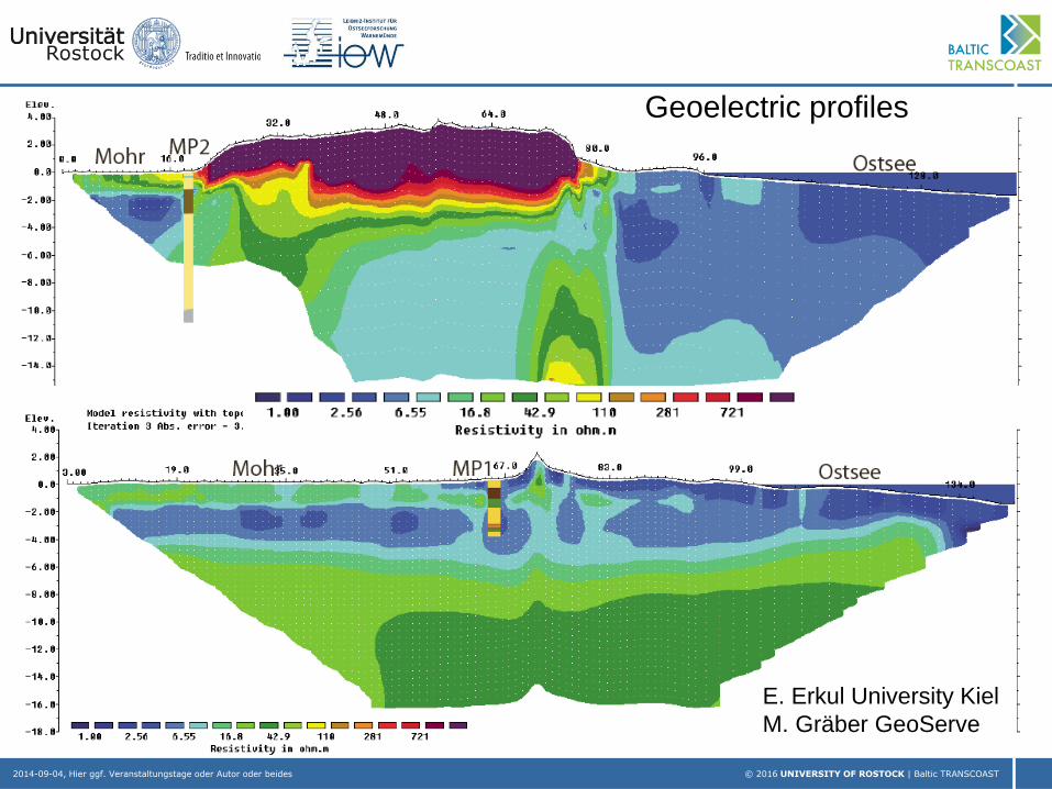
Geoelectric profiles
E. Erkul University Kiel
M. Gräber GeoServe

2014-09-04, Hier ggf. Veranstaltungstage oder Autor oder beides © 2016 UNIVERSITY OF ROSTOCK | Baltic TRANSCOAST
• Anthropogenic interferences as drainage channels influence the groundwater flow
regime and the resulting hydraulic gradient. The hydraulic gradient further depends on
dry or wet periods, stormy winters with periodically higher sea levels and the
interaction of these states.
• Electrical conductivity measurements show heterogeneous distribution: complex
mixing processes at the interface due to geology and dune dike width.
• The groundwater flow model will be further extended to the seaside to consider the
outcropping peat layer. Density-dependent flow will be implemented to simulate mixing
processes at the interface.
• The groundwater flow model will help to understand:
• Which factors (varying extend of geological layers at the interface, hydraulic gradient)
drive submarine groundwater discharge
• Hypothesis of a transient interface: How was the fresh- saltwater interface influenced
by long-term drainage (e.g. reversed hydraulic gradient landwards, hence saltwater
intrusion), how fast is it changing under rewetted conditions (higher hydraulic gradient
seaward)?

2014-09-04, Hier ggf. Veranstaltungstage oder Autor oder beides © 2016 UNIVERSITY OF ROSTOCK | Baltic TRANSCOAST
Comparison of simulated and observed heads
• Linear interpolation of BC Forest
• Nearby ditches not considered
• Density not yet considered
• Homogeneous K within the aquifer
Missing:
Water level measurements in main ditches
Discharge of the area

2014-09-04, Hier ggf. Veranstaltungstage oder Autor oder beides © 2016 UNIVERSITY OF ROSTOCK | Baltic TRANSCOAST
Baltic Sea
Water depth and salinity distribution
Ulf Gräwe, IOW

2014-09-04, Hier ggf. Veranstaltungstage oder Autor oder beides © 2016 UNIVERSITY OF ROSTOCK | Baltic TRANSCOAST
Importance of Submarine Groundwater Discharge
• Lost freshwater resource
• Nutrient and contaminant transport

2014-09-04, Hier ggf. Veranstaltungstage oder Autor oder beides © 2016 UNIVERSITY OF ROSTOCK | Baltic TRANSCOAST
Groundwater ages Hütelmoor
>1950
55 years average
2/3 >1950 Infiltration 2010
1/4 >1950
30 years

2014-09-04, Hier ggf. Veranstaltungstage oder Autor oder beides © 2016 UNIVERSITY OF ROSTOCK | Baltic TRANSCOAST
Field work
Outcropping peat
Well installation
„Boreas“ drilling platform
Slug test