Embed Size (px)
Citation preview
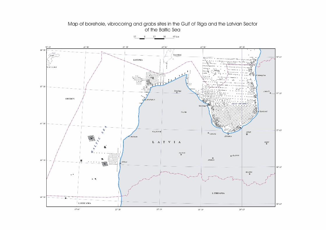
MARINE AND COASTAL GEOLOGY IN LATVIAN SECTOR OF THE BALTIC
SEA: SHORT REVIEW
G. Konshin, V. Seglins, I. Nulle
“The Baltic Sea Geology - 10” 24-28 August 2010, St.P etersburg, Russia
Introduction• A high level of knowledge regarding its geology charac terizes
the Latvian offshore and coastal zone. The most part of available data and information on marine and coastal areas has been received during till 1991 as a result of systemat ic geological surveying, prospecting and scientific inve stigations.
• At this time the Latvian geological archives have co llected a lot of geological reports, unpublished maps, cores and s amples of bottom sediments, seismic and acoustic data from th e Baltic Sea.
• Each national organization has published the results of their research in the scientific literature and some have pu blished maps showing the distribution of sediments on the se abed and below seabed. Much scientific work has been publish ed in the proceedings “Marine geology and geophysics” released b y institute VNIIMorgeo.
Following activities
• After 1991 field geological works in the Baltic Sea had not great value. Exception was a joint Swedish-Lithuanian-Latvian geophysical expedition (1993 – 1998), during which seismoacoustic and sonar investigations were conducted in the Latvian sector of the central Baltic Sea.
• The main spheres of marine geological activities at present are collection, processing and dissemination of information, coastal monitoring and participating in international projects on marine geology and geophysics.

Information resources on marine geology and geophysics
• Seabed mapping
Scheme of the Baltic Sea, showing coverage of unpublished
map areas within the Latvian territorial waters at the scale 1:200 000
The Latvia territorial waters and Exclusive Economic Zone (EEZ) has regarding to the geology been mapped in detail (scale 1:200 000) and in a reconnaissance scale (1:500 000,
1:1 000 000). As a result of mapping, a set of
unpublished maps was prepared, including: • Bottom sediment map, • Map of Quaternary deposits, • Bedrock map, • Map of mineral resources, • Geomorphologic map, • Landscape - ecological map, • Map of pre- Quaternary relief and some more.

Published maps, scale 1: 200 000
• In 1997, in co-operation with the Geological Survey of Estonia, maps at the scale 1:200 000 were published: The Gulf of Riga seabed pre-Quaternary and Quaternary deposits, landscape–ecological map and Map of bottom sediments.
• There is an accompanying explanatory note in English; the legend is in Latvian, Estonian and English. These materials can be used for the planning of economic activities, in particular, in development of shipping and fisheries.

Simplified map by Baltic Sea Institute Germany, based on geological mapping results

Coverage of newpublished geological map areas
• The maps are based on the accurate topographic base - the Latvian Co-ordinate System (LKS–92 ).
• Each map is accompanied by descriptions of the geological structure in Latvian and short explanatory notes in English.
• Geological maps of pre-Quaternary and Quaternary deposits at the scale 1:200 000, several auxiliary maps at the scale 1:500 000 and descriptions of the geological structure provide information about the rocks in the area, conditions of their occurrence, minerals, relief structure and modern geological processes.
For details see: www.meteo.lv
Published reconnaissance maps, scale 1:500 000, 1:1 000 000
• Within the framework of a joint project (GEOBALT ), two maps at a scale of 1:500,000 showing the bathymetry (Gelumbauskaite, 1998) and the seabed sediments (Repecka & Cato, 1998) of the central Baltic Sea, respectively, were published in 1998 accompanied by a subsidiary description (Gelumbauskaite et al., 1999).

Marine sand and gravel resources in Latvia
• During 1975 - 1992, at the costal zone of the Gulf of Riga and Baltic Sea proper, in the area from Cape Ovishito Pavilosta, prospecting and exploration for construction sand sand-gravel mix and titanium-zirconium placers were carried out. The operations incorporated the coastal zone to the depth 30 m.
• A forecast of the impact of mining on the condition of the coast and benthos was made. It should be mentioned that, at the western and southern coastal slope of the Gulf of Riga, several sand occurrence areas were discovered. Their are not large, the sand layer there is thin, that is why sand extraction in the Gulf of Riga is not planned in the near future. It is also necessary to preserve that area as a fish spawning ground.

Coverage of sandand gravel resources within the Latvian territorial
waters
Potential marine oil resources in Latvia
• Territory of Latvia is a part of the so-called Baltic Syneclise and the Latvian Saddle, located on the north-western edge of the East European Platform.
• The Latvian hydrocarbon prospects are associated with Western Latvia and the adjacent part of the Baltic Sea shelf, i.e. the northern part of the Baltic Syneclise.
• The Baltic Syneclise is a sedimentary basin with thick succession of sedimentary rocks and is regarded as highly prospective, being part of a proven, Baltic petroliferous province, with oil production in several countries. In total about 35 hydrocarbon accumulations have been discovered there. Most of them are oil accumulations, but offshore Poland gas pools were also found.
• In Latvia, several small oil accumulations were discovered from 1967, and there was no exploration activity during the last 10 years. Only minor, short time oil production took place during the crisis time in 1990.
• In March 27, 2009, the Ministry of Economics has announced a licensing competition for exploration and production in the southwest part of the Latvian offshore in the Baltic Sea.

Coastal Geology• Latvian Coastal Zone is characterized by a high lev el
of knowledge regarding it geology and geomorphology. General description of sea coast, transport of the sandy material under the influence of waves and currents, features of various types of economic activities under complex coastal conditions are generalized in the monograph Latvian Coastal zone of Baltic sea, 1998 and shown in the map General Lithological and Geomorphological map of Latvia shore zone - Baltic Sea and Gulf of Riga. 1:200 000 V.Ulsts, L.Bulgakova (ed. I.Veinbergs, V.Juskevics), 1998.
• There are more recent published monographs regarding coastal processes and erosion forecasts a t Latvia coast evaluated by G. Eberhards.

Databases• The Latvian geological archives have collected a lot of geological
reports, unpublished maps, cores and samples of bottom sediments, seismic and acoustic data.
• For generalization and storage of the geological information regarding to the Latvian sector of the Baltic Sea major data arestored in electronic archives – PC data bases.
• Latgeo• Boreholes • Geonafta• Gulf of Riga • “Rīgas jūras līcis”• Geofbank• Euroseismic Latvia

Participation of Latvia in international projects
on marine geology and geophysics• The accession of Latvia in the EU meant the
start of the participation of Latvian geologists in international projects aimed at the provision of a high degree of compatibility, accessibility and interchange ability in marine geological data and information.
• From 1998 to 2004, with the support of the European Commission, three interrelated scientific projects: Eumarsin (European Marine Sediment Information Network), Eurocore (A Searchable Internet Database of Seabed Samples from the Ocean Basins held at European Institutions) and Euroseimic (European Marine Seismic Metadata and Information Centre) have implemented. As a result of those projects, the powerful GIS-based meta-database EU-SEASED on European seafloor was established in the Internet (http://www.eu-seased.net).
• However, during the Eumarsin and Eurocoreprojects, only metadata on samples held within the western European countries were submitted to the EU-SEASED database. Metadata on seafloor samples held by the Latvia and other New Accession States (NAS) of Eastern Europe were not included.
Metadata search in Euroseismic
Current activities
• In 2003, during the implementation of the Euroseimic Project, a test evaluation of the possibility of the Latvian participation in the Seiscan Programme took place. Programmedeals with the scanning of seismic records stored on paper and their transformation into the digital SEG-Y format for further processing.
• The scanning of 500 seismic records using the wide-band scanner was recognised as complying with the requirements of Seiscan. It is planned to renew these activities within the GEoSeas project.
Activities II
• In 2005, the geologists of LEGMA participated in the preparation of the national section of Seabed sediment (Resources) mapping programme of ICES (International Council for the Exploration of the Sea). The aim of this programme is to present the methods and results of various geological (sub) seabed mapping programmes that may lead to insight in the occurrence of aggregate resources

Activities III• In 2009, Latvia started to implement two
new International projects: Geo-Seas and EmodNet .
• International Project Geo-Seas, initiated within the framework of FP7, aims to create a Pan-European infrastructure of twenty-five data centres in seventeen European coastal countries for management of marine and ocean geological and geophysical data.
See in details: http://www.geo-seas.eu/

Current activities IV
• The main target of the Geo-Seas and EmodNet projects is to significantly improve access to marine geological and geophysical data that are stored in the Geological Surveys and Research institutes in Europe, by upgrading their current infrastructure based on infrastructure SeaDataNet (http://seadatanet.org).
• The overall objective of the Geo-Seas project is to effect a major and significant improvement in the overview and access to marine geological and geophysical data and data-products from national geological surveys and research institutes in Europe by upgrading and interconnecting their present infrastructures on basis SeaDataNet infrastructure.
European Marine Observation and Data Network (EMODN ET), see in details: http://ec.europa.eu/maritimeaffairs/emodnet_en.html #1
“OneGeology-Europe”Currently these are data collection and dissemination
activities within the number of particular projects. Activities will deliver: – specifications for interoperable geology spatial dataset at 1:1
million for all the seas under consideration;– information layers for sea-bed sediments, sea-floor geology,
coastal erosion and sedimentation; – the geological data layers will be delivered through the Web
using the ‘OneGeology’ portal; – a robust OneGeology-Europe project compliant data model,
schema mark-up language; – web portal providing multilingual access to the data; – best practice examples of the delivery of geological data to a
range of users; – exchange of science, informatics and business skills across the
EU and globally.
In details see: http://www.onegeology-europe.org/
Thank you for attention!