Embed Size (px)
Citation preview
..
REPRINTED FROM:
Records of the Geological Survey of New South Wales
Volume 17, Part 1, pp. 41-52
COASTAL GEOLOGY OF THE CUDGEN AREA, NORTH COAST OF NEW SOUTH WALES
ByP. S. ROY
DEPARTMENT OF MINES NEW SOUTH WALES
1975
COASTAL GEOLOGY OF THE CUDGEN AREA, NORTH COAST OF NEW SOUTH WALES
ByP. S. ROY
(Manuscript dated September 1973)
ABsTRACT
The results of a geological investigation of the coastal plain and interbarrier creeks in the Cudgen area of the northern New South Wales coast are described. The coastline has accreted to a mature stage of development but is potentially vulnerable to coastal erosion. The lower reaches of Cudgen Creek have silted up in recent times mainly due to wind erosion of adjacent dunes mined for heavy minerals. Dune rehabilitation, bank stabilization, channel dredging, and meander straightening are measures recommended for the improvement of Cudgen Creek. Flooding of a development site on the side of Cudgen Lake is attributed to inadequate design rather than to changes in the lake's regime. The development of canal estates in a non-tidal environment is considered undesirable.
INTRODUCfION
Periodic flooding of low-lying coastal areas between Kingscliff and Brunswick Heads on the North Coast of New South Wales has, in recent years, caused increasing problems in the Tweed Shire, and flood-mitigation measures are advocated by many residents in the areas affected . In assessing the problem and formulating a flood-mitigation proposal Tweed Shire Council requested a geological inspection of Cudgen Creek and Lake and Cudgera and Mooball Creeks which are the main drainage systems in the area. The Cudgen Creek and Lake system is the major trouble area.
A field inspection was undertaken in July 1973 by members of the Marine Geology Section of the Geological Survey of New South Wales, and the results are reported below.
FORMULATION OF THE PROBLEM
Locally it is felt that, in the last 5 to 10 years or so, flooding of the coastal creeks (especially Cudgen Creek) and the lower parts of the coastal valleys has worsened ; flood levels are higher (especially in Cudgen Lake) and flood waters take longer to recede. In addition, fishermen report that the creeks are shoaling up and the extent of the tidal penetration of salt water has declined. These factors are felt to be related; the shoaling of the creeks is responsible for the flooding. Deepening of the creeks by dredging is often thought to be the solution to the flood problem. To assess the validity of these concepts from a geological standpoint is the intention of this report.
It is evident from geological and topographical considerations that the low-lying cOllstal zone in this area is naturally prone to flooding. However, over the past 20 years or so, the area has been subjected to a number of developmental influences such as agriculture, land clearing and draining, beach and dune-sand mining, bridge and breakwater construction, and residential development, which may have affected the regime of the drainage system. It is difficult, however, to determine whether the present problems arise mainly through an increasing awareness, by a larger number of people, of the natural
Rec. Keol. SlIry. N.S. W., 17 (1),41- 52, I fig.
42 P. S. ROY
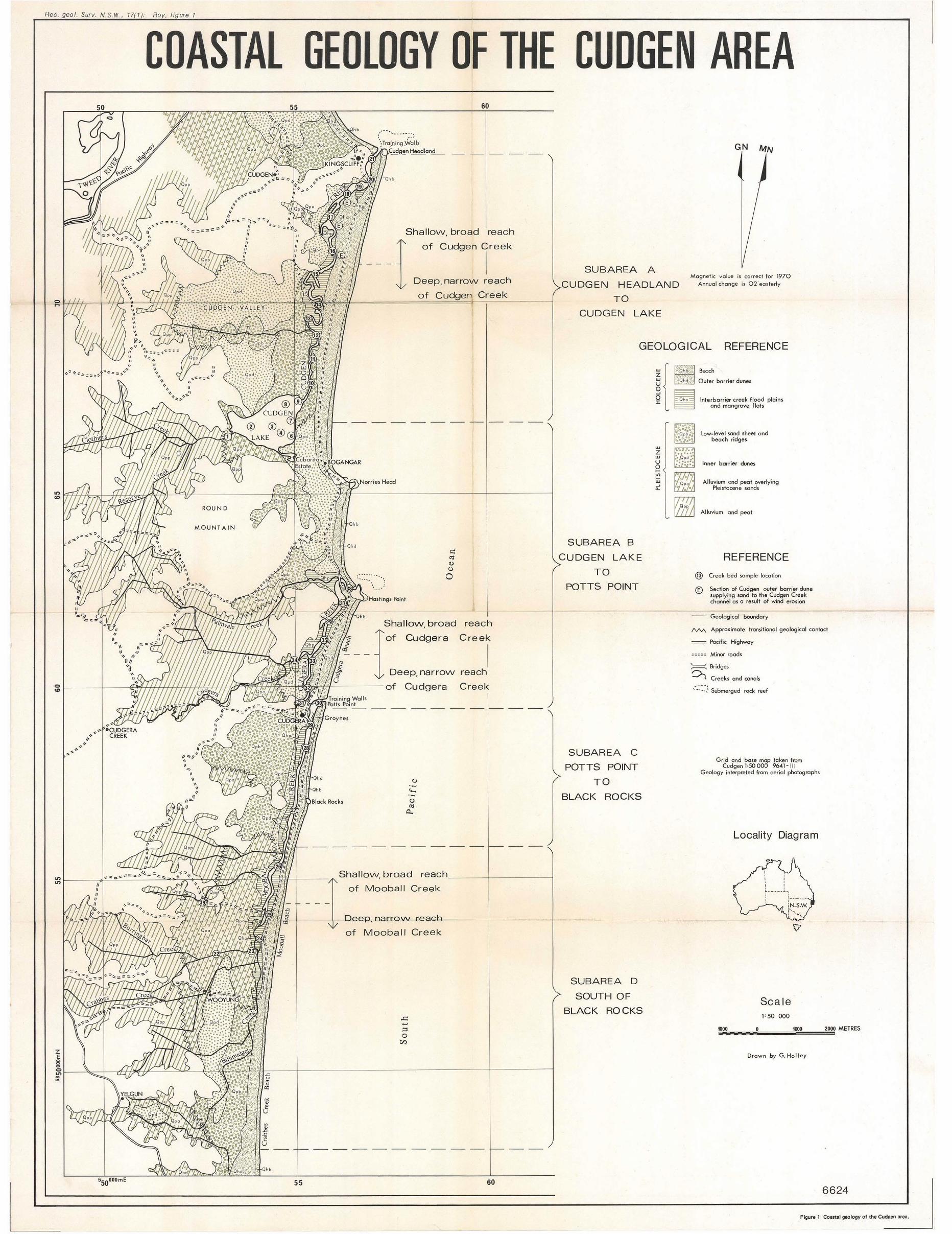
flooding regime of the area, or is due mainly to a real physical deterioration of the drainage systems through man-induced changes. Very probably both factors are involved. In assessing the geological situation, observations were made of the processes operating in the creeks under present day conditions and inferences were drawn as to the likely effects over a period of time of some of the developmental activities. The distribution of unconsolidated sediments in the study area is shown on figure I.
THE COASTAL PLAIN
Physiography
The coastal plain is characterized by straight beaches and narrow coastal dunes, backed by swampy sand flats and flood plains which infill the generally small coastal valleys. More than 95 per cent of the coastline is composed of long, practically straight, beaches backed by a narrow coastal dune system (0·8 km wide in the north , decreasing to 0·2 km in the south), less than 15 m in height.
The present day coastline from Kingscliff south to Cape Byron has resulted from the accretion of sand by marine processes. Tt has reached a mature stage of development, and the embayments between the headlands have almost completely been infilled. Headlands in this area no longer trap the sediment which is littoral drifting northwards along the coast under the dominant southeasterly wave climate. Consequently the coastline is no longer accreting ; on the contrary it is believed by the author that the long-term process now operating is one of coastal erosion.
Bedrock headlands and low submarine rock reefs occur at Kingscliff, Norries Head, Hastings Point, Potts Point, and Black Rocks. These constitute the eastern ends of irregular spurs that protrude in a northeasterly and easterly direction from the hilly country 5 to 8 km inland. Topographic relief in this coastal zone rarely exceeds 160 m in elevation. Between the bedrock spurs, sediments of both marine and fluvial origin have infilled the valleys to form broad, flat, low-level flood plains. Their elevation generally rises from 1·5 m above sea level near the coast, to over 4 m above sea level at the heads of the valleys. Much of this lowland has been artificially drained and cleared for sugar-cane cultivation. Because of variations in sediment types, the valleys are generally fertile and have been cultivated in the west, while in the east low-lying, thickly vegetated sand swamps between I and 2 km wide occur adjacent to the coastal sand barrier. Periodic flooding is widespread in this area, and floodwaters are only slowly released into the sea via the coastal creeks.
Three creeks-Cudgen in the north, Cudgera, and Mooball in the south-flow northwards behind the coastal sand barrier. Cudgen Lake is situated at the southern end of Cudgen Creek. The creeks lie between two coastal barrier sand deposits of different ages and are termed "illterbarrier creeks". The catchment areas of the three interbarrier creeks are approximately 66 km' for Cudgen Lake and Creek, 50 ken' for Cudgera Creek, and 117 km' for Mooball Creek. Tributary streams flow from the west into the interbarrier creeks: Burringbar and Crabbes Creeks flow into Mooball Creek, Cudgera and Palmvale Creeks flow into Cudgera Creek, and Clothiers and Reserve Creeks flow into Cudgen Lake. Under non-flood conditions the interbarrier creeks are tidal for most of their length and saline waters even penetrate for a short distance up the tributaries.
COASTAL GEOLOGY CUDGEN AREA 43
Geology
The sediments of the coastal plain and their depositional history are discussed in general terms below. This is followed by a detailed description of the coastal zone, which has been divided into four subareas.
GEOLOGICAL HISTORY
Undifferentiated Palaeozoic metasediments, overlain in the north b)< Tertiary basalts, form irregular northeasterly trending bedrock spurs that terminate in the coastal plain. The upper reaches of the valleys between the spurs are infilled with argillaceous alluvium, and the lower reaches with marine sands partially overlain by peat and alluvium.
Low sea-level stands (glacial regressions) during the Pleistocene Epoch resulted in erosion of the bedrock topography. Subsequently, alluvial valley-fill deposition produced an undulating substrate, gently sloping seaward. A succession of high sea-level stands (interglacial transgressions) during the Pleistocene resulted in the deposition of marine sediments in the valley embayments to form a coastal plain. Sands accumulated in nearshore, beach, and dune deposits which are wedge shaped in section, being 50 m or more thick beneath the shoreline anc! thinning in both a seaward and a landward direction. These Pleistocene sand deposits are termed inner barrier sands (Thorn 1965). In the study area they occur ill two forms :
(I) Slightly elevated dunes, less thall 7 m in height, often forming subparallel ridges
(2) Low-level sand sheets, which occasionally have parallel beach ridges and are usually swampy and flood prone.
Groundwater movements within the sand deposits have resulted locally in the mtroduction of colloidal humic material which acts as a cementing agent to form layers of dark-brown indurated sand (waterloo rock or sandrock). Induration of the sand in this way has contributed to its preservation during subsequent periods of erosion . Indurated sand occurs over a wide area and crops out in Cudgera and Mooball Creeks slightly above midtide level.
The coastline at the end of the Pleistocene Epoch was probably similar to its present day configuration, with long straight beaches linking headlands.
Contemporaneous with the formation of the coastal sand deposits, fluvial processes resulted in the deposition of silts and clays in the heads of the coastal Valleys. The alluvium gradually prograded seawards over the inner edge of the Pleistocene sand deposits. The extent of the alluvium cover is directly related to the size of the valley drainage system, and is consequently most widespread on the valleys of the relatively large creeks. In smaller valleys with restricted catchments alluvial deposits are very limited and marine sands are exposed. The marine sand beneath the alluvium in the larger valleys is generally only seen in spoil from canal excavations; consequently the landward extent of the sand shown in figure 1 is onl} approximate, and in some valleys may extend even further inland. Probing and drilling by the New South Wales Department of Main Roads (D.M.R.) in the southern portion of the study area indicate as much as 2·5 ill of alluvium overlying sand at distances of 2 kID from the coast. Marine sands here are found to depths of more than 7·5 m beneath the surface. Peat, up to 2 m thick, occurs as in situ swamp deposits overlying sand or alluvium in areas where the present rate of clastic sedimentation is very low (D.M.R. pers. comm.). The improved drainage resulting from the excavation of canals is possibly responsible for some shrinkage of the superficial peat deposits. Reports of subsidence may be attributed to this phenomenon but would only be of a minor degree (less than 100 mrn).
44 P. S. ROY
The Pleistocene Epoch was terminated by the Wurm, or Wisconsin, glaciation which caused a fall in sea level and resulted in some erosion and reworking of the pre-existing sand deposits. At the beginning of the Holocene, about 18000 years ago, the Postglacial Transgression initiated a rapid rise in sea level which ended about 7 000 years ago when the sea reached approximately its present level. During this event, marine quartzose sands, eroded and deposited on the exposed continental shelf during the preceding low sea-level stand, were remobilized and carried shorewards by the transgressing wave front . Their accretion on the pre-existing Pleistocene shoreline resulted in the development of the present day longitudinal coastal barrier and beach complex. These deposits are termed the outer barrier sands (Thorn 1965).
In comparison to the inner barrier deposits, the outer barrier is narrow but relatively high, with dunes rising to slightly more than 10 m above sea level in the study area. They lie on the gently sea wards sloping surface of the older sand deposit. Indurated sand layers, which commonly form the erosional surface of these older deposits are exposed slightly above mean sea level in some of the interbarrier creeks at the rear of the outer barrier dunes.
The outer barrier dunes along the coast effectively blocked the pre-existing creeks from entering the sea directly and resulted in their northward deflection behind the coastal barrier (see discussion below). Tidal action and periodic flooding have deposited sand and superficial silts to form salt marshes and mangrove flats along the creek banks. The beds of the creek are generally sandy with some muds occurring in their upper reaches.
DETAILED DESCRIPTION
The distribution of sediments within the coastal zone is controlled by three factors : (1) The configuration of the original embayments (2) The size of the creek flowing into the embayments (3) The rate of supply of marine sands.
For descriptive purposes the coast has been divided into four subareas as shown on figure 1.
Subarea A-Kingscliff to Cudgen Lake In the northern half of subarea A bedrock hills approach close to the coast and are
flanked by narrow inner barrier dunes underlain by indurated sands containing rounded pebbles. In the southern half of the subarea, bedrock spurs inclose a broad-mouthed, shallow valley (Cudgen Valley) with a small catchment area. This embayment is almost completely infilled by parallel inner barrier dunes (more than 3 km wide) with only minor alluvium developed at the heads of four small tributary valleys. The outer barrier is also relatively well developed in this subarea and reaches a maximum width of 0·7 lan. A broad zone of lOW-level swampy sands occupies a central position between the inner and outer barriers and also occurs in a meandering strip which cuts through the inner barrier dune ridges. Cudgen Creek meanders northwards behind the outer barrier and lies within a recently formed salt-marsh/mangrove swamp.
The wide mouth of the Cudgen Valley embayment allowed marine sands to be deposited by waves far inland. The extensive development of both the inner and outer barrier dunes in subarea A indicate a high rate of sand supply in the past. Cudgen Headland at Kingscliff presumably acted as a major physical barrier to sand transported northwards along the coast by wave action. The sediment trapped on the southern side of this headland formed a reservoir from which sand was blown inland to form the parallel dune ridges infilling Cudgen Valley and, in more recent times, the coastal dunes. Sand derived from this source was even blown onto the top of Cudgen headland where it now forms a superficial dune sheet.
COASTAL GEOLOGY CUDGEN AREA 45
The central low-lying sand sheet between the inner and outer barriers formed through the meandering of Cudgen Creek (and to a lesser extent its tributary), which reworked the pre-existing Pleistocene dune sands. The depression now filled by Cudgen Lake was probably also excavated at this time. The absence of near-surface layers of indurated sand (p. Searl, D.M.R., pers. comm.) which would normally resist erosion, is probably responsible for the extensive meandering of Cudgen Creek. In contrast, indurated sand is well developed beneath Cudgen and Mooball Creeks further south and has restricted the extent to which the pre-existing dunes were modified by subsequent phases of erosion.
Subarea B-Cudgen Lake to Potts Point
Subarea B is characterized by narrow-mouthed valleys, prominent bedrock hills, and a fairly thin coastal plain. Moderately large creeks flow into Cudgen Lake in the north and into Cudgera Creek further south. Marine sediments are generally poorly developed and, because of the constricted valley mouths, do not extend far inland. Extensive deposits of alluvium and minor peat, infill the valleys and overlap tbe inner edges of tbe marine sands.
In the northern half of this subarea, between Round Mountain and the coast, marine deposits gradually increase in heigbt in a seaward direction. Pleistocene low-level swampy sands occur in tbe valley mouths ; slightly elevated and irregular inner barrier dunes occupy a fairly wide central zone; and narrow outer barrier dunes border the present coastline between Norries Head and Hastings Point.
In the southern half of this subarea remnants of northwesterly-southeasterly trending dune ridges of Pleistocene age occur in a small embayment to the west of Potts Point. Their inner edge is overlain by extensive deposits of peat and minor alluvium. To the north of Potts Point, coastal dunes up to 0·5 km wide obscure the underlying Pleistocene deposits. Cudgera Creek, which flows northwards against the inner edge of the coastal dunes, contains numerous exposures of indurated sand along its whole length.
Subarea C- Potts Point to Black Rocks
Two small, broad-mouthed valleys occur in subarea C and are almost completely infilled with a low swampy Pleistocene sand sheet up to 2 km wide. Because of their small catchments alluvium is practically absent in these valleys although peat up to 2 m thick has accumulated on sand at their heads. The seaward edge of the sand sheet is bordered by a narrow, poorly developed Pleistocene dune. An equally narrow, altbougb higher, outer barrier dune forms the present day coastline. The unusually straight interbarrier depression between these dunes is occupied by the lower reaches of Mooball Creek which flows northwards and enters the sea at Potts Point. Salt marshes and sand flats with some mangroves occur along the western side of the creek.
Subarea D- South of Black Rocks
Subarea D is characterized by relatively large valleys and drainage systems. Bedrock spurs do not reach the coast as headlands, but terminate in an extensive coastal plain 1 to 3 km wide. The narrow outer barrier dune, described in subarea C above, continues unbroken through subarea D. The coastal plain is composed of Pleistocene marine sands that extend at least 2·5 km inland and incorporate a longitudinal dune, approximately 4 km long from north to south, the northern end of which has been partially destroyed by rejuvenated stream action . A small remnant of Pleistocene dune sand occurs as an isolated outcrop in the southernmost valley of this subarea. It is situated over 3 km inland in a fairly narrow valley surrounded by alluvium, and may conceivably be older than the larger
46 P. S. ROY
Pleistocene dunes. The valleys are infilled with alluvium which extends beyond their mouths and, together with superficial peat, covers much of the marine sands. These sands are only exposed on the seaward side of the longitudinal dune which, because of its height, has acted as a partial barrier to the eastward dispersal of river silts by flood waters.
The upper reaches of Mooball Creek flow northwards behind the outer barrier into subarea C.
THE INTERBARRIER CREEKS--CUDGEN, CUDGERA, AND MOOBALL CREEKS AND CUDGEN LAKE
General
Cudgen Creek is located in the northern part of the study area and follows a meandering course 9·4 krn in length between Cudgen Lake and the sea, a distance of 6·7 km. The main drainage is supplied via the lake by Clothiers Creek augmented by a small canal which drains Cudgen Valley and joins Cudgen Creek about one-third of the way along its course.
Cudgera Creek, which is located in the central part of the study area, has a fairly straight channel only 3·5 km in length. Part of the drainage from its catchment enters Cudgera Creek about 2 km from its mouth ; the rest flows via Palmvale Creek directly into the sea behind Hastings Point. The upper (or southern) end of Cudgera Creek has practically no catchment area and is a relic feature formed in the past when Mooball and Cudgera Creeks were joined behind Potts Point. The coastal barrier at this time stretched unbroken from Hastings Point southwards to Brunswick Heads. Following the breakthrough of Mooball Creek at Potts Point, the upper reach of Cudgera Creek was isolated.
Mooball Creek, located in the southern part of the study area, is characterized by an unusally straight channel which extends for about 9 Ian south of its mouth at Potts Point. With a catchment area of 117 lan', it is the largest of the three interbarrier creeks. The southern end of Mooball Creek merges with Billinudgel Creek in an area of low-lying sand swamps. Further downstream Mooball Creek is joined by the Crabbes/Burringbar Creek canal, which is the major drainage system in the area, as well as a number of smaller tributaries.
Cudgen Lake (approximately 1·65 km 2 in area) lies within the coastal plain at the southern end of Cudgen Creek. Clothiers and Reserve Creeks, with a combined catchment area of 33 bo', flow into the lake from the west. The lake is less than 2 m deep and its bottom sediments are composed of soft black mud, fine carbonaceous detritus, and faecal pellets derived in situ from botton-living organisms. Relic quartzose sands of Pleistocene age crop out around the northern and eastern margins of the lake and are related to the adjacent low, swampy sand sheet. The lake acts as a retention basin which attenuates the effect of flooding in Cudgen Creek. The flood discharge flowing into the lake is in the order of 140 to 280 m3/s (5000 to 10 000 cusecs) into the lake which rises up to J'5 m above its normal level and spreads over the low-lying, thickly vegetated areas to the north. The area affected by flooding is in the order of three times that of the lake under non-flood conditions. The floodwaters are released over a prolonged period into Cudgen Creek, and thence into the sea, at an approximate discharge rate of 2·8 to l4m3/s (100 to 500 cusecs) or one-twentieth of the inflow rate. Discharge figures are based on flood measurements made in February 1973 by the Department of Public Works. New South Wales (P.W.D.) (R. Perry pers. comm.).
COASTAL GEOLOGY CUDGEN AREA 47
Geology
The historical development of the interbarrier creeks, as reflected in their orientation, the development of a straight or meandering course, and the sediment in their channels, is discussed below.
ORIENTATION
The creeks in the study area all drain northwards behind the coastal barrier and enter the sea in the vicinity of a headland. Elsewhere along the New South Wales coastline, inter barrier creeks show both northerly and southerly deflections. The mode of formation of coastal sand barriers within the last 10000 years is basically responsible for the configuration of these interbarrier creeks. The most important dynamic factor in controlling their orientation is the dominance, along the New South Wales coast, of a residual northwards transport of sediment (littoral drift). The most important physical control is the disposition and size of headlands, offshore reefs, etc., at either end of the embayments.
A northward deflection of an interbarrier creek occurs where the coastline is relatively straight and mature, and the headlands at either end of the embayment are ineffective barriers to littoral drift. The coastal barrier dunes in such embayments are fairly evenly developed, indicating a uniform rate of sand accretion along the length of the beach. In the early stages of barrier development, creek outlets are forced northwards by the dominant littoral drift. As the barrier accretes, the creeks are deflected progressively further north until the northern headland is reached . At this point an outlet is maintained as the result of a balance between river scouring and beach build-up. Commonly the outlet of such inter barrier creeks is located in the protection of a rock reef adjacent to the headland, e.g., Cudgen and Cudgera Creeks.
A southward creek displacement generally only occurs where the southern headland of an embayment extends into deep water or incorporates offshore reefs and islets, which act as a significant barrier to littoral drift. Eddy currents and a partial wave-shadow zone occur on the northern side of such an obstruction. A "zeta" -shaped embayment results with a low-energy environment at its southern end where the creek mouth is situated. Coastal barrier dunes characteristically increase in width and height from south to north in these embayments, and reflect an increasing rate of sand deposition in a northerly direction. During the early stages of the growth of the barrier, creeks preferentially break through towards the southern end of the embayment where the dunes are lowest. The progressive southward deflection of the creek mouth is therefore directly attributable to the disparity in the sedimentation rates between the northern and southern ends of the embayment.
MEANDERS-STRAIGHT CHANNELS
A distinctive characteristic of Cudgen Creek is its meandering course compared with the straight channels of Mooball and Cudgera Creeks. This discrepancy is due to the presence, beneath Mooball and Cudgera Creeks, of a gently seaward-sloping indurated sand substrate which is resistant to erosion. The slightly seaward slope of the indurated sand layer confines the creek against the straight inner edge of the coastal dunes. In contrast, indurated sands are not exposed in Cudgen Creek which flows through a broad zone of low sand flats. In this easily eroded material, natural hydrodynamic processes inevitably produce a meandering stream pattern, (Leopold et al. 1964).
48 P. S. ROY
BOTTOM SEDlMBNTS
Thirty-nine dredge samples were collected in the beds of the creeks and in Cudgen Lake at locations shown on figure I. The mud/sand ratio was measured and the washed-sand fraction examined microscopically.
The dominant sediment in the interbarrier creek is fairly clean sand of uniform composition derived primarily through reworking of the marine sands forming the coastal plain. Lithologically it is orthoquartzitic, fine to medium grained, moderately well sorted, and subrounded to rounded; rock and wood fragments are rare and, except at the creek mouths, shell fragments are absent. In general, mud is only found in Cudgen Lake, in the isolated section of Cudgera Creek, and in the upper reaches of the tributary streams and canals. The mud is composed of silt, clay, and fine carbonaceous material derived through erosion of the alluvium in the valleys and of the hillsides in the hinterland. Slightly muddy sands occur in the beds of the tributary streams and canals where they traverse old deposits of marine sand underlying the valley alluvium. Around the edge of Cudgen Lake and in upper Cudgen Creek (samples 7, 9, 11 , and 12) a superficial, 10 mm thick, bottom layer composed of yellow ironstained quartz grains occurs. Some diagenetic process of in situ chemical oxidation is responsible, and indicates that the sand at the site is immobile (neither depositional nor erosional processes are active). Much of the sand sampled in Mooball and Cudgera Creeks is coated with brown carbonaceous material and has been derived through the erosion of indurated-sand outcrops in the creek beds.
The interbarrier creeks in the study area are divisible into two reaches: a narrow and relatively deep upstream reach and a broad and shallow downstream reach (see figure I).
The upstream reach is between 1 and 2 m deep with relatively steep and high level banks. The bottom sediment is generally slightly muddy sand. Erosion occurs mainly as a result of bank undercutting during floods ; tidal action is minimal because of the distance from the creek mouths. Reworked sand is deposited as overbank deposits, or in spits on the inner side of the bends. In general it would appear that sediment is transported through this reach; reworking is a more important process than either deposition or erosion.
The lower reach is characterized by a broad channel between 50 and 100 m wide and less than I m deep. The bottom sediment is clean sand which forms a complex of mobile banks and interfingering channels. Scattered "reefs" of indurated sand are exposed in the beds of Mooball and Cudgera Creeks in this reach. Deposition and reworking are the dominant sedimentary processes operative. Sand is transported seawards through the upstream reach and accumulates in the lower reach on the broad shallow sand flats which tend to prograde slowly upstream. Bank erosion of the inner edge of the coastal dunes is also responsible for supplying sediment to this reach. Aeolian processes are an important factor in this regard and are discussed more fully below.
An examination of the shell content of the bottom samples indicates that modern beach sand, washed into the creek mouths by waves and flood tides, does not penetrate further than 300 to 500 rn upstream. It is not, therefore, a significant factor in causing siltation.
Calculations of sand movement in Cudgen Creek during floods has been carried out by P. Stone (University of New South Wales, Water Research Laboratory, pers. comm.), and are based on a discharge rate of 14 rna/s (500 cusecs), sand 0·3 mm in diameter, a channel width of30 m, a water depth of 0·6 m, and a water slope of I in 6 000. Under these conditions, the quantity of sand transported over the creek ·bed is in the order of 0·028 rna/min (I fl3/min). A flood lasting 4 days would transport only 140 rns of sediment through the lower reach of
COASTAL GEOLOGY CUDGEN AREA 49
Cudgen Creek and (presumably) into the sea. Flood discharge cannot therefore he considered as a significant mechanism for scouring the creek bed and counteracting siltation. It is reasonable to assume that the quantities of sediment transported in Cudgera and Mooball Creeks is similar to that in Cudgen Creek.
Man's Inftuence
The impact of man on the regime of the interbarrier creeks may be considered under four categories:
(I) Construction of bridges and training walls (2) Beach-sand mining (3) Agriculture (4) Development of canal estates.
BRIDGES AND TRAINING WALLS
Bridges cross all the creeks, and training walls have been built at the mouths of Cudgen and Mooball Creeks. Bridge abutments constrict the channels of Cudgen Creek to a width of 37 m, Cudgera Creek to 57 m, and Mooball Creek to 92 m. Although the Cudgen bridge impedes discharge to the greatest relative extent, it is not considered an important factor influencing the flood regime of the creeks, (W. Hulcome, P.W.D. , pers. comm.). However eddy currents have been created by the abutments of the bridges in Cudgen and Mooball Creeks and are causing moderately severe erosion of the inner edge of the coastal dunes downstream from the bridges. Undercutting has formed scarps 3 m high, and considerable quantities of sand have been deposited in the creek channels over the years. Recently a number of small groynes have been constructed in Mooball Creek to inhibit this erosion.
The small training walls at the mouth of Cudgen and Mooball Creeks have stabilized the position of their outlets and inhibited their shoaling and blockage during periods of low stream discharge. They do not, however, appreciably influence sedimentation in the creeks.
BEACH-SAND MINING
All the coastal barriers in the study area have been mined for heavy minerals. The barriers adjacent to lower Cudgen Creek has undergone at least three, and possibl)' more, episodes of mining over the last 20 years, and even parts of the creek bank have been disturbed. As a consequence, large areas of loose sand have been exposed to wind erosion for periods before revegetation. Between the Cudgen Creek bridge and 2·5 km upstream, three separate segments of dune (totalling 1"4 km in length) are particularly susceptible to wind deflation. In these areas the channel of Cudgen Creek lies directly against the inner edge of the coastal dunes, with the result that northeasterly, easterly, and southeasterly winds blow sand directly into the creek. Elsewhere mangroves border the creek and trap most of the wind-blown sand before it reaches the channel.
By using Bagnold's graph, which shows the relationship between wind speed and sediment load (ill Zenkovich 1967), conservative estimates have been made of the quantities of sand Likely to be blown into the lower reach of Cudgen Creek. The result is given as an average yearly figure for sand transported per metre length of coastline. Wind data collected from nearby over a 5-year period (1961 to 1967) for the Gold Coast beach-erosion study (Delph Hydraulics Laboratory 1970) was substituted in the graph.
50 P. S. ROY
It was calculated that approximately 250 t of wind blown sand per year (or 21·6 t per average month) per metre length of dune, is mobilized. Assuming that I 400 m length of dunes is subjected to this form of erosion, an average of 30 000 t of sand is mobilized per month. Not all this sand reaches the creek, some sand is probably trapped in hollows on the surface of the dunes. To compensate for this loss, the total quantity has been empirically reduced by 30 per cent to 21 000 t blown into the creek per month . It is further assumed that the practice of progressive mining exposes loose sand to wind erosion for at least 2 months before it is restabilized by vegetation. Consequently, wind erosion of the dunes adjacent to Cudgen Creek resu lts in the deposition of 42 000 t of sand in the creek channel each mining operation. Repeated mining (assuming three episodes) has resulted in a total of 126000 t of sand deposition since mining began. (An exposure period of 2 months before the dunes are revegetated is probably a conservative estimate- rehabilitation procedures at the time of the early mining operations were inadequate, and repeated mining in this area has destroyed most of the natural top soil, with the result that a much longer time probably elapsed in the past before the sand was stabilized by vegetation. At the time of the recent field inspection, extensive dune surfaces to the west of the coast road were completely bare and, according to local reports, had been so for the past 6 months.)
A subsidiary resu lt of mining is seen where Cudgen Creek meanders against the mined dunes. The sparsely revegetated sand offers no protection against bank erosion, with the result that undercutting has formed scarps 3 m high at two localities about 2 and 3 km respectively upstream from the bridge.
From the combined effects of wind and bank erosion, it is conceivable that over the past decade or two, as much 140000 t (or approximately 106000 yd3) of siltation has occurred in Lower Cudgen Creek. Spread over a channel 3 km long and 100 m wide, this addition represents an average shoaling of 0'25 m.
In contrast to Cudgen Creek, only minor siltation has occurred in Mooball and Cudgera Creeks as a result of beach-mining activities. A number of factors are responsible;
1. The coastal dunes in these areas were only mined once and were rehabilitated fairly rapidly afterwards. The period of exposure of the loose sand to wind erosion was therefore minimized.
2. The presence of indurated sand layers cropping out slightly above mean sea level has prevented bank erosion in the channels.
3. The dunes adjacent to Cudgera Creek are somewhat lower than those against the beach further to the east; the latter act as a windbreak and reduce onshore wind velocity in their lee.
These factors have been tak.en into account empirically by reducing by about 50 per cent the calculated volume of sand poteiltially eroded by wind to to t per month per metre length of dune. Thus, the approximate total quantity of sand added to Cudgen Creek as a result of sand mining is estimated to be 12000 t spread over 3 km of channel, resulting in an average shoaling of 50 mm. In Mooball Creek the calculated approximate total quantity of sand deposited in the lower 4·2 km of the channel is about 34 000 t, resulting in an average shoaling of 60 mm.
AGRICULTURE
Where alluvium and peat occur on the coastal plain, the land has been cleared, drained, and cultivated for sugar cane. On some of the nearby hi llsides banana plantations have been established . The clearing of land and the excavation of canals has probably increased the silt load carried by the drainage systems. However, this fine-grained sediment is not being
COASTAL GEOLOGY CUDGEN AREA 51
deposited in the lower reaches of the interbarrier creek channels and is consequently not a serious cause of siltation. Cudgen Lake, on the other hand, is probably silting up somewhat more rapidly because of the impact of agriculture. Data from similar coastal lakes (Fullerton Cove near Newcastle) suggests a deposition rate of between 10 and 20 mm per 10 years. This is not considered an important factor in the present study since deposition on the lake bed does not influence the flood regime of the system significantly.
CANAL ESTATE DEVELOPMENT
At present canal estate development is restricted to the southeastern corner of Cudgen Lake where an estate has been built on sand dredged from canals dug in the lake foreshore. Floodwaters rise in the lake and naturally spread over the adjacent lowlands and, on rare occasions, have partially inundated the land reclaimed by the development. It is felt that this flooding is basically due to the reclaimed land being lower than the peak flood levels in the lake. Contrary to local feeling, there is no evidence that either natural or man-induced changes have significantly altered the flood levels in the lake in recent times. Although shoaling at the mouth of Cudgen Creek has increased the release time for floodwaters impounded in the lake, it has not influenced their height, which is due soleI) to the rainfall intensity and the volume of the retention basin.
From a hydrodynamic aspect, the environmental success of a canal development depends upon the flushing action of tidal exchange which removes those potential pollutants inevitably produced by urban development. River flow or periodic flooding is no substitute for tidal action unless the canals form part of the active river system and are not backwaters.
In view of the difficulty and expense of dredging and maintaining a direct channel through the coastal dunes to the sea, this is not seen as a realistic solution to the problem of improving the tidal exchange in the lake. The major difficulties which would be encountered would be the blockage of the channel mouth by sand deposited by wave action. and up-drift coastal erosion which would possibly result from the construction of breakwaters needed to maintain a tidal exchange through a permanent opening. In addition. the regime of Cudgen Creek between the lake and the sea would be affected by diverting the drainage of approximately 60 per cent of its catchment area through the new outlet. Whether this effect would be detrimental or not is unknown.
Canal estate-type development has a further impact on the regime of coastal creek systems. By reclaiming low-lying swamp areas adjacent to lakes and creeks, the area available for the retention of flood waters is reduced. Flood levels are heightened (this is now happening in parts of the Gold Coast canal developments) stream velocities are increased, and channel erosion may become a problem. The Cudgen Lake development has a negligible impact in this regard, but future developments should be restricted or very carefully controlled.
CONCLUSIONS AND RECOMMENDATIONS
The coastline in the study area has reached a mature stage of development. and has probably now entered a long-term erosional phase. This erosional trend is gradual and is masked by the more dramatic cut and fill processes caused by short-term changes in the wave climate. The narrow dunes and beaches should be regarded as fragile and vulnerable coastal components, and urban developments should be planned accordingly. The narrow dunes adjacent to Mooball Creek are especially vuLnerable to coastal erosion and it is recommended that they be revegetated but not developed.
52 P. S. ROY
The coastal plain is naturally prone to flooding; it acts as a retention basin for flood waters which are released slowly into the interbarrier creeks. The bottom sediment in all interbarrier creeks, except in the upper reach of Cudgen Creek, is fairly clean quartzose sand derived by local reworking of old coastal sand deposits. The lower reaches of the interbarrier creeks are subjected to siltation ; this is especially a problem in lower Cudgen Creek. Sand, blown into the creek channels from adjacent mined dunes, eroded from the creek banks, and introduced from further upstream during floods, is responsible for the siltation. Sand washed into the creek mouths by waves and tidal currents is not of major importance. The velocity of flood flow in the interbarrier creek. is an inadequate scouring mechanism to counteract shoaling in the lower reaches. As a result of siltation tidal exchange has probably declined significantly in Cudgen Creek.
Rehabilitation of the coastal dune surfaces to prevent wind erosion of mined areas is the main preventative measure recommended to combat siltation in Cudgen Creek. Companies mining the adjacent dunes should be encouraged to restore the vegetation cover as quickly as possible. As a remedial measure, dredging of the bed of lower Cudgen Creek between 0'5 and 3'5 km from its mouth would be beneficial in improving the tidal exchange. If the old coast road bridge is to be superseded, the new bridge should be of open construction to minimize its interference with flood discharge and tidal flow. The old bridge and its abutments should be removed to overcome the bank erosion they are causing. Erosion of the inner edge of the dunes further up stream in Cudgen Creek should be combated by dune rehabilitation and appropriate protection works used in concert with dredging of the channel beds. Although it is difficult to prove a causal relationship between mining and bank erosion in parts of Cudgen Creek, a satisfactory alternative explanation for this phenomenon is not apparent.
The upper reaches of the interbarrier creeks are relatively stable except for minor lateral channel migration in Cudgen Creek, due to the absence of a resistant indurated sand substrate. A slight improvement of the flood regime of Cudgen Lake may be achieved by straightening some of the more extreme meanders in the upstream reach of Cudgen Creek. The duration of flooding in the lake may be lessened and tidal penetration improved by this measure.
Cudgen Lake is a natural flood retention basin, the regime of which has not dramatically changed in recent times. Minor changes have occurred gradually through the progressive clearing and drainage of the hinterland with the result that the rate of mud accumulation on the lake bed has probably increased. However, it is considered that neither this factor, nor the siltation at the mouth of Cudgen Creek, have significantly altered the flood regime of the lake.
Canal estate-type development is unsound in a non-tidal environment. Consequently, it is recommended that canal estates be restricted in Cudgen Lake and the feasibility of new proposals in other swamp areas adjacent to the interbarrier creeks be very carefully assessed in hydrodynamic terms.
To open an artificial channel between the sea and Cudgen Lake is not considered a viable method of increasing the tidal range in Cudgen Lake, unless adequate finance is available to overcome the problems discussed in this report.
REFERENCES DELFT HYDRAULICS LABORATORY, 1970, Gold Coast, Queensland, Australia. Coastal Erosion and Related
Problems, Vols I and II. Delft Hydraulics Laboratory, Delft. LEOPOLD, L. '8. , WOLMAN, M. G.,and MfLLER,I. P., 1964. Fluvial Processes in Geomorphology. 522 pp.
W. H. Freeman and Company, San Francisco. l'HOM, B. G., 1965. Late Quaternary coastal morphology of the Port Stephens-Myall Lakes area, N.S.W.
i. Proc. R. Soc. N.S. W., 98 (I), 23-36, 4 figs, 3 pIs. ZENKOVl'~H. V. p. 1967. Process of Coastal Development. 738 pp. Oliver and Boyd, London.
Rec. geol. Surv. N. S. W. , 17( 1): Roy, fig ure I
COASTAL GEOLOGY OF THE CUDGEN AREA 60
~~-----' ,
ng_v:,~lIs ~g~n Headlan_d_
Shallow, broad reach
of Cudgen Creek
):'~.:/::;;~ Ii:';; ;;. ': ":' '::':"i:;::::,~:'V::"" I Deep narrow reach
. _:.::::: :'.:.:. ~ :.~:::::. :-:(f.:oo:: .:.::.::;:.::0:::.: .:.:::: :'0 .. -\ w' '::':;':::::':':"::~~':':-::":":""'';''''':: .~ of Cudgen Creek
~ ' .. 0 ... ::;', :.~~~; : :.:;: oJ ' ,: ::,::::'v':~:;'~ ~:::'" :0_.0 _ '
Jie~?4?:1--- -- -- -- -- -- -- --- , -- - - --
~Norries Head
~ ~hifl~~~~~~~~~~~~~~R~O~U~N~D--~=:~~~~~~~~~~
II ~\\
II // ~ /,
JIll '~l
MOUNTAIN
:g I I ~JJJ////IJjI///Jan'fl!~jdr?j
.,. .,. .,. '" .,.
,.....f\:~~,,.~l)Hastjnas Point
c:: C<l ~ U
o
Shallow, broad reach
of Cudgera Creek
Deep, narrow reach
'1° of Cudgera Creek
u .-4-. .-U C<l
a..
-. Shallow broad reac - -- -- ~-., ~;t1tmlf'~'(r I If\- ' :gl "'I ~--- ~-:":;r{) '< 4 .>':'Q\rJ I of Mooball Creek
Z E o o g I ~ ff/;:f.{br lr'/...LD r;;'I"t'~'~';:;'~:V;i II') -.....'-..... 1 •••.• "),:! O.OAv6.0 .6 ,',~;:
= '"
b
55
Deep, narrow reach
of Mooba II Creek
.c ...... ~ o
rn
60
GN MN
SUBAREA A Magnetic value is correct for 1970
UDGEN HEADLAND Annual change is 02 'easterly
TO
CUDGEN LAKE
GEOLOGICAL REFERENCE
SUBAREA B
CUDGEN LAKE
TO
POTTS POINT
C SUBAREA
POTTS POINT
TO
BLACK ROCKS
SUBAREA D
SOUTH OF
BLACK ROCKS
w Z w U o ~
o I
w Z w U 0 l-V)
w ~ 0-
tj:~t;~l
II
~
Beach
Outer barrier dunes
Interbarrier creek flood plains and mangrove flats
Low-level sand sheet and beach ridges
Inner barrier dunes
Alluvium and peat overlying Pleistocene sands
Alluvium and peat
REFERENCE
@ Creek bed sample location
® Section of Cudgen outer barrier dune supplying sand to the Cudgen Creek channel as a result of wind erosion
Geological boundary
IV'v\ Approximate transitional geological contoct
Pacific Highway
Minor roads
~ Bridges
c:>t Creeks and canals
.:..--~ ~~ Submerged rock reef
Grid and base map taken from Cudgen 1,50000 9641-111
Geology interpreted from aerial photographs
Locality Diagram
\7
Scale l' 50 000
1000 0 1000 2000 METRES
Drawn by G. Holley
6624
Figure 1 Coastal geology of the Cudgen area,