Embed Size (px)
Citation preview
Mapping Plus Ultra: Cartography, Space, and Hispanic ModernityAuthor(s): Ricardo PadrónSource: Representations, No. 79 (Summer, 2002), pp. 28-60Published by: University of California PressStable URL: http://www.jstor.org/stable/3176061Accessed: 02/02/2009 16:40
Your use of the JSTOR archive indicates your acceptance of JSTOR's Terms and Conditions of Use, available athttp://www.jstor.org/page/info/about/policies/terms.jsp. JSTOR's Terms and Conditions of Use provides, in part, that unlessyou have obtained prior permission, you may not download an entire issue of a journal or multiple copies of articles, and youmay use content in the JSTOR archive only for your personal, non-commercial use.
Please contact the publisher regarding any further use of this work. Publisher contact information may be obtained athttp://www.jstor.org/action/showPublisher?publisherCode=ucal.
Each copy of any part of a JSTOR transmission must contain the same copyright notice that appears on the screen or printedpage of such transmission.
JSTOR is a not-for-profit organization founded in 1995 to build trusted digital archives for scholarship. We work with thescholarly community to preserve their work and the materials they rely upon, and to build a common research platform thatpromotes the discovery and use of these resources. For more information about JSTOR, please contact [email protected].
University of California Press is collaborating with JSTOR to digitize, preserve and extend access toRepresentations.
http://www.jstor.org
RICARDO PADRON
Mapping Plus Ultra:
Cartography, Space, and Hispanic Modernity
IN HIS SEMINAL WORK, The Production of Space, Henri Lefebvre de-
scribes a period spanning from the sixteenth to the nineteenth centuries in which a common spatial code served to organize western European culture. As his title
implies, "space," for Lefebvre, is not a natural given, but something "produced" in and through the conceptual, perceptual, and practical activity of human beings. In its own production of space, the modern West has given determinative power over many aspects of life to space as it is conceived geometrically, and has done so at the expense of space as it is perceived or lived. Modernity naturalizes geometric, optical, isotropic space as a fundamental epistemological category, and thereby gives undue authority to the abstractions of the mapmaker, the surveyor, the plan- ner, the architect, and the like. Traditional "representational spaces"-spaces as
they are perceived-such as the hearth or the geography of the sacred, are corre-
spondingly stripped of their authority. In this order of abstraction, everything comes to be understood as either a location or an object within this space, and
thereby becomes amenable to systematic understanding, commodification, appro- priation, or subordination by a viewing subject.
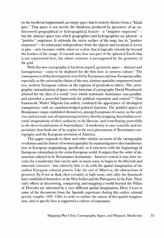
The cartography that emerged from the so-called cartographic revolution of the fifteenth through eighteenth centuries makes a powerful contribution to this central characteristic of modernity.' Its importance can be understood through a brief comparison between two maps, one medieval and the other early modern.2 Medieval mapmaking is perhaps best known for its mappaemundi, the traditional
depictions of the known world that graced the walls of cathedrals and the pages of illuminated manuscripts. This is the cartography of ecclesiastical mapmakers more interested in orienting the soul toward heaven than in directing the body through the physical world.3 As such, it is predicated upon a spatial armature that is best understood as a strategy for symbolizing the world rather than for representing it. That armature is best glimpsed in an incunabular printing of one of the earliest known examples from this tradition, the mappamundi that accompanies a 1472 edi- tion of the Etymologia of Saint Isidore of Seville (fig. 1). It depicts the known world,
REPRESENTATIONS 79 * Summer 2002 ? THE REGENTS OF THE UNIVERSITY OF CALIFORNIA
ISSN 0734-6018 pages 28-60. All rights reserved. Send requests for permission to reprint to Rights and Permissions, University of California Press,
28 Journals Division, 2000 Center St., Ste. 303, Berkeley, CA 94704-1223.
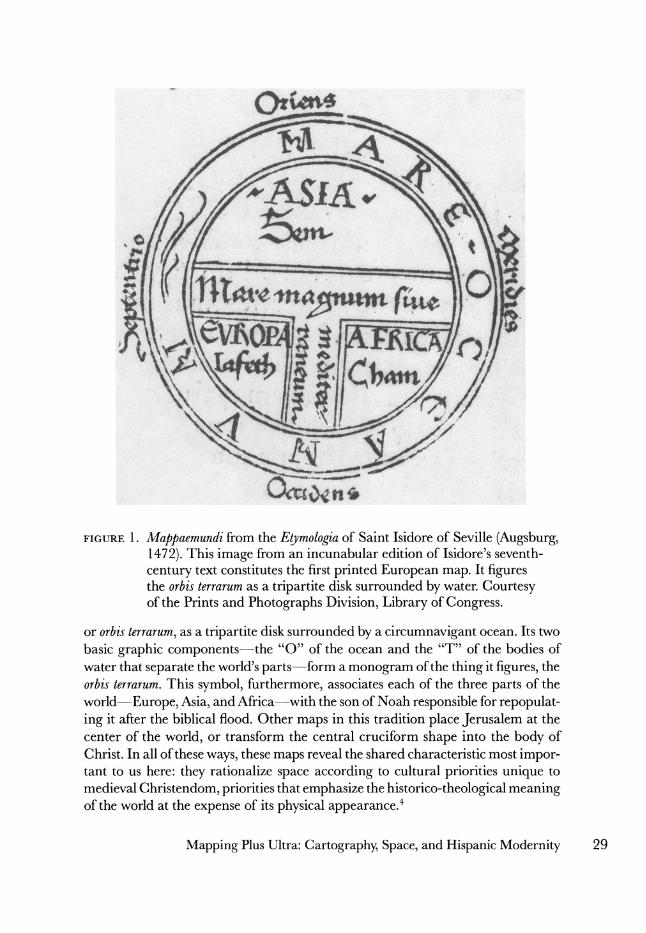
FIGURE 1. Mappaemundi from the Etymologia of Saint Isidore of Seville (Augsburg, 1472). This image from an incunabular edition of Isidore's seventh-
century text constitutes the first printed European map. It figures the orbis terrarum as a tripartite disk surrounded by water. Courtesy of the Prints and Photographs Division, Library of Congress.
or orbis terrarum, as a tripartite disk surrounded by a circumnavigant ocean. Its two basic graphic components-the "O" of the ocean and the "T" of the bodies of water that separate the world's parts-form a monogram of the thing it figures, the orbis terrarum. This symbol, furthermore, associates each of the three parts of the
world-Europe, Asia, and Africa-with the son of Noah responsible for repopulat- ing it after the biblical flood. Other maps in this tradition place Jerusalem at the center of the world, or transform the central cruciform shape into the body of Christ. In all of these ways, these maps reveal the shared characteristic most impor- tant to us here: they rationalize space according to cultural priorities unique to medieval Christendom, priorities that emphasize the historico-theological meaning of the world at the expense of its physical appearance.4
Mapping Plus Ultra: Cartography, Space, and Hispanic Modernity 29
Ot;rn4
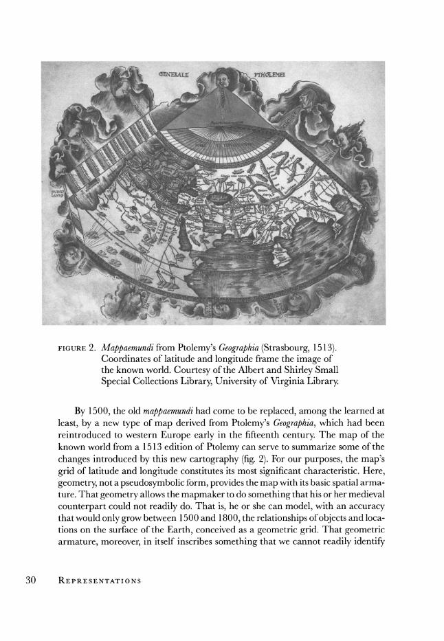
FIGURE 2. Mappaemundi from Ptolemy's Geographia (Strasbourg, 1513). Coordinates of latitude and longitude frame the image of the known world. Courtesy of the Albert and Shirley Small
Special Collections Library, University of Virginia Library.
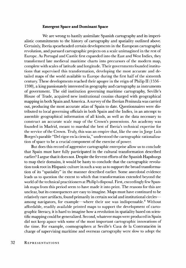
By 1500, the old mappaemundi had come to be replaced, among the learned at
least, by a new type of map derived from Ptolemy's Geographia, which had been reintroduced to western Europe early in the fifteenth century. The map of the known world from a 1513 edition of Ptolemy can serve to summarize some of the
changes introduced by this new cartography (fig. 2). For our purposes, the map's grid of latitude and longitude constitutes its most significant characteristic. Here, geometry, not a pseudosymbolic form, provides the map with its basic spatial arma- ture. That geometry allows the mapmaker to do something that his or her medieval
counterpart could not readily do. That is, he or she can model, with an accuracy that would only grow between 1500 and 1800, the relationships of objects and loca- tions on the surface of the Earth, conceived as a geometric grid. That geometric armature, moreover, in itself inscribes something that we cannot readily identify
30 REPRESENTATIONS
on the medieval mappaemundi, an empty space that is entirely distinct from a "blank
spot." That space is not merely the blankness produced by ignorance of an un- discovered geographical or hydrographical feature-a "negative emptiness"- but the abstract space into which geographies and hydrographies are plotted-a "positive" emptiness. It subtends the entire surface of the map, but its "positive emptiness"-its substantial independence from the objects and locations it serves to plot-only becomes visible when we realize that it logically extends far beyond the borders of the image. It extends into that vast part of the spherical Earth that is not represented here, but whose existence is presupposed by the geometry of the grid.
With this new cartography, it has been argued, geometric space-abstract and
homogeneous-came to be deployed for the first time in western culture.5 The
consequences of this development were felt by Europeans and non-Europeans alike, especially as the universalist claims of the new, abstract spatiality empowered mod-
ern, western European culture at the expense of premodern others. The carto-
graphic rationalization of space, writes historian of cartography David Woodward, allowed for the idea of a world "over which systematic dominance was possible, and provided a powerful framework for political expansion and control."6 That
framework, Walter Mignolo has added, combined the appearance of ideological transparency with an unacknowledged political function. The gridded spaces of Renaissance maps established themselves, among Europeans of course, as the only true and accurate way of representing territory, thereby stripping Amerindian terri- torial imaginations of their authority to do likewise, and contributing powerfully to the deterritorialization of Amerindians.7 A modernity at once scientific and im-
perialistic thus finds one of its origins in the twin phenomena of Renaissance car-
tography and the European invention of America. This paper responds to these and other similar accounts of the cartographic
revolution and the history of western spatiality by examining anew this transforma- tion in European mapmaking, specifically as it intersects with the beginnings of
European colonialism in the extra-European world. It argues that the order of ab- straction ushered in by Renaissance humanism-however central it may have be- come for a modernity that can be said, in many ways, to begin in the fifteenth and sixteenth centuries-has relatively little to do with the spatial imagination of the earliest European colonial powers. Like the owl of Minerva, the abstractions of
geometry fly, if not at dusk, then certainly at high noon, only after the Spaniards have established themselves in the West Indies and the Portuguese in the East. Their
early efforts at discovering, conquering, and mapping a world beyond the Pillars of Hercules are informed by a very different spatial imagination. Here, I turn to some of the documents from the Spanish experience during this earlier colonial
period, roughly 1492-1580, in order to outline the nature of this spatial imagina- tion, and to specify how it supported a culture of expansion.
Mapping Plus Ultra: Cartography, Space, and Hispanic Modernity 31
Emergent Space and Dominant Space
We are wrong to hastily assimilate Spanish cartography and its imperi- alistic commitments to the history of cartography and spatiality outlined above.
Certainly, Iberia spearheaded certain developments in the European cartographic revolution, and pursued cartographic projects on a scale unimagined in the rest of
Europe. As Portugal and Castile first expanded into the East and West Indies, they transformed late medieval maritime charts into precursors of the modern map, complete with scales of latitude and longitude. Their governments founded institu- tions that supervised this transformation, developing the most accurate and de- tailed maps of the world available to Europe during the first half of the sixteenth
century. These developments reached their apogee in the reign of Philip II (1556- 1598), a king passionately interested in geography and cartography as instruments of government. The old institution governing maritime cartography, Seville's House of Trade, acquired new institutional cousins charged with geographical mapping in both Spain and America. A survey of the Iberian Peninsula was carried
out, producing the most accurate atlas of Spain to date. Questionnaires were dis- tributed to local governing officials in both Spain and the Indies, in an attempt to assemble geographical information of all kinds, as well as the data necessary to construct an accurate scale map of the Crown's possessions. An academy was founded in Madrid, meant to marshal the best of Iberia's technical expertise for the service of the Crown. Truly, this was an empire that, like the one inJorge Luis
Borges's parable "Del rigor en la ciencia," understood the cartographic rationaliza- tion of space to be a crucial component of the exercise of power.
But does this record of aggressive cartographic enterprise allow us to conclude that Spain must have fully participated in the cultural transformation described earlier? I argue that it does not. Despite the fervent efforts of the Spanish Hapsburgs to map their domains, it would be hasty to conclude that the cartographic revolu- tion took root in Hispanic culture in such a way as to support the broad transforma- tion of its "spatiality" in the manner described earlier. Some anecdotal evidence leads us to question the extent to which that transformation extended beyond the world of the technical practitioners at Philip's disposal. First, exceedingly few Span- ish maps from this period seem to have made it into print. The reasons for this are
unclear, but its consequences are easy to imagine. Maps must have continued to be
relatively rare artifacts, found primarily in certain social and institutional circles--
among navigators, for example-where their use was indispensable.8 Without
affordable, readily available printed maps to support the development of carto-
graphic literacy, it is hard to imagine how a revolution in spatiality based on scien- tific mapping could be generalized. Second, whatever maps were produced in Spain did not keep apace with some of the most important cartographic innovations of the time. For example, cosmographers at Seville's Casa de la Contrataci6n in
charge of supervising maritime and overseas cartography were slow to adopt the
32 REPRESENTATIONS
crucial projection developed by Gerhard Mercator in the Protestant north. Finally, as Agustin Hernando points out, map production in Spain seems to have suffered a quantitative decline over the course of the seventeenth century. By century's end, Spanish intellectuals lamented that maps produced abroad were superior to Span- ish maps in every way.9 The geographer Sebastian Fernandez de Medrano refers to geography as a science belonging not to Spaniards, but to foreigners. "Tanto los
Principes, como sus subditos, politicos, y militares," he writes, "estan siempre sobre las Cartas," by contrast with their counterparts in Spain, who rarely used maps. His book, he explains, is meant to advance the sort of cartographic literacy typical of these countries, but so lacking in his own.10 Philip II seems to have planted seeds that did not take root, or that withered shortly after flowering.
The philological evidence tells a more striking tale about the extent of the spa- tial revolution in early modern Spain. It has been argued that the various Latin derivatives of the Latin spatium enter into general circulation only in the sixteenth and seventeenth centuries, and that this linguistic change is a measure of the in-
creasing importance of abstract space in European culture." In Spanish, the
eighteenth-century Diccionario de Autoridades registers an entry for espacio that sup- ports this contention. It defines espacio primarily as an abstract expanse, a definition consistent with the sort of space that structures the gridded maps of the Renais- sance. That definition, moreover, specifically attaches the general notion of espacio to the two-dimensional space of modern cartography: "ESPACIO. f. m. Capaci- dad, anchura, longitud 6 latitud de terreno, lugar, sitio, u campo. Es tomado del Latino Spatium, que significa esto mismo."'2 When we search for the word in six- teenth- and seventeenth-century Spanish texts, we find that espacio is used in this sense precisely where we would expect to find it, in the work of technically minded
professionals actively involved in either theoretical or applied cosmography. For
example, when such writers define such words as zone or climate, we find espacio used to refer to a two-dimensional expanse:
Es de notar que las seys lineas o siete espacios, que imaginamos en esta quarta habitable, no son iguales en Latitud, ni en Longitud unos con otros.... Y contrariamente en la Region donde en mucho spacio de tierra se variare o hubiera poca diferencia en el tiempo, alli un clima comprehendera mayor spacio de tierra ... 13
Ansi que se define el Clima ser un espacio de la Tierra, puesto entre dos Paralelos ... 14
Estas Zonas por la misma orden que dividen y cifien el cielo, dividen y cinen tambien la tierra en otras cinco partes correspondentes derechamente a cada una de las divisiones que las dichas Zonas, o Parallelos estan situados en el cielo, asi como una figura que en si es grande, toda ella se representa en muy mas pequefio cerco de un espejo ... desta manera e la tierra (muy mas pequefia que el cielo) se representan otros tantos espacios .. . 15
Clima es lo mismo que plaga, o region, y este es un espacio de tierra, la qual se incluye entre dos paralelos ... 16
Mapping Plus Ultra: Cartography, Space, and Hispanic Modernity 33
Zona es todo el espacio que se comprehende entre dos paralelos, y de estas se haze mencion de solas cinco, que son las siguientes ... 17
Sixteenth- and seventeenth-century texts written by Spaniards who were not
"cosmographers" of any kind, however, almost never exhibit this usage of the word
espacio. Even in highly literate forms of early modern Spanish, espacio was much more likely to be used, as it had been for many years, to refer to time rather than
space, in a manner similar to the modern despacio. The examples of this temporal definition in early modern Spanish usage are legion. It constitutes, for example, the most common sense of the word in Fernando de Rojas's classic, La Celestina
(1499-1502):
iQue spacio lleva la barbuda; menos sosiego trayan sus pies a la venida!'8
Da, sefior, alivio al coracon, que en poco spacio de tiempo no cabe gran bienaventuranca.19
0 spacioso relox, ain te vea yo arder en bivo huego de amor.20
A century later, Sebastian de Covarrubias's Tesoro de la lengua castellana o espanola (1611) registers only a vague spatial definition for espacio, one that simply reduces it to a synonym ofplace, and then quickly moves on to the temporal definition of the word: "ESPACIO. Del nombre latino SPATIUM, capedo, intervallum; vale lugar. Mucho espacio, poco espacio. 2. Tambien simplifica el intervalo de tiempo, y de- cimos por espacio de tiempo de tantas horas, etc."21 Even later, the Diccionario de Autoridades continues to recognize this temporal usage. It cites St. Teresa of Avila's Vida (1565): "Bien la puede representar delante de su imaginacion, y estarla mi- rando alguin espacio," as well as Juan de Mariana's Historia de Espana (1616): "Una
sequedad de la tierra y del aire, que continu6 por espacio de veinte y seis afios." We could also mention an example from Pedro Calder6n's El gran teatro del mundo (ca. 1634), which is fascinating in the way it clings to the temporal definition of the word even as the speaker invokes an optical regime that should, it seems, involve the emergent usage of the term:
Viendo estoy mis imperios dilatados mi majestad, mi gloria, mi grandeza, en cuya variada naturaleza perfeccion6 de espacio sus cuidados.22
When espacio was used to refer to space, it most commonly clung to the one-
dimensional, linear quality suggested by its temporal usage. This is true even in
cosmographical texts. For Geronimo de Girava, a Spanish resident of Milan and author of various, mostly derivative works on cosmography, espacio is more often
synonymous with distance rather than area. He explains, for example, how the an- cients traveled the distance between two places of known latitude and longitude and then "medieron el espacio de la Tierra que habian andado."23 In literary texts as well, it is the one-dimensional, linear usage that appears rather than the two-
34 REPRESENTATIONS
dimensional, planar sense. The usage in the second passage from La Celestina cited above, "poco spacio de tiempo," treats a temporal extension as if it were a space in which things do or do not fit. Later, in the same text, we read: "No aprenden los cursos naturales a rodearse sin orden, que a todos es un ygual curso, a todos un mesmo espacio para muerte y vida, un limitado termino a los secretos movimientos del alto firmamento celestial, de los planetas y norte, de los crecimientos y mengua de la menstrua luna."24 Here, the space through which bodies celestial and terres- trial move is a course, a linear progress from birth to death.
Other texts allow us to multiply the pertinent examples. In Francisco L6pez de Gomara's Historia general de las Indias (1552) we read: "Del rio de Palmas al rio Panuco hay mas de treinta leguas. Queda en este espacio Almeria."25 In Juan de Escalante's Itinerario de navegacion (1575); it is asked, "jPorque en tan poco espacio de camino como es este, he visto discordar a muchas personas ... ?,"26 In Part II of Alonso de Ercilla's La Araucana (1578), the two senses of espacio as "a length of time" and "a distance in space" are made to coincide in a fascinating rhetorical
figure:
Vuelto a la historia, digo que marchaba nuestro ordenado campo de manera que gran espacio en breve se alejaba del Talcaguano termino y ribera.27
In Don Quixote (1605), we read how one character rides to meet his companion: "Que un buen espacio de alli le estaba aguardando."28 Curiously, even the examples that Autoridades uses to support its spatial definition of espacio refer to this linear
imagination, rather than to the planar one that it pretends to identify in them. The
dictionary cites Fernando de Herrera's Anotaciones (1580): "Dividen los Pyreneos a Francia de Espafia, cortandola por espacio de casi ochenta leguas, del mar Mediter- raneo al Oceano Galico." It also cites Pedro de Espinel's Vida del escudero Marcos de
Obregdn (1618): "El espacio era poco, y en un instante corriendo nos pusimos en sus casas."
To recapitulate, only a small minority of early modern Spaniards seem to have used espacio to refer to a planar extension. For most Spaniards of this period, espacio continued to refer primarily to time, and secondarily to one-dimensional space, that is, distance. This brief philological discussion thus supports the conclusion sug- gested by the anecdotal evidence. The early modern revolution in mapping and
spatiality should be treated as an emergent trend located in a particular sector of the culture-a class of technical specialists-rather than as a widespread phenomenon involving the culture as a whole.29 If linguistic usage is any indicator of the way space was conceptualized, it was more common in early modern Spain to imagine space in linear, unidimensional terms rather than bidimensional, planar terms.30 But how does this unidimensional spatiality manifest itself? What kind of text can be said to imagine space as a line, rather than a plane? To answer this question, we
Mapping Plus Ultra: Cartography, Space, and Hispanic Modernity 35
must turn to a variety of texts, both discursive and cartographic, typical of this
spatiality that the cartographic revolution eventually consigned to the margins of the imagination of the west.
Beyond the Grid: Unidimensional Maps
The book written by Marco Polo in collaboration with the romance writer Rustichello da Pisa is usually thought of as a travel narrative. In fact, The Travels is the title given to at least one of its various English translations. Its original title, however, suggests that the book is something else. Divissament du monde suggests a descriptive, geographic piece, rather than a travel narrative. Why this change in title and, presumably, in genre? His book does indeed engage in a great deal of
description, particularly of the cities and provinces of Asia, but it links these descrip- tions together by making reference to the routes one would travel to get from one to the other. Thus we read, "After leaving the Province of which I have been speak- ing you come to a great Desert. In fact you ride for two days and a half continually down hill. On all this descent there is nothing worthy of mention except only there is a large place there where occasionally a great market is held ... After you have ridden those two days and a half down hill, you find yourself in a province towards the south which is pretty near to India, and this province is called Amien."31 In
this, Polo's book resembles other texts that circulated in late medieval and early modern Spain. They include the Itinerario of Ludovico Varthema (1510), the Itiner- arium ofJohn Mandeville (1496), the Andanfas e viajes of Pero Tafur (ca. 1436-1439), and the anonymous Libro del conoscimiento (ca. 1450). It also resembles geographical descriptions that appeared in a number of conquest chronicles, including the Suma de geografia of Fernandez de Enciso (1519), the Historia generaly natural de las Indias, Parts II and III, of Gonzalo Fernandez de Oviedo (ca. 1544), and the Historia general de las Indias of Francisco L6pez de G6mara (1552).
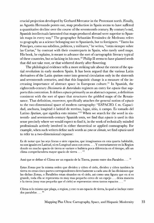
Marco Polo's book has a cartographic analogue in the itinerary map. Carto-
graphic representation, obviously, involves a number of choices on the part of the
mapmaker. He or she must decide which aspects of the territory to include, which to exclude, and how to handle the selected material. The maker of an itinerary map selects, from the many and varied aspects of the territory he or she wants to figure, privileged destinations and the routes that connect them as his or her chosen objects of representation. All other aspects of the territory-its general topography, pre- dominant kinds of vegetation, its aridity or humidity-are excluded. In making a
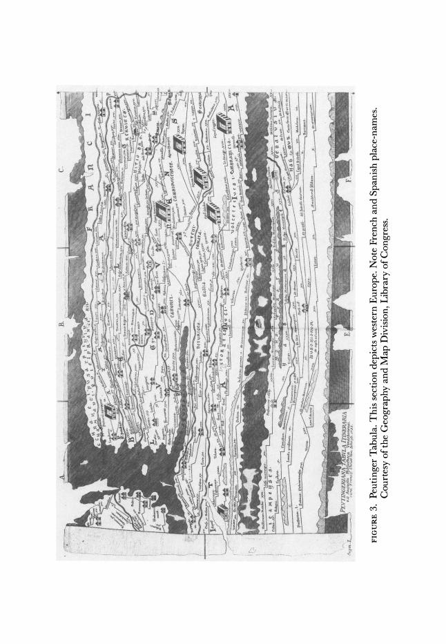
map like the Peutinger Tabula, the mapmaker then decides to treat the network of routes in a schematic fashion that facilitates its use, at the expense of sacrificing geographical realism. The result is something like a modern subway map, which suits perfectly the purpose of getting around on the subway, even though it does not accurately map the territory as a whole (fig. 3). The spatial relationships among
36 REPRESENTATIONS
A. C.
I' L X
P'- r
... .
.: " . . . . ..i -, --
,~;'"'lf~~~~) ' -" t o
C"n' A 4 e II 5 "C i
-'""..--'.:-.' ' ........
I I
F;I'? \'1... .....X' " '.-~Iiy. . . . F.. ....
FIGURE3. Peutinger Tabula. This section depicts western Europe. Note French and Spanish place-names. Courtesy of the Geography and Map Division, Library of Congress.
,,:,,.,,,:,.,,~.,,,.7 :,,,-~,,.,~ . ,E~ ,,::~ 1.:::~ . ,.,...,., ,~!,,~,-, v,,;:,,; .." -I-"- ~."? ~ i'. '~' . _ =: :,",~ }. ~.....
Courtesy
of the Geography and Map
Di~~~~~~~~~~~~~~vion LirarfCoges
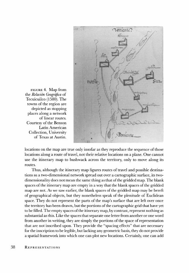
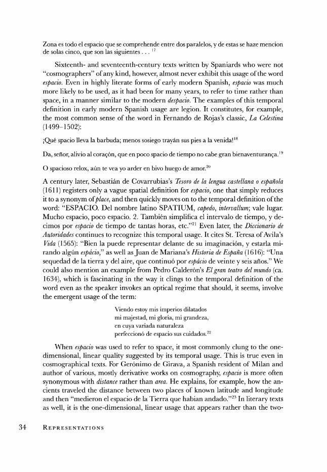
FIGURE4. Map from ) ? the Relaci4n Geograjica of Tecuicuilco (1580). The towns of the region are ,
depicted as stopping . NADP>et
places along a network of linear routes.
Courtesy of the Benson : i t Latin American .;
Collection, Universitya ,. r of Texas at Austin. Th blank
locations on the map are true only insofar as they reproduce the sequence of those locations along a route of travel, not their relative locations on a plane. One cannot use the itinerary map to bushwack across the territory, only to move along its routes.
Thus, although the itinerary map figures routes of travel and possible destina- tions as a two-dimensional network spread out over a cartographic surface, its two- dimensionality does not mean the same thing as that of the gridded map. The blank spaces of the itinerary map are empty in a way that the blank spaces of the gridded map are not. As we saw earlier, the blank spaces of the gridded map may be bereft of geographical objects, but they nonetheless speak of the plenitude of Euclidean
space. They do not represent the parts of the map's surface that are left over once the territory has been drawn, but the portions of the cartographic grid that have yet to be filled. The empty spaces of the itinerary map, by contrast, represent nothing as substantial as this. Like the spaces that separate one letter from another or one word from another in writing, they are simply the portions of the space of representation that are not inscribed upon. They provide the "spacing effects" that are necessary for the inscription to be legible, but lacking any geometric basis, they do not provide a spatial framework into which one can plot new locations. Certainly, one can add
38 REPRESENTATIONS
- '''.' i ' - " -- FIGURE 5. Map from
~'~:"< /;~i):- ,; .....,.~.,,?'t ,',,..,~'~.- the Relacidn Geogrdfica of /), _, ^ *Al ^~ ~Altatlauca-Malinaltepec
P . ' '
. , (1580). The towns of the
? ^.?b_.i;[ ? " region are depicted as
', ) .k,.. \ .,, stopping places along a L*,{l -- l' ,tt V l lnetwork of linear routes.
h~-^ ',n ~ Courtesy of the Benson
? Gs') &! L~ ~Latin American Collection, > ~n,~ .....~ ^University of Texas at
i-. ':L? Austin.
a road to the itinerary map, thereby cutting through this space and connecting locations that were not previously attached. In doing so, however, one is merely writing over one of the leftover bits of the original blankness, not plotting locations into a coordinate grid.
Such maps abounded in the early modern period. Some of them served as raw material for the fabrication of gridded maps. These will not concern us here. Oth-
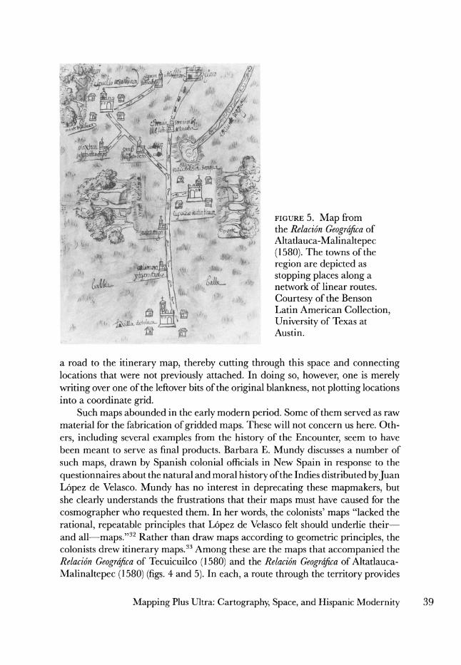
ers, including several examples from the history of the Encounter, seem to have been meant to serve as final products. Barbara E. Mundy discusses a number of such maps, drawn by Spanish colonial officials in New Spain in response to the
questionnaires about the natural and moral history of the Indies distributed byJuan L6pez de Velasco. Mundy has no interest in deprecating these mapmakers, but she clearly understands the frustrations that their maps must have caused for the
cosmographer who requested them. In her words, the colonists' maps "lacked the rational, repeatable principles that L6pez de Velasco felt should underlie their- and all-maps."32 Rather than draw maps according to geometric principles, the colonists drew itinerary maps.33 Among these are the maps that accompanied the Relacidn Geografica of Tecuicuilco (1580) and the Relacion Geografica of Altatlauca-
Malinaltepec (1580) (figs. 4 and 5). In each, a route through the territory provides
Mapping Plus Ultra: Cartography, Space, and Hispanic Modernity 39

- -7 *' Sto l -.'
,. ,^<8?e; .X4^4 ^ t . 3`r A ^^-^J^ ^/r IV
=^^ ^^~ur-rc~ ~y-^^ r ~suCL~:p"h~ ii r- C L
50r"'rcr~
FIGURE 6. Map of a portion of New Spain. Pedro Cortes (ca. 1550-1560). New Spain, northwest of the Viceregal capital, as a series of towns along a route of travel. Espafia. Ministerio de Educaci6n, Cultura y Deporte. Archivo General de Indias. MP Mexico, 8. Disefio o apunte de parte de la Nueva Espaia, desde Mexico hacia la Nueva Galicia, 1550-1560.
40 REPRESENTATIONS
e- OS c' -W
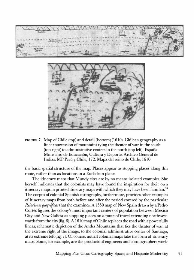
FIGURE 7. Map of Chile (top) and detail (bottom) (1610). Chilean geography as a linear succession of mountains tying the theater of war in the south
(top right) to administrative centers in the north (top left). Espafa. Ministerio de Educaci6n, Cultura y Deporte. Archivo General de Indias. MP Perui y Chile, 172. Mapa del reino de Chile, 1610.
the basic spatial structure of the map. Places appear as stopping places along this
route, rather than as locations in a Euclidean plane. The itinerary maps that Mundy cites are by no means isolated examples. She
herself indicates that the colonists may have found the inspiration for their own
itinerary maps in printed itinerary maps with which they may have been familiar.34 The corpus of colonial Spanish cartography, furthermore, provides other examples of itinerary maps from both before and after the period covered by the particular Relacionesgeograficas that she examines. A 1550 map of New Spain drawn by a Pedro Cortes figures the colony's most important centers of population between Mexico
City and New Galicia as stopping places on a route of travel extending northwest- wards from the city (fig. 6). A 1610 map of Chile replaces the road with a powerfully linear, schematic depiction of the Andes Mountains that ties the theater of war, at the extreme right of the image, to the colonial administrative center of Santiago, at its extreme left (fig. 7). Of course, not all colonial maps take the form of itinerary maps. Some, for example, are the products of engineers and cosmographers work-
Mapping Plus Ultra: Cartography, Space, and Hispanic Modernity 41
ing in the field, so to speak, and demonstrate the technical sophistication that one would expect from such professionals. Itinerary maps nonetheless form part of the
corpus, and tell us something about the spatial and cartographic imagination of the field agents that produced them.
One might protest that travel narratives, itinerary maps, and nautical charts
represent maps of a particular class-so-called way-finding maps-that primarily serve the purpose of "getting there," rather than of conceptualizing space or figur- ing geographical knowledge. Such maps are very important to anthropologists, particularly those interested in the spatial imagination of nonwestern cultures in which way-finding maps may be the only kind of map in circulation. In the history of western cartography, way-finding maps, particularly nautical charts, constitute an important object of study in their own right. Rarely, however, do they impinge on histories of western spatiality, where the more theoretical cartography of the learned is left to glitter all on its own. Mignolo, for example, sets aside way-finding maps in his discussion of early modern European spatiality. As he explains, "These
maps," referring to the nautical charts of the Casa de la Contrataci6n, "do not
conceptualize the Indies so much as the coastlines hitherto unknown to west ern
Europe."35 It seems that one would never confuse practical maps like these-be
they sixteenth-century nautical charts, contemporary maps of subway systems, or the sketch maps that our friends provide us so that we can get to their homes- with maps of a more scientific nature. The scale map and its spatiality serve as
synecdoches for the cartography and the spatiality of the culture as a whole, while the way-finding map can be consigned to the category of second-order cartographic products, and therefore left abandoned by any further discussion of spatiality.36
This kind of approach imposes upon the past the cartographic culture of the
present, the very cartographic culture, in fact, that was coming into being during the early modern period. Medieval mapmaking was a thoroughly heterogeneous enterprise. Different communities made different kinds of maps for different cir- cumstances. Although these various strands of mapmaking could intersect and even blend at times, one cannot point to a shared idiom that united these various types of mapmaking into a unified cartographic science.37 The cartographic revolution
changed this, not just because it introduced geometrically rationalized maps where before there had been none, but because it established one type of map as the hege- monic kind. It introduced something that the Middle Ages lacked, a cartographic idiom consciously asserted as a flexible means of mapping the surface of the earth at any scale, from the largest to the smallest. It was an idiom that had at its disposal crucial technologies of reproduction and dissemination that were not available be-
fore, as well as increasing institutional support from governments, universities, and the like. These factors combined to guarantee that the cartography of the learned could extend out from its original social location among Renaissance humanists into other sectors of the culture in a way that no individual type of medieval map could.38 The resultant hegemony of the gridded map came to be reflected by linguis-
42 REPRESENTATIONS
tic usage. During the sixteenth century derivatives of the Latin word mappa began to circulate widely for the first time, and they came to be associated specifically with the geometrical techniques of Renaissance cartography. Just as it defined espacio
primarily as the two-dimensional space of modern cartography, the Diccionario de Autoridades defines mapa in terms that clearly associate it with the geometry of the
gridded map:
MAPA. f. amb. La descripci6n geographica de la tierra, que regularmente se hace en papel 6 lienzo, en que se ponen los lugares, mares, rios, montafias, otras cosas notables, con las distancias proporcionadas, segun el pitipie que se elige, sefialando los grados de longitfid y latitid que ocupa el Pais que se describe, para conocimiento del parage 6 lugar que cada cosa destas ocupa en la tierra.39
One of the examples cited in support of this definition, taken from Christoval de Fonseca's Vida de Christo (1601), specifically mentions a cosmographer as the maker of a map: "Quando un Cosm6grapho saca un mapa general de Espafia, 6 de todo el mundo, pone alli las principales cosas del." Here, then, we see institutionalized an association of mapping with geometry and the correct potrayal of the surface of the Earth that would remain all but unchallenged until recent years. It is an association that leads English users to refer to their own itinerary maps-the sort of thing one draws so that a friend can find one's house-as a "sketch-map," and
Spanish speakers to use the term croquis. Both usages acknowledge the hegemony of a scientific cartography, a type of mapmaking that lays sole claim to the produc- tion of "real" maps.
Lately,J. Brian Harley has proposed a new definition: "Maps are graphic repre- sentations that facilitate a spatial understanding of things, concepts, conditions, processes, or events in the human world."40 Two things have disappeared from this definition: 1) specific mention of the particular cartographic idiom that has domi- nated western cartography since the rediscovery of Ptolemy's Geography; and 2) spe- cific mention of the surface of the Earth as the referent of the map. The word "map" has thus been cut free from its association with a particular type of mapmaking that has been hegemonic in a particular culture at a particular time, and has been
opened up to include "maps" of many different kinds, from many different places and times. The new definition acknowledges that cartographic idioms, both in their referents and in their figurative strategies, are culturally and historically contin-
gent, and that they share only two characteristics, that of being "graphic" and that of being "spatial." These terms, furthermore, are left unspecified, allowing us to include graphic representation of different kinds, that embody different forms of
"spatiality." This new openness in the definition of the map has been crucial for those histo-
rians interested in the spatial and territorial elements of the history of the Encoun- ter. Older definitions of the map tended to recognize only western, scientific maps as "true" representations of territory, and consigned alternative cartographies- specifically nonwestern ones-to an exotic fringe. Mignolo, in his own attempts to
Mapping Plus Ultra: Cartography, Space, and Hispanic Modernity 43
free historical discourse from the hegemony of the gridded map, tries to undermine this bias by proposing that we speak, not of "maps," but of "territorial representa- tions." Like Harley's definition, this category is open to different determinations of what constitutes a "territory" and how it can be rendered in graphic form. It is meant to be inclusive, and to place such artifacts as Mexican pinturas on a level
playing field with European maps. In this way, the story ofterritorialization so cen- tral to the history of the 1492 Encounter comes to be understood as a confrontation between different, incommensurable territorial imaginations, each one expressed in its own graphic idiom, rather than as the substitution of primitive mapping with scientific cartography.41 I believe that we should now refine this argument by replac- ing its binary opposition of Amerindian and European territorial imaginations with a tertiary one that recognizes change and diversity in the European side of the equation. The Encounter does not stage a clash between an Amerindian, ethnic rationalization of space and a European, geometric rationalization, but between an Amerindian imagination (I will leave it to others, better prepared to do so than
I, to question the validity of the singular here) and a European imagination caught in a process of transformation from one stage to another.
In order to flesh out this tertiary opposition, we need to flesh out how the linear, unidimensional spatiality of early modern espacio, of travel narrative, of itinerary maps, and of nautical charts constitutes a "spatiality" comparable to the planar espacio of the gridded map. Let us return for a moment to Marco Polo. John Larner
points out that "anyone who approaches the work [the book of Marco Polo] looking for a tale of heroic exploration is going to be badly disappointed. Nothing is more
striking here than Marco's silence about the difficulties and dangers he must have faced or about the character of the journeys he made."42 Later, he argues that "These supposed itineraries, alas, are fantasies . . . this is clearly not the route of the Polos through Asia; it is an organizational device, the route along which Marco and Rustichello lead their readers from west to east and back from east to west, the route through the Book."43 Finally, Larner asserts that the text is not really travel narrative at all, but "simply and essentially a work of geography."44 I agree that the
purpose of Polo's book is primarily geographical exposition-not travel narrative in our sense-but I do not think that this interpretation requires us to reduce Polo's use of the itinerary to the status of a mere "organizational device." That skeletal travel narrative, like any skeleton, may be bare-bones, but it is not superficial. Con- sider the following example:
Now, we will quit this country. I shall not, however, now go on to tell you about India; but when time and place shall suit we shall come round from the north and tell you about it. For the present, let us return by another road to the aforesaid city of Kerman, for we cannot get at those countries that I wish to tell you about except through that city.... On the road by which we return from Hormos to Kerman you meet with some very fine plains, and you also find many natural hot baths.... Now, then, I am going to tell you about the countries towards the north, of which you shall hear in regular order.45
44 REPRESENTATIONS
Why should the narrator need to backtrack to a city previously described in order to push his description forward? Why not simply describe the next place, whether it be to the north or the south? While Marco Polo's text may not tell of the hazards and impressions of the journey, it does not entirely forget the limitations of the flesh- and-blood traveler. The result is something richer than what Larner identifies. This is not just geography organized as a textual itinerary, but geography organized as
ajourney, as a linear movement through space organized as a route of travel, albeit a fictive one. By reminding us, at this point, that we need to backtrack to a particu- lar node in a network if we wish to move in a certain direction, the discourse invites us to relate to the territory from a particular point of view. It interpelates the reader, not as an onlooker looking down on the territory from a height, as in a map, but as a traveler, moving through that territory, place by place, along routes.
The difference between this point of view and that of the Renaissance map could not be more dramatic. It has been said that the change wrought in European cartography by the Renaissance cartographic revolution is best understood, not as an extension of European horizons, but as an elevation of the point of view from which an implied, European observer views the world. The modern map does not
just grid the world, it puts it on display for consumption by an onlooker who has been abstracted from the world he or she inhabits, who has been raised to a com-
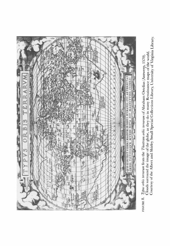
manding height.46 Hence the tendency of many Renaissance mappaemundi to frame the world with clouds, or heads representing the various winds. Such devices have the effect of opposing the terraqueous globe and the map reader as an object in space, and a privileged onlooker gazing at it from above. They give explicit iconographic form to the optical regime implicit in any gridded map (fig. 8). Polo's insistence
upon the "reality" of his route of travel, inscribed in this reminder of the limitations felt by bodies moving across space, brings the reader down to earth. It reminds him that the text he is reading constitutes a tour through a territory, not a figure of it to be perceived from a Mennipean height.
We are mistaken, furthermore, if we consign this way of rationalizing space to the margins of the culture, and save the center for "real" maps, of whatever kind, that do not depend on travel for their organizational strategy. Polo and the other "travel" writers I mentioned, the authors of our colonial itinerary maps, may in fact be heirs to a spatial imagination long established in the culture of the Mediter-
ranean, and recently rediscovered by the Italian classicist PietroJanni. In La mappa e ilperiplo, Janni has thought to contradict the established wisdom about cartogra- phy in the ancient Mediterranean world. Very few ancient maps have survived to our day, requiring us to infer what they must have been like from texts of other kinds, such as discursive geographies and historiography. Janni argues that the in- ferences made from these texts by his fellow classicists have been fundamentally misguided. That scholarship tends, for example, to infer that lengthy geographical descriptions, like those of Strabo or Pomponius Mela, would have come accompa- nied by maps, or at least that they demonstrate a certain amount of cartographic
Mapping Plus Ultra: Cartography, Space, and Hispanic Modernity 45
?L~~~~~~~~~~ I t c t _<*- Wk~~~~~~~Y | if E) I Y) `7 t) 'F [S I T r
Pf i
~~~~~~~"~~~~~'~
'
'f" t"
RE rX - - T--- -
f '~~~~~~~~~~~~~~~~~~~' :'. :t^ >'.rr ' l _ . . . . . . r , _- 4 .. '
f f -'QSII EI'(T.SVI)EI.A(VMNED.SHVstN'S.\ 1)E ' EST VI1 P MAGNV .EB I AAN '.CrJETERNITAS1 w=;< _
;o is. i ri N.S VE ,x"N....DI N~ T -A - I :, MA ,N I T V -. 0,r (': CE R 0,
_fwt
s3
SI -- 5
FIGURE 8. Typus orbis terrarum from the Theatrum orb'strau of Abraham Ortelius (Antwerp, 1570). Clouds surround the image of the globe, as they do in many Renaissance maps of the world. Courtesy of the Albert and Shirley Small Special Collections Library, University of Virginia Library.
/I ~ ~ ~ ~ ~ ~ ~ ~ ~ ~ ~~~:
//~~~~~~~~~~' ',
., I?' i, ~ ~ ~ yDEPTE~ VIDER. MA;~Vh IN~.BV. HV A $ C ATERIA
;~,~ O~.lS TOF S.V MVNDIN'AITIAiTV.CCE'
-..i~~~~~u '~~cr
literacy in the culture that produced and consumed them. It also tends to translate words that refer to different kinds of geographical descriptions as map or chart, and
thereby reach generous conclusions about map-use in antiquity. Janni argues that these inferences ignore the many crucial stumbling blocks presented by geographi- cal language itself, and thereby mistakenly project onto antiquity a sort of carto-
graphic culture that it did not have. Strabo, for example, uses a language of move- ment and orientation in his descriptions that do not easily translate into
cartographic form. Janni thus advocates a more conservative treatment of classical
geographical discourse, one that leads to a very different assessment of "ancient
cartography." Map-use, he argues, was not widespread in antiquity, and neither was the tendency to imagine the world through the two-dimensional spatiality of the map. The predominant spatial imagination of the Greco-Roman world was
actually quite different from that of the modern west, in that it tended to imagine the world through the unidimensional spatiality of the itinerary or periplus, rather than the two-dimensional one of the map. The ancients, in this sense, can be consid- ered a precartographic, or noncartographic culture.47
Whether or not Janni is right about the ancients, the sort of spatiality he is
describing is clearly in evidence in early modern Spain, and well into the sixteenth
century. Consider the following passage from Fernando Colon's Descripciony cosmo-
grafia de Espana (1517):
Toledo es cibdad de 18000 vecinos esta en unas cabezas de cerros e valles e entre unas syerras en hondo e tiene buenas alcazares cerca el rio dicho taxo ... Toledo e fasta burguillos ay legua e media de cerros e cuestas arriba e en saliendo pasamos a taxo por puente que corre a la mano derecha e fasta xofira ay tres leguas e van por burguillos e fasta mazaram- bron ay tres leguas de cerros grandes e cuestas e en saliendo pasamos el dicho rio que corre a la mano derecha.48
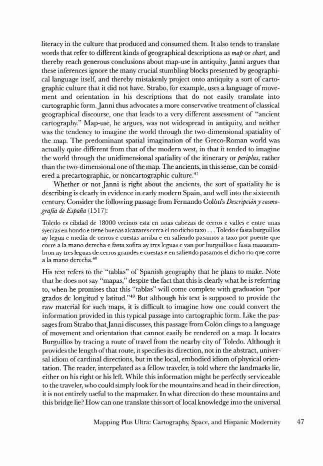
His text refers to the "tablas" of Spanish geography that he plans to make. Note that he does not say "mapas," despite the fact that this is clearly what he is referring to, when he promises that this "tablas" will come complete with graduation "por grados de longitud y latitud."49 But although his text is supposed to provide the raw material for such maps, it is difficult to imagine how one could convert the information provided in this typical passage into cartographic form. Like the pas- sages from Strabo thatJanni discusses, this passage from Colon clings to a language of movement and orientation that cannot easily be rendered on a map. It locates
Burguillos by tracing a route of travel from the nearby city of Toledo. Although it
provides the length of that route, it specifies its direction, not in the abstract, univer- sal idiom of cardinal directions, but in the local, embodied idiom of physical orien- tation. The reader, interpelated as a fellow traveler, is told where the landmarks lie, either on his right or his left. While this information might be perfectly serviceable to the traveler, who could simply look for the mountains and head in their direction, it is not entirely useful to the mapmaker. In what direction do these mountains and this bridge lie? How can one translate this sort of local knowledge into the universal
Mapping Plus Ultra: Cartography, Space, and Hispanic Modernity 47
knowledge of a map? Territory here is conceptualized in and through travel, in
ways that resist their representation in the new cartographic language of the grid- ded map. We can assume that Colon does this-and perhaps that the colonial map- makers cited above do the same-not because their perception of territory is struc- tured by travel as an individual experience, but because it is structured by travel as a universal idiom. This is the idiom that serves to figure territory in the absence of a
fully deployed cartographic and spatial alternative. That alternative, however, was in the making. Janni, like other historians, iden-
tifies the early modern period as a crucial nexus in the history of space in the West, but since his interpretation of what came before this period is more radical than that of others, so his brief mention of early modern mapping has deeper implica- tions. For Janni, the early modern cartographic revolution does not just bring im-
portant changes in the way maps were made: it accomplishes a deeper transforma- tion of the culture from a premodern, precartographic stage to a modern, cartographic one. With the map comes space itself. And, for him, the map in ques- tion is not primarily the gridded map, but another way-finding map, the nautical
chart, especially as it was adapted to suit the needs of astronomical navigation.50 This adaptation was originally the work of Portuguese mapmakers, but they were soon followed by their Spanish counterparts. The story of the nautical chart thus leads inevitably to Iberia, and, as we shall see, it complicates the simple opposition of linear versus planar, premodern versus modern that has governed the discussion so far.
The European nautical chart has its roots in the late medieval "portolan chart," a cartographic technology that came into use in the Mediterranean world along with the compass. The portolan chart, in turn, may have been a successor to an
earlier, purely discursive rather than iconographic form, the portolano.5l Portolanos are verbal descriptions of the prominent features of a coastline, meant to facilitate
navigation that tended to move from one point to another generally without losing sight of the coast. The introduction of the compass led to the transformation of these
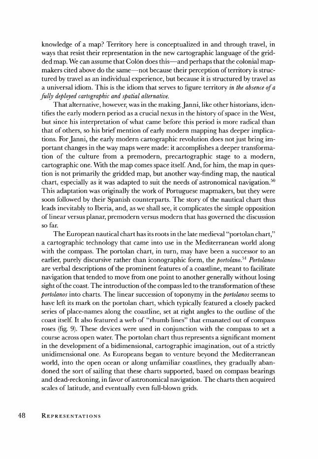
portolanos into charts. The linear succession of toponymy in the portolanos seems to have left its mark on the portolan chart, which typically featured a closely packed series of place-names along the coastline, set at right angles to the outline of the coast itself. It also featured a web of "rhumb lines" that emanated out of compass roses (fig. 9). These devices were used in conjunction with the compass to set a course across open water. The portolan chart thus represents a significant moment in the development of a bidimensional, cartographic imagination, out of a strictly unidimensional one. As Europeans began to venture beyond the Mediterranean
world, into the open ocean or along unfamiliar coastlines, they gradually aban- doned the sort of sailing that these charts supported, based on compass bearings and dead-reckoning, in favor of astronomical navigation. The charts then acquired scales of latitude, and eventually even full-blown grids.
48 REPRESENTATIONS
FIGURE 9. Mediterranean and western Europe. Mateo Prunes (Majorca, 1559). This sixteenth-century chart is a worthy successor to the tradition of portolan chart-making that flourished in late medieval Catalonia. Notice its compass roses, rhumb lines, and dense rows of place-names set at right angles to the outline of the coast. The ornate decoration is typical of Catalan charts. Courtesy of the Geography and Map Division, Library of Congress.
For Janni, these technological changes required a cognitive leap on the part of the navigator that sealed the shift from a unidimensional to a two-dimensional
spatiality that had begun with the portolan chart:
Navigazione d'altura significa un nuovo senso della bidimensionalita della superficie terres- tre: essa sta alla carta come la navigazione costiera sta al periplo. Per navigare lungo costa bastava 1'elenco dei porti, delle distanze, con qualche indicazione di direzione qua e la, come un di piu; ora, por attraversare i mari e per arrivare non troppo lontano dal punto giusto, occorre una rotta, un azimuth, cose che si collocano non piu lungo una linea, ma su una superficie.52
Frank Lestringant concurs. He reminds us that the ocean is "an abstract place ... without shape or points of reference."53 More than any other part of the earth's surface, it seems to resemble the trackless expanses of an empty cartographic grid, and thus lends itself well to geometric rationalization. There, in the ocean, "devoid of relief or definite colour and without any boundaries or routes ... cosmographical theory and the concrete experience of the navigator coincided."54 Lestringant cites Pedro de Medina, who wrote of the sea in precisely these terms. He calls it "una cosa tan larga y espaciosa como es la mar donde ni hay camino ni serial de el."55 In Medina's espacioso, Euclidean geometry comes down to Earth, so to speak, to coincide with its material cousin, the ocean. There, on a surface at once Euclidean and physical, the navigator could effect the leap from a unidimensional conceptual- ization of space to a two-dimensional one that was much more difficult for his land- lubber counterparts.
Sadly, however, this happy tale of reconciliation between the abstract and the concrete on the high seas runs into the shoals of various historical particularities. Although Medina may wonder at the spaciousness of the sea, he does so only to
praise the art of navigation, which makes it possible to domesticate this spacious- ness, to find routes where there are apparently none. Here is his remark again, placed back into its context:
Quien basta a decir una sutileza tan grande que un hombre con un compas y unas rayas sefialadas en una carta sepa rodear el Mundo, y sepa de dia y de noche a d6nde se ha de allegar, y de d6nde se ha de apartar y cuanto ha de andar a una parta o otra y que acierte a caminar por una cosa tan larga y espaciosa como es la mar, donde ni hay camino ni sefial de el, por cierto cosa es muy sutil y dificultosa; y asi considerada por Salom6n, dice que una de las cosas mas dificiles de hallar es el camino de la nave por la mar, porque ni sigue camino ni deja seial.56
The reference to Solomon-the Book of Wisdom-leaves little doubt that the spa- ciousness and tracklessness of the sea is an object of dread. In the biblical text to which he alludes, the traceless passing of a ship at sea becomes a figure for the oblivion to which human vanity is destined.57 Navigation, remarkably, conquers this powerful figure of oblivion by finding in it the routes that it does not seem to have. Those routes are in fact there, in the form of prevailing currents and winds that favor the passage of sailing vessels one way rather than another. It was Medina's
50 REPRESENTATIONS
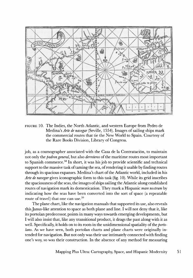
FIGURE 10. The Indies, the North Atlantic, and western Europe from Pedro de Medina's Arte de navegar (Seville, 1554). Images of sailing ships mark the commercial routes that tie the New World to Spain. Courtesy of the Rare Books Division, Library of Congress.
job, as a cosmographer associated with the Casa de la Contrataci6n, to maintain not only the padron general, but also derroteros of the maritime routes most important to Spanish commerce.58 In short, it was his job to provide scientific and technical
support to the massive task of taming the sea, of rendering it usable by finding routes
through its spacious expanses. Medina's chart of the Atlantic world, included in his Arte de navegar gives iconographic form to this task (fig. 10). While its grid inscribes the spaciousness of the seas, the images of ships sailing the Atlantic along established routes of navigation mark its domestication. They mark a Hispanic mare nostrum by indicating how the seas have been converted into the sort of space (a repeatable route of travel) that one can use.59
The plane chart, like the navigation manuals that supported its use, also reveals thisJanus-like attention to space as both plane and line. I will not deny that it, like its portolan predecessor, points in many ways towards emerging developments, but I will also insist that, like any transitional product, it drags the past along with it as well. Specifically, it holds on to its roots in the unidimensional spatiality of the porto- lano. As we have seen, both portolan charts and plane charts were originally in- tended for navigation. But not only was their use intimately connected with finding one's way, so was their construction. In the absence of any method for measuring
Mapping Plus Ultra: Cartography, Space, and Hispanic Modernity 51
longitude at sea, newly discovered lands could only be plotted onto the chart by correlating their latitude with their distance and direction from a known location.
Indeed, even the position of the ship itself, when a known coastline was not in sight, could only be determined using this method. The use of both portolan and plane charts was thus intimately connected with itineraries of travel, and depended on the skills of pilots with deep experience in the art of dead reckoning, the art of
estimating speed and distance. This is the cartographic technology that voyages of
exploration took with them, and that they used to chart the newly discovered coasts of the Indies.
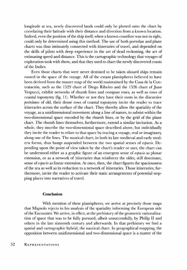
Even those charts that were never destined to be taken aboard ships remain rooted in the space of the voyage. All of the extant planispheres believed to have been derived from the master map of the world maintained by the Casa de la Con-
trataci6n, such as the 1529 chart of Diego Ribeiro and the 1526 chart of Juan Vespucci, exhibit networks of rhumb lines and compass roses, as well as rows of coastal toponymy (fig. 11). Whether or not they have their roots in the discursive
portolanos of old, their dense rows of coastal toponymy invite the reader to trace itineraries across the surface of the chart. They thereby allow the spatiality of the
voyage, as a unidimensional movement along a line of names, to subsist within the two-dimensional space encoded by the rhumb lines, or by the grid of the plane chart. The rhumb lines themselves, furthermore, extend a similar invitation. As a
whole, they inscribe the two-dimensional space described above, but individually they invite the reader to relate to that space by tracing a voyage, real or imaginary, along one of the lines. The nautical chart, in both its late medieval and early mod- ern forms, thus hangs suspended between the two spatial senses of espacio. De-
pending upon the point of view taken by the chart's reader or user, the chart can be understood either as a graphic figure of an emergent sense of espacio as planar extension, or as a network of itineraries that reinforces the older, still dominant, sense of espacio as linear extension. At once, then, the chart figures the spaciousness of the sea as well as its reduction to a network of itineraries. Those itineraries, fur-
thermore, invite the reader to activate their static arrangements of potential stop- ping places into narratives of travel.
Conclusion
With mention of these planispheres, we arrive at precisely those maps that Mignolo rejects in his analysis of the spatiality informing the European side of the Encounter. We arrive, in effect, at the prehistory of the geometric rationaliza- tion of space that was to be fully pursued, albeit unsuccessfully, by Philip II and others in the late sixteenth century and afterwards. In that prehistory we find a
spatial and cartographic hybrid, the nautical chart. In geographical mapping, the
opposition between unidimensional and two-dimensional space is a matter of the
52 REPRESENTATIONS
In. c xo t lcublcrto flfti .1 2J ri?o',i co ol ] P0 V P \'NtI 1ARCTIC I Y \ .' OCkANV SEPTETRJ
t^lB^T^ t -^?-& ''^ ^^y ct?, /^^ '^ ^ MAKF HYPFAROPEV'.
T DF vC Z. !
1VA_ .- ? r
.
T .
.
! , ;
,.t ip r~~lr L~~~~~~~~~~~RA l)t t; s ~I ~1 PI ; n
'-i. : ^,:':"',",' . . . -. .. ' * ~,
...... ?\-' '.a^.'. :.:':_ :. . . 't F R.,:
W^*EOA . :, . *.l-.'EI, -
^.. /^ ;-.., TV. ,
t? \ *,~- \ >" . ' " , ' ' -., , t *' -. . -:::"s'-1
'
N.... . . ^ . y ir. 0d t
.... -, o .... . .. . ivo.. L r C n gre. *?- -- t- - ( ofF to v . /--...
"44,' .<-,1 ;'
-
; ..,- .- j *
j^^ -~ r~;^^ "^.^ -~~\tf '
; ~;; ;.
t.O *, _7
" '"^ .
._s . ... . . _- ...... , ,
.. . _ _. , _ .......... _ * - r . r.
f
iR. A t'-,t' l i* t ^^ ^^
'1 *!'J?*1 11<A1 - ^y^I
-- ^f^ - V.> rCii\NM\"niA rIA CTICVS: j .-'
i aoln QiucFi;tcro iilo6 Q px C.
FIGURE 11. Detail from planisphere. Diego Ribeiro (Seville, 1529). From a facsimile by W. Griggs, 1886. Original in the Museum of the "Propaganda" in Rome. A dotted line bisecting the image vertically provides the chart with its scale of latitude. Faint grid lines are also visible. Courtesy of the Geography and Map Division, Library of Congress.
relationship between two different cartographic forms-professional gridded maps and amateur itineraries-that can be located, more or less, in different social
spaces. Its history suggests that, despite the continued presence of the itinerary on the cultural stage, the map must eventually triumph over it, consigning it to the diminished status of derivative, secondary, "merely" way-finding cartographic products. The maritime chart, by contrast, suggests a different approach. As a
highly rationalized cartographic product that retains its connection with way- finding, as a map that figures space in and through the itineraries that serve to
experience and construct it, the chart seems to internalize that opposition between
plane and line, and to place the two into a creative tension. In it, our two senses of
space coexist on a single cartographic surface, a single chart, that comes to be pro- duced and used by both highly literate mapmakers and the most illiterate mariners. As the hybrid product of a transitional historical moment, the nautical chart re- minds us that the social groups and spatialities that we have traced so far were not
always so neatly compartmentalized. It also suggests that the history of spatiality in this period must be understood in terms of the give-and-take between two ten-
dencies, a give-and-take that can manifest itself even within the confines of a single text. The history of spatiality, and of its contributions to the origins of those empires that would only later be rationalized on the surfaces of gridded maps, is a story that has yet to be told.
That spatiality, it should be stressed, was not unique to Spanish culture. Most of the crucial cartographic innovations I have mentioned-the use of a scale of latitude on a maritime chart, for example-were borrowed from the Portuguese. These innovations were also adopted by other burgeoning maritime powers eager to rival the early achievements of the Iberians. Charts with rhumb lines, for exam-
ple, were used in France, in England, and elsewhere throughout the sixteenth cen-
tury. A quick glance at the Oxford English Dictionary, furthermore, suggests that the use of these charts may have been accompanied by an understanding of space simi- lar to the one I have outlined: space in early modern English mirrors the meanings of espacio in the Spanish of the time. The Hispanic context, however, offers unique opportunities for studying alternative cartographic and spatial imaginations in the
relatively large body of maps made by cartographic "amateurs," so to speak, drawn in response to the demands of imperial governance and preserved today in archives in Europe and the Americas. We have seen a few of these maps earlier. That context, moreover, becomes increasingly distinct from the rest of Europe as the sixteenth
century yields to the seventeenth. As we have seen, Spanish cartography seems to have been left behind by the history of the map in northern Europe, where maps were more likely to reach print, and to be built upon the latest cartographic projec- tions. In this way, a spatiality that was once common to all of western Europe gradu- ally becomes uniquely Spanish, or uniquely Iberian or Mediterranean, as the map, abstract space, and modernity itself take root in northern Europe, leaving the south behind. It would not be until the eighteenth century, when a fully modern spatiality
54 REPRESENTATIONS
held sway in the north, and a French dynasty had come to power in Madrid, that
Spain would make a concerted effort to modernize its maps and its cartographic institutions.
The story of this spatiality may have few consequences for our understanding of the ways that non-Europeans suffered through the expansion of the west into the nonwest. Colonization, deterritorialization, destructuration, transculturation-all of these things probably look the same to the colonized other, regardless of whether or not the colonizer has learned to think about space in terms of abstract spaces rather than linear distances. That is, of course, unless the order of abstraction em-
powers the colonizer in ways that enhance the effectiveness of colonial rule. The
history of the map in the centuries following 1580 certainly suggests that it does. Those centuries witnessed the continued refinement of European mapping tech-
niques and the ongoing development of state-sponsored cartographic institutions
along with the growth of both the nation-state and the transnational empire. They also witnessed the ever-increasing dissemination of printed, scale maps throughout the world of the European powers. With the increasing availability and authority of the map, as we have come to know it, the territorial imaginations of colonial others increasingly began to experience the ideological colonization of the order of
abstraction, and eventually fell out of public discourse almost entirely. But this very hegemony of the map in our own times-its inextricable associa-
tion with a highly naturalized notion of "space" as isotropic extension and its
equally close affiliation with the spaces of the nation and the empire-makes it all the more urgent to rediscover the spatialities of the past. If nothing else, we find that the modernity from which we are just emerging, or at least one aspect of that
modernity, was not produced by the abstract imagination of the mapmaker, the
surveyor, the planner, the architect, and the like. Their representations of space, at their origins, begin to look like urgent attempts to apprehend and manage a wide world that had been brought into being by a very different culture of time and
space. In so many ways the early maritime empires of Spain and Portugal were
products of their medieval past. The rhetoric of crusading Reconquest, of chivalry, of universal Christian empire-all medieval inheritances-informed many of the
ways Iberians imagined those empires. So too did a spatial imagination that clung to the itineraries of late medieval travel, turning to geometry as a way of compen- sating for the shortcomings of using an itinerant spatiality to apprehend unprece- dented distances, unaware that the abstractions it thus invoked were the harbingers of the new.
Mapping Plus Ultra: Cartography, Space, and Hispanic Modernity 55
Notes
This paper was written under the auspices of a Library of Congress Fellowship in Inter- national Studies sponsored by the American Council of Learned Societies. My thanks to both institutions for their support of my work. Thanks especially to John Hebert, Director of the Geography and Map Division of the Library of Congress. While on the
fellowship, I had the opportunity to present this project at the 2002 meeting of the Latin American Studies Association. My thanks, too, to all those who participated in the panel "Agonies of Historicity," especially my colleague, Ruth Hill.
1. Henri Lefebvre himself privileges the perspectival space of Renaissance painting and urban design. He dwells upon cartography only long enough to consign it to the cate-
gory of those representations of space that are to be held suspect for their complicity in abstraction; see Lefebvre, The Production of Space, trans. Donald Nicholson-Smith
(Cambridge, 1991), 229-91. For an argument that builds upon Lefebvre's work, but
puts the story of Renaissance cartography front and center, see David Harvey, The Con- dition of Postmodernity: An Enquiry into the Origins of Cultural Change (Cambridge, 1990), 240-59. For the cartography of the Age of Exploration as a hinge between medieval
speculations about space and the decisive triumph of space over place in seventeenth-
century philosophy, see Edward S. Casey, The Fate of Place: A Philosophical History (Berkeley, 1997), 115.
2. This brief discussion of the cartographic revolution inevitably oversimplifies any num- ber of matters. For a classic, and still very useful, introduction to the history of cartogra- phy, see Leo Bagrow, History of Cartography, 2d ed., rev. and enl. R. A. Skelton (Chicago, 1985). For a highly readable, single-volume introduction to the history of cartography, see Lloyd A. Brown, The Story of Maps (New York, 1977). For an introductory text that associates changes in mapmaking with broader cultural transformations, see Norman
J. W. Thrower, Maps and Civilization: Cartography in Culture and Society, revised edition of Maps andMan (1972; Chicago, 1996). The more recent, multivolume History of Cartogra- phy, currently under production by the History of Cartography Project at the University of Wisconsin, Madison, naturally provides a more up-to-date and extensive introduc- tion to the subject than do any of these single-volume works; see J. Brian Harley and David Woodward, eds., Cartography in Prehistoric, Ancient, and Medieval Europe and the Mediterranean, vol. 1 of The History of Cartography (Chicago, 1987). Although the first volume of this set will be brought to bear on what follows here, the third volume, dedi- cated to Renaissance Europe, will not, since it has yet to appear in print.
3. There are important limitations to this assertion that I will not go into here. For further
discussion, and for a lengthy bibliography, see David Woodward, "Medieval Mappae- mundi," in Harley and Woodward, The History of Cartography, 1:286-370. See also Eve-
lyn Edson, Mapping Time and Space: How Medieval Mapmakers Viewed Their World, vol. 1 of The British Library Studies in Map History (London, 1997).
4. The language is borrowed from Walter Mignolo, who writes of the "ethnic rationaliza- tion of space" on medieval mappaemundi. He compares this with the "geometric ratio- nalization of space" on Renaissance maps; see Walter Mignolo, The Darker Side of the Renaissance: Literacy, Territoriality, and Colonization (Ann Arbor, 1995), 219-58.
5. David Woodward, "Maps and the Rationalization of Geographic Space," in Circa
56 REPRESENTATIONS
1492: Art in the Age of Exploration, ed. Jay A. Levenson (New Haven, 1991), 84-87. Woodward and the late Harley have been credited with championing a revolution in the study of the history of cartography. Together, their work has served to redefine what historians of cartography mean by a "map," to introduce the field to the interpretative possibilities offered by Marxist and poststructuralist literary and critical theory, and to insist upon an understanding of the map as a "value-laden image" (Harley, The New Nature of Maps, 53). Harley's most influential essays have been published in a posthu- mous collection; see J. Brian Harley and Paul Laxton, The New Nature of Maps: Essays in the History of Cartography (Baltimore, 2001). See also Harley's introduction to The History of Cartography, "The Map and the Development of the History of Cartography," 1:1-6.
6. Woodward, "Maps and the Rationalization of Geographic Space," 87. 7. Mignolo, Darker Side of the Renaissance, 219-58. 8. Surprisingly, these circles do not seem to have included the Spanish military. In 1642,
when the Crown had to defend Catalonia from an invasion by the French, its armies had only an outdated edition of a general atlas with which to organize its campaign, since nothing more current was available; see Geoffrey Parker, "Maps and Ministers: the Spanish Hapsburgs," in Monarchs, Ministers, andMaps, ed. David Buisseret (Chicago, 1992), 145-46. The atlas of Spain that came out of Philip II's survey of the Peninsula had never been printed, and lay unused and even unknown in the library at the Escorial.
9. Agustin Hernando, "The Spanish Contribution to the History of Cartography," The Cartographic Journal 36, no. 2 (1999): 113.
10. Sebastian Fernandez de Medrano, Breve descripcion del mundoy suspartes 6 guia geographica y hidrographica: dividida en tres libros (Brussels, 1686), 4-5.
11. Paul Zumthor, La mesure du monde: Representation de l'espace au moyen age (Paris, 1993), 51. 12. All references to the Diccionario deAutoridades are drawn from the original print edition,
as it appears online in the Nuevo tesoro lexicografico de la lengua espanola, Real Academia Espafiola, 26 April 2002 <http://www.rae.es>.
13. Jer6nimo de Chaves, Tractado de la sphera que compuso el Doctor Ioannes de Sacrobusto con muchas additioes. Agora nuevamente traduzido de Latin en lengua Castellana por el Bachiller Hieronymo de Chaves: el qual anidio muchasfiguras tablas,y claras demonstrationes:junctamente con unos breves Scholios, necessarios a mayor illucidation, ornatoy perfection del dicho tractado (Seville, 1545), 81v.
14. Ger6nimo Girava, Dos libros de cosmographia, compuestos nuevamente por Hieronymo Girava tarragones (Milan, 1556), 35.
15. Juan Perez de Moya, Tratado de cosas de Astronomiay Cosmographiay Philosophia Natural ordenado por Iuan Perez de Moya (Alcala de Henares, 1573), 145.
16. Lorenzo Ferrer Maldonado, Imagen del mundo sobre la esfera, cosmografia,y geografia, teorica de planetas,y arte de navegar (Alcala de Henares, 1626), 198.
17. Fernandez de Medrano, Breve descripcion del mundo, 23. 18. Fernando de Rojas, La Celestina, ed. Dorothy Severin (Madrid, 1989), 292. 19. Ibid. 20. Ibid. 21. Sebastian de Covarrubias Horozco, Tesoro de la lengua castellana o espafola, ed. Felipe
C. R. Maldonado (Madrid, 1994), 503. 22. Pedro Calderon de la Barca, Elgran teatro del mundo, ed. Eugenio Frutos Cortes (Madrid,
1987), lines 961-64. 23. Girava, Dos libros de cosmographia, 258. 24. Rojas, La Celestina, 138.
Mapping Plus Ultra: Cartography, Space, and Hispanic Modernity 57
25. Francisco L6pez de G6mara, Historia general de las Indiasy vida de Herndn Cortis, ed.
Jorge Gurria Lacroix (Caracas: 1979), 23. 26. Juan de Escalante de Mendoza, Itinerario de navegacion de los maresy tierras occidentales
1575 (Madrid, 1985), 26. 27. Alonso de Ercilla, La Araucana, ed. Isaias Lerner (Madrid, 1993), canto 22.6. 28. Miguel de Cervantes Saavedra, El ingenioso hidalgo Don Quijote de la Mancha, 5th ed., 2
vols., ed. Luis Andres Murillo (Madrid, 1978), 1:135. 29. Richard Kagan has recently made a similar point in Urban Images of the Hispanic World,
1493-1793 (New Haven, 2000), 55-62. 30. The philological evidence leads us in one direction, but it is not one that exhausts the
alternatives to the grid that were available to early modern Europeans. For example, John Gillies writes of a "poetic geography" that subsists on the surface of Renaissance
maps; see Shakespeare and the Geography of Difference (New York, 1994), 4-12, while Kagan explores a "symbolic cartography" in urban images that we might not readily identify as "cartographic" in Urban Images of the Hispanic World, 59-62. Both alternatives fall outside of the opposition between line and plane that I examine here.
31. Marco Polo, The Travels of Marco Polo: The Complete Yule-Cordier Edition, 2 vols. (New York, 1993), 2:106-7.
32. Barbara E. Mundy, The Mapping of New Spain: Indigenous Cartography and the Maps of the Relaciones Geograficas (Chicago, 1996), 34.
33. Ibid., 35. 34. Ibid., 36. 35. Mignolo, Darker Side of the Renaissance, 286. Later, in reference to the nautical charts of
Alonso de Santa Cruz in particular, Mignolo argues, "The maps attached to his Islario
general, together with the written discourse ... focus on the coastline and wind direc- tions rather than on the possessions of the Spanish empire, as is the case of... L6pez de Velasco" (287).
36. Not everyone sets aside way-finding maps the way Mignolo does. Michel de Certeau
provides a telling contrast, one that can help us discover how the circulation of way- finding maps signifies much more than the personal experiences of their makers. In The Practice of Everyday Life, de Certeau explores the ways in which space is figured by modernity and its institutions, as well as the ways these figures of space run into the resistance of individuals who use space otherwise. At one juncture, he assigns pride of
place to precisely the sort of map that Mignolo ignores, the nautical chart, as a site of resistance to the modern. Unlike the map, which erases from its face the historical
operations that brought it into being, the nautical chart acknowledges them. The im-
ages of ships that decorate so many of these charts serve to recall the journeys that first traced the geographies they figure; see de Certeau, The Practice of Everyday Life, trans. Steven Rendall (Berkeley, 1984), 120-21. Charts thus become emblems of resistance to modernity and its power. While way-finding maps are disqualified, by the cartogra- phy of the Renaissance, as "real" maps, their commitment to the journey persists to our own day in the various ways we use space against the grain of modernity's spatial fix. Frank Lestringant follows in de Certeau's wake. He notes that the cartography of the humanists never established a complete monopoly over early modern mapmaking. Sailors continued to make and use the same sort of nautical charts that they had been
using since the late Middle Ages, and thus mark a site of resistance to the increasing hegemony of the modern map; see Lestringant, Ecrire le monde a la Renaissance: Quinze etudes sur Rabelais, Postel, Bodin et la litterature geographique (Caen, 1993), 326-27. He
might have added that Spanish sailors were notorious for such resistance. Notice, how- ever, that while both de Certeau and Lestringant authorize us to turn to nautical charts
58 REPRESENTATIONS
as a site where we might be able to explore this alternative spatiality of the early modern period, neither fully outlines the spatial imagination of the nautical chart itself. The chart is a site of resistance, it is "not that," rather than a figure of a spatiality in its own right.
37. P. D. A. Harvey recognizes four separate types of medieval maps: 1) mappaemundi pro- duced in ecclesiastical and learned contexts; 2) portolan charts made and used by Medi- terranean mariners; 3) itinerary maps used by travelers of different kinds; and 4) topo- graphical maps used in a miscellaneous set of circumstances; see Harvey, "Medieval Maps: An Introduction," in Harley and Woodward, The History of Cartography, 1:283-85.
38. Of course, I am referring here to the broad European picture. I have already expressed doubts that this transformation occurred as thoroughly in Spain as elsewhere.
39. Significantly, Covarrubias, whose Tesoro de la lengua castellana is closer to our period than is the Diccionario de Autoridades, is not as specific about the kind of map implied by the word "map" itself: "MAPA. Llamamos la tabla, lienzo o papel donde se describe la tierra universal o particularmente, y puede venir de MAPPA, que quiere decir lienzo o toalla" (735).
40. Harley and Woodward, The History of Cartography, l:xvi. 41. Walter Mignolo, "Colonial Situations, Geographical Discourses and Territorial Repre-
sentations: Toward a Diatopical Understanding of Colonial Semiosis," Dispositio 14, nos. 36-38 (1991): 93-140.
42. John Larner, Marco Polo and the Discovery of the World (New Haven, 1999), 68. 43. Ibid., 69. 44. Ibid., 77. The problem for Larner is that, if this is true, Polo's book seems unlike any
other work in the western geographical tradition (77). I would point out that, although Polo's work is exceptional in many regards, its use of the itinerary as an organizing device is not one of them. This is a characteristic that Polo's book shares with other medieval and early modern travel narratives, which, like Polo's book, should probably be categorized anew as a type of geographical writing. See the examples cited earlier.
45. Polo, The Travels of Marco Polo, 1:109-10. 46. Ken Hillis, "The Power of Disembodied Imagination: Perspective's Role in Cartogra-
phy," Cartographica 31, no. 3 (1994): 10; Frank Lestringant, L'atelier du cosmographe ou l'image du monde a la Renaissance (Paris, 1991), 16.
47. PietroJanni, La mappa e ilperiplo: Cartografia antica e spazio odologico (Rome, 1985), 17- 47. Alexander Podosinov has reached the same conclusion, independently of Janni. Readers of English can glimpse his argument through his review of the first volume of Harley and Woodward's History of Cartography; see Alexander V and Leonid S. Checkin Podosinov, "Extended Review of The History of Cartography," Imago Mundi 43 (1991): 112-23. Their position is that of a small minority. For the majority view, see Oswald Ashton Wentworth Dilke, "Cartography in the Ancient World: An Introduction," in Harley and Woodward, The History of Cartography, 105-6; see also his earlier mono- graph on Greek and Roman maps, Greek and Roman Maps, Aspects of Greek and Roman Lfe (Ithaca, 1985).
48. Fernando Col6n, Biblioteca Colombina, and Consejeria de Cultura Junta de Anda- lucia, Descripciony cosmografia de Espana, 2 vols. (Seville, 1988), 1:36.
49. Ibid., 1:24. 50. Janni, La mappa e ilperiplo, 59. 51. There is a great deal about the portolan chart that is still open to debate, including the
story of its origins. My discussion inevitably simplifies many issues. For a fuller treat-
Mapping Plus Ultra: Cartography, Space, and Hispanic Modernity 59
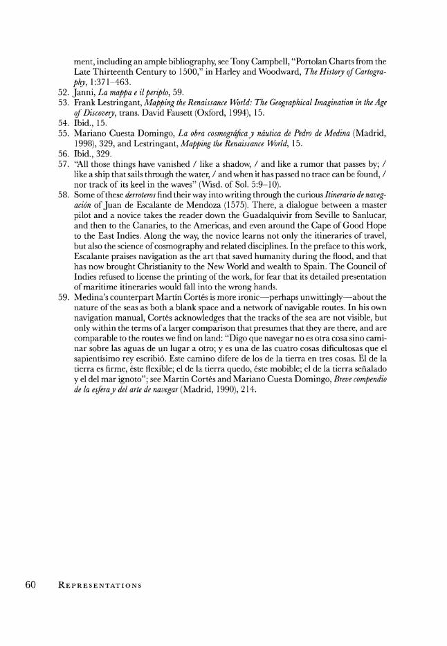
ment, including an ample bibliography, see Tony Campbell, "Portolan Charts from the Late Thirteenth Century to 1500," in Harley and Woodward, The History of Cartogra- phy, 1:371-463.
52. Janni, La mappa e ilperiplo, 59. 53. Frank Lestringant, Mapping the Renaissance World: The Geographical Imagination in the Age
of Discovery, trans. David Fausett (Oxford, 1994), 15. 54. Ibid., 15. 55. Mariano Cuesta Domingo, La obra cosmograficay ndutica de Pedro de Medina (Madrid,
1998), 329, and Lestringant, Mapping the Renaissance World, 15. 56. Ibid., 329. 57. "All those things have vanished / like a shadow, / and like a rumor that passes by; /
like a ship that sails through the water, / and when it has passed no trace can be found, / nor track of its keel in the waves" (Wisd. of Sol. 5:9-10).
58. Some of these derroteros find their way into writing through the curious Itinerario de naveg- acion of Juan de Escalante de Mendoza (1575). There, a dialogue between a master
pilot and a novice takes the reader down the Guadalquivir from Seville to Sanlucar, and then to the Canaries, to the Americas, and even around the Cape of Good Hope to the East Indies. Along the way, the novice learns not only the itineraries of travel, but also the science of cosmography and related disciplines. In the preface to this work, Escalante praises navigation as the art that saved humanity during the flood, and that has now brought Christianity to the New World and wealth to Spain. The Council of Indies refused to license the printing of the work, for fear that its detailed presentation of maritime itineraries would fall into the wrong hands.
59. Medina's counterpart Martin Cortes is more ironic--perhaps unwittingly-about the nature of the seas as both a blank space and a network of navigable routes. In his own
navigation manual, Cortes acknowledges that the tracks of the sea are not visible, but
only within the terms of a larger comparison that presumes that they are there, and are
comparable to the routes we find on land: "Digo que navegar no es otra cosa sino cami- nar sobre las aguas de un lugar a otro; y es una de las cuatro cosas dificultosas que el
sapientisimo rey escribi6. Este camino difere de los de la tierra en tres cosas. El de la tierra es firme, este flexible; el de la tierra quedo, 6ste mobible; el de la tierra sefialado y el del mar ignoto"; see Manrtin Corts and Mariano Cuesta Domingo, Breve compendio de la esferay del arte de navegar (Madrid, 1990), 214.
60 REPRESENTATIONS