Embed Size (px)
Citation preview

© 2003 - 2015 ... Naviter d.o.o.
Manual forOudie 3+
Last modified 9.12.2015
version 6.50
Oudie 3+I
© 2003 - 2015 ... Naviter d.o.o.
Table of Contents
Foreword 0
Part I Introduction 2
................................................................................................................................... 21 In the Box
................................................................................................................................... 32 Charging the battery
Part II Getting started 6
................................................................................................................................... 61 Getting to know Oudie 3+
................................................................................................................................... 62 Turning Oudie 3+ on and off
................................................................................................................................... 73 Running your Oudie 3+ for the first time
................................................................................................................................... 114 Upgrading firmware
................................................................................................................................... 145 Using vario on your Oudie 3+
................................................................................................................................... 166 Copying files to Oudie 3+
................................................................................................................................... 187 Learning to use Oudie 3+
Part III How to 21
................................................................................................................................... 211 Using Profiles
................................................................................................................................... 242 Set takeoff altitude
................................................................................................................................... 253 Manage airspace warnings
................................................................................................................................... 284 Using Thermal Assistant
................................................................................................................................... 305 Using Side view
................................................................................................................................... 316 Entering and flying the tasks
................................................................................................................................... 477 Flying with the FAI Triangle Assistant
................................................................................................................................... 508 Finish flight
................................................................................................................................... 529 Connect to the internet
................................................................................................................................... 5510 Connect to SeeYou Cloud
................................................................................................................................... 5611 Connect to Soaring Spot
Part IV Map page 59
................................................................................................................................... 601 Cursor info
.......................................................................................................................................................... 61Waypoints
.......................................................................................................................................................... 62Airspace
................................................................................................................................... 632 Glider position
................................................................................................................................... 633 Arrow towards the North
................................................................................................................................... 644 Wind vector
................................................................................................................................... 645 Glideslope indicator
................................................................................................................................... 656 Speed to Fly indicator
................................................................................................................................... 657 Vector map

IIContents
II
© 2003 - 2015 ... Naviter d.o.o.
................................................................................................................................... 658 Flight trace
................................................................................................................................... 669 Terrain collision
................................................................................................................................... 6710 Airspace warning
................................................................................................................................... 6711 Navboxes
................................................................................................................................... 6812 Animation speed
................................................................................................................................... 6913 Command bar
Part V Information page 71
Part VI Statistics page 73
Part VII Menu 75
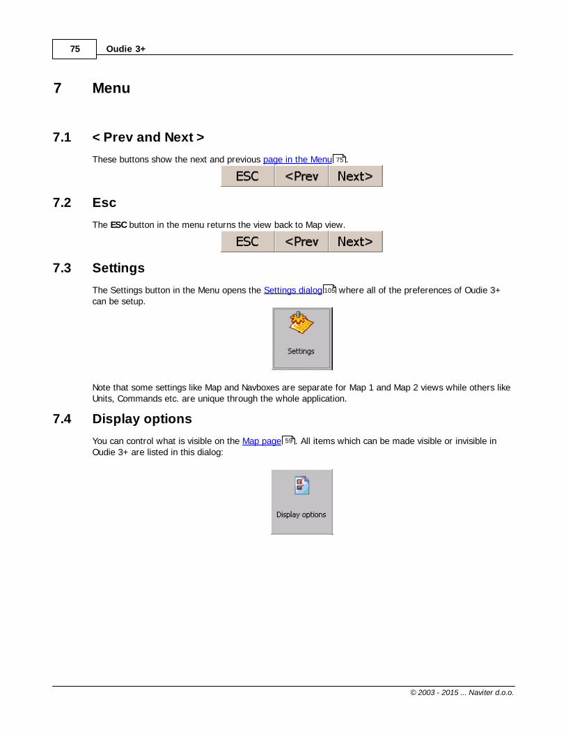
................................................................................................................................... 751 < Prev and Next >
................................................................................................................................... 752 Esc
................................................................................................................................... 753 Settings
................................................................................................................................... 754 Display options
................................................................................................................................... 765 Screen lock
................................................................................................................................... 786 Map orientation
................................................................................................................................... 797 Add Waypoint
................................................................................................................................... 828 Zoom
................................................................................................................................... 839 Wind
................................................................................................................................... 8410 Volume & Altitude
................................................................................................................................... 8511 Goto
.......................................................................................................................................................... 87Details overview
.......................................................................................................................................................... 88Edit Waypoint
.......................................................................................................................................................... 89Waypoint filter
................................................................................................................................... 9212 Task
.......................................................................................................................................................... 93List edit
.......................................................................................................................................................... 94Map edit
.......................................................................................................................................................... 95Edit Point
.......................................................................................................................................................... 96Load task
.......................................................................................................................................................... 97Task options
................................................................................................................................... 9813 Next map
................................................................................................................................... 9914 Info page
................................................................................................................................... 9915 Statistics
................................................................................................................................... 9916 About
................................................................................................................................... 9917 Exit
................................................................................................................................... 10018 Save Settings
................................................................................................................................... 10119 Thermal assistant
................................................................................................................................... 10120 Switch Profile
................................................................................................................................... 10221 Logbook
.......................................................................................................................................................... 102Statistics, replay and upload flight

Oudie 3+III
© 2003 - 2015 ... Naviter d.o.o.
Part VIII Settings 105
................................................................................................................................... 1051 Map
.......................................................................................................................................................... 106Scheme properties
................................................................................................................................... 1072 Airspace
................................................................................................................................... 1083 Waypoints (Wpts)
................................................................................................................................... 1104 Track & Target
................................................................................................................................... 1115 OLC & FAI area
................................................................................................................................... 1126 Setup Task
................................................................................................................................... 1137 Navboxes
.......................................................................................................................................................... 117Edit
................................................................................................................................... 1198 Symbols
................................................................................................................................... 1209 Warnings
................................................................................................................................... 12110 Thermal
................................................................................................................................... 12311 Polar
................................................................................................................................... 12412 Units
................................................................................................................................... 12513 Fonts
................................................................................................................................... 12614 Input
................................................................................................................................... 12815 Commands
................................................................................................................................... 12816 Setup Menu
................................................................................................................................... 12917 Files
................................................................................................................................... 13118 Log
................................................................................................................................... 13119 User Interface (UI)
................................................................................................................................... 13320 Miscellaneous (Misc)
................................................................................................................................... 13421 Hardware
.......................................................................................................................................................... 135Terminal
................................................................................................................................... 13622 Vario
................................................................................................................................... 13723 Oudie Live
Part IX Oudie firmware 140
................................................................................................................................... 1401 Main screen
................................................................................................................................... 1402 Settings screen
.......................................................................................................................................................... 141Volume
.......................................................................................................................................................... 142Backlight
.......................................................................................................................................................... 143Language
.......................................................................................................................................................... 144Autorun
.......................................................................................................................................................... 145Calibration
.......................................................................................................................................................... 146USB
Part X Windows Mobile tips and tricks 149
Part XI Technical specification 151

IVContents
IV
© 2003 - 2015 ... Naviter d.o.o.
Part XII Troubleshooting 154
Part XIII Notice of non-liability 156
Part XIV Limited Warranty 158
Index 159

Part
I

Introduction 2
© 2003 - 2015 ... Naviter d.o.o.
1 Introduction
Oudie 3+ version 6.50
Company Naviter is dedicated to solving glider pilot's problems and Oudie 3+ is one of the answers in thischallenge. It´s intended use is helping para-glider, hang glider and other pilots navigate during leisure,cross country and competition flights.
Oudie 3+ is a Personal Gliding Assistant which aims at providing everything a glider pilot needs in onesimple package. For this reason Oudie 3+ have big bright sun readable screen, excellent vario and alarge battery which is powerful enough for more than twelve hours of flying. Vario and Navigationsoftware, maps and airspaces for Oudie 3+ are already preinstalled. You can literally take it out of thebox and launch.
Oudie 3+ works great in combination with other Naviter products such as SeeYou for the PC, SoaringSpot and others. It was designed to answer the question which was most frequently posted to us as"Why do you not build the device for paraglider and hang glider pilots?"
This Manual is intended to be used with product Oudie 3+.
Naviter is a Slovenian based software company. We focus on highly featured and easy to use softwarefor glider pilots. The needs of glider pilots worldwide are what we are interested in.
Naviter d.o.o.Planina 34000 KranjSloveniaemail: [email protected]: http://www.naviter.com/
All rights reserved by Naviter d.o.o. 2003-2015
1.1 In the Box
The Oudie 3+ is delivered with pre-installed Oudie 3+ software and world-wide vector maps(topographical data, ground elevation data, cities, rivers, lakes, roads, etc.). Airspace and Airports filesfor much of the world are also pre-installed. Your Oudie 3+ was delivered in a package with the followingitems:
1. Oudie 3+2. Protective case3. Getting started manual4. SeeYou Trial CD5. Universal Wall Charger (110-220V)6. Car Charger (12V)7. USB Cable8. Velcro tape for easy installation9. PDF Manual on the CD

Oudie 3+3
© 2003 - 2015 ... Naviter d.o.o.
10. 2 pcs Naviter stickers11. USB charger cable
1.2 Charging the battery
There are several ways to charge Oudie 3+ powerful internal battery.:
Connect the universal wall Quick charger cable to AC 110-240 V power source and insert the
connector to the Oudie 3+ .
Connect the car charger to the DC 12-24 V source and insert the connector to the mini USB slot
on the Oudie 3+.
Connect the Power and Serial data cable to DC 12V power source and insert the USB connector
to the mini USB slot
Connect the USB cable to an external Power Pack battery via USB quick charger cable.
The Charging light indicates charging status of the Oudie 3+. Green light means that the device's internal
battery is fully charged. Orange light indicates that the battery is charging and blue light indicates that
the Oudie 3+ is connected to computer.

Introduction 4
© 2003 - 2015 ... Naviter d.o.o.
Fast charge with the universal wall Quick charger take about 6 hours to fully charge the Oudie 3+. Slow
charge will take about 10 hours to fully charge the battery.
Note: Charging Oudie 3+ battery during the flight is possible ONLY with the supplied USB quick charger
cable (the one with the round fast charger connector)!

Part
II

Getting started 6
© 2003 - 2015 ... Naviter d.o.o.
2 Getting started
This topic wants to cover some of the basic things you need to know about how to use your Oudie 3+. Ifthis is the first time you are using Oudie 3+ please take a few moments to read about the basics abouthow to use Oudie 3+:
. Running SeeYou Mobile for the first time
. Copying files to Oudie 3+
. Learning to use SeeYou Mobile
. Using profiles with SeeYou Mobile
. Flying badge, record and racing tasks
. Flying Assigned Area tasks
. Using Thermal Assistant
. Flying with the FAI Triangle Assistant
. Flarm Radar
2.1 Getting to know Oudie 3+
1.Power On/Off button2.Power indicator3.Earphone jack4.microSD card slot5.Charging light6. Quick charger port7.Mini USB port8.Stylus9.Speaker10.Reset key
2.2 Turning Oudie 3+ on and off
To turn the Oudie 3+ ON press the power button for 1 second. In order to prevent turning on the device
16
18
21
28
47

Oudie 3+7
© 2003 - 2015 ... Naviter d.o.o.
by accident you have to press the confirm button in five seconds.
To turn the Oudie 3+ OFF go to Menu > Next > Exit > Yes . Once SeeYou Mobile software is turned off ,
press the power button for 1 second while the device is running then choose the desired action:
Power Off: will stop the navigation and turn off the device. You should do this before long term
storage. Battery should be at least 50% full before you store it for a long time.
Sleep: will turn off the screen, GPS, Bluetooth and power down the processor. The navigation will be
put on hold and the battery will drain very slightly. After switching back on you are ready for navigation
in just a few seconds. You should use the Sleep function when you are waiting to launch and want to
conserve the battery for example. It's ok to use Sleep over night as well. The battery drain is
negligible.
Cancel: will do nothing and return focus to navigation.
To reboot press the reset button on the back of the device.
See also:
Getting to know Oudie 3+
2.3 Running your Oudie 3+ for the first time
When you turn the Oudie 3+ on for the first time or after a reset, navigation software is startedautomatically.
Create new profile Oudie 3+ has pre-installed two templates for profiles:
XC,RACE.
Choose one of them to add new profile to Oudie 3+. One application for several profiles is when you flydifferent paragliders and need different setups for them (Competition flying - RACE template, XC flying -XC template, etc...). When there is more than one profile available, you get to choose it when startingthe application for the next time.
6

Getting started 8
© 2003 - 2015 ... Naviter d.o.o.
LanguageSelect language which you would like to use on Oudie 3+ and confirm this by tapping on the Selectbutton:
RegionSelect region in which you are going to fly andconfirm this with Select button:

Oudie 3+9
© 2003 - 2015 ... Naviter d.o.o.
Connecting to the GPSWhen the navigation device is turned on for the first time or after a long period of non-use, initializing theintegrated GPS receiver can take up to 40 minutes. Optimal conditions for problem-free and fast GPSreceptions are: having a clear view of the open sky, no high buildings immediately close by andremaining in one place until the GPS position has been determined. The Navbox on the upper side ofthe map will show you the GPS status (by default - you can change the navboxes later).
Map with symbolsThis is where you will be looking for information all the time. You can do many things on the Map page:
113
59

Getting started 10
© 2003 - 2015 ... Naviter d.o.o.
You can move the map by dragging it. It will return to the position of the glider after 10 secondsautomatically or by pressing the Map orientation symbol.You can move the Navboxes around the map to place then where you need them.
You can also tap on any symbol to bring up additional dialogs for:. Map orientation by tapping on upper(North) arrow,. Wind by tapping on the Wind vector,. Map zoom by tapping on the Zoom button,. Pan mode is a special mode where you can freely move around the map to explore some detailsalong the course.. Move the glider (lower arrow ) if you tap on the glider. . Moving on Map 2 by tapping on the Map 2 Navbox .
Tapping on a waypoint on the map gives you a list of Airspaces and Waypoints . Waypoints aresorted on distance from the tap. This is a quick way to select a waypoint from a group of waypoints.
The Navboxes are what you will use to display the information you need. Be at waiting for Start gate,Final glide, Navigation, Optimization or another issue, use Menu > Navboxes to select which items youwant displayed.
Command barholds 2 shortcuts to specific actions. In addition to the Command bar, actions are also assigned to any
113
78
83
82
78
63
113
107 108
113
69

Oudie 3+11
© 2003 - 2015 ... Naviter d.o.o.
hardware buttons on the Pocket PC. You can select which buttons do which actions through Menu >Settings > Commands .
The default actions for software buttons from left to right (Command bar) are:. Zoom. Menu
Try the functions of these buttons.
See also:Getting Started
2.4 Upgrading firmware
Keep your Oudie 3+ updated at all times with OudieUpdater.
OudieUpdater is a very simple, amazingly effective software. It will help you keep your Oudie 3+ updatedwith latest versions, airspaces files and maps at all times.
On windows it installs into the tray, sits there quietly until there is something you need to know. That’sall! Press the buttons when there is something to update and keep your Oudie 3+ updated at all times.Just look out for this message:
Click on message and OudieUpdater will show up:
128
82
75
6

Getting started 12
© 2003 - 2015 ... Naviter d.o.o.
How it works?
Please download and install OudieUpdater on your PC: http://download.naviter.com/OudieUpdater/ousetup.exe
1. To update Software, Airspace or Maps press buttons by side and wait until copying of all files iscompleted.
2. Disconnect Oudie 3+ from PC.
3. Reboot Oudie 3+ with restart button on the back side.
4. Wait until it boots into an Update dialog box.

Oudie 3+13
© 2003 - 2015 ... Naviter d.o.o.
5. Press "Update" and wait until the process is finished.

Getting started 14
© 2003 - 2015 ... Naviter d.o.o.
6. Reboot Oudie 3+. That´s all. Now you are running latest software version.
If you need to check your Oudie 3+ software version go to: Menu > About.
2.5 Using vario on your Oudie 3+
Oudie 3+ features an excellent vario. It is the best vario you can find on the market. It is extremelyaccurate and responsive at the same time.
You can control the audio settings of the vario on the Menu > Settings > Vario page. We went into alot of trouble fine tuning the vario sound. Make sure to try the default settings in the air before youchange them.
You can control the size and position of the Vario Symbol on the map. Simply drag it on the screen if youwish to move it to a new position. Go to Menu > Settings > Symbols > Vario to change it size andappearance. You can choose from two different shapes for the vario, its transparency, size and more.Once you finished with selected settings you can also ?lock? vario position: Menu > Settings > Symbols> Vario > Do not allow drag (remove checkmark) > OK.
If you want to remember this setting, please save the profile with Menu > Next > Save Settings > SaveProfile > Yes.
136
119

Oudie 3+15
© 2003 - 2015 ... Naviter d.o.o.

Getting started 16
© 2003 - 2015 ... Naviter d.o.o.
Red symbol is average vario for last circle in thermal. Blue symbol is last (current) thermal vario.Practically is very useful to see when you climbing if thermal is increasing (red diamond is above blue T)or decreasing (red diamond is below blue T).
See also:Menu > Settings > Vario
2.6 Copying files to Oudie 3+
Copying files on the Oudie 3+ similar to Upgrading the firmware . Just copy files in the root of yourOudie 3+ Resident Flash memory when connected to PC with the supplied USB cable.
If you need more instructions this is the whole procedure:
1. Connect your Oudie 3+ with PC using the USB cable which was supplied in the box,2. Once connected, tap "Connect to PC" or the USB Stick icon on Oudie 3+,3. You should now see Oudie 3+ as an external Mass Storage drive on your PC (named TFAT),4. Copy Files to the root or folder on your Oudie 3+ device,5. Once you finished copying files Safely remove your Oudie 3+ from the PC software.6. Disconnect Oudie 3+ from PC and run the Oudie 3+ software.
136
11

Oudie 3+17
© 2003 - 2015 ... Naviter d.o.o.
7. Then go to Menu > Settings > Files > Waypoints > "..." > Select your waypoints file > press Activeand close all dialogs with OK.
8. We strongly recommend that you remember this setting with Menu > Next > Save Settings > SaveProfile > Yes.
Mobile Wizard connects SeeYou with Oudie 3+ to transfer files via Active Sync. Mobile Wizard neverexpires. That means you don't have to have a registered version of SeeYou to transfer all of the requireddata to the Pocket PC.
First page of the Mobile wizard allows you to select the Items you wish to transfer to the device. Youcan choose from . Waypoints and Tasks. Airspace. Settings (Vector map color scheme, units, triangle properties, default observation zones)
Second page gives you the possibility to select basename and destination folder for the data you haveselected to upload on the first page.. Files that will be created will have the same name as Basename and respective extensions CUB forairspace, CIT for vector maps and CUP for waypoints and tasks.. Use the Browse buttons to select the destination folder easily.
Third page asks you to draw a rectangle for the area you want to transfer to the Pocket PC.Use Ctrl+Up, Ctrl+Down to zoom out and zoom in. Click on the the borders of the map to movehorizontally and vertically. This is the same procedure as in the other Map views in SeeYou.
Fourth page shows progress in transferring or saving files.
Once the transfer has completed successfully, you may close Mobile wizard with the Finish button.

Getting started 18
© 2003 - 2015 ... Naviter d.o.o.
See also:Getting Started
2.7 Learning to use Oudie 3+
There is two recommended options to learn SeeYou Mobile before you get airborne.
File replayThis is by far the most efficient way to learn Oudie 3+ software. What it does is it replays an alreadyflown flight and enables you to see the data you would have been looking at if you had Oudie 3+ with youon the particular flight.
In order to set this up, copy some of your flights from the desktop PC to your device. Then go to Menu >Settings > Input , then change input to "File". Press the "..." button and choose a flight you wish toreplay. Alternatively you can go to Menu > Logbook > choose the flight you wish to replay > Tools >Replay flight. Then use the buttons to change Waypoints, MacCready and pages. Tap on the screen tosee what happens and setup Navboxes to what you want them to be. Note that you can setup Navboxes
separately for each of the two Map pages.
SimulatorIn the Simulator input mode, you can move the glider freely even without a prerecorded flight whichenables you to go places you haven't visited in the air yet. To move the glider, tap on it, then drag a lineout of the glider in the direction you want it to move. The longer the line, the faster it will go in the
6
126
113

Oudie 3+19
© 2003 - 2015 ... Naviter d.o.o.
specified direction.
Learning SeeYou Mobile on the ground will give you time to think about gliding, task and scenery in theair rather than software.
Oudie 3+ Simulator for desktop PCIn addition we have created a 100% functional copy of our software which runs on the desktop PC. Thisprogram enables you to test all features of Oudie 3+ before you decide that you would like to use it inflight. To download the simulator for PC please visit our website: http://www.oudie3.com/products/oudie-3/
See also:Getting Started 6

Part
III

Oudie 3+21
© 2003 - 2015 ... Naviter d.o.o.
3 How to
The How to Chapter will cover the basics and some details about how to use your Oudie most effectively.
Using ProfilesSetting the takeoff altitudeManaging airspace warningsUsing the Thermal AssistantUsing Side viewEntering the taskFlying badge, record and racing tasksFlying the Assigned Area tasksFlying with the FAI Triangle AssistantUsing the Flarm RadarUse Vario in Oudie IGCFinish flightConnect to the internetConnect to SeeYou CloudConnect to Soaring Spot
3.1 Using Profiles
If you feel no need to use more than one set of Navboxes or fly more than one type of gliders ignorethis feature and go read the next chapter.
21
24
25
28
30
47
50
52
55
56
113
How to 22
© 2003 - 2015 ... Naviter d.o.o.
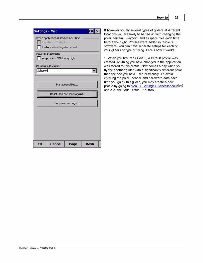
If however you fly several types of gliders at differentlocations you are likely to be fed up with changing thepolar, terrain, waypoint and airspace files each timebefore the flight. Profiles were added in Oudie 3software. You can have separate setups for each ofyour gliders or type of flying. Here's how it works.
1. When you first ran Oudie 3, a Default profile wascreated. Anything you have changed in the applicationwas stored to this profile. Now comes a day when youfly the another glider with a significantly different polarthan the one you have used previously. To avoidentering the polar, header and hardware data eachtime you go fly this glider, you may create a newprofile by going to Menu > Settings > Miscellaneousand click the "Add Profile..." button.
133

Oudie 3+23
© 2003 - 2015 ... Naviter d.o.o.
2. You get to choose to either. Copy current profile (which makes an exact copy ofyour current settings),. Create a new profile (which creates a copy of thedefault settings).
You may give the new profile a name according to whatyou are going to use it for. Be it "RACE", "XC" or "Hikeand fly glider".

How to 24
© 2003 - 2015 ... Naviter d.o.o.
3. Next time you start Oudie 3 you will have two (ormore) profiles to choose from. You have 10 seconds toselect a profile. If you do nothing, the profile you usedlast is loaded.
4. After you have loaded the profile for the first timeyou will want to set it up according to your preferences.Here is a handful of settings you will probably want tochange before use:Links to Terrain, Airspace and Waypoint filesPilot name and Glider type settingsNavboxes for Map1Navboxes for Map2
See also:Getting Started
3.2 Set takeoff altitude
Setting the takeoff altitude correctly could be the difference between a successful and a frustrating endof the flight.
The altitude in the Oudie 3+ is recorded at the standard pressure of 1013.25 hPa. In order to know youcurrent altitude above mean sea level and your current flight level altitude the altitudes need to becorrected to correspond with the real world.
There are several ways how the Oudie 3+ can correct the takeoff altitude. It will typically assume thatthe pressure recorded by the pressure sensor is relative to the standard atmosphere pressure of 1013.25hPa (but it is even possible to correct for that, see below). It is quite possible to correct the altitudes toQNH automatically with the data which is already available on the Oudie 3+. If you get the informationfrom an external source (such as the ATC tower or the competition task sheet) then it is possible to enterthe values manually as well.
In order to correct the takeoff altitude you need to go to Menu > Vol & Alt. dialog.
129
131
113
113
6

Oudie 3+25
© 2003 - 2015 ... Naviter d.o.o.
By default the Auto QNH checkbox is checked. Auto QNH will try to correct the takeoff altitude to yourcurrent altitude by searching for a nearby airport or by using the Ground elevation at your location or (ifall else fails) using a very much averaged GPS altitude (but the latter is only a fallback and should notnormally happen since there is a worldwide terrain database already installed on each Oudie). Auto QNHsetting will give you a very good idea about the current pressure level and it works automatically withoutyour input.
If you want to change the altitude manually you should disable the Auto QNH navbox and enter thetakeoff altitude manually. If the Linked checkbox is checked (which it is by default) then the pressurelevel will increase accordingly.
Typically in a competition you could get a complete set of data from the competition organization. In thiscase remove the Auto QNH checkbox AND the Linked checkbox. Enter the takeoff altitude AND the QNHpressure given from the competition then press ok. This way you will see exactly the same altitudesduring your flight as the ones that you will be scored by later in the evening. DO NOT set the "linked"checkbox back in this case because it will change the pressure level back to the "linked" value.
3.3 Manage airspace warnings
Avoiding forbidden airspace is often just as important as navigating in general. It can however be muchtrickier than finding the right valley to go down to since the airspace structure is very abstract and often

How to 26
© 2003 - 2015 ... Naviter d.o.o.
complicated. SeeYou Mobile will be your best friend if you use the whole potential of what it's got tooffer.
1. Airspace Warning
The first stage - let's name it the Airspace Warning- is often merely informative. The screen will displayan orange banner at the top of the page andhighlight the airspaces you are about to encounter.It will also display a line with distances from yourposition to the narest position of each airspace youare about to encounter. And it will beep briefly.
You get to choose to turn the airspace warning offfor the airspace which is listed in the banner. Youcan turn it off for either. Today - until next takeoff. 5 minutes - note that this number is userselectable through Menu > Settings > Warnings). Ignore - for as long as you are flying towards it itwon't beep again)

Oudie 3+27
© 2003 - 2015 ... Naviter d.o.o.
2. Airspace Alarm
Once you come too close for comfort an airspacealarm will sound. It gives you a red banner at thetop where you can read all about the airspace inquestion and it will highlight the airspace inquestion. It will also draw the line to the closestpoint of the airspace and it will give you a soundalarm continuously.
You still get to choose to turn this alarm off for. Today - until next takeoff. 5 minutes - user selectable in Menu > Settings >Warnings. Mute - continue to display everything but stop thesound alarm
After you have pressed Mute you can still Ignore thisairspace alarm.
3. Helpful Navboxes
There are three airspace related navboxes which will give you a good overview of the airspace situationif you are familiar with what they are displaying:
1. "Nearest airspace - Horizontally" gives you the distance from your position to the nearest position of anairspace where you are not horizontally inside (i.e. you are not below this airspace yet)
2. "Horizontally nearest airsapce - Altitude" gives you the altitude difference towards the horizontallynearest airspace. The altitude difference is negative if you are below horizontally nearest airsapce. It ispositive if you are above and "Inside" if you are about to hit the lateral borders of the airspace inquestion.
3. "Nearest airspace - Vertically" gives you the altitude difference towards the airspace above or belowthe glider. The value is negative if you are below the airspace. It is positive if you are above, "Inside" ifyou are already inside an airspace and "N/A" if there is no airspace at your location.
In addition to the airspaces there is also a very useful Action which can be assigned to any Navbox. It isthe action "Highlight nearest airspace" and it is assigned to the "Nearest airspace - Horizontally" bydefault. If you touch a Navbox which has this action assigned to it, SeeYou Mobile will highlight theairspace in question. It will link the glider with the airspace and display the distance from the glider to theairspace.

How to 28
© 2003 - 2015 ... Naviter d.o.o.
4. Screen taps
In addition to all the above you may tap anywhere on the screen and then choose "Airspace" to quicklyaccess the list of airspaces at the location of the tap. With this list you can quickly change the visibility ofthe airspaces or simply get an overview of what lies ahead. You can also change the properties of anairspace such as lower or upper limit.
With this information airspace navigation should be easy and understandable even in a rather complexairspace environment.
Read also:. Setting up the Warnings. Changing properties of an airspace. Loading (multiple) airspace files
3.4 Using Thermal Assistant
Thermal assistant is a feature of Oudie 3+ which should help you get centered in a lift more quickly if youdecide to follow its instructions.
Thermal assistant analyses the lift in your thermal. It calculates the average and follows how strongly thevario values change in each circle.
It uses three ways to catch your attention:1. You may choose between Bubbles or a Zoomed map which shows the best part of the lift. Bubblesare disabled by default, zooming in is enabled.
2. Thermal Assistant audio warning goes off if variance is large enough (see Settings - Thermal ).It whistles a selected amount of seconds or degrees (see Settings - Thermal ) before the glider willreach the same part of the circle where maximum lift was reached in the previous circle.
120
107
62
121
121

Oudie 3+29
© 2003 - 2015 ... Naviter d.o.o.
3. Thermal assistant graphics is displayed if variance for displaying the thermal assistant is largeenough (see Settings - Thermal ). The size of the bubbles represents the amount of lift. The color ofthe bubble is relative to the MacCready setting. Red is better thank MC, blue is more than 0.5m/s (1kts)less than MC, yellow is in between. The arrow is pointing towards the maximum of the lift in the previouscircle while the length of the arrow is how "strong" the advice is to move your circle elsewhere. Thearrow is longer if variance is larger.
121

How to 30
© 2003 - 2015 ... Naviter d.o.o.
Your job:. find a thermal. start circling. look outside. observe the thermal clues. observe traffic in your vicinity. make use of Assistant's suggestions
Assistant's job:. analyze the thermal. find the strongest lift in the circle. make audio and visual suggestions
We were not trying to develop a ThermalWizard, just an Assistant for the timeswhen you are tired or have better thingsto do than focus 100% on the thermal. Itwill only sound a bell if the thermal variessignificantly in strength.
If you would like to display Thermal assistant regardless of the current vario variation, feel free tonavigate to the Menu and press the Thermal Assistant button. To close the Thermal Assistant, just tapthe screen anywhere.
We will be happy if you continue to enjoy soaring and if you never find the need to use the ThermalAssistant at all :-)
See also:Getting StartedSettings - Thermal
3.5 Using Side view
Side view operates it two different ways. In free flight (no active task or "go to" navigation) it will slicethe terrain and airspaces in your current heading. If you are flying a task or navigating to a certainwaypoint than the Side view will slice the terrain and airspaces from your position towards the activewaypoint.
6
121

Oudie 3+31
© 2003 - 2015 ... Naviter d.o.o.
. White dot represents your altitude.
. Grey line represents your current L/D ratio (color is the same as of Current track vector. See more at Track & Target ). Pink line represents your required L/D ratio (color is the same as of Target. See more at Track &Target )
Side view can be accessible by going to Menu>Display options>Side view . Turning Side view on andoff is also possible with navbox "Side view" or setting an action on any of your current navboxes(excluding ones with action function such as "zoom+"). Once Side view is visible on your map you caneasily turn it off with touching the display in the area of the Side view, similar as turning off the Thermalassist.
See also:Track & TargetDisplay options
3.6 Entering and flying the tasks
Entering the tasks by list
110
110
75
110
75

How to 32
© 2003 - 2015 ... Naviter d.o.o.
This is a tutorial about entering the task in Oudie 3. We have had the privilege to look over the shouldermany impressively experienced pilots who have found a very difficult way to enter a task into Oudie3.
Please read this because entering the task is just that - enter the waypoint names, set the times (Gate,Start speed section, End speed section, Task deadline) and Sector type (Line, Cylinder, FAI sector orAssigned area). No setting up of observation zones is neccessary. Tutorial will focus on entering thedemo task. The default one in the evaluation version of Oudie 3. The task will become a 39,9 km Race togoal in the west part Slovenia - flying site Lijak. Both Racing, Record tasks as well as Assigned Area tasksare covered.
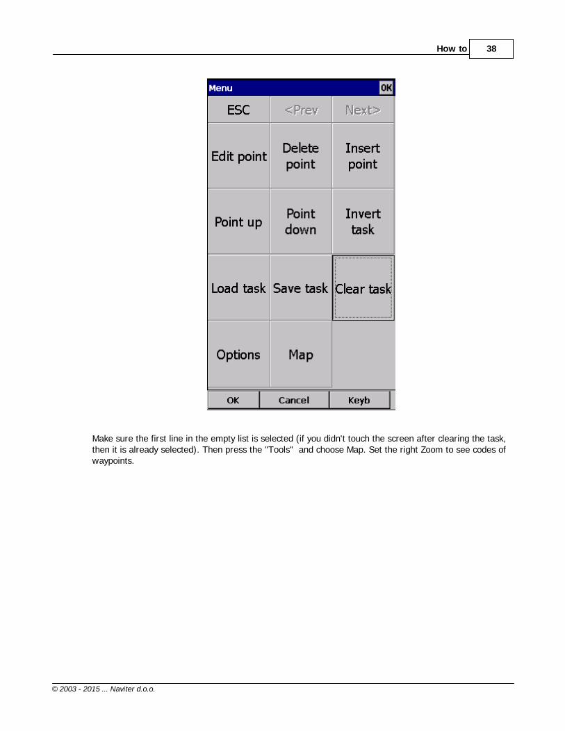
Always start from the scratch. Menu > Task > Tools > Clear task:
Make sure the first line in the empty list is selected (if you didn't touch the screen after clearing the task,then it is already selected). Then press the "Insert" or ?Keyb? (as in Keyboard) button:

Oudie 3+33
© 2003 - 2015 ... Naviter d.o.o.
Start typing and you will notice that the waypoint name auto-completes while you are typing (note thatthe keyboard characters which do not make sense are disabled while you type):

How to 34
© 2003 - 2015 ... Naviter d.o.o.
Note that L and 01 keys were pressed while "058" was auto-completed. If you know your waypoint is inalphabetical vicinity of the currently auto-completed name of the waypoint, you may also use the "<<"and ">>" buttons on the full screen keyboard to advance the waypoint names alphabetically. Once youhave found the waypoint you were looking for, press OK.
Edit point dialog will open automatically after choosing each waypoint. Setup these values to flycompetitions or FAI records.
95

Oudie 3+35
© 2003 - 2015 ... Naviter d.o.o.
Press the "OK" button again and start entering the Start Gate turnpoint's name, L01058 in this example:

How to 36
© 2003 - 2015 ... Naviter d.o.o.
Note that after entering "L" and "0" the suggested waypoint name is "L01058". If not "L01058" - Press">>" once and you are now at "L01058". Press OK.
After you have entered the task waypoints, check that waypoint sectors once again (cylinders, lines, FAIsectors) and times are setup correctly. Note that you can choose your default Sector type settings inMenu > Settings > Task > Observation Zone > Type > Cylinder are what you wanted to use on mostflights!
112

Oudie 3+37
© 2003 - 2015 ... Naviter d.o.o.
Entering the tasks by Map
Entering the task by Map is also useful way to set the task. It help you to make easier visualization of thetask. This tool is most useful for Task comity, to easy set and plan the task on competitions. You can alsoquickly create a task without waypoints for your upcoming cross country flight.
As before: Always start from the scratch. Menu > Task > Tools > Clear task:
How to 38
© 2003 - 2015 ... Naviter d.o.o.
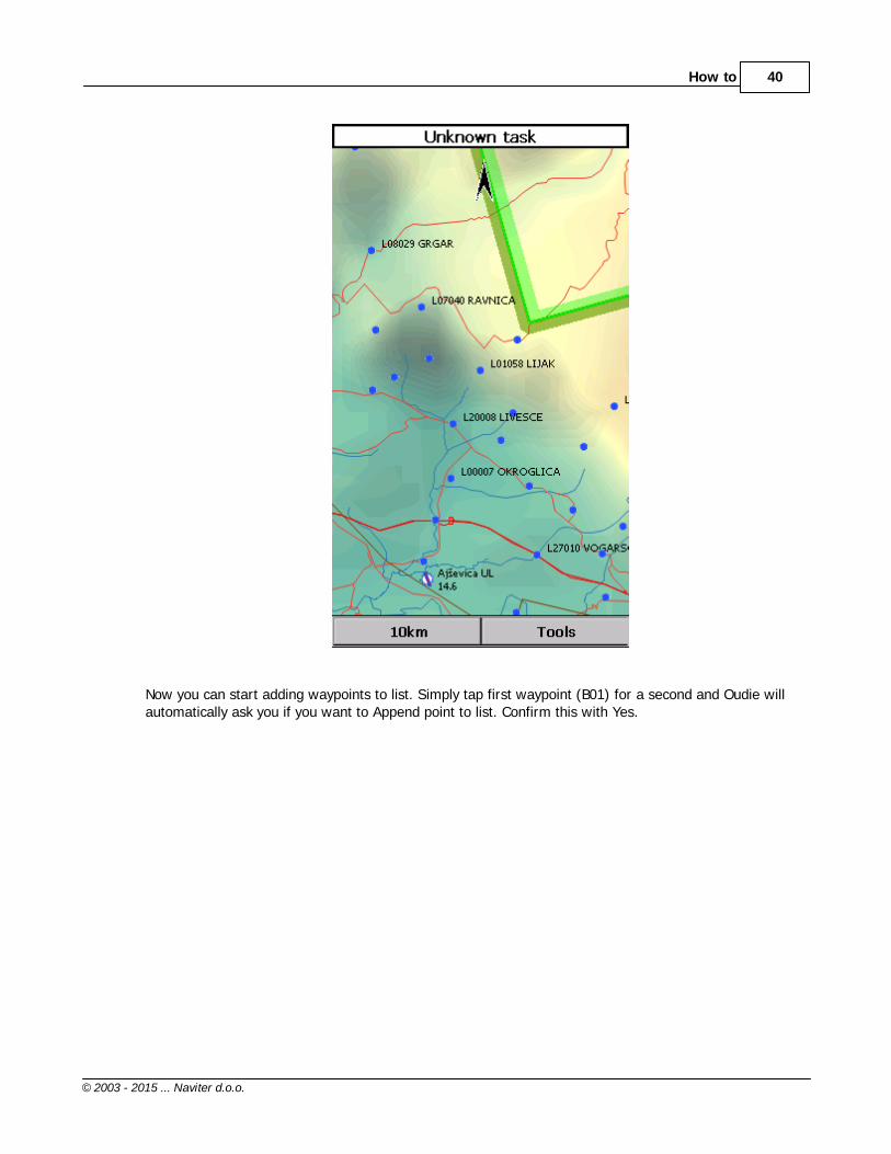
Make sure the first line in the empty list is selected (if you didn't touch the screen after clearing the task,then it is already selected). Then press the "Tools" and choose Map. Set the right Zoom to see codes ofwaypoints.

Oudie 3+39
© 2003 - 2015 ... Naviter d.o.o.
How to 40
© 2003 - 2015 ... Naviter d.o.o.
Now you can start adding waypoints to list. Simply tap first waypoint (B01) for a second and Oudie willautomatically ask you if you want to Append point to list. Confirm this with Yes.

Oudie 3+41
© 2003 - 2015 ... Naviter d.o.o.
With tap on OK button continue with adding waypoints trough all the task. Use Pan mode to findwaypoints on Map for which you´re looking for.

How to 42
© 2003 - 2015 ... Naviter d.o.o.
After you have added all the task waypoints press Tools > List. Check waypoint sectors (cylinders, lines,FAI sectors) and times once again they are setup correctly. Once you finished tap OK and your task isready to fly.
Start and re-start the task
To make a re-start. Change the target waypoint back to start point. The quickest way to do it is to openthe Task dialog, select start point and press Goto. Statistics will be reset, when you cross the start lineagain.
Oudie 3+43
© 2003 - 2015 ... Naviter d.o.o.
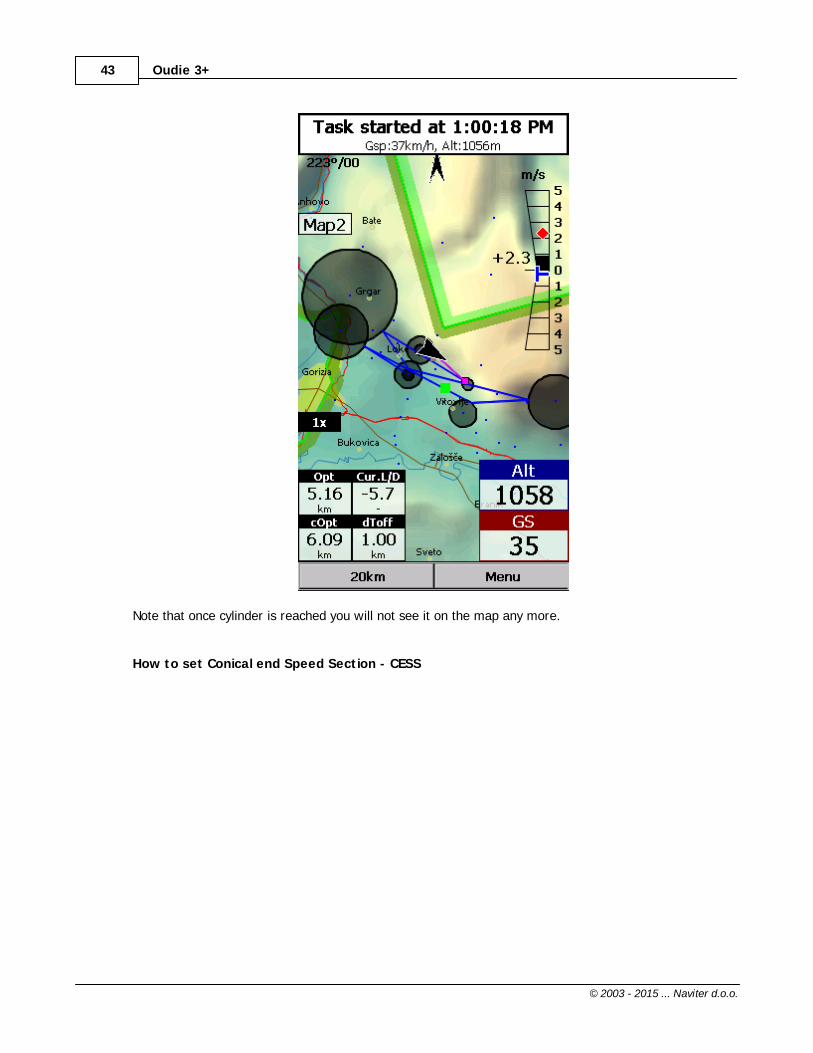
Note that once cylinder is reached you will not see it on the map any more.
How to set Conical end Speed Section - CESS

How to 44
© 2003 - 2015 ... Naviter d.o.o.
1. Set task as described above.2. Choose End Speed Section Point.3. Set Cone: ?None? - there is no cone, ?1:2.5? or ?1:4?... When cone is set as End speed section thisobservation zone is as marked with crossed lines on map page (visible also in wayponit Edit dialog -picture above).4. OK.
Flying Conical End Speed Section - CESS

Oudie 3+45
© 2003 - 2015 ... Naviter d.o.o.
Side viewSide view is showing terrain collision from your position to the target including Airspaces, observationzone(s), Current L/D (grey line) and Required L/D or arrival altitude (purple line). You can turn it ON/OFFwith Action on any Navbox. You´ll find Action name as "Toggle side view" in Menu > Settings > Next >Navboxes > Select one Navbox > Action > Toggle side view .67

How to 46
© 2003 - 2015 ... Naviter d.o.o.
Flying the taskTo navigate during the task use all of the features that are made available to you through Oudie 3software:. Map pages to see where you are,. Navboxes to see the flight parameters you are interested in,. Statistics to see what you have done,. Airspace warning to keep yourself out of trouble,. Goto dialog to find nearest airports etc.,. Side view to see where to set it.
Final glideHere's a suggestion. Flying final glides is the most comfortable when you use the Required L/D andCurrent L/D navboxes . What they do is they show the required L/D to the finish line and current L/Dyou are doing at the moment. You are on glide slope when Current L/D is higher than Required L/D. Thecalculation already includes reserve altitude. The nice part is that it is insensible of the MC setting, gliderpolar, wind calculation etc. All of them can be wrong when you try to math through the glider polar.
Current L/D however is pragmatic - it tells you what you are doing. Required L/D is pragmatic as well. Ittells you what you should be doing. If Current L/D is higher than the Required one you are doing good. Ifit looks like you can keep going like that, you are doing great.
59
113
73
67
85
67
113
Oudie 3+47
© 2003 - 2015 ... Naviter d.o.o.
Have fun making those final glides!
Go fly the task and enjoy!
SAVING TASK FOR LATER USE
It is always wise to make sure you have all the data securely stored in case of an unintended outage ofthe device. Start from the main screen and select Menu > Next > Save Settings > tick the "Save profile"and "Save waypoints and tasks" checkboxes (if they are both enabled), then tap "Yes".
See also:Getting Started
3.7 Flying with the FAI Triangle Assistant
FAI Triangle Assistant helps you complete the largest possible FAI Triangle.
You don't have to do much to use the FAI Triangle Assistant. Just turn it on and fly is how we tried todesign the assistant. Here's how it works.
Turning the FAI Assistant on or off follows the same phylosophy as toggling the Map, Waypoints,Airspace, Navboxes etc. It is controlled through the Display Options dialog.
6
75

How to 48
© 2003 - 2015 ... Naviter d.o.o.
Flying the Free FAI Triangle taskOnce the FAI Area is on, you don't have to do much. You are of course required to know at least roughlywhich direction you would like to fly to fly a triangle. The larger the triangle you are attempting, the moreyou will know where to go. FAI Triangle Assistant will simply follow what you are doing. As you fly thefirst leg it won't yet know which way you are going to fly. That is not a problem. The FAI Area will bedrawn on one side of the first leg. If you would like it to be on the other side, simply tap inside the areaand it will rotate (provided that "Rotate on click" is enabled in the settings, which - by default - it is).
Once you have turned your first waypoint, simply continue to fly towards your other waypoint (or rather alarger area where you would like to turn your second waypoint). As soon as the triangle you have flownis deep enough the FAI Area changes. It is not drawn on the longest leg anymore. Instead it is drawn onthe last leg you have flown. That means it is showing you the way towards the area where you will beable to turn your second waypoint and allow your whole flight to be an FAI triangle.
When you are near your second waypoint you will appreciate some help from the FAI Triangleoptimization navbox, which is available through the list of Navboxes . Place it visibly on the screen toknow exactly how large the triangle will be if you can finish it home. After you are happy with what youhave done in your second area, head home. The FAI Triangle optimization should not change anymore,it's just about getting home.
113
Oudie 3+49
© 2003 - 2015 ... Naviter d.o.o.
The above example focused on an FAI Triangle which has been started from one of its corners. Flying atriangle with the start on the leg is no different. The only difference is that the second point you turnrepresents the first point from the above example and the third one is the final one from which you flyhome.
Finishing the taskAn FAI Triangle is not finished unless you fly back to your start point. One finish fix within 1 km radiusfrom another fix that occured before turning the 1st waypoint of the optimized triangle is required tofinish the task. It may be a single fix if you started your triangle in one of its corners. It is a whole seriesof fixes between soaring begin and the first waypoint if you started the triangle on one of its legs.
FAI Triangle Assistant also helps you identify the exact course to fly by always highlighting a 1kmdiameter circle around the closest available finish fix.
Rotating the areaSometimes the flight requires much more thinking than the above examples. You may wish to know ifyour current leg is long enough already to cover Town X with the FAI Area of your current flight. For thisreason you will want to rotate the FAI area from its current position. It can hardly be easier to do -simply tap on the FAI Area on the moving map and it will rotate. If you are on your first leg (or not farenough on the second), it will rotate left/right around the first leg. Once you are far enough on thesecond leg to make it obvious which way you are going to fly the triangle, it will rotate around the legs.All this provided that "Rotate on click" is enabled in the settings, which - by default - it is.
The FAI Area icons may also be placed on the Command bar if you wish to have quick and constantaccess to them in flight. There are options for toggling the FAI Area and Rotating the FAI Area under Menu > Settings > Commands .
FAI Triangle Assistant preferencesIf you would like to influence the look and feel of the FAI Triangle Assistant you may do so through Menu> Settings > OLC & FAI Area dialog.
Example shows kilometer lines for Triangles between 140 - 260 km. If you fly into the violet area, thetriangle will be an FAI triangle.
128
111

How to 50
© 2003 - 2015 ... Naviter d.o.o.
See also:Getting Started
3.8 Finish flight
Oudie 3+ will finish the flight automatically without needing any input from the user. Once the flight isfinished and signed it will copy the flight to the micro SD card if such card is present in the Oudie 3+.
If you want to speed up this process you can however press the "Finish now" button on the screen assoon the message ?Flight will finish? is displayed.
6

Oudie 3+51
© 2003 - 2015 ... Naviter d.o.o.
Once the flight is finihsed a statistics report from the flight is displayed:

How to 52
© 2003 - 2015 ... Naviter d.o.o.
Press OK to navigate back to the Map page.
3.9 Connect to the internet
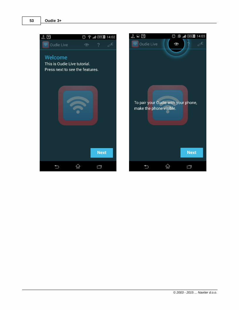
It is possible to connect any Oudie running SeeYou Moblie software to the internet. This is achieved byusing an Android smart-phone as an internet proxy. The Oudie connects to the phone through Bluetoothwhile the phone then connects to the internet by the any means available to the phone - typically Wifi orData plan.
In order to connect your Oudie to the Android smartphone you need to install a free app "Oudie Live"from the Google Play store.
Once you have installed the Oudie Live app please follow the instructions on the smartphone to pair thetwo devices. If you wish to replay the tutorial on the phone press the "?" button at the top of the screen.
Here it is:
Oudie 3+53
© 2003 - 2015 ... Naviter d.o.o.

How to 54
© 2003 - 2015 ... Naviter d.o.o.

Oudie 3+55
© 2003 - 2015 ... Naviter d.o.o.
As simple as that.
3.10 Connect to SeeYou Cloud
SeeYou Cloud links all of the Naviter software into one seamless package. Oudie 3+ enables you toupload your flights to the SeeYou Cloud and afterwards analyze it in SeeYou, SeeYou for Android or sendit to your email (via SeeYou for Android).
If you have not yet connected your Oudie 3+ to Oudie Live app on your Android device please follow thesteps in the instructions for Connect to the internet .
Once you’re connected turn on your Oudie 3+ and go to Menu > Settings > last page > Oudie Live> SeeYou Cloud. Verify your SeeYou Cloud account and you are ready to go!
To upload your old flight from your device go to Menu > Logbook and choose the flight you wish toupload. Afterwards press Tools > Upload to SeeYou Cloud. Simple as that!
52

How to 56
© 2003 - 2015 ... Naviter d.o.o.
See also:
Connect to the internetConnect to Soaring Spot
3.11 Connect to Soaring Spot
You can upload your flight to the competition office totally hands free. And in addition to that you candeclare the task to your Oudie 3+ from Soaring Spot automatically.
1. Connect Oudie to Soaring SpotIf you have not yet connected your Oudie 3+ to Oudie Live app on your Android device please follow thesteps in the instructions for Connect to the internet .
Once you’re connected turn on your Oudie 3+ and go to Menu > Settings > last page > Oudie Live> Soaring Spot. Choose your competition and the class you are competing in from the list. That’s it!
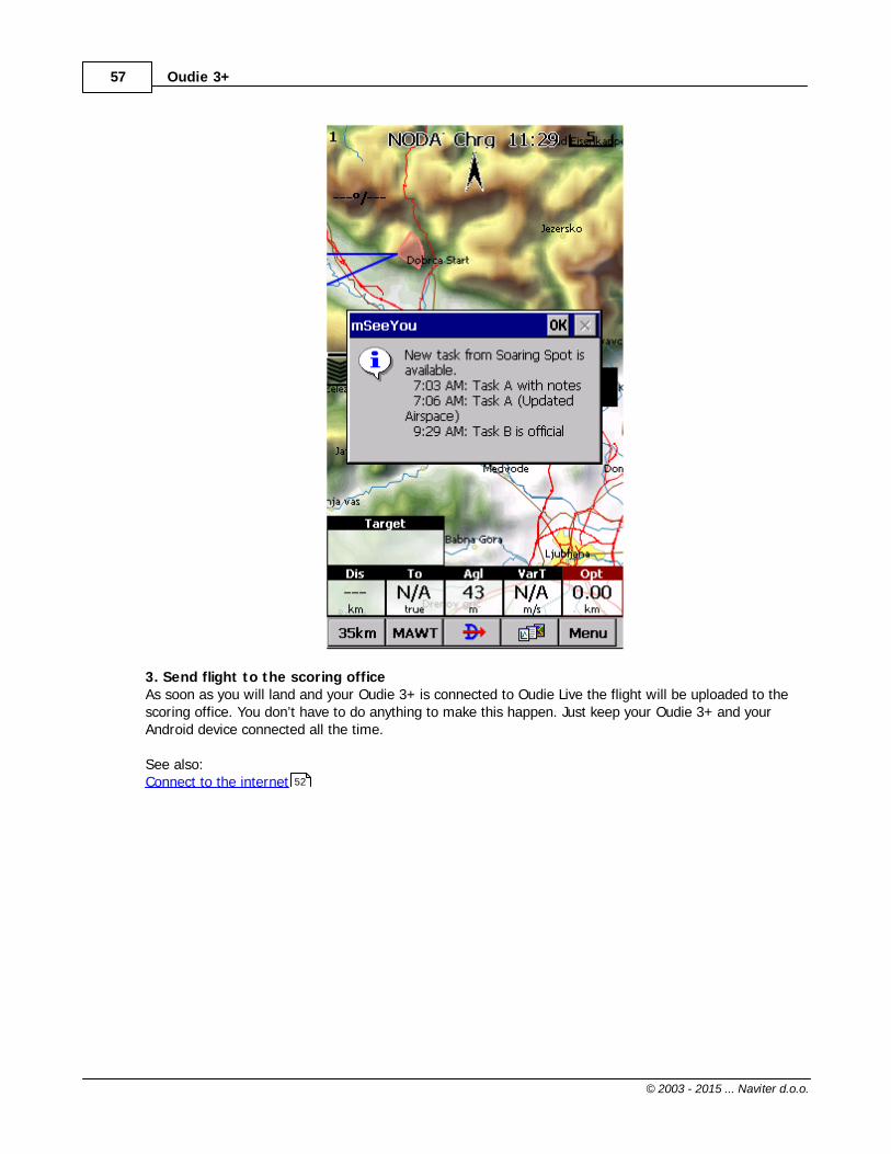
2. Download task from Soaring SpotIf you enabled the checkbox “Auto update task” then you don’t have to do anything. As soon as thecompetition organization publishes the task for “Today” and your Oudie 3+ is connected to Oudie Live youwill receive the latest task on your Oudie 3+.
52
56
52
Oudie 3+57
© 2003 - 2015 ... Naviter d.o.o.
3. Send flight to the scoring officeAs soon as you will land and your Oudie 3+ is connected to Oudie Live the flight will be uploaded to thescoring office. You don’t have to do anything to make this happen. Just keep your Oudie 3+ and yourAndroid device connected all the time.
See also:Connect to the internet 52

Part
IV

Oudie 3+59
© 2003 - 2015 ... Naviter d.o.o.
4 Map page
Map view is the main Oudie 3+ window. It contains the following elements:. Glider position. Arrow towards the North. Wind vector. Vector map. Flight trace. Terrain collision. Airspace warning. Navboxes. Animation speed. Command bar
A function is assigned to each one of these elements. It is described in the chapters you will access byfollowing the above links.
An important feature of the Map page is Cursor info .
There are two Map views (Map 1 and Map 2) which are setup independently from each other. Each mapview can be orientated differently, have different Zoom levels, details of the map and its own Navboxes.This is useful because you can switch from an overview map.
Overview of the most important features of the Map view:
63
63
64
65
65
66
67
113
68
69
60

Map page 60
© 2003 - 2015 ... Naviter d.o.o.
4.1 Cursor info
A tap on the map brings up a dialog with relevant information about. Waypoints. Flarm. Airspace. Task
If either of the items above is present within the Drag limit distance from the tap, such information ispresented in a dialog.
61
62
133

Oudie 3+61
© 2003 - 2015 ... Naviter d.o.o.
4.1.1 Waypoints
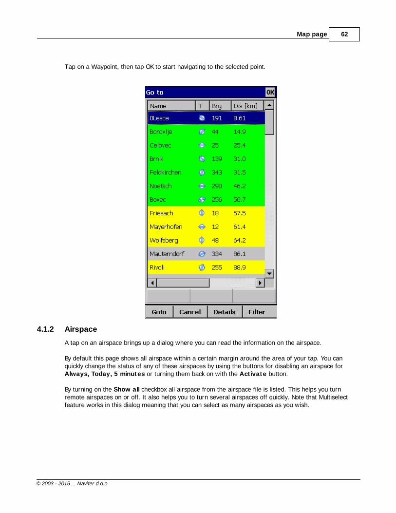
If a tap on the map occurred close to a Waypoint, cursor info dialog appears with Waypoints sorted ondistance from the position where the tap occurred.
You can also get a list of Waypoints, sorted on direction. Tap the screen and hold it down, then move thefinger in one direction. You will get a list of points sorted on distance (+-15 degrees from the direction ofthe drag)
Columns are sortable in the Goto dialog. Click on the column header to sort ascending or descending onthese parameters:. Name. Type (Ascending ordering lists landable fields first. Sorting on this column effectively lists NearAirports). Crs = Course. Distance. Arrival altitude. Required L/D. Code (short name)
If you would like to change the order or size of the columns, you may drag the boundaries to change sizeor drag the header to change the order of the columns.
Map page 62
© 2003 - 2015 ... Naviter d.o.o.
Tap on a Waypoint, then tap OK to start navigating to the selected point.
4.1.2 Airspace
A tap on an airspace brings up a dialog where you can read the information on the airspace.
By default this page shows all airspace within a certain margin around the area of your tap. You canquickly change the status of any of these airspaces by using the buttons for disabling an airspace for Always, Today, 5 minutes or turning them back on with the Activate button.
By turning on the Show all checkbox all airspace from the airspace file is listed. This helps you turnremote airspaces on or off. It also helps you to turn several airspaces off quickly. Note that Multiselectfeature works in this dialog meaning that you can select as many airspaces as you wish.

Oudie 3+63
© 2003 - 2015 ... Naviter d.o.o.
4.2 Glider position
The symbol always represents the current position of the glider. The nose of the symbolic aircraft ispointed in the direction of the movement of the glider.
Tap and hold aircraft symbol to move its current position. You will want to do that if you wish to have adifferent view of the map.
If the glider symbol is flashing, GPS reception is BAD. Have a look at what's wrong (connectors, cables,battery...)
You can choose from several airplane symbols through Menu > Settings > Symbols
4.3 Arrow towards the North
Map orientation in SeeYou Mobile is not always "North up" It can be anything, therefore the Northarrow is always pointed in the direction of true North. By tapping the North arrow a menu will open upwhere you can select any of the other possible Map orientations.
119
78

Map page 64
© 2003 - 2015 ... Naviter d.o.o.
North, East, South and West Up, will rotate the map so, that the selected orientation is towards the topof the screen.Goal Up will put the direction of the Selected Goto Waypoint to the top of the screen. Track Up will putthe direction of the current track towards the top of the screen.
When panning the map freely, the arrow gets a caption "Pan mode". Tapping once on this symbolreturns the view back to the glider and original map orientation.
See also:Map orientation
4.4 Wind vector
The wind vector gives you a graphical and textual orientation about the wind at current height. It ismeasured in different ways depending on what data is available to SeeYou Mobile.
A tap on the Wind symbol will open the Wind dialog. You can also access it through Menu > Wind
4.5 Glideslope indicator
The glide slope indicator displays whether or not the glider has sufficient height to reach the goal theglider is navigating to.
Tap on this control brings up the Flight parameters dialog where Altitude, QNH, MacCready, Bugs, Ballastand Altitude reserve can be set up.
1. Arrows indicate whether or not you are below or above glideslope. Each arrow represents 1 degreeabove or below glideslope. 2. Red number (not always visible) indicates how much altitude you are missing to fly over the terrainstraight ahead of you. 3. Number in the middle is MacCready setting. 4. Number below MacCready tells you how much altitude is required to reach the selected waypoint.Negative values mean that you have to climb, positive values mean you have enough altitude.
In addition to that, two more squares are displayed on the Target line which help you understand howyou are doing in the final glide:1. Yellow square marks the position from which you can reach the selected Waypoint (or task finish)from your current altitude at MacCready ring set to zero.2. Green square marks the position from which you can reach the selected Waypoint (or task finish) fromyour current altitude at your current MacCready setting.These two squares represent final glide to task finish point if selected waypoint is part of the task.
78
83

Oudie 3+65
© 2003 - 2015 ... Naviter d.o.o.
4.6 Speed to Fly indicator
Speed to Fly indicator gives you a graphical display for Speed to Fly. Black line pointing down means youshould fly faster while a black line pointing up means you should slow down.
Fly faster: Fly slower:
Please note that the Speed to Fly indicator and navbox present theoretical data and does not iclude thecurrent sink rate of the airmass.
4.7 Vector map
SeeYou Mobile uses the CIT maps to display terrain and topographic features. These are the same mapsalso used in the desktop version of SeeYou. Map preferences can be setup through the Setup Mapdialog
4.8 Flight trace
The recently flown glider trace is optionally displayed behind the glider. Preferences can be set upthrough the Settings > Track & Target . The flight trace can be colored regarding the style that ischosen.
105
110

Map page 66
© 2003 - 2015 ... Naviter d.o.o.
There are 5 different styles of the flight trace:. Fixed
. Altitude Path colored with dark blue represents highest current QNH altitude of the flight.
. Vario Path colored with red represents high vertical speed in contrast to blue.
. Ground Speed Path colored with red represents current fastest ground speed in contrast to blue.
. MacCready (MC) When trace is colored to "MC", colors represent:
. Red = climb better than the current MC setting
. Yellow = climb less than MC, but between MC and MC - 0.5m/s
. Blue = Climb less than MC - 0.5m/s
4.9 Terrain collision
SeeYou Mobile tells you whether or not you can fly over the terrain straight ahead of you. If you can't,the red square represents the point of collision with the rocks and the height at which you will reach theterrain. Red number above the MacCready value tells you what altitude you are missing to clear theobstacle if you fly straight to the goal. Terrain collision warning can be turn on/off in the Display options
.75

Oudie 3+67
© 2003 - 2015 ... Naviter d.o.o.
See Also:Display options
4.10 Airspace warning
SeeYou Mobile tries to estimate your position in the future and give you comprehensive warnings beforeyou enter airspace.
Please read How Airspace warning works from the Getting Started chapter.
4.11 Navboxes
SeeYou Mobile supports several Navigation boxes. You have full control over which Navboxes you wish todisplay, how large they should be and where they should be located.
Navboxes are setup separately for Map 1 and Map 2 views. That is because normally you will want to usethe two map views for two different reasons. One could be general navigation while the other one isapproaching the waypoint where details are important. You will require two different settings for whichNavboxes should be displayed in these conditions.
See AlsoSettings > Navboxes
75
25
113

Map page 68
© 2003 - 2015 ... Naviter d.o.o.
4.12 Animation speed
When in File reader mode , you can control the speed and position of the airplane symbol by jumpingaround the replayed IGC file. Tap on the animation rate box in the upper right corner of the Map page toopen this dialog.
Pause button will pause the animationRate box controls the speed of the animation. The higher the number, the faster animation, the slowerrefresh rate for the Map page. Pocket PC reaches its limits here.Slider allows you to quickly jump to a point within the flight.
126
Oudie 3+69
© 2003 - 2015 ... Naviter d.o.o.
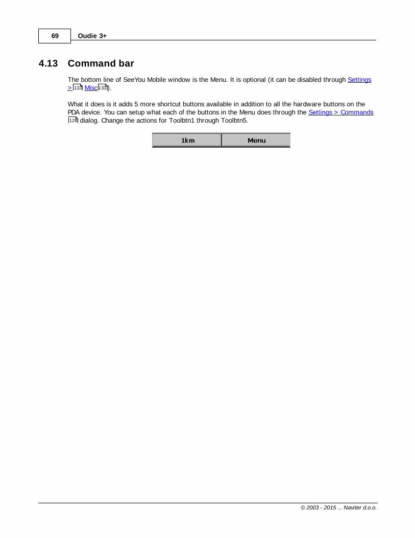
4.13 Command bar
The bottom line of SeeYou Mobile window is the Menu. It is optional (it can be disabled through Settings> Misc ).
What it does is it adds 5 more shortcut buttons available in addition to all the hardware buttons on thePDA device. You can setup what each of the buttons in the Menu does through the Settings > Commands
dialog. Change the actions for Toolbtn1 through Toolbtn5.
133 133
128

Part
V

Oudie 3+71
© 2003 - 2015 ... Naviter d.o.o.
5 Information page
This page gives you some very general information about your position. Use it to report your landingposition or check if everything is setup OK.
The Status panel gives information about GPS and additional pressure data if they are available.Something like GTWAV may be listed after the GPS status message whereG = Groundspeed from GPST = Track heading from GPSW = Vario from a pressure sensor sourceA = Pressure Altitude from a pressure sensor sourceV = True Airspeed from a pressure sensor source
Position panel shows present position (also in UTM coordinates format), local date and time.
Altitude panel shows Altitude QNH, Flight Level altitude and Height over ground
Sunrise and Sunset panel shows local sunrise and sunset (UTC Offset must be set correctly).

Part
VI

Oudie 3+73
© 2003 - 2015 ... Naviter d.o.o.
6 Statistics page
The statistics page gives you detailed information on Thermals and the flight. To change the content ofthe statistics pane, tap on it to switch between. Flight statistics. Task statistics. last 60 minutes statistics
Thermals panel graphically displays the last four thermals where the left most is newest. At the top ofeach bar you can see the Thermal average. The height of each bar represents the entrance anddeparture from each thermal relative to the other four. The number on the right is average for the lastfour thermals. Use it for your MacCready setting if you wish.
Flight statistics gives averages for the Lift, Average speed, Distance flown, circling percentage andduration of flight. Distance is the same as Optimized distance in the "Opt" navbox.Task statistics gives averages achieved since the start of the task.Last 60 minutes statistics gives averages achieved on the Race to goal task or the Optimized task inthe last hour.
You can press the "Back" button to get back to the last map page you have used before Statistics.

Part
VII
Oudie 3+75
© 2003 - 2015 ... Naviter d.o.o.
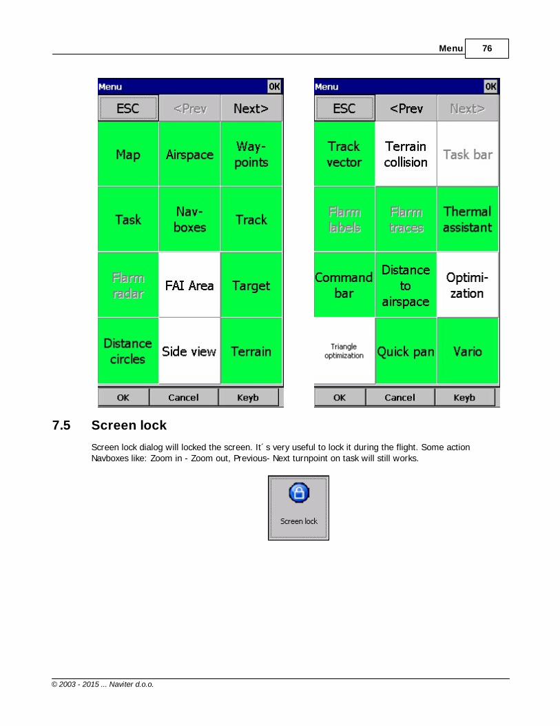
7 Menu
7.1 < Prev and Next >
These buttons show the next and previous page in the Menu .
7.2 Esc
The ESC button in the menu returns the view back to Map view.
7.3 Settings
The Settings button in the Menu opens the Settings dialog where all of the preferences of Oudie 3+can be setup.
Note that some settings like Map and Navboxes are separate for Map 1 and Map 2 views while others likeUnits, Commands etc. are unique through the whole application.
7.4 Display options
You can control what is visible on the Map page . All items which can be made visible or invisible inOudie 3+ are listed in this dialog:
75
105
59
Menu 76
© 2003 - 2015 ... Naviter d.o.o.
7.5 Screen lock
Screen lock dialog will locked the screen. It´s very useful to lock it during the flight. Some actionNavboxes like: Zoom in - Zoom out, Previous- Next turnpoint on task will still works.

Oudie 3+77
© 2003 - 2015 ... Naviter d.o.o.
Tu unlock the screen press the Menu button and confirm this by clickin on the upper side of screen. Seescreenshot below:

Menu 78
© 2003 - 2015 ... Naviter d.o.o.
7.6 Map orientation
Opens a dialog which lets you choose from these different map displayoptions:. Circling North map is turned track up in straight flight and north upwhen circling. North Up where top of the display is always true North. East Up where true East is at the top of the screen. South Up where true South is at the top of the screen. West Up where true West is at the top of the screen. Goal Up sets up the display so, that the point you are navigating to isalways at the top of the screen. Track Up puts your current track towards the top of the screen. Heading Up puts your current heading towards the top of the screen.Heading is calculated by subtracting Wind vector from the Track vector
. Pan mode is a special mode where you can freely move around the map, zoom in, zoom out androtate the map to explore some details along the course.
To move around the map in Pan mode you simply drag your finger over the screen and the map will

Oudie 3+79
© 2003 - 2015 ... Naviter d.o.o.
follow your finger. To rotate the map drag your finger in the bottom 10% of the screen left/right. Themap will again follow your finger, but this time it will rotate around the center point of the screen. If youwill not move map in Pan mode for 10 seconds the Map orientation will change back to what it wasbefore you started to pan.
There is a shortcut for this dialog if you tap with your finger on the North Arrow indicator.
See also:North arrow symbol
7.7 Add Waypoint
You can use the Add Waypoint dialog to add a waypoint on thefly.
You are first taken to a Map window with a white notification at the top. Click anyhwere to add awaypoint at that location. Or click on the notification to add a waypoint at your current location.
63

Menu 80
© 2003 - 2015 ... Naviter d.o.o.
Then you are taken to a window where you can set the Waypoint name and other properties. Use the ++, +, - and -- buttons to change values quickly and without the use of the keyboard. Click GOTO if youwould immediately like to navigate to the newly created waypoint.
See also:Details overview 87

Oudie 3+81
© 2003 - 2015 ... Naviter d.o.o.
UTM CalculatorThis tool converts usual coordinate format to UTM format or vice versa.

Menu 82
© 2003 - 2015 ... Naviter d.o.o.
7.8 Zoom
The Zoom dialog lets you choose from several predefined values(depending on the units). The value represents the width of theSeeYou Mobile window.
2km, 5km ... 35km, 50km ... are fixed zoom settings. Setting represents the width of the Map window.Depending on the units, it can be in either kilometers, statute or nautical miles.Target is a special kind of Zoom where the application determines what width of the Map window to useto keep the target and the sailplane on the screen all the time.

Oudie 3+83
© 2003 - 2015 ... Naviter d.o.o.
7.9 Wind
This dialog lets you see the wind in the third dimension as well asquickly adjust the wind for either one or several layers.
To change the wind, 1. select a layer or several layers by dragging over the left side of the dialog2. draw a wind vector in the square in the lower right corner3. longer line means stronger wind. Direction of the movement determines direction of the wind4. If needed, adjust Direction and Speed with the buttons in the lower part of the display5. tap Apply, then OK.
Wind is calculated using three methods in SeeYou Mobile. Position drift when Lat/Lon are the only available data. Groundspeed difference when groundspeed and track are received from the GPS. Combination of Groundspeed and straight flight when true air speed is received from the instrument. Inthis case, the wind is updated in straight flight as well.

Menu 84
© 2003 - 2015 ... Naviter d.o.o.
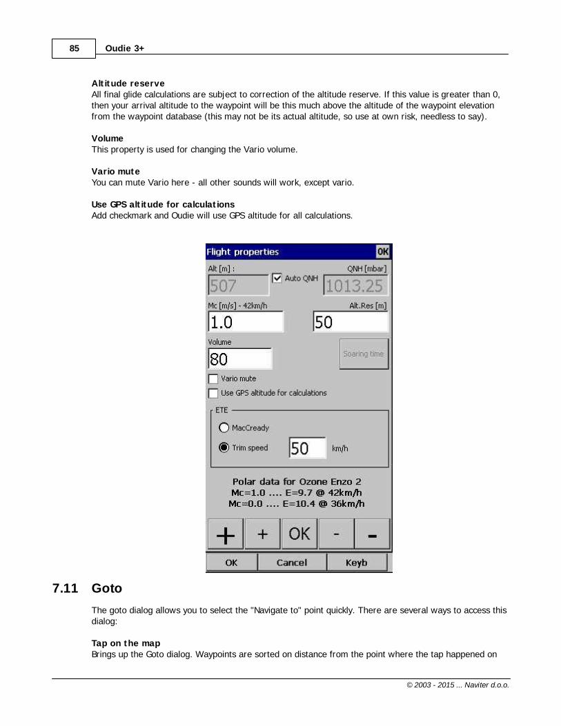
7.10 Volume & Altitude
Take-off altitudeBy changing this setting you can change your take-off altitude. Setting upthis value correctly is essential for correct final glide indications. Whenthere is a waypoint or the terrain map with elevations in vicinity, there isa suggestion at what to set up in the top line of this dialog.
Auto QNH will take the best possible guess at what your altitude is anduse that as your QNH setting. In order for this feature to work reliablyplease remember to turn the Oudie 3 on at least 3 minutes beforetakeoff.
QNHBy changing the QNH value you can change the pressure at start or change the QNH in flight to correctthe change in pressure.
MacCreadyYou can setup the MC setting here. The optimum value for the MC setting can be derived from thestatistics page and other Navboxes.
Oudie 3+85
© 2003 - 2015 ... Naviter d.o.o.
Altitude reserveAll final glide calculations are subject to correction of the altitude reserve. If this value is greater than 0,then your arrival altitude to the waypoint will be this much above the altitude of the waypoint elevationfrom the waypoint database (this may not be its actual altitude, so use at own risk, needless to say).
VolumeThis property is used for changing the Vario volume.
Vario muteYou can mute Vario here - all other sounds will work, except vario.
Use GPS altitude for calculationsAdd checkmark and Oudie will use GPS altitude for all calculations.
7.11 Goto
The goto dialog allows you to select the "Navigate to" point quickly. There are several ways to access thisdialog:
Tap on the mapBrings up the Goto dialog. Waypoints are sorted on distance from the point where the tap happened on

Menu 86
© 2003 - 2015 ... Naviter d.o.o.
the Map screen. This way it is easy to select the waypoint you were trying to "tap" even though youcouldn't tell them apart in the Map view due to the Zoom level.
Through the menuIf the Goto dialog is accessed through Menu > Goto, waypoints are sorted first on type, then distance.This is the Near Airport function of Oudie 3+.
Pressing the Details button will open a new window where you can read waypoint details and editwaypoint properties. It will close automatically after 10 seconds or when you press the OK/Goto button.
Since the waypoint list may be huge there is a quicker way to accessing a particular point alphabeticallyby Filtering the points. When the waypoints are filtered, the Filter caption is highlighted in thecommand bar (see screenshot below).
At the bottom of the screen, immediately above the menu, three recently used waypoints are displayed.Landable points are colored green or yellow if they are reachable. At the top of the screen you canchoose between clearing the target all together, navigating back to takeoff location or back to Soaringbegin (useful for closing a triangle for example).
89

Oudie 3+87
© 2003 - 2015 ... Naviter d.o.o.
See also:Details overviewEdit WaypointEdit Description Waypoint filter
7.11.1 Details overview
This window opens when you click on the Details menu option in the Goto dialog or Cursor Info -Waypoints dialog. It displays the general information about a waypoint.
It also allows you to edit and delete waypoint properties on pages Edit Waypoint and Edit Description. You can access these pages with the ">>" and "<<" buttons in the command bar.
87
88
88
89
85
61
88
88

Menu 88
© 2003 - 2015 ... Naviter d.o.o.
See also:Goto dialogDetails overviewEdit WaypointWaypoint filter
7.11.2 Edit Waypoint
You may edit and delete waypoints on this screen.
This window opens when you click on the Details menu option in the Goto dialog or Cursor Info -Waypoints dialog and press the ">>" button once.
Use the ++, +, - and -- buttons to change values quickly and without the use of the keyboard.
85
87
88
89
85
61
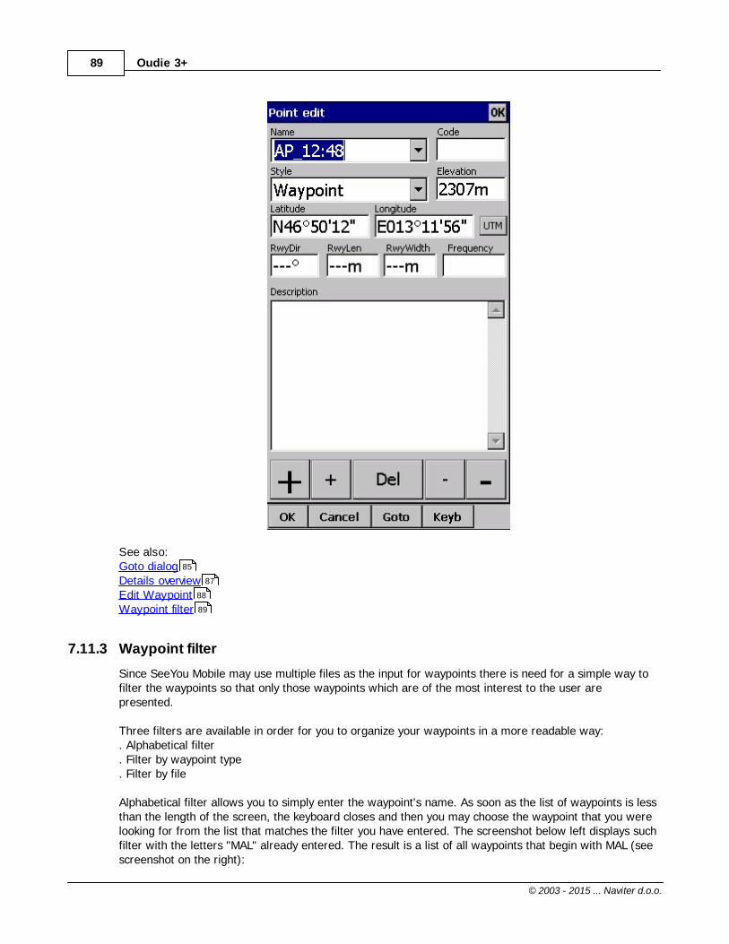
Oudie 3+89
© 2003 - 2015 ... Naviter d.o.o.
See also:Goto dialogDetails overviewEdit WaypointWaypoint filter
7.11.3 Waypoint filter
Since SeeYou Mobile may use multiple files as the input for waypoints there is need for a simple way tofilter the waypoints so that only those waypoints which are of the most interest to the user arepresented.
Three filters are available in order for you to organize your waypoints in a more readable way:. Alphabetical filter. Filter by waypoint type. Filter by file
Alphabetical filter allows you to simply enter the waypoint's name. As soon as the list of waypoints is lessthan the length of the screen, the keyboard closes and then you may choose the waypoint that you werelooking for from the list that matches the filter you have entered. The screenshot below left displays suchfilter with the letters "MAL" already entered. The result is a list of all waypoints that begin with MAL (seescreenshot on the right):
85
87
88
89
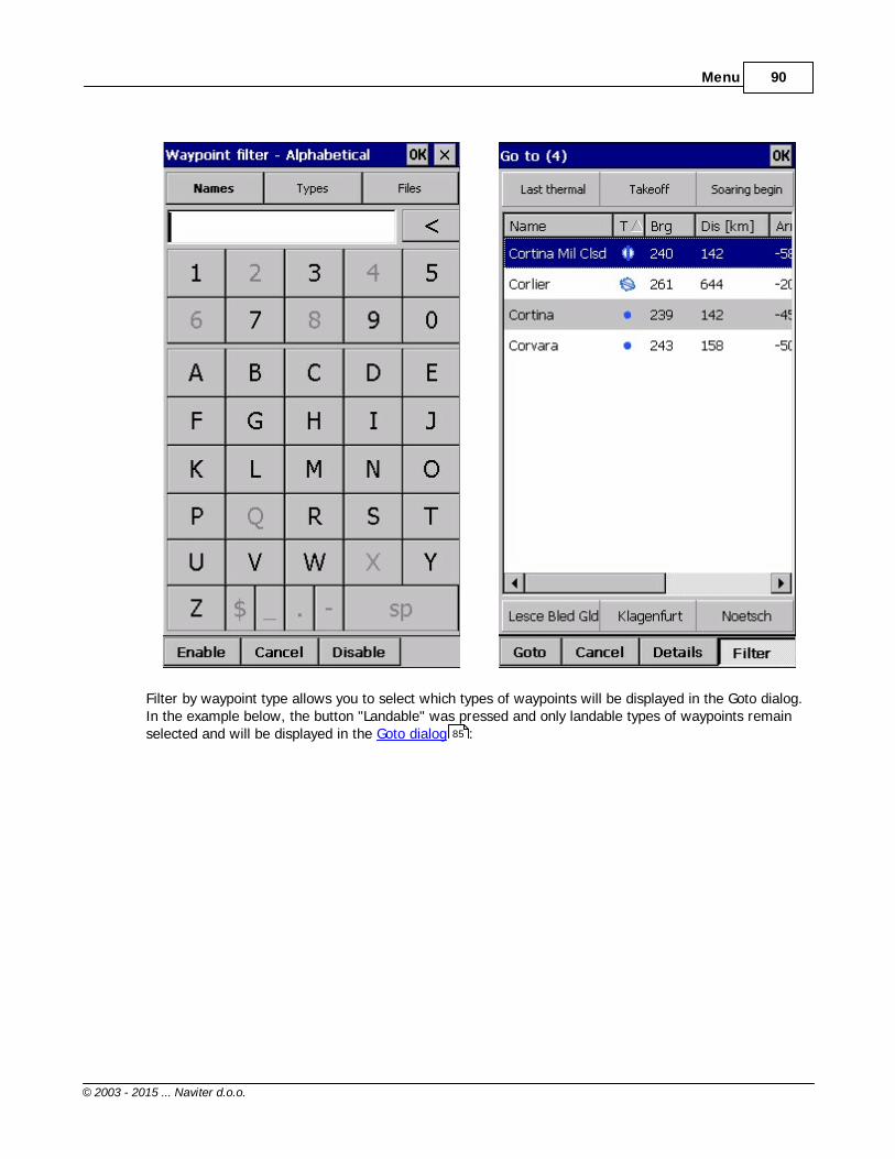
Menu 90
© 2003 - 2015 ... Naviter d.o.o.
Filter by waypoint type allows you to select which types of waypoints will be displayed in the Goto dialog.In the example below, the button "Landable" was pressed and only landable types of waypoints remainselected and will be displayed in the Goto dialog :85
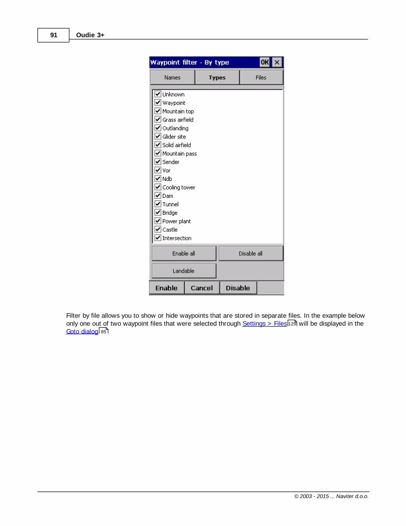
Oudie 3+91
© 2003 - 2015 ... Naviter d.o.o.
Filter by file allows you to show or hide waypoints that are stored in separate files. In the example belowonly one out of two waypoint files that were selected through Settings > Files will be displayed in theGoto dialog
129
85

Menu 92
© 2003 - 2015 ... Naviter d.o.o.
See also:Goto dialogDetails overviewEdit WaypointWaypoint filter
7.12 Task
The task dialog allows you to edit and enter the task in list view.
85
87
88
89

Oudie 3+93
© 2003 - 2015 ... Naviter d.o.o.
You can edit the task either in . List view. Map view
7.12.1 List edit
Entering the task is best done in list view. Open the keyboard to start entering waypoint name. Oudie 3will automatically suggest the first waypoint in alphabetical order. Use the right/left button to changewaypoint name in alphabetical vicinity of what you had entered. Please read the Gettings Started chapter Entering and flying the task.
By tapping on the Edit button Edit point dialog opens where you can setup preferences of theObservation Zone (cylinder, line, FAI sector), Start speed section and End speed section etc. Use Insertand Delete buttons to change the Task.
Options button gives you quick access and overview of the task settings.
From the command bar you can choose. OK to accept any changes. Cancel to discard any changes. Tools to Edit point , Delete point, Insert point, Move point up and down, Invert task, Load task ,
93
94
95
97
95 96

Menu 94
© 2003 - 2015 ... Naviter d.o.o.
Save task, Clear task or setup Task Options .. Keyb to start typing waypoint names
A warning dialog will be issued if finish altitude is set to zero. This is to protect you from making finalglides to the wrong altitude.
7.12.2 Map edit
The same simple philosophy from graphical task editing in SeeYou has been implemented in thesoftware.
Tap & Move anywhere except on a waypoint to move the map.Tap & Move on a Waypoint to move it. FAI Area is drawn to easily fly an FAI TriangleTap & Hold on a Waypoint to delete it from the task.Tap & Hold on a Leg to insert a point to this leg.Tap & Hold anywhere on the map except on a leg and on a waypoint to append a waypoint to the endof the task.
. Use Zoom (100km) to change zoom, then Tap&Move the map to pinpoint the position of the freewaypoint.. OK to accept any changes. Cancel to discard any changes. Edit to Edit point , Delete point, Insert point, Invert task, Copy task , Delete task or
97
95 96
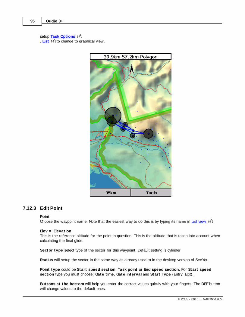
Oudie 3+95
© 2003 - 2015 ... Naviter d.o.o.
setup Task Options .. List to change to graphical view.
7.12.3 Edit Point
PointChoose the waypoint name. Note that the easiest way to do this is by typing its name in List view .
Elev = ElevationThis is the reference altitude for the point in question. This is the altitude that is taken into account whencalculating the final glide.
Sector type select type of the sector for this waypoint. Default setting is cylinder
Radius will setup the sector in the same way as already used to in the desktop version of SeeYou.
Point type could be Start speed section, Task point or End speed section. For Start speedsection type you must choose: Gate time, Gate interval and Start Type (Entry, Exit).
Buttons at the bottom will help you enter the correct values quickly with your fingers. The DEF buttonwill change values to the default ones.
97
93
93

Menu 96
© 2003 - 2015 ... Naviter d.o.o.
7.12.4 Load task
Load task dialog is accessed through Menu > Task > Tools > Load task... You can access it through both List and Map view of the Task.
Select a task from your database and press OK to make it your active task. Press Cancel to discard anychanges. You pressed Help to get here.
93 94

Oudie 3+97
© 2003 - 2015 ... Naviter d.o.o.
7.12.5 Task options
Task options dialog is accessed through Menu > Task > Tools > Options...
DescriptionYou can name a task. This is particularly useful at a competition briefing where you can name it Task A(or 1) and Task B (or 2).
Start speed sectionIn this box you can set Start speed section waypoint, gate time and interval and number of intervals. ForRace to goal tasks is Start on entry set to default.
End speed sectionIn this box you choose the end of speed section waypoint and Cone.
Task deadline timeYou can put task deadline here. Oudie 3 will give you a warning 15 minutes before Task deadline time.
Asigned area task time is essential for flying the Assigned Area tasks. It is used to calculate requiredspeed to finish as well as time difference on task.
The MC (MacCready) panel allows you to set your average lift in the edit box and see what your

Menu 98
© 2003 - 2015 ... Naviter d.o.o.
theoretical speed will be if you fly according to the MacCready theory.
The Navigate by shortest route check box will automatically navigate you on task by shortestoptimized distance.
Use the + and - buttons to quickly change values.
7.13 Next map
If you are currently viewing Map 1 it changes the view to Map 2 and vice versa.

Oudie 3+99
© 2003 - 2015 ... Naviter d.o.o.
7.14 Info page
See Information page
7.15 Statistics
See Statistics page
7.16 About
7.17 Exit
Pressing this button quits the application.
Before you exit, the program will ask you whether or not you wish to:. save the current profile changes. save changes to the waypoints and tasks. save changed or added Flarm aliases. Finish the flight by signing the IGC file with SeeYou G-record
71
73

Menu 100
© 2003 - 2015 ... Naviter d.o.o.
7.18 Save Settings
Once you have setup Oudie 3+ for your flight you may want to savethe settings without exiting SeeYou Mobile.

Oudie 3+101
© 2003 - 2015 ... Naviter d.o.o.
7.19 Thermal assistant
See Using Thermal Assistant .
7.20 Switch Profile
The switch profile icon shuts down Oudie 3+ and runs it again so you can choose another profile.
See also
28

Menu 102
© 2003 - 2015 ... Naviter d.o.o.
Using Profiles
7.21 Logbook
The logbook displays a list of flights written by your Oudie 3+. It also displays information about theglider and the pilot if it is stored in the IGC file.
7.21.1 Statistics, replay and upload flight
At end of each flight some statistics is written to IGC file for later use. To see statistic from your flight go to Menu > Next > Logbook > select flight >Tools > Statistic.
If you wish you can replay your flight as well directly from Logbook: Menu > Next > Logbook > selectflight > Tools > Replay flight .
21
18

Oudie 3+103
© 2003 - 2015 ... Naviter d.o.o.
Your flight can also be uploaded to SeeYou Cloud and Soaring Spot. Take a look at Connect to SeeYouCloud and Connect to Soaring Spot . 55 56

Part
VIII

Oudie 3+105
© 2003 - 2015 ... Naviter d.o.o.
8 Settings
The Settings dialog has an array of Pages where all of the Oudie 3+ preferences can be setup. Note thatsome settings like Map and Navboxes are separate for Map 1 and Map 2 views while others like Units,Commands etc. are unique through the whole application.
Available pages are. Map where display of the vector map is setup. Airspace where display of airspace and airspace warning is setup. Waypoints page controls the way waypoints are displayed. Track & Target page sets up the trace, vario colors of the displayed trace. Opt page (short for Optimization) lets you setup how the optimizations are calculated. Task page sets up the observation zones and other task options. Navboxes page lets you choose which navboxes to display and control their appearance. Symbols page allows you to choose from symbols for the map display. Warnings page sets up airspace and altitude warnings. Thermal page sets up the Thermal assistant. Polar page has all the controls to choose the polar for your glider. Units by your preference. Fonts page changes the appearance of the text on the screen. Input page lets you select between GPS, Simulator and File replay mode. Commands page reassigns tasks to all buttons of your PDA and SeeYou Mobile. Menu page lets you control the content of the main Menu. Files page has shortcuts to the terrain, waypoint and airspace files. Log page sets up the header for the IGC file. User interface by your preference. Miscellaneous page has all the rest. Hardware page controls communication to GPS with proprietary sentences. Vario page sets up the vario preferences. Oudie Live page controls communication with your smartphone for access to external servers.
Once you are in the Settings dialog you can use the big Left/Right button on the PDA to change betweenpages. If you press and hold it, it will scroll through the pages. If you need to quickly find the last page,just press and hold it until it's there.
8.1 Map
This dialog allows you to setup the appearance of the map in Map view . SeeYou Mobile uses CITmaps for rendering the terrain. It is the same map as in the desktop version of SeeYou.
Show map check box will enable the display of the Vector map if checked.
TerrainYou can choose from several levels of detail of the terrain which is being rendered. When terrain is Off,you will still see Water bodies, Roads, Railroads, Towns and labels on the screen. With the setting atLow contour lines will appear approximately 300m apart. With the setting at Medium, contour linesappear about 100m apart. With the setting at High, you get exactly what you are used to in the desktopSeeYou version.
SchemeSeveral color schemes are preloaded in a new installation. It is easier to see how each one looks if youlook at it in the desktop SeeYou. We recommend "High contrast" for mountaneous terrain, ICAO for just
105
107
108
110
111
112
113
119
120
121
123
124
125
126
128
128
129
131
131
133
134
136
137
59

Settings 106
© 2003 - 2015 ... Naviter d.o.o.
general navigation and Open Street Maps color scheme for the Flatlands.
If Custom color scheme is chosen you get to define your own colors and other properties for the mapobjects.
Background colorFor each cheme you can select background color.
Shade mapThis function will shade map.
Draw surface objects will enable drawing woods and grass, glaciers, fields if newer Open Street Mapsare used.
8.1.1 Scheme properties
Scheme Properties dialog lets you change the color scheme for the topographic features of the map.
Object properties allows you to change the zoom level, transparency and color for each of thetopographic features in the combo box.
You can also copy settings from another scheme with Copy from scheme function.

Oudie 3+107
© 2003 - 2015 ... Naviter d.o.o.
8.2 Airspace
In this dialog, you can setup airspace display and Warnings.
In the Type panel you can setup how airspace is displayed. You should setup each type of airspaceseparately. Choose an airspace type from the drop down list. Choose until which zoom level it is visiblefrom the Zoom drop down list. By checking the Warn me check box you will be warned before enteringthis type of zone. Choose whether or not a zone should be filled from the Fill drop down list. Chose aColor for the airspace type from the drop down list. Fill transparencies could be set from 0 to 100% in10% step.
Each airspace may be presented with its label (name). Choose until which zoom this label is visible fromthe Labels zoom drop down list.
If Fill alarmed zones is checked, airspaces for which an alarm was triggered will be coloredtransparently.If Hide inactive zones option is checked, then an airspace zone will be hidden from the Map pagewhen dismissed.If Show airspace check box is checked, then airspace will be displayed in the Map view .Combo box Hide airspace above enables you to exclude airspace with lower limit higher than theheight you select to show on the map screen. This helps declutter the screen in complex airspace.
59
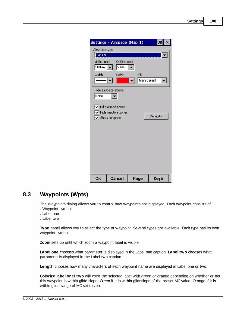
Settings 108
© 2003 - 2015 ... Naviter d.o.o.
8.3 Waypoints (Wpts)
The Waypoints dialog allows you to control how waypoints are displayed. Each waypoint consists of . Waypoint symbol. Label one. Label two
Type panel allows you to select the type of waypoint. Several types are available. Each type has its ownwaypoint symbol.
Zoom sets up until which zoom a waypoint label is visible.
Label one chooses what parameter is displayed in the Label one caption. Label two chooses whatparameter is displayed in the Label two caption.
Length chooses how many characters of each waypoint name are displayed in Label one or two.
Colorize label one/two will color the selected label with green or orange depending on whether or notthis waypoint is within glide slope. Green if it is within glideslope of the preset MC value. Orange if it iswithin glide range of MC set to zero.

Oudie 3+109
© 2003 - 2015 ... Naviter d.o.o.
Single line label will display the label one and two in a single line.
Declutter landables prevents the names of the landable waypoints from overlapping. Only the one withthe safest final glide will be shown
Declutter non-landables prevents the names of the non-landable waypoints from overlapping.
Select waypoint by code
Max number of visible symbols lets you setup how many waypoint symbols you wish to havedisplayed with their icons before they become points.
Cursor sort allows you to select how the waypoints are sorted when you use the Up/Down key (bydefault) to change the Target waypoint. The default setting is that waypoints are sorted on Name, butyou can select to sort them either on Name, Code, Style, Course, Distance, Arrival Alt, Required L/D or inthe same order as currently selected in the Goto dialog.
Show waypoints checkboxs lets you turn waypoints on/off.
Defaults button will return factory settings if pressed.

Settings 110
© 2003 - 2015 ... Naviter d.o.o.
8.4 Track & Target
Setup the appearance of the flight on Map page.
Flight trace panel lets you choose the Color and Width of the trace of the flight through the comboboxes. Choose the tail Length in minutes. Flight track is colored regarding the chosen style. If Showtrack checkbox is not checked, then the trace will not be drawn.
Show current track vector lets you draw a line ahead of the glider to show your projected flight pathif you continue to fly the current track. You may change the Color, Width and Length of the linethrough the combo boxes. You may choose to disable the display of the current track vector by disablingthe option Show current track vector.
Target is a straight line that connects the glider's current position with the selected navigation goal. Inthe Target panel you can select the Color and Width of this line through the combo boxes. You can alsochoose to show or hide the Terrain collision point and the target line itself. The Terrain collision markeris a red square which is only displayed when there is not enough altitude to reach the target with thecurrent glider settings.
Distance circles helps you to value how far you are from anything on the map.
See also:Flight Trace 65

Oudie 3+111
© 2003 - 2015 ... Naviter d.o.o.
8.5 OLC & FAI area
Optimization panel lets you select the Color and Width of the optimized track. Nr. of points (5 is forOnline Contest, 3 for Net Coupe) and whether or not the Optimized track is shown.
FAI Area panel largely influences the behaviour of the FAI Triangle Assistant.
You may choose the Color and Fill for the FAI Area. Show area checkbox determines whether or notthe FAI area will be displayed in the first place. Note that you can control this option much moreconveniently through the Display Options dialog.
The Rotate button will change where the FAI Area is drawn. If the currently flown triangle is not deepenough it will switch sides over the longest currently flown leg, giving you the option to fly the triangle inthe left or right direction. Once the Triangle is deep enough, it will rotate between the legs so you canaccurately determine where to fly.
Rotate on click refers to the FAI Area when it is drawn on the moving map. A tap on the area willrotate the area as described above.
Show km. lines will draw the curves connecting locations where the triangle has the same distance.
Example shows kilometer lines for Triangles between80 - 140km. If you fly into the violet area, thetriangle will be an FAI triangle.
75

Settings 112
© 2003 - 2015 ... Naviter d.o.o.
See also:. FAI Triangle Assistant
8.6 Setup Task
Observation zone properties are setup with the same philosophy as in SeeYou. You can setup Fill andColor properties for the display of the observation zone on the Map page.
In Observation zone dialog you can separately choose sector type properties for the Start, Waypointand Finish points.
Observation zone style lets you choose the color and width for the waypoint sector. Observationzone fill determines whether or not the sector should be displayed filled or outlined. Also transparencycould be set.
Task style lets you choose the color and width for the line connecting the task waypoints.
Show task will show or hide the task from the Map page.
47

Oudie 3+113
© 2003 - 2015 ... Naviter d.o.o.
8.7 Navboxes
Navigational boxes are one of the most important parts of Oudie 3+. They show all parameters of flight.You have full control over which Navboxes you wish to display, how large and how transparent theyshould be and where they should be located. Note that each Navbox can also function as a button if youassign an "Action" to it.
Navboxes are setup separately for Map 1 and Map 2 views. That is because normally you will want to usethe two map views for two different reasons. One could be general navigation while the other one isapproaching the waypoint where details are important. You will require two different settings for whichNavboxes should be displayed in these conditions.
Through this dialog you can select which of the available Navboxes you wish to display on the active map.
The Combo box allows you to choose from a sub-group of navboxes so you can more easily select orchange the ones you want. One sub-group is also "Currently visible navboxes" for example.
Navigation navboxes:. Target name (Target) = Name of the selected waypoint. Distance to target (Dis) = Distance to the selected waypoint. Steering course (To) = Difference in degrees between Bearing to target and Track over ground
Settings 114
© 2003 - 2015 ... Naviter d.o.o.
. Bearing to target (Brg) = Direction towards the selected waypoint
. Magnetic bearing to target (MagBrg) = Magnetic course to fly to get to the target
. Track over ground (Trk) = Direction of the flight (true)
. Magnetic Track over ground (MagTrk) = Current magnetic course of flight
. Radial (Radial) = Magnetic direction from the waypoint to the current position
. Speed over ground (GS) = Groundspeed. This value is negative if the difference between headingand track is more than 90 degrees. Local time (Time) = UTC time from GPS corrected by time zone set in the Pocket PC. Arrival time (ETA) = Estimated time of arrival to the selected waypoint. Estimated time enroute (ETE) = Estimated time to go to selected waypoint. Nearest airport (Near Apt) = Name of the nearest airport. Tapping on this navbox opens airportproperties dialog. Inverted Distance to target (DisInv) = Distance to selected target in inverted units as currentlyselected units. If your units are kilometers, this distance will be in nautical miles. Dist to TP (DistTP) = The distance from your position to selected center of turnpoint. Distance to OZ (DistOZ) = The shortest distance from your position to currently selected ObservationZone (Cylinder, Line, FAI sector) . Steering course to last thermal (ToLT) = Difference in degrees between Bearing to last thermaland Track over ground. Dist to last thermal (DisLT) = Distance to the last thermal. GPS Status (GPS) = It displays the status of the GPS signal. It can be either NODATA, BAD, OK, 2D,3D/x. Battery info (Bat) = Displays battery status. It can be either Full, Chrg (Charging), Ext (External) or apercentage value of the battery status
Altitude navboxes:. Altitude QNH (Alt) = Altitude above sea level. Flight level (FL) = Altitude above standard atmosphere pressure. Height AGL (Agl) = Altitude above the ground elevation vertically below the glider position. Altitude m QNH (Alt m) = Altitude in meters QNH regardless of the units you are currently using. Altitude ft QNH (Alt ft) = Altitude in feet QNH regardless of the units you are currently using. Altitude QNH 2.5 h = it´s altitude you have been 2,5 h ago from current time.. Ground elevation (Gnd) = Terrain elevation vertically below the glider position. Arrival altitude (Arrival) = Expected Arrival altitude at the selected waypoint calculated by taking thedistance, MC, wind, glider polar, bugs and ballast into account. It is corrected for reserve altitude."Arrival altitude" will be positive when the glider is above the calculated glide slope, and negative when itis below the calculated glide slope.. Required Altitude (ReqAlt) = Estimated altitude loss from current position to target taking into accoutcurrent MC, bugs, ballast and wind settings. Task arrival altitude (tArr) = Arrival altitude to goal from your position with taking into accountcurrent MC, bugs, ballast and wind settings.. Task required altitude (tReqAlt) = Altitude required to complete the task
Final glide navboxes:. Flown L/D (Cur.L/D) = Current glide ratio estimated over the last two minutes of flight. Required L/D (Req. L/D) = Required glide ratio to reach the selected waypoint. Thermal L/D (Ther. L/D) = Glide ration since last circling phase finished. Arrival altitude (Arrival) = Expected Arrival altitude at the selected waypoint calculated by taking thedistance, MC, wind, glider polar and ballast into account.. Required Altitude (ReqAlt) = Estimated altitude loss from current position to target taking intoaccount current MC, ballast and wind settings. Required Mc (Req.Mc) = MacCready ring setting which will allow you to final glide exactly to theTarget. It shows Arrival Altitude when Arrival altitude for MC=0 is less than zero

Oudie 3+115
© 2003 - 2015 ... Naviter d.o.o.
. Task arrival altitude (tArr) = Expected Arrival altitude at the the end of a task calculated by taking thedistance, MC, wind, glider polar and ballast into account.. Task required altitude (tReqAlt) = Estimated altitude loss from current position to end of a tasktaking into account current MC, ballast and wind settings . Task required L/D (tL/D) = Required glide ratio to complete the task
Speed navboxes:. Speed over ground (GS) = Groundspeed. This value is negative if the difference between headingand track is more than 90 degrees. True airspeed (TAS) = Groundspeed corrected with indicated wind, if no pressure data is available. Indicated airspeed (IAS) = Indicated airspeed from external device. Speed to Fly (STF) = Speed to fly according to MC theory which takes MC setting and sink intoaccount.. Task speed (Tsk.Sp.) = Speed on task until the present position. Task required speed (tReq.Sp) = Average speed you need to achieve to complete the task inside theTask time. Speed Last hour (60'.Sp) = Average speed achieved in the last 60 minutes
Vario navboxes:. Thermal vario (VarT) = average vario since beginning of circling. Average vertical speed (VarA) = average vario for the last 20s. Vertical speed (Vario) = current vario reading. Netto vertical speed (Netto) = Variometer reading corrected for the sink of the glider according tothe selected polar
Wind navboxes:. Current wind (Wind) = Current wind measurment. Current wind component (cWind) = Wind component in current direction of the flight. Positive valuesare tailwind, negative values are headwind. Two numbers are displayed. First number is differencebetween groundspeed and true airspeed. The second one is wind component derived from the calculatedwind at current altitude. When the two are significantly different you will know not to rely on thecalculated wind strength
Airspace navboxes:. Nearest airspace - Horizontally (Near AS.H) = Distance to horizontally nearest airspace where youare not "inside". The caption of this navbox will show airspace name. Tapping on this navbox willtemporarily arm this airspace so you can turn it off if you wish.. Nearest airspace - Altitude (Near AS.V) = Relative altitude to the horizontally nearest airspace. Itcan be either negative if you are below the lower limit of the airspace, positive if you are above theupper limit of the airspace or "Inside" if your altitude is in between the lower and the upper limit of theairspace in question.. Nearest airspace - Vertically (Near AS.V) = Relative altitude to the airspace at the location of theglider. It can be either negative if you are below an airspace , positive if you are above an airspace or"Inside" if your altitude is in between the lower and the upper limit of the airspace in question.
Task navboxes:. Task remaining distance (tDis) = Distance remaining on the task. Task arrival altitude (tArr) = Altitude required to complete the task. Task required L/D (tL/D) = Required glide ration to complete the task. Task arrival time (tETA) = Estimated time of arrival to the finish. Task estimated time (tETE) = Estimated time to go on task. Task remaining time (tRemain) = Remaining time until task time elapses. Task Delta time (tDelta) = Task established time - Task remaining time
Settings 116
© 2003 - 2015 ... Naviter d.o.o.
. Speed to gate/Task speed (tsk.Sp) = required speed for optimal arrival on gate in time
. Task required speed (tReq.Sp) = Average speed you need to achieve to complete the task inside theTask time
. Task gate time (Gate) = opening time of gate (depends on the UTC Offset Setting)
. Task time to go (TTG) = optimal arrival time for the start gate
. Conical end speed section (Cone) = Main value is optimum speed to reach cone as quickly aspossible. In third line is calculated minimum required thermal which will allow you to reach cone sooneras in straight flight.
Statistics navboxes:. Thermal vario (VarT) = average vario since beginning of circling. Optimized distance (Opt) = Optimization over a preselected number of waypoints (default is OLCoptimization). Closed optimized distance (cOpt) = Optimization of flight if you return back to the point of takeoff. Triangle distance (Tri) = Triangle optimization. . Speed Last hour (60'.Sp) = Average speed achieved in the last 60 minutes. Flight time = Flying duration. Engine running = will reset optimization when "engine" is stopped. Tap on the navbox changes thestate of the "engine"
Action buttons:There are a few "dummy" navboxes which are used on devices with few hardware buttons. Due to thelack of hardware buttons you may place "software" buttons in the shape of a Navbox on your screen. Thefollowing "buttons" are supported:. MC increase will increase the MacCready value by 0.1 m/s or 0.2 kts. MC decrease will decrease the MacCready value by 0.1 m/s or 0.2 kts. Volume increase will increase the Volume of the device. Volume decrease will decrease the Volume of the device. Map 1 page will switch view to Map 1. Map 2 page will switch view to Map 2. Statistics page will switch view to Statistics page. Info page will switch view to Info page. Zoom in. Zoom out. Sideview will turn ON or turn OFF Side view.. LiveTrack24 shows time from last successful communication with LiveTrack24 server . Soaring Spot shows time from last successful communication with Soaring Spot server
When Select multiple is checked you can tap on a single navbox to select it and keep selected the onesthat were already selected. To select a number of navboxes at once, tap, hold and move the stylus. Select All quickly selects all navboxes, so you can use the Edit button.
Edit... button allows you to change common values of the navboxes. Select single or several navboxes bydragging the stylus over the navbox names. Then press Edit to select the Number of lines you wishthem to have and whether or not you want the selected navboxes to be Transparent.
You can assign an Action to each of the Navboxes. Action is performed when you tap on a specificnavbox. By default, only Team navbox has an action assigned to it. Tapping on the Team navbox willopen the Team dialog where you can enter your teammate's position code.
Auto Arrange check box will rearrange new navboxes so, that they stack at the bottom of the screen.
124
59
59
73
71

Oudie 3+117
© 2003 - 2015 ... Naviter d.o.o.
Show navboxes check box will hide navboxes if not checked.
8.7.1 Edit
While you editing selected or group of selected NavBoxes properties dialog will show you sample support.

Settings 118
© 2003 - 2015 ... Naviter d.o.o.
Number of lines determines how many lines a navbox will have on the screen. A navbox consists ofthree lines:. Title line (Line 1) which is black by default and has white font. Data line (Line 2) with white or transparent background and black text by default. Units line (Line 3) with units or other sub data to the main data line.
When Number of lines is one, only the Data line (Line 2) will be displayed. When you select two Title and Data lines will be displayed (Line 1 and Line 2). When you select three all three lines will be displayed.
SizeThere are three different sizes available: Normal, Large, Huge. For some Navboxes is usefull to set also Width; for example Target name.
Colors panel accounts controls the looks of the Navboxes. You can change the colors for. Background. Frame. Title line. Data line. Units line

Oudie 3+119
© 2003 - 2015 ... Naviter d.o.o.
Note that you can change the Navbox colors separately for each Navbox. Select a group of navboxes inMenu > Next > Navboxes, then press Edit to edit the Color and Number of lines settings for severalnavboxes at once. By same system you can set size of Navboxes.
If the checkbox for Transparent is selected, the Data and Units line will be transparent. With the Fillcombo box you can control how transparent the navboxes are from 0 to 100 % in 10 % step. TextOutline property could be used for Navbox text or by default with tap on Value only button.
Allow drag check box if checked will allow you to place any Navbox anywhere on the screen. To moveit, Tap on the Navbox in question, then move it to a new spot. Note that you can move the North Arrow,Glider symbol, Wind indicator and Glideslope indicator in the same way.
With the Fill combo box you can control how transparent the navboxes are. 0% transparent navboxes'background color is solid, you can not see through it.
8.8 Symbols
You can choose the preferences for these symbols:. Aircraft,. Wind,. Orientation,. Final glide,. Scale,. Task button,. Speed to Fly,. Vario.
Visible property shows or hides a specific symbol.
Transparent property makes the symbol outlined if checked.
Allow drag option lets you choose whether or not the symbol can be moved around the screen.
Reset position button will bring the selected button back to its default position on the screen.
The Size slider selects the size of each symbol.
Type combo box lets you choose from several options for a particular symbol.
Legend option is available only for Vario symbol.
Vario symbol will display an analogue Vario on an Oudie IGC
All Symbols could be outlined with white color.

Settings 120
© 2003 - 2015 ... Naviter d.o.o.
8.9 Warnings
There is three types of warnings in SeeYou Mobile
1. Airspace warnings2. Altitude warnings3. Flarm warnings
Airspace Warning is activated by two triggers. First warning is when the projected point of the flight isinside a sector. Sector is outlined bold red, so you can clearly identify it on the screen. The position ofthe glider is projected for the value in secons ahead of the current position. This value is setup in Time[s] setting.
Second Airspace warning appears when you fly closer than the preselected Distance from the Airspaceor when your altitude is less than Alt.res different from the airspace boundaries. A continous soundwarning and whole-screen warning appears.
Altitude warning is a general warning, useful for example when there is a maximum altitude set for acompetition day or 18.000ft for the USA. When you come close to the airspace, you get a beep and thered banner much like the airspace warning.
Flarm warning is special in that it reads the information from the Flarm device and then uses voice

Oudie 3+121
© 2003 - 2015 ... Naviter d.o.o.
imitation in order to pass this information to the pilot.
See also:How Airspace warning works
8.10 Thermal
Thermal assistant continuously analyzes the thermal when you are circling. You can decide when youwould like to be warned about potential better lift in one part of the circle.
Vario variance is the difference between squares of deviations and the mean vario value. The bigger thedifference, the more possible it is that if you move your circle in the direction of the strongest lift that theaverage climb will increase.
In the Menu > Settings > Thermal you can determine at which vario variance you would like the visualThermal Assistant and Audio thermal assistant will appear. For the audio you can also select how muchbefore the maximum the thermal assistance will whistle.
You may choose between Bubbles and Ring representation of the graph which shows the best part of thelift. Ring is default setting. If Hide map option is choosen you will not see map while Thermal Assistant isturned ON.
Thermal Assistant is automatically activated after 120 degrees turn. When you are flying out from
25
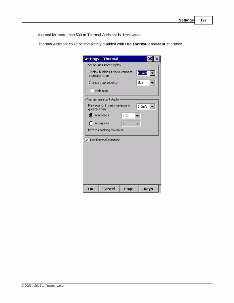
Settings 122
© 2003 - 2015 ... Naviter d.o.o.
thermal for more than 500 m Thermal Assistant is deactivated.
Thermal Assistant could be completely disabled with Use thermal assistant checkbox.

Oudie 3+123
© 2003 - 2015 ... Naviter d.o.o.
See also:Getting started - Thermal AssistantMenu (with a shortcut to show the Thermal Assistant regardless of the variables)
8.11 Polar
The Polar dialog lets you enter your glider polar data into SeeYou Mobile. These data is essential forperforming the final glide calculations.
You can access a list of pre-generated polars by clicking on the "List..." button.
Glider field lets you enter a name for the polar.
Min. load sets up the minimum wing loading of the glider while Stall speed tells SeeYou Mobile aboutthe assumed stall speed of the glider.
a, b and c are parameters of the quadratic equation which is a mathematical approximation of theglider's actual performance.
If you enter Reference weight, Max weight, Empty weight and Pilot weights for the glider you will
28
75
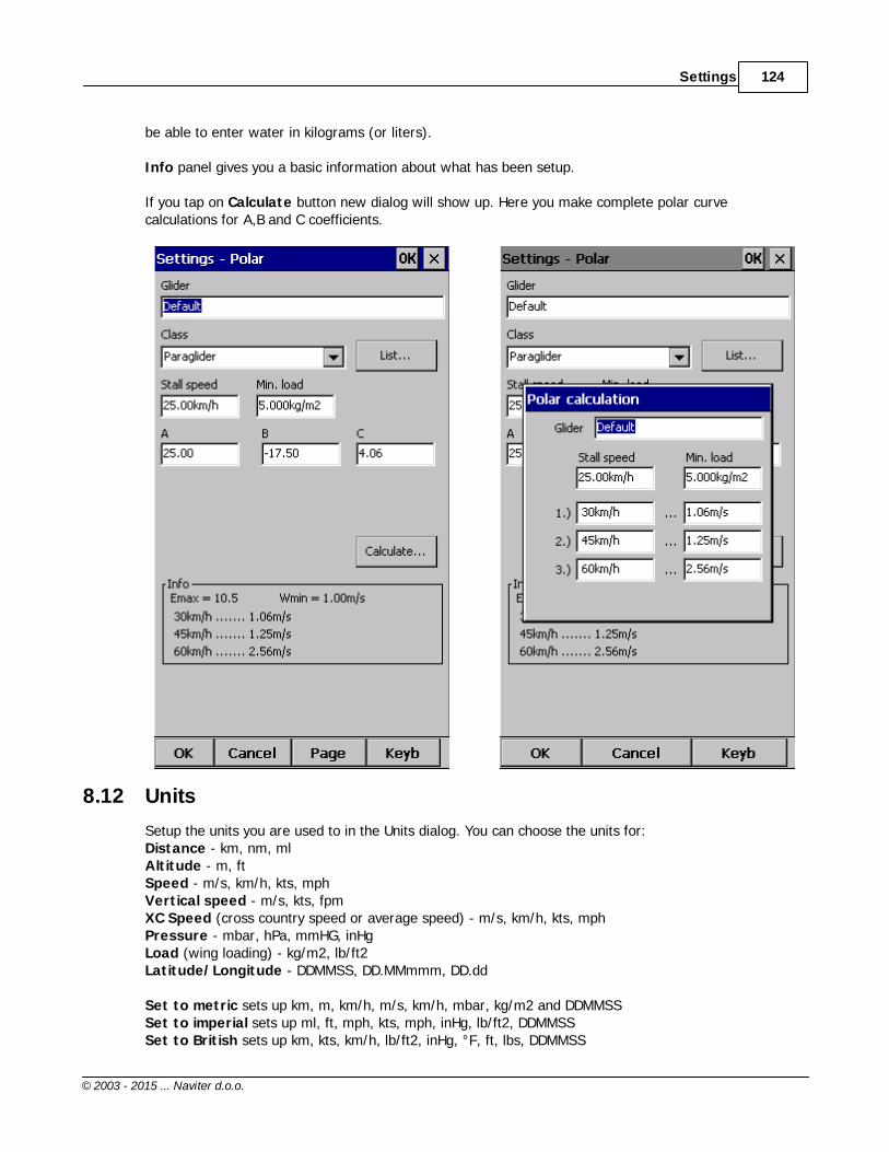
Settings 124
© 2003 - 2015 ... Naviter d.o.o.
be able to enter water in kilograms (or liters).
Info panel gives you a basic information about what has been setup.
If you tap on Calculate button new dialog will show up. Here you make complete polar curvecalculations for A,B and C coefficients.
8.12 Units
Setup the units you are used to in the Units dialog. You can choose the units for:Distance - km, nm, mlAltitude - m, ftSpeed - m/s, km/h, kts, mphVertical speed - m/s, kts, fpmXC Speed (cross country speed or average speed) - m/s, km/h, kts, mphPressure - mbar, hPa, mmHG, inHgLoad (wing loading) - kg/m2, lb/ft2Latitude/Longitude - DDMMSS, DD.MMmmm, DD.dd
Set to metric sets up km, m, km/h, m/s, km/h, mbar, kg/m2 and DDMMSSSet to imperial sets up ml, ft, mph, kts, mph, inHg, lb/ft2, DDMMSSSet to British sets up km, kts, km/h, lb/ft2, inHg, °F, ft, lbs, DDMMSS

Oudie 3+125
© 2003 - 2015 ... Naviter d.o.o.
8.13 Fonts
The fonts dialog allows you to change preferences of the fonts in Oudie 3.
Choose one Item, then change Font, Size, Color, Bold, Underline, Outline and Italic preferences.See an example in the Sample panel at the bottom of the dialog.

Settings 126
© 2003 - 2015 ... Naviter d.o.o.
8.14 Input
The input dialog lets you choose from three different input methods for displaying a flight in Oudie 3+.
SimulatorIn this mode a glider is controlled by dragging a line out of the glider thus telling it in which direction tomove and how fast. You can specify a start Latitude and Longitude through the edit boxes if you wish.
FileThis mode takes an IGC file and animates an old flight. This is the most perfect way to test theapplication. You will be able to rely on own feelings from the actual flight and observe what SeeYouMobile would have been telling you if you had it with you in the air at that time. Use the "..." button toselect a flight you wish to animate and the Rate spinner to select how fast the animation should run.
A particularly useful way to replay a flight is if you managed to save a NMEA log of your flight. In theNMEA log all of the messages that were sent to the device may be reproduced on screen, including otherFlarm data and its warnings. To replay a saved NMEA log you need to create a "TMP" folder in the root of your Oudie memory, save the NMEA log as "nmeain.log" andselect "File" as your input in Menu > Settings > input.

Oudie 3+127
© 2003 - 2015 ... Naviter d.o.o.

Settings 128
© 2003 - 2015 ... Naviter d.o.o.
8.15 Commands
You can customize the 2 software buttons in the Command bar here.
8.16 Setup Menu
You can fully control the content and order of the buttons in the menu. Use the Up/Down and Edit/Insert/Delete buttons to change the main menu.

Oudie 3+129
© 2003 - 2015 ... Naviter d.o.o.
8.17 Files
Setup the default file locations for SeeYou Mobile through this dialog. To read about how to transfer yourterrain, waypoint and airspace files to SeeYou Mobile, please read the chapter Copying files to Oudie 3+
.
Note that any of the files can be stored either in Oudie internal memory or Storage Card. While internalmemory is slightly faster, Storage card is safer when the battery drains out. We recommend storing allfiles on the removable micro SD card. It is possible to change files during runtime.
16

Settings 130
© 2003 - 2015 ... Naviter d.o.o.
Selecting multiple waypoint and airspace files. It is possible to select more than one waypoint and more than one airspace file in SeeYou Mobile.
Waypoint files only: If you decide to use more than one waypoint file, then one file must be selected as Active. Tasks will be read and written to this file and no other files. Note that many waypoint file typesare supported, but the Active file must be in SeeYou Waypoint file format CUP. Example of a waypoint fileselection dialog where four out of six matching files are selected and the files are in three different fileformats:

Oudie 3+131
© 2003 - 2015 ... Naviter d.o.o.
Automatic search for files. When you open the "Select files dialog" such as in the screenshot above,the whole file system of your device is searched for corresponding files. If you are looking for terrainfiles, all CIT files from your PDA will be listed etc.
8.18 Log
Oudie 3+ does also log a flight and produces an IGC file.
8.19 User Interface (UI)
Screen orientation may not be supported on all devices. If certain or all directions are greyed out thenyour devices does not support rotating the screen in that particular direction. The directions given arerelative to the default orientation:0 = default orientation (Portrait on PDA, landscape on PNA)90 = 90 degrees clock-wise from the default orientation180 = upside down from the portrait orientation270 = 90 degrees anti-clockwise from the default orientation
Changing the screen orientation requires a reboot of the Oudie in order for all changes to take effect.

Settings 132
© 2003 - 2015 ... Naviter d.o.o.
Dialog timeout sets up how long a dialog will wait for you to press something before it quits andreturns back to navigation. Dialogs subjected to this are Zoom, Flight Properties, Wind, Map orientationand similar. Note that the Settings dialog is not subject to disappearing as we consider you know whatyou are doing when you are going through the Settings.
Drag limit is an area of pixels within which the control will not move even if you move the stylus or yourfinger. This is required for using the display with fingers because it is difficult to keep still in a shakyenvironment of the glider.
Snap pix lets you choose the margin for how far away a point from the database is selectedautomatically in Task > Map mode.
Show command bar will show the command bar with Tool buttons at the bottom of the Map view .
Show task bar will show the task bar at the top of the Map view .
Tap & Hold activation will force you to tap and hold a symbol on the Map page to bring up a dialog likethe Wind , Map direction , Flight properties.
SeeYou Mobile speaks several Languages. You may select your language through the Language combobox.
Regional Settings drop down list allows you to select how you would like the date and time field to beformatted. For example if you wish to use SeeYou Mobile in English but still want your local date andtime format choose your locale through this drop down list.
59
59
83 78

Oudie 3+133
© 2003 - 2015 ... Naviter d.o.o.
8.20 Miscellaneous (Misc)
The Miscellaneous dialog takes care of all the rest of the options, not covered in other parts of theapplication.
If all goes wrong, you can Restore all settings to default by checking this check box and restartingthe application.
If the Power management checkbox is enabled then the device's power saving options are overridden.For example. If your device is setup to turn off if not used for 2 minutes, then this option can overridethis option while Oudie 3+ detects flying mode. Please note that if not used carefully turning this featureon can deflate your battery.
You can choose Distance calculation on Spheroid or Elipsoid.
Manage profiles... button allows you to add new profiles to Oudie 3+. One application for severalprofiles is when you fly different paragliders and need different setups for them (competiton flying, XCflying, etc.). When there is more than one profile available, you get to choose it when starting theapplication.
Reset "do not show again". There is several dialogs with "do not show again" labels at the bottom. Ifyou would like to see them all again, press this button.

Settings 134
© 2003 - 2015 ... Naviter d.o.o.
Copy map settings... will replace settings of one map with settings from the other map. Please readthe message in the dialog carefully, so you don't accidentally replace the wrong map settings.
8.21 Hardware
GPS data... If you will confirm Popup ?Flight properties dialog? Oudie 3 will open this dialog beforeyou will start your flight.
Terminal... button opens up a dialog where NMEA input can be monitored.
141
135

Oudie 3+135
© 2003 - 2015 ... Naviter d.o.o.
8.21.1 Terminal
This dialog allows you to see what data SeeYou Mobile is receiving through the COM port. It may be veryuseful for debugging any problems related to GPS input.
The upper edit box allows you to enter commands and sending them with the Send... button.
Port settings... opens up the COM Options dialog.
The largest section of the screen shows NMEA input when GPS is connected.
Pause button pauses receiving of NMEA data.
Stamp will add a timestamp to each NMEA sentence which makes it easier to debug.
Save... button will save the log which you would perhaps like to send to [email protected] if there isa problem you are debugging.

Settings 136
© 2003 - 2015 ... Naviter d.o.o.
8.22 Vario
FilterThis setting tells you how fast Oudie 3+ will respond on climbing or sinking.
Sound frequenciesHere you can set sound frequencies of Oudie 3+ vario. Make sure to try factory settings before you´llmake any changes.
You can simply mute vario sound with checkmark in Mute checkbox.
Silence thresholdIn first field you can set value where Oudie 3+ will start to draw attention on sinking which is more thatset value. With checkmark you can Enable or Disable this function.

Oudie 3+137
© 2003 - 2015 ... Naviter d.o.o.
See also:Volume & altitudeUsing vario
8.23 Oudie Live
This is where you can setup for the Oudie to connect to the internet through the free Oudie Live Androidapp.
141

Settings 138
© 2003 - 2015 ... Naviter d.o.o.
Please make sure to read the Connect to internet chapter first.
Once you have paired your Oudie 3+ with your smartphone you can setup the available services such asSeeYou Cloud, LiveTrack24 and more to come.
52

Part
IX

Oudie firmware 140
© 2003 - 2015 ... Naviter d.o.o.
9 Oudie firmware
By default SeeYou Mobile will run automatically when you turn on the Oudie. If you exit SeeYou Mobile(through Menu > Next > Exit) then you will end up in an environment where you can setup some basicthings on the Oudie.
9.1 Main screen
Main screen is where you can easily start SeeYou Mobile or ConnectMe software. SeeYou Mobile is thenavigation software while ConnectMe can download flight traces, upload declarations and more fromyour flight recorder. A separate help file is available for running ConnectMe.
By tapping on the ">>" button you can proceed to the Oudie's Settings screen .
9.2 Settings screen
The settings screen has links to subpages where you can setup:. Volume. Backlight. Language. Autorun
140
141
142
143
144

Oudie 3+141
© 2003 - 2015 ... Naviter d.o.o.
. Screen calibration
. USB port
By tapping on the ">>" button you can proceed to the Oudie's Main screen
9.2.1 Volume
The slider allows you to select the volume setting on the device.
The checkbox allows you to select whether or not you would like the Oudie to make a sound each timeyou tap the screen.
145
146
140

Oudie firmware 142
© 2003 - 2015 ... Naviter d.o.o.
9.2.2 Backlight
Note that this BackLight settings are valid only till you start SeeYou Mobile, afterwards the BackLight isconstantly on maximum value.
The slider for Backlight allows you to setup the screen brightness. To be honest - you will want to leave iton full brightness most of the time.
Auto OFF allows you to save battery life by selecting after which time the screen Backlight isautomatically switched off. Default setting is "Always ON".
Auto backlight checkbox allows Oudie to adapt its Backlight according to the light conditions as seen bythe sensor on the back of the device.

Oudie 3+143
© 2003 - 2015 ... Naviter d.o.o.
9.2.3 Language
By pressing the left and right icons you can choose the language of the device. This will also change thelanguage in SeeYou Mobile.

Oudie firmware 144
© 2003 - 2015 ... Naviter d.o.o.
9.2.4 Autorun
The checkbox allows you to select whether or not the software will run automatically after the Oudie hasbeen switched on or reset.
You can use the "..." button to determine which software will be run when pressing the SeeYou Mobileicon on the main menu (or started if automatic start is enabled).

Oudie 3+145
© 2003 - 2015 ... Naviter d.o.o.
9.2.5 Calibration
Allows you to re-calibrate the screen if the touch screen has become inaccurate.

Oudie firmware 146
© 2003 - 2015 ... Naviter d.o.o.
9.2.6 USB
This option allows you to select how Oudie behaves when connected to PC with that USB cable.
In Mass Storage mode Oudie will become a logical drive when connected to PC. After you plug in theUSB cable you will be asked whether or not you wish to "Connect to PC" or "Charge Battery". If youchoose to "Connect to PC" then all running programs on Oudie will be shut down including SeeYou Mobileand ConnectMe.
In Active Sync mode Oudie will be recognized as an external device. Transfer speeds are much lowerthan in Mass Storage mode, but SeeYou Mobile and PC connection can work simultaneously.

Oudie 3+147
© 2003 - 2015 ... Naviter d.o.o.

Part
X

Oudie 3+149
© 2003 - 2015 ... Naviter d.o.o.
10 Windows Mobile tips and tricks
There are some tricks in using the Windows Mobile and PDAs. Here's some which you will want to usewith SeeYou Mobile.
Using PDA with your fingersUsually in office conditions, you will be using your PDA with the included stylus. However inside the gliderthis is a pain. Stylus is small, PDA is shaking, so taping the screen is pretty inaccurate. The stylus couldget lost really quickly. SeeYou Mobile is therefore designed to be used with fingers rather than the stylus.
TapThis is similar to mouse left-click in desktop Windows. Press your finger or nail anywhere on the screento create a "Tap". This way you can navigate through the menus or tap on the map to get the Goto andAirspace menu for example.
Tap and HoldTap and hold is something similar to the mouse right-click in desktop Windows. There are few uses for apop-up menu in SeeYou Mobile, so Tap and Hold is normally used to perform special tasks on the map.An example is moving the Nav-boxes or accessing the Flight parameters by tapping and holding theGlideslope indicator. Similar use is assigned to tapping and holding the Wind and North indicators.

Part
XI

Oudie 3+151
© 2003 - 2015 ... Naviter d.o.o.
11 Technical specification
Device
Processor ARM 11, 500 MHz
RAM 128 MB
Built-in Flash 8 GB
Loudspeaker Yes
Buttons On/Off, Reset
Battery 9600 mAh
Battery indicator Yes
Battery autonomy >12h
Charging time max. 6 hours
Size 135 x 86 x 25 mm
Weight 350 g
Vario Yes, high sensitivity
Pressure altitude Yes, high precision
Flight recorder Yes
Flight storage Practically unlimited
Operating Temp. -15°... +50°
Touch screen
Display size 5" TFT LCD
Resolution 480 x 272
Aspect ratio '16:9
Portrait mode Yes
Landscape mode Yes
Touchscreen Yes, Resistive
Screen lock Yes, Smart
Gloves optimized Yes
Connectivity
Built-in GPS Yes, aviation grade
USB USB 2.0
Mass Storage Yes
Active Sync Yes
External Flash microSDHC
Headphones Yes, 3.5 mm jack
Wired Serial port Yes
Bluetooth port Yes
Software
Languages 17
Moving map Yes
Preinstalled maps World-wide
Airspaces World-wide
Airspace updates Automatic & Free
Software updates Free

Technical specification 152
© 2003 - 2015 ... Naviter d.o.o.
3D Airspace warning Yes
Max. Altitude warning Yes
Final glide calculator Yes
Thermal assistant Yes
OLC optimization Yes
FAI Triangleoptimization
Yes
Profiles Unlimited
Speed to fly indicator Yes
Navboxes 66
Flight statistics Yes
Race To Goal Yes, automatic
Assigned Area Yes
Task routeoptimization
Yes, automatic
Wind calculator Yes
Units Metric/Imperial
File Replay Yes
In the boxOudie 3
Protective case
Getting started manual
SeeYou Trial CD
Universal Wall Charger(110-220V)Car Charger (12V)
USB CableUSB charger cableVelcro tape for easyinstallationPDF Manual on Oudieand CD2 pcs Naviter stickers

Part
XII

Troubleshooting 154
© 2003 - 2015 ... Naviter d.o.o.
12 Troubleshooting
Sy mptom: Device doesn't turn on after pressing the pow er button or shuts dow n during boot.
Solution: Charge the device's internal battery
Sy mptom: Navigation softw are does not find my position
Solution: Get out where the view to the sky is unobstructed and wait for up to 20 minutes. If you still
cannot acquire satellites check Menu > Settings > Input options.
Sy mptom: Navigation softw are displays NODATA in the GPS F ix navbox.
Solution: Check the Menu > Settings > Input options. Internal GPS is on COM 1, external Serial port is
COM 4. Other parameters depend on the connected device.
For other problems contact [email protected]

Part
XIII

Notice of non-liability 156
© 2003 - 2015 ... Naviter d.o.o.
13 Notice of non-liability
Oudie is a personal navigation assistance device only. It is not a replacement for any legally required
device, method or service. User must maintain all safety measures as if this device was not on board of
the aircraft.
Before it is put to use it is the responsibility of any user who will use this device to become familiar with
operation and safety aspects of this device. Using the system improperly could cause failure and lead to
possible property damage and/or personal injury.
Naviter assumes no responsibility for property damage, accidents, injury or death that may result from
the misuse of this device/equipment. This includes any use of this device/equipment outside the scope of
common sense, the User Manual, inserts and other related documentation.

Part
XIV

Limited Warranty 158
© 2003 - 2015 ... Naviter d.o.o.
14 Limited Warranty
Naviter company warrants your Oudie 3+ against defects in materials and workmanship for one (1) yearfrom date of purchase invoice. The warranty is non-transferable. Should any part of the Oudie 3+become defective within the warranty period return the Oudie 3+ with a description of what/why it is notfunctioning and we will repair or replace it, at our discretion, free of charge (you pay only shipping toNaviter).
Return the unit to:Naviter d.o.o.Planina 34000 KranjSlovenia
The warranty is non-transferable and only valid if Naviter determines that the system and its componentshave not been damaged due to improper use, been submerged in fluids, dismantled or abused. Naviterreserves the right to determine if repairs are to be done under warranty or at a nominal charge. As aproof of activated warranty you must send a copy of the purchase invoice.

Oudie 3+159
© 2003 - 2015 ... Naviter d.o.o.
Index- < -< Prev and Next > 75
- 1 -1 hour 67
1000m 97
- 5 -5 minutes 62, 67
- A -About 99
Action 113
Activate 62
Active 129
Active Sync 16
Add 79
Add Waypoint 79
Agl 113
Airspace 16, 60, 62, 67, 107, 120
Airspace warning 59, 67
Airspace warning banner 67
alarm 67
Allow drag 117, 119
Alphabetical 89
Alt 113
Alt. Colors 105
Altitude 106, 120
Altitude Colors 106
Altitude QNH 113
Altitude reserve 84
Always 62
Angle1 95, 112
Angle12 95, 112
Angle2 95, 112
Animation 68
Animation speed 59
Apply 83
area 16
Arrival 113
Arrival altitude 113
Arrival time 113
Arrow towards the North 59
As.Dis 113
Assigned Area 95
Auto advance 97
Auto Arrange 113
Automatic search 129
automatically suggest 93
Average vario 113
- B -BAD 63
banner 67
Bearing to target 113
beep 67
below start 97
Blue 65
Brg 113
Browse 16
Bugs 84
button 128
by file 89
by waypoint type 89
- C -center 28
Checksum 126
Circling North 78
CIT 65, 105
Color 65, 110, 111
Colorize 108
Colors 117
COM 135
Combination 83
Command 69
command bar 59, 131
Commands 128
connection error 16
Copy 133
Copying 16
Cur.L/D 113
Current wind 113

Index 160
© 2003 - 2015 ... Naviter d.o.o.
Current wind component 113
Cursor sort 108
cWind 113
- D -Default 21
Defaults 105, 108
delete 87, 88, 93, 94
Delete point 93
desktop PC 18
Destination folder 16
Details 85, 87
Direction 95, 112
Dis 113
DisInv 113
dismiss 67
Display 75
Display options 47, 75
Distance to airspace 113
Distance to target 113
drag 78
Drag limit 131
- E -East Up 78
Edit 87, 95
Edit Point 93, 95
Edit Waypoint 88
Elev 95
Elevation 95
Entering the task 93
Esc 75
Established time 113
ETA 113
ETE 84, 113
Exit 99
- F -FAI 113
FAI Area 111
FAI Triangle 47
FAI Triangle Assistant 47
FAI Triangle distance 113
File 18, 126
File replay 18
Files 129
Fill 107, 110, 111
filter 85, 89
finger 149
Finish 47, 97
FL 113
Flarm 60, 120
flash 63
flashing 63
Flight 73, 110
Flight level 113
Flight statistics 73
Flight trace 59, 65
Flown L/D 113
fonts 125
Free FAI 47
- G -Getting Started 6, 28
glide slope 64
Glider 63
Glider position 59
Glideslope indicator 59
Gnd 113
Goal Up 78
goto 79, 85
goto dialog 85
GPS 63, 113, 134
GPS Status 113
green 85
Ground elevation 113
Groundspeed difference 83
GS 113
- H -Hardware 134
Header line 59
Heading Up 78
Height above ground level 113
Hide 107
- I -IGC file 131

Oudie 3+161
© 2003 - 2015 ... Naviter d.o.o.
imperial 124
inactive 67
Information 71
input 18, 126
insert 93, 94
Invert 93
- L -LabelOne 108
LabelTwo 108
Lake 16
Landable 85, 89
Languages 131
last 60 minutes 73
layers 83
Leg Sp. 113
Leg speed 113
Length 110
lift 28
Line only 95, 112
Linked 84
list 93
List view 92
Load 84
Load task 93, 96
Local time 113
Log 131
- M -MacCready 84, 97
MagBrg 113
Magnetic bearing to target 113
Magnetic Track over ground 113
MagTrk 113
map 59, 78, 93, 94, 105
Map 1 59
Map 2 59
Map orientation 63, 78
Map view 92, 105
MAWT 75
Max number 108
MC 65, 97
menu 69, 75, 128
methods 83
metric 124
Misc 133
Miscellaneous 133
Mobile Wizard 16
move 93, 94
multi 21
multiple 129
multiple files 89
- N -Navbox 67, 113
Navboxes 59, 113
Navigation button 149
Near Airport 61, 85
Netto 113
Netto vertical speed 113
Next 75
NMEA 18, 134
NMEA log 18
nmeain.log 18
NODATA 126
North 63
North Up 78
- O -Observation zone 112
Opt 111, 113
Optimization 111
Optimized distance 113
Optimized track 110
- P -Pan 63, 78
Pan mode 78
Pause 68, 135
PDA buttons 149
play 68
Pocket PC 2
Polar 123
Port settings 126, 135
position 63, 71
Position drift 83
Prev 75
profile 21, 133
Profiles 21
Index 162
© 2003 - 2015 ... Naviter d.o.o.
proximity 67
- Q -QNH 84
quit 99
- R -Radial 113
Radius1 95, 112
Radius2 95, 112
Railroad 16
recently used 85
rectangle 16
Red 65
registration 99
registration key 99
Relative coloring 106
report 71
Req. L/D 113
Req.Mc 113
ReqAlt 113
Required Altitude 113
Required L/D 113
Required Mc 113
reserve 84
Reset 133
Restore 133
River 16
Road 16
Rotate 47, 78, 111
- S -Save 93
Save As 106
Scheme 106
sector 112
SeeYou 16
SeeYou Mobile 2
SeeYou Mobile Simulator 18
Send 135
send files 16
Serial 126
settings 16, 75, 105, 133
several files 89
Show 105, 107, 108, 113
Show all 62
Show area 111
Show current track vector 110
Show track 110
Show vario 110
Simulator 18, 126
Soaring time 84
sort 61
South Up 78
Speed over ground 113
Speed to Fly 65, 113
Speed to Fly indicator 59
statistics 73
Steering course 113
STF 113
Storage Card 129
symbol 63
Symbols 119
- T -Take-off altitude 84
Tap 61, 63, 73, 94, 149
Tap & Hold 131
Tap and Hold 63, 149
Target 110, 113
Target name 113
tArr 113
TAS 113
task 60, 92
Task arrival altitude 113
Task arrival time 113
task bar 131
Task Delta time 113
Task established time 113
Task options 97
Task remaining distance 113
Task remaining time 113
Task required L/D 113
Task required speed 113
Task speed 113
Task statistics 73
Task time 97
tasks 16
tDelta 113
tDis 113
Team 113

Oudie 3+163
© 2003 - 2015 ... Naviter d.o.o.
Team position code 113
Terminal 134, 135
Terrain 16, 65, 105
Terrain collision 59, 66
Terrain elevations 16
tETA 113
tETE 113
Thermal 28, 121
Thermal assistant 28, 121
Thermal vario 113
Thermals 73
Time 113
tL/D 113
To 113
Today 62, 67, 133
topographic 65
Town 16
Track 110
Track over ground 113
Track Up 78
transfer 16
Transparent 113, 117, 119
tRemain 113
tReq.Sp 113
Trk 113
True airspeed 113
Tsk.Sp. 113
- U -UI 131
units 124
Upgrades 99
- V -VarA 113
Vario 113
Variometer 134
VarT 113
Vector 65
Vector map 59
Visible 75, 119
visible symbols 108
Volume 84
- W -warning 67
Warnings 120
Waypoint 61, 79
waypoint files 129
Waypoint filter 89
Waypoints 16, 60, 61, 108
West Up 78
Width 110
Wind 64, 83, 113
Wind vector 59, 64
Wing loading 84
Wpts 108
- Y -yellow 65, 85
- Z -Zoom 82, 94


![3.03 [Proposed North Elevation]€¦ · T.O. PARAPET 78.41’ T.O.PARAPET 89.31’ T.O. PARAPET 74.50’ (EXISTING) TOP 78.41’ T.O.PARAPET 89.31’ Point Grey Private Hospital Expansion](https://img.pdfslide.us/doc/110x75/608306638d4a9571f662c0e9/303-proposed-north-elevation-to-parapet-7841a-toparapet-8931a-to.jpg)