Embed Size (px)
Citation preview

M7 Osberstown Interchange & R407 Sallins Bypass Scheme
Main Brief
Main Brief / FINAL
M7 Osberstown Interchange & R407 Sallins Bypass Scheme
Main Brief of Evidence (Including Traffic, Non-agricultural Material Assets, Waste,
Hydrology, Inter-relationships & Cumulative Impacts)
by
Eileen McCarthy BE., MICE, MIEI, PE

M7 Osberstown Interchange & R407 Sallins Bypass Scheme
Main Brief
Main Brief / FINAL
1. Introduction
1.1 My name is Eileen McCarthy. I am an Associate Director with Arup. I hold an
honours degree in Civil Engineering from University College Cork (UCC) (1987). I
am a Chartered Member of the Institute of Civil Engineers in London, a
Chartered Member of Engineers Ireland and a licensed professional engineer in
USA.
1.2 I have over 25 years relevant experience and in particular, managed the planning
and design for various road schemes including M20 Cork – Limerick Motorway
Scheme, M7/N24 Ballysimon Road Improvement Scheme, N22 Baile Bhuirne to
Macroom scheme and the Naas Southern Ring Road in Kildare.
1.3 I have been directly responsible for the project management of the M7
Osberstown Interchange and R407 Sallins Bypass Scheme since
commencement of work on this application to An Bórd Pleanála in October 2012.
I will be assisted as required by members of our design team when addressing
specific queries which may arise during cross-examination.
1.4 The objective of my brief of evidence is to set the scene at the commencement of
this hearing. I am mindful of the Boards direction to avoid repetition of the
contents of the Environmental Impact statement, and therefore, make reference
to various sections of the EIS throughout as opposed to repetition.
2. Executive Summary
Slide – EIS Figure 1.1
2.1 The proposed M7 Osberstown Interchange and R407 Sallins Bypass Scheme
(i.e. the proposed scheme) comprises an interchange on the M7 between the M7
Maudlins and Newhall Interchanges, north and south of Naas respectively and a
bypass of Sallins town. Refer to Figure 1.1 of the EIS.
2.2 The proposed scheme is justified for the following reasons:
Addresses existing inadequate connectivity between national,
regional and local road networks;
Addresses inadequate capacity on the existing R407 Sallins Road;
Removes regional traffic from the local road network in Naas;
Removes regional traffic from the urban centre of Sallins town;
Reduces current congestion levels on regional and local road
network thus releasing capacity there for more sustainable transport
modes;
Enables delivery of Smarter Travel objectives;
Regulates and reduces journey times for long distance and local
traffic;
Improves safety along the existing roads and junctions, and

M7 Osberstown Interchange & R407 Sallins Bypass Scheme
Main Brief
Main Brief / FINAL
Facilitates planned and zoned development in accordance with
National, Regional and local development.
2.3 The key benefits of the proposed scheme are:
Removal of congestion thereby improving journey amenity for
cyclists, pedestrians and vehicular traffic;
Encourages modal shift as improves access to public transport;
Provides additional recreational cycling routes and commuter
cycling routes between Sallins and Naas;
Facilitates major employment provision in the Naas Northwest
Quadrant Masterplan Lands, and most importantly
Gives the town of Sallins back to the people of Sallins by enabling
the delivery of the principles of Smarter Travel.
2.4 My brief of evidence is structured as follows:
Section 1 is an Executive Summary of the entire brief.
Section 3 provides an overview of the scheme, including the
background to and need for the scheme, a brief description of the
scheme and a summary of the land-take requirements;
Section 4 discusses the various alternatives considered for the
proposed scheme;
Section 5 deals with the operational traffic and transportation
aspects of the scheme;
Section 6 deals with the non-agricultural material assets impacted
by the scheme;
Section 7 deals with the waste assessment of the scheme;
Section 8 provides an overview of the hydrology assessment of the
scheme;
Section 9 discusses construction aspects of the scheme;
Section 10 discusses inter-relationships and cumulative impacts;
Section 11 addresses submissions, and
Conclusions are finally presented in Section 12.
An outline Environmental Operating Plan is also available.
2.5 Where considered appropriate, the issues raised in submissions/observations to
the Board by appellants will be addressed and elaborated upon in my evidence.
2.6 Responses to specific items raised by appellants are also provided as necessary.

M7 Osberstown Interchange & R407 Sallins Bypass Scheme
Main Brief
Main Brief / FINAL
3. Scheme Overview
Background
3.1 A Motorway Order Application including an EIS for the M7 Osberstown
Interchange was submitted previously to An Bord Pleanála (ABP) in November
2008. In February 2010, ABP refused permission for the M7 Osberstown
Interchange scheme indicating that the R407 Sallins Bypass should be
considered in conjunction with this interchange proposal for the purposes of
environmental impact assessment as set out in Section 3.1 of the EIS.
3.2 Both the proposed M7 Osberstown Interchange and R407 Sallins Bypass
schemes are key transport objectives of Kildare County Council’s integrated
transportation plan in order to provide a new motorway connection to the existing
road network together with additional linkage from this new motorway connection
to bypass the town of Sallins, all of which are necessary to support continued
expansion and growth of Naas and Sallins in a planned fashion and in
accordance with National, Regional and Local planning policy. Following
consideration of the decision from ABP on the initial interchange only application,
this application has been prepared combining the M7 Osberstown Interchange
and the R407 Sallins Bypass as a single scheme (i.e. the proposed scheme).
Slide – M7 Widening Scheme
3.3 Kildare County Council (KCC) is also advancing the planning and design of the
M7 Naas to Newbridge By-Pass Upgrade Scheme, for which a separate
application is being made to ABP. This scheme incorporates the widening of the
M7, including the Naas bypass, from immediately north of the M7 Maudlins
Interchange to the M7 / M9 Interchange The M7 Naas to Newbridge By-Pass
Upgrade Scheme overlaps with the M7 Osberstown Interchange and R407
Sallins Bypass Scheme as widening of the M7 occurs through the proposed M7
Osberstown Interchange.
3.4 The planning and preliminary designs for each of these schemes has been
carried out in a fully integrated manner taking cognisance of the potential
development sequence of the schemes, and the cumulative traffic and
environmental impacts arising.
3.5 This integrated approach has established that the proposed M7 Osberstown
Interchange and R407 Sallins Bypass Scheme is dependent on the construction
of the M7 Naas to Newbridge By-Pass Upgrade Scheme and this is discussed in
greater detail in the traffic section of this brief.
Need for the Scheme
Slide – EIS Figure 1.1
3.6 The need for the proposed scheme is fully detailed in Chapter 3 of the EIS and
can be summarised as follows:
Addresses existing inadequate connectivity between national,
regional and local road networks.

M7 Osberstown Interchange & R407 Sallins Bypass Scheme
Main Brief
Main Brief / FINAL
There is a need to upgrade the level of connectivity between the
Regional Road network and the M7 corridor.
Inadequate capacity on the existing R407 Sallins Road.
Removal of regional traffic from the local road network in Naas.
Removal of traffic from the urban centre of Sallins town.
Reduction in current congestion levels on regional and local road
network thus releasing capacity there for more sustainable transport
modes.
Regulate and reduce journey times for long distance and local
traffic.
Improve safety along the existing roads and junctions.
To facilitate planned and zoned development in accordance with
National, Regional and local development plans and objectives.
To facilitate the planned development of zoned lands within the
Naas Northwest Quadrant Masterplan Lands.
Urban centres can focus on development of sustainable transport
policies for shorter commutes.
Facilitates the development of a more balanced, hierarchical
regional road network as part of KCC integrated transport planning
objectives.
Facilitates improved accessibility to the public transport network and
allows advancement of sustainable transport planning at a local
level.
The Department of Transport Tourism and Sport, the National Roads Authority
(relative to Osberstown Interchange) and the National Transport Authority are fully
supportive of this scheme (refer appended letters).
Slide – Sallins Town congestion
Description of the proposed Scheme
3.7 A detailed description of all the elements of the proposed scheme is contained in
Chapter 4 of the EIS with a very brief summary provided in this brief as follows.
3.8 The proposed M7 Osberstown Interchange and R407 Sallins Bypass Scheme
(i.e. the proposed scheme) is shown on Figure 1.2 Volume 3 with proposed
cross-sections shown on Figure 4.1a and Figure 4.1b. The proposed scheme is
located to the north of Naas and to the west of Sallins town, refer to Figure 1.1.
3.9 The grade separated junction, the M7 Osberstown Interchange, will be located
between the existing M7 Maudlins and Newhall Interchanges, north and south of
Naas respectively. This interchange will provide necessary connectivity between
the national road network (M7) and the towns of Naas and Sallins. The

M7 Osberstown Interchange & R407 Sallins Bypass Scheme
Main Brief
Main Brief / FINAL
interchange will connect to the R407 Sallins Bypass to the north and the existing
local and regional road network to the south. The interchange will be a typical
dumbbell interchange with capacity to cater for future traffic needs to a design
year of 2030.
3.10 The R407 Sallins Bypass will be located to the west of Sallins town
commencing at the proposed M7 Osberstown Interchange and tying into the
existing R407 Clane Road to the north of Sallins town. The bypass will proceed
in a north easterly direction from the M7 Osberstown Interchange and will cross
under the Dublin to Cork railway line, cross over the Grand Canal, and cross over
the River Liffey at two locations before tying into the existing R407 Clane Road.
The bypass will be approximately 3.6km in length.
Slide – EIS Figures 4.2b
3.11 Cyclist and pedestrian facilities are proposed on the R407 Sallins Bypass
between the railway crossing and the tie-in at the existing R407 Clane Road.
Refer to Figure 4.2a and 4.2b V3 for all proposed cyclist and pedestrian facilities.
3.12 An alternative cyclist and pedestrian route is proposed from the railway
line to Naas, using existing local roads, to avoid routing cyclists and pedestrians
through the M7 Osberstown Interchange. An additional dedicated pedestrian
and cyclist connection is also proposed to connect the Canal Road to the
Western Distributor Road, where full cyclist and pedestrian facilities exist
(referenced in the National Transport Authority letter appended). This will
facilitate a cyclist friendly route/connection between the proposed R407 Sallins
Bypass and the employment areas in Millennium Park without the need to
negotiate the proposed M7 Osberstown Interchange. These provisions are in
line with the GDA Cycle Network Plan proposed cycle network for Naas and
Sallins.
3.13 There are two link roads proposed as part of the proposed scheme. The
Sallins Link Road will connect the R407 Sallins Bypass to the centre of Sallins
town and the Distributor Link Road will connect the M7 Osberstown Interchange
to the Western Distributor Road. Provisions for cyclists and pedestrians will be
made in both directions on the Sallins Link Road.
3.14 The design of the M7 Osberstown Interchange and R407 Sallins Bypass
Scheme has been completed in accordance with the National Roads Authority
(NRA) current design standards contained in the Design Manual for Roads and
Bridges (DMRB) and Manual of Contract Documents for Road Works (MCRW).
The design of the Sallins Link Road and Distributor Link Road has been
completed in accordance with the Design Manual for Urban Roads and Streets
(DMURS) as published by the Department for Transport, Tourism and Sport
(DTTAS).
3.15 The following is a listing of the key elements of the proposed road
development:
Road Alignments
1. Length of Motorway Slip lanes = 3.9 km

M7 Osberstown Interchange & R407 Sallins Bypass Scheme
Main Brief
Main Brief / FINAL
2. Length of Type 2 Dual Carriageway = 1.75 km
3. Length of Type 1 Single Carriageway = 1.9 km
4. Length of Sallins Link Road = 1.2 km
5. Length of Local Roads = 0.7 km
6. Number of bridge crossings - Roads = 1 No.
7. Number of bridge crossings - Rivers = 2 No.
8. Number of bridge crossings – Rail = 1 No.
9. Number of bridge crossings – Canal = 1 No.
10. Number of Accommodation Underpasses (incl. in bridges) = 3 No.
11. Number of pipe/box culverts (>2m) at stream crossings = 1 No.
Motorway Order
12. Number of habitable dwellings taken in the MO = 0 No.
13. Number of commercial buildings taken in MO = 0 No.
14. Number of other buildings = 0 No.
15. Total land within MO = 26.3 ha
Compulsory Purchase Order
16. Number of habitable dwellings taken in the CPO = 1 No.
17. Number of commercial buildings taken in CPO = 0 No.
18. Number of other buildings = 4 No.
19. Total land within CPO = 32.5 ha
Slide – EIS Figure 3.2
3.16 There are three junctions proposed on the scheme, the grade separated
M7 Osberstown Interchange located on the M7 motorway, the at-grade Sallins
Link Road Roundabout approximately 1.75 km to the north of the interchange
and the at-grade Clane Road Roundabout at the northern terminus of the
scheme at the tie-in with the existing R407 Sallins Road.
3.17 I can confirm that the proposed scheme, as designed, can be
accommodated within the landtake which is the subject of the Motorway and
Compulsory Purchase Orders and that this land is necessary and required for the
purposes of the proposed scheme.

M7 Osberstown Interchange & R407 Sallins Bypass Scheme
Main Brief
Main Brief / FINAL
4. Consideration of Alternatives
Slide – EIS Figure 3.2
4.1 Section 3.3 of the EIS outlines the main alternatives considered and the reasons for choosing the
proposed scheme. This section summarises the main alternatives to the development of the
proposed scheme.
Do Nothing Alternative
4.2 The Do Nothing is covered in Section 3.3.2 of the EIS.
4.3 A ‘Do Nothing’ option will only compound existing congestion issues on the inter-
urban M7 corridor and interfaces with the regional and local road network at
Naas. Development in accordance with regional and local land use planning
policy and objectives will be limited by capacity constraint on transport networks
in the Do Nothing scenario. The delivery of an integrated transportation plan for
Naas and environs will not be possible with the Do Nothing option.
4.4 The Do Nothing Alternative does not allow for the construction of the M7
Osberstown Interchange and R407 Sallins Bypass Scheme.
Do Minimum Alternative
4.5 The Do Minimum is covered in Section 3.3.2 of the EIS.
4.6 Analysis of the traffic model shows that the implementation of the M7 Naas to
Newbridge By-Pass Upgrade Scheme is required in advance of the M7
Osberstown Interchange and R407 Sallins Bypass Scheme. Therefore, the ‘Do
Minimum’ scheme scenario for the M7 Osberstown Interchange and the R407
Sallins Bypass Scheme assumes that the proposed M7 Naas to Newbridge By-
Pass Upgrade Scheme will be operational in advance of the interchange and
bypass.
4.7 The proposed M7 Naas to Newbridge By-Pass Upgrade Scheme which includes
motorway widening and a junction upgrade will effectively address mainline
capacity constraints along the M7 inter-urban route on the Naas Bypass.
4.8 However, the Do Minimum scheme will not resolve the following issues:
Congestion issues on the regional and local road network which
result in significant sections of the road network being congested
currently at peak commuter periods;
Lack of capacity in the medium to long term which will ultimately
have an impact on the extent of planned development;
Traffic volumes, driven by the R407 regional route, through Sallins
town centre which will continue to increase, and
Exacerbation of existing severance and traffic related environmental
impacts within the built-up urban area.

M7 Osberstown Interchange & R407 Sallins Bypass Scheme
Main Brief
Main Brief / FINAL
4.9 In the Do Minimum scenario, it is likely that there will be continued investment in
public transit services, associated road or street based public transport
infrastructure in line with Smarter Travel objectives, as well as walking and cycle
networks at a local and regional level, which will continue to encourage a move
away from private car use for both local and commuter travel / trips. In a lot of
instances, the deliverability, effectiveness and attractiveness of these
improvements is constrained by existing and increasing levels of traffic
congestion. Therefore, the delivery of an integrated transportation plan for Naas
and environs will not be possible with the Do Minimum option.
Non-road Alternatives
4.10 The Public Transport Only Alternative is covered in Section 3.3.3 of the
EIS.
4.11 A potential alternative to the proposed scheme would be to provide
additional public transport infrastructure and intervention to improve public
transport level of service provision.
4.12 The sustainable means by which current levels of commuter travel by
private car can be reduced combines some or all of the following:
Land-use planning, including attracting significant additional
employment locally, such as the Kerry Group facility in Millennium
Park, which negates the need to commute to Dublin for work;
Provision of new and improved regional public transport linkages to
Dublin, and
Continued investment in local public transport infrastructure.
4.13 There already exists a high level of regional bus connectivity, particularly
between Naas and Dublin.
4.14 While there is an already good quality rail service (commuter and some
inter-city) also stopping at Sallins train station, accessibility and connectivity at a
local level provides limitations on patronage uptake. For example, options to
improve bus connections to the rail station on the local road network are limited
by existing traffic congestion and land-availability along roads to provide for
additional bus priority, all of which results in poor journey time and journey-time
reliability.
4.15 Even with major investment in a further upgrade of the rail service, its
effectiveness will remain constrained by connectivity and accessibility locally to
Sallins Station from Naas and environs.
4.16 A public transport only alternative is not therefore considered to be a
practical or deliverable alternative solution.

M7 Osberstown Interchange & R407 Sallins Bypass Scheme
Main Brief
Main Brief / FINAL
4.17 Instead, the proposed scheme has been planned to form part of a more
strategic integrated transport strategy for the following reasons:
Removal of regional traffic volumes from the local road network in
Naas and Sallins will facilitate continued investment at a local level
in walking, cycling and public transport services.
Facilitates improved access immediately to the existing Sallins rail
station.
In the longer term, the proposed scheme seeks to maximise the
benefits of the proposed Kildare Route project through the
facilitation of a new Regional Transport Hub, including a strategic
park and ride on lands adjacent to the proposed R407 Sallins
Bypass, which is discussed later in Section 5 Transportation.
4.18 Therefore, all other options for servicing the development needs and, in
particular, the regional and local roads network and the use of public transport
solutions have been examined and exploited to the fullest extent practicable in
advance of promoting the scheme.
4.19 Appended to this brief is a letter in support of the scheme from the
Department of Transport Tourism and Sport, whereby they acknowledge that the
proposed scheme allows improvement of access to the Sallins railway station
and better facilitates the feeder bus between Naas and Sallins by relieving
congestion.
Route alternatives for M7 Osberstown Interchange and the R407 Sallins
Bypass
Slide 6 – EIS Figure 3.1
4.20 The alternative locations for the interchange and bypass are covered in
Section 3.3.5 of the EIS.
4.21 In 2007, Fehily Timoney Gifford Ltd. (FTG) confirmed a preferred route for
the R407 Sallins Bypass project as a stand-alone project which was adopted as
an objective in the Sallins Local Area Plan, 2009. The FTG Preferred Route
Corridor Report is contained in Appendix A3.1 V4 of the EIS.
4.22 Both the R407 Sallins Bypass and the M7 Osberstown Interchange went
through route option assessment as separate projects independently of each
other previously.
4.23 In order to assess both projects as one scheme, a supplementary route
selection assessment was carried out by Arup in June 2013, whereby Arup
carried out a full assessment of the original FTG R407 corridors, the original Arup
M7 interchange options, plus any additional viable route options that presented
given that both the bypass and the interchange were being assessed as a single
combined scheme. Arup then developed an emerging preferred route for the
overall combined scheme. This supplementary route selection assessment is
contained in Appendix A3.2, V4 of the EIS.

M7 Osberstown Interchange & R407 Sallins Bypass Scheme
Main Brief
Main Brief / FINAL
4.24 As part of this supplementary route selection assessment, three
potentially feasible interchange options and three potential route options were
considered for the R407 Sallins Bypass, based on existing constraints and
allowable design standards relating to geometry and traffic safety considerations.
4.25 The M7 Osberstown Interchange location options and R407 Sallins
Bypass route options considered are illustrated on Figure 3.1 V3 of the EIS. The
combination of three potential interchange locations with three potential route
options for the R407 Sallins Bypass generated a total of nine overall options,
which were then assessed under engineering and environmental criteria.
4.26 The conclusion of the supplemental route selection was that the R407
Sallins Bypass Option A, under the railway at an eastern location, combined with
the M7 Osberstown Interchange Option A, most western option, was the most
favourable option. On this basis, the preferred route Option AA was chosen to be
progressed through design and environmental assessment.
4.27 As part of public consultation, various other options were proffered for
consideration by members of the public, affected landowners and/or others, and
were assessed against the preferred route Option AA. These included but are
not limited to the following additional options:
Option D – To the west of Osberstown House.
Option E – Through Castlesize Housing Estate via tunnel.
4.28 These options did not alter the choice of the preferred route as they did
not rank better than the preferred route when assessed under the engineering
and environmental criteria as set out in Section 3.3.5 of the EIS.
4.29 With respect to Option E, which is the subject of the submission from
Maguire & Associates on behalf of Kieran O’Flaherty & Morgan O’Flaherty of
Barrettstown, Sallins, Co. Kildare, the only environmental criteria which favoured
Option E over Option AA were ecology and agriculture. Drainage was a major
negative for Option E due to the difficulty of draining the tunnel. The existing
ground level at the southern end of Castlesize housing estate is almost the same
level as the top of the bank level at the River Liffey. Therefore the finished road
level (FRL) would be approximately 6m below the river top of bank, and would
result in a major drainage and flooding issue through the tunnel section of the
road. For this reason Route Option AA is preferable in relation to drainage. The
submission also states that there would be a major cost saving with advancing
Option E, but the cost of a cut and cover tunnel versus the cost of a bridge is of
the order of magnitude of four times more expensive in construction costs alone.
Finally, the construction of a 425m long tunnel in between the houses on either
side of a green space in the Castlesize housing estate would have major
construction impacts on the residents in terms of noise, dust and amenity.
Therefore, Option E was not progressed further.
M7 Osberstown Interchange & R407 Sallins Bypass Scheme
Main Brief
Main Brief / FINAL
Interchange Form for M7 Osberstown Interchange & Cross-section of R407
Sallins Bypass
4.30 The selection of the interchange form and bypass cross-section are
covered in Section 3.3.6 of the EIS.
4.31 Three potential interchange forms were identified for the proposed M7
Osberstown Interchange as follows:
Option 1: Dumbbell Interchange.
Option 2: Rotary Interchange.
Option 3: Dumbbell Interchange with Partial Signalisation.
Slide – EIS Figure 3.3 to 3.5
4.32 Layouts for each of these options are presented on Figure 3.3 V3 to
Figure 3.5 V3 respectively.
4.33 The interchange options were evaluated on the basis of cost comparison
and assessment of traffic capacity and impact utilising a combination of the
regional traffic model developed for the schemes and the development of a ‘local
area’ traffic micro-simulation (VISSIM) model.
4.34 Option 1 Dumbbell Interchange as provided at year of opening will meet
traffic demand up to design year, is consistent with existing junction form on the
M7 Naas Bypass, and on that basis was brought forward as the preferred
interchange option.
Slide – EIS Figure 3.2
4.35 The cross-sections along the proposed R407 Sallins Bypass have been
considered in the assessment in a segmental fashion allowing different cross-
section types to be considered in different sections, with sections segregated by
a junction or node.
4.36 A detailed report on the Incremental Assessment of Scheme Cross-
Section and Interchange form is included in Appendix A3.3, V4 of the EIS for
reference.
4.37 Two types of cross-section were used in the assessment namely Type 1
Single Carriageway (S2) and Type 2 Dual Carriageway (D2AP). Three scenarios
were assessed with variations in cross-section from a single carriageway
throughout, S1 to a dual carriageway throughout, S3. Scenario 2 comprises dual
carriageway to Sallins Link Road with single carriageway to the northern tie-in.
4.38 Economic criteria, as generated by COBA, are used in the scenario
assessment. The criteria are incremental criteria that assess the increase in
benefits gained for the increase in costs over the previous cross-section
scenario.
4.39 The assessment shows a clear justification for provision of a dual
carriageway cross-section from the M7 Osberstown Interchange to the proposed
Sallins Link Road Roundabout. However, as traffic numbers decrease to the
north of the proposed Sallins Link Road Roundabout and construction costs
increase there is not sufficient justification for the additional spend and therefore,
M7 Osberstown Interchange & R407 Sallins Bypass Scheme
Main Brief
Main Brief / FINAL
the cross-section on the northern section of the R407 Sallins Bypass is a single
carriageway.
4.40 The outcome of this analysis has confirmed that Scenario 2, dual
carriageway cross-section from the M7 Osberstown Interchange to the proposed
Sallins Link Road Roundabout with a single carriageway cross-section from the
Sallins Link Road Roundabout to the Clane Road Roundabout is the most
appropriate provision for the following reasons:
Four lives saved over 30 years.
Accident savings of approximately €5.17 M, which equates to
around 188 accidents on the network over 30 years.
Dual carriageway provision on Link 1 ensures no further impacts in
the future to the railway line.
It gives value for money in terms of combined economic and
environmental impacts.
Maximised value of benefits.

M7 Osberstown Interchange & R407 Sallins Bypass Scheme
Main Brief
Main Brief / FINAL
5. Transportation
5.1 The traffic and transport assessment of the proposed scheme is covered in
Chapter 5 of the EIS.
5.2 This section presents a summary of the findings of the traffic and transportation
assessment under the following headings:
Transport context
Transport assessment of the proposed scheme
Slide – EIS Figure 5.1
Transport Context
5.3 The key elements of the existing road network are outlined as follows:
M7 - A two lane motorway with hard shoulders as it bypasses Naas;
M7 Maudlins motorway interchange to the north east of Naas;
M7 Newhall motorway interchange to the west of the town;
Western Distributor Road – A ring road around Naas paralleling the
M7;
R407 Regional Route which is an important north-south traffic
corridor linking Naas with Clane and Kilcock and the N4 to the north;
Monread Road which is a local distributor road which runs parallel to
the M7;
Osberstown Road, a local rural road, to the north of the N7, and
Mill Lane / Canal Road which runs north-south passing underneath
the M7 to the east of the proposed interchange location.
5.4 The key elements of public transport serving Naas are outlined as follows:
Approximately 99 buses northbound and 79 southbound (20
operators) are routed through and stop in Market Square in the
centre of Naas on a daily basis.
Rail access to Naas and environs is facilitated by the Sallins Train
Station on the Dublin to Cork railway line, which is approximately 3
km from the proposed scheme. There are 400 car parking spaces
available at the station.
There are 23 commuter trains and 5 intercity trains heading
northbound, which stop at Sallins en route to Dublin, and 20 and 5
commuter trains / intercity trains respectively in the other direction,
southbound (i.e. total 53 scheduled services stopping in Sallins).
Appended to this brief is a letter of support for this scheme from Bus
Eireann, as this scheme addresses the congestion which impedes
the 123/126 Naas/Clane bus corridor.

M7 Osberstown Interchange & R407 Sallins Bypass Scheme
Main Brief
Main Brief / FINAL
5.5 Provision for cyclists and pedestrians in Naas and Sallins is outlined as follows:
Cyclist facilities along the Western Distributor Road and the R409
Carragh Road are provided as off-road dedicated cycle tracks;
Cycle lanes are also provided along sections of the Sallins Road but
are not continuous along the route between Sallins and Naas Town
Centre, and
The majority of the roundabouts along these roads are designed to
accommodate pedestrian crossings (unsignalised with dropped
kerbs) on all their approaches.
5.6 The detail of proposed public transport network improvements is presented in
Section 5.3.2.3 of the EIS and can be summarised as follows:
The Kildare Route Project on the South-western (Kildare) rail
corridor which is intended to provide additional rail line capacity and
frequency on the Cork-Dublin rail line for commuter train services is
considered to be a long-term transport objective in terms of delivery.
The Sallins LAP transport objective PT5 envisages the
establishment of a Regional Public Transport Interchange (PTI) on
lands adjacent to the proposed R407 Sallins Bypass; again the
objective is long term in nature and is unlikely to precede the
delivery of Phase 2 of the Kildare Route Project.
Slide – GDA Sheet N18
5.7 The detail of proposed pedestrian and cycle networks improvements is presented
in Section 5.3.2.4 of the EIS and can be summarised as follows:
The National Transport Authority’s (NTA) ‘Draft Greater Dublin Area’
Cycle Network Plan sets out an integrated plan for the continued
development of the Urban, Inter-Urban and Green Route cycle
networks for the seven Local Authorities comprising the Greater
Dublin Area (GDA), including Kildare County Council.
The GDA Cycle Network Plan includes a cycle network for Naas,
Sallins and Kill (Sheet N18).
KCC are engaged in the provision of new or upgrading of existing
cycle infrastructure and facilities on a number of the cycle routes
identified in the Cycle Network Plan.
These include Primary Cycle Route N2, aimed at improving the
pedestrian and cyclist environment along the R407 between Sallins
and Naas, the N6 Cycle Route along the Monread Road and the N1
Cycle Route along the R445 Dublin Road.
The proposed improvements on Route N2, in proximity to the
proposed scheme, primarily involve the provision of dedicated cycle
facilities and improvements to the operation of the various junctions
located along the roadway including the Sallins Road Roundabout.
The Cycle Network Plan includes for the development of an amenity
Green Route, K13, from Naas Town Centre, along Mill Lane / Canal

M7 Osberstown Interchange & R407 Sallins Bypass Scheme
Main Brief
Main Brief / FINAL
Road, connecting to Route K10, extending along the Grand Canal.
Route K10 will ultimately provide a continuous amenity cycle and
pedestrian route into Dublin, with sections of the route already well
established.
Appended to this brief is a letter from the National Transport
Authority. The NTA are fully supportive of the provision for cyclists
and pedestrians in this scheme.
5.8 In respect of the submissions from Mr Lloyd of 179 Osberstown, Sallins, stating
that the proposed egress point for pedestrians and cyclists from the R407 is
dangerous due to proximity to the railway structure and a private entrance,
further provision has been made for pedestrians to egress/access the proposed
shared cycle track/footpath on the R407 Sallins Bypass to the south of the
existing railway bridge. This is included in additional commitments since EIS
publication.
5.9 The submission from An Taisce states that this scheme is in breach of national
policy as it is not integrated with the achievement of the Department of
Transport’s policy, Smarter Travel: A sustainable Transport Future – A New
Transport Policy for Ireland 2009-2020 (i.e. Smarter Travel). This scheme
provides an appropriate cycle route from Sallins town to Millennium Park and
Naas Town Centre – thus supporting alternatives such as walking and cycling
which is one of the overriding policy objectives of Smarter Travel. The rerouting
of the regional traffic onto the proposed R407 Sallins Bypass will allow for
sustainable transport modes on the local road network which is also a far more
appropriate, safer and desirable cycle route from the cyclist perspective – again
in line with the objectives of Smarter Travel. Furthermore, the Department of
Transport Tourism and Sport have clearly stated in their letter that this scheme
accords with the objectives of Smarter Travel (letter appended).
Slide – EIS Figure 5.1
Transport Assessment
5.10 The transport assessment is presented in Section 5.4 of the EIS.
5.11 The detail of the development of the traffic model is presented in
Appendix A5.1 V4 of the EIS.
5.12 Key items of note in carrying out the traffic modelling are outlined as
follows:
Traffic count information obtained in 2012, has shown an increase in
peak period traffic volumes on the M7, which is critical to the actual
capacity of a roadway.
For consistency, the transport model developed initially by AECOM
for the ‘M7 Naas to Newbridge By-Pass Upgrade Scheme’ was used
for the M7 Osberstown Interchange and R407 Sallins Bypass
Scheme, with increased refinement to reflect existing and future
zoned land-uses within the Naas and Sallins hinterland as identified

M7 Osberstown Interchange & R407 Sallins Bypass Scheme
Main Brief
Main Brief / FINAL
by the Development Plans. Mr Philip Shiels of AECOM is available
should any queries arise on the model development.
Traffic modelling demonstrates that the proposed M7 Osberstown
Interchange and R407 Sallins Bypass Scheme is dependent on the
construction of the M7 Naas to Newbridge By-Pass Upgrade
Scheme.
On this basis, the proposed ‘M7 Naas to Newbridge By-Pass
Upgrade Scheme’ is included as part of the scheme ‘do minimum’
scenario in terms of traffic impact assessment.
The existing R407 Sallins Road / Monread Road roundabout is
currently operating over capacity during peak morning and evening
commuter traffic periods and requires upgrading to cater for existing
traffic flows.
The upgrading of the R407 Sallins Road / Monread Road
Roundabout has also been included in the ‘do minimum’ scenario as
the upgrade is required to meet more immediate local road network.
5.13 The transport assessment looks at the impact of the proposed scheme for
an opening year, 2015 and a design year, 2030. The assessment is based on
comparing the AADT on the road network for the ‘without scheme’ (or ‘Do
Minimum’ or ‘DM’) and for the ‘with scheme’ (‘Do Something’ or ‘DS’) scenarios.
The forecasts indicate that the introduction of the proposed scheme will have
significant benefits in terms of reducing traffic volumes and releasing traffic
capacity on key sections of the regional and local road network. The R407
Sallins Bypass and its connection to the M7 via the proposed new interchange
will provide immediate traffic relief to Sallins Main Street, effectively removing
regional orbital ‘through traffic’, including HGV’s (e.g. a 46% reduction in HGV’s
is predicted in the 2015 DS scenario) accessing the motorway.
5.14 The reductions in ‘through traffic’ from Sallins Main Street will present an
opportunity for greater ease of movement for local traffic. It will also facilitate a
focus on sustainable transport policies for shorter commutes within Sallins and
connecting to Naas, including the development of safer, more pleasant cyclist
and pedestrian routes following reallocation of road space.
5.15 With respect to the National Road network, the proposed scheme will also
benefit the adjacent M7 interchange at Maudlins and Newhall in terms of further
improved operational performance.
5.16 The proposed scheme results in a small increase in traffic demand on the
M7 mainline as the interchange and bypass offers regional traffic a more direct
route to the Naas North–West Quadrant and the R407 Clane Road. This
reinforces the objective of the proposed scheme where regional traffic is able to
stay on the motorway for a longer part of their journey and therefore have less
impact on the local road network. Appended to this brief is a letter of support
from National Roads Authority relative to the Osberstown Interchange.
5.17 The proposed scheme will, in particular, have significant benefits in
relieving traffic congestion along a number of existing busy local traffic corridors

M7 Osberstown Interchange & R407 Sallins Bypass Scheme
Main Brief
Main Brief / FINAL
such as the R407 Sallins Road, Monread Road and the Western Distributor
Road. Full details are contained in Chapter 5 of EIS.
5.18 The operational performance of each of the junctions on the proposed
scheme has been assessed and shown to have sufficient capacity to
accommodate the projected traffic levels associated with the proposed bypass
and link road.
5.19 Therefore, the additional traffic loading can be satisfactorily
accommodated at the proposed interchange and on the national road network.
5.20 The submission from Castlesize Residents Association queries the
performance of the junction of Sallins Link Road / Millbank Road junction. Table
5.12 of the EIS demonstrates that the overall performance of the Sallins Link
Road / Millbank Road junction will improve with the introduction of the proposed
scheme as the proposed scheme reduces traffic volumes significantly along
Sallins Road (Main Street), which in turn will release capacity at the Sallins Link
Road approach to the junction to cater for any projected increase in traffic levels
to and from the Sallins Link Road.
5.21 The impacts of the proposed scheme on public transport are considered
to be positive in both the short and longer term. In the short term, the proposed
scheme will have a positive impact in terms of reducing traffic volumes on the
local and regional road network, thereby improving journey time and its reliability
for existing and potential additional future public transport services. This will also
facilitate increased accessibility and connectivity with Sallins Train Station.
5.22 Longer term, the proposed scheme will enable the strategic public
transport objectives of the Local Authorities in terms of facilitating an enhanced
public transport interchange (PTI) and strategic park and ride adjacent to the
railway, accessed off the proposed R407 Sallins Bypass.
5.23 Careful consideration has been given as part of the scheme design to the
provision of new cyclist and pedestrian facilities and their integration into the
wider existing and future proposed networks.
5.24 This is achieved by providing alternative cycle and pedestrian connectivity
to the north and south of the M7 via the proposed connection between the
existing cycle and pedestrian route along the Western Distributor Road (Cycle
Route N6) and a new connection to the Canal Road (green Way Route K13),
which in turn will connect to the R407 Sallins Bypass north of the proposed rail
underbridge.
Slide – EIS Figures 4.2b

M7 Osberstown Interchange & R407 Sallins Bypass Scheme
Main Brief
Main Brief / FINAL
5.25 The proposed scheme specifically incorporates an amenity cycle track
and footway provision on the Sallins Town side of the Bypass and makes
provision for connection to future cycle network and pedestrian routes along the
Canal (Cycle Route K10).
5.26 In general, the proposed scheme will have a positive impact in terms of
enhancing the existing pedestrian and cyclist environment and adding new
amenity walking and cycling routes to the area.
5.27 Along the local road network the pedestrian and cyclist environment will
benefit from the resulting reduction in traffic levels. The reduction in traffic along
Sallins Main Street in particular will provide considerable relief from severance
and afford opportunities to enhance existing and provide for new pedestrian and
cycle facilities, such as the N2 Cycle Route.
5.28 The proposed development will not give rise to an undesirable precedent
for further traffic generating development at or in the vicinity of the proposed
scheme; rather it will facilitate an enhancement of bus services, pedestrian
services and cyclist services in the local area plus provide better connectivity for
regional public transport needs.
5.29 The ability to facilitate integration with public transport and to facilitate
additional provision of cycling and walking routes is in line with the demand
management required to ensure that the proposed scheme does not promote
increased private car usage for short commutes.

M7 Osberstown Interchange & R407 Sallins Bypass Scheme
Main Brief
Main Brief / FINAL
6. Material Assets Non-Agricultural/ Utilities/ Services
Impact Assessment
6.1 The proposed scheme will not cause significant disruption to existing major
utilities. The affected utilities have been identified and consultations with the
associated service providers have taken place in order to establish their
requirements in dealing with the identified conflicts.
6.2 It is proposed to provide public lighting at the M7 Osberstown Interchange and
associated slip roads, the Clane Road Roundabout, the Sallins Link Road
Roundabout, Sallins Link Road and Distributor Link Road. Refer to Figure 1.2 V3
for proposed road lighting extents.
6.3 As there is currently lighting on the R407 Clane Road, it is proposed that Clane
Road Roundabout lighting provision be extended to tie into this existing network.
This will not impact negatively on the existing lighting network.
Mitigation Measures
6.4 As set out in Chapter 19 of the EIS, any services that are interfered with as a
result of the proposed road development, e.g. drinking water, electricity, phone,
gas, sewage, septic tanks, septic tank percolation areas, will be maintained in an
effective condition during the construction works and, where applicable restored
to a condition as good as that pertaining before the commencement of the works.
Any repairs/replacement works required will be carried out without unreasonable
delay.
Residual Impacts
6.5 No significant residual impact on services is envisaged following the
implementation of the mitigation measures outlined above.
6.6 The residual impact on non-agricultural material assets cannot be assessed as
the compensatory measures to be agreed are outside the scope of the Motorway
Order / CPO process
Slide – EIS Figures 10.8c
Response to Submissions
6.7 In respect of the submissions from Mr Patrick Garvey of Waterfort, Osberstown,
and Mr Lloyd of 179 Osberstown, Sallins, requiring water and sewage
connections to their properties adjacent to the bridge structure over the canal,
provision has been made for future services to be installed in the verges by
means of duct provision at this stage. However, this scheme does not provide
sewage and water services as part of the scheme.
6.8 Submissions from Mr Patrick Garvey of Waterfort, Osberstown, and Mr Lloyd of
179 Osberstown, Sallins, claim that there will be significant light pollution at their
properties. There will be lighting on the R407 Sallins Bypass once it crosses the
Canal Road to the Sallins Link Road Roundabout. However, the lighting will be
M7 Osberstown Interchange & R407 Sallins Bypass Scheme
Main Brief
Main Brief / FINAL
fully cut-off flat glass type, to minimise light spill and to ensure that light is
concentrated on the road surface. In addition, landscaping is proposed along the
embankments which will further reduce the impact of road lighting on the
adjacent properties.
6.9 In response to the submission from Castlesize Residents Associations, existing
foul sewers impacted by the proposed scheme will be diverted / maintained as
required.

M7 Osberstown Interchange & R407 Sallins Bypass Scheme
Main Brief
Main Brief / FINAL
7. Waste
Slide – EIS Figure 5.1
Impact Assessment
7.1 An assessment of the resource and waste management impact of the proposed
scheme was carried out and is included in Chapter 18 of the EIS.
7.2 The impact assessment identified the arisings from excavation on site as the
largest potential source of waste on the proposed scheme. As the majority of the
proposed scheme is on embankment, the waste generated from excavation is
low and over 60% of it will be reused on site. The resulting predicted impact of
excavation waste will be moderate, negative and short term.
7.3 Construction and demolition (C&D) waste is likely to be generated during the
demolition of six existing structures. The impact of generation of C&D waste will
be slight, negative and short term.
Mitigation Measures
7.4 A Construction and Demolition Waste Management Plan, which is an integral
part of the Environmental Operating Plan, meeting the requirements of the
DoEHLG Best Practice Guidelines on the Preparation of Waste Management
Plans for Construction & Demolition Projects (DoEHLG, 2006a) will be prepared
in advance of the works.
7.5 Where waste generation cannot be avoided this will maximise the quantity and
quality of waste delivered for recycling and facilitate its movement up the waste
hierarchy away from landfill disposal and reduce its environmental impact.
Residual Impacts
7.6 The impact assessment concluded the following:
The resulting residual impact of excavation waste will be slight,
negative and short term.
The resulting residual impact of construction and demolition waste
will be slight, negative and short term.
Based on the scheme description the residual impact of operational
waste will be neutral.
7.7 There is likely to be significant available capacity within existing Irish waste
management infrastructure to manage the excavation, construction and
operational waste from the M7 Osberstown Interchange and R407 Sallins Bypass
Scheme.

M7 Osberstown Interchange & R407 Sallins Bypass Scheme
Main Brief
Main Brief / FINAL
8. Hydrology/Watercourses/Drainage
Slide – EIS Figure 17.2
8.1 The hydrology impact assessment methodology is set out in Section 17.2 of
Volume 2 of the EIS.
8.2 The description of the existing environment is described in Section 17.3 of
Volume 2 of the EIS.
8.3 The proposed scheme crosses three existing watercourses, the River Liffey, the
Naas Stream and the Osberstown Stream. These watercourses will require
structures and culverts to carry their flow under the proposed scheme.
8.4 Two River Bridges are required to cross the River Liffey. The Naas Stream
crosses under the existing M7 via a 750mm diameter pipe culvert. This culvert
will be extended to carry the stream under the auxiliary lanes of the proposed M7
Osberstown Interchange as part of this road development.
8.5 Three existing M7 culverts east of the Naas Stream carry water flow under the
M7 motorway. The flow from these three M7 culverts converges downstream
into the Osberstown Stream which then converges with the Naas Stream further
downstream. The three existing M7 culverts, associated land drains and
Osberstown Stream will be extended and diverted as required to carry water flow
under the proposed M7 Osberstown Interchange slip lanes as part of this
proposed road development.
8.6 The proposed road development will cross the Grand Canal between the Leinster
Aqueduct and the town of Sallins. The canal is a proposed Natural Heritage Area
(pNHA). The Grand Canal is designated as an Artificial Water Body (AWB) by the
Water Framework Directive.
8.7 The proposed scheme traverses the north western corner of the Osberstown
Attenuation Pond. The attenuation pond will have to be reshaped to ensure
adequate flood storage is maintained.
Impact Assessment
8.8 The predicted impacts on hydrology are set out in detail in Section 17.4 of the
EIS. The assessment was carried out on each of the above hydrological features
for the construction phase and the operation phase. The results of the impact
assessment can be summarised as follows:
Construction risks associated with the construction of bridges,
culverts, culvert extensions, attenuation ponds and outfalls include
but are not limited to silt loading, deterioration of water quality and
stream morphology changes.
Risks of potential hydrological impacts during the operation phase of
the proposed scheme may arise as a result of contamination from
road runoff, winter maintenance operations (e.g. salt spreading) and
accidental spillages, all of which can potentially contribute to
deterioration of water quality. In addition, the construction of new
paved areas can result in rapid runoff of surface water, with

M7 Osberstown Interchange & R407 Sallins Bypass Scheme
Main Brief
Main Brief / FINAL
increased risk of flooding downstream. Any work modifying the
floodplain and river channel itself can result in morphological change
as well as alteration of flooding patterns.
Mitigation Measures
Construction Phase
8.9 Prior to construction an Environmental Operating Plan will be prepared by the
Contractor, an outline of such a plan is available here. This Plan will ensure
procedures are implemented during construction to address water quality impacts
and flood risk, and ensure compliance with legislation, requirements of relevant
public bodies and particular construction product requirements (e.g. pesticide and
herbicide products).
8.10 Water quality monitoring will be required prior to, during and post
construction to ensure water quality parameters are analysed regularly
throughout the construction phases. Further details of particular mitigation
measures for construction phase are included in the EIS section 17.5.1.
Operation Phase
8.11 All road runoff will be prevented from discharging directly to the receiving
surface waters by the proposed road sustainable drainage system. A
combination of grassed swales and filter drains have been identified as among
the most effective treatment measures for routine highway runoff.
8.12 The propose drainage attenuation system will be sized to accommodate
any potential increase in surface water runoff due to a design event of up to the
30 year return period event, with the exception of the River Liffey catchment
where the attenuation will be designed for up to the 100 year return period event.
In addition to attenuating runoff, the ponds will provide water quality improvement
by providing a permanent pool of water where suitable.
8.13 The installation of emergency spill containment facilities will mitigate
against any potential adverse impacts to the receiving surface waters arising
from an accidental spillage.
Slide – EIS Figure 4.8 and 4.9
8.14 All culverts and bridges are designed to prevent impact to river
morphology and alteration to flow hydraulics. These measures will ensure that
there will be negligible increase to upstream or downstream water levels and
flood risk from the proposed road development. The two proposed River Liffey
bridges will be multi span bridges with bridge piers setback from the existing river
banks to prevent impact to river morphology and alteration to flow hydraulics, as
shown in figure 4.8 and 4.9 of the EIS.

M7 Osberstown Interchange & R407 Sallins Bypass Scheme
Main Brief
Main Brief / FINAL
Residual Impacts
8.15 The surface water and road drainage systems for the proposed road
development have been designed such that water quality of receiving
watercourse will result in a beneficial impact and flood risk will not increase.
8.16 The flood risk impacts associated with culvert and bridge crossing will be
negated with adherence to OPW requirements. No properties or infrastructure
will be affected.
8.17 As a consequence of compliance with the construction and operational
mitigation measures there will be negligible permanent impacts across the
catchments traversed by the proposed road development with respect to water
quality or flood risk.
8.18 The residual impact to the River Liffey, Grand Canal, Naas Stream,
Osberstown Attenuation Pond and Osberstown Stream are considered
imperceptible and permanent.
Slide – EIS Figure 17.2
Response to Submissions on Hydrology/Watercourses/Drainage
Submission from Alan Lloyd, Desmond Ward, Patrick O’Brien, Patrick Garvey and
Peter Traynor
8.19 These property/land owners are all located in the one area, in the vicinity
of the railway and Grand Canal crossing. Their submissions have raised
concerns relating to the scheme exacerbating the existing drainage/flooding
issues in the area.
8.20 The drainage design has been completed to ensure all existing surface
water drains which are being crossed will be culverted / diverted as required to
ensure surface water flows are not impacted. The existing drainage problems
result from inadequate culverts to convey the existing overland flow collecting in
the low spot at the Canal Road. This issue will be resolved with the proposed
scheme as an interceptor ditch will be constructed to the west of the proposed
R407 Sallins Bypass which will collect and convey this overland flow to suitably
sized culverts under the canal and on north to the River Liffey.
Submission from Kieran & Morgan O’Flaherty
8.21 Messrs. O’Flaherty are located in the vicinity of the northern River Liffey
bridge crossing. During public consultation, Messrs. O’Flaherty suggested
investigating a route option through the green area at Castlesize housing estate.
8.22 A detailed assessment was carried out of the alternative alignment
proposed by Mr Maguire on behalf of Messrs. O’Flaherty. There was difficulty
designing a free draining tunnel as the invert or floor level of the tunnel would be
below the River Liffey top of bank level therefore creating a drainage/flood risk for
outfall of drainage from the tunnel.

M7 Osberstown Interchange & R407 Sallins Bypass Scheme
Main Brief
Main Brief / FINAL
Briargate Developments
8.23 The height of Sallins Link Road is necessary to ensure road
drainage/flooding is not an issue. Outfalls of road drainage systems will be above
the River Liffey flood level. Surface water drainage paths have been identified
and will be culverted / diverted as necessary to ensure additional flooding is not
created. This submission / objection has been withdrawn.
Inland Fisheries Ireland
8.24 Mitigation measures as identified by Inland Fisheries Ireland are
incorporated into the Schedule of Mitigation Measures.
HSE Environmental Health Service
8.25 Prior to construction an Environmental Operating Plan (EOP) will be
prepared by the Contractor. This Plan will ensure procedures are implemented
during construction to address water quality impacts and flood risk, and ensure
compliance with legislation, requirements of relevant public bodies and particular
construction product requirements (e.g. pesticide and herbicide products). An
outline EOP for this scheme is appended to this brief.
8.26 There shall be no use of herbicides, pesticides or artificial fertilisers in
any landscaping or subsequent maintenance within a 2m minimum buffer zone of
a watercourse. If a further distance is specified on the label of the particular
herbicide or pesticide to be used, then that specified distance shall be
maintained. Applications of herbicides or pesticides shall be in accordance with
manufacturer’s recommendations. In particular such applications shall be
confined to periods when the vegetation is not wet from rainfall or dew within a
zone of 10 m from any watercourse or groundwater abstraction. Applications of
herbicides or pesticides should be postponed if significant rainfall is forecast
within 48 hours
Landowners of Plot 105 namely Brendan Heavey, Anthony Keogh, Michael
O’Connor, Leo Heavey, Damien Woods, Patrick Shanahan, Sean Shanahan
8.27 Road drainage attenuation in this area is designed for a 1 in 100 year
return period storm event as it outfalls to the River Liffey.
8.28 Pre-earthworks drainage cross-drains/culverts are designed for 1 in 75
year return period storm event in accordance with UK HA 106/04.
8.29 This submission / objection has been withdrawn.

M7 Osberstown Interchange & R407 Sallins Bypass Scheme
Main Brief
Main Brief / FINAL
9. Construction Phase
9.1 Section 4.4 of the EIS deals with the general activities and issues associated with
the construction of the proposed scheme including the following:
Duration of works.
Construction traffic management, staging and working hours.
Construction compounds.
Material requirement and construction traffic.
General construction controls.
Slide – EIS Figure 4.13
Duration of Works
9.2 Subject to confirmation of approval of the scheme and availability of funds, the
earliest projected start date for the works to commence would be late 2015.
9.3 The construction of the proposed scheme cannot proceed in advance of the
adjacent M7 Naas to Newbridge By-Pass Upgrade Scheme. However, it may be
constructed in combination with it, or the M7 Osberstown Interchange may be
constructed first in time on its own after the M7 Naas to Newbridge By-Pass
Upgrade Scheme and the R407 Sallins Bypass may follow at a later stage as
originally set out in the ABP decision on the earlier interchange only application.
9.4 It is currently anticipated that the proposed scheme construction phase will
extend over a period of approximately 18 months if progressed as a single
construction contract.
9.5 Potential cumulative construction impacts have been considered of the worst-
case scenario of both the M7 Naas to Newbridge By-Pass Upgrade Scheme and
M7 Osberstown Interchange and R407 Sallins Bypass Scheme constructed
concurrently.
Construction traffic management, staging and working hours
9.6 Requirements for temporary traffic management during the construction of the
proposed scheme will be explicitly written into the Employer’s Requirements and
tenderers will have to demonstrate compliance with these requirements during
the tender process.
9.7 Construction traffic impacts will be kept to an absolute minimum through the
implementation of a Construction Traffic Management Plan, which is prepared by
the successful contractor and enforced by Kildare County Council, controlling
access routes and site access locations, traffic diversions and any necessary
road closure requirements.
9.8 Two lanes of traffic flow will be maintained along the M7 in both directions
between 6am and 10pm. Localised single lane operation may be permitted,
subject to approval from KCC, from 10pm to 6am along the M7 in both directions.

M7 Osberstown Interchange & R407 Sallins Bypass Scheme
Main Brief
Main Brief / FINAL
9.9 During the construction of the approach embankments and the bridge structure at
the proposed M7 Osberstown Interchange, access and egress points will be
adopted to enable the contractor to access and depart from the site primarily onto
the M7. This access/egress from the M7, coupled with access from the Western
Distributor Road, will allow construction traffic to advance north to the proposed
railway structure within the lands made available without using any of the local
road network.
9.10 Use of the local road will be restricted to the extents under the railway
bridge with a connection from the site on either side of the railway crossing. This
is necessary to access the area to the north of the railway for the purposes of
constructing the foundations for the temporary supports to the railway track only.
9.11 Once the supports are in place, the bypass will be constructed under the
railway line and there is no further requirement for any site traffic to use the local
roads.
9.12 As there is a height restriction on the existing crossing under the railway,
the contractor will be limited to the use of smaller concrete trucks and machinery
to construct the foundations for the temporary supports for the railway track at the
railway crossing.
9.13 This work will have to take place during off-peak travel times on the
railway, and as a result some limited night-time working is envisaged. My
colleague Jennifer Harmon will deal with the issue of noise associated with this
night time working in her brief in response to submissions received.
9.14 In order to minimise disruption to existing traffic, the Construction Traffic
Management Plan will set out that construction vehicles would be confined to
appropriate roads and that safe access and egress points are identified along the
extent of the proposed scheme, in accordance with the requirements set out in
the EIS.
9.15 Construction of the realigned Osberstown Road is likely to result in a
temporary parallel road diversion with single lane traffic in operation for a period
of up to four months. This is to allow the construction of the embankment and
bridge on the line of the final road alignment. Therefore, there will not be a
lengthy diversion for residents in the vicinity of Osberstown Road as the parallel
temporary road will be immediately adjacent to the existing Osberstown Road
and available at all times during the construction of the bridge.
9.16 In order to minimise the impact on local residents, landowners and the
public, access to existing residential areas, business premises and public
facilities will be maintained during construction.
Construction compounds
9.17 Temporary construction compounds will be located within the lands being
made available to the contractor. Figure 4.13 V3 indicates the potential locations
of the proposed compound in the vicinity of the interchange and in the vicinity of
the Sallins Link Road, which are selected due to ease of access from an existing
major road and proximity to proposed structures.

M7 Osberstown Interchange & R407 Sallins Bypass Scheme
Main Brief
Main Brief / FINAL
9.18 The construction compounds will be fully engineered with appropriate
services and will be fenced off for security purposes. Following completion of
construction, these areas will be cleared and reinstated.
Material requirement and construction traffic
9.19 The proposed scheme construction will involve some excavation and
disposal of materials and importation of construction materials for scheme
embankments and road construction.
9.20 Overall, it is estimated that material excavated during the construction will
be reutilised on site in line with the principles of sustainable development.
9.21 The proposed scheme will have a requirement for imported materials,
primarily comprising of high standard fill and stone for embankment construction,
concrete for road kerbs and the bridge construction, and asphalt for the road
pavement construction.
9.22 It is estimated that the following approximate quantities of materials will
be brought in for the construction contract:
Structural Fill : 703,000m³
Asphalt : 43,000m3
Roadstone : 29,000m³
Drainage Pipe : 12,000m
Reinforcement Steel : 500t
Structural Concrete : 5,000m³
9.23 Construction vehicle activity has been quantified using the required
volumes of materials above and locating suitable sources for same as close to
the proposed scheme. The impact of these additional construction vehicle
movements along the road network is covered in Section 4.4.11 of the EIS.
Overall there is an increase in HGVs of approximately 21% for the 18 months
duration of construction on the existing road network. This is considered and
assessed in terms of noise and air quality.
General construction controls
9.24 An Environmental Operating Plan will be in place before the start of
construction to ensure that best practice is employed for all the elements of work
and to safeguard the environment. The Contractor, its sub-contractors and all site
employees will be required to undertake all construction works in accordance
with the Environmental Operating Plan.
9.25 Independent checks and audits will also be undertaken by KCC and other
statutory bodies to ensure compliance with the Environmental Operating Plan.
9.26 An Outline Project Construction & Demolition (C&D) Waste Management
Plan (WMP) which is an integral part of the Environmental Operating Plan has
been formulated to ensure that waste arising during the construction and

M7 Osberstown Interchange & R407 Sallins Bypass Scheme
Main Brief
Main Brief / FINAL
demolition phase of the development on site will be managed and disposed of in
compliance with waste management regulations.
9.27 A scheme specific Incident Management Plan which also forms part of
the Environmental Operating Plan has been prepared. This primary objective of
this document is to establish procedures that enable personnel to respond to
incidents with an integrated multi-departmental effort in a manner that minimises
the potential for affecting health, property, and the environment.
9.28 The Construction Stage Erosion and Sediment Control Plan forms an
integral part of the Environmental Operating Plan for the proposed road
development. The purpose of a Construction Erosion and Sediment Control Plan
(CESCP) is to minimise erosion potential by effective planning, procedures and
water management.

M7 Osberstown Interchange & R407 Sallins Bypass Scheme
Main Brief
Main Brief / FINAL
10. Interactions, Inter-relationships and Cumulative Effects
Slide – EIS Figure 1.2
Interactions and Inter-relationships
10.1 Inter-relationships/interactions relate to the reactions between impacts
within a project and the inter-relationships between impacts identified under each
topic with impacts identified under another topic. Whilst it can be argued that all
environmental factors are inter-related to some extent, the relationships can
range from tenuous to highly complex.
10.2 The major interactions between the recorded environmental impacts are
assessed within the individual chapters and a summary is tabulated in Chapter
20 of the EIS. To facilitate the identification and consideration of interactions, a
workshop was held on 23 May 2013 with attendees including all environmental
sub-consultants and the Arup EIS and Design Team.
10.3 Interactions/inter-relationships include but is not limited to the following:
Transportation interacts with a wide range of environmental
parameters including but not limited to noise, human beings, air
quality, climate, and hydrology.
Removal of visual screening can have a negative impact on human
beings.
Removal of habitats impacts on both ecology and landscape.
Impacts to architectural heritage relate to landscape impacts.
Soils interact with air quality as excavated soils when disturbed or
eroded can be dispersed as dust. Equally changes to air quality
impact on flora and fauna.
Excavated soils and soil removal generate noise and vibration.
Potential impacts to surface water and flooding are linked to
possible climatic effects.
Soils and geology are interlinked with hydrogeology.
Cumulative Effects
10.4 In addition to the interactions between the individual environmental
elements of this proposed scheme, there is potential for cumulative effects
arising from adjacent road and development schemes which are either proposed
or in the vicinity of the M7 Osberstown Interchange and R407 Sallins Bypass
Scheme. These include the M7 Naas to Newbridge By-pass Upgrade Scheme
and the zoned lands within the northwest quadrant of Naas as a minimum
10.5 As outlined earlier, Kildare County Council (KCC) is also advancing the
planning and design of the M7 Naas to Newbridge By-Pass Upgrade Scheme, for
which a separate application is being made to ABP. The M7 Naas to Newbridge
By-Pass Upgrade Scheme overlaps with the M7 Osberstown Interchange and
M7 Osberstown Interchange & R407 Sallins Bypass Scheme
Main Brief
Main Brief / FINAL
R407 Sallins Bypass Scheme as widening of the M7 occurs through the
proposed M7 Osberstown Interchange.
10.6 The planning and preliminary designs for each of these schemes has
been carried out in a fully integrated manner taking cognisance of the potential
development sequence of the schemes, and the cumulative traffic and
environmental impacts arising.
10.7 This integrated approach has established that the proposed M7
Osberstown Interchange and R407 Sallins Bypass Scheme is dependent on the
construction of the M7 Naas to Newbridge By-Pass Upgrade Scheme and this is
discussed in greater detail in the transportation section of this brief.
10.8 The traffic impact assessment assumes that the M7 Naas to Newbridge
By-Pass Upgrade Scheme has been developed in advance of the M7
Osberstown Interchange and R407 Sallins Bypass Scheme. The Do Minimum
scenario includes for the provision of the M7 Naas to Newbridge By-Pass
Upgrade Scheme. Therefore the air quality, climate and noise assessments
have assessed the cumulative impact of both schemes by adding the impacts
associated with the M7 Osberstown Interchange and R407 Sallins Bypass
Scheme to the Do Minimum.
10.9 Regular project co-ordination meetings between the Design Teams on the
M7 Naas to Newbridge By-pass Upgrade Scheme and the M7 Osberstown
Interchange and R407 Sallins Bypass Scheme were conducted throughout the
course of the last year to ensure that each team was aware of the work by the
other team.
10.10 An environmental workshop was held on 17 July 2013 attended by all
specialists on the M7 Osberstown Interchange and R407 Sallins Bypass Scheme
and the M7 Naas to Newbridge By-Pass Upgrade Scheme to discuss cumulative
impacts of the respective schemes and to ensure accurate coverage of
cumulative impacts
10.11 A fully co-ordinated approach has been adopted during the EIA to assess
the cumulative impacts of the proposed scheme in conjunction with the adjacent
schemes and adjacent potential future development. The fact that the major
adjacent schemes/developments are already included in the baseline information
ensures that the cumulative impacts are considered and included in the
assessment.
10.12 Nevertheless, all road construction projects give rise to some degree of
unavoidable impacts and measures are proposed to mitigate such impacts
wherever possible in each chapter of this EIS. Provided that all design,
construction methodology and mitigation measures for the proposed scheme are
implemented in accordance with best practice; it is considered that no additional
likely significant residual impacts will arise as a result of the cumulative impacts.

M7 Osberstown Interchange & R407 Sallins Bypass Scheme
Main Brief
Main Brief / FINAL
11. Conclusions
11.1 A modern economy requires a world-class road transport network that is
sustainable from an economic, social and environmental perspective. Better
national roads improve access to the regions, enhancing their attractiveness for
inward investment and new employment opportunities and contribute to
enhanced competiveness by reducing transport costs.
11.2 Effective provision for public transport modes on the road network is an
important consideration in road planning. Bus services operating on the national
road network currently constitute a very significant part of the overall public
transport network. Therefore, the proposed scheme provides relief to congestion
on the R407 Sallins Road which in turn frees capacity for busses which will
improve journey times of public transport vehicles. Further demand management
can be put in place along the existing R407 to give bus priority at appropriate
locations. Once journey time reliability is achieved on public transport, increased
modal shift to public transport is possible.
11.3 Removal of the congestion along the existing R407 Sallins Road
facilitates the implementation of more sustainable transport modes for shorter
commutes in line with the principles of Smarter Travel.
11.4 Therefore, the key benefits of the proposed scheme are:
Four lives saved over 30 years.
Removal of congestion thereby improving journey amenity for
cyclists, pedestrians and vehicular traffic;
Encourages modal shift as improves access to public transport;
Provides additional recreational cycling routes and commuter
cycling routes between Sallins and Naas;
Facilitates major employment provision in the Naas Northwest
Quadrant Masterplan Lands, and most importantly
Gives the town of Sallins back to the people of Sallins by
enabling the delivery of the principles of Smarter Travel.

M7 Osberstown Interchange & R407 Sallins Bypass Scheme
Main Brief
Main Brief / FINAL
Appendix A
Referenced Correspondence
Department of Transport, Tourism and Sport – Scheme in
accordance with Smarter Travel
National Roads Authority – Scheme in agreement with the
objectives of Naas Town Development Plan
National Roads Authority – Approval of Section 85
National Transport Authority
Bus Eireann – Support of scheme as allows improved bus services
along the Naas/Clane bus corridor


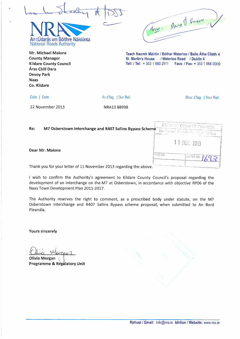


KILDARE
fl rl\ --
NATIONAL ROADS OFFICE
Mr Hugh CreeganDirector of Transport Investment and Our Ret: NRO-700(OIS)-1 0.25
taxi regulation Your Ref:National Transport AuthorityDun Scéine 30th April 2014Harcourt LaneDublin 2
Re: M7 Osberstown Interchange and R407 Sallins Bypass - MotorwayOrderICPO Application (Ref No. PLO9.MAOOI3 and PLO9.HA0046) and NTASubmission
Dear Hugh,
I refer to the above scheme and to your letter to An Bord Pleanála dated 28th
February 2014 highlighting no objection in principle to the scheme, welcoming theoverall proposal in relation to provision of facilities for cyclists and pedestrians, andsuggesting items that are addressed at the detailed design stage.
The item raised in your letter to be addressed at detailed design stage is:
- To make adequate provision for the connecting ramps from the Grand Canal CycleRoute to the Western Distributor Road.
I confirm that should the scheme receive a successful outcome from the statutoryprocess, as requested, Kildare County Council and their designers will liaise with theNational Transport Authority at detailed design stage to address, to the satisfactionof the Authority, all issues raised in your submission.
Should this be satisfactory, I would appreciate if you could reply and acknowledgethat this is acceptable to the Authority.
Yours sincerely,
/~-
“avidO .,.~
AlSenior Engineer
Direct Dial No. 045 988 908Mobile: 086 829 5322
Kildare County Council National Roads Office, Block B, Maudlins, Naas, Co.Kildare, Ireland. 0 ENGINEERSOWg Boithre NáisiUnta Comhairle Contae Chill Dara, Bloc B, An Maidilin, An Nás, Contae Chill Dara, Eire. IRELAND
Tel: +35345988900 Fax: +35345875845 Email: [email protected]

COUNCIL.‘,t;r~~l q.0,!,~ ~‘~‘sign Office j
I NáisiUnta1 4 MAY 2014 National Transport Authority
Harcourt Lane, Dublin 2tifF. LCTTER NO.
3ur SC~InE, BdIle ~dki Cl’dfl’
tel: 01 8798300fax: 01 879 8333ema : inIo@nationaltransportieweb .nanonaltransport.ie
David O’Grady,A/Senior EngineerKildare National Roads Office,Kildare County CouncilBlock B,Maudlins,Naas,Co. Kildare.
12th May 2014
Re: M7 Osberstown Interchange and R407 Sallins Bypass - Motorway Order Application (ReferenceNo. PLO9.MAOOI.3 & P109.HAOO4G).
Dear David,
I acknowledge receipt of your letter dated 30th April regarding the above matter (Your Ref: NRO-700(O/S)-1O.25).
I confirm that the arrangement set out in your letter is satisfactory to us and I look forward to liaisingwith you at the detailed design stage of the project.
Yours sincerely,
HDirector”bf Transport Investment and Taxi Regulation.
Page 1 of 1


M7 Osberstown Interchange & R407 Sallins Bypass Scheme
Main Brief
Main Brief / FINAL
Appendix B
Outline Environmental Operating Plan