Embed Size (px)
Citation preview

Gravity Study of the San Gabriel Mountains,
By
Laurence A. WoOd
Suimitted in Patial Fulfillment of the
Requirement for the Degree of Bachelor
of Science
at the
MASSACHUIETTS INSTITUTE OF TECIOLOGY
LINDGREN
June, 1968
Signature of Author . . . . .
Certified by . . . . .The si Supe-rvisor
Accepted by .........
Chairman, Departmental Comitteeon Thc3es

MITLibrariesDocument Services
Room 14-055177 Massachusetts AvenueCambridge, MA 02139Ph: 617.253.5668 Fax: 617.253.1690Email: [email protected]://libraries.mit.edu/docs
DISCLAIMER OF QUALITYDue to the condition of the original material, there are unavoidableflaws in this reproduction. We have made every effort possible toprovide you with the best copy available. If you are dissatisfied withthis product and find it unusable, please contact Document Services assoon as possible.
Thank you.
Due to the poor quality of the original document, there issome spotting or background shading in this document.

-2-
Abstract
A gravity study of the San Gabriel Mountains was made. A map of
Bouguer anomalies in the area was completed and a profile across the
mountains was taken. Calculations of the crustal thickness beneath
the Los Angeles basin, the San Gabriel Mountains, and the Eajave tesert
were made using the sin x/x method and a method described by Bott.
These calculations indicate that there is a crustal thinning under
the San Gabriel Mountains to 27 km. Values of 35 and 38 km were
obtained for the Los Angeles basin and the IMojave Desert respectively.
These results correspond quite closely to seismic determinations of
the crustal thickness in this area. They indicate that forces
originating in the mantle were important in the uplift of the San
Gabriel Mountains.

Aoknowledgement
The author wishes to express his gratitude to ProfessorrSbawn
Biebler' for his suggestion of thetpid and the data used in this
paper. His assistance throughout this project was invaluable.

Title Page.
Abstract . . . . . . .
Acknowledgement
Table of Contents
Introduction
Geologic Setting.
Geophysical Survey
Geology .;. . . ..
Rocks . . . . . .
$tructure . . . .
Gravity Anomalies
Areal Features
Profiles . . . .
Computations
-Comparisons .
Conclusions . . . . .
. .. . . . . . . . . . . . . . .. . . . p. 25
-4-
Table of Contents
.~~~ ~~ . .. . . . . . . . .
.p. 1
.'p. 2
p. -3
p. 4
p. ._5
p. 6
p. 6
p- 7
p. 8
. p. 10
p. 13
p. 14
p. 15
p. 17
p. 20
p. 23
Bibliography . . .
r
Introduction

-6-
Geologic Setting. The San Gabriel Mountains are an intri-
cately faulted block of pre-Tertiary intrusive and metamorphic rocks.
They are characterized by an extremely rough topography with many V-
shaped canyons. They are a part of the Transverse Range pfrovince of
Southern California. The axis of the range runs almost directly east-
west for sixty miles from San Bernardino to San Fernando. The maximum
width of the mountains is about twenty miles. The San Gabriel Mount-
ains are bounded by three major fault zones -- the San Andreas on the
northeast, the Sierra Madre on the south, and the Soledad on the north-
west. They are bordered by the Mojave Desert 6n the north, and Los
Angeles Basin on the south, the San Bernardino Mountains on the east,
and the Santa Susana Mountains, Santa Monica Mountains, and Sierra
Pelona on the west. They were uplifted to their present height during
Pleistocene time.
Geophysical Survey. A map of Bouguer Anomolies was compiled
from gravity readings taken in the mountains themselves, The Mojave
Desert, the Los Angeles Basin, and the Sierra Pelona. The primary
purpose of the investigation was to determine the crustal structure
beneath the San Gabriel Mountains, which have little effect on the
marked regional gravity trend in the area due to seaward thinning of
the earth's crust.
-7-
Geology

-8-
Rocks. The oldest rocks in the San Gabriel Mountains are a
series of metamorphosed sedimentary strata. Miller (1934) has desig-
nated this series as the Placerita Formation and has given them a pre-
Cambrian Age. They crop out in a very limited area near Placerita
Canyon in the southwestern part of the range, but are present as in-
clusions in the complex rocks (San Gabriel Formation) which form
much of the western section of the mountains, They are composed of
various kinds of schists, quartzites, and crystalline limestones.
Another old series of metamorphosed sediments crops out in
the eastern section of the San Gabriel Mountains. 'This has been
called the Pelona Schist and is composed of quart z-albite schist.
Miller (1934) believes this series to be younger than the Placerita
Formation (late pre-Cambrian. or earLy-Paleozoig) because it is less
metamorphosed and has not been lit-par-lit injected by granite.
Another pre-Cambrian formation present in the San Gabriel
Mountains has been designated by Miller (1934) as the San Gabriel
Formation. It is an intimate mixture of granite, metadiorite, meta-
sediments, and dikes of diorite and granodiorite. Its composition
is generally granodiorite. It crops out extensively in the western
part of the mountains.
One of the most interesting formations in this range is a
large anorthosite massif which is present in the northwest portion
of the mountains. Most of the massif is composed almost purely of
andesine, but there are also facies ranging through gabbroic anortho-
site to almost pure titaniferous magnetite. Neurerberg and Gottfried
(1954) have dated the anorthosite as 930 t 90 million years old
using lead alpha activity measurements. This confirms Miller's

-9-
belief that the Placerita and San Gabrial Formations are pre-Cambrian,
because contacts between the anorthosite and San Gabriel show the anor-
thosite to be younger. It also raises an interesting question because
a pegmatitic granite intrusion, presumably Lowe granodiorite, in the
anorthosite was dated at 810 + 80 million years. Miller did not believe
that there was any igneous activity in the area between the intrusion
of the anorthosite and Jurassic time. Miller postulated that the
massif was a thickset laccolith or batholith increasing in width
upward which shouldered its way through the San Gabriel Formation.
The massif is also interesting geophysically because there is a large
mass excess apparently associated with it.
,The only other extensively developed pre-Tertiary formation in
the western San Gabriel Mountains has been called the Lowe granodiorite
by-Miller (1934). Its most common facies is porphyritic. Miller
believes that the granodiorite is Jurassic in age, based on correlation
with similar formations in neighboring areas.
Alf (1948) describes a section at the southeagtern tip of the
San Gabriel Mountains. It includes (from youngest to oldest) -- pyroxene
dioritic gneiss, undifferentiated metamorphics composed primarily of
quartzite and crystalline limestone of probable Paleozoic age, gneiss
and mylonite, and quartz dioritic gneiss.
All of the formations described above are mapped on Plate 2.
There is no detailed description of the rocks in much of the east-central
San Gabriel Mountains. However, some extension of Miller's (1934) map
has been made into this area. The extensions are indicated as ques-
tionable.

-10-
Tertiary and Quaternary formations are present along the margins
of the San Gabriel Mountains. Some of the more significant ones will
be described. The Martinez Formation, which lies between the San
Andreas and San Jacinto Faults, is described by Noble (1954). It
consists of over 6000 'feet of marine shales, arkosic sandstone, and
conglomerate of Paleocene age. The Punchbowl Formation outcrops near
the southeastern tip of the mountains and consists of up to 8000 feet
of conglomerati sandstone with some shale and limestone. It is of
late Miocene age. The Vasquez formation (Jahns and Muehlberger, 1954)
consists of up to 12,500 feet of conglomerate, breccia, and sandstone.
It lies just north of the Saledad Fault. The Saugus Formation
(Howell, 1954) crops out south of the San Gabriel Fault near the
western tip of the mountains. It consists of over 7800 feet of arkosic
sandstone and conglomerate and is late Pliocene to early Pleistocene in
age. A thick sequence of sediments and volcanic flows crops out north
of the center of the mountains. It is over 8000 feet thick and is of
Miocene age (Miller, 1934).
Structure. The San Gabriel Mountains can be regarded as a.
gigantic horst which has been transected by countless fault and shear
zones. Several of the major faults will be considered.
The major fault in the area is the San Andreas Fault, which
runs along the hbrtheast margin of the mountains. It is essentially
vertical and movements along it have been right lateral strike slip.
It has existed since pre-Tertiary time and there are displacements of
older rocks up to a few hundred miles (abey, 1950), A movement of
thirty miles since Miocene time.-is indicated by displaced.sediments
(Noble, 1954).
-. i.
-11-
Intimately associated with the San Andreas Fault is the San
Jacinto Fault, which runs parallel to and is separated from the San
Andreas Fault by two to four miles along most of the San Gabriel
Mountains. Movements along it have also .been strike slip.
The oldest fault in the San Gabriel Mountains is the Vincent
Thrust Fault. It runs a sinuous course through some of the highest
country in the mountains, near the eastern end. It is a thrust
fault and commonly dips southeastward at angles less than 450. It
marks the contact between the Pelona schist and younger plutonic
rocks and is at least Mesozoic in age (Noble, 1954).
The San Gabriel Fault traverses the entire range in an essen-
tially east-west direction from three to eight miles north of the
mountain front. It dips steeply northward. Movements have been
left-lateral strike slip up to 2 1/2 miles in areas northwest of the
mountains (Oakeshott, 1954). It has existed since late Miocene, possib4
since Upper Eocene or Oligocene, time. It butts against the San
Jacin'to Fault.
~ The Soledad Fault runs along the northwest margin of the
mountains. It is a northerly dipping normal fault. It has not been .
active since Lower Miocene time. It butts against the San Andreas
Fault (Jahns and Muehlberger, 1954).
The southern front of the San Gabriel Mountains is defined
by the Sierra Madre Fault Zone. It is a complex-group of branching
and enechelon faults. Dips range from steeply south to moderately
north and movement has been thrust faulting (Bailey and Jahns, 1954).
Miller (1934) postulated that the San Gabriel Mountains existed
as a positive area throughout Tertiary time. By the end of Pliocene

-12-
time.the mountain area had been eroded to a.peneplain. In early
Quaternary time, the present mountain mass began to rise and
has continued to do so until the present. They are still rising
at a rate of about 20 inches per century (Noble, 1954). Strong
lateral ( north-south to northeast-southwest) pres::ure has been
an important factor in these movements (iller, 1934). Movement
in the San Andreas, 'San Gabriel and Sierra Madre fault zones has
been hisa-angle thrust falting. Miller also states that vertical
forces must have been present during this tirae.

-13-
Gravity Anomalies

--14-
Areal Features. Platell is a map of Bouguer anomalies plus
1000 milligals for the region. The contour interval is 5 milligals.
The most striking feature of the map is the regional gra-
dient which extends from the San Andreas falt zonae southwest across
the mapped area and then across the Los Angeles basin. Gravity in-:.
creases along this line, probably due to thinning of the earth's
crust.
The San Gabriel Mountains seem to have little effect on
this regional trend. Except for the extreme western portion..of .the range
contours run roughly parallel to the San Andreas fault zone. The
positive gradient across the range is steeper than the regional
gradient. The western section of the mountain is dominated by a
gravity high, centered over the anorthosite massif described
earlier.
The Mojave Desert is a region of extremely uniform gravity
in the area mapped. Except for isolated sedimentary troughs, the
gravity anomalies lie between -95 and -110 milligals over most of
this region. There is no significant regional trend, although con-
tours near the San Andreas falt tend to run parallel to it.
The gravity high associated with the anorthosite body in the
San Gabriel Mountains extends northward into the Sierra Pelona.
These mountains are composed primarily of Pelona schist. There is
a gravity low west of the San Gabriel Mountains, probably due to
the extremely thick sedimentary sequence in the Ventura Basin.
There are two areas 'mapped which have extremely large gravity
gradients. Just southwest of the western tip of the San Gabriel
Mountains there is a positive southward gradient of up to 6 milligals
per mile, due to a transition from the low associated with the

-15-
Ventura Basin to;a high which is centered near the eastern edge of
the Sayita. 1onica Mountains, where basement rocks are extensively exposed.
The second large gravity gradient is centered on the San Jacinto
fault just south of San Bernardtno.It has e positive gradient south-
westward of up to 10 milligals per mile. It lies along a contact
between Jurassic granite and Pliocene sedimentary rocks.
Profiles. Two profiles were made and are shown with their
geologic sections on Plate 3. The first extends from San Pedro across
the Los Angeles Basin and San Gabriel Mountains, to the Mojave Desert.
Its trace is shown (A-A') on Plate 1 and Figure 5. The gravity values
in the Los Angeles Basin weretaken from a paper by Mc Culloh (1960).
Figure 1 is a contour map from this paper.. It is believed possible
to -treat the anomalies on the profile as two dimensional with
limited exceptions. In the San Gabriel Mountains the profile runs
almost normal to the gravity contours which are quite uniform on
each side of it. It crosses through the center of an area of extremely
low gravity relief in the Mojave Desert. From San Pedro to the
central Los Angeles Basin the profile runs normal to the contours.
In all these areas the profile can be regarded as a good represen-
tation of a two dimensional structure. From the central Los Angeles
Basin to the southern face of the San Gabriels there is a negative
gravity gradient southeastward across the profile. The gravity values
in this section may be slightly higher than they should be in making
a two dimensional interpretation. The second profile was taken across
the gravity high present in the western San Gabriel Mountains and

-15-
34'10'
O 2
e *(
---- 4
330
255
20.0
E X PL ANAT IO N
Ix
Co*ointer'|l 5o lOglsEZ A N533*30'
118*32'30" 118*00' .117'37'30'
-- 5 10MILES
Figure 1.
Bouguec anoralies in the Los Angeles basin.

-17-
the Sierra Pelona. Its trace is shown (B-B') on Plate 1. The values
on this profile should give a valid two dimensional interpretation
with the exception of those near the southern end. In this area
there is a large positive gravity gradient eastward across the profile.
The values in this section of the profile are probably slightly too
high.
Computations. 'he gravity values alomg the profiles were
used to compute the crustal thickness beneath the profile (A-A')
by two different methods. The first was the sin x/ x method. This
method involves a calculation of the mass variation at a given depth
necessary to produce the observed gravity profile. Assuming a certain
density contrast between the crust and the mantle, it is then possible
to calculate the variations in crustal thickness along the profile.
The density contrast was assumed to be 0.3gm/cm5 . A typical profile
is shown in Figure 2. The surface along which masues were calculated
has a depth of 27 kilometers.
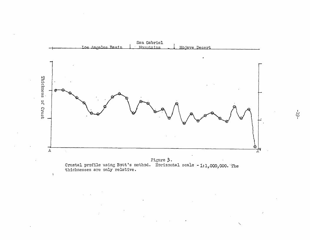
The second computation was based on a method described by
Bott (1960). It provides a picture of relative, rather than absolute,
thickness. This method involves the division of the profile into a set
of two dimensional strips. A regionally corrected gravity value for
the center point of each strip is determined and an initial estimate
of the thickness of each block is made from these values with an
assumed density contrast (0.3gm/cm3). These thicknesses are then
altered in a series of iterations until the calculated gravity effect
closely matches the observed profile. The results of this coiputation
are shown in Figure 3. Except for the two points at each end of the

San GabrielI Mouintaiins IMoive Bieeert
Figure .
Crustal profile using sin x/x method. Horizontal scale - 1:1,000'j000.
-j
C)
CD
Cl)
UH)
aH
U)10
g~n ,nPic R4-n Nn t iLos An
eles
Basin
San GabrielM - r M +unain - I ~
Figure 3.Crustal prof ile using Bott's method. Horizontal scale - 1:1,000,000. "Thethicknesses are only relative.
g , -, -P .- I ,,, ,M-% n,Tan An olan Ensin

-20-
of the profile the calculated gravity value is within one milligal
of the observed. Although the calculated thickness is very erratic,
its general structure is quite simular to that obtained by the
sin x/ x method.
Both calculations indicate that there is an anti-root
associated with the San Gabriel Mountains..The relief of this feature
is 11 kilometers. This may be slightly exaggerated due to the un-
realistically high gravity values southwest of the mountains which
were mentioned earlier. However, its existence as a feature'of
considerable magnitude seems established. The trough to the south-
west is associated with the Los Angeles Basin.
Comparisons. Figure 4 shows the results of seismic work done
by Roller and Healy (1950). Figure 5 shows a trace of their profile
and profile A-A'. Although the general crustal structure in this
figure is simular tothat calculated by the sin x/ x method, there
is a major discrepancy in the actual depths of the two models. Figure
5 shows the anti-root to have a relief of only 5 kilometers. Their
-model--also shows-the crustal thickness under the Mojave near point A'
to be 27 kilometers. This discrepancy may be partially due to hetero-
geneties in the crustal structure since this point is near the beginning
of crustal thickening associated with the San Andreas fault, but the
difference seems too' large to be wholly accounted for in this manner.
The gravity trough to the northeast of the San Gabriel Mountains has
a depth of 38 kilometers by the sin x/ x method and 37 kilometers by
the seismic method. The seismic model gives a thickness of 40 kilometers
under the Los Angeles Basin, and the gravity one gives 55 kilometers.

-21-
U 0
Mojave Desert
20 -
. -
-40
?! I
Refraction CoverageTwo Way Refraction
RelcinCoverage - Reflect onCCoverage
Coergen 100 200 300 Coverage 400
Distance (km)
Figure 4.Crustal thickness from Santa M'onica Bay to Lake Mead from 'eismic data.
122'
Figure 5.Traces of ,seismic profile and gravity profile A-A'.

-22-
Another large difference in thickness is present at the western end
of the profiles - 27 kilometers for' sin x/ x and 35 kilometers for
seismic. This difference may be partially due to seaward crustal
thinning since the gravith profile extends further west than the
seismic, but again the whole difference cannot be explained in this way.
Thus the gravity and seismic models agre. in their-general structure,
but differ in actual thickness, especially near the end points and in
the central San Gabriel Mountains. The end point differences may be
due to the method used in calculating the sin x/.x profile. The
gravity values at the end points were continued outward without change,
which in the southwest would make the calculated crustal thickness
thinner than it should be. The effect of this at the northeast end is
not clear. The two values given for the San Gabriel anti-root might
be regarded as upper and lower limits of its relief.
McCulloh (1960) postulated a thickness of 30 kilometers in
the central Los Angeles Basin. This figure appears to be seriously
in error. He also postulated that the 14ohorovicic discontinuity
slopes uniformly across the basin and flattens on either side of it.
This also appears to be incorrect.

Conclusions
-23-

The San Gabriel Mountains are a mass of pre-Cretaceous
crystalline rocks which were uplifted most receiitly by high-angle
thrust faulting initiated in early Quaternary time. The uplift is
still continuing presently. Strong lateral pressure was an important
factor in the mountain building. Gravity data indicate that vertical
forces initiated in the mantle were also important, because there is
a large upwarping of the Mohorovicic discontinuity beneath the
mountains.
One possible explanation of the cause of these mantle forces
suggests itself. The deposition of 3 kilometers of se'diment in the
Los Angeles Basin during Pliocene and Pleistocene time resulted in
displacement of a corresponding thickness of mantle material. The
San Gabriel Mountains offered an easy outlet for this material since
there was already established along its margins a well developed
fauly system. The mantle material moved under the San Gabriel
Mountains and displaced them upward. This theory is admittedly highly
.speculative, but accounts for the crustal structure beneath the
-Los -Angeles Basin and San Gabriel Mountains, and is supported by the
fact that the Soledad Fault has been inactive since Miocene time.

Bibliography
Alf, R.M., "A ylonite Belt in the Southeastern San Gabriel Mountains,
California", Geol. Soc. of America Bulletin, Vol. 59, 1948, pp.1101-1119.
Bailey, T.L. and Jahns, R.H., "Geology of the Transverse Range Province,
California", Calif. Div. of Mines Bulletin 170, Chapter 2, 1954,
pp. 83-105.
Bott, 1.H.P., "The Use of Rapid Digital Computing Methods for Direct
Gravity Interpretation of Sedimentary Basins", -Geophysical Journal,
Vol. 3, 1960, pp. 63-67.
Howell, B.F., "Geology of the Little Tujunga Area, Los Angeles County,"
Calif. Div. of Mines Bulletin 170, Map Sheet 10, 1954.
Jahns, R.H. and Mueblberger, W.R., "Geology of the Soledad Basin, Los
Angeles County", Calif. Div. of Mines Bulletin 170, Map Sheet 6, 1954.
Mabey, D.R., "Gravity Survey of the Western Mojave Desert, California",
U.S.G.S. Professional Paper 316-D, 1960, pp. 51"70.
McCulloh, T.H., "Gravity Variations and the Geology of the Los Angeles
Basin'of California", U.S.G.S. Professional P 400-B, 1960,
pp. 320-325.
Miller, W.J., "Geology of the Western San Gabriel Mountains of California",
Pub. of U.C.L.A. in Math. and Physical Scienes, Vol. 1, 1934, 83 p.
Neuerberg, G.J. and Gottfried, David, "Age Determinations of the San
Gabriel Anorthosite Massif, California," Geol. Soc. of America Bul1.,
Vol. 65, 1954, p. 465.

Noble, L.F., "San Andreas Fault Zone from Soledad Pass to Cajon Pass,
California", Calif. Div. of Mines BaLletin 170, Chapter 4, 1954,
pp. 37-50.
Oakeshott, G.B., "Geology of the Western Fan Gabriel Mountains, Los
Angeles County", Calif. Iiv. of Mines Bulletin 170, Map Sheet 9,
1954.
Roller, J.C. .and Hcaly, J.H., "Seismic Refraction Measurements of
Crustal Structure between Santa Monica Bay and Lake Mead",
Journal of Geophysical Research, Vol. 68, 1963, pp. 5837-5849.