Embed Size (px)
Citation preview
8/6/2019 Legal Feasibility Final Var
http://slidepdf.com/reader/full/legal-feasibility-final-var 1/15
DATE
A11U100 R&D STUDIO
GROUP
TUTORS
STUDENTS
21th of January 2011
Socio-Spatial Processes in the City
5A
Alexander VollebregtPeter Smit
Jenny Nauta | 1303163 | [email protected] Briet | 4031024 | [email protected] Grubic | 4118928 | [email protected] Viktorija Prilenska | 4120175 | [email protected] Kabali | 4121880 | [email protected]
_REPORT:LEGAL FEASIBILITY
8/6/2019 Legal Feasibility Final Var
http://slidepdf.com/reader/full/legal-feasibility-final-var 2/15
I_PREFACE
The second quarter of the MSc Urbanism focus-es on Socio-Spatial Processes in the City. Thecase study of R&D studio this quarter is the city
of Nijmegen. The city expands to the North,relocates the dike and widens the river, at thesame time a new ringroad is designed to con-nect new parts of the city and solve current traf-c problems. Our team has proposed an overallurban vision for the future development of thecity - ‘Intensifying the City Core’. The urban de-sign project is completed with economical andlegal feasibility studies of the design.
This report consists of a legal part and featuresone of the ve design projects for an overall ur-ban concept for Nijmegen ‘Intensifying the CityCore’: The Citadel. The project is focuses on thedesign of the Northen extension of the city of Nijmegen.
January 2011,
Jenny Nauta | 1303163
Gijs Briet | 4031024Tanja Grubic | 4118928 Viktorija Prilenska | 4120175Hema Kabali | 4121880
8/6/2019 Legal Feasibility Final Var
http://slidepdf.com/reader/full/legal-feasibility-final-var 3/15
II_INDEX
I_PREFACE
II_INDEX
1_PROJECT THE CITADEL1_1_Project Description1_2_Program1_3_Phasing and Stakeholders
2_SIGHTLINES2_1_Types of Sightlines2_2_Sightline Map
3_IMPORTANT BUILDING
PROJECTS3_1_Land use plan General3_2_Land use plan Detailed3_3_Building Projects3_4_Land use plan with Sightlines and
Building heights
4_THEME NOISE AND NATURE4_1_Noise4_2_Nature
2
3
4455
667
88910
13
141415
8/6/2019 Legal Feasibility Final Var
http://slidepdf.com/reader/full/legal-feasibility-final-var 4/15
1_PROJECT THE CITADEL
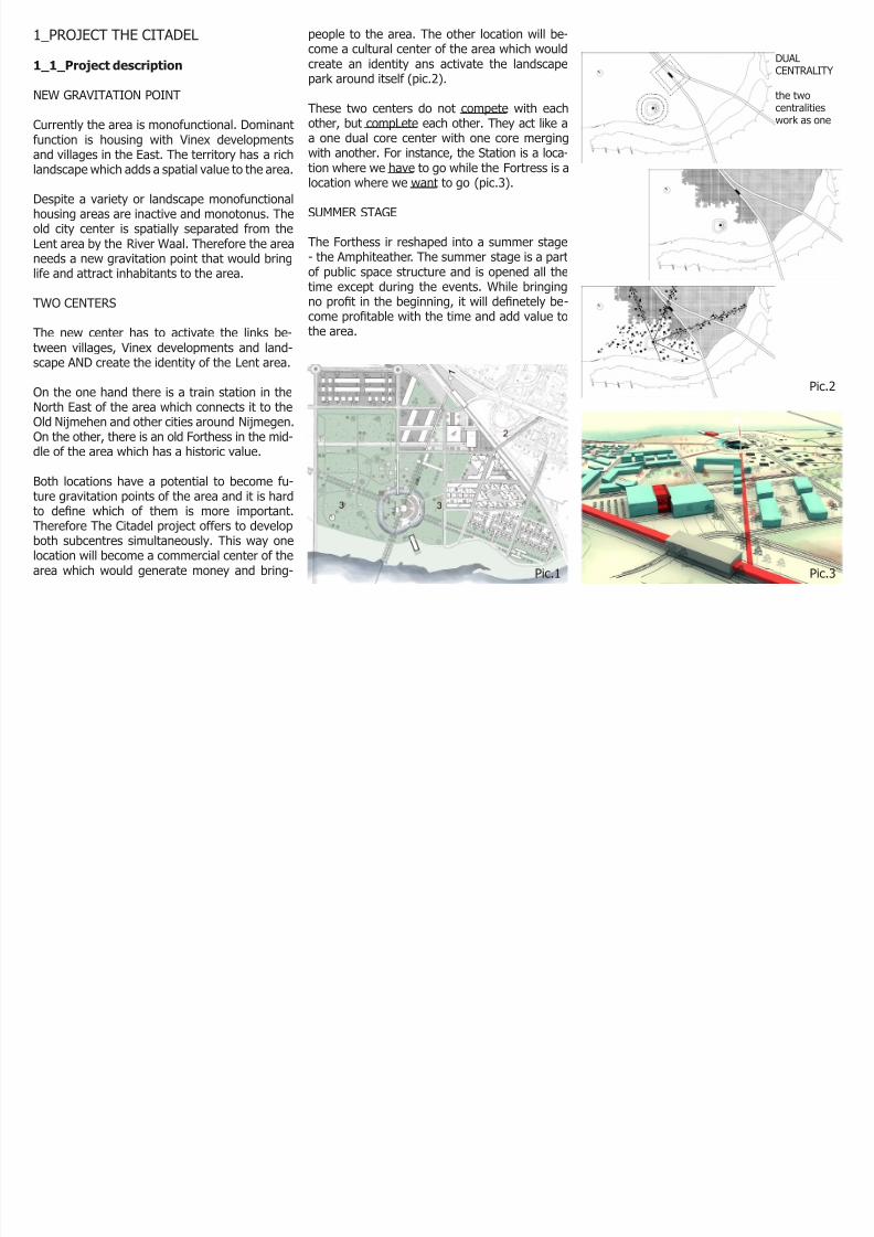
1_1_Project description
NEW GRAVITATION POINT
Currently the area is monofunctional. Dominantfunction is housing with Vinex developments
and villages in the East. The territory has a richlandscape which adds a spatial value to the area.
Despite a variety or landscape monofunctionalhousing areas are inactive and monotonus. Theold city center is spatially separated from theLent area by the River Waal. Therefore the areaneeds a new gravitation point that would bringlife and attract inhabitants to the area.
TWO CENTERS
The new center has to activate the links be-tween villages, Vinex developments and land-scape AND create the identity of the Lent area.
On the one hand there is a train station in theNorth East of the area which connects it to theOld Nijmehen and other cities around Nijmegen.On the other, there is an old Forthess in the mid-
dle of the area which has a historic value.
Both locations have a potential to become fu-ture gravitation points of the area and it is hardto dene which of them is more important.Therefore The Citadel project offers to developboth subcentres simultaneously. This way onelocation will become a commercial center of thearea which would generate money and bring-
people to the area. The other location will be-come a cultural center of the area which wouldcreate an identity ans activate the landscapepark around itself (pic.2).
These two centers do not compete with eachother, but compLete each other. They act like aa one dual core center with one core merging
with another. For instance, the Station is a loca-tion where we have to go while the Fortress is alocation where we want to go (pic.3).
SUMMER STAGE
The Forthess ir reshaped into a summer stage- the Amphiteather. The summer stage is a partof public space structure and is opened all thetime except during the events. While bringing
no prot in the beginning, it will denetely be-come protable with the time and add value tothe area.
DUALCENTRALITY
the twocentralitieswork as one
Pic.1
Pic.2
Pic.3
8/6/2019 Legal Feasibility Final Var
http://slidepdf.com/reader/full/legal-feasibility-final-var 5/15
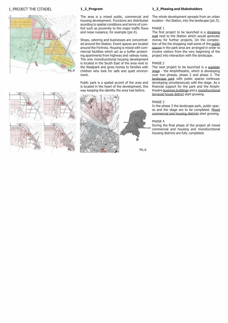
1_2_Program
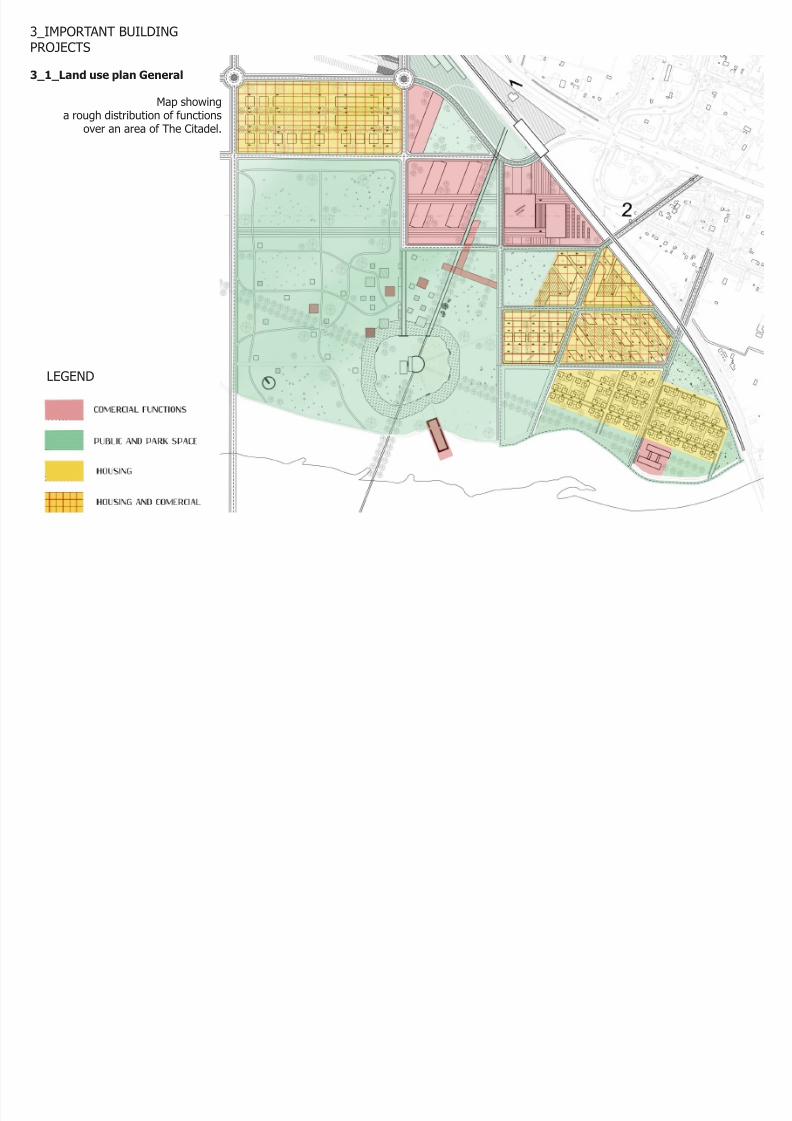
The area is a mixed public, commercial andhousing development. Functions are distributedacording to spatial conditions and terms of com-fort such as proximity to the major trafc owsand noise nuisance, for example (pic.4).
Shops, catering and businesses are concentrat-ed around the Station. Event spaces are locatedaround the Fortress. Housing is mixed with com-mercial facilities which act as a buffer protect-ing apartments from highway and railway noise.The only monofunctional housing developmentis located in the South East of the area next tothe Waalpark and gives homes to families withchildren who look for safe and quiet environ-ment.
Public park is a spatial accent of the area andis located in the heart of the development, thisway keeping the identity the area had before.
1_3_Phasing and Stakeholders
The whole development spreads from an urbanlocation - the Station, into the landscape (pic.5).
PHASE 1The rst project to be launched is a shoppingmall next to the Station which would generate
money for further projects. On the complec-tion of the the shopping mall some of the publicspaces in the park area are arranged in order toinvolve visitors from the very beginning of theproject into interaction with the landscape.
PHASE 2The next project to be launched is a summerstage - the Amphitheatre, which is developingover two phases, phase 2 and phase 3. The
landscape park with public spaces continuesdeveloping simultaneously with the stage. As anancial support for the park and the Amphi-theatre business buildings and a monofunctionalterraced house district start growing.
PHASE 3In the phase 3 the landscape park, public spac-es and the stage are to be completed. Mixedcommercial and housing districts start growing.
PHASE 4During the nal phase of the project all mixedcommercial and housing and monofunctionalhousing districts are fully completed.
1_PROJECT THE CITADEL
Pic.6Pic.5
Pic.4
8/6/2019 Legal Feasibility Final Var
http://slidepdf.com/reader/full/legal-feasibility-final-var 6/15
2_SIGHTLINES
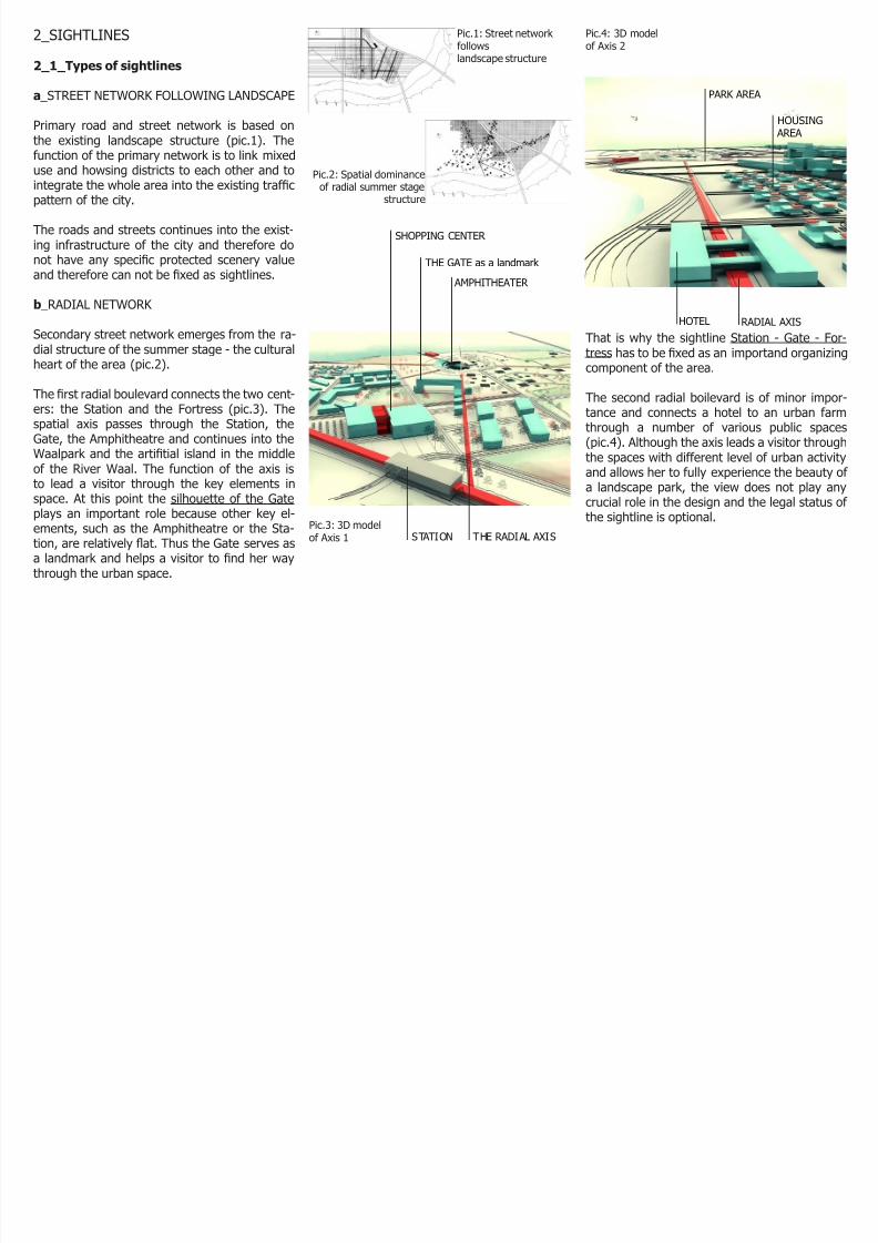
2_1_Types of sightlines
a _STREET NETWORK FOLLOWING LANDSCAPE
Primary road and street network is based onthe existing landscape structure (pic.1). The
function of the primary network is to link mixeduse and howsing districts to each other and tointegrate the whole area into the existing trafcpattern of the city.
The roads and streets continues into the exist-ing infrastructure of the city and therefore donot have any specic protected scenery valueand therefore can not be xed as sightlines.
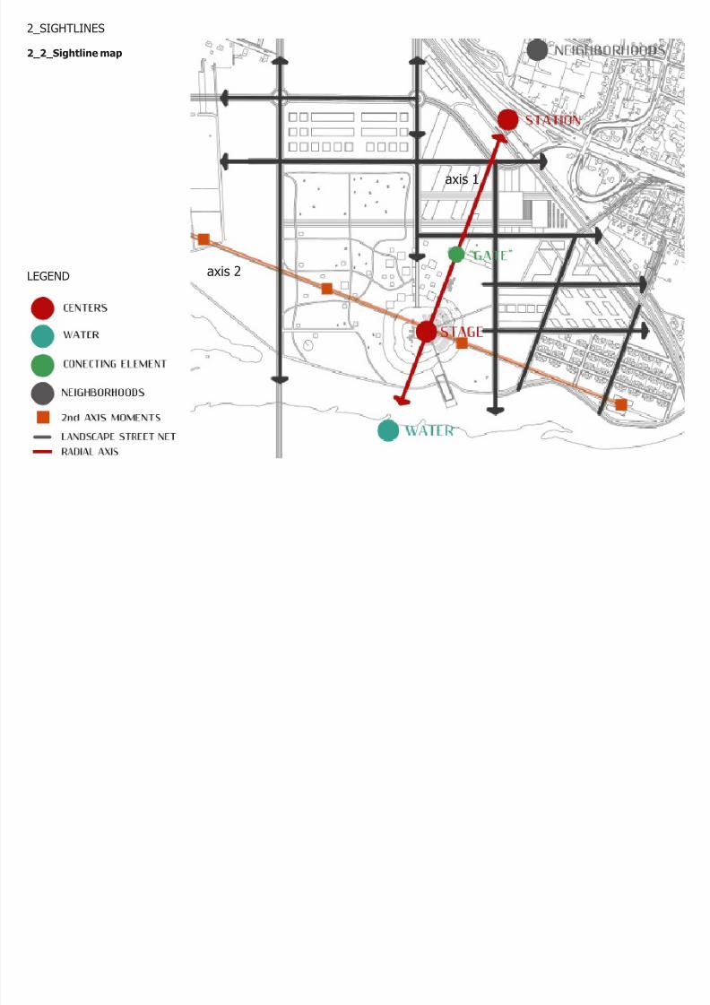
b _RADIAL NETWORK
Secondary street network emerges from the ra-dial structure of the summer stage - the culturalheart of the area (pic.2).
The rst radial boulevard connects the two cent-ers: the Station and the Fortress (pic.3). Thespatial axis passes through the Station, theGate, the Amphitheatre and continues into the
Waalpark and the artitial island in the middleof the River Waal. The function of the axis isto lead a visitor through the key elements inspace. At this point the silhouette of the Gateplays an important role because other key el-ements, such as the Amphitheatre or the Sta-tion, are relatively at. Thus the Gate serves asa landmark and helps a visitor to nd her waythrough the urban space.
That is why the sightline Station - Gate - For-tress has to be xed as an importand organizingcomponent of the area.
The second radial boilevard is of minor impor-tance and connects a hotel to an urban farmthrough a number of various public spaces(pic.4). Although the axis leads a visitor through
the spaces with different level of urban activityand allows her to fully experience the beauty of a landscape park, the view does not play anycrucial role in the design and the legal status of the sightline is optional.
Pic.1: Street network followslandscape structure
Pic.2: Spatial dominanceof radial summer stage
structure
Pic.3: 3D modelof Axis 1
Pic.4: 3D modelof Axis 2
SHOPPING CENTER
THE GATE as a landmark
AMPHITHEATER
STATION THE RADIAL AXIS
RADIAL AXISHOTEL
PARK AREA
HOUSING AREA
8/6/2019 Legal Feasibility Final Var
http://slidepdf.com/reader/full/legal-feasibility-final-var 7/15
2_SIGHTLINES
2_2_Sightline map
LEGEND axis 2
axis 1
8/6/2019 Legal Feasibility Final Var
http://slidepdf.com/reader/full/legal-feasibility-final-var 8/15
3_IMPORTANT BUILDINGPROJECTS
3_1_Land use plan General
Map showinga rough distribution of functions
over an area of The Citadel.
LEGEND
8/6/2019 Legal Feasibility Final Var
http://slidepdf.com/reader/full/legal-feasibility-final-var 9/15
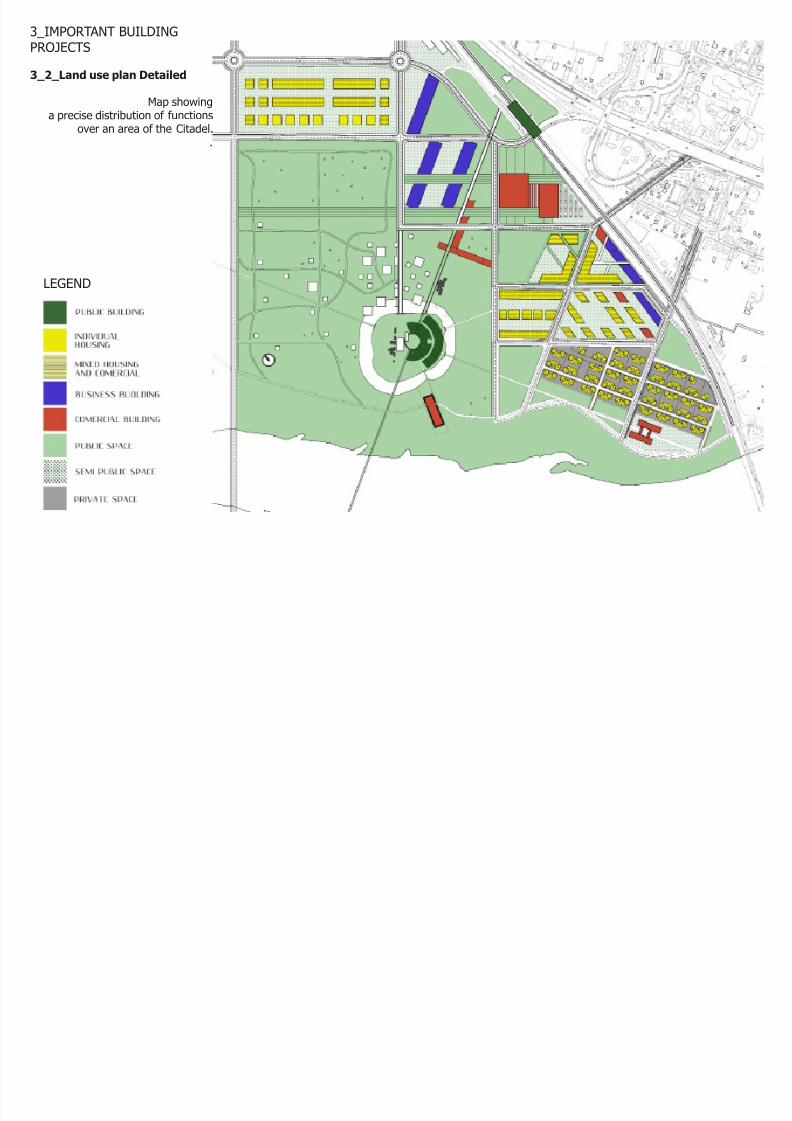
3_IMPORTANT BUILDINGPROJECTS
3_2_Land use plan Detailed
Map showinga precise distribution of functions
over an area of the Citadel.
.
LEGEND
8/6/2019 Legal Feasibility Final Var
http://slidepdf.com/reader/full/legal-feasibility-final-var 10/15
3_IMPORTANT BUILDING PROJECTS
3_3_Building Projects
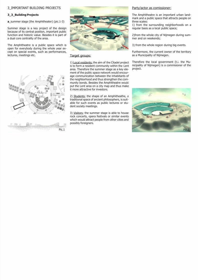
a _summer stage (the Amphitheater) (pic.1-3)
Summer stage is a key project of the designbecause of its central position, important public
function and historic value. Besides it is part of a dual core centrality of the area.
The Amphitheatre is a public space which isopen for everybody during the whole year ex-cept on special events, such as performances,lectures, meetings etc. Target groups:
1) Local residents: the aim of the Citadel projectis to form a resident community within the Lent
area. Therefore the summer stage as a key ele-ment of the public space network would encour-age communication between the inhabitants of the neighborhood and thus strengthen the com-munity bonds. Besides the Amphitheatre wouldput the Lent area on a city map and thus makeit more attractive for investors.
2) Students: the shape of an Amphitheathe, atraditional space of ancient philosophers, is suit-
able for such events as public lectures or stu-dent society meetings.
3) Visitors: the summer stage is able to houserock concerts, opera festivals or similar eventswhich would attract people from other cities andpossibly foreigners.
Party/actor as comissioner:
The Amphitheatre is an important urban land-mark and a public space that attracts people onthree scales:1) from the surrounding neighborhoods on aregular basis as a local public space;
2)from the whole city of Nijmegen during sum-mer and on weekends;
3) from the whole region during big events.
Furthermore, the current owner of the territoryas a Municipality of Nijmegen.
Therefore the local government (t.i. the Mu-nicipality of Nijmegen) is a commisioner of the
project.
Pic.1
Pic.2
Pic.3
8/6/2019 Legal Feasibility Final Var
http://slidepdf.com/reader/full/legal-feasibility-final-var 11/15
Party/actor as comissioner:
The Station is a key point in a railway network of the city of Nijmegen. The new station is locatedon the territory of the existing one; the land be-longs to the local government.
Although the Municipality of Nijmegen is a com-misioner of the project, some private investorscan be involved since the station is a moneygenerator.
Party/actor as comissioner:
The location has mixed public and commercialfunctions; the land belongs to the local govern-ment. Therefore the Gate is developed by a Pri-vate Public Partnership between the Municipalityof Nijmegen and private investors.
The ofces, if there will be any, might be par-tially rented to private companies and partiallyused for the needs of local administration.
3_IMPORTANT BUILDING PROJECTS
3_3_Building Projects
b _train station (pic.4)
The Station as a second element of a dual corecentrality is functionally dominant. It has the
highest density of an urban tissue in the areaand inuences other locations.
The station has two entrances thus allowingpeople to enter from both sides and at the sametime it can be used as shopping passage.
Target groups:are both the local inhabitants and the visitorsthat come to the area. A hotel next to the sta-
tion allows non-residents to stay in the areaover a longer period of time.
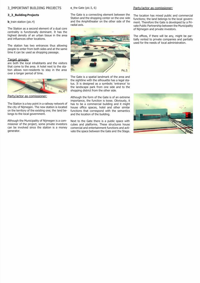
c _the Gate (pic.5, 6)
The Gate is a connecting element between theStation and the shopping center on the one sideand the Amphitheater on the other side of theradial axis.
The Gate is a spatial landmark of the area andthe sightline with the silhouette has a legal sta-tus. It is designed as a symbolic ‘entrance’ tothe landscape park from one side and to theshopping district from the other side.
Although the form of the Gate is of an extremeimportance, the function is loose. Obviously, it
has to be a commercial building and it mighthouse ofce spaces, hotel and other similarfunctions that correspond with the semanticsand the location of the building.
Next to the Gate there is a public space withcubes and platforms. These structures housecomercial and entertainment functions and acti-vate the space between the Gate and the Stage.
Pic.4
Pic.5
Pic.6
8/6/2019 Legal Feasibility Final Var
http://slidepdf.com/reader/full/legal-feasibility-final-var 12/15
3_IMPORTANT BUILDING PROJECTS
3_3_Building Projects
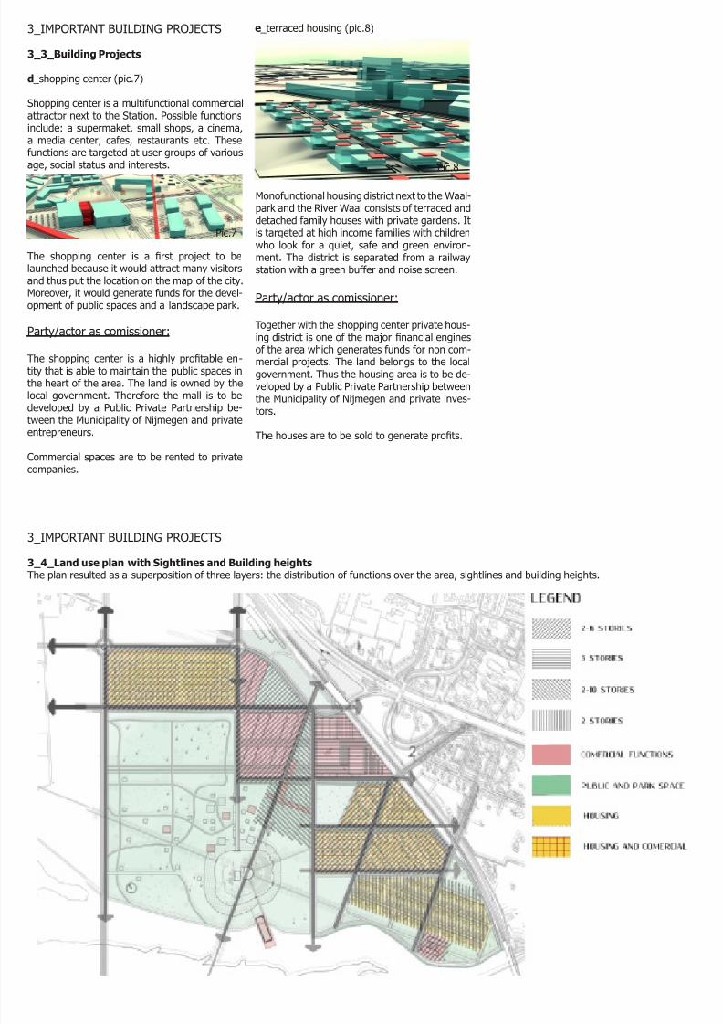
d _shopping center (pic.7)
Shopping center is a multifunctional commercialattractor next to the Station. Possible functions
include: a supermaket, small shops, a cinema,a media center, cafes, restaurants etc. Thesefunctions are targeted at user groups of variousage, social status and interests.
e _terraced housing (pic.8)
The shopping center is a rst project to belaunched because it would attract many visitorsand thus put the location on the map of the city.Moreover, it would generate funds for the devel-opment of public spaces and a landscape park.
Party/actor as comissioner:
The shopping center is a highly protable en-tity that is able to maintain the public spaces in
the heart of the area. The land is owned by thelocal government. Therefore the mall is to bedeveloped by a Public Private Partnership be-tween the Municipality of Nijmegen and privateentrepreneurs.
Commercial spaces are to be rented to privatecompanies.
Monofunctional housing district next to the Waal-park and the River Waal consists of terraced anddetached family houses with private gardens. Itis targeted at high income families with childrenwho look for a quiet, safe and green environ-
ment. The district is separated from a railwaystation with a green buffer and noise screen.
Party/actor as comissioner:
Together with the shopping center private hous-ing district is one of the major nancial enginesof the area which generates funds for non com-mercial projects. The land belongs to the localgovernment. Thus the housing area is to be de-veloped by a Public Private Partnership betweenthe Municipality of Nijmegen and private inves-tors.
The houses are to be sold to generate prots.
Pic.7
Pic.8
8/6/2019 Legal Feasibility Final Var
http://slidepdf.com/reader/full/legal-feasibility-final-var 13/15
3_IMPORTANT BUILDING PROJECTS
3_4_Land use plan with Sightlines and Building heightsThe plan resulted as a superposition of three layers: the distribution of functions over the area, sightlines and building heights.
8/6/2019 Legal Feasibility Final Var
http://slidepdf.com/reader/full/legal-feasibility-final-var 14/15
4_THEME NOISE AND NATURE
4_1_Noise
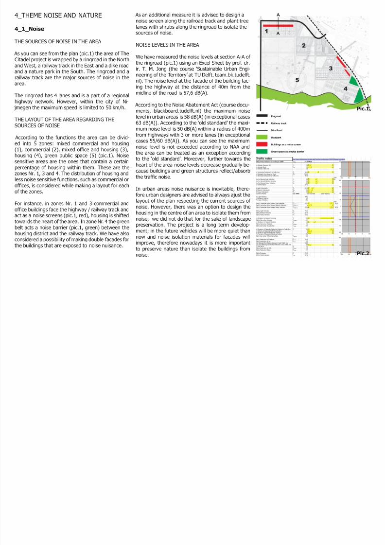
THE SOURCES OF NOISE IN THE AREA
As you can see from the plan (pic.1) the area of TheCitadel project is wrapped by a ringroad in the North
and West, a railway track in the East and a dike roadand a nature park in the South. The ringroad and arailway track are the major sources of noise in thearea.
The ringroad has 4 lanes and is a part of a regionalhighway network. However, within the city of Ni-
jmegen the maximum speed is limited to 50 km/h.
THE LAYOUT OF THE AREA REGARDING THESOURCES OF NOISE
According to the functions the area can be divid-ed into 5 zones: mixed commercial and housing(1), commercial (2), mixed ofce and housing (3),housing (4), green public space (5) (pic.1). Noisesensitive areas are the ones that contain a certainpercentage of housing within them. These are thezones Nr. 1, 3 and 4. The distribution of housing andless noise sensitive functions, such as commercial orofces, is considered while making a layout for eachof the zones.
For instance, in zones Nr. 1 and 3 commercial andofce buildings face the highway / railway track andact as a noise screens (pic.1, red), housing is shiftedtowards the heart of the area. In zone Nr. 4 the greenbelt acts a noise barrier (pic.1, green) between thehousing district and the railway track. We have alsoconsidered a possibility of making double facades forthe buildings that are exposed to noise nuisance.
As an additional measure it is advised to design anoise screen along the railroad track and plant treelanes with shrubs along the ringroad to isolate thesources of noise.
NOISE LEVELS IN THE AREA
We have measured the noise levels at section A-A of the ringroad (pic.1) using an Excel Sheet by prof. dr.
ir. T. M. Jong (the course ‘Sustainable Urban Engi-neering of the Territory’ at TU Delft, team.bk.tudelft.nl). The noise level at the facade of the building fac-ing the highway at the distance of 40m from themidline of the road is 57,6 dB(A).
According to the Noise Abatement Act (course docu-ments, blackboard.tudelft.nl) the maximum noiselevel in urban areas is 58 dB(A) (in exceptional cases63 dB(A)). According to the ‘old standard’ the maxi-mum noise level is 50 dB(A) within a radius of 400m
from highways with 3 or more lanes (in exceptionalcases 55/60 dB(A)). As you can see the maximumnoise level is not exceeded according to NAA andthe area can be treated as an exception accordingto the ‘old standard’. Moreover, further towards theheart of the area noise levels decrease gradually be-cause buildings and green structures reect/absorbthe trafc noise.
In urban areas noise nuisance is inevitable, there-fore urban designers are advised to always ajust the
layout of the plan respecting the current sources of noise. However, there was an option to design thehousing in the centre of an area to isolate them fromnoise, we did not do that for the sake of landscapepreservation. The project is a long term develop-ment; in the future vehicles will be more quiet thannow and noise isolation materials for facades willimprove, therefore nowadays it is more importantto preserve nature than isolate the buildings fromnoise.
Pic.1
Pic.2

8/6/2019 Legal Feasibility Final Var
http://slidepdf.com/reader/full/legal-feasibility-final-var 15/15
4_THEME NOISE AND NATURE
4_2_Nature
CURRENT STATE OF THE AREA
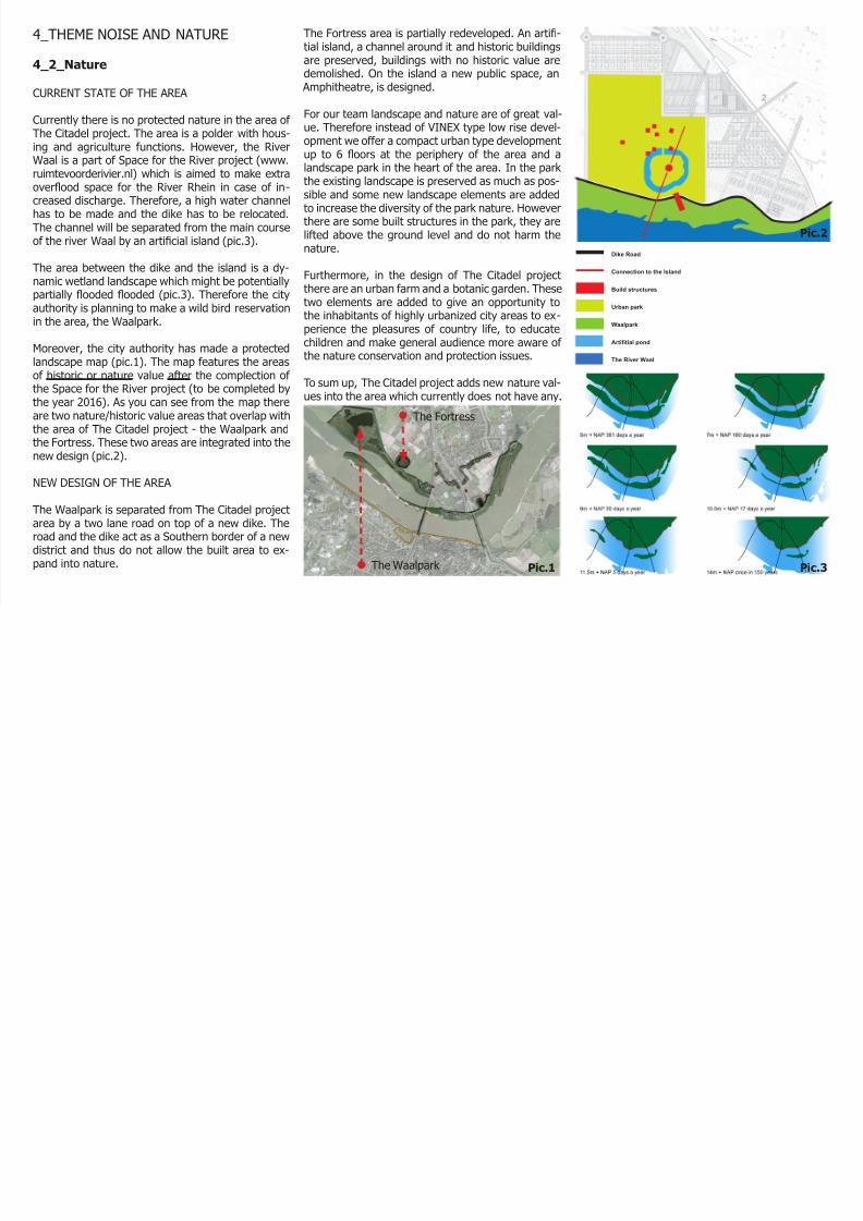
Currently there is no protected nature in the area of The Citadel project. The area is a polder with hous-
ing and agriculture functions. However, the RiverWaal is a part of Space for the River project (www.ruimtevoorderivier.nl) which is aimed to make extraoverood space for the River Rhein in case of in-creased discharge. Therefore, a high water channelhas to be made and the dike has to be relocated.The channel will be separated from the main courseof the river Waal by an articial island (pic.3).
The area between the dike and the island is a dy-namic wetland landscape which might be potentiallypartially ooded ooded (pic.3). Therefore the cityauthority is planning to make a wild bird reservationin the area, the Waalpark.
Moreover, the city authority has made a protectedlandscape map (pic.1). The map features the areasof historic or nature value after the complection of the Space for the River project (to be completed bythe year 2016). As you can see from the map thereare two nature/historic value areas that overlap withthe area of The Citadel project - the Waalpark andthe Fortress. These two areas are integrated into the
new design (pic.2).
NEW DESIGN OF THE AREA
The Waalpark is separated from The Citadel projectarea by a two lane road on top of a new dike. Theroad and the dike act as a Southern border of a newdistrict and thus do not allow the built area to ex-pand into nature.
Pic.1 Pic.3
Pic.2
The Fortress area is partially redeveloped. An arti-tial island, a channel around it and historic buildingsare preserved, buildings with no historic value aredemolished. On the island a new public space, an
Amphitheatre, is designed.
For our team landscape and nature are of great val-ue. Therefore instead of VINEX type low rise devel-opment we offer a compact urban type development
up to 6 oors at the periphery of the area and alandscape park in the heart of the area. In the park the existing landscape is preserved as much as pos-sible and some new landscape elements are addedto increase the diversity of the park nature. Howeverthere are some built structures in the park, they arelifted above the ground level and do not harm thenature.
Furthermore, in the design of The Citadel projectthere are an urban farm and a botanic garden. These
two elements are added to give an opportunity tothe inhabitants of highly urbanized city areas to ex-perience the pleasures of country life, to educatechildren and make general audience more aware of the nature conservation and protection issues.
To sum up, The Citadel project adds new nature val-ues into the area which currently does not have any.
The Fortress
The Waalpark


![Welcome [tc18.tableau.com] · 2020. 1. 6. · var css_pp = pd.css(data); var css_min = pd.cssmin(data [, true]); var sql_pp = pd.sql(data); var sql_min = pd.sqlmin(data); Click to](https://img.pdfslide.us/doc/110x75/603a266b2957ea033f3cea48/welcome-tc18-2020-1-6-var-csspp-pdcssdata-var-cssmin-pdcssmindata.jpg)
![MLRG: Basic Monte Carlo Methods - cs.ubc.ca · Var( ) = E[Var( jY)] + Var(E[ jY]) =)Var( ) Var(E[ jY]) If E[ ] is the quantity we wish to approximate, then we can use E[ jY] instead](https://img.pdfslide.us/doc/110x75/5f3ec4f2b30bfe38ed1927ea/mlrg-basic-monte-carlo-methods-csubcca-var-evar-jy-vare-jy-var.jpg)
![VOLUME 2: TRAFFIC STUDIES & ECONOMIC FEASIBILITY …...feasibility study for one detailed engineering design and legal framework for operation of one mchinji [malawi]/mwami [zambia](https://img.pdfslide.us/doc/110x75/5e9745402a3aa179c01e9848/volume-2-traffic-studies-economic-feasibility-feasibility-study-for-one.jpg)