Embed Size (px)
Citation preview

Land Use/Land Cover Classification Based on
Multi-resolution Remote Sensing Data
Yuechen Liu1, Zhiyuan Pei
1, Quan Wu
1, Lin Guo
1, Hu Zhao
1, Xiwei Chen
1
(1.Chinese Academy of Agricultural Engineering, Beijing 100125, China)
Abstract: The paper summarized pre-existing research works relating to land
use/land cover classification based on multi-resolution remote sensing data.
According to the features of regions, we carried out of the land use/land cover
classification of level Ⅲ classes in 148 group of Xinjiang agricultural
reclamation eighth division. The land use/land cover classification system
divided land in study area into 6 level Ⅰ classes, 16 level Ⅱ classes, and 22
level Ⅲ classes with multi-spatial-resolution remote sensing data. Thus we set
up a set of land use/ land cover remote sensing classification and corresponding
code system.
Key words: remote sensing classification, land use/land cover, classification
system, code system
1 Introduction
The land resource is playing an important role in production development for both
nation and region. The reasonable development and protection of land resource have
became key issue for human to explore. The accuracy and timely update of land
use/land cover classification are be of great significance to global change,
environmental monitoring, yield estimation et al. Monitoring land use / land cover via
Funding project : Technology support for sub-topics of "The 11th Five-Year plan"
(2007BAH12B04-02)
The Author : Yuechen Liu(1983—), male, assistant engineer, member of Chinese Commission
of Agricultural Engineering, the practice of land use and agricultural remote sensing. The
Chinese Academy of Agricultural Engineering, MaiZidian street 41 , Chaoyang District,
Beijing, 100125,China. Email: [email protected]
※Corresponding author: Zhiyuan Pei(1968-), male, professor, member of Chinese
Commission of Agricultural Engineering, the practice of application and research on
agricultural remote sensing. The Chinese Academy of Agricultural Engineering, MaiZidian
street 41 , Chaoyang District, Beijing, 100125,China. Email: [email protected]
remote sensing imagery has the advantage of macroscopic, fast, real-time,
characteristics and so on, specially over a large area. Using remote sensing data to
obtain and update information may be more effective and accurate. Using single
remote sensing data source to carry on the land use/land cover classification has some
limitations, such as the existence accuracy is low, versatility not strong, and so on.
With rapidly development of the remote sensing techniques, various kinds of remote
sensing datasets appears one after another, which used in land resource investigation
with different spatial scale. This research employs the different remote sensing data
imagery as a foundation, induces thedomestic and foreign projects and researches,
related to land use/land cover classification with remote sensing solution. According
to the region features, we carried out of the land use/land cover classification and the
code system in Xinjiang agricultural reclamation eighth division, for satisfying the
need of project research and instruct the area agricultural production.
2 Overview of Land use/land cover classification with remote
sensing
Using remote sensing data for establishing land use/land cover classification system
is development tendency. Low spatial resolution data has the short visit cycle and has
big coverage area. Low spatial resolution data is suited to big scale research of land
use/land cover, such as region, intercontinental, country and so on. However, lower
spatial resolution will cause the mixed pixel and be difficult to divide features of land.
Medium-resolution data were more applied to establish land use/land cover
classification, which satisfy the request of database and service structure. Along with
the high spatial resolution data being applied, the accuracy of discretion about land
types is enhancing greatly. But it has some defects, such as long visit cycle and taking
massive storage space. High spatial resolution data was more used in accuracy test
and training of supervises classifies in present projects and researches.
2.1 Land use/land cover classification based on high spatial resolution [1]~[3]
On the high spatial resolution image, the spatial information is richer and it could
reflect size, shape of the terrain features and its relations more definitely. It has been
already to launch many researches in land use/land cover change with high spatial
resolution image. Land classification item in―golden land‖ project, completed by
Sichuan remote sensing center of China, which divided all land types in the study area
to be 3 kinds of Ⅰclass land type, 9 kinds of Ⅱclass land type and 21 kinds of Ⅲ
class land type. Land use investigation in the LongWan power station finished by
Central South University of Forestry and Technology, which divided all land types in
the study area to be 3 kinds of Ⅰ class land type, 9 kinds of Ⅱ class land type and 35
kinds of Ⅲ class land type. The project of land investigation of urban land use
application in Tanggu district, Tianjin of China, which divided all land types in the
study area to be 3 kinds of Ⅰclass land type, 8 kinds of Ⅱclass land type and 23
kinds of Ⅲ class land type.
The land classification in the three projects were used QuickBird data and based on
"the Nation Land classification (Implementation)" issued by Ministry of Land and
Resources of China. In general, the framework of the three classification system is
basically the same, have adopted three-level classification. Regarding the division of
water body, three projects carried on were according to its different purposes of use.
They all have division of water body in their Ⅲ class land type, corresponding to
agricultural land, construction land and unused land inⅠclass land type. In addition,
compared with the other two projects, the classification system was more targeted and
its coverage types were more comprehensive generated by the project of land
investigation in Tanggu district. For example, the division is more detailed for
residential land and Independent mining land in its Ⅲ class land type. Urban land was
split into towns and cities in the Ⅲ class land type, moreover, added salt pans and
special land in it.
2.2 Land use/land cover classification based on medium spatial resolution [4]~[8]
At present, medium-resolution data is applied more universal on national scale study
of land use. Chinese Academy of Sciences made a land resource classification system
based on TM image with the resolution of 30 m, and utilized Spot image with the
resolution of 20 m to interpret key areas. It divided all land types in the study area to
be 6 kinds of Ⅱ class land type, 25 kinds of Ⅱ class land type. Forest land in the
Ⅱ class land type was further divided to 3 types, such as needle forest land,
broad-leaf forest land, conifer and broadleaf mixed forest, which were all included in
the Ⅲ class land type. In this project, Garden and forest land, mining, transportation
and other types of land were merged appropriately, which enhanced operability of
remote sensing classification in the Ⅰ level class land type. According to the level
of land use/land cover and integrating status of land use investigation, it obtained the
land use/land cover types of class Ⅱ.
In the project, ―HuangHuaihai agricultural land variation remote sensing
investigation for ten years‖, the Chinese Academy of Agricultural Engineering
combining with sample investigation and TM multi-spectrum data, divided land of 7
provinces in HuangHuaihai area to 6 kinds of Ⅰ level class land type and 16 kinds
of Ⅱ class land type.
National Land Cover Data,NLCD established by America, which divided all land
types in the study area to be 9 kinds of Ⅰclass land type, 37 kind of Ⅱ class land
type. The Ⅲ and Ⅳ class land types could get basing on the class Ⅱ for
requirements. Land types of classⅠ were extracted from TM images with the
resolution of 30 m. From Ⅱ to Ⅳ class land types, the land types were obtained
from Aerial Images with different height of photography.
2.3 Land use/land cover classification based on low spatial resolution [9]~[20]
Global Vegetation Monitoring Unit made use of SPOT/VGT data to execute the

theme of Global Land Cover2000. Its classification system was finished combining
with classification software of FAO/UNEP-Land Cover Classification System and a
classification system basing on data with the resolution of 1 km of International
Geosphere-Biosphere Program (IGBP). In this project, land type was divided to 22
kinds on a global scale. The IGBP combining unsupervised classification and NDVI
data of 12 months of a year divided the type of land use/land cover for 17 kinds on a
global scale. However, the versatility of the classification system is not strong for it
applying only to NOAA-AVHRR data. University of Maryland, using supervised
classification, NDVI and the 41 time series images, generated by the 5 channels of
NOAA-AVHRR, to produce a global 1km land cover product. Its category types is
basically same as IGBP’ s, when it got rid of the wetland, farmland / natural
vegetation mixed, snow and ice covered the three types.
2.4 Land use/land cover classification based on multi spatial resolution
Land use/land cover (LULC) based on remote sensing data was a Land use/land
cover classification based on multi-resolution, which generated by U.S. Department
of Interior Geological Survey(USGS)in 1976. The classification system is divided
into four. The Ⅰ level class was divided with LandSat data; for the division, the data
obtained at 12400m altitude or more, or less than 1:80000 scale;Ⅲ level class to got
data at the orbital altitude 3100~12400m, at 1:20000 scale~1:80000; Ⅳ level class
to got data at 3100m orbital altitude or less, or more than 1∶20000 scale. This
classification system included 9 kinds of Ⅰ level class land type, 35 kinds of Ⅱ
level class land type and the Ⅲ, Ⅳ level class can be expanded flexibly, combining
with airborne remote sensing data and ground survey and other data. [21]
Comparing to Anderson land classification system, it’s more suitable for remote
sensing data. The smallest unit of land cover was divided depending on the mapping
scale and resolution of remote sensing data and so on. The classifications ofⅠand Ⅱ
level class adapt to some researches of global or continental, while the classifications
ofⅠand Ⅱ level class are suitable to some researches of regional or country wide and
so on. At the same time, the system followed many features of the Anderson land
classification. Such as, the first, its types named simple and easy to be accepted and
used; the second, classified information can be converted or accessed any time; the
third, categories can be refined downward or integrated upward. However, it took into
account both land use and natural ecological background of land inⅠlevel class of
Anderson land classification system, which made the relationship between categories
is too complex to distinction. For example, some types were divided according to the
situation of land use, such as 1 - urban or building land, 2 - agricultural land, 4 - forest
land and so on. While 3 - Mountain, 6 – wetlands and 8 – tundra,which were
divided according to ecological background of land resources. [22-24]
3 The land use/land cover classification in study area
There are some respective flaws, existing in variety of classification systems. On the
one hand, the boundaries between the two categories were not clear, so that does not
apply to land cover mapping; on the other hand, the formulation of classification
system is not conducive to monitoring land cover change [25]. Responding to the
above problems, the study develops a more realistic and clear classification system
based on existing experience and achievements.
3.1 The overview of study area
Xinjiang agricultural reclamation eighth division located at Tianshan north foothill
center-section, south Songorine Basin, which is the counterpart of (Longitude):
84°58′-86°24′ / (Latitude): 43°26′-45°20′. This area is a typical temperate continental
climate; it has distinct arid and semi-arid characteristics for its annual rainfall of
180-270 mm and annual evaporation is 1000-1500 mm. There are 334200 ha of
agricultural land including 197400 ha of arable land, 2600 ha of garden land, 27100
ha of forest land, 73900 ha of grassland and 26600 ha of construction land and so on.
148 group of Xinjiang agricultural reclamation eighth division is located 80
kilometers west of the city of Shihezi city, which is an important production base of
Xinjiang agricultural reclamation eighth division. The148 group is a large
state-owned enterprise, dominated by agriculture, while combining with agriculture,
forestry, animal husbandry and industry. In this group, cotton, wheat, corn, sugar beet,
soybean etc were main agricultural planting. There are less land can be used in the
study area, affected by drought, desertification and salinization. Low efficiency of
land use, situation of the land use is incompatible with the characteristics of land
resources, which is leading to poor performance of land use structure. Soil organic
matter content is low and the heavy is low, however, it requires massive investment in
the land development and utilization. The land use types with a vertical distribution of
zonal,affected by topography and climate.
3.2 Land use/land cover classification system in study area
3.2.1 The bases and principles of land use/land cover classification
By comparing and analyzing domestic and foreign classification systems and
according to the characteristic of multi-resolution, multi-time phase remote sensing
data and features of district, we build the classification system for Xinjiang
agricultural reclamation eighth division. The system mainly reflected the following
principles: the first, the land type division need reflect consistency or similarity of
land use/land cover and natural condition, as well the primary and secondary of Land
utilization manner; the second, it is advantageous to the natural resource reasonable
use and the protection(for example, Haloxylon, Tamarix and other vegetation with
sand-fixing role should be divided into the type of shrub land rather than grass land,
even if where has been grown many kinds of thick herbaceous plants below it.); the
third, it is necessary to give attention to the types with special significance(for
example, vegetation that has the great economic value and the species gene bank
function; Special industrial crop and orchard, and so on ).
3.2.2 Land use/land cover type division
For meeting the requirements of desertification monitoring, sparse scrub and sparse
grassland were distinguished from high canopy density of the bush and high coverage
grassland by Wang Liwen. And she partitioned the land of Xinjiang into 14 kinds of
type. [26]Liu Aixia who divided the land in Shihezi to be 6 kinds of land use type,
including planter land for wheat, planter land for cotton, alkaline land, sand and
residential land, water area, irrigable land. The classification system was built based
on CBERS-1 image data, and full accounted of the local real condition, such as there
are large area of sand and alkaline land and less area of forest land and grass land in
the study area; and most of the remaining land is cultivated. [27] Moreover, carries on
the classification through the regionalization method regarding the vegetation scarce
area, may reduce the influences regarding the precision of land use/land cover
classification to a certain extent, because of the local climate, the terrain, the soil and
so on is created regarding the land utilization/cover classification precision. Space
position knowledge of ground features is benefit to raise classified precision. For
example, there are no other types except farmland, water body, garden and forest land,
residential land etc; small area bare land will be used by people, distributing around
towns; sand with small area can turn other land type through the government and so
on. [28]
We divided the land types of land use/land cover and built a classification system
with three levels, referring to "Land utilization Present situation Investigation
Technical Schedule", "The Nation Land classification (Implementation)", ―Remote
Sensing Investigation Technology and Method for Medium and Small scale land use
change‖, etc. It is a comprehensive kind of system, which collect land utilization and
the cover in a body to instruct agricultural production and agricultural resource
management.
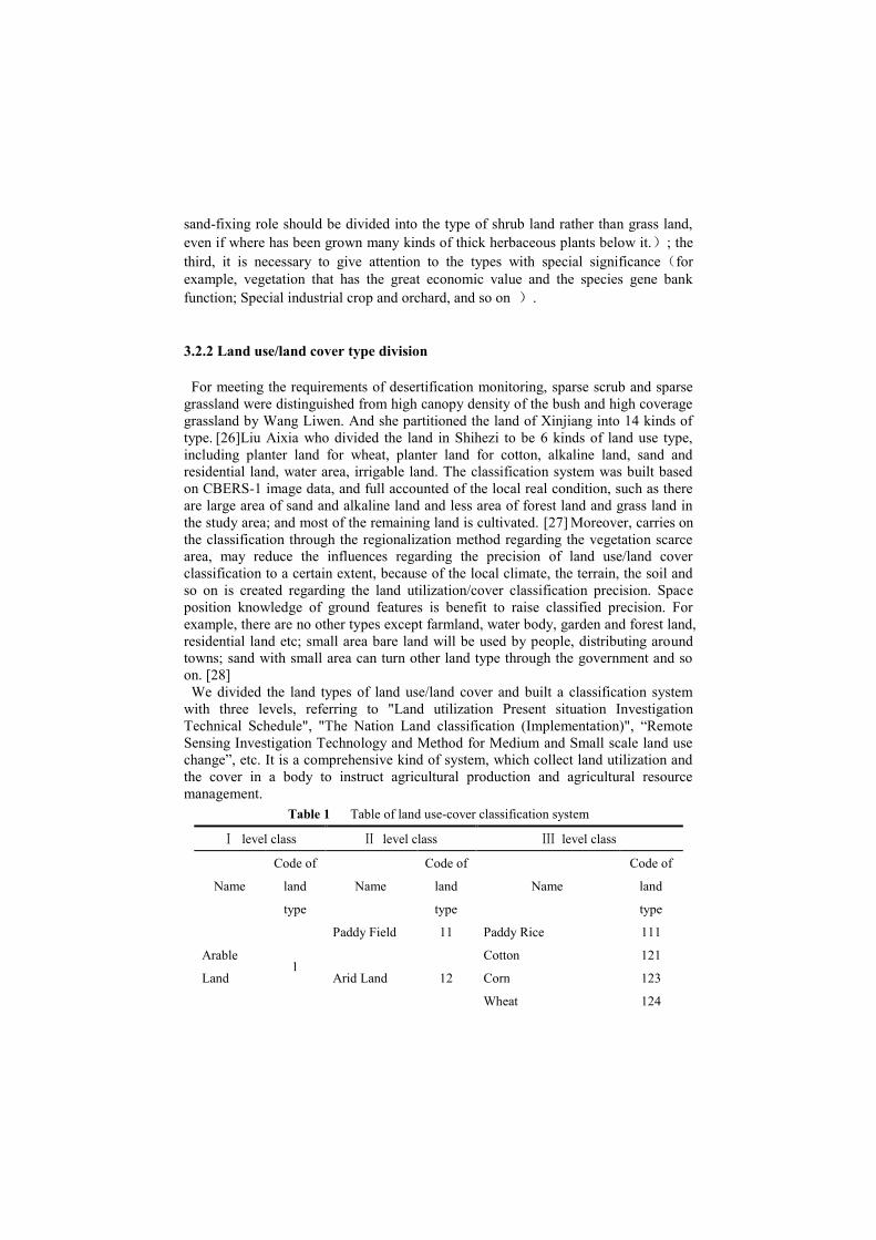
Table 1 Table of land use-cover classification system
Ⅰ level class Ⅱ level class Ⅲ level class
Name
Code of
land
type
Name
Code of
land
type
Name
Code of
land
type
Arable
Land 1
Paddy Field 11 Paddy Rice 111
Arid Land 12
Cotton 121
Corn 123
Wheat 124
Tomato 125
Other Crops 126
Leisure Land 13 Leisure Land 131
Garden
and
Forest
Land
2
Forest Land 21
Forest Land 211
Stocked Land and
Shrub Land 212
Garden Land 22
Vineyard 221
Land for Peach 222
Other Fields 223
Constructi
ve
Land
3
Residential,
Industry and
Mining Land
31
Residential Land 311
Industry and Mining
Land 312
Transportatio
n
Land
32 Transportation Land 321
Water
Body 4
Water
Surface 41
Drainage and Ditch 411
River, Lake, Basin,
Pond 412
Shallow Seas
and Tidelands 42
Snow Cover 43
Grass
Land 5
Natural
Meadow 51
Grass Land 511
Wild Grass Ground 512
Artificial
Pasture 52 Artificial Pasture 521
Bare
Land 6
Bare Field 61 Alkaline Land 611
Other Naked Land 612
Sand 62
Bare Rock 63
Gobi Desert 64

3.2.3 Analysis and application of the land use / land cover classification system
3.2.3.1 The analysis
The Ⅰ level class division By the land cover concept to describe natural quality of
biological cover types on land surface. Dividing the Ⅰ level class into 6 kinds of type,
from the aspect of cover, such as the arable land, the garden and forest land, the
constructive land, the water body, the grass land, the bare land, which combine with
multi-time phase and low spatial resolution data, in order to reflect the land cover
state in study area.
The Ⅱ level class division Considered the feasibility of remote sensing technique,
the interpretation accuracy, the type of land use and the degree of utilization, merged
or increased the land type of Ⅱ level class in former classification systems. The new
system was divided into 16 kinds of type. (1)Increase the fallow land. Fallow land is
frequent and it is defined that stop the cultivation more than one year of the land.
Fallow land can be extracted by superposition of different time phase data. (2)
Differentiates the field and the forest land. It is easily to pick-up types of the garden
land and the forest land from remote sensing image, according to the local planter
pattern and certain space position knowledge. (3)The combination of the rivers, the
lake, the basin and the pond, may strengthen the feasibility about technical processing,
simultaneously also satisfies the actual need in agricultural production. (4)Distinguish
the artificial pasture and the natural pasture. The animal husbandry was one of
important industrial, so artificial pasture is becoming a more necessary land type in
the study area. The artificial pasture is neater, can satisfied the accurate request of
extraction.
The Ⅲ level class division Taken 148 groups as the key research region and
considered that land type's use process since long, the agriculture resource protection
and the planter management's need, detail classified the types of Ⅲ level class by
high resolution remote sensing data into 22 kinds. In the sub-category of the garden
land and the forest land, which were all based emphasizing respective function. That
is to emphasize its products, application and so on.
3.2.3.1 The application
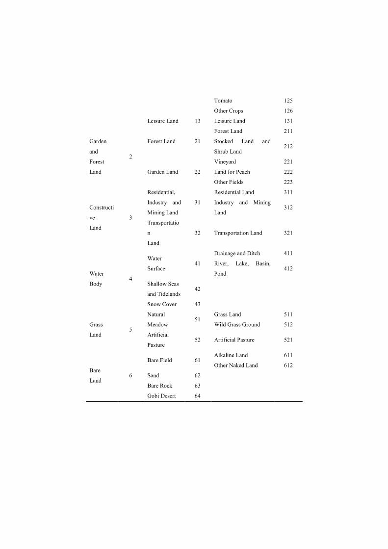
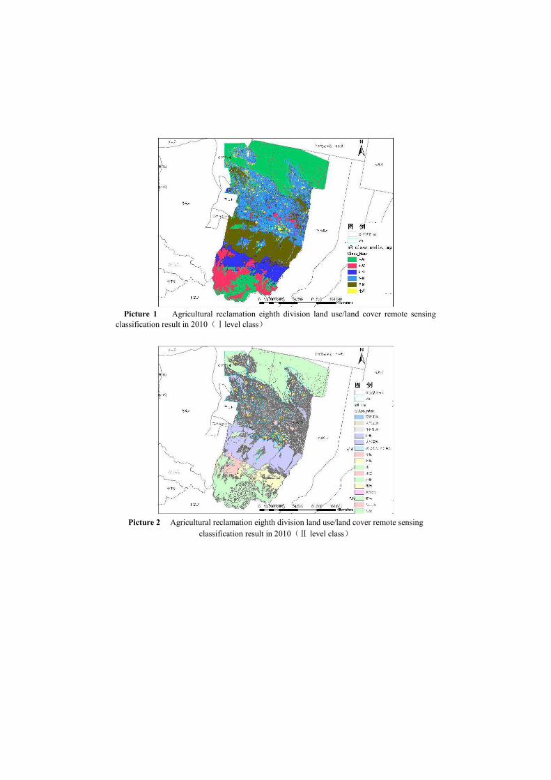
Taking the new land use/land cover classification as a foundation, carry on the Ⅰ
and Ⅱ level classes division to agricultural reclamation eighth division of Xinjiang
and the Ⅲ level class division to 148 group of Xinjiang agricultural reclamation
eighth division. Namely, take NDVI time series of MODIS separately as the classified
characteristic to various terrain features category degree of membership function for
gaining theⅠlevel classification result; According to the different classified object
and choosing the decision tree construction method which based on knowledge and
samples, as well as the man-machine interactive way, gain the Ⅱ level classification
result with TM data; gain the Ⅲ level classification result with Rapideye data.
(Classified result as shown in picture 1, picture 2 and picture 3)
Picture 1 Agricultural reclamation eighth division land use/land cover remote sensing
classification result in 2010(Ⅰlevel class)
Picture 2 Agricultural reclamation eighth division land use/land cover remote sensing
classification result in 2010(Ⅱ level class)
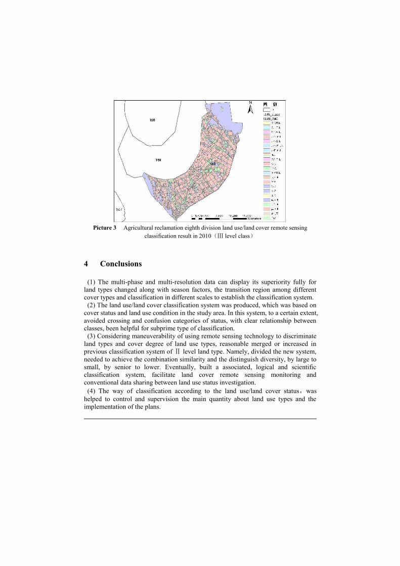
Picture 3 Agricultural reclamation eighth division land use/land cover remote sensing
classification result in 2010(Ⅲ level class)
4 Conclusions
(1) The multi-phase and multi-resolution data can display its superiority fully for
land types changed along with season factors, the transition region among different
cover types and classification in different scales to establish the classification system.
(2) The land use/land cover classification system was produced, which was based on
cover status and land use condition in the study area. In this system, to a certain extent,
avoided crossing and confusion categories of status, with clear relationship between
classes, been helpful for subprime type of classification.
(3) Considering maneuverability of using remote sensing technology to discriminate
land types and cover degree of land use types, reasonable merged or increased in
previous classification system of Ⅱ level land type. Namely, divided the new system,
needed to achieve the combination similarity and the distinguish diversity, by large to
small, by senior to lower. Eventually, built a associated, logical and scientific
classification system, facilitate land cover remote sensing monitoring and
conventional data sharing between land use status investigation.
(4) The way of classification according to the land use/land cover status,was
helped to control and supervision the main quantity about land use types and the
implementation of the plans.
Reference
1. Xiaomei Xiao et al. The Application of the Quickbird Remote Sensing Images to the
Regulation of Kinds of Land Use——By the Example of Anju District, Suining [J].Acta
Geologica Sichuan,2008,28(4):331—334.
2. Yuanjun Xing et al. Investigation on Land Use Based on QuickBird Image [J]. Journal of
Anhui Agricultural Sciences, 2007,35(10):3001—3002,3004.
3. Xiongjie Lv et al. Application Study on QuickBird Image in Investigation of Urban Land
Use Status [J]. Tianjin Agricultural Sciences, 2008.14(2):12—15.
4. S.Ratanopad,W.Kainz. Land Cover Classification and Monitoring in Northeast Thailand
Using LandSat 5 TM Data. International Archives of Photogrammetry, Remote Sensing,
and Spatial Information Sciences,2006,1(2):137—144.
5. Yuhua He et al. FAO/UNEP-Land Cover Classification System (LCCS) and Use for
Reference [J]. China Land Science,2005,19(6):45—49.
6. Pengfeng Xiao et al. A Land Use/ Cover Classification System Based on Medium
Resolution Remote Sensing Data [J]. China Land Science,2006,20(2):33—38.
7. Jan Clevers,Harm Bartholomeus,Sander Mücher & Allard de Wit. Land Cover
Classification with the Medium Resolution Imaging Spectrometer (MERIS) [J]. EARSeL
eProceedings 2004,3(3):354—362.
8. Pengfeng Xiao et al. Methods and Accuracy Assessment for Land Use and Cover
Classification Based on Medium Resolution Remotely Sensed Data [J]. Remote Sensing
for Land & Resources, 2004,4:41—45.
9. Mücher,C.A.,van de Velde,R.J.,and Nieuwenhuis,G.J.A.,1994,Mapping Land Cover for
Environmental Monitoring on a European Scale. Pilot project for the applicability of
NOAA/AVHRR HRPT data .Report 93, SC-DLO, Wageningen , the Netherlands. RIVM
report No. 402001004.
10. Malmberg,U.2001.BALANS Land Cover and Land Use Classification Methodology.
BALANS report Balans-utv-24 2.0,Stockholm,2001.
11. Shefali Agrawal,P.K.Joshi,Yogita Shukla,P.S.Roy. Spot-Vegetation multi temporal data for
classifying vegetation in South Central Asia. Communicated to Current Science Journal,
2003.
12. Anonymous,Forest Cover Assessment in Asia.Proceeding of the International Workshop
Asian Forest Cover Assessment and Conservation Issues,2002.
13. Ling Lu et al. The Mapping and Validation of Land Cover in Northwest China from
SPOT4-VEGETATION [J]. Joural of Remote Sensing, 2003,7(3):214—220.
14. Jianping Li,GUAN Jing-de. The Vegetation Classification of the Return Farmland to
Pasture or Forest Region in Shaanxi-Gansu-Ningxia Based on SPOT/VEGETATION
Data [J]. Agricultural Science & Tchenology,2009,10(5):179—183.
15. Yi Song et al. Study on Vegetation Cover Change in Northwest China Based on SPOT
VEGETATION Data [J]. Journal of Desert Reseatch, 2007,27(1):89—93.
16. Wenting Xu et al. China Land Cover 2000 Using SPOT VGT S10 Data [J]. Joural of
Remote Sensing, 2005,9(2):204—214.
17. Pan Gong et a1.Land Cover Mapping with MODIS NDVI Time-series Data in
Northeastern China [J].The 9thInternational Symposium on Physical Measurements and
Signatures in Remote Sensing, Beijing, China.17-19 0ctober2005. pp:12—415.
18. Aixia Liu et al. Land Cover Classification Based on MODIS Data in Area to the
North—west of Beijing [J]. Progress in Geography, 2006,25(2):96—104.

19. Aixia Liu et al. Method for remote sensing monitoring of desertification based on MODIS
and NOAA/AVHRR data [J]. Transactions of the Chinese Society of Agricultural
Engineering, 2007,23(10):145—150.
20. Pan Gong et a1.On the Classification System of Land Cover in China Based on MODIS
[J]. Journal of QINGDAO University of Science and Technology (SOCIAL SCIENCES),
2007,23(2):79—83.
21. Pan Gong et a1.Progress of the Research on Classification System of Land Vegetation [J].
China Journal of Agricultural Resources and Regional Planning, 2006,27(2):35—40.
22. Anderson J R, Hardy E, Roach J, et a1.A land use and land cover classification system for
use with remote sensing data. U.S. Geological Survey Profession Paper. Washington,
DC.1976.
23. Anderson J R. Toward more effective method of obtaining land use data in geographic
research. The Progressional Geographer, 1961, 13:15—18.
24. Xiping Yuan et al. Comparison and Analysis on Land Cover Remote Sensing Monitoring
and typical Classification System [J]. Joural of YUNNAN Polytechnic University, 1999,15
(4):8—10.
25. Zhanjiang Sha et al. Study on the Methods of Deriving the Information of Land Cover in
the Arid Areas by Using TM Data [J]. Arid Land Geography, 2005,28(1)59—64.
26. LiWen Wang et al. Detecting the Areas at Risk of Desertification in XINJIANG Based on
MODIS NDVI Imagery [J]. Journal of Infrared and Millimeter Waves, 2007.26(6)456—460.
27. Aixia Liu et al. Land use Classification in Arid and Semi-Arid Areas Using CBERS-1
Imagery [J]. Journal of the Graduate School of the Chinese Academy of Science, 2003. 20
(3)334—340.
28. Shu Li. A Synthetical Study on Land Use/Cover Change and Desertification in Arid and
Semiarid Region[D]. LANZHOU University, 2006.