Embed Size (px)
Citation preview

Land Use Safety Study
Carter Street Precinct
For NSW Department of Planning and Environment
12 June 2018
Doc. No.: J-000276-LUSS-REP1
Revision: 0
Arriscar Pty Limited ACN 162 867 763 www.arriscar.com.au
Sydney Level 26 44 Market Street Sydney NSW 2000 T: +61 2 9089 8804
Melbourne Level 2 Riverside Quay 1 Southbank Boulevard Southbank VIC 3006 T: +61 3 9982 4535
Land Use Safety Study: Carter Street Precinct
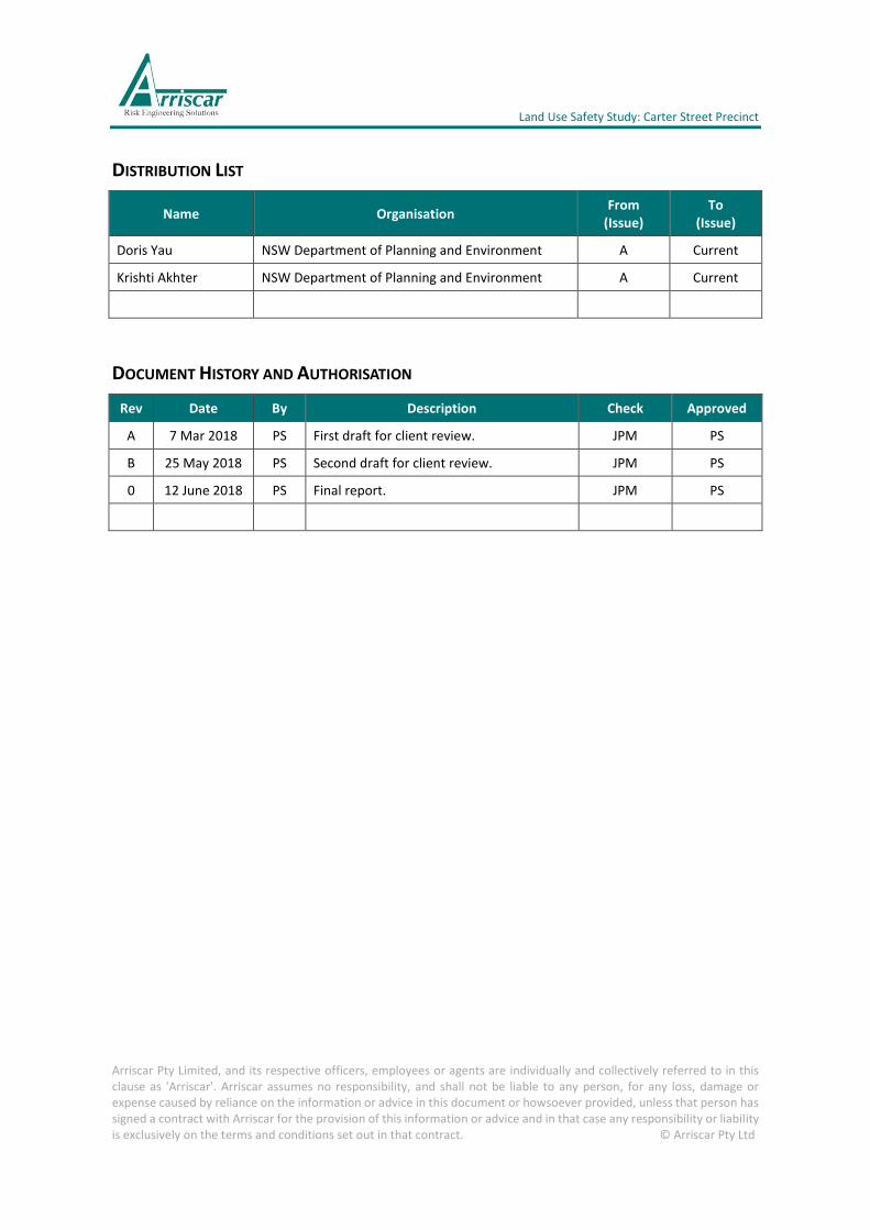
DISTRIBUTION LIST
Name Organisation From
(Issue) To
(Issue)
Doris Yau NSW Department of Planning and Environment A Current
Krishti Akhter NSW Department of Planning and Environment A Current
DOCUMENT HISTORY AND AUTHORISATION
Rev Date By Description Check Approved
A 7 Mar 2018 PS First draft for client review. JPM PS
B 25 May 2018 PS Second draft for client review. JPM PS
0 12 June 2018 PS Final report. JPM PS
Arriscar Pty Limited, and its respective officers, employees or agents are individually and collectively referred to in this clause as 'Arriscar'. Arriscar assumes no responsibility, and shall not be liable to any person, for any loss, damage or expense caused by reliance on the information or advice in this document or howsoever provided, unless that person has signed a contract with Arriscar for the provision of this information or advice and in that case any responsibility or liability is exclusively on the terms and conditions set out in that contract. © Arriscar Pty Ltd

Land Use Safety Study: Carter Street Precinct
Doc Number: J-000276-LUSS-REP1 Page 3 Revision: 0
Summary
Arriscar Pty Ltd (Arriscar) was engaged by the New South Wales (NSW) Department of Planning and
Environment (DP&E) to undertake a Land Use Safety Study (LUSS) for the Carter Street Precinct in
Lidcombe, NSW. The findings of this study will be used to inform the revised Draft Precinct Plan.
The scope of the LUSS included estimation of the risks posed by the existing pipelines in the study
area using Quantitative Risk Assessment (QRA) techniques. The following existing pipelines were
identified to potentially contain hazardous materials and were included in the QRA:
• Natural gas pipelines operated by Jemena Gas.
• A Jet Fuel pipeline operated by Viva Energy.
• The Sydney Metropolitan Pipeline (SMP) operated by Caltex.
• An Ethylene pipeline owned by Qenos.
Most of the proposed land uses in the current indicative masterplan, Local Environmental Plan (LEP)
and Development Control Plan (DCP) comply with the DP&E’s individual risk criteria for land use
safety planning.
Future sensitive use development should not be permitted within the extent of the 0.5 x 10⁻⁶ per
year cumulative individual fatality risk contour and future residential development should not be
permitted within the extent of the 1 x 10⁻⁶ per year cumulative individual fatality risk contour (Refer
to Figure 9). Development applications should be reviewed on a case-by-case basis and should
demonstrate compliance with the DP&E’s qualitative and quantitative risk criteria, including, but
not limited to, cumulative societal risk.
An approved, and yet to be constructed, child care centre is located at the corner of Carter Street
and Birnie Road. This development was approved prior to the LUSS and complies with the current
zoning in the LEP; however, the risk at this location is greater than the DP&E’s risk criterion of 0.5 x
10-6 per year for such a sensitive use development. The consent authority should resolve this
existing land use safety conflict by adopting the principles outlined in Section 4.2.4 of HIPAP No. 10
(Refer to Section 6.1.1).
The societal risk from the pipelines in the study area is tolerable as the cumulative societal risk curve
does not extend beyond the ALARP region (Also refer to Section 3.2.4). However, it is relatively
close to the upper ‘intolerable’ criterion line and future residential intensification beyond that
proposed under the indicative masterplan may be inappropriate.
Three planning proposals have been submitted by land owners (Refer to Section 5). These are
generally consistent with the indicative masterplan and outline land uses that are generally
appropriate based on the DP&E’s risk criteria for land use safety planning.
The proposed risk-based development controls are included in Section 4 and recommendations for
each relevant stakeholder are included in Section 6.
Land Use Safety Study: Carter Street Precinct
Doc Number: J-000276-LUSS-REP1 Page 4 Revision: 0
Contents
Summary..................................................................................................................................................... 3
Notation ..................................................................................................................................................... 6
1 Introduction ...................................................................................................................................... 7
1.1 Background .................................................................................................................................... 7
1.2 Reporting ..................................................................................................................................... 12
1.3 Scope ........................................................................................................................................... 12
1.3.1 Study Area ................................................................................................................................... 12
1.3.2 Scope of the LUSS ........................................................................................................................ 12
1.3.3 Facilities Covered in the QRA ...................................................................................................... 13
1.3.4 Scope of QRA ............................................................................................................................... 13
1.4 Objectives .................................................................................................................................... 14
2 Study Area ....................................................................................................................................... 16
2.1 Carter Street Precinct .................................................................................................................. 16
2.2 Land Use and Indicative Lot Plan ................................................................................................. 16
2.3 Future Population Estimates ....................................................................................................... 17
2.4 Potentially Hazardous Facilities and Operations ......................................................................... 19
3 Risk Assessment .............................................................................................................................. 21
3.1 Introduction ................................................................................................................................. 21
3.2 Risk Criteria for Land Use Safety Planning ................................................................................... 22
3.2.1 Individual Fatality Risk ................................................................................................................. 22
3.2.2 Injury Risk .................................................................................................................................... 22
3.2.3 Risk of Property Damage and Accident Propagation ................................................................... 23
3.2.4 Societal Risk ................................................................................................................................. 23
3.2.5 Qualitative Risk Criteria ............................................................................................................... 24
3.3 Assessment of Risks for Carter Street Precinct............................................................................ 24
3.3.1 Individual Fatality Risk ................................................................................................................. 24
3.3.2 Risk of Acute Toxic Injury or Irritation ......................................................................................... 25
3.3.3 Risk of Property Damage and Accident Propagation (Exceeding 14 kPa) .................................... 25
3.3.4 Risk of Property Damage and Accident Propagation (Exceeding 23 kW/m2) .............................. 25
3.3.5 Risk of Injury (Exceeding 7 kPa) ................................................................................................... 26
3.3.6 Risk of Injury (Exceeding 4.7 kW/m2) .......................................................................................... 26
3.3.7 Qualitative Risk Criteria ............................................................................................................... 26
3.3.8 Societal Risk ................................................................................................................................. 27
4 Risk-Based Development Controls ................................................................................................... 29
Area A – Open Area Adjacent to Haslams Creek ........................................................................................ 32
Area B (B1, B2 and B3) – Enterprise Corridor ............................................................................................. 33
Area C – Recreational Area at Intersection of Hill Road and Carter Street ................................................. 34
Area D – Enterprise Corridor (East of Birnie Avenue) ................................................................................ 35
Area E – Residential Areas Fronting Carter Street ..................................................................................... 36
5 Planning Proposals .......................................................................................................................... 37
5.1 Introduction ................................................................................................................................. 37
5.2 Meriton Group’s Urban Design Report for 1-13 Carter Street and 23 Uhrig Road ..................... 37
Land Use Safety Study: Carter Street Precinct
Doc Number: J-000276-LUSS-REP1 Page 5 Revision: 0
5.3 AYMCI’s Submission to DPE / Master Plan Review ...................................................................... 39
5.4 SLA’s Urban Design Analysis and Masterplan Concept for 12-14 Birnie Avenue ........................ 40
6 Findings and Recommendations ...................................................................................................... 43
6.1 Findings ........................................................................................................................................ 43
6.1.1 Risk Assessment........................................................................................................................... 43
6.1.2 Planning Proposals ...................................................................................................................... 43
6.1.3 Risk-Based Development Controls .............................................................................................. 44
6.2 Recommendations ....................................................................................................................... 44
7 References ...................................................................................................................................... 46
Appendix A Land Use Zones from Auburn LEP ................................................................................. 48
A.1 Zone B2 Local Centre ................................................................................................................. 48
A.2 Zone B6 Enterprise Corridor ...................................................................................................... 48
A.3 Zone R4 High Density Residential .............................................................................................. 49
A.4 Zone RE1 Public Recreation ....................................................................................................... 50
A.5 Zone SP2 Infrastructure ............................................................................................................. 50
List of Figures
Figure 1 Land Use Zones from Auburn LEP [Ref. 7] ..................................................................................... 9
Figure 2 Existing Indicative Structure Plan, from 2016 DCP [Ref. 2] ......................................................... 10
Figure 3 Draft Indicative Structure Plan .................................................................................................... 11
Figure 4 Study Area [Ref. 3] ....................................................................................................................... 15
Figure 5 Draft Indicative Lot Plan [Ref. 6] .................................................................................................. 17
Figure 6 Approximate Pipeline Locations .................................................................................................. 20
Figure 7 Overview of QRA Process [Ref. 4] ................................................................................................ 21
Figure 8 Indicative Societal Risk Criteria .................................................................................................... 23
Figure 9 Cumulative Individual Fatality Risk .............................................................................................. 25
Figure 10 Societal Risk FN Curve ................................................................................................................. 28
Figure 11 Areas Requiring Specific Risk-Based Planning Controls ............................................................... 31
Figure 12 Four Phases of Meriton Group’s Planning Proposal [Ref. 8] ....................................................... 38
Figure 13 Site of AYMCI’s Planning Proposal [Ref. 1] .................................................................................. 39
Figure 14 Site of SLA’s Planning Proposal [Ref. 9] ....................................................................................... 40
List of Tables
Table 1 Total Estimated Future Residential Population in Study Area ..................................................... 18
Table 2 Total Estimated Non-Residential Population in Study Area ........................................................ 19
Table 3 Individual Fatality Risk Criteria .................................................................................................... 22

Land Use Safety Study: Carter Street Precinct
Doc Number: J-000276-LUSS-REP1 Page 6 Revision: 0
Notation
Abbreviation Description
Arriscar Arriscar Pty Ltd
DA Development Application
DCP Development Control Plan
DP&E NSW Department of Planning and Environment
HAZID Hazard Identification
HIPAP Hazardous Industry Planning Advisory Paper
LEP Local Environmental Plan
LSIR Location-Specific Individual Risk
LSIFR Location-Specific Individual Fatality Risk
LUSS Land Use Safety Study
MAE Major Accident Event
NSW New South Wales
PHA Preliminary Hazard Analysis
pmpy per million per year (Note: 1 pmpy = 1 x 10⁻⁶ per year)
QRA Quantitative Risk Assessment
RA Risk Analysis
SEPP State Environmental Planning Policy
VCE Vapour Cloud Explosion
VPA Voluntary Planning Agreement
Land Use Safety Study: Carter Street Precinct
Doc Number: J-000276-LUSS-REP1 Page 7 Revision: 0
1 INTRODUCTION
1.1 Background
Arriscar Pty Ltd (Arriscar) was engaged by the New South Wales (NSW) Department of Planning and
Environment (DP&E) to undertake a Land Use Safety Study (LUSS) for the Carter Street Precinct in
Lidcombe, NSW. The findings of this study will be used to inform the revised Draft Precinct Plan and
future rezoning.
Existing Carter Street Precinct Plan
In November 2015, the Carter Street Precinct was rezoned to enable redevelopment for:
• a high density urban community with a minimum of 5,500 dwellings, including a range of
housing options and buildings with maximum heights up to 29.9m (8 storeys) to 72m (22
storeys);
• employment uses along the M4 Motorway corridor, within building heights up to 24m (6
storeys);
• a mixed-use village centre and village square focused around Uhrig Road;
• a new primary school;
• a community facility; and
• new public open space, including a 2.98-hectare open space area adjoining the proposed
school site, a village park on Uhrig Road, and a new linear foreshore reserve along Haslams
Creek south of John Ian Wing Parade.
The rezoning incorporated new land use zones and controls into Auburn Local Environmental Plan
(LEP) 2010 [Ref. 7] and a Development Control Plan (DCP) [Ref. 2]. The land use zone map from the
LEP is reproduced below in Figure 1 and the indicative structure plan from the 2016 DCP is
reproduced below in Figure 2.
Since rezoning, several Development Applications (DAs) within the eastern portion of the precinct
have been approved or are being assessed by the City of Parramatta. These applications relate to
both subdivision and construction of buildings. Some landowners have prepared preliminary
planning proposals / master plans for their sites, mainly seeking additional uplift.
Hill Road Off Ramp
In late November 2015, the NSW Government committed funding for the new westbound off-ramp
from the M4 Motorway at Hill Road. The new westbound off ramp requires road widening outside
of the existing road corridor within both the Carter Street Precinct and Sydney Olympic Park.
However, the design of the offramp has since changed in late 2017.
Draft Carter Street Precinct Plan
The Department has prepared a revised draft Precinct Plan to accommodate the proposed changes
to the design of Hill Road and the M4 Motorway westbound off ramp. The proposed land use for
the draft Precinct Plan formed the basis for the QRA.
The draft Precinct Plan retains the total floor space available under existing controls (around a
minimum 5,500 dwellings) but proposes to relocate the school site from the north of the planned
major public open space to its eastern side, to improve its relationship with the open space and
planned village centre along Uhrig Road.

Land Use Safety Study: Carter Street Precinct
Doc Number: J-000276-LUSS-REP1 Page 8 Revision: 0
Other key proposed changes include expanding the major public open space from 2.98 hectares to
3.4 hectares and relocating residential floor space from the northern part of the Precinct’s boundary
closer to Carter Street, to reduce overshadowing and provide increased amenity. It is also proposed
to increase the maximum building height at the site at 2 Hill Road, located in the Precinct’s western
edge, to enable floor space on the site to be moved away from the pipeline easement.
The revised draft Indicative Structure Plan is shown at Figure 3.
Sydney Olympic Park Master Plan 2030 (2016 Review)
The draft Carter Street Precinct Plan supports Sydney Olympic Park as the urban hub of the Olympic
Peninsula. As part of the remaster planning process for the Carter Street Precinct, opportunities to
better integrate the two precincts are being explored.
The DP&E intends to prepare a new State Environmental Planning Policy (SEPP) that will amend the
Auburn Local Environmental Plan 2010, as it relates to the Carter Street Precinct.

Land Use Safety Study: Carter Street Precinct
Doc Number: J-000276-LUSS-REP1 Page 9 Revision: 0
Figure 1 Land Use Zones from Auburn LEP [Ref. 7]

Land Use Safety Study: Carter Street Precinct
Doc Number: J-000276-LUSS-REP1 Page 10 Revision: 0
Figure 2 Existing Indicative Structure Plan, from 2016 DCP [Ref. 2]

Land Use Safety Study: Carter Street Precinct
Doc Number: J-000276-LUSS-REP1 Page 11 Revision: 0
Figure 3 Draft Indicative Structure Plan

Land Use Safety Study: Carter Street Precinct
Doc Number: J-000276-LUSS-REP1 Page 12 Revision: 0
1.2 Reporting
The LUSS included a Quantitative Risk Assessment (QRA) of the natural gas, fuel and ethylene
pipelines located in the study area. Two reports were prepared by Arriscar to separate the detailed
technical risk analysis aspects from the strategic land use safety planning aspects:
1. A Risk Analysis (RA) report, which includes an estimation of the risks associated with the
natural gas, fuel and ethylene pipelines located in the study area.
2. A Land Use Safety Study (LUSS) report, which includes an assessment of the risks associated
with the natural gas, fuel and ethylene pipelines and identifies the land use safety planning
implications for the study area.
The ‘analysis’ steps of the QRA are included in the separate RA report. This analysis has been
undertaken in accordance with the guidance provided by the NSW DP&E in Hazardous Industry
Planning Advisory Paper (HIPAP) No. 6 - Hazard Analysis (2011).
This report is for the LUSS and includes the ‘assessment’ steps of the QRA. The quantitative
assessment of the risk has been undertaken in accordance with the criteria published by the DP&E
in HIPAP No. 4 - Risk Criteria for Land Use Safety Planning (2011) and HIPAP No. 10 – Land Use Safety
Planning (2011) (Refer to Section 3.2).
1.3 Scope
1.3.1 Study Area
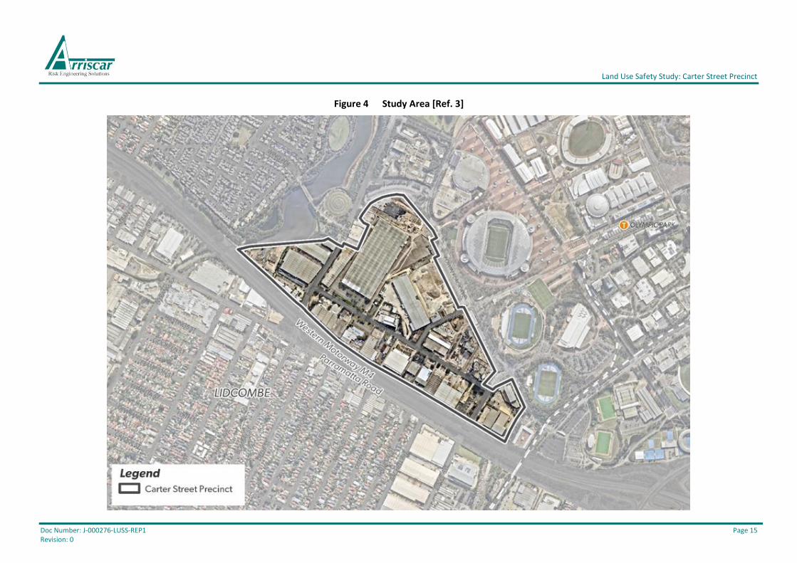
The study area for the LUSS and QRA includes the land identified in Figure 4 (Bordered by yellow
line). It includes land within the Carter Street Precinct.
1.3.2 Scope of the LUSS
The scope of the LUSS included:
1. A review of the previous safety related studies undertaken for the study area (including
Safety Management System and other risk studies) and consultation with pipeline owners
to identify the current pipeline status.
2. Estimation of the risks posed by the existing pipelines in the study area using QRA
techniques. The modelling was based on the information provided by the Urban Renewal
Team (including population density, proposed location of land uses and other relevant
information).
3. A review of landowner’s preliminary planning proposals in the context of the QRA results to
establish if these are consistent with the relevant risk criteria for land use safety planning.
4. Providing advice and justification on the preferred location of land uses (including
residential commercial, retail and education uses) and other planning controls (including
setbacks if needed), in the context of the QRA results and consistent with the risk criteria
for land use safety planning published in HIPAP No 10.
5. A review of the existing draft planning controls for the area and, where necessary
recommending amendments to the proposed standards and planning controls for the study
area.

Land Use Safety Study: Carter Street Precinct
Doc Number: J-000276-LUSS-REP1 Page 13 Revision: 0
Responding to any issues raised in submissions regarding hazards and risks following public
exhibition of the revised precinct and development control plan was excluded from the scope of
work at this stage.
1.3.3 Facilities Covered in the QRA
The scope of the LUSS (Refer to Section 1.3.2), included estimation of the risks posed by the existing
pipelines in the study area using QRA techniques. Any potentially hazardous facilities outside the
study area (e.g. liquid waste treatment plant) were excluded from the QRA and the scope of the
LUSS.
The following existing pipelines were identified to potentially contain hazardous materials and were
included in the scope of the QRA:
• Natural gas pipelines operated by Jemena Gas.
• A Jet Fuel pipeline operated by Viva Energy.
• The Sydney Metropolitan Pipeline (SMP) operated by Caltex.
• An Ethylene pipeline owned by Qenos (Licenced but not currently in operation).
Some non-operational pipelines were identified during the study and were excluded from the scope
of the QRA. This included the Viva 500 pipeline and an unlicensed Naphtha pipeline.
Some segments of the Viva 500 pipeline have been laid along the pipeline route from Clyde to
Botany; however, these segments have not been connected and the pipeline has not been used (The
Viva 500 pipeline was laid as a conduit for a potential future pipeline utilising the pipeline
easement). It was agreed with DP&E to exclude this pipeline from the scope of the QRA.
It was agreed with DP&E to include the Ethylene pipeline in the QRA since Qenos holds a current
operating licence. This pipeline, which does not currently contain Ethylene, is unlikely to be used
for Ethylene since the Clyde refinery and Basell plastics plant have been decommissioned and
demolished.
Other facilities and operations in the study area (e.g. electrical substation) were excluded from the
scope of the QRA; however, the potential for these to affect the existing pipelines was considered
during hazard identification. Natural hazards (e.g. flooding, lightning, etc.) were also considered
during the hazard identification.
1.3.4 Scope of QRA
The scope of the QRA included a quantitative analysis and assessment of the fatality, injury, property
damage and biophysical environment damage risks for which the DP&E has specified risk criteria in
HIPAP No. 4 and HIPAP No. 10. The QRA did not include an assessment of the following risks:
• Risks to the biophysical environment associated with ongoing operation and maintenance
of the existing pipelines (These are existing risks that are not relevant for the scope of the
LUSS);
• Risk of damage to infrastructure and utilities in or near the pipeline easements (e.g.
electrical power or water supply);
• Fatality or injury risks for personnel involved with the construction of new infrastructure
(e.g. Hill Road off ramp) or new buildings in the study area and/or personnel who damage
the existing pipelines;

Land Use Safety Study: Carter Street Precinct
Doc Number: J-000276-LUSS-REP1 Page 14 Revision: 0
• Risks during the construction and redevelopment phase (i.e. The QRA is for the final state
of precinct redevelopment as described in Section 2); and
• Fatality or injury risks for personnel involved with the ongoing operation and maintenance
of the existing pipelines.
1.4 Objectives
The principal objective of the study was to perform a QRA and LUSS covering the scope outlined in
Section 1.3 and in accordance with the NSW HIPAP guidelines. For the QRA, this included:
• Identification of the hazards for all potentially hazardous substances in the existing
pipelines;
• Identification of all ‘Major Accident Events’ (MAEs) resulting in loss of containment, fire,
explosion and/or toxic releases from the existing pipelines, and the appropriate and
relevant representative scenarios for each MAE;
• Quantification of the consequences of potential harmful effects for each representative
scenario, including the potential for impact on surrounding land uses;
• Quantification of the likelihood of occurrence of each representative scenario;
• Using assumptions that are appropriate and justified, with a focus on minimising uncertainty
and obtaining the ‘cautious best estimate’;
• Generation of Location-Specific Individual Risk (LSIR) contours for comparison with the
DP&E’s risk criteria for land use safety planning (viz. as per HIPAP No. 4 and HIPAP No. 10);
and
• Estimation of societal risk for comparison with the DP&E’s indicative risk criteria for land
use safety planning (viz. as per HIPAP No. 4 and HIPAP No. 10).
Land Use Safety Study: Carter Street Precinct
Doc Number: J-000276-LUSS-REP1 Page 15 Revision: 0
Figure 4 Study Area [Ref. 3]

Land Use Safety Study: Carter Street Precinct
Doc Number: J-000276-LUSS-REP1 Page 16 Revision: 0
2 STUDY AREA
2.1 Carter Street Precinct
The Carter Street Precinct includes 52 hectares of land directly south west of Sydney Olympic Park.
The precinct is an established industrial area with mainly large warehouse facilities offering logistics
services.
Carter Street is the main east‐west road through the precinct, while Uhrig Road links with Sydney
Olympic Park. Entry to the precinct is currently available from the M4 Motorway and Parramatta
Road at Hill Road and from Parramatta Road at Birnie Avenue.
2.2 Land Use and Indicative Lot Plan
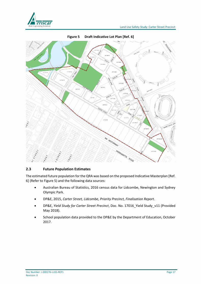
The land use for the QRA is based on the draft Indicative Lot Plan [Ref. 6] (Refer to Figure 5) and the
draft Indicative Structure Plan (Refer to Figure 2).
The Indicative Masterplan is similar to the Indicative Structure Plan from the 2016 Carter Street
Precinct DCP (Refer to Figure 2), with similar zoning to the Auburn 2010 LEP (Refer to Figure 1). For
example, commercial uses are still proposed to be located to the south of Carter Street and high-
rise residential and local centre uses are still proposed to be located to north of Carter Street. The
main differences in the Indicative Masterplan include:
• relocation of the school to be adjacent to the central park (which will be used by the school
for outdoor activities); and,
• the introduction of a light rail system along Uhrig Road (Note: This terminates before
reaching Carter Street).
Land Use Safety Study: Carter Street Precinct
Doc Number: J-000276-LUSS-REP1 Page 17 Revision: 0
Figure 5 Draft Indicative Lot Plan [Ref. 6]
2.3 Future Population Estimates
The estimated future population for the QRA was based on the proposed Indicative Masterplan [Ref.
6] (Refer to Figure 5) and the following data sources:
• Australian Bureau of Statistics, 2016 census data for Lidcombe, Newington and Sydney
Olympic Park.
• DP&E, 2015, Carter Street, Lidcombe, Priority Precinct, Finalisation Report.
• DP&E, Yield Study for Carter Street Precinct, Doc. No. 17016_Yield Study_v11 (Provided
May 2018).
• School population data provided to the DP&E by the Department of Education, October
2017.
Land Use Safety Study: Carter Street Precinct
Doc Number: J-000276-LUSS-REP1 Page 18 Revision: 0
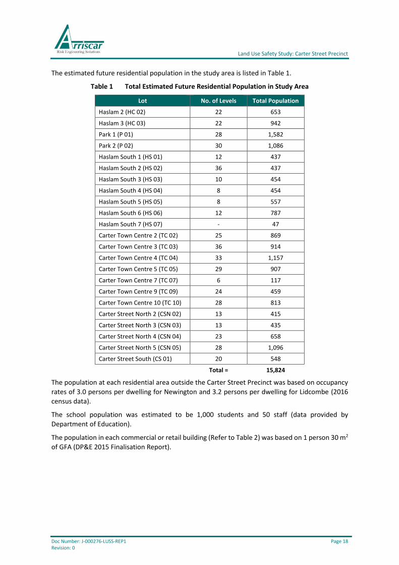
The estimated future residential population in the study area is listed in Table 1.
Table 1 Total Estimated Future Residential Population in Study Area
Lot No. of Levels Total Population
Haslam 2 (HC 02) 22 653
Haslam 3 (HC 03) 22 942
Park 1 (P 01) 28 1,582
Park 2 (P 02) 30 1,086
Haslam South 1 (HS 01) 12 437
Haslam South 2 (HS 02) 36 437
Haslam South 3 (HS 03) 10 454
Haslam South 4 (HS 04) 8 454
Haslam South 5 (HS 05) 8 557
Haslam South 6 (HS 06) 12 787
Haslam South 7 (HS 07) - 47
Carter Town Centre 2 (TC 02) 25 869
Carter Town Centre 3 (TC 03) 36 914
Carter Town Centre 4 (TC 04) 33 1,157
Carter Town Centre 5 (TC 05) 29 907
Carter Town Centre 7 (TC 07) 6 117
Carter Town Centre 9 (TC 09) 24 459
Carter Town Centre 10 (TC 10) 28 813
Carter Street North 2 (CSN 02) 13 415
Carter Street North 3 (CSN 03) 13 435
Carter Street North 4 (CSN 04) 23 658
Carter Street North 5 (CSN 05) 28 1,096
Carter Street South (CS 01) 20 548
Total = 15,824
The population at each residential area outside the Carter Street Precinct was based on occupancy
rates of 3.0 persons per dwelling for Newington and 3.2 persons per dwelling for Lidcombe (2016
census data).
The school population was estimated to be 1,000 students and 50 staff (data provided by
Department of Education).
The population in each commercial or retail building (Refer to Table 2) was based on 1 person 30 m2
of GFA (DP&E 2015 Finalisation Report).
Land Use Safety Study: Carter Street Precinct
Doc Number: J-000276-LUSS-REP1 Page 19 Revision: 0
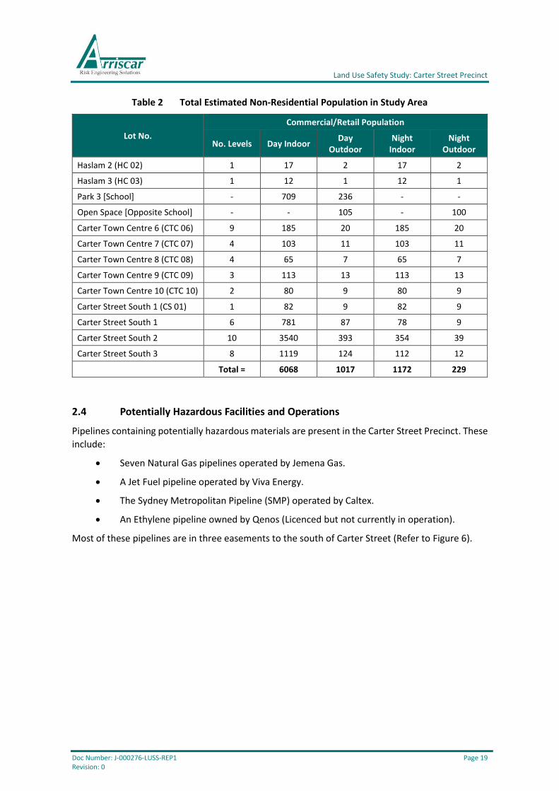
Table 2 Total Estimated Non-Residential Population in Study Area
Lot No.
Commercial/Retail Population
No. Levels Day Indoor Day
Outdoor Night
Indoor Night
Outdoor
Haslam 2 (HC 02) 1 17 2 17 2
Haslam 3 (HC 03) 1 12 1 12 1
Park 3 [School] - 709 236 - -
Open Space [Opposite School] - - 105 - 100
Carter Town Centre 6 (CTC 06) 9 185 20 185 20
Carter Town Centre 7 (CTC 07) 4 103 11 103 11
Carter Town Centre 8 (CTC 08) 4 65 7 65 7
Carter Town Centre 9 (CTC 09) 3 113 13 113 13
Carter Town Centre 10 (CTC 10) 2 80 9 80 9
Carter Street South 1 (CS 01) 1 82 9 82 9
Carter Street South 1 6 781 87 78 9
Carter Street South 2 10 3540 393 354 39
Carter Street South 3 8 1119 124 112 12
Total = 6068 1017 1172 229
2.4 Potentially Hazardous Facilities and Operations
Pipelines containing potentially hazardous materials are present in the Carter Street Precinct. These
include:
• Seven Natural Gas pipelines operated by Jemena Gas.
• A Jet Fuel pipeline operated by Viva Energy.
• The Sydney Metropolitan Pipeline (SMP) operated by Caltex.
• An Ethylene pipeline owned by Qenos (Licenced but not currently in operation).
Most of these pipelines are in three easements to the south of Carter Street (Refer to Figure 6).
Land Use Safety Study: Carter Street Precinct
Doc Number: J-000276-LUSS-REP1 Page 20 Revision: 0
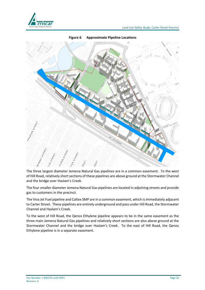
Figure 6 Approximate Pipeline Locations
The three largest diameter Jemena Natural Gas pipelines are in a common easement. To the west
of Hill Road, relatively short sections of these pipelines are above ground at the Stormwater Channel
and the bridge over Haslam’s Creek.
The four smaller diameter Jemena Natural Gas pipelines are located in adjoining streets and provide
gas to customers in the precinct.
The Viva Jet Fuel pipeline and Caltex SMP are in a common easement, which is immediately adjacent
to Carter Street. These pipelines are entirely underground and pass under Hill Road, the Stormwater
Channel and Haslam’s Creek.
To the west of Hill Road, the Qenos Ethylene pipeline appears to be in the same easement as the
three main Jemena Natural Gas pipelines and relatively short sections are also above ground at the
Stormwater Channel and the bridge over Haslam’s Creek. To the east of Hill Road, the Qenos
Ethylene pipeline is in a separate easement.

Land Use Safety Study: Carter Street Precinct
Doc Number: J-000276-LUSS-REP1 Page 21 Revision: 0
3 RISK ASSESSMENT
3.1 Introduction
Land use safety planning (including the development of planning controls) for the Study Area,
requires an understanding of the hazards and risks posed by the relevant potentially hazardous
operations. The risk analysis undertaken for the LUSS involved the quantitative estimation of the
consequences and likelihood of accidents (viz. a Quantitative Risk Assessment or QRA).
Diagrammatically, the QRA process is as follows:
Figure 7 Overview of QRA Process [Ref. 4]
A review of previous safety related studies was undertaken for the Study Area and the pipeline
operators were consulted with to identify the current pipeline status and operating parameters
required for the QRA (e.g. operating pressure, pipeline diameter, pipeline wall thickness, etc.).
The QRA was also based on the information provided by the DP&E’s Urban Renewal Team (including
population density, proposed location of land uses and other relevant information).
A hazard and risk analysis cannot be carried out in isolation and requires criteria against which the
acceptability of the estimated risk can be assessed. Qualitative and quantitative risk criteria for land
use safety planning have been established in NSW by the Department of Planning & Environment
(DP&E) and these apply for three broad contexts [Ref. 4 (Section 2.1.4) and Ref. 5 (Section 5.1.2)]:
1. Strategic planning (Zoning and rezoning).
2. Assessment of development for potentially hazardous development.
3. Assessment of development in the vicinity of potentially hazardous development.
The qualitative and quantitative risk criteria for land use safety planning currently established in
NSW, which may be common to more than one context, are summarised in Section 3.2.
As
se
ss
me
nt
An
aly
sis
Hazard
Identification
Estimate
Likelihood
Estimate
Consequences
Calculate RiskCompare
Against Criteria
Consider Risk
Mitigation and
Management
Options
Compare
Against Criteria
Consider Risk
Mitigation and
Management
Options
Land Use Safety Study: Carter Street Precinct
Doc Number: J-000276-LUSS-REP1 Page 22 Revision: 0
3.2 Risk Criteria for Land Use Safety Planning
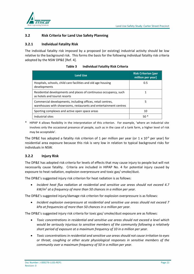
3.2.1 Individual Fatality Risk
The individual fatality risk imposed by a proposed (or existing) industrial activity should be low
relative to the background risk. This forms the basis for the following individual fatality risk criteria
adopted by the NSW DP&E [Ref. 4].
Table 3 Individual Fatality Risk Criteria
Land Use Risk Criterion [per million per year]
Hospitals, schools, child care facilities and old age housing developments
0.5
Residential developments and places of continuous occupancy, such as hotels and tourist resorts
1
Commercial developments, including offices, retail centres, warehouses with showrooms, restaurants and entertainment centres
5
Sporting complexes and active open space areas 10
Industrial sites 50 *
* HIPAP 4 allows flexibility in the interpretation of this criterion. For example, ‘where an industrial site
involves only the occasional presence of people, such as in the case of a tank farm, a higher level of risk
may be acceptable’.
The DP&E has adopted a fatality risk criterion of 1 per million per year (or 1 x 10⁻⁶ per year) for
residential area exposure because this risk is very low in relation to typical background risks for
individuals in NSW.
3.2.2 Injury Risk
The DP&E has adopted risk criteria for levels of effects that may cause injury to people but will not
necessarily cause fatality. Criteria are included in HIPAP No. 4 for potential injury caused by
exposure to heat radiation, explosion overpressure and toxic gas/ smoke/dust.
The DP&E’s suggested injury risk criterion for heat radiation is as follows:
• Incident heat flux radiation at residential and sensitive use areas should not exceed 4.7
kW/m2 at a frequency of more than 50 chances in a million per year.
The DP&E’s suggested injury/damage risk criterion for explosion overpressure is as follows:
• Incident explosion overpressure at residential and sensitive use areas should not exceed 7
kPa at frequencies of more than 50 chances in a million per year.
The DP&E’s suggested injury risk criteria for toxic gas/ smoke/dust exposure are as follows:
• Toxic concentrations in residential and sensitive use areas should not exceed a level which
would be seriously injurious to sensitive members of the community following a relatively
short period of exposure at a maximum frequency of 10 in a million per year.
• Toxic concentrations in residential and sensitive use areas should not cause irritation to eyes
or throat, coughing or other acute physiological responses in sensitive members of the
community over a maximum frequency of 50 in a million per year.
Land Use Safety Study: Carter Street Precinct
Doc Number: J-000276-LUSS-REP1 Page 23 Revision: 0
3.2.3 Risk of Property Damage and Accident Propagation
Heat radiation exceeding 23 kW/m2 may cause unprotected steel to suffer thermal stress that may
cause structural damage and an explosion overpressure of 14 kPa can cause damage to piping and
low-pressure equipment. The DP&E’s criteria for risk of damage to property and accident
propagation are as follows:
• Incident heat flux radiation at neighbouring potentially hazardous installations or at land
zoned to accommodate such installations should not exceed a risk of 50 in a million per year
for the 23 kW/m2 heat flux level.
• Incident explosion overpressure at neighbouring potentially hazardous installations, at land
zoned to accommodate such installations or at nearest public buildings should not exceed a
risk of 50 in a million per year for the 14 kPa explosion overpressure level.
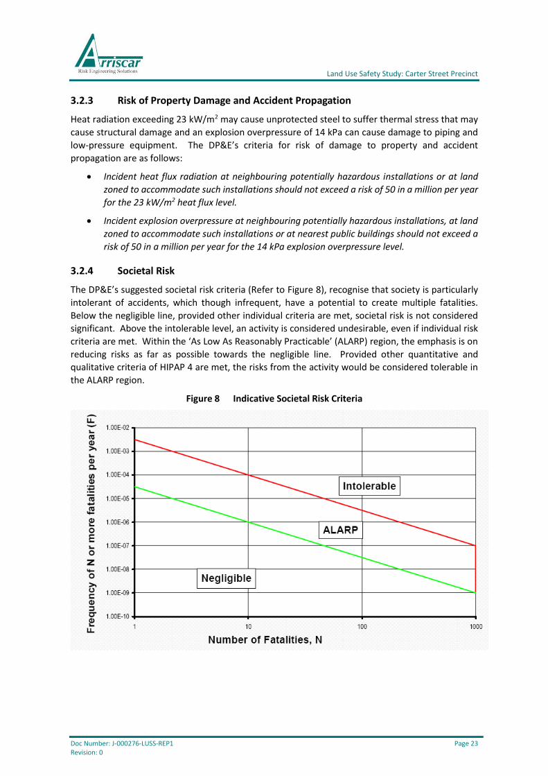
3.2.4 Societal Risk
The DP&E’s suggested societal risk criteria (Refer to Figure 8), recognise that society is particularly
intolerant of accidents, which though infrequent, have a potential to create multiple fatalities.
Below the negligible line, provided other individual criteria are met, societal risk is not considered
significant. Above the intolerable level, an activity is considered undesirable, even if individual risk
criteria are met. Within the ‘As Low As Reasonably Practicable’ (ALARP) region, the emphasis is on
reducing risks as far as possible towards the negligible line. Provided other quantitative and
qualitative criteria of HIPAP 4 are met, the risks from the activity would be considered tolerable in
the ALARP region.
Figure 8 Indicative Societal Risk Criteria
Land Use Safety Study: Carter Street Precinct
Doc Number: J-000276-LUSS-REP1 Page 24 Revision: 0
3.2.5 Qualitative Risk Criteria
Irrespective of the numerical value of any risk criteria level for risk assessment purposes, it is
essential that certain qualitative principles be adopted concerning the land use safety acceptability
of a proposed development or existing activity. The qualitative risk criteria outlined in HIPAP No. 4
encompass the following general principles:
• Avoidance of all ‘avoidable’ risks;
• Reduction, wherever practicable, of the risk from a major hazard, even where the
likelihood of exposure is low;
• Containment, wherever possible, within the site boundary of the effects (consequences)
of the more likely hazardous events; and,
• Recognition that if the risk from an existing installation is already high, further
development should not be permitted if it significantly increases that existing risk.
3.3 Assessment of Risks for Carter Street Precinct
3.3.1 Individual Fatality Risk
The cumulative individual fatality risk contours for all the pipelines included in the QRA for the study
area are shown on Figure 9.
Whilst the cumulative individual fatality risk contours generally comply with the DP&E’s relevant
risk criteria for the indicative masterplan (Refer to Section 3.2.1), there is a small encroachment (c.
15 m) of the 1 x 10⁻⁶ per year individual fatality risk contour into the residential lots to the west and
east of Hill Road on the northern side of Carter Street (Refer to Figure 9). However, the cumulative
fatality risk is less than the relevant DP&E criterion for most of the lot area, particularly where
residences are likely to be located. In accordance with Section 2.1.4 of HIPAP No. 4, this is
considered acceptable.
The 0.5 x10⁻⁶ per year contour extends approximately 80 m beyond the northern boundary of Carter
Street (i.e. from curb on north side of the street) and does not reach the proposed location of the
school on the indicative masterplan (Refer to Figure 9).
The cumulative individual fatality risk at the nearest sensitive use (viz. an approved, and yet to be
occupied, child care centre near the intersection of Carter Street and Birnie Road – Refer to Figure
9) is greater than the DP&E’s risk criterion of 0.5 x10⁻⁶ per year for such a sensitive use development.
The maximum cumulative individual fatality risk in the study area is approximately 2 x 10⁻⁶ per year
and this only occurs at the pipe bridge over Haslams Creek. Therefore, the DP&E’s individual fatality
risk criteria for commercial, open space and industrial uses (viz. 5 x 10⁻⁶, 10 x 10-6 and 50 x 10-6 per
year, respectively - Refer to Section 3.2.1) are fully complied with for the indicative masterplan.

Land Use Safety Study: Carter Street Precinct
Doc Number: J-000276-LUSS-REP1 Page 25 Revision: 0
Figure 9 Cumulative Individual Fatality Risk
3.3.2 Risk of Acute Toxic Injury or Irritation
No credible events with the potential to cause acute toxic injury or irritation were identified for
inclusion in the risk analysis. Therefore, the cumulative risk of acute toxic injury or irritation
complies with the relevant DP&E risk criteria (Refer to Section 3.2.2).
3.3.3 Risk of Property Damage and Accident Propagation (Exceeding 14 kPa)
There are no “neighbouring potentially hazardous installations” or “land zoned to accommodate
such installations” in the study area; therefore, the DP&E criterion for property damage and accident
propagation (overpressure exceeding 14 kPa) is not applicable. Notwithstanding that the DP&E
criterion is not applicable, the cumulative risk of property damage and accident propagation
(overpressure exceeding 14 kPa) does not reach 50 pmpy at any location in the study area.
The cumulative risk of property damage and accident propagation (overpressure exceeding 14 kPa)
complies with the relevant DP&E risk criterion (Refer to Section 3.2.3).
3.3.4 Risk of Property Damage and Accident Propagation (Exceeding 23 kW/m2)
There are no “neighbouring potentially hazardous installations” or “land zoned to accommodate
such installations” in the study area; therefore, the DP&E criterion for property damage and accident
propagation (Heat radiation exceeding 23 kW/m2) is not applicable. Notwithstanding that the DP&E
criterion is not applicable, the cumulative risk of property damage and accident propagation (Heat
radiation exceeding 23 kW/m2) does not reach 50 pmpy at any location in the study area.
1 x 10⁻⁶ p.a.
0.5 x 10⁻⁶ p.a.
School Pipe
Bridge
Child Care
Centre
Land Use Safety Study: Carter Street Precinct
Doc Number: J-000276-LUSS-REP1 Page 26 Revision: 0
The cumulative risk of property damage and accident propagation (Heat radiation exceeding 23
kW/m2) complies with the relevant DP&E risk criterion (Refer to Section 3.2.3).
3.3.5 Risk of Injury (Exceeding 7 kPa)
The cumulative risk of injury (overpressure exceeding 7 kPa) does not reach 50 pmpy at any location
in the study area.
The cumulative risk of injury (overpressure exceeding 7 kPa) complies with the relevant DP&E risk
criterion (Refer to Section 3.2.2).
3.3.6 Risk of Injury (Exceeding 4.7 kW/m2)
The cumulative risk of injury (Heat radiation exceeding 4.7 kW/m2) does not reach 50 pmpy at any
location in the study area.
The cumulative risk of injury (Heat radiation exceeding 4.7 kW/m2) complies with the relevant DP&E
risk criterion (Refer to Section 3.2.2).
3.3.7 Qualitative Risk Criteria
The qualitative risk criteria outlined in HIPAP No. 4 encompass the following general principles:
• Avoidance of all ‘avoidable’ risks;
• Reduction, wherever practicable, of the risk from a major hazard, even where the
likelihood of exposure is low;
• Containment, wherever possible, within the site boundary of the effects (consequences)
of the more likely hazardous events; and,
• Recognition that if the risk from an existing installation is already high, further
development should not be permitted if it significantly increases that existing risk.
In this case, the pipelines are existing facilities rather than proposed developments. Additional risk
reduction is not practicable (except possibly for minimising exposure – Refer to recommendations
in Section 6) and there is no ‘site boundary’ as such (the easements are too small and accessible to
contain the effects of events involving the pipelines).
The cumulative individual fatality risk and societal risk are significant. Development beyond that
proposed in the indicative masterplan should not be permitted in some areas (e.g. sensitive use
developments adjacent to Carter Street) and population intensification beyond the levels presented
in Section 2.2 should be avoided. Development controls should be developed with an understanding
that residential development, development with sensitive uses and population intensification
should be discouraged within some areas of the Precinct. This is the basis for the proposed risk-
based development controls in Section 4.
The established zoning and indicative masterplan provide limited scope to apply the avoidance of
all ‘avoidable’ risk criterion. For example, high density residential uses are already permitted along
Carter Street (north side) and it is no longer practicable to re-zone for a lower population density.
However, ensuring that commercial uses are retained along Carter Street (south side) is practicable
and consistent with the established zoning and indicative masterplan and would comply with the
avoidance of all ‘avoidable’ risk criterion. This is reflected in the proposed risk-based development
controls in Section 4.

Land Use Safety Study: Carter Street Precinct
Doc Number: J-000276-LUSS-REP1 Page 27 Revision: 0
3.3.8 Societal Risk
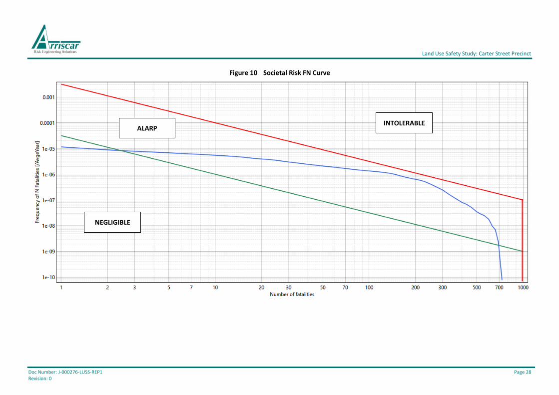
The cumulative societal risk curve for all the pipelines in the study area is shown in Figure 10.
As the quantitative and qualitative risk criteria from HIPAP No. 4 are met, the societal risk from the
pipelines in the study area is tolerable as the cumulative societal risk curve does not extend beyond
the ALARP region (Also refer to Section 3.2.4). However, it is relatively close to the upper
‘intolerable’ criterion line.
Land Use Safety Study: Carter Street Precinct
Doc Number: J-000276-LUSS-REP1 Page 28 Revision: 0
Figure 10 Societal Risk FN Curve
NEGLIGIBLE
ALARP INTOLERABLE
Land Use Safety Study: Carter Street Precinct
Doc Number: J-000276-LUSS-REP1 Page 29 Revision: 0
4 RISK-BASED DEVELOPMENT CONTROLS
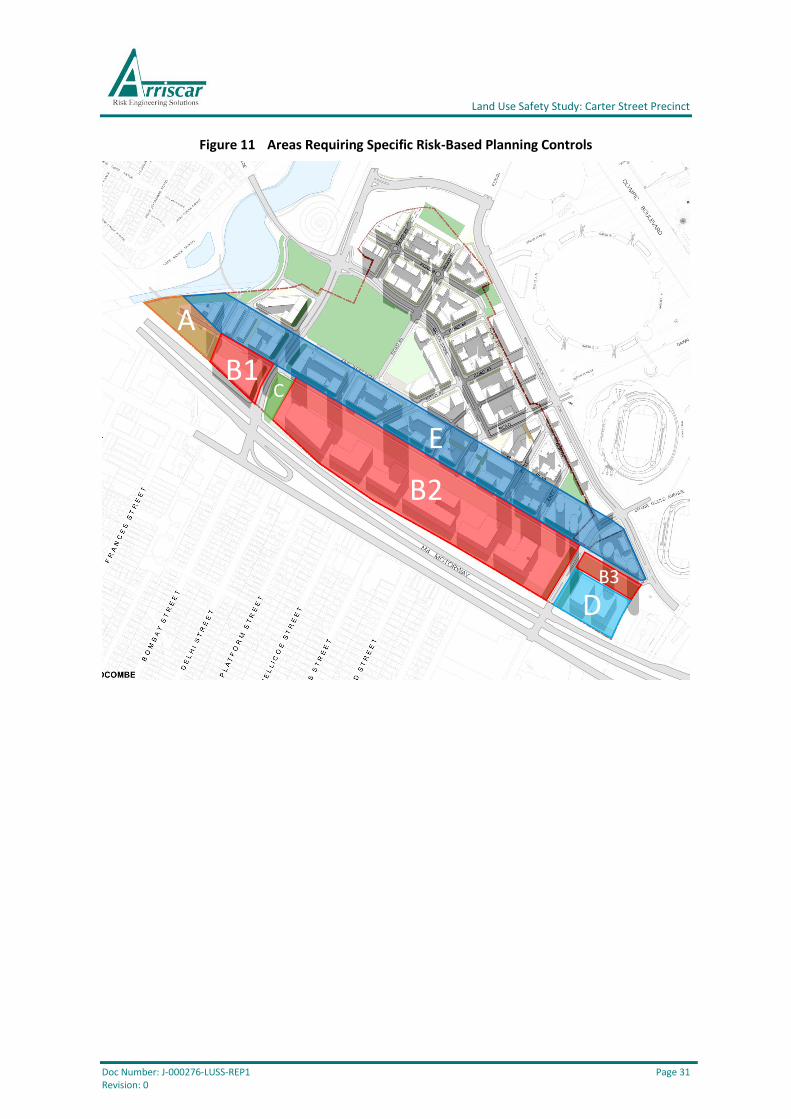
Within the Study Area, there are multiple areas where the combination of land use zoning and risk
warrants specific risk-based planning controls (Refer to Figure 11).
A summary table is included after Figure 11 for each specific area. The information in each table
provides a guide for land use safety planning throughout the Study Area. How this is achieved needs
to be determined by the DP&E as some of the proposed controls will only apply to the areas
identified in Figure 11 and should not be applied to all other similarly zoned areas defined within
the DCP. For example, sensitive use developments (e.g. child care centres) are currently ‘permitted
with consent’ in areas zoned B6 – Enterprise Corridor (Refer to Appendix A.2), however, this type of
development should be prohibited in Areas B and D (Lots CS 01, CS 02 and CS 03), despite its B6
zoning, since the cumulative risk from the existing pipelines exceeds the relevant DP&E risk criterion
for land use safety planning.
The current zoning is identified in each table for each area. Also, the proposed controls for future
developments (i.e. development near the existing potentially hazardous pipelines) are included,
together with the basis for each control.
The risk-based development controls shown in the summary tables are based on the magnitude of
the cumulative individual fatality risk and societal risk relative to the DP&E’s quantitative risk criteria
for land use safety planning (Refer to Section 3.3), as well as other relevant risk considerations.
Development applications should be reviewed on a case-by-case basis and should demonstrate
compliance with the DP&E’s qualitative and quantitative risk criteria, including, but not limited to,
cumulative societal risk.
The key points are as follows:
Individual Risk
• Future residential development should not be permitted within the extent of the 1 x 10⁻⁶
per year cumulative individual fatality risk contour (Refer to Figure 9). This restriction
applies to residential developments and places of continuous occupancy, such as hotels,
motels and tourist resorts (As per Section 2.4.2.1 of HIPAP No. 4).
• Sensitive uses should not be permitted within the extent of the 0.5 x 10⁻⁶ per year
cumulative individual fatality risk contour (Refer to Figure 9). This restriction applies to
sensitive uses such as hospitals, schools, child-care facilities and old age housing
development (As per Section 2.4.2.1 of HIPAP No. 4).
• Additional potentially hazardous pipelines should not be permitted unless the proponent
can demonstrate that the extent of the cumulative individual fatality risk contours will not
increase beyond the levels reported in Section 3.3.1 (Figure 9) and that all other cumulative
individual risks remain below the DP&E criteria for land use safety planning (Refer to
Sections 3.3.2-3.3.6).

Land Use Safety Study: Carter Street Precinct
Doc Number: J-000276-LUSS-REP1 Page 30 Revision: 0
Societal Risk
• For the area within the Enterprise Corridor (Areas B1, B2, and B3 on Figure 11) and the rest
of the precinct, population intensification beyond that considered in the QRA & LUSS (Refer
to Section 2.2) should only be permitted if the proponent can demonstrate that the societal
risk complies with the DP&E’s criteria (Note: A societal risk analysis is only required with the
Development Application if the proposed development would potentially increase the total
population for the applicable lot above the level assumed in this QRA & LUSS). This
potentially applies for the entire precinct; however, it is particularly relevant for areas A-E
on Figure 11.
• Additional potentially hazardous pipelines should not be permitted unless it can be
demonstrated that the magnitude of the societal risk will continue to comply with the
DP&E’s indicative societal risk criteria.
Other Risk Considerations
• The magnitude of the individual and societal risk is very dependent on the historically low
likelihood of major pipeline failures; however, the consequences if a failure were to occur
could be very severe. To comply with the DP&E’s qualitative risk criteria, it should be
ensured that building design and emergency response arrangements are commensurate
with the hazard posed by the potentially hazardous pipelines.
• Development should not be permitted near the pipeline easements. Therefore, future
development may not be practicable for Areas A and C and the part of Area B depending on
the location of the easements relative to the proposed development (Also refer to Figure
6). This might also apply for part of Area D, depending on the location of the easements
relative to the proposed development.
Land Use Safety Study: Carter Street Precinct
Doc Number: J-000276-LUSS-REP1 Page 31 Revision: 0
Figure 11 Areas Requiring Specific Risk-Based Planning Controls
A
B2
D
E
B1C
B3
Land Use Safety Study: Carter Street Precinct
Doc Number: J-000276-LUSS-REP1 Page 32 Revision: 0
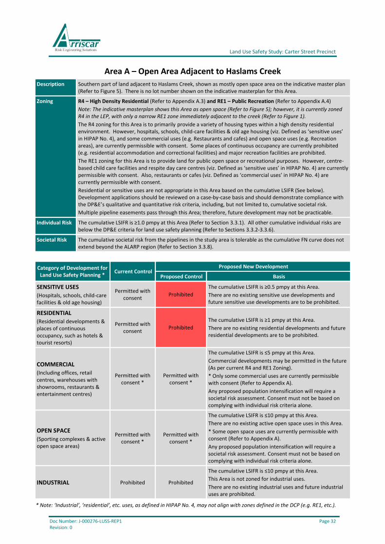
Area A – Open Area Adjacent to Haslams Creek
Description Southern part of land adjacent to Haslams Creek, shown as mostly open space area on the indicative master plan (Refer to Figure 5). There is no lot number shown on the indicative masterplan for this Area.
Zoning R4 – High Density Residential (Refer to Appendix A.3) and RE1 – Public Recreation (Refer to Appendix A.4)
Note: The indicative masterplan shows this Area as open space (Refer to Figure 5); however, it is currently zoned R4 in the LEP, with only a narrow RE1 zone immediately adjacent to the creek (Refer to Figure 1).
The R4 zoning for this Area is to primarily provide a variety of housing types within a high density residential environment. However, hospitals, schools, child-care facilities & old age housing (viz. Defined as ‘sensitive uses’ in HIPAP No. 4), and some commercial uses (e.g. Restaurants and cafes) and open space uses (e.g. Recreation areas), are currently permissible with consent. Some places of continuous occupancy are currently prohibited (e.g. residential accommodation and correctional facilities) and major recreation facilities are prohibited.
The RE1 zoning for this Area is to provide land for public open space or recreational purposes. However, centre-based child care facilities and respite day care centres (viz. Defined as ‘sensitive uses’ in HIPAP No. 4) are currently permissible with consent. Also, restaurants or cafes (viz. Defined as ‘commercial uses’ in HIPAP No. 4) are currently permissible with consent.
Residential or sensitive uses are not appropriate in this Area based on the cumulative LSIFR (See below). Development applications should be reviewed on a case-by-case basis and should demonstrate compliance with the DP&E’s qualitative and quantitative risk criteria, including, but not limited to, cumulative societal risk.
Multiple pipeline easements pass through this Area; therefore, future development may not be practicable.
Individual Risk The cumulative LSIFR is ≥1.0 pmpy at this Area (Refer to Section 3.3.1). All other cumulative individual risks are below the DP&E criteria for land use safety planning (Refer to Sections 3.3.2-3.3.6).
Societal Risk The cumulative societal risk from the pipelines in the study area is tolerable as the cumulative FN curve does not extend beyond the ALARP region (Refer to Section 3.3.8).
Category of Development for Land Use Safety Planning *
Current Control Proposed New Development
Proposed Control Basis
SENSITIVE USES
(Hospitals, schools, child-care facilities & old age housing)
Permitted with consent
Prohibited
The cumulative LSIFR is ≥0.5 pmpy at this Area.
There are no existing sensitive use developments and future sensitive use developments are to be prohibited.
RESIDENTIAL
(Residential developments & places of continuous occupancy, such as hotels & tourist resorts)
Permitted with consent
Prohibited
The cumulative LSIFR is ≥1 pmpy at this Area.
There are no existing residential developments and future residential developments are to be prohibited.
COMMERCIAL
(Including offices, retail centres, warehouses with showrooms, restaurants & entertainment centres)
Permitted with consent *
Permitted with consent *
The cumulative LSIFR is ≤5 pmpy at this Area.
Commercial developments may be permitted in the future (As per current R4 and RE1 Zoning).
* Only some commercial uses are currently permissible with consent (Refer to Appendix A).
Any proposed population intensification will require a societal risk assessment. Consent must not be based on complying with individual risk criteria alone.
OPEN SPACE
(Sporting complexes & active open space areas)
Permitted with consent *
Permitted with consent *
The cumulative LSIFR is ≤10 pmpy at this Area.
There are no existing active open space uses in this Area.
* Some open space uses are currently permissible with consent (Refer to Appendix A).
Any proposed population intensification will require a societal risk assessment. Consent must not be based on complying with individual risk criteria alone.
INDUSTRIAL Prohibited Prohibited
The cumulative LSIFR is ≤10 pmpy at this Area.
This Area is not zoned for industrial uses.
There are no existing industrial uses and future industrial uses are prohibited.
* Note: ‘Industrial’, ‘residential’, etc. uses, as defined in HIPAP No. 4, may not align with zones defined in the DCP (e.g. RE1, etc.).

Land Use Safety Study: Carter Street Precinct
Doc Number: J-000276-LUSS-REP1 Page 33 Revision: 0
Area B (B1, B2 and B3) – Enterprise Corridor
Description Lots CS 01, CS 02 and part of Lot CS 03 (Refer to Figure 5).
Zoning B6 – Enterprise Corridor (Refer to Appendix A.2)
The zoning for this Area is to primarily provide a range of employment uses (including business, office, retail and light industrial uses). However, hospitals, schools, child-care facilities & old age housing (viz. Defined as ‘sensitive uses’ in HIPAP No. 4) and residential developments & places of continuous occupancy, such as hotels & tourist resorts (viz. Defined as ‘residential uses’ in HIPAP No. 4) are currently permissible with consent. Also, some open space uses (e.g. Recreation areas) are currently permissible with consent. Some places of continuous occupancy are currently prohibited (e.g. Caravan parks and correctional facilities) and major recreation facilities are prohibited.
Residential or sensitive uses are not appropriate in this Area based on the cumulative LSIFR (See below). Development applications should be reviewed on a case-by-case basis and should demonstrate compliance with the DP&E’s qualitative and quantitative risk criteria, including, but not limited to, cumulative societal risk.
Individual Risk The cumulative LSIFR is ≥1.0 pmpy at this Area (Refer to Section 3.3.1). All other cumulative individual risks are below the DP&E criteria for land use safety planning (Refer to Sections 3.3.2-3.3.6).
Societal Risk The cumulative societal risk from the pipelines in the study area is tolerable as the cumulative FN curve does not extend beyond the ALARP region (Refer to Section 3.3.8).
Category of Development for Land Use Safety Planning *
Current Control Proposed New Development
Proposed Control Basis
SENSITIVE USES
(Hospitals, schools, child-care facilities & old age housing)
Permitted with consent
Prohibited
The cumulative LSIFR is ≥0.5 pmpy at this Area.
There are no existing sensitive use developments and future sensitive use developments are to be prohibited.
RESIDENTIAL
(Residential developments & places of continuous occupancy, such as hotels & tourist resorts)
Permitted with consent /
Prohibited * Prohibited
The cumulative LSIFR is ≥1 pmpy at this Area.
There are no existing residential developments and future residential developments are to be prohibited.
* Some places of continuous occupancy are currently permissible with consent and some are currently prohibited (Refer to Appendix A).
COMMERCIAL
(Including offices, retail centres, warehouses with showrooms, restaurants & entertainment centres)
Permitted with consent
Permitted with consent
The cumulative LSIFR is ≤5 pmpy at this Area.
There are existing commercial developments at this Area and these developments may be permitted in the future.
Any proposed population intensification will require a societal risk assessment. Consent must not be based on complying with individual risk criteria alone.
OPEN SPACE
(Sporting complexes & active open space areas)
Permitted with consent /
Prohibited *
Permitted with consent /
Prohibited *
The cumulative LSIFR is ≤10 pmpy at this Area.
There are no existing open space uses in this area; however, the indicative masterplan shows an open space area in Area B3.
* Some open space uses are currently permissible with consent and major recreation facilities are prohibited (Refer to Appendix A).
Any proposed population intensification will require a societal risk assessment. Consent must not be based on complying with individual risk criteria alone.
INDUSTRIAL Prohibited Prohibited
The cumulative LSIFR is ≤10 pmpy at this Area.
This Area is not zoned for industrial uses.
There are no existing industrial uses and future industrial uses are prohibited.
* Note: ‘Industrial’, ‘residential’, etc. uses, as defined in HIPAP No. 4, may not align with zones defined in the DCP (e.g. RE1, etc.).
Land Use Safety Study: Carter Street Precinct
Doc Number: J-000276-LUSS-REP1 Page 34 Revision: 0
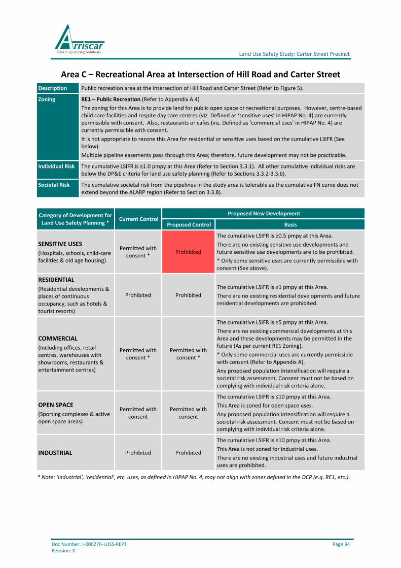
Area C – Recreational Area at Intersection of Hill Road and Carter Street
Description Public recreation area at the intersection of Hill Road and Carter Street (Refer to Figure 5).
Zoning RE1 – Public Recreation (Refer to Appendix A.4)
The zoning for this Area is to provide land for public open space or recreational purposes. However, centre-based child care facilities and respite day care centres (viz. Defined as ‘sensitive uses’ in HIPAP No. 4) are currently permissible with consent. Also, restaurants or cafes (viz. Defined as ‘commercial uses’ in HIPAP No. 4) are currently permissible with consent.
It is not appropriate to rezone this Area for residential or sensitive uses based on the cumulative LSIFR (See below).
Multiple pipeline easements pass through this Area; therefore, future development may not be practicable.
Individual Risk The cumulative LSIFR is ≥1.0 pmpy at this Area (Refer to Section 3.3.1). All other cumulative individual risks are below the DP&E criteria for land use safety planning (Refer to Sections 3.3.2-3.3.6).
Societal Risk The cumulative societal risk from the pipelines in the study area is tolerable as the cumulative FN curve does not extend beyond the ALARP region (Refer to Section 3.3.8).
Category of Development for Land Use Safety Planning *
Current Control Proposed New Development
Proposed Control Basis
SENSITIVE USES
(Hospitals, schools, child-care facilities & old age housing)
Permitted with consent *
Prohibited
The cumulative LSIFR is ≥0.5 pmpy at this Area.
There are no existing sensitive use developments and future sensitive use developments are to be prohibited.
* Only some sensitive uses are currently permissible with consent (See above).
RESIDENTIAL
(Residential developments & places of continuous occupancy, such as hotels & tourist resorts)
Prohibited Prohibited
The cumulative LSIFR is ≥1 pmpy at this Area.
There are no existing residential developments and future residential developments are prohibited.
COMMERCIAL
(Including offices, retail centres, warehouses with showrooms, restaurants & entertainment centres)
Permitted with consent *
Permitted with consent *
The cumulative LSIFR is ≤5 pmpy at this Area.
There are no existing commercial developments at this Area and these developments may be permitted in the future (As per current RE1 Zoning).
* Only some commercial uses are currently permissible with consent (Refer to Appendix A).
Any proposed population intensification will require a societal risk assessment. Consent must not be based on complying with individual risk criteria alone.
OPEN SPACE
(Sporting complexes & active open space areas)
Permitted with consent
Permitted with consent
The cumulative LSIFR is ≤10 pmpy at this Area.
This Area is zoned for open space uses.
Any proposed population intensification will require a societal risk assessment. Consent must not be based on complying with individual risk criteria alone.
INDUSTRIAL Prohibited Prohibited
The cumulative LSIFR is ≤10 pmpy at this Area.
This Area is not zoned for industrial uses.
There are no existing industrial uses and future industrial uses are prohibited.
* Note: ‘Industrial’, ‘residential’, etc. uses, as defined in HIPAP No. 4, may not align with zones defined in the DCP (e.g. RE1, etc.).

Land Use Safety Study: Carter Street Precinct
Doc Number: J-000276-LUSS-REP1 Page 35 Revision: 0
Area D – Enterprise Corridor (East of Birnie Avenue)
Description Part of Lot CS 03 to the south of Carter Street (Refer to Figure 5).
Zoning B6 – Enterprise Corridor (Refer to Appendix A.2)
The zoning for this Area is to primarily provide a range of employment uses (including business, office, retail and light industrial uses). However, hospitals, schools, child-care facilities & old age housing (viz. Defined as ‘sensitive uses’ in HIPAP No. 4) and residential developments & places of continuous occupancy, such as hotels & tourist resorts (viz. Defined as ‘residential uses’ in HIPAP No. 4) are currently permissible with consent. Also, some open space uses (e.g. Recreation areas) are currently permissible with consent. Some places of continuous occupancy are currently prohibited (e.g. Caravan parks and correctional facilities) and major recreation facilities are prohibited.
Sensitive uses are not appropriate in this Area based on the cumulative LSIFR (See below). Rezoning of this Area for residential uses may be appropriate based on the cumulative LSIFR; however, this would be contingent on compliance with the societal risk criteria (See below). Development applications should be reviewed on a case-by-case basis and should demonstrate compliance with the DP&E’s qualitative and quantitative risk criteria, including, but not limited to, cumulative societal risk.
Individual Risk The cumulative LSIFR is ≥1.0 pmpy at this Area (Refer to Section 3.3.1). All other cumulative individual risks are below the DP&E criteria for land use safety planning (Refer to Sections 3.3.2-3.3.6).
Societal Risk The cumulative societal risk from the pipelines in the study area is tolerable as the cumulative FN curve does not extend beyond the ALARP region (Refer to Section 3.3.8).
Category of Development for Land Use Safety Planning *
Current Control Proposed New Development
Proposed Control Basis
SENSITIVE USES
(Hospitals, schools, child-care facilities & old age housing)
Permitted with consent
Prohibited
The cumulative LSIFR is ≥0.5 pmpy at this Area.
There are no existing sensitive use developments and future sensitive use developments are to be prohibited.
RESIDENTIAL
(Residential developments & places of continuous occupancy, such as hotels & tourist resorts)
Permitted with consent /
Prohibited *
Permitted with consent /
Prohibited *
The cumulative LSIFR is ≤1 pmpy at this Area.
There are no existing residential developments and future residential developments may be permitted in the future.
* Some places of continuous occupancy are currently permissible with consent and some are currently prohibited (Refer to Appendix A).
Any proposed population intensification will require a societal risk assessment. Consent must not be based on complying with individual risk criteria alone.
COMMERCIAL
(Including offices, retail centres, warehouses with showrooms, restaurants & entertainment centres)
Permitted with consent
Permitted with consent
The cumulative LSIFR is ≤5 pmpy at this Area.
There are existing commercial developments at this Area and these developments may be permitted in the future.
Any proposed population intensification will require a societal risk assessment. Consent must not be based on complying with individual risk criteria alone.
OPEN SPACE
(Sporting complexes & active open space areas)
Permitted with consent /
Prohibited *
Permitted with consent /
Prohibited *
The cumulative LSIFR is ≤10 pmpy at this Area.
There are no existing open space uses in this area.
* Some open space uses are currently permissible with consent and major recreation facilities are prohibited (Refer to Appendix A).
Any proposed population intensification will require a societal risk assessment. Consent must not be based on complying with individual risk criteria alone.
INDUSTRIAL Prohibited Prohibited
The cumulative LSIFR is ≤10 pmpy at this Area.
This Area is not zoned for industrial uses.
There are no existing industrial uses and future industrial uses are prohibited.
* Note: ‘Industrial’, ‘residential’, etc. uses, as defined in HIPAP No. 4, may not align with zones defined in the DCP (e.g. RE1, etc.).
Land Use Safety Study: Carter Street Precinct
Doc Number: J-000276-LUSS-REP1 Page 36 Revision: 0
Area E – Residential Areas Fronting Carter Street
Description Residential areas fronting Carter Street (Northern side) through to Haslams Creek. This includes Lots HC 03, P 01, P 02, TC 04, TC 07, TC 08, TC 10, CSN 03, CSN 04 and CSN 05 (Refer to Figure 5).
Includes northern part of land adjacent to Haslams Creek, shown as an open space area on the indicative master plan (Refer to Figure 5). There is no lot number shown on the indicative masterplan for this Area.
Zoning B2 – Local Centre (Refer to Appendix A.1), R4 – High Density Residential (Refer to Appendix A.3) and RE1 – Public Recreation (Refer to Appendix A.4)
Note: The indicative masterplan shows the northern part of land adjacent to Haslams Creek as open space (Refer to Figure 5); however, it is currently zoned R4 in the LEP, with only a narrow RE1 zone immediately adjacent to the creek (Refer to Figure 1).
The zoning for this Area is predominantly for high density residential uses and commercial uses (e.g. retail, business, entertainment and community uses). However, some sensitive uses (viz. As defined in HIPAP No. 4) are currently permissible with consent in all three zones (Refer to Appendix A).
Sensitive uses are not appropriate in this Area based on the cumulative LSIFR (See below). Development applications should be reviewed on a case-by-case basis and should demonstrate compliance with the DP&E’s qualitative and quantitative risk criteria, including, but not limited to, cumulative societal risk.
Individual Risk The cumulative LSIFR is ≥0.5 pmpy at this Area (Refer to Section 3.3.1). All other cumulative individual risks are below the DP&E criteria for land use safety planning (Refer to Sections 3.3.2-3.3.6).
Societal Risk The cumulative societal risk from the pipelines in the study area is tolerable as the cumulative FN curve does not extend beyond the ALARP region (Refer to Section 3.3.8).
Category of Development for Land Use Safety Planning *
Current Control Proposed New Development
Proposed Control Basis
SENSITIVE USES
(Hospitals, schools, child-care facilities & old age housing)
Permitted with consent
Prohibited
The cumulative LSIFR is ≥0.5 pmpy at this Area.
There are no existing sensitive use developments and future sensitive use developments are to be prohibited.
RESIDENTIAL
(Residential developments & places of continuous occupancy, such as hotels & tourist resorts)
Permitted with consent /
Prohibited *
Permitted with consent /
Prohibited *
The cumulative LSIFR is ≤1 pmpy at this Area.
Residential developments may be permitted in the future.
* Some places of continuous occupancy are currently permissible with consent and some are currently prohibited (Refer to Appendix A).
Any proposed population intensification will require a societal risk assessment. Consent must not be based on complying with individual risk criteria alone.
COMMERCIAL
(Including offices, retail centres, warehouses with showrooms, restaurants & entertainment centres)
Permitted with consent
Permitted with consent
The cumulative LSIFR is ≤5 pmpy at this Area.
There are existing commercial developments at this Area and these developments may be permitted in the future.
Any proposed population intensification will require a societal risk assessment. Consent must not be based on complying with individual risk criteria alone.
OPEN SPACE
(Sporting complexes & active open space areas)
Permitted with consent /
Prohibited *
Permitted with consent /
Prohibited *
The cumulative LSIFR is ≤10 pmpy at this Area.
There are no existing active open space uses in this Area.
* Some open space uses are currently permissible with consent (Refer to Appendix A). Major recreation facilities are prohibited for Zone R4 (Refer to Appendix A).
Any proposed population intensification will require a societal risk assessment. Consent must not be based on complying with individual risk criteria alone.
INDUSTRIAL Prohibited Prohibited
The cumulative LSIFR is ≤10 pmpy at this Area.
This Area is not zoned for industrial uses.
There are no existing industrial uses and future industrial uses are prohibited.
* Note: ‘Industrial’, ‘residential’, etc. uses, as defined in HIPAP No. 4, may not align with zones defined in the DCP (e.g. RE1, etc.).
Land Use Safety Study: Carter Street Precinct
Doc Number: J-000276-LUSS-REP1 Page 37 Revision: 0
5 PLANNING PROPOSALS
5.1 Introduction
Three Planning Proposals (PPs) are applicable for the Study Area:
• Meriton Group’s Urban Design Report for 1-13 Carter Street and 23 Uhrig Road, which was
prepared by SJB Architects and issued 19 July 2017 (PP No. 1);
• AYMCI’s Submission to DPE / master plan review for Carter Street, which was prepared by
Architectus and issued 23 January 2017 (PP No. 2); and
• SLA’s Urban Design Analysis and Masterplan Concept for 12-14 Birnie Avenue, which was
prepared by SJB Architects and issued 19 May 2017 (PP No. 3).
PP No. 1 and PP No. 3 both acknowledge the presence of pipeline easements in the Study Area.
However, the potential risks from the potentially hazardous pipelines do not appear to have been
considered in the PPs.
Some of the PPs show the light rail continuing along Uhrig Road and potentially onto Carter Street.
However, the indicative masterplan now has the light rail terminating before reaching Carter Street
(Refer to Section 2.2), which limits the potential for interaction with the pipelines.
Key points from the PPs that are relevant to the LUSS are discussed in Sections 5.2 - 5.4.
5.2 Meriton Group’s Urban Design Report for 1-13 Carter Street and 23 Uhrig Road
Development across the Meriton Group’s site is divided into four phases of design and construction
(Refer to Figure 12). Construction of the Phase 1 development is currently underway, and a DA has
been submitted for Phase 2. Phases 3 and 4 are future development phases.
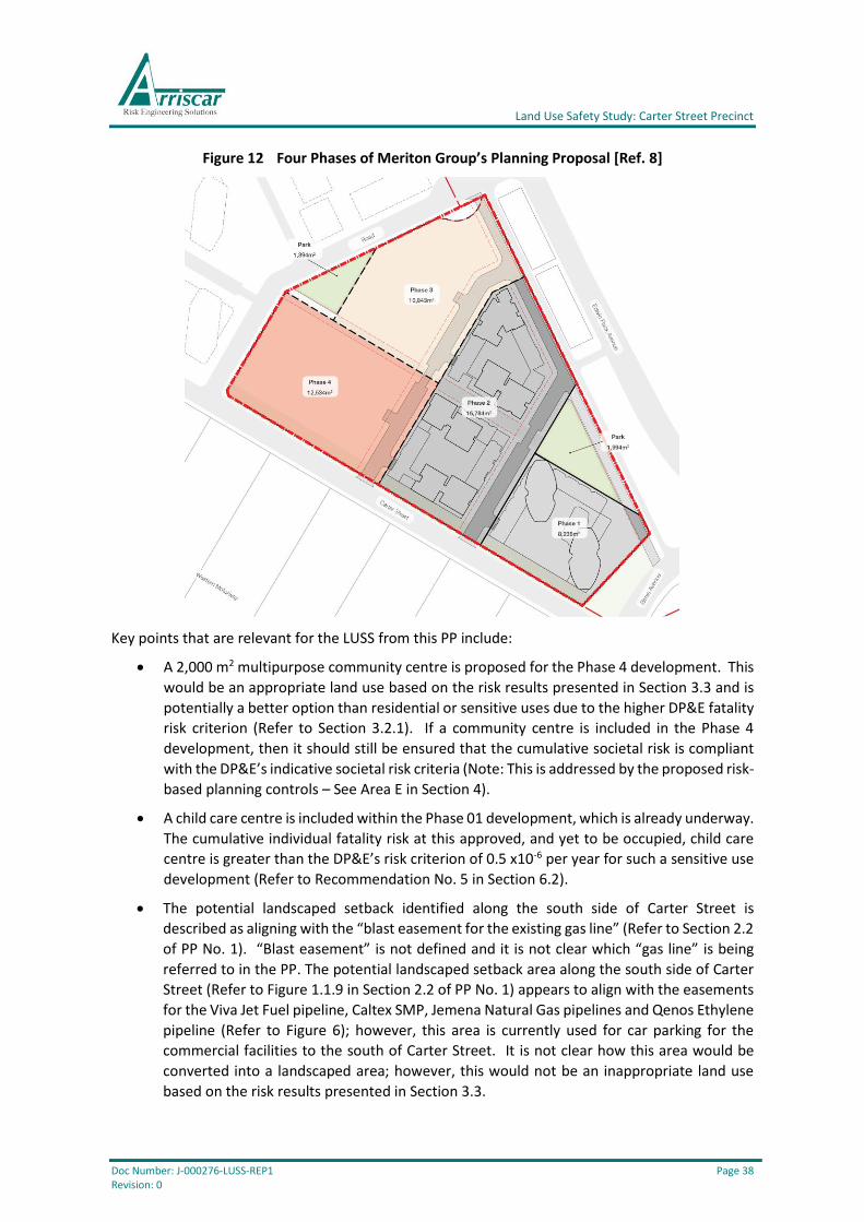
Land Use Safety Study: Carter Street Precinct
Doc Number: J-000276-LUSS-REP1 Page 38 Revision: 0
Figure 12 Four Phases of Meriton Group’s Planning Proposal [Ref. 8]
Key points that are relevant for the LUSS from this PP include:
• A 2,000 m2 multipurpose community centre is proposed for the Phase 4 development. This
would be an appropriate land use based on the risk results presented in Section 3.3 and is
potentially a better option than residential or sensitive uses due to the higher DP&E fatality
risk criterion (Refer to Section 3.2.1). If a community centre is included in the Phase 4
development, then it should still be ensured that the cumulative societal risk is compliant
with the DP&E’s indicative societal risk criteria (Note: This is addressed by the proposed risk-
based planning controls – See Area E in Section 4).
• A child care centre is included within the Phase 01 development, which is already underway.
The cumulative individual fatality risk at this approved, and yet to be occupied, child care
centre is greater than the DP&E’s risk criterion of 0.5 x10⁻⁶ per year for such a sensitive use
development (Refer to Recommendation No. 5 in Section 6.2).
• The potential landscaped setback identified along the south side of Carter Street is
described as aligning with the “blast easement for the existing gas line” (Refer to Section 2.2
of PP No. 1). “Blast easement” is not defined and it is not clear which “gas line” is being
referred to in the PP. The potential landscaped setback area along the south side of Carter
Street (Refer to Figure 1.1.9 in Section 2.2 of PP No. 1) appears to align with the easements
for the Viva Jet Fuel pipeline, Caltex SMP, Jemena Natural Gas pipelines and Qenos Ethylene
pipeline (Refer to Figure 6); however, this area is currently used for car parking for the
commercial facilities to the south of Carter Street. It is not clear how this area would be
converted into a landscaped area; however, this would not be an inappropriate land use
based on the risk results presented in Section 3.3.

Land Use Safety Study: Carter Street Precinct
Doc Number: J-000276-LUSS-REP1 Page 39 Revision: 0
• A landscaped setback of about 10 m is identified along the north side of Carter Street (Refer
to Figure 1.1.9 in Section 2.2 of PP No. 1), which is consistent with the setback specified in
the 2016 DCP [Ref. 2]. This is an appropriate setback based on the risk results presented in
Section 3.3 (Particularly Section 3.3.1).
• Parking will be above ground, with parking levels in the podium levels screened by
apartments (Refer to Section 3.4 of PP No. 1). Above ground parking reduces the need for
excavation and will limit underground areas where gas / liquid / vapour could accumulate
(Refer to Recommendation No. 9 in Section 6.2). Inclusion of parking levels in the podium
levels, rather than other permanently occupied uses, will potentially reduce the likelihood
of exposure from an incident involving the pipelines and is therefore consistent with the
DP&E’s qualitative risk criteria (Refer to Section 3.2.5). The likelihood of exposure could be
further reduced if the car parking levels were not screened by apartments along the side of
the building facing Carter Street.
• Communal open spaces are shown on the top of the podium levels (Refer to Section 3.4 of
PP No. 1). These are an appropriate land use based on the risk results presented in Section
3.3.
5.3 AYMCI’s Submission to DPE / Master Plan Review
AYMCI are the largest land-owner in the Precinct, as shown on Figure 13.
Figure 13 Site of AYMCI’s Planning Proposal [Ref. 1]
Key points that are relevant for the LUSS from this PP include:
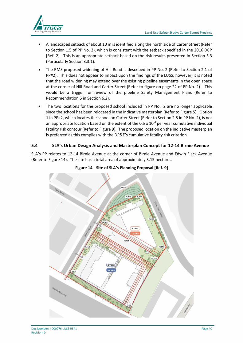
Land Use Safety Study: Carter Street Precinct
Doc Number: J-000276-LUSS-REP1 Page 40 Revision: 0
• A landscaped setback of about 10 m is identified along the north side of Carter Street (Refer
to Section 1.5 of PP No. 2), which is consistent with the setback specified in the 2016 DCP
[Ref. 2]. This is an appropriate setback based on the risk results presented in Section 3.3
(Particularly Section 3.3.1).
• The RMS proposed widening of Hill Road is described in PP No. 2 (Refer to Section 2.1 of
PP#2). This does not appear to impact upon the findings of the LUSS; however, it is noted
that the road widening may extend over the existing pipeline easements in the open space
at the corner of Hill Road and Carter Street (Refer to figure on page 22 of PP No. 2). This
would be a trigger for review of the pipeline Safety Management Plans (Refer to
Recommendation 6 in Section 6.2).
• The two locations for the proposed school included in PP No. 2 are no longer applicable
since the school has been relocated in the indicative masterplan (Refer to Figure 5). Option
1 in PP#2, which locates the school on Carter Street (Refer to Section 2.5 in PP No. 2), is not
an appropriate location based on the extent of the 0.5 x 10⁻⁶ per year cumulative individual
fatality risk contour (Refer to Figure 9). The proposed location on the indicative masterplan
is preferred as this complies with the DP&E’s cumulative fatality risk criterion.
5.4 SLA’s Urban Design Analysis and Masterplan Concept for 12-14 Birnie Avenue
SLA’s PP relates to 12-14 Birnie Avenue at the corner of Birnie Avenue and Edwin Flack Avenue
(Refer to Figure 14). The site has a total area of approximately 3.15 hectares.
Figure 14 Site of SLA’s Planning Proposal [Ref. 9]
Land Use Safety Study: Carter Street Precinct
Doc Number: J-000276-LUSS-REP1 Page 41 Revision: 0
Key points that are relevant for the LUSS from this PP include:
• As with PP No. 1, a landscaped setback area is shown along the south side of Carter Street
(Refer to Figure 2.2.1 in Section 2.2 of PP No. 3) appears to align with the easements for the
Viva Jet Fuel pipeline, Caltex SMP, Jemena Natural Gas pipelines and Qenos Ethylene
pipeline (Refer to Figure 6); however, this area is currently used for car parking for the
commercial facilities to the south of Carter Street. It is not clear how this area would be
converted into a landscaped area (unless the commercial facilities were relocated – see
below); however, this would not be an inappropriate land use based on the risk results
presented in Section 3.3.
• It is reported in Section 2.3 of PP No. 3 that there “may be an opportunity in the long-term
future to rezone commercial uses adjacent to the Western Motorway” and the “future
rezoning of this commercial zone area into mixed-use or residential uses may provide the
opportunity for the provision of a secondary green spine within the Carter Street frontage
setback”. This may be credible based on the extent of the 1.0 x 10⁻⁶ per year cumulative
fatality risk contour (Refer to Figure 9); however, the societal risk could exceed the DP&E’s
indicative societal risk criteria if significant population intensification occurs (Refer to Figure
10).
• It is reported in Section 2.4 of PP No. 3 that a “significant portion of the site comprises
easements with multiple ownerships. These restricted areas have been taken into account
and have helped to form the parameters for the Urban Design and masterplanning process”.
These easements are shown as dotted lines on Figure 14. It is not clear how these restricted
areas have been taken into account other than by locating open space areas above the
easements (i.e. not locating buildings on the easements).
• Two options are presented in Section 4.1 of PP No. 3:
o Option 1 retains the existing commercial uses at the southern end of the site (as per
current B6 Enterprise Corridor zoning), with high density residential at the northern
end (as per current R4 High Density Residential zoning). The existing easement area
is open space.
o Option 2 proposes rezoning the southern portion of the site from B6 Enterprise
Corridor to R4 High Density Residential. The proposed open space for the existing
easements would remain as in Option 1.
Both options are credible based on the extent of the 1.0 x 10⁻⁶ per year cumulative fatality
risk contour (Refer to Figure 9); however, the societal risk could exceed the DP&E’s
indicative societal risk criteria if significant population intensification occurs under option 2
(Refer to Figure 10) and sensitive uses would not be appropriate for either option based on
the extent of the 0.5 x 10⁻⁶ per year cumulative fatality risk contour (Refer to Figure 9).
It is also noted that Option 2 would result in multiple easements on two sides of the
residential buildings on the southern portion of the site. This would place these residential
buildings closer to more potentially hazardous pipelines than any other residential building
in the precinct. This may not comply with the DP&E’s qualitative risk criteria, particularly as
Option 2 would require rezoning.
Other uses that are already permissible for the B6 Enterprise Corridor (e.g. hotel / motel
accommodation) may be more appropriate than residential developments; however, this
would still be contingent on demonstrating compliance with the DP&E’s indicative societal
risk criteria (also refer to Area D in Section 4).
Land Use Safety Study: Carter Street Precinct
Doc Number: J-000276-LUSS-REP1 Page 42 Revision: 0
Land Use Safety Study: Carter Street Precinct
Doc Number: J-000276-LUSS-REP1 Page 43 Revision: 0
6 FINDINGS AND RECOMMENDATIONS
6.1 Findings
6.1.1 Risk Assessment
Most of the proposed land uses in the current indicative masterplan, LEP and DCP comply with the
DP&E’s individual risk criteria for land use safety planning. However, future sensitive use
development should not be permitted within the extent of the 0.5 x 10⁻⁶ per year cumulative
individual fatality risk contour and future residential development should not be permitted within
the extent of the 1 x 10⁻⁶ per year cumulative individual fatality risk contour (Refer to Figure 9).
There are no existing sensitive use developments within the 0.5 x 10⁻⁶ per year fatality risk contour
other than an approved, and yet to be occupied, child care centre near the intersection of Carter
Street and Birnie Road (Refer to Figure 9). The consent authority should resolve this existing land
use safety conflict by adopting the principles outlined in Section 4.2.4 of HIPAP No. 10. This might,
for example, include relocating the child care centre further away from the pipelines and/or
implementing other risk mitigation measures (e.g. safe refuge facilities) to protect the occupants.
There are no existing residential developments within the 1.0 x 10⁻⁶ per year fatality risk contour;
however, construction of an approved high-rise residential building has commenced at the
intersection of Carter Street and Birnie Road.
The cumulative individual fatality risk marginally exceeds the relevant DP&E criterion for residential
land uses at the proposed residential lot boundaries along the southern edge of Area E (Refer to
Figure 9 and Figure 11). However, the cumulative fatality risk is less than the relevant DP&E criterion
for most of the lot areas, particularly where residences are likely to be located. In accordance with
Section 2.1.4 of HIPAP No. 4, the residential developments along the southern edge of Area E are
considered acceptable.
The societal risk from the pipelines in the study area is tolerable as the cumulative FN curve does
not extend beyond the ALARP region (Also refer to Section 3.2.4). However, it is relatively close to
the upper ‘intolerable’ criterion line and further population intensification may not be appropriate.
Population intensification beyond that considered in the QRA & LUSS (Refer to Section 2.3) should
only be permitted if the proponent can demonstrate that the societal risk complies with the DP&E’s
criteria (Note: A societal risk analysis is only required with the Development Application if the
proposed development would potentially increase the total population for the applicable lot above
the level assumed in this QRA & LUSS). This potentially applies for the entire precinct; however, it
is particularly relevant for areas A-E on Figure 11.
6.1.2 Planning Proposals
The three planning proposals (refer to Section 5) are generally consistent with the indicative
masterplan and outline land uses that are generally appropriate based on the DP&E’s risk criteria
for land use safety planning.
The planning proposals include some measures that may reduce risk exposure, such as the 10 metre
setback along the north side of Carter Street (which is consistent with the setback specified in the
2016 DCP [Ref. 2]) and locating car parks above ground in the podium levels (Refer to Section 5.2).
The proposed location of the school on the indicative masterplan is preferred as this complies with
the DP&E’s cumulative fatality risk criterion.
Land Use Safety Study: Carter Street Precinct
Doc Number: J-000276-LUSS-REP1 Page 44 Revision: 0
Widening of Hill Road (as described in PP No. 2) may extend over the existing pipeline easements in
the open space at the corner of Hill Road and Carter Street (Refer to figure on page 22 of PP No. 2).
This would be a trigger for review of the pipeline Safety Management Plans (Refer to
Recommendation 6 in Section 6.2).
6.1.3 Risk-Based Development Controls
Within the Study Area, there are several areas where the combination of land use zoning and risk
warrants specific risk-based planning controls (Refer to Figure 11).
The risk-based development controls proposed in Section 4 are based on the magnitude of the
cumulative individual fatality risk and societal risk relative to the DP&E’s quantitative risk criteria for
land use safety planning (Refer to Section 3.3), as well as other relevant risk considerations (e.g.
locations of pipeline easements).
6.2 Recommendations
Recommendations for each relevant stakeholder are listed below.
Planning Authority
1. The planning authority should implement the proposed risk-based planning controls, as
outlined in Section 4, as soon as practicable. Exactly how this is achieved will need to be
determined by the planning authority as some of the proposed controls will only apply to
some parts of the Study Area and should not be applied to all other similarly zoned areas
defined within the current LEP and DCP.
In particular, population intensification beyond that considered in the QRA & LUSS (Refer
to Section 2.3) should only be permitted if the proponent can demonstrate that the
societal risk complies with the DP&E’s criteria published in HIPAP No. 10. Development
applications and planning proposals for rezoning should only be permitted if the risks
comply with the relevant risk criteria for strategic land use safety planning published in
HIPAP No. 10 (including, but not limited to, the DP&E’s qualitative risk and societal risk
criteria).
2. The locations of the pipeline easements (including above and below ground pipework) in
the Study Area should be surveyed and marked on an appropriate plan (and/or electronic
GIS system) for inclusion in the next revision of the LEP and DCP.
Consent Authority
3. The consent authority should implement the amended LEP and DCP incorporating the
proposed risk-based planning controls, as outlined in Recommendation No. 1, as soon as
practicable.
4. The consent authority should ensure that the information required to be submitted by
Proponents in the Study Area (as per Recommendations 7 to 10) is received and assessed
accordingly.
Land Use Safety Study: Carter Street Precinct
Doc Number: J-000276-LUSS-REP1 Page 45 Revision: 0
5. An approved, and yet to be occupied, child care centre is located near the intersection of
Carter Street and Birnie Road. The cumulative fatality risk at this location is greater than
the DP&E’s criterion for new sensitive use developments (Refer to Figure 9) and the
consent authority should resolve this land use safety conflict by adopting the principles
outlined in Section 4.2.4 of HIPAP No. 10. This might, for example, include relocating the
child care centre further away from the pipelines (e.g. to the northern side of the lot)
and/or implementing other risk mitigation measures (e.g. safe refuge facilities) to protect
the occupants.
Pipeline Operators
6. Each pipeline operator should progressively review and update the Safety Management
Study and Emergency Response Plan for each pipeline in the Study Area (as per Section 11
of AS 2885.3:2012). This should be undertaken as redevelopment progressively occurs
throughout the Study Area (Particularly in Areas A-E – Refer to Figure 11). The reviews
should consider all safety aspects for these pipelines (e.g. including prevention and
mitigation of escalation to adjacent pipelines; detection and isolation measures if a leak
occurs; how to prevent damage to the pipelines during the future construction activities,
etc.).
Proponents for Future Development
7. Proponents should demonstrate that appropriate consultation has occurred with the
pipeline operators. Consultation should occur as soon as is practicable, with the primary
aim to ensure that the potential impacts of the development on the existing potentially
hazardous pipelines (and vice-versa) are clearly understood and will be appropriately
managed (also refer to Recommendations 8 to 10).
8. It should be ensured that construction activities in the Study Area (Particularly in Areas A-
E – Refer to Figure 11) do not impact upon the existing potentially hazardous pipelines.
The proponent should demonstrate how this will be achieved.
9. New, or modified, occupied buildings in Areas A-E (Refer to Figure 11) should be
constructed with due regard of the fire and explosion hazards posed by the pipelines. The
proponent should demonstrate how protection of the building occupants has been
incorporated into the building design (e.g. through use of appropriate non-combustible
materials (cladding etc.), fire-rated walls, sizing and location of windows and balconies,
measures to minimise smoke ingress, use of impermeable barriers to prevent ingress of
gas / liquid / vapour into underground basements / car parks, etc.).
10. Emergency refuge and/or egress arrangements should be provided for all new, or
modified, buildings in Areas A-E (Refer to Figure 11). This is to ensure the safety of building
occupants in the event of an incident involving a pipeline. The proponent should
demonstrate how this has been incorporated into the building design (e.g. through the
use of fire rated emergency egress stairwells, egress to a safe location on the far side of
the building away from the pipelines, shelter-in-place facilities, etc.) and should prepare
appropriate emergency response plan/s for use by the building occupants.
Land Use Safety Study: Carter Street Precinct
Doc Number: J-000276-LUSS-REP1 Page 46 Revision: 0
7 REFERENCES
1. Architectus, 23 January 2017, Submission to DPE / master plan review.
2. Department of Planning and Environment, 13 January 2016, Carter Street Precinct,
Development Control Plan 2016.
3. Department of Planning and Environment, August 2017, Carter Street Precinct, Preparation
of Hazards and Risks Assessment, Consultancy Scope of Works, PROC-2000651.
4. Department of Planning and Infrastructure, January 2011, HIPAP 4: Risk Criteria for Land
Use Safety Planning.
5. Department of Planning and Infrastructure, January 2011, HIPAP 10: Land Use Safety
Planning.
6. e8urban, May 2018, Indicative Masterplan.
7. NSW Government, Auburn Local Environmental Plan 2010.
8. SJB Architects, 19 July 2017, Urban Design Report for 1-13 Carter Street and 23 Uhrig Road.
9. SJB Architects, 19 May 2017, Urban Design Analysis and Masterplan Concept for 12-14 Birnie
Avenue.
10. Standards Australia, AS 2885.1—2012, Pipelines—Gas and liquid petroleum, Part 1: Design
and construction.
11. Standards Australia, AS 2885.3—2012, Pipelines—Gas and liquid petroleum, Part 3:
Operation and maintenance.

Land Use Safety Study: Carter Street Precinct
Doc Number: J-000276-LUSS-REP1 Page 47 Revision: 0
Appendices

Land Use Safety Study: Carter Street Precinct
Doc Number: J-000276-LUSS-REP1 Page 48 Revision: 0
Appendix A Land Use Zones from Auburn LEP
A.1 Zone B2 Local Centre
1 Objectives of zone
• To provide a range of retail, business, entertainment and community uses that serve the
needs of people who live in, work in and visit the local area.
• To encourage employment opportunities in accessible locations.
• To maximise public transport patronage and encourage walking and cycling.
• To encourage high density residential development.
• To encourage appropriate businesses that contribute to economic growth.
• To achieve an accessible, attractive and safe public domain.
2 Permitted without consent
Nil
3 Permitted with consent
Boarding houses; Centre-based child care facilities; Commercial premises; Community facilities;
Educational establishments; Entertainment facilities; Function centres; Group homes; Information
and education facilities; Medical centres; Passenger transport facilities; Recreation facilities
(indoor); Registered clubs; Residential flat buildings; Respite day care centres; Restricted premises;
Roads; Self-storage units; Service stations; Serviced apartments; Shop top housing; Tourist and
visitor accommodation; Warehouse or distribution centres; Any other development not specified in
item 2 or 4
4 Prohibited
Agriculture; Air transport facilities; Animal boarding or training establishments; Boat building and
repair facilities; Boat sheds; Camping grounds; Caravan parks; Cemeteries; Charter and tourism
boating facilities; Correctional centres; Crematoria; Depots; Eco-tourist facilities; Electricity
generating works; Environmental facilities; Exhibition homes; Exhibition villages; Extractive
industries; Farm buildings; Forestry; Freight transport facilities; Heavy industrial storage
establishments; Highway service centres; Home occupations (sex services); Industrial retail outlets;
Industrial training facilities; Industries; Marinas; Mooring pens; Moorings; Open cut mining; Port
facilities; Recreation facilities (major); Research stations; Residential accommodation; Rural
industries; Sewerage systems; Sex services premises; Storage premises; Transport depots; Waste or
resource management facilities; Water recreation structures; Water supply systems; Wharf or
boating facilities; Wholesale supplies
A.2 Zone B6 Enterprise Corridor
1 Objectives of zone
• To promote businesses along main roads and to encourage a mix of compatible uses.
• To provide a range of employment uses (including business, office, retail and light industrial
uses).
• To maintain the economic strength of centres by limiting retailing activity.

Land Use Safety Study: Carter Street Precinct
Doc Number: J-000276-LUSS-REP1 Page 49 Revision: 0
2 Permitted without consent
Nil
3 Permitted with consent
Building identification signs; Bulky goods premises; Business identification signs; Business premises;
Community facilities; Food and drink premises; Garden centres; Hardware and building supplies;
Hotel or motel accommodation; Kiosks; Landscaping material supplies; Light industries; Markets;
Neighbourhood shops; Passenger transport facilities; Plant nurseries; Roads; Timber yards; Vehicle
sales or hire premises; Warehouse or distribution centres; Any other development not specified in
item 2 or 4
4 Prohibited
Agriculture; Air transport facilities; Animal boarding or training establishments; Boat building and
repair facilities; Boat sheds; Camping grounds; Caravan parks; Cemeteries; Charter and tourism
boating facilities; Correctional centres; Crematoria; Eco-tourist facilities; Electricity generating
works; Environmental facilities; Exhibition homes; Exhibition villages; Extractive industries; Farm
buildings; Forestry; Heavy industrial storage establishments; Highway service centres; Home
occupations (sex services); Industrial training facilities; Industries; Marinas; Mooring pens;
Moorings; Open cut mining; Port facilities; Recreation facilities (major); Research stations;
Residential accommodation; Restricted premises; Retail premises; Rural industries; Sewerage
systems; Sex services premises; Signage; Tourist and visitor accommodation; Waste or resource
management facilities; Water recreation structures; Water supply systems; Wharf or boating
facilities
A.3 Zone R4 High Density Residential
1 Objectives of zone
• To provide for the housing needs of the community within a high density residential
environment.
• To provide a variety of housing types within a high density residential environment.
• To enable other land uses that provide facilities or services to meet the day to day needs of
residents.
• To encourage high density residential development in close proximity to bus service nodes
and railway stations.
2 Permitted without consent
Nil
3 Permitted with consent
Attached dwellings; Bed and breakfast accommodation; Boarding houses; Building identification signs; Business identification signs; Centre-based child care facilities; Community facilities; Hostels; Hotel or motel accommodation; Multi dwelling housing; Neighbourhood shops; Places of public worship; Residential flat buildings; Respite day care centres; Roads; Semi-detached dwellings; Shop top housing; Any other development not specified in item 2 or 4
4 Prohibited
Agriculture; Air transport facilities; Amusement centres; Animal boarding or training establishments; Boat building and repair facilities; Boat sheds; Camping grounds; Car parks; Caravan parks; Cemeteries; Charter and tourism boating facilities; Commercial premises; Correctional centres; Crematoria; Depots; Eco-tourist facilities; Electricity generating works; Entertainment

Land Use Safety Study: Carter Street Precinct
Doc Number: J-000276-LUSS-REP1 Page 50 Revision: 0
facilities; Environmental facilities; Exhibition homes; Exhibition villages; Extractive industries; Farm buildings; Forestry; Freight transport facilities; Function centres; Heavy industrial storage establishments; Highway service centres; Home occupations (sex services); Industrial retail outlets; Industrial training facilities; Industries; Information and education facilities; Marinas; Mooring pens; Moorings; Mortuaries; Open cut mining; Passenger transport facilities; Port facilities; Recreation facilities (major); Registered clubs; Research stations; Residential accommodation; Restricted premises; Rural industries; Service stations; Sewerage systems; Sex services premises; Signage; Storage premises; Tourist and visitor accommodation; Transport depots; Vehicle body repair workshops; Vehicle repair stations; Veterinary hospitals; Warehouse or distribution centres; Waste or resource management facilities; Water recreation structures; Water supply systems; Wharf or boating facilities; Wholesale supplies
A.4 Zone RE1 Public Recreation
1 Objectives of zone
• To enable land to be used for public open space or recreational purposes.
• To provide a range of recreational settings and activities and compatible land uses.
• To protect and enhance the natural environment for recreational purposes.
• To protect open space at riparian and foreshore locations.
2 Permitted without consent
Nil
3 Permitted with consent
Centre-based child care facilities; Community facilities; Depots; Environmental facilities; Environmental protection works; Function centres; Information and education facilities; Kiosks; Markets; Places of public worship; Public administration buildings; Recreation areas; Recreation facilities (indoor); Recreation facilities (major); Recreation facilities (outdoor); Respite day care centres; Restaurants or cafes; Roads; Water recreation structures
4 Prohibited
Any development not specified in item 2 or 3
A.5 Zone SP2 Infrastructure
1 Objectives of zone
• To provide for infrastructure and related uses.
• To prevent development that is not compatible with or that may detract from the provision
of infrastructure.
2 Permitted without consent
Nil
3 Permitted with consent
The purpose shown on the Land Zoning Map, including any development that is ordinarily incidental or ancillary to development for that purpose; Building identification signs; Business identification signs; Car parks; Community facilities; Depots; Environmental facilities; Environmental protection works; Freight transport facilities; Funeral homes; Kiosks; Markets; Mortuaries; Passenger transport facilities; Places of public worship; Recreation areas; Recreation facilities (indoor); Recreation facilities (outdoor); Roads
Land Use Safety Study: Carter Street Precinct
Doc Number: J-000276-LUSS-REP1 Page 51 Revision: 0
4 Prohibited
Any development not specified in item 2 or 3