Embed Size (px)
Citation preview

DOE/SC-ARM-18-007
Land-Atmosphere Feedback Experiment Field Campaign Report
March 2018
V Wulfmeyer D Turner

DISCLAIMER
This report was prepared as an account of work sponsored by the U.S. Government. Neither the United States nor any agency thereof, nor any of their employees, makes any warranty, express or implied, or assumes any legal liability or responsibility for the accuracy, completeness, or usefulness of any information, apparatus, product, or process disclosed, or represents that its use would not infringe privately owned rights. Reference herein to any specific commercial product, process, or service by trade name, trademark, manufacturer, or otherwise, does not necessarily constitute or imply its endorsement, recommendation, or favoring by the U.S. Government or any agency thereof. The views and opinions of authors expressed herein do not necessarily state or reflect those of the U.S. Government or any agency thereof.

DOE/SC-ARM-18-007
Land-Atmosphere Feedback Experiment Field Campaign Report V Wolfmeyer, University of Hohenheim D Turner, National Oceanic and Atmospheric Administration Principal Investigators March 2018 Work supported by the U.S. Department of Energy, Office of Science, Office of Biological and Environmental Research

V Wulfmeyer and D Turner, March 2018, DOE/SC-ARM-18-007
iii
Acronyms and Abbreviations
2D two-dimensional AERI atmospheric emitted radiance interferometer AGL above ground level AGU American Geophysical Union AMS American Meteorological Society ARL Air Resources Laboratory (NOAA) ARM Atmospheric Radiation Measurement BMBF German Federal Ministry of Education and Research CBL convective boundary layer CLAMPS Collaborative Lower Atmospheric Mobile Profiling System DIAL differential absorption lidar DLID Doppler lidar DOE U.S. Department of Energy EBC energy balance closure IOP intensive operational period L-A land-atmosphere LAFE Land-Atmosphere Feedback Experiment LES large-eddy simulation NASA National Aeronautics and Space Administration NCAR National Center for Atmospheric Research NDIAL NCAR water vapor DIAL NOAA National Oceanic and Atmospheric Administration NOAA DLID NOAA Earth System Research Laboratory Chemical Sciences Division Doppler
Lidar PBL planetary boundary layer RHI range-height indicator SDLID SGP Doppler lidar SGP Southern Great Plains SPARC Space Science and Engineering Center Portable Atmospheric Research Center
(University of Wisconsin) SRLID SGP water vapor and temperature Raman lidar TKE turbulence kinetic energy UAS unmanned aerial system UDIAL UHOH water vapor differential absorption lidar UDLID UHOH Doppler lidar UHOH University of Hohenheim URL UHOH Raman lidar URLID UHOH temperature Raman lidar UTC Coordinated Universal Time

V Wulfmeyer and D Turner, March 2018, DOE/SC-ARM-18-007
iv
Contents
Acronyms and Abbreviations ...................................................................................................................... iii 1.0 Summary ............................................................................................................................................... 1 2.0 Results .................................................................................................................................................. 4 3.0 Publications and References ................................................................................................................. 5 4.0 Lessons Learned ................................................................................................................................... 6
Figures
1 The distribution of the log of the Bowen ratio between 1500 and 2400 UTC over grassland and a harvested wheat field for two time periods during LAFE: August 2 through 9 and August 21 through 30............................................................................................................................................... 1
2 The deployment and scanning strategy for LAFE at the ARM SGP central facility. ............................ 3 3 Alternating RHI scans of the UDIAL for studying the 2D water-vapor field performed during
IOP11 on 23 August 2017. ..................................................................................................................... 5

V Wulfmeyer and D Turner, March 2018, DOE/SC-ARM-18-007
1
1.0 Summary The Land-Atmosphere Feedback Experiment (LAFE; pronounced “la-fey”) deployed several state-of-the-art scanning lidar and remote-sensing systems to the U.S. Department of Energy (DOE) Atmospheric Radiation Measurement (ARM) Climate Research Facility Southern Great Plains (SGP) site. These instruments augmented the ARM instrument suite and collected a data set for studying feedback processes between the land surface and the atmosphere. The novel synergy of remote-sensing systems was applied for simultaneous measurements of land surface fluxes and horizontal and vertical transport processes in the atmospheric convective boundary layer (CBL) (Wulfmeyer et al. 2018). The impact of spatial inhomogeneities of the soil-vegetation continuum on land-atmosphere (L-A) feedback was studied using the scanning capability of the instrumentation.
The time period of the observations was August 2017, as large differences in surface fluxes between different fields and bare soil were expected, e.g., pastures versus fields where the wheat has already been harvested. The LAFE strategy involved sampling the surface fluxes over different types of surfaces, and thus the in situ energy balance closure (EBC) stations were placed in fields with different plant covers (e.g., soy bean plants, native grasses, etc.). At the beginning of August 2017, the soil was relatively dry and thus the Bowen ratio was large; however, on the 10th-11th, the SGP region received nearly 50 mm of precipitation, thus saturating the soil. By the end of the month, the Bowen ratio was significantly smaller than in the beginning of the month. This variability in the surface fluxes (Figure 1) provided a nice range of conditions for our analyses.
Figure 1. The distribution of the log of the Bowen ratio between 1500 and 2400 UTC (i.e., during
daylight hours away from the sunrise and sunset periods) over grassland (top panel) and a harvested wheat field (bottom panel) for two time periods during LAFE: August 2 through 9 (red) and August 21 through 30 (blue).
V Wulfmeyer and D Turner, March 2018, DOE/SC-ARM-18-007
2
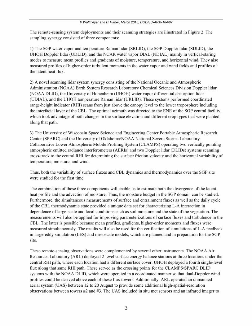
The remote-sensing system deployments and their scanning strategies are illustrated in Figure 2. The sampling synergy consisted of three components:
1) The SGP water vapor and temperature Raman lidar (SRLID), the SGP Doppler lidar (SDLID), the UHOH Doppler lidar (UDLID), and the NCAR water vapor DIAL (NDIAL) mainly in vertical-staring modes to measure mean profiles and gradients of moisture, temperature, and horizontal wind. They also measured profiles of higher-order turbulent moments in the water vapor and wind fields and profiles of the latent heat flux.
2) A novel scanning lidar system synergy consisting of the National Oceanic and Atmospheric Administration (NOAA) Earth System Research Laboratory Chemical Sciences Division Doppler lidar (NOAA DLID), the University of Hohenheim (UHOH) water vapor differential absorption lidar (UDIAL), and the UHOH temperature Raman lidar (URLID). These systems performed coordinated range-height indicator (RHI) scans from just above the canopy level to the lower troposphere including the interfacial layer of the CBL. The optimal azimuth was directed to the ENE of the SGP central facility, which took advantage of both changes in the surface elevation and different crop types that were planted along that path.
3) The University of Wisconsin Space Science and Engineering Center Portable Atmospheric Research Center (SPARC) and the University of Oklahoma/NOAA National Severe Storms Laboratory Collaborative Lower Atmospheric Mobile Profiling System (CLAMPS) operating two vertically pointing atmospheric emitted radiance interferometers (AERIs) and two Doppler lidar (DLIDs) systems scanning cross-track to the central RHI for determining the surface friction velocity and the horizontal variability of temperature, moisture, and wind.
Thus, both the variability of surface fluxes and CBL dynamics and thermodynamics over the SGP site were studied for the first time.
The combination of these three components will enable us to estimate both the divergence of the latent heat profile and the advection of moisture. Thus, the moisture budget in the SGP domain can be studied. Furthermore, the simultaneous measurements of surface and entrainment fluxes as well as the daily cycle of the CBL thermodynamic state provided a unique data set for characterizing L-A interaction in dependence of large-scale and local conditions such as soil moisture and the state of the vegetation. The measurements will also be applied for improving parameterizations of surface fluxes and turbulence in the CBL. The latter is possible because mean profiles, gradients, higher-order moments and fluxes were measured simultaneously. The results will also be used for the verification of simulations of L-A feedback in large-eddy simulation (LES) and mesoscale models, which are planned and in preparation for the SGP site.
These remote-sensing observations were complemented by several other instruments. The NOAA Air Resources Laboratory (ARL) deployed 2-level surface energy balance stations at three locations under the central RHI path, where each location had a different surface cover. UHOH deployed a fourth single-level flux along that same RHI path. These served as the crossing points for the CLAMPS/SPARC DLID systems with the NOAA DLID, which were operated in a coordinated manner so that dual-Doppler wind profiles could be derived above each of these flux towers. Additionally, ARL operated an unmanned aerial system (UAS) between 12 to 20 August to provide some additional high-spatial-resolution observations between towers #2 and #3. The UAS included in situ met sensors and an infrared imager to
V Wulfmeyer and D Turner, March 2018, DOE/SC-ARM-18-007
3
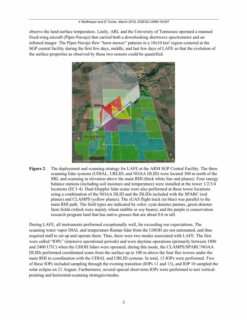
observe the land-surface temperature. Lastly, ARL and the University of Tennessee operated a manned fixed-wing aircraft (Piper-Navajo) that carried both a downlooking shortwave spectrometer and an infrared imager. The Piper-Navajo flew “lawn mower” patterns in a 10x10 km2 region centered at the SGP central facility during the first few days, middle, and last few days of LAFE so that the evolution of the surface properties as observed by these two sensors could be quantified.
Figure 2. The deployment and scanning strategy for LAFE at the ARM SGP Central Facility. The three
scanning lidar systems (UDIAL, URLID, and NOAA DLID) were located 300 m north of the SRL and scanning in elevation above the main RHI (thick white line and planes). Four energy balance stations (including soil moisture and temperature) were installed at the tower 1/2/3/4 locations (EC1-4). Dual-Doppler lidar scans were also performed at these tower locations using a combination of the NOAA DLID and the DLIDs included with the SPARC (red planes) and CLAMPS (yellow planes). The sUAS flight track (in blue) was parallel to the main RHI path. The field types are indicated by color: cyan denotes pasture, green denotes farm fields (which were mainly wheat stubble or soy beans), and the purple is conservation research program land that has native grasses that are about 0.6 m tall.
During LAFE, all instruments performed exceptionally well, far exceeding our expectations. The scanning water vapor DIAL and temperature Raman lidar from the UHOH are not automated, and thus required staff to set up and operate them. Thus, there were two modes associated with LAFE. The first were called “IOPs” (intensive operational periods) and were daytime operations (primarily between 1800 and 2400 UTC) when the UHOH lidars were operated; during this mode, the CLAMPS/SPARC/NOAA DLIDs performed coordinated scans from the surface up to 100 m above the four flux towers under the main RHI in coordination with the UDIAL and URLID systems. In total, 13 IOPs were performed. Two of these IOPs included sampling through the evening transition (IOPs 11 and 13), and IOP 10 sampled the solar eclipse on 21 August. Furthermore, several special short-term IOPs were performed to test vertical-pointing and horizontal-scanning strategies/modes.

V Wulfmeyer and D Turner, March 2018, DOE/SC-ARM-18-007
4
During non-IOP periods, the UDIAL and URLID were not operated. However, as the other systems are automated, they continued to collect data throughout the diurnal cycle. The SPARC, CLAMPS, and NOAA DLIDs were modified to perform a triple Doppler lidar scan above tower #2 from the surface up to 700 m. The temporal resolution of these scans was about 2 minutes. This maximum height was a compromise between getting well above the peak wind speed “nose” of the nocturnal low-level jet (if it formed) while maintaining good temporal resolution.
LAFE is a multi-agency, multi-nation project. It was funded by DOE’s ARM Facility, NOAA’s Office of Weather and Air Quality, the National Aeronautics and Space Administration (NASA)’s Energy and Water Cycle Study program, the German Federal Ministry of Education and Research (BMBF), and the University of Hohenheim.
2.0 Results During each IOP, surface-layer scans of the NOAA DLID, the UDIAL, and the URL are available with a resolution of 50 min and an angular range of 0-7 degrees. Afterwards, full RHI scans of these instruments were performed for 10 min over approx. 0-90 degrees. This scan strategy was continued for the full duration of the IOP. If observations were collected during an evening transition, the surface-layer scans were increased to a slightly higher angular range. During the 50-min, low-level scans, the DLIDs of SPARC and CLAMPS performed tower scans at the crossing points over the surface energy balance stations. During the 10-min RHIs of the UDIAL and the URL, the other DLIDs performed dual- and triple-Doppler scans in the surface layer.
The highlights of the campaign include:
• The first 2D measurements of water-vapor and temperature fields from the surface to the lower troposphere
• New operation modes of Doppler lidars for combined measurements of wind, turbulence kinetic energy (TKE), and momentum flux profiles
• New synergetic data sets for surface profile and flux derivations
• The solar eclipse as a unique natural experiment for studying L-A feedback.
Due to the strong connection between the pre-convective state of the CBL and the formation of clouds and precipitation, this new generation of experiments will strongly contribute to the improvement of their representation in weather, climate, and earth system models.
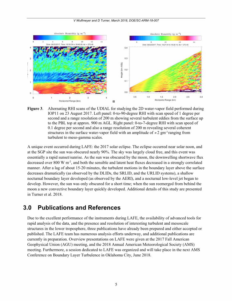
Figure 3 shows an example of surface-layer scans demonstrating the high temporal and spatial resolution as well as the high accuracy of the UDIAL measurements in the surface layer. Typically, strong micro- to meso-gamma-scale structures were found that were related to deep entrainment from the CBL top. This result questions the applicability of Monin-Obhukov scaling theory in the surface layer and may call for the development of new parameterizations of surface fluxes in heterogeneous terrain.
V Wulfmeyer and D Turner, March 2018, DOE/SC-ARM-18-007
5
Figure 3. Alternating RHI scans of the UDIAL for studying the 2D water-vapor field performed during
IOP11 on 23 August 2017. Left panel: 0-to-90-degree RHI with scan speed of 1 degree per second and a range resolution of 200 m showing several turbulent eddies from the surface up to the PBL top at approx. 900 m AGL. Right panel: 0-to-7-degree RHI with scan speed of 0.1 degree per second and also a range resolution of 200 m revealing several coherent structures in the surface water-vapor field with an amplitude of ≈ 2 gm-3 ranging from turbulent to meso-gamma scales.
A unique event occurred during LAFE: the 2017 solar eclipse. The eclipse occurred near solar noon, and at the SGP site the sun was obscured nearly 90%. The sky was largely cloud free, and this event was essentially a rapid sunset/sunrise. As the sun was obscured by the moon, the downwelling shortwave flux decreased over 800 W m-2, and both the sensible and latent heat fluxes decreased in a strongly correlated manner. After a lag of about 15-20 minutes, the turbulent motions in the boundary layer above the surface decreases dramatically (as observed by the DLIDs, the SRLID, and the URLID systems), a shallow nocturnal boundary layer developed (as observed by the AERI), and a nocturnal low-level jet began to develop. However, the sun was only obscured for a short time; when the sun reemerged from behind the moon a new convective boundary layer quickly developed. Additional details of this study are presented in Turner et al. 2018.
3.0 Publications and References Due to the excellent performance of the instruments during LAFE, the availability of advanced tools for rapid analysis of the data, and the presence and resolution of interesting turbulent and mesoscale structures in the lower troposphere, three publications have already been prepared and either accepted or published. The LAFE team has numerous analysis efforts underway, and additional publications are currently in preparation. Overview presentations on LAFE were given at the 2017 Fall American Geophysical Union (AGU) meeting, and the 2018 Annual American Meteorological Society (AMS) meeting. Furthermore, a session dedicated to LAFE was organized and will take place in the next AMS Conference on Boundary Layer Turbulence in Oklahoma City, June 2018.
V Wulfmeyer and D Turner, March 2018, DOE/SC-ARM-18-007
6
Santanello, JA, PA Dirmeyer, CR Ferguson, KL Findell, AB Tawfik, A Berg, M Ek, P Gentine, B. P Guillod, C van Heerwaarden, J Roundy, and V Wulfmeyer. 2017. “Land-Atmosphere Interactions: The LoCo Perspective.” Bulletin of the American Meteorological Society, doi:10.1175/BAMS-D-17-0001.1.
Turner, DD, V Wulfmeyer, A Behrendt, TA Bonin, A Choukulkar, RK Newsom, WA Brewer, DR Cook. 2017. “Response of the Land-Atmosphere System over North-Central Oklahoma during the 2017 Eclipse.” Geophysical Research Letters 45(3): 1668-1675, doi:10.1002/2017GL076908.
Wulfmeyer, V, DD Turner, B Baker, R Banta, A Behrendt, T. Bonin, WA Brewer, M Buban, A Choukulkar, E Dumas, RM Hardesty, T Heus, J Ingwersen, D Lange, TR Lee, S Metzendorf, SK Muppa, T. Meyers, R Newsom, M Osman, S Raasch, J Santanello, C Senff, F Späth, T Wagner, T Weckwerth, 2017. “A new research approach for observing and characterizing land-atmosphere feedback.” Bulletin of the American Meteorological Society, doi:10.1175/BAMS-D-17-0009.1.
4.0 Lessons Learned The site managers at Argonne National Laboratory provided excellent support for LAFE. In particular, the ANL group coordinated the transport of the two scanning lidars from the University of Hohenheim to the SGP site and back; their effort was absolutely critical for the success of LAFE. Additionally, the staff at the SGP were exceptional, providing constructive suggestions and helping as we were setting our instruments up at the beginning of LAFE, and riding to the rescue when the site received in excess of 5 inches of rain over two days in the middle of the experiment and a couple of the LAFE facilities were threatened by the rising waters. The SGP staff even built a small air-conditioned shed for our laser safety spotter so that (s)he would remain comfortable and attentive while monitoring the region we were sampling with the scanning laser systems for aircraft and vehicles. We cannot say enough good things about the support we received.