Embed Size (px)
Citation preview

1
Department for Environment and Heritage
Murraylands Region
Katfish Reach Conservation Asset Condition Report
January 2008

2
ACKNOWLEDGMENTS
Data Collection & Writer: Mike Harper (Wetland Officer)
Published by the Department for Environment and Heritage, Berri, South Australia
© Department for Environment and Heritage, 2007 Project Funded by; River Murray Improvement Fund
For further information contact:
Regional Conservation Directorate, Murraylands Department for Environment and Heritage Berri Office 28 Vaughan Terrace Berri SA 5343 AUSTRALIA
Phone: (61 8) 8595 2111
FRONT COVER PHOTOGRAPHS:
Photograph 1: The Splash (Photo by DEH)
Photograph 2: Wetland No 408 (Pyap Reach) (Photo by DEH)

3
Table of Contents
Conservation Asset Condition Summary .. .4
Condition Assessment Methodology 10
Results
Katarapko Creek ...14
Results - Eckert Creek, The Splash & Sawmill Creek . .......17
Results - Murray Hardyhead Habitat .26
Results
Temporary Wetlands ...27
Results
Dune System ...40
Results - Floodplain Vegetation .44
Tables
Table 1: Summary of Individual Temporary Wetland Condition ..7 Table 2: Summary of Individual Dune Condition ..8 Table 3: description of Vegetation Communities within the Floodplain
Woodland & Floodplain Shrubland & Open plain Vegetation Assets 44
Table 4: Comparison between dominate floodplain tree species Health c lass in 2002 and 2007 50
Figures
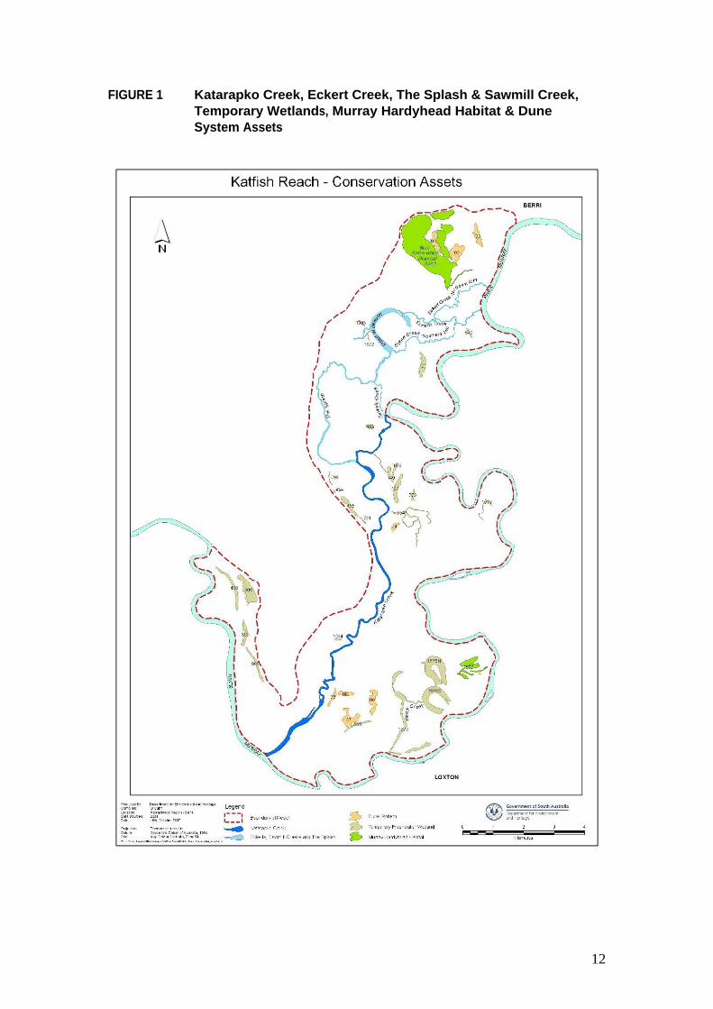
Figure 1; Katarapko Creek, Eckert Creek, The Splash & Sawmill Creek, Temporary Wetlands, Murray Hardyhead Habitat & Dune System Assets .. ..12
Figure 2: Floodplain Woodland & Floodplain Shrubland and Open Plain Vegeta tion Assets 13
Figure 3: Ka tfish Reac h Vegeta tion Communities 45 Figure 4 Representative Photograph of each Vegetation Community...46 Figure 4: Floodplain Woodland Health 2002 . .....48 Figure 5: Floodplain Woodland Hea lth 2007 . .....49
Appendix
Appendix 1 Plant Spec ies Common & Sc ientific Name .. .51

4
Conservation Asset Condition Summary
Katarapko Creek
Katarapko Creek (Segment 1) (13.7Km) A diverse section of healthy waterway, with a channel width ranging from 40 to 80 meters. In stream vegetation is dominated by Floating Pondweed with patches of Common Reed, Cumbungi, Water Primrose, Ribbon Weed, Curly Pondweed and Three-cornered Bulrush with high numbers of snags throughout the length of the waterway and areas of exposed tree roots along the sections of vertical bank. River Red Gum and Cooba dominated the riparian vegetation with areas of understorey dominated by Lignum, Native Cherry, Nitre Bush and Lippia. The Littoral Zone is dominated by Common Reed and Spiny Sedge.
Katarapko Creek (Segment 2) (2.5Km) A shallow diverse section of healthy waterway, with a channel width ranging from 120 to 160 meters. In stream vegetation is dominated by Floating Pondweed with patches of Common Reed, Water Primrose, Curly Pondweed and Three-cornered Bulrush with moderate numbers of snags throughout the length of the waterway. Gentle sloping bank dominates resulting in no exposed tree roots. River Red Gum dominated the riparian vegetation with areas of understorey dominated by Ruby Saltbush, Spiny Sedge, Hop Bush and Creeping Boobialla. The Littoral Zone is dominated by Common Reed with sections of Spiny Sedge and Three-cornered Bulrush.
Eckert Creek, The Splash & Sawmill creek
Eckert Creek Northern Arm (3m) A 12 to 22 meter wide shallow creek dominated by Cumbungi and Common Reed with few snags and exposed tree roots. . Within the river flush zone healthy River Red Gums dominated the riparian vegetation changing to healthy Black Box and Dryland Tea Tree towards the Lock 4 road bridge. Below the bridge there is little riparian tree vegetation that consists of dead or unhealthy Black Box. Spiny Sedge, Common Reed and Water Couch dominate the littoral zone until the junction with the Berri Drainage Water Disposal Basin outlet creek. Beyond this junction to the creek mouth the littoral zone is significantly effect by salt scolding and actively eroding in sections.
Eckert Creek Southern Arm (3.4Km) A 8 to 21 meter wide stable shallow creek predominately chocked with Cumbungi with areas of Common Reed and Three-cornered Bulrush and some scattered snags. Unhealthy Black Box dominates the riparian vegetation with patches of dead cut River Red Gum with pig face understorey. The littoral zone is dominated by Samphire and Spiny Rush with major salt scolding throughout the upstream half of the waterway.

5
Eckert Creek (4Km) A devise waterway, with a channel width ranging from 7 to 34 meters with an average depth of >1meter. The vertical bank profile that dominates is actively eroding in many areas especially below the Lock4 Bridge. In stream vegetation is dominated by Cumbungi and Water Primrose with sections of snags and few exposed tree roots. Black Box dominates the riparian vegetation with patches of Dryland Tea Tree and scattered River Red Gum above the Lock 4 road bridge. The majority of vegetation is unhealthy with some patches of healthy Black Box. The littoral zone is dominated by Common Reed and Water Couch, whoever below the junction of the Eckert Creek Northern Arm there area areas of salt scolding and dead Black Box.
Eckert Creek Wide-Waters (45.8ha) An ancestral oxbow with an average depth of 800mm. Riparian vegetation dominated by unhealthy Black Box and Cooba with patches of River Red Gum dead or unhealthy. Spike Rush and Water Couch dominated the littoral zone with salt scolding along the northern arm. The aquatic vegetation is diverse with Ribbon Weed and Curly Pondweed dominating with large patches of Cumbungi along the bank margins. Other species include Floating Pond Weed, Giant Sedge and Three-cornered Bulrush.
Sawmill Creek (1.4K) A narrow fast flowing shallow waterway, with a channel width ranging from 4 to 8 meters. The predominately low vertical bank profile seams to be stable. The devise in- stream vegetation is dominated by Cumbungi with areas of Water Primrose, Floating Pond Weed, Giant Sedge, Three-cornered Bulrush and Azolla. A number of snags are scattered along the waterway. Healthy River Red Gum and Cooba dominate the riparian vegetation with Spiny Sedge dominating the littoral zone.
The Splash (Segment 1) (3Km) A section of healthy waterway, with a channel width ranging from 20 to 30 meters with an average depth of >1 meter. In stream vegetation is dominated by Cumbungi, Water Primrose and Three-cornered Bulrush with snags throughout the length of the waterway and areas of exposed tree roots. In some sections the creek it is chocked by water plants, silt and snags. River Red Gum and Cooba dominated the riparian vegetation with Spiny Sedge and Water Couch dominating the littoral zone.
The Splash (Segment 2) (3.9Km)
A diverse section of healthy waterway, with a channel width ranging from 10 to over 50 meters with an average depth of ??. In stream vegetation is dominated by Three-cornered Bulrush, Ribbon Weed and area of Cumbungi. The majority of the waterway has no snag or exposed roots as the riparian vegetation is dominated by River Red Gum regeneration and Lignum however there are section of sparse adult River Red Gum and Cooba with Lignum and spiny sedge understorey. Three-cornered Bulrush and Spiny Sedge dominate the littoral zone

6
Murray Hardyhead Habitat
Murray Hardyhead are presently only found at the Berri Saline Water Disposal Basin. The basin covers an area of approximately 239hectares however due to water depth variations within the main basin area Murray Hardyhead are only regularly found in the Outlet Creek. The creek is about 1.4km long and covers an area of 2.2hectares. The dominate aquatic vegetation is Common Reed with areas of Three-cornered Bulrush, Cumbungi, Chara spp., Ruppia spp. and filament Algae. The littoral zone is dominated by Common Reed and Samphire. The wetland water supply is via the Monash and Puddletown outfalls from the Berri Irriga tion Area and river wa ter from the Basin s downstream inlet structure. It is predicated that in the future drainage water volumes will be <1 gigalitre during a normal irrigation year. At present the average water salinity is 3.980 EC from the Monash outfall and 11,250EC from Puddletown outfall.
The Katarapko Island Saline Water Disposal Basin Northern Lagoons (Wetland No 1577) is a site of Murray Hardhead potential habitat and until 2007 was a permanent wetland supplied by saline drainage water from the Loxton Irrigation Area. The wetland consists of five interconnecting shallow lagoons covering an area of 13.3hectares with Cumbungi being the dominated aquatic vegetation. The riparian vegetation is dominated by River Red Gum, Lignum and Common Reed. It is predicated that in the future drainage water volumes will be approximately 1 gigalitre during a normal irrigation year with an average salinity of 2,500EC.
Temporary Wetlands There are 25 Temporary Wetlands covering an area of 222 hectares across the Katfish Reach ranging in size from 0.1 to 41.2 hectares (see Figure 1 for location). The majority of wetlands have significant death of River Red Gum due to the lack of flooding since the 2000 high river event and /or salinity. However wetlands which have received water in the past three year through either being a managed wetland site or part of the River Red Gum Rescue project still have healthy riparian vegetation. A of wetlands have structures or embankments as a result of present or past management practices for the site (see Table 1 for Summary of Individual Temporary Wetland Condition).
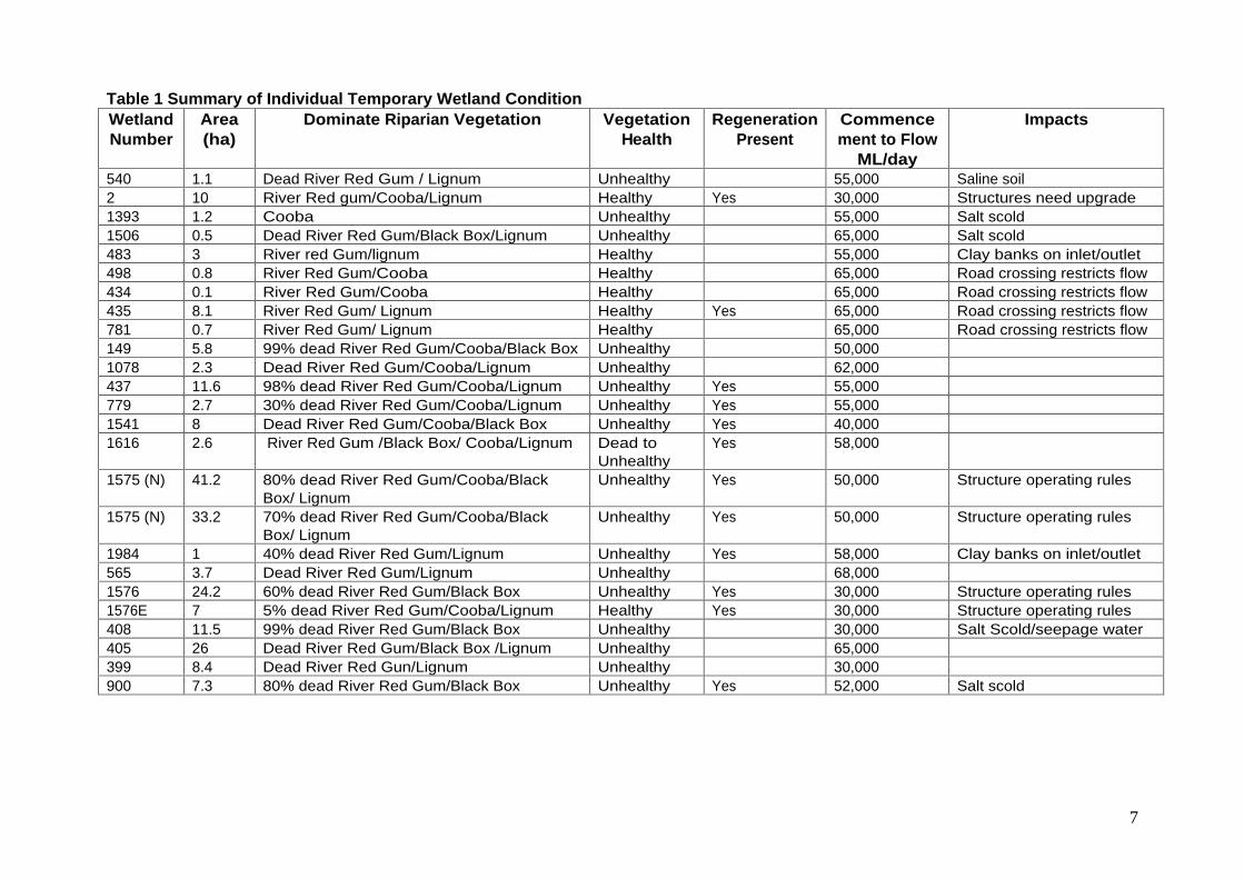
7
Table 1 Summary of Individual Temporary Wetland Condition Wetland Number
Area (ha)
Dominate Riparian Vegetation Vegetation Health
Regeneration
Present
Commencement to Flow
ML/day
Impacts
540 1.1 Dead River Red Gum / Lignum Unhealthy 55,000 Saline soil 2 10 River Red gum/Cooba/Lignum Healthy Yes 30,000 Structures need upgrade 1393 1.2 Cooba Unhealthy 55,000 Salt scold 1506 0.5 Dead River Red Gum/Black Box/Lignum Unhealthy 65,000 Salt scold 483 3 River red Gum/lignum Healthy 55,000 Clay banks on inlet/outlet 498 0.8 River Red Gum/Cooba Healthy 65,000 Road crossing restricts flow 434 0.1 River Red Gum/Cooba Healthy 65,000 Road crossing restricts flow 435 8.1 River Red Gum/ Lignum Healthy Yes 65,000 Road crossing restricts flow 781 0.7 River Red Gum/ Lignum Healthy 65,000 Road crossing restricts flow 149 5.8 99% dead River Red Gum/Cooba/Black Box Unhealthy 50,000 1078 2.3 Dead River Red Gum/Cooba/Lignum Unhealthy 62,000 437 11.6 98% dead River Red Gum/Cooba/Lignum Unhealthy Yes 55,000 779 2.7 30% dead River Red Gum/Cooba/Lignum Unhealthy Yes 55,000 1541 8 Dead River Red Gum/Cooba/Black Box Unhealthy Yes 40,000 1616 2.6 River Red Gum /Black Box/ Cooba/Lignum Dead to
Unhealthy Yes 58,000
1575 (N) 41.2 80% dead River Red Gum/Cooba/Black Box/ Lignum
Unhealthy Yes 50,000 Structure operating rules
1575 (N) 33.2 70% dead River Red Gum/Cooba/Black Box/ Lignum
Unhealthy Yes 50,000 Structure operating rules
1984 1 40% dead River Red Gum/Lignum Unhealthy Yes 58,000 Clay banks on inlet/outlet 565 3.7 Dead River Red Gum/Lignum Unhealthy 68,000 1576 24.2 60% dead River Red Gum/Black Box Unhealthy Yes 30,000 Structure operating rules 1576E 7 5% dead River Red Gum/Cooba/Lignum Healthy Yes 30,000 Structure operating rules 408 11.5 99% dead River Red Gum/Black Box Unhealthy 30,000 Salt Scold/seepage water 405 26 Dead River Red Gum/Black Box /Lignum Unhealthy 65,000 399 8.4 Dead River Red Gun/Lignum Unhealthy 30,000 900 7.3 80% dead River Red Gum/Black Box Unhealthy Yes 52,000 Salt scold
8
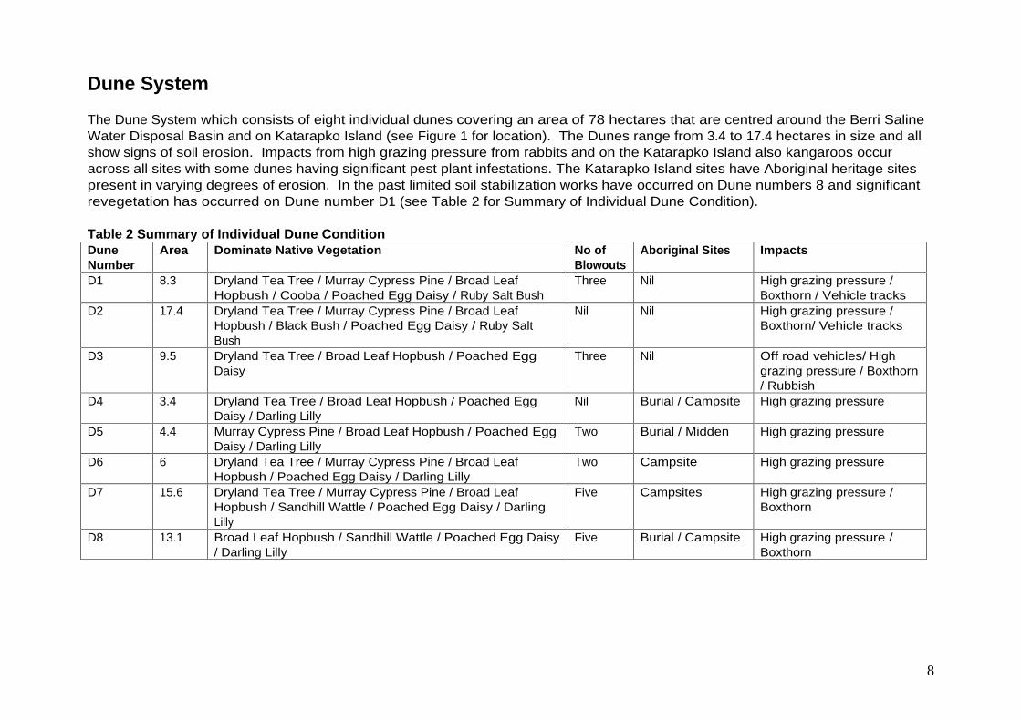
Dune System
The Dune System which consists of eight individual dunes covering an area of 78 hectares that are centred around the Berri Saline Water Disposal Basin and on Katarapko Island (see Figure 1 for location). The Dunes range from 3.4 to 17.4 hectares in size and all show signs of soil erosion. Impacts from high grazing pressure from rabbits and on the Katarapko Island also kangaroos occur across all sites with some dunes having significant pest plant infestations. The Katarapko Island sites have Aboriginal heritage sites present in varying degrees of erosion. In the past limited soil stabilization works have occurred on Dune numbers 8 and significant revegetation has occurred on Dune number D1 (see Table 2 for Summary of Individual Dune Condition).
Table 2 Summary of Individual Dune Condition Dune Number
Area Dominate Native Vegetation No of Blowouts
Aboriginal Sites Impacts
D1 8.3 Dryland Tea Tree / Murray Cypress Pine / Broad Leaf Hopbush / Cooba / Poached Egg Daisy / Ruby Salt Bush
Three Nil High grazing pressure / Boxthorn / Vehicle tracks
D2 17.4 Dryland Tea Tree / Murray Cypress Pine / Broad Leaf Hopbush / Black Bush / Poached Egg Daisy / Ruby Salt Bush
Nil Nil High grazing pressure / Boxthorn/ Vehicle tracks
D3 9.5 Dryland Tea Tree / Broad Leaf Hopbush / Poached Egg Daisy
Three Nil Off road vehicles/ High grazing pressure / Boxthorn / Rubbish
D4 3.4 Dryland Tea Tree / Broad Leaf Hopbush / Poached Egg Daisy / Darling Lilly
Nil Burial / Campsite High grazing pressure
D5 4.4 Murray Cypress Pine / Broad Leaf Hopbush / Poached Egg Daisy / Darling Lilly
Two Burial / Midden High grazing pressure
D6 6 Dryland Tea Tree / Murray Cypress Pine / Broad Leaf Hopbush / Poached Egg Daisy / Darling Lilly
Two Campsite High grazing pressure
D7 15.6 Dryland Tea Tree / Murray Cypress Pine / Broad Leaf Hopbush / Sandhill Wattle / Poached Egg Daisy / Darling Lilly
Five Campsites High grazing pressure / Boxthorn
D8 13.1 Broad Leaf Hopbush / Sandhill Wattle / Poached Egg Daisy / Darling Lilly
Five Burial / Campsite High grazing pressure / Boxthorn

9
Floodplain Woodland
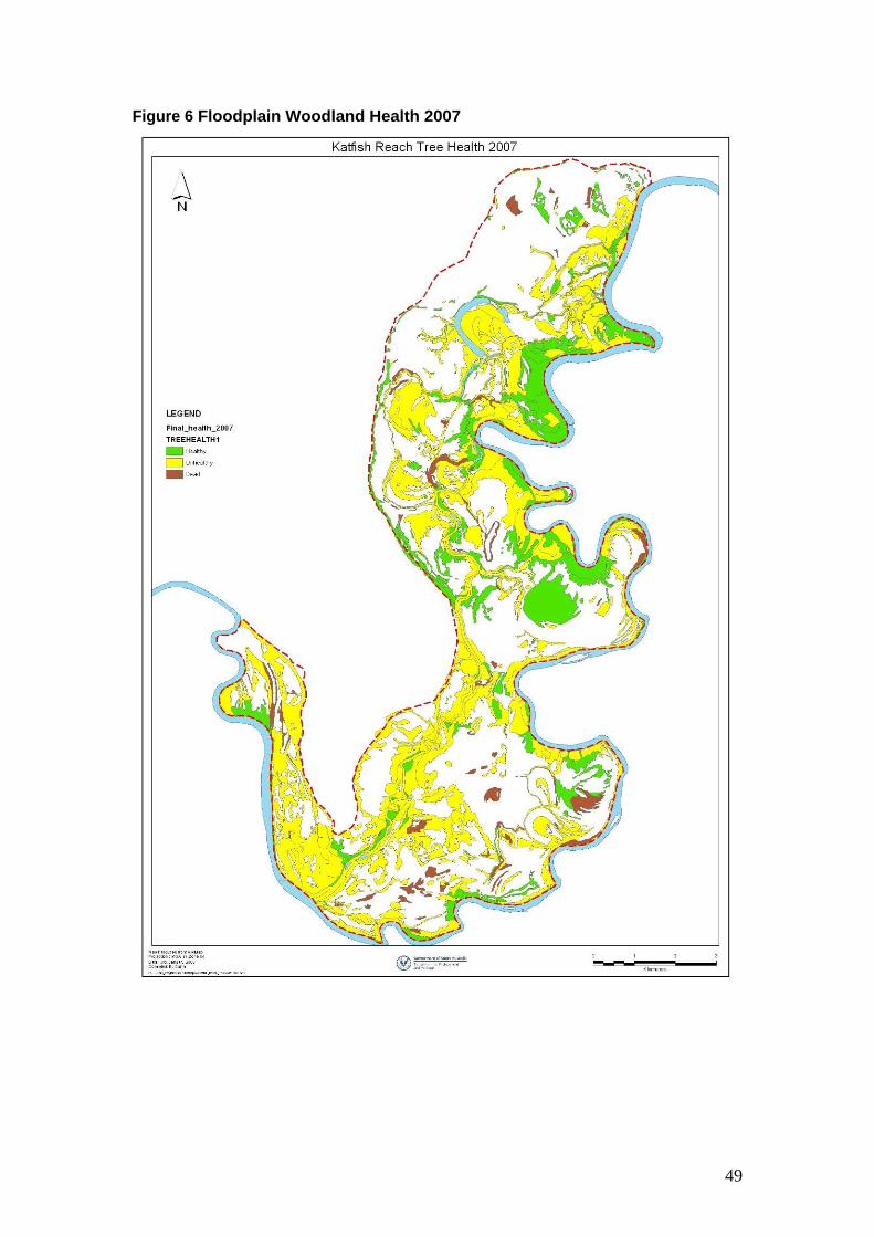
Health class of dominate tree species coverage in 2007 was 23% healthy, 72% unhealthy and 5% dead. The healthy woodland vegetation is centred on the river groundwater flush zone with the dominate areas of dead tree being River Red Gum adjacent to temporary wetland and creeks. Nearly 80% of Black Box was classed as unhealthy while only 60% of River Red Gum. The species with the largest percentage of dead trees with 9.4% was River Red Gum.
Floodplain Shrubland & Open Plain
The health of the floodplain shrubland and open plain was not formally assessed however observations indicate the following; As with the woodland areas the river groundwater flush zone also has healthy shrubland. Throughout the majority of the floodplain Lignum is unhealthy and dead in higher floodplain elevation areas and species such as Nitre Bush and Emu Bush are unhealthy In areas with soil salt accumulation ground cover species are dominate by +/- Samphire, Round-Leaf Pig Face and Desert Glasswort.

10
Condition Assessment Methodology
Waterways
The assessment methodology used to assess the waterways within the Katfish Reac h a rea was base on the approac h used in Rap id App ra isa l of Ripa rian Cond ition Version Two River and Riparian Land Management Technical Guideline Number A4. A detailed description of 500metre sections (1000metre section of Katarapko Creek segment 3) of the waterway was based on the following parameters; Channel width Number of snags and trees with exposed roots Bank profile Proportion of vegetated bank and littoral zone cover along one waterway bank Proportion of in stream vegetation cover Dominate bank, littoral zone and in-stream plant species Visual salinity impacts
A representative photograph of each survey site was taken.
Bathymetric surveys were undertaken of Eckert Creek, The Splash and Katarapko Creek to identify the depth contours of each major waterway.
The waterways were divided into a appropriate segments guided by changes in geomorphic character. Figure 1 identifies the waterway segments.
Murray Hardyhead Habitat
For the Berri Saline Water Disposal Basin site water salinity was recorded along the outlet creek every 100 to 150meters. Due to the Katarapko Island site being dry no water salinity survey was conducted. See Figure 1 for location
Riparian, aquatic and littoral zone vegetation was survey to identify dominate species and health.
Temporary Wetlands
Each wetland was visited and assess on the following parameters; Commenced to Flow (ML/day) using the Flood inundation model 111 Dominate riparian vegetation species and health class Wetland floor dominate species Pest plant species present Other impacts

11
A representative photograph was taken of each wetland. Figure 1 identity the location of the Temporary Wetlands.
Dune System
Each wetland was visited and assess on the following parameters; Dominate vegetation species and health class Soil erosion issues eg number of blow outs Aboriginal sites Pest pant species Other impacts
A representative photograph was taken of each wetland. Figure 1 identities the location of each individual dunes.
Floodplain Vegetation
Floodplain Tree health assessment was originally done in 2003 and repeated in 2007 using satellite Quickbird imagery @ 0.6m pixel size .
The following methodology was used to ground truth tree Health Assessment; Assess for all tree species (including living and dead) represented in the vegetation being sampled. Using the Tree Health Assessment, rate trees (5 0) for a total of 10 individual trees. If a mix of tree species are present then assess the 10 trees in proportion to dominance/codominance. E.g. 80% E. camaldulensis and 20% E. largiflorens = rate 8 x E. camaldulensis and 2 x E. largiflorens (living or dead). This may involve assessing trees outside the quadrat in nearby surrounds if 10 are not present within the quadrat. The percentage of original canopy present is the main determining criteria to use in assessing tree health
Tree Health Rating 0 Dead Tree 1 Unhealthy tree with no original canopy, all epicormic growth, most main branches dead. 2 Tree with <25% of original canopy present, >50% remaining canopy epicormic growth, some main branches dead. 3 Tree with 25 49% of original canopy present, <50% epicormic growth, some small dead branches. 4 Tree with 50 75% of original canopy present, <10% epicormic growth, some dead branchlets. 5 Tree with >75% of original canopy present, <5% epicormic growth, may include some dead branchlets and leaves.
The health of the floodplain shrubland and open plain was not formally assessed.
Figure 2 identities the Floodplain Woodland and Floodplain Shrubland and Open Plain assets.
12
FIGURE 1 Katarapko Creek, Eckert Creek, The Splash & Sawmill Creek,
Temporary Wetlands, Murray Hardyhead Habitat & Dune System Assets

13
Figure 2 Floodplain Woodland & Floodplain Shrubland & Open Plains
Vegetation Assets

14
Results
Karatapko Creek
Katarapko Creek (Segment 1)
Site 1 (Northern Bank) Site 2 (Northern Bank) GDA Upstream 458562 6198619 458473 6196607 GDA Downstream 458269 6198167 458790 6196263 Channel Width 48-60metres 55-75metres Snags 15 10 Exposed Roots 7 Trees Nil Bank Profile >70% vertical remainder vertical with toe 80% low vertical remainder gentle slope In Stream Vegetation <5% cover <5% cover
Water primrose/Ribbon Weed/Three-cornered Bulrush
Floating Pondweed/Curly Pondweed/Azolla/Common Reed
Littoral Zone Vegetation <30% cover >99% cover Three-cornered Bulrush Common reed dominate + Spiny Sedge/Water
Couch Riparian Vegetation 100% cover 100% cover
River Red Gum River Red Gum Understorey Native Cherry Understorey Lignum Healthy Healthy
Visual Salinity Impacts Nil Nil

15
Katarapko Creek (Segment 1) (Segment 2)
Site 3 (Northern Bank) Site 4 (Northern Bank) GDA Upstream 458245 6195387 457557 6191867 GDA Downstream 458390 6194874 457032 6191651 Channel Width 62-74metres 52-78metres Snags 7 24 Exposed Roots 3 Trees 2 Trees Bank Profile 100% vertical <30% vertical, <10% vertical with toe remainder
gentle slope In Stream Vegetation <1% cover <5% cover
Floating Pondweed dominate + Cumbungi /Common Reed
Floating pondweed/Common Reed/Three-cornered Bulrush
Littoral Zone Vegetation 100% cover >95% cover Common Reed /Spiny Sedge Common Reed /Spiny Sedge
Riparian Vegetation >80% cover 100% cover River Red Gum/Cooba River Red Gum/Cooba Understorey Hop Bush/ Lippia Understorey Lignum and many other floodplain
small perennials Healthy Healthy
Visual Salinity Impacts Nil Nil

16
Katarapko Creek (Segment 1) (Segment 2)
Site 5 (Northern Bank) Site 1 (Northern Bank) GDA Upstream 456944 6190718 456095 6189449 GDA Downstream 456676 6190468 455390 6188713 Channel Width 42-72metres 120-160metres Snags 15 20 Exposed Roots 5 Nil Bank Profile 70% vertical remainder gentle slope <10% vertical remainder gentle slope In Stream Vegetation <5% Cover <30% Cover
Floating Pondweed dominate + Three-cornered Bulrush / Common Reed/Curly Pondweed
Floating pondweed dominate + Three-cornered Bulrush/Curley Pondweed/Water Primrose/Common Reed
Littoral Zone Vegetation >85% Cover >95% Cover Common Reed/Three-corned Bulrush/Common Rush
Common Reed dominate + Common Rush/Spiny Sedge/Three-cornered Bulrush
Riparian Vegetation >80% 100% River Red Gum/Cooba Understorey Lippia/Star Thistle/Nitre Bush
River Red Gum Understorey Ruby Saltbush/Spiny Sedge/Hop Bush / Creeping Boobialla
Healthy Healthy Visual Salinity Impacts Nil Nil

17
Results Eckert Creek, The Splash & Sawmill Creek
Eckert Creek Northern Arm Site 1 (Northern Bank) Site 2(Northern Bank)
GDA Upstream 461602 6203636 460707 6203007 GDA Downstream 461256 6203453 460311 6202662 Channel Width 12-15metres 12-27metres Snags 2 3 Exposed Roots 2 trees 2 trees Bank Profile <10% vertical , remainder gentle slope <10% vertical , remainder gentle slope In Stream Vegetation >95% cover >80% cover
Cumbungi dominate + Common Reed / Water Primrose
Cumbungi / Common Reed dominate + Azolla / Duck Weed / Three-Corned Bulrush / River Club Rush
Littoral Zone Vegetation >95% cover <30% cover Spiny Sedge / Common Reed / Water Couch Water Couch / Common Reed / Samphire
Riparian Vegetation >95% cover <5% cover Black Box dominate + Cooba / Dryland Tea Tree/ River Red Gum
Black Box
Understorey Lignum / River Salt Bush Understorey Halosarcia spp. & Atriplex spp. Healthy Dead to Unhealthy
Visual Salinity Impacts Nil >70% shoreline scolding

18
Eckert Creek Southern Arm
Site 1 (Northern Bank) Site 2(Northern Bank) GDA Upstream 460992 6202112 459794 6201908 GDA Downstream 460544 6201877 459408 6201808 Channel Width 8-21metres 8-16metres Snags 2 77 Exposed Roots Bank Profile Gentle slope Gentle slope In Stream Vegetation >80% cover 100% cover
Cumbungi dominate + Common Reed / Three-cornered Bulrush / Azolla
Cumbungi dominate + Three-corned Bulrush
Littoral Zone Vegetation <70% cover >95% cover Samphire / Cumbungi / Water Couch Spiny Sedge / Three-corned Bulrush dominate +
Samphire / Cumbungi Riparian Vegetation <10% cover <40% cover
Black Box dominate + dead cut River Red Gum Black Box dominate + few River Red Gum & Cooba Understorey Lignum / Pig face Understorey Pig Face. Unhealthy Unhealthy a lot of cut dead River Red Gum
Visual Salinity Impacts Salt scolds and powdery soil along 60% of littoral zone
Small areas of powdery soil upstream end

19
Eckert Creek
Site 1 (Northern Bank) Site 2(Northern Bank) GDA Upstream 461582 6202667 460847 6202472 GDA Downstream 461371 6202387 460380 6202544 Channel Width 10-22metres 7-18metres Snags 11 1 Exposed Roots 1 tree 0 Bank Profile Predominately vertical with toe with two water
course entrances < 10% gentle slope, <20% vertical remainder vertical with toe
In Stream Vegetation <20% cover >40% cover Water Primrose dominate with Cumbungi / Azolla Cumbungi dominate + Mud Dock / Water Primrose /
Ribbon Weed / Floating Pond Weed Littoral Zone Vegetation 100% cover 100% cover
Common Reed Common Reed dominate with Water Couch on gentle sloping bank
Riparian Vegetation >95% cover >80% cover Black Box dominate + River Red Gum / Dryland Tea Tree
Black Box / River Red Gum dominate + Cooba
Understorey Lignum / River Salt Bush Understorey Lignum / River Salt Bush / Common Reed
Majority of Black Box & River Red Gum Unhealthy Black Box healthy, River Red Gum unhealthy Visual Salinity Impacts Down stream water course powdery soil with
Samphire Nil
Eckert Creek

20
Site 3 (Southern Bank)
GDA Upstream 459839 6202534 GDA Downstream 459440 6202751 Channel Width 14-34metres Snags 7 Exposed Roots 0 Bank Profile <70% vertical remainder gentle slope In Stream Vegetation >10% cover
Cumbungi dominate + Azolla / Three-cornered Bulrush
Littoral Zone Vegetation <50% cover Samphire / Water Couch dominate + Common Reed
Riparian Vegetation < 50% cover Black Box Understorey Lignum / Nitre Bush Unhealthy with numerous dead trees and Lignum
Visual Salinity Impacts <30% bank salt scolded

21
Eckert Creek Wide-Waters
Site 1 (Northern Bank) General Description of Wide-Waters
Riparian vegetation dominated by unhealthy Black Box and Cooba with patches of River Red Gum dead or unhealthy. Spike Rush and Water Couch dominated the littoral zone with salt scolding along the northern arm. In-stream vegetation was dominated by Ribbon Weed and Curly Pondweed, with large patches of Cumbungi along the bank margins. Cumbungi, Three-cornered Bulrush and Ribbon Weed dominated the two side arm waterways with significant salt scolding along the northern arm.
GDA Upstream 458643 6201208 GDA Downstream 458424 6200756 Channel Width 40-60metres Snags 9 Exposed Roots 0 Bank Profile Gentle slope In Stream Vegetation <2% cover
Cumbungi / Ribbon Weed dominate + Floating Pond Weed / Three-cornered Bulrush / Giant Sedge
Littoral Zone Vegetation 100% cover Spiny Sedge dominate + Native Liquorice
Riparian Vegetation >90% cover River Red Gum / Black Box / Cooba Understorey Spiny Sedge Black Box healthy, River Red Gum & Cooba unhealthy
Visual Salinity Impacts Nil

22
Sawmill
Site 1 (Western Bank) GDA Upstream 458507 6200354 GDA Downstream 458507 6199898 Channel Width 4 - 8metres Snags 7 Exposed Roots 1 tree Bank Profile >70% vertical remainder gentle slope In Stream Vegetation <80% cover
Cumbungi dominate + Ribbon Weed / Floating Pond Weed / Three-cornered Bulrush / Giant Sedge / Azolla
Littoral Zone Vegetation 60% cover Spiny Sedge dominate
Riparian Vegetation >80% cover River Red Gum / Cooba Understorey Lignum / Spiny Sedge Healthy
Visual Salinity Impacts Nil

23
The Splash (Segment 1)
Site 1 (Northern Bank) Site 2 (Northern Bank) GDA Upstream 457938 6200490 456809 6200879 GDA Downstream 457505 6200600 456527 6200565 Channel Width 20-23metres 20-30metres Snags 16 5 Exposed Roots 8 Trees 0 Bank Profile <70% vertical, <20% gentle slope, <10% vertical with
toe Gentle slope
In Stream Vegetation <15% cover <50% cover Cumbungi / Water Primrose dominate + Ribbon Weed / Common Reed
Cumbungi / Water Primrose / Three-cornered Bulrush dominate + Ribbon Weed / Common Reed / Water Couch
Littoral Zone Vegetation 100% cover 100% cover Spiny Sedge dominate + Common Reed Spiny Sedge / Water Couch dominate + Common
Reed / Three-cornered Bulrush Riparian Vegetation >90% cover <5% cover
River Red Gum / Cooba dominate + Black Box River Red Gum / Cooba Understorey Spiny Sedge / Lignum
Understorey Spiny Sedge / Lignum Healthy Healthy
Visual Salinity Impacts Nil Nil

24
The Splash (Segment 2)
Site 1 (Northern Bank) Site 2 (Northern Bank) GDA Upstream 456527 6200099 456719 6198838 GDA Downstream 456701 6199630 456515 6198378 Channel Width 15-20metres 42-53metres Snags 1 2 Exposed Roots 0 0 Bank Profile Gentle slope Gentle slope In Stream Vegetation <40% cover <50% cover
Three-cornered Bulrush / Cumbungi dominate + Water Primrose / Ribbon Weed / Common Reed
Ribbon Weed / Three-cornered Bulrush dominate + Water Primrose / Azolla
Littoral Zone Vegetation 100% cover 100% cover Spiny Sedge / Water Couch / Three-cornered Bulrush
Spiny Sedge / Three-cornered Bulrush / Native Liquorice
Riparian Vegetation <2% cover <50% cover River Red Gum (saplings & poles only) River Red Gum / Cooba Understorey Lignum / Sp iny Sedge / Ra t s Ta il Couch
Understorey Lignum / Spiny Sedge / Lignum
Healthy Healthy Visual Salinity Impacts Nil Nil

25
The Splash (Segment 2)
Site 3 (Northern Bank) ) GDA Upstream 456720 6197944 GDA Downstream 457153 6197772 Channel Width 10-18metres Snags Nil Exposed Roots Nil Bank Profile <305 low vertical remainder gentle slope In Stream Vegetation <15% cover
Three-cornered Bulrush/Azolla dominate + Cumbungi / Ribbon weed
Littoral Zone Vegetation 100% cover Spiny Sedge/Three-cornered Bulrush
Riparian Vegetation River Red Gum sapling & poles dominate + sapling Cooba Healthy
Visual Salinity Impacts Nil

26
Results Murray Hardyhead Habitat
Berri Saline Water Disposal Basin Outlet Creek Katarapko Island Saline Water Disposal Basin Northern Lagoons (Wetland No. 1577)
Length of waterway 1,400meters Area (hectares) 2.2 19.3ha Includes five lagoons Snags Few Scattered dead River Red Gum in lagoons Exposed Roots Few Bank Profile Predominately gentle slope, areas of vertical
profile Aquatic Vegetation <10% cover <40%
Common Reed dominate + Three-cornered Bulrush/Cumbungi/Chara spp,/Ruppia spp.
Dominated by Cumbungi
Littoral Zone Vegetation Common Reed/Samphire dominate Stinkwort dominate + Common Reed Riparian Vegetation Unhealthy Black Box with lignum understorey Unhealthy River Red Gum with lignum and
Common Reed understorey Water salinity Salinity gradient from inlet structure to Basin 1,900-
13,900EC s with two thirds of wa ter under 9,000EC s
Dry during survey Oct 2007
Water Supply Berri Irrigation Area via the Monash and Puddletown outfalls & inlet structure.
Loxton Irrigation Area via the northern outfall
Predicated Water Volume
<1 gigalitre Yearly average 1gigalitre Water Quality Average Monash 3,980EC, Puddletown 11,250EC Average 2,500EC
Northern lagoon taken 21/8/06

27
Results Temporary Wetlands
Bank H Creek Lagoon Ngak Indau Wetland Number 540 2 GDA 461482 6202083 459954 6201018 Area (Hectares) 1.1ha Basins 10ha managed wetland area 21.4ha Geomorphic Category Interconnecting Depositional Basin Interconnecting Depositional Basin Water Source Main river via bank H Main river via bank C Commence to Flow(ML/day)
55,000 Below pool level
Riparian Vegetation Lignum / River Red Gum River Red Gum/Cooba /Lignum Riparian Health Unhealthy / Long term dead River Red Gum Healthy Wetland Floor Vegetation Samphire Native Liquorice/Spiny Sedge/ Smooth Heliotrope Impacts (Barrier, Weed etc.)
Ground water seepage Swamp Chinese Lantern / Fish passage & flows

28
Eckert Wide-water North Arm Eckert Wide-water Flood Runner Gutter
Wetland Number 1393 1506 GDA 457800 6202460 458135 6202070 Area (Hectares) 1.2 0.5 Geomorphic Category Interconnecting Depositional Basin Interconnecting Depositional Basin Water Source Eckert Wide-water Eckert Wide-water Commence to Flow(ML/day)
55,000 65,000
Riparian Vegetation Cooba River Red Gum/Black Box/Lignum Riparian Health Unhealthy 100%River Red Gum dead/other veg unhealthy Wetland Floor Vegetation Salt Scold/Samphire/Spike Rush/Common Reed Salt Scold/Samphire Impacts (Barrier, Weed etc.)
Ground water seepage Ground water seepage

29
Piggy Creek Lagoon Katarapko Creek Car Park Lagoon 1
Wetland Number 483 498 GDA 458234 6199007 456883 6197281 Area (Hectares) 3ha 0.8ha Geomorphic Category Deflation Basin Interconnecting Depositional Basin Water Source Piggy Creek connected to main river and
Katarapko Creek Katarapko Creek & The Splash
Commence to Flow(ML/day)
55,000 65,000
Riparian Vegetation River Red Gum /Lignum River Red Gum/Cooba Riparian Health Healthy but insect attacked Healthy, <5% of River red Gum dead Wetland Floor Vegetation Low Chenopod spp. Bare ground Impacts (Barrier, Weed etc.)
Banks at both ends of Piggy Creek Inlet & Outlet road crossings

30
Katarapko Creek Car Park Lagoon 2 Katarapko Creek Car Park Lagoon 3
Wetland Number 434 435 GDA 457038 6196920 457578 6196392 Area (Hectares) 0.1ha 8.1ha Geomorphic Category Interconnecting Depositional Basin Interconnecting Depositional Basin Water Source Katarapko Creek & The Splash Katarapko Creek & The Splash Commence to Flow(ML/day)
65,000 65,000
Riparian Vegetation River Red Gum / Cooba River Red Gum / Lignum Riparian Health Healthy <10% River Red Gum dead Healthy <2% River Red Gum dead Wetland Floor Vegetation Bare ground Native Liquorice /sapling River Red Gum Impacts (Barrier, Weed etc.)
Inlet & Outlet road crossings Inlet & Outlet road crossings

31
Katarapko Creek Car Park Lagoon 4 Katarapko Island North Lagoon 1
Wetland Number 781 149 GDA 458013 6195848 458854 6197445 Area (Hectares) 0.7ha 5.8ha Geomorphic Category Interconnecting Depositional Basin Interconnecting Depositional Basin Water Source Katarapko Creek & The Splash Katarapko Creek Commence to Flow(ML/day)
65,000 50,000
Riparian Vegetation River Red Gum / Lignum River Red Gum/Cooba + Black box Riparian Health Healthy River Red Gum 99% Dead remainder of trees
healthy Wetland Floor Vegetation Bare Ground Lignum dominate + Nitre Bush/Chenopod spp. Impacts (Barrier, Weed etc.)
Inlet & Outlet road crossings

32
Katarapko Island North Lagoon 2 Katarapko Island North Lagoon 3
Wetland Number 1078 437 GDA 459060 6197653 459067 6196973 Area (Hectares) 2.3ha 11.6ha Geomorphic Category Interconnecting Depositional Basin Interconnecting Depositional Basin Water Source Katarapko Creek Katarapko Creek Commence to Flow(ML/day)
62,000 55,000
Riparian Vegetation Lignum dominate one patch of River Red Gum/Cooba in NW corner
River Red Gum/Cooba /Lignum
Riparian Health River Red Gum dead Lignum /Cooba healthy River Red Gum 98% dead remainder unhealthy, cooba healthy
Wetland Floor Vegetation
Lignum Lignum dominate + small areas of sapling Black Box/Cooba healthy to unhealthy
Impacts (Barrier, Weed etc.)
33
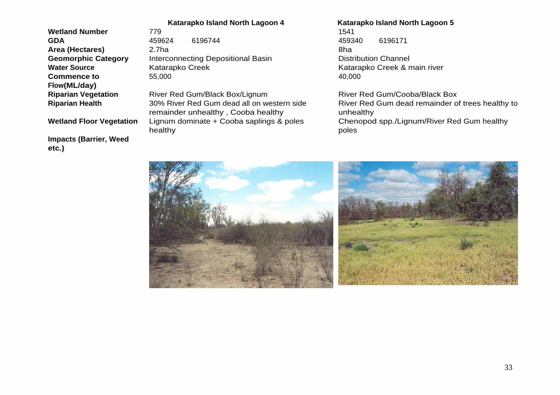
Katarapko Island North Lagoon 4 Katarapko Island North Lagoon 5
Wetland Number 779 1541 GDA 459624 6196744 459340 6196171 Area (Hectares) 2.7ha 8ha Geomorphic Category Interconnecting Depositional Basin Distribution Channel Water Source Katarapko Creek Katarapko Creek & main river Commence to Flow(ML/day)
55,000 40,000
Riparian Vegetation River Red Gum/Black Box/Lignum River Red Gum/Cooba/Black Box Riparian Health 30% River Red Gum dead all on western side
remainder unhealthy , Cooba healthy River Red Gum dead remainder of trees healthy to unhealthy
Wetland Floor Vegetation Lignum dominate + Cooba saplings & poles healthy
Chenopod spp./Lignum/River Red Gum healthy poles
Impacts (Barrier, Weed etc.)

34
Katarapko Island North Lagoon 6 Wetland Number 1616 GDA 462095 6196548 Area (Hectares) 2.6ha Geomorphic Category Discrete Depositional Basin Water Source Main river Commence to Flow(ML/day)
58,000
Riparian Vegetation River Red Gum, Black Box, Lignum Riparian Health Mature River Red Gums dead, River Red Gum poles
dead to epicormic growth, Lignum and Black Box unhealthy
Wetland Floor Vegetation Lignum, Black Box saplings, Cooba, Ruby Salt Bush Impacts (Barrier, Weed etc.)
35
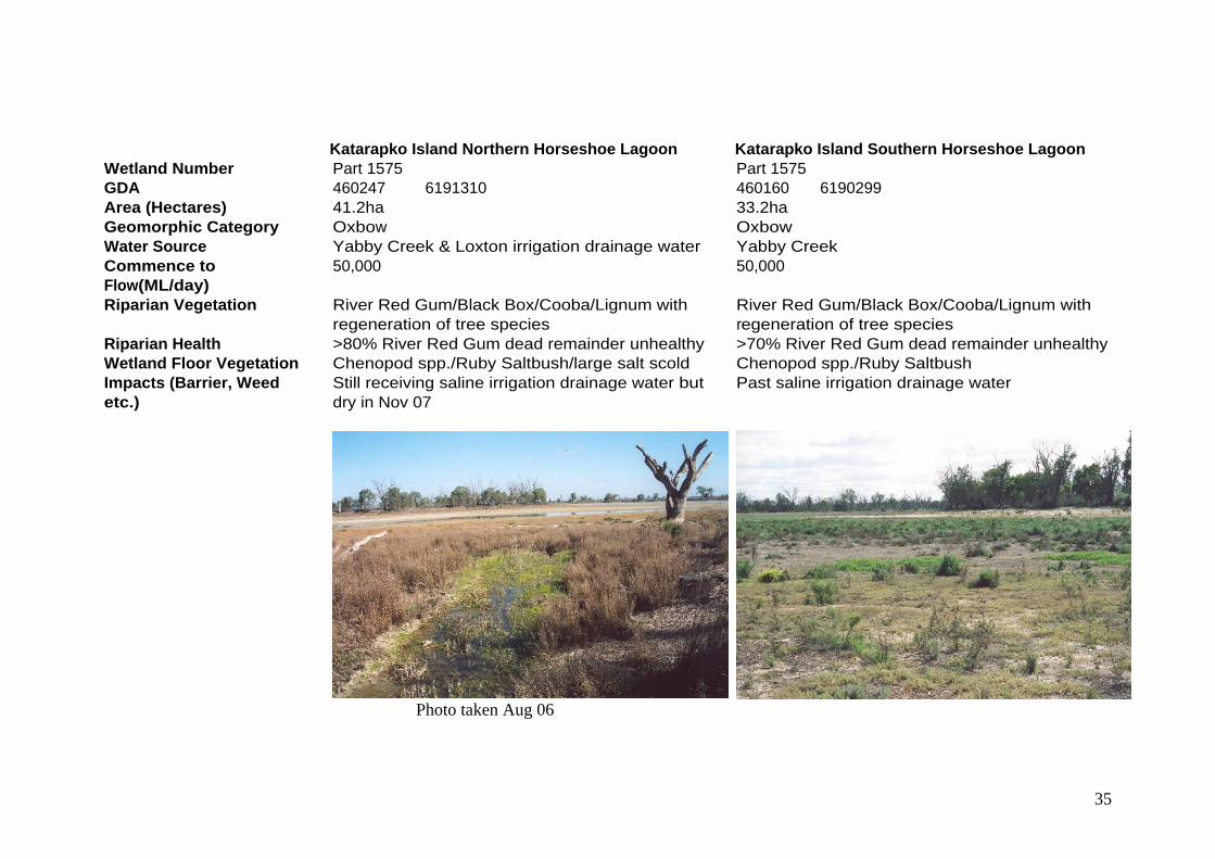
Katarapko Island Northern Horseshoe Lagoon Katarapko Island Southern Horseshoe Lagoon
Wetland Number Part 1575 Part 1575 GDA 460247 6191310 460160 6190299 Area (Hectares) 41.2ha 33.2ha Geomorphic Category Oxbow Oxbow Water Source Yabby Creek & Loxton irrigation drainage water Yabby Creek Commence to Flow(ML/day)
50,000 50,000
Riparian Vegetation River Red Gum/Black Box/Cooba/Lignum with regeneration of tree species
River Red Gum/Black Box/Cooba/Lignum with regeneration of tree species
Riparian Health >80% River Red Gum dead remainder unhealthy >70% River Red Gum dead remainder unhealthy Wetland Floor Vegetation Chenopod spp./Ruby Saltbush/large salt scold Chenopod spp./Ruby Saltbush Impacts (Barrier, Weed etc.)
Still receiving saline irrigation drainage water but dry in Nov 07
Past saline irrigation drainage water
Photo taken Aug 06

36
Katarapko Creek South Lagoon Sandhill Gutter South Katarapko Island
Wetland Number 1984 565 GDA 457185 6192012 457937 6189263 Area (Hectares) 1ha 3.7 Geomorphic Category Interconnecting Depositional Basin Distributary Channel Water Source Katarapko Creek Katarapko/Yabby Creeks Commence to Flow(ML/day)
58,000 68,000
Riparian Vegetation River Red Gum/Lignum River Red Gum/Lignum Riparian Health <40% River Red Gum dead remainder healthy to
unhealthy River Red Gum dead Lignum unhealthy
Wetland Floor Vegetation Chenopods./sapling & pole River Red Gum Lignum/Chenopod spp. Impacts (Barrier, Weed etc.)
Banks across inlet & outlet

37
Yabby Creek Katarapko Island Basin Southern Outfall Lagoon
Wetland Number 1576 1576E GDA 459297 6189487 459863 6188434 Area (Hectares) 24.2 7ha Geomorphic Category Distributary Channel Interconnecting Depositional Basin Water Source River Murray Yabby Creek & Loxton irrigation drainage water Commence to Flow(ML/day)
30,000 30,000
Riparian Vegetation Ligum + River Red Gum/Black Box adult, sapling & poles
River Red Gum/Cooba/Lignum
Riparian Health >60% River Red Gum dead reminder unhealthy <5% long term dead River Red Gum remainder healthy
Wetland Floor Vegetation River Red Gum/Black Box saplings & poles along central section Samphire/Pig face/salt scold
River Red Gum sapling & poles/Cumbungi/Burr spp. /Curled Dock
Impacts (Barrier, Weed etc.)
Central section salt scold Reduced drainage water

38
Pyap Reach Lagoon 1 Pyap Reach Lagoon 2
Wetland Number 408 405 GDA 453755 6192380 454141 6192200 Area (Hectares) 11.5ha 26ha Geomorphic Category Interconnecting Depositional Basin Discrete Depositional Basin Water Source Main river Main river Commence to Flow 30,000 65,000 Riparian Vegetation River Red Gum/Black Box/Samphire Black Box Riparian Health 99% dead River Red Gum/Unhealthy Black Box Unhealthy Wetland Floor Vegetation Samphire / Salt Seepage Water & Scolds Lignum/dead River Red Gum Impacts (Barrier, Weed etc.)
Ground water seepage

39
Pyap Reach Lagoon 3 Pyap Reach Lagoon 4
Wetland Number 399 900 GDA 454152 6192217 454508 6191198 Area (Hectares) 8.4ha 7.3ha Geomorphic Category Discrete Depositional Basin Interconnecting Depositional Basin Water Source Main river Main river Commence to Flow(ML/day)
30,000 52,000
Riparian Vegetation River Red Gum/Lignum River Rd Gum/Black Box/Hop Bush Riparian Health 100% River Red Gum dead/Lignum Unhealthy 80% River Red Gum dead/Black Box Unhealthy Wetland Floor Vegetation Lignum/Chenopod spp Salt Scold/Samphire/Ruby Saltbush Impacts (Barrier, Weed etc.)
Ground water seepage
40
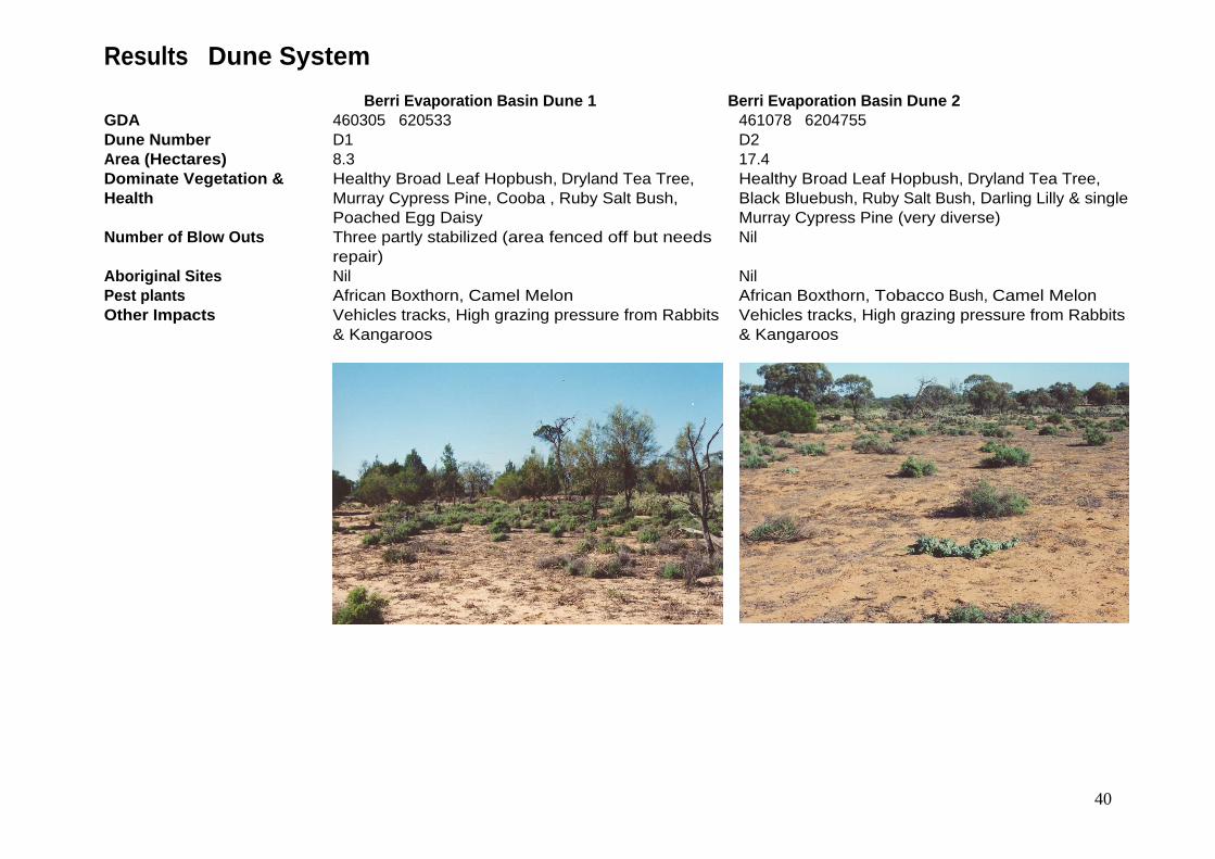
Results Dune System
Berri Evaporation Basin Dune 1 Berri Evaporation Basin Dune 2 GDA 460305 620533 461078 6204755 Dune Number D1 D2 Area (Hectares) 8.3 17.4 Dominate Vegetation & Health
Healthy Broad Leaf Hopbush, Dryland Tea Tree, Murray Cypress Pine, Cooba , Ruby Salt Bush, Poached Egg Daisy
Healthy Broad Leaf Hopbush, Dryland Tea Tree, Black Bluebush, Ruby Salt Bush, Darling Lilly & single Murray Cypress Pine (very diverse)
Number of Blow Outs Three partly stabilized (area fenced off but needs repair)
Nil
Aboriginal Sites Nil Nil Pest plants African Boxthorn, Camel Melon African Boxthorn, Tobacco Bush, Camel Melon Other Impacts Vehicles tracks, High grazing pressure from Rabbits
& Kangaroos Vehicles tracks, High grazing pressure from Rabbits & Kangaroos
41
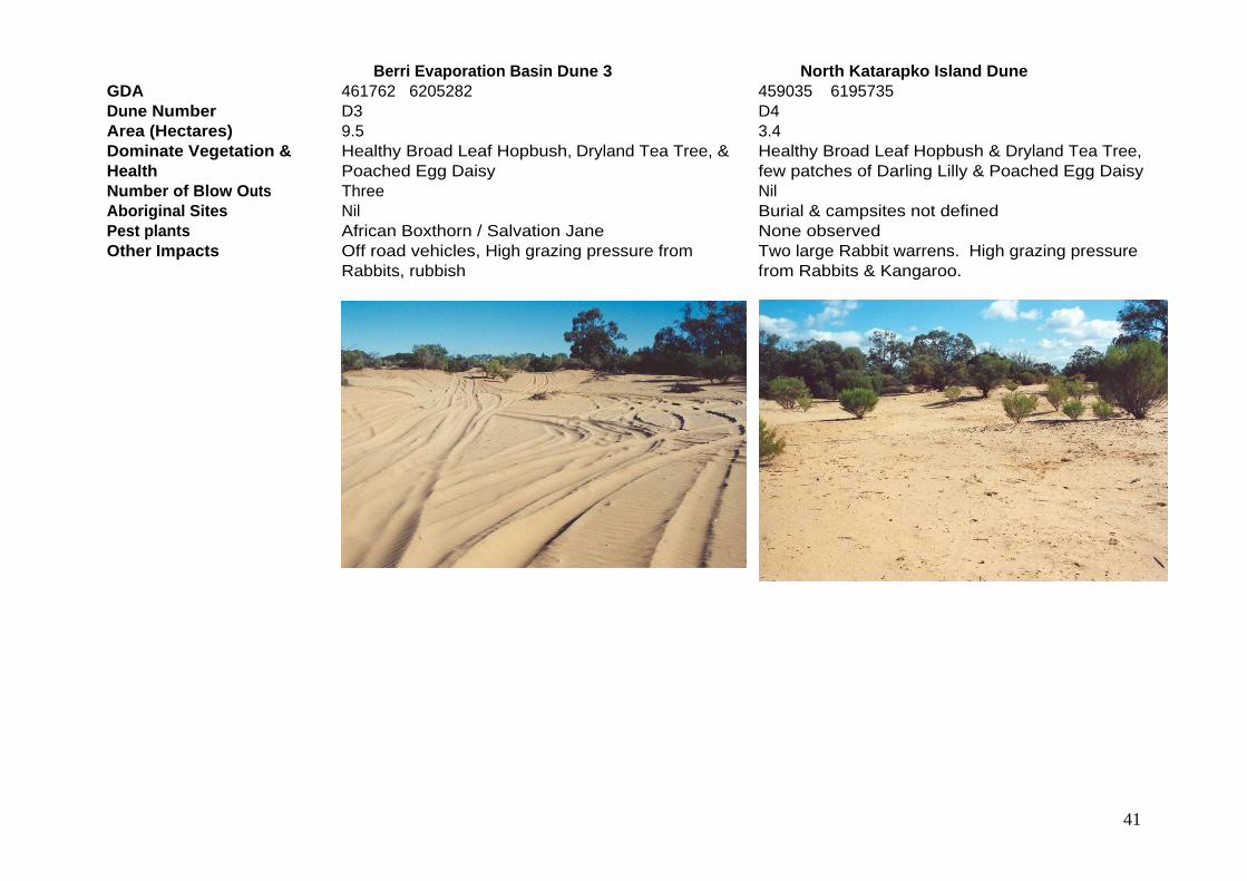
Berri Evaporation Basin Dune 3 North Katarapko Island Dune
GDA 461762 6205282 459035 6195735 Dune Number D3 D4 Area (Hectares) 9.5 3.4 Dominate Vegetation & Health
Healthy Broad Leaf Hopbush, Dryland Tea Tree, & Poached Egg Daisy
Healthy Broad Leaf Hopbush & Dryland Tea Tree, few patches of Darling Lilly & Poached Egg Daisy
Number of Blow Outs Three Nil Aboriginal Sites Nil Burial & campsites not defined Pest plants African Boxthorn / Salvation Jane None observed Other Impacts Off road vehicles, High grazing pressure from
Rabbits, rubbish Two large Rabbit warrens. High grazing pressure from Rabbits & Kangaroo.

42
South Katarapko Island Dune 1 South Katarapko Island Dune 2
GDA 457070 6190238 457347 6190241 Dune Number D5 D6 Area (Hectares) 4.4 6 Dominate Vegetation & Health
Healthy Broad Leaf Hopbush + Murray Cypress Pine with regeneration, few patches of Darling Lilly & Poached Egg Daisy
Healthy Broad Leaf Hopbush + Dryland Tea Tree/ a single Murray Cypress Pine /Poached Egg Daisy /Salvation Jane one patch of Darling Lilly
Number of Blowouts Two Two Aboriginal Sites One midden heap One campsite Pest plants None observed Salvation Jane dominate Other Impacts High grazing pressure from Rabbits & Kangaroo. High grazing pressure from Rabbits & Kangaroo.
43
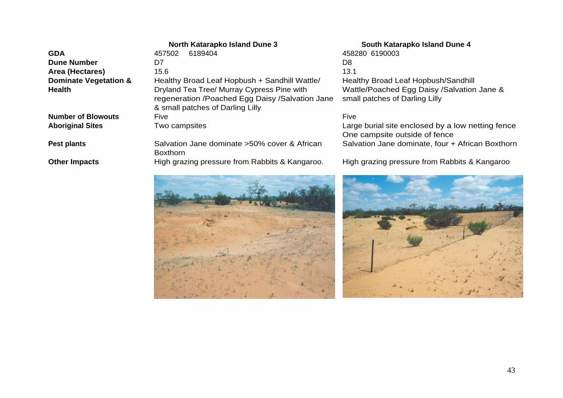
North Katarapko Island Dune 3 South Katarapko Island Dune 4
GDA 457502 6189404 458280 6190003 Dune Number D7 D8 Area (Hectares) 15.6 13.1 Dominate Vegetation & Health
Healthy Broad Leaf Hopbush + Sandhill Wattle/ Dryland Tea Tree/ Murray Cypress Pine with regeneration /Poached Egg Daisy /Salvation Jane & small patches of Darling Lilly
Healthy Broad Leaf Hopbush/Sandhill Wattle/Poached Egg Daisy /Salvation Jane & small patches of Darling Lilly
Number of Blowouts Five Five Aboriginal Sites Two campsites Large burial site enclosed by a low netting fence
One campsite outside of fence Pest plants Salvation Jane dominate >50% cover & African
Boxthorn Salvation Jane dominate, four + African Boxthorn
Other Impacts High grazing pressure from Rabbits & Kangaroo. High grazing pressure from Rabbits & Kangaroo

44
Result Floodplain Vegetation
Table 3 describes the vegetation communities within Floodplain Woodland & Floodplain Shrubland & Open Plain Vegetation Assets. Figure 3 identifies the location of each vegetation community and Figure 4 give a representative photograph of each vegetation community. Floodplain woodland health for 2002 and 2007 are presented in Figures 5 and 6.
Table 3 Description of Vegetation Communities within the Floodplain Woodland & Floodplain Shrubland & Open Plain Vegetation Assets
Description Area (ha) Percentage
Floodplain Woodland 4580 51 River Red Gum Eucalyptus camaldulensis over +/- Acacia stenophylla / Cyperus gymnocaulos /
Muehlenbeckia florulenta / Paspalidium jubiflorum / Phragmites australis 887 10
Black Box Eucalyptus largiflorens over +/- Acacia stenophylla / Atriplex rhagodioides / Chenopodium nitrariaceum / Enchylaena tomentosa / Maireana pyramidata /
Muehlenbeckia florulenta
1444 16
River Red Gum / Black Box
Eucalyptus camaldulensis / Eucalyptus largiflorens over +/- Acacia stenophylla / Chenopodium nitrariaceum / Enchylaena tomentosa / Halosarcia pergranulata /
Muehlenbeckia florulenta
1522 17
Cooba Acacia stenophylla over Chenopodium nitrariaceum / Enchylaena tomentosa / Muehlenbeckia florulenta
24 >1
Black Box / Lignum Eucalyptus largiflorens over +/- Muehlenbeckia florulenta / Enchylaena tomentosa 703 8 Floodplain Shrubland
& Open Plain 4208 49
Lignum Muehlenbeckia florulenta over +/- Enchylaena tomentosa / Halosarcia pergranulata / Sporobolus mitchelli
2142 24
Hop Bush Dodonaea viscosa over Bromus rubens 22 >1 Chenopod Shrubland +/- Atriplex rhagodioides / Atriplex lindleyi / Atriplex vesicaria / Chenopodium
nitrariaceum / Halosarcia halocnemoides / Halosarcia indica / Halosarcia pergranulata / Maireana breviflora / Pachycornia triandra / Sarcocornia quinqueflora / Sclerostegia
arbuscula / Sclerostegia tricuspis / Suaeda australis
1239 14
Grassland +/- Eragrostis australasica / Phragmites australis / Typha domingensis / Schoenoplectus validus / Sporobolus mitchelli / Sporobolus virginicus
774 9
Sedgeland Typha domingensis over +/- Paspalum distichum / Paspalum vaginatum / Schoenoplectus validus
1 >1
Herbland +/- Polycalymma sturtii / Disphyma crassifolium 30 >1

45
Figure 3 Katfish Reach Vegetation Communities

46
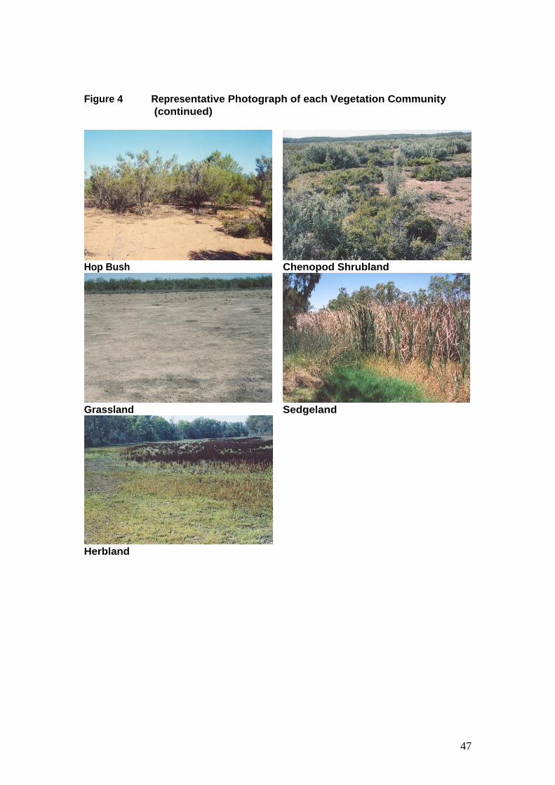
Figure 4 Representative Photograph of each Vegetation Community
River Red Gum Black Box
River Red Gum/Black Box Cooba
Black Box/Lignum Lignum
47
Figure 4 Representative Photograph of each Vegetation Community
(continued)
Hop Bush Chenopod Shrubland
Grassland Sedgeland
Herbland

48
Figure 5 Floodplain Woodland Health 2002
49
Figure 6 Floodplain Woodland Health 2007

50
Table 4 Comparison between dominate floodplain tree species health class in 2002 and 2007
Species /Health Class 2002 Hectares
2007
Hectares
% Change
Between 02 & 07 River Red Gum Eucalyptus camaldulensis Healthy 1180.7 457.3 -61% Unhealthy 646.4 892.1 +28% Dead 88.4 141.2 +37%
Black Box Eucalyptus largiflorens Healthy 557.4 432.6 -22% Unhealthy 1464.6 1935.7 +24% Dead 96.5 70.1* -28%
Cooba Acacia stenophylla Healthy 23.1 19.2 -17% Unhealthy 15.3 16.6 +8% Dead Nil Nil * Decrease in dead Black box is the result of more accurate mapping in 2007

51
Appendix 1 Plant Species Common and Scientific Names
African Boxthorn Lycium ferocissimum* Azolla Azolla spp. Black Bluebush Maireana pyramidata Black Box Eucalyptus largiflorens Broad Leaf Hopbush Dodonaea viscosa Camel Melon Citrullus lanatus* Cooba Acacia stenophylla Common Reed Phragmites australis Creeping Boobialla Myoporum parvifolium Cumbungi Typha spp. Curled Dock Rumex crispus Curly Pondweed Potamogeton crispus Darling Lilly Crinum flaccidum Dryland Tea Tree Melaleuca lanceolata Floating Pond Weed Potamogeton tricarinatus Giant Sedge Cyperus exaltatus Lignum Muehlenbeckia cunninghamii Murray Cypress Pine Callitris gracilis Native Liquorice Glycyrrhiza acanthocarpa Nitre Bush Chenopodium nitrariaceum Round-leaf Pig Face Disphyma clavellatum Poached Egg Daisy Myriocephalus stuartii Ribbon Weed Vallisneria americana River Club Rush Schoenoplectus validus River Salt Bush Atriplex rhagodioides River Red Gum Eucalyptus camaldulensis Ruby Salt Bush Enchylaena tomentosa Salvation Jane Echium plantagineum Sandhill Wattle Acacia ligulata Smooth heliotrope Heliotropium curassavicum* Spiny Sedge Cyperus gymnocaulos Stinkwort Dittrichia graveolens* Tobacco Bush Nicotiana glauca* Three-cornered Bulrush Bolboschoenus caldwellii Water Couch Paspalum distichum Water Primrose Ludwigia peploides