Embed Size (px)
Citation preview

Kalaeloa Master plan
Prepared by: Belt Collins | EDAW | SMS | BAE | Ebisu
Hawai‘i Community Development Authority
State Of Hawai‘i
March 1, 2006


Kalaeloa Master Plan
KALAELOA VISION STATEMENT
Kalaeloa is a Wahi Hoÿokela
(Center for Excellence)
within the ÿEwa region.
Kalaeloa is a center
where Hawai‘i’s people come together
to share knowledge, develop expertise,
and advance themselves
while remaining respectful of past and place.
Through the pursuit of excellence,
Kalaeloa is a model for achievement
to surrounding communities,
the islands of Hawaiÿi, and the world.
Adopted by the Hawaiÿi Community Development Authority in May 2005.

Kalaeloa Master Plan
CORE VALUES & GUIDING PRINCIPLES
Embrace and strive for excellence.
Respect the places of Kalaeloa, throughout Kanehili
from the plain of Kaupeÿa to the shores of Kualakaÿi.
Pursue a balance of preservation and restoration of cultural and natural resources,
the creation of public and recreational areas and the development of economic enterprises.
Embrace the values of diligence, resourcefulness, and innovation held by
native Hawaiians who first inhabited Kalaeloa and incorporate
these values into the redevelopment and uses within the District.
Acknowledge existing Federal, State of Hawaiÿi, City & County of Honolulu
and private land owners within Kalaeloa and respect the importance
of their missions, plans, responsibilities and interests.
Support the multiplicity of uses at Kalaeloa and encourage the achievement of
excellence in many fields of endeavor, including: education, research,
technology, environment, defense, commerce, sports, culture and the arts.
Focus redevelopment resources to create both social and economic value by emphasizing
community needs for education, open space, recreational facilities, and quality careers and jobs.
Understand that realization of Kalaeloa as a Center for Excellence
requires a sound fiscal strategy of public-private partnerships for the creation of successful
businesses, meaningful careers, increased land values, and an increased tax base.
Recognize that the vision for Kalaeloa cannot be achieved without
meaningful community involvement, and commit to integrate
community needs and interests into the redevelopment process.
Adopted by the Hawaiÿi Community Development Authority in May 2005.

Kalaeloa Master Plan
The Kalaeloa Master Plan was prepared under the direction and guidance of the Hawaiÿi Community
Development Authority (HCDA). The HCDA was established under the State Legislature in 1976 to supplement
traditional community renewal methods by promoting and coordinating public and private sector community
development.
HCDA plans for and revitalizes urban areas in the State that have been identified by the Legislature to be
in need of timely redevelopment. Its legislative mandate empowers HCDA with comprehensive planning,
regulation, and development responsibilities.
Hawai‘i Community Development AuthorityJames Kometani, Chairperson
Michael Goshi, Vice-Chairperson
Paul Kimura, Secretary
William J. Aila, Jr., Kalaeloa Member
Grady L. Chun
Henry Eng, Kalaeloa Member
Rodney Haraga
Micah Kane, Kalaeloa Member
Georgina K. Kawamura
Gary I. Kondo, D.D.S.
Jonathan Lai
Theodore E. Liu
Kay Mukaigawa
Russ Saito
Evelyn Souza, Kalaeloa Member
Maeda C. Timson, Kalaeloa Member
Daniel Dinell, Executive Director
Stanton K. Enomoto, Director of Planning & Development – Kalaeloa
Hawaiÿi Community Development Authority
677 Ala Moana Boulevard, Suite 1001
Honolulu, Hawaiÿi 96813
Phone: (808) 587-2870 Fax: (808) 587-8150
Email: [email protected]
Website: www.hcdaweb.org
HCDA was supported by the consulting team of Belt Collins Hawaiÿi, EDAW, Bay Area Economics, SMS
Research, and Y. Ebisu & Associates in the preparation of the Kalaeloa Master Plan.
The Kalaeloa Master Plan was funded, in part, by a grant from the U.S. Economic Development Administration
(EDA). The views expressed herein are those of HCDA and do not necessarily reflect the views of EDA or any
of its sub-agencies.

Kalaeloa Master Plan

�
Kalaeloa Master Plan
TABLE OF CONTENTS
CHAPTER 1.0 - OVERVIEW .....................................................................................................................................................1-1
1.1 Introduction — The Kalaeloa Strategic Plan ........................................................................................................1-1
1.2 The Kalaeloa Master Plan ...................................................................................................................................1-1
CHAPTER 2.0 - STARTING POINTS, UNDERSTANDING THE PIECES .................................................................................2-1
2.1 Base Closure and Reuse Process ......................................................................................................................2-1
2.1.1 Past Planning Efforts — Community Redevelopment Plan .......................................................................2-1
2.1.2 Hawaiÿi Community Development Authority ..............................................................................................2-1
2.2 Regional Setting ..................................................................................................................................................2-2
2.3 Kalaeloa Community Development District .........................................................................................................2-4
2.4 Land Ownership, Land Use, and the Status of Conveyances .............................................................................2-4
2.4.1 U.S. Government ......................................................................................................................................2-4
2.4.1.1 U.S. Navy ...................................................................................................................................2-4
2.4.1.2 U.S. Coast Guard — Airwing Headquarters ................................................................................2-4
2.4.1.3 Federal Aviation Administration — Navigational Aid Beacon ......................................................2-6
2.4.1.4 Fish & Wildlife Service — Pearl Harbor National Wildlife Refuge ...............................................2-6
2.4.1.5 Veterans Affairs ..........................................................................................................................2-6
2.4.1.6 U.S. Postal Service ....................................................................................................................2-6
2.4.2 State of Hawaiÿi.........................................................................................................................................2-6
2.4.2.1 Hawaiÿi National Guard — Headquarters and Youth Challenge Hawaiÿi ......................................2-6
2.4.2.2 Department of Education — Barbers Point Elementary School ..................................................2-6
2.4.2.3 Department of Hawaiian Home Lands .......................................................................................2-7
2.4.2.4 Department of Transportation — Kalaeloa (John Rodgers) Airport ............................................2-7
2.4.2.5 Housing & Community Development Corporation of Hawaiÿi .....................................................2-8
2.4.2.6 University of Hawaiÿi, School of Ocean & Earth Science and Technology .................................2-8
2.4.2.7 University of Hawaiÿi, Honolulu Community College — Pacific Aerospace Training Center ........2-8
2.4.3 City and County of Honolulu .....................................................................................................................2-8
2.4.3.1 Board of Water Supply — Reverse Osmosis Facility ..................................................................2-8
2.4.3.2 Department of Parks & Recreation ............................................................................................2-8
2.4.4 Private Entities .........................................................................................................................................2-9
2.4.4.1 Ford Island Housing LLC — On-Station Housing .......................................................................2-9
2.4.4.2 Carmel Partners — Orion, Makai, and Orion Park Housing .......................................................2-9
2.4.5 Unallocated Land .....................................................................................................................................2-9

��
Kalaeloa Master Plan
2.5 Existing Infrastructure .......................................................................................................................................2-10
2.5.1 Roadways ...............................................................................................................................................2-10
2.5.1.1 Department of Transportation — Highways Division .................................................................2-10
2.5.1.2 Department of Transportation Services ...................................................................................2-10
2.5.2 Public Transportation ..............................................................................................................................2-10
2.5.3 Drainage .................................................................................................................................................2-10
2.5.4 Water Supply ..........................................................................................................................................2-11
2.5.5 Sewer System ........................................................................................................................................2-12
2.5.6 Electrical System ....................................................................................................................................2-12
2.5.7 Telecommunications ...............................................................................................................................2-12
2.6 Physical Environment ........................................................................................................................................2-13
2.6.1 Topography and Soil ...............................................................................................................................2-13
2.6.2 Climate ...................................................................................................................................................2-13
2.6.3 Groundwater ...........................................................................................................................................2-13
2.7 Protected Species and Habitat ..........................................................................................................................2-13
2.8 Cultural Environment .........................................................................................................................................2-14
2.8.1 Cultural Background ...............................................................................................................................2-14
2.8.2 Archaeological Sites ...............................................................................................................................2-16
2.8.3 Historic Buildings ....................................................................................................................................2-17
2.9 Regional Economy ............................................................................................................................................2-17
2.9.1 Population ...............................................................................................................................................2-17
2.9.2 Housing ..................................................................................................................................................2-17
2.9.3 Employment ...........................................................................................................................................2-18
2.9.4 Economic Forecast .................................................................................................................................2-18
CHAPTER 3.0 - PLANNING FOR OPPORTUNITY ..................................................................................................................3-1
3.1 Creating Social Value ..........................................................................................................................................3-1
3.2 Providing New Economic Development and Employment Opportunities ............................................................3-1
3.2.1 Aviation-Related Industries ......................................................................................................................3-2
3.2.2 Alternative Energy or Ecologically Sustainable Development ..................................................................3-2
3.2.3 Technology Research and Development ..................................................................................................3-2
3.3 Balancing Development ......................................................................................................................................3-2
3.3.1 Project District Approach ..........................................................................................................................3-3

���
Kalaeloa Master Plan
3.3.2 Navy Brokered Lands ...............................................................................................................................3-4
3.3.3 Interim Uses .............................................................................................................................................3-4
3.3.4 Potential Relocations ................................................................................................................................3-4
3.4 Addressing Regional Traffic Congestion .............................................................................................................3-4
3.4.1 Roadways .................................................................................................................................................3-5
3.4.2 Bicycle Trails .............................................................................................................................................3-6
3.4.3 Historic Railroad .......................................................................................................................................3-7
3.4.4 Integrating Mass Transit............................................................................................................................3-7
3.5 Protecting Open Space and Cultural & Natural Resources ................................................................................3-9
3.6 Integrating the Possibility of Military Reuse.......................................................................................................3-10
CHAPTER 4.0 - LAND USES AND DESIGN GUIDELINES ......................................................................................................4-1
4.1 Land Uses ...........................................................................................................................................................4-1
4.1.1 The Mixed-Use Concept ...........................................................................................................................4-1
4.1.1.1 Mixed-Use High Intensity ...........................................................................................................4-1
4.1.1.2 Mixed-Use High Intensity Commercial .......................................................................................4-2
4.1.1.3 Mixed-Used Moderate Intensity .................................................................................................4-2
4.1.1.4 Airport/Mixed-Use Moderate Intensity ......................................................................................................4-5
4.1.2 Airport.......................................................................................................................................................4-5
4.1.3 Light Industrial ..........................................................................................................................................4-6
4.1.4 Eco-Industrial ...........................................................................................................................................4-6
4.1.5 Military ......................................................................................................................................................4-7
4.1.6 Institutional and Public Uses ....................................................................................................................4-8
4.1.6.1 Schools ......................................................................................................................................4-8
4.1.6.2 Hawaiian Cultural Center ...........................................................................................................4-9
4.1.7 Open Space, Parks, and Recreation ........................................................................................................4-9
4.1.7.1 Open Space ...............................................................................................................................4-9
4.1.7.2 Natural Area Preserves ............................................................................................................4-10
4.1.7.3 Parks and Trails ........................................................................................................................4-10
4.1.8 Land Use Overlays .................................................................................................................................4-11
4.1.8.1 Eco-Industrial (Open Space Overlay) ......................................................................................4-11
4.1.8.2 Airport Related (Mixed-Use Overlay) .......................................................................................4-11
4.1.8.3 Recreational (Eco-Industrial Overlay) ......................................................................................4-11

�v
Kalaeloa Master Plan
4.2 Design Guidelines .............................................................................................................................................4-12
4.2.1 Urban Design Framework .......................................................................................................................4-12
4.2.1.1 Street Design Guidelines .........................................................................................................4-12
4.2.1.2 Landscape Design Guidelines .................................................................................................4-13
4.2.2 Site Development Guidelines .................................................................................................................4-13
4.2.2.1 Mixed-Use Development Guidelines ........................................................................................4-13
4.2.2.2 Industrial Development Guidelines ..........................................................................................4-14
4.2.2.3 Sustainable Design Guidelines ................................................................................................4-14
CHAPTER 5.0 - IMPLEMENTATION .........................................................................................................................................5-1
5.1 Development Phasing .........................................................................................................................................5-1
5.1.1 Phase 1: 2007 to 2015 .............................................................................................................................5-1
5.1.2 Phase 2: 2012 to 2020 .............................................................................................................................5-2
5.1.3 Phase 3: 2015 to 2025 .............................................................................................................................5-2
5.1.4 Beyond 2025 ............................................................................................................................................5-2
5.2 Infrastructure .......................................................................................................................................................5-7
5.2.1 Public Dedication ......................................................................................................................................5-7
5.2.2 Roadways .................................................................................................................................................5-7
5.2.3 Drainage ...................................................................................................................................................5-7
5.2.4 Water ........................................................................................................................................................5-8
5.2.5 Sewer .......................................................................................................................................................5-8
5.2.6 Electrical ...................................................................................................................................................5-9
5.3 Public Services....................................................................................................................................................5-9
5.4 Financing ...........................................................................................................................................................5-10
5.4.1 Feasibility Analysis .................................................................................................................................5-10
5.4.2 Grant Sources ........................................................................................................................................5-12
5.4.3 Bond Financing ......................................................................................................................................5-13
5.4.4 Hawaiÿi Community Development Authority/Special Assessment Bonds ...............................................5-13
5.4.5 Community Facilities District Bonds .......................................................................................................5-13
5.4.6 Tax Increment Finance Bonds ................................................................................................................5-14
5.4.7 Caveats and Limitations .........................................................................................................................5-14
5.5 Governance .......................................................................................................................................................5-15
BIBLIOGRAPHY ........................................................................................................................................................................B-1

v
Kalaeloa Master Plan
Techn�cal Append�ces
APPENDIX A - REGIONAL ECONOMIC REPORT
APPENDIX B - ENGINEERING AND INFRASTRUCTURE
APPENDIX C - DEVELOPMENT PROFORMA SUMMARY
APPENDIX D - DESIGN GUIDELINES
APPENDIX E - ACOUSTIC WORKING PAPER
APPENDIX F - CARRIER STRIKE GROUP ASSESSMENT

v�
Kalaeloa Master Plan
L�st of F�gures
2-1 Community Redevelopment Plan ........................................................................................................................2-2
2-2 ÿEwa Development Plan ......................................................................................................................................2-3
3-1 Potential Roadway Improvements .......................................................................................................................3-5
3-2 Potential Bicycle Trails .........................................................................................................................................3-7
3-3 Potential Transit Connections ..............................................................................................................................3-8
4-1 Kalaeloa Master Plan — Preferred Land Uses ....................................................................................................4-3
4-2 Mixed-Use Intensity .............................................................................................................................................4-2
4-3 Mixed-Use Intensity Commercial.........................................................................................................................4-2
4-4 Mixed-Use Moderate Intensity.............................................................................................................................4-2
4-5 Airport / Mixed-Use Moderate Intensity ...............................................................................................................4-5
4-6 Airport .................................................................................................................................................................4-5
4-7 Light Industrial .....................................................................................................................................................4-6
4-8 Eco-Industrial ......................................................................................................................................................4-7
4-9 Military .................................................................................................................................................................4-8
4-10 Public Facilities ....................................................................................................................................................4-8
4-11 Open Space ......................................................................................................................................................4-10
5-1 Kalaeloa Master Plan — Phase 1: 2007 to 2015 .................................................................................................5-3
5-2 Kalaeloa Master Plan — Phase 2: 2012 to 2020 .................................................................................................5-4
5-3 Kalaeloa Master Plan — Phase 3: 2015 to 2025 .................................................................................................5-5
5-4 Kalaeloa Master Plan — Beyond 2025 ................................................................................................................5-6
L�st of Tables
2-1 Kalaeloa Land Conveyance Status .....................................................................................................................2-5
5-1 Development Phasing Summary .........................................................................................................................5-2
5-2 Summary of Kalaeloa Master Plan Development Revenues, Costs, Feasibility Gap ........................................5-11
5-3 Summary of Kalaeloa Master Plan Public Finance Alternatives .......................................................................5-12

v��
Kalaeloa Master Plan
ACRONYMS AND ABBREVIATIONS
BRAC Base Realignment and Closure
BWS Board of Water Supply (City and County of Honolulu)
City City and County of Honolulu
DHHL Department of Hawaiian Home Lands (State of Hawaiÿi)
DOE Department of Education
DOT Department of Transportation (State of Hawaiÿi)
DOT Airports Department of Transportation-Airports Division (State of Hawaiÿi)
EDA Economic Development Administration
EIS Environmental Impact Statement
FAA Federal Aviation Administration
HCDA Hawaiÿi Community Development Authority
HECO Hawaiian Electric Company, Inc.
HNG Hawaiÿi National Guard
HRS Hawaiÿi Revised Statues
MG million gallons
MOA Memorandum of Agreement
NAS Naval Air Station
psi pounds per square inch
ROW right-of-way
State State of Hawaiÿi
USCG United States Coast Guard
WWTP Wastewater Treatment Plant

v���
Kalaeloa Master Plan

1-1
Chapter 1.0 – Overview
Kalaeloa Master Plan
1.0 OVERVIEW
1.1 Introduction— The Kalaeloa Strategic Plan
There is a unique opportunity to redevelop Kalaeloa.
Within its approximately 3,700 acres, Kalaeloa — the
former Naval Air Station (NAS) Barbers Point, holds the
potential to respond to the desires of the community,
the aspirations of the City and County of Honolulu
(City), the goals of the State of Hawaiÿi (State), as
well as the needs of the United States (U.S.). New job
opportunities, educational institutions, mass transit,
regional connectivity, recreation, affordable housing,
resource protection, new industries, economic growth,
and national defense can occur in Kalaeloa.
In May 2005, the Hawaiÿi Community Development
Authority (HCDA) recognized this opportunity through
the adoption of a Strategic Plan that established a
vision for Kalaeloa as a “Center for Excellence” or Wahi
Hoÿokela within the ÿEwa region of Oÿahu. This vision
is founded on a set of core values aimed at striving for
excellence in multiple disciplines, respect for the past,
creating social and economic value, and community
involvement. Therefore, Kalaeloa is seen as becoming
a center for Hawaiÿi’s people to share knowledge,
develop expertise, and advance themselves while
remaining respectful of past and place. Through the
pursuit of excellence, Kalaeloa can become a model for
achievement to surrounding communities, the islands of
Hawaiÿi, and the world.
Realization of this potential and fulfillment of the
vision for Kalaeloa are not simple tasks nor will they
be accomplished within a period of months or even
a few years. The redevelopment of Kalaeloa is an
extraordinarily complex undertaking that will occur
over the course of a generation or more. Throughout
this time, many events will happen that may affect the
redevelopment in terms of market demand, economic
cycles, governance policy and timing. It is important
however, that through these events, the vision and the
core values of Kalaeloa remain constant.
1.2 The Kalaeloa Master Plan
HCDA has prepared this Kalaeloa Master Plan (Master
Plan) to navigate through the challenges facing
redevelopment and to chart an economically feasible
and realistic course toward the vision of Kalaeloa as a
Wahi Hoÿokela.
The Master Plan, upon adoption and necessary
approvals, is intended to serve as an amendment to
the existing Kalaeloa Community Redevelopment Plan,
prepared as part of the U.S. Navy’s Base Realignment
and Closure (BRAC) process. Doing so will allow the
Kalaeloa Community Redevelopment Plan to retain its
statutory function as the principal policy and planning
document for HCDA’s use in coordinating with federal,
state, and county government agencies, developers,
private landowners, and the community.
For the Master Plan, the planning team conducted
a concentrated and concerted planning effort that
involved the review of previous plans, studies, and
other reference documents, followed by the preparation
of a regional economic analysis, infrastructure analysis,
cash-flow model, noise study, urban design guidelines,

1-2
Chapter 1.0 – Overview
Kalaeloa Master Plan
and assessment of the impacts to Kalaeloa posed by
the homeporting of an aircraft carrier strike group at
Pearl Harbor. Additionally, the planning team conducted
interviews with stakeholders, met with government
agencies, and held workshops with the community and
the HCDA to receive clarification and feedback on the
direction and concepts being developed. The result
of this planning process resulted in the assemblage
of a considerable amount of relevant and detailed
information on a multitude of subject matters.
The Master Plan was written with the intent of distilling
this information into an understandable planning
document that offers the reader a cogent overview
towards the realization of the opportunities and vision
for Kalaeloa. In this regard, subsequent chapters of the
Master Plan are organized in the following manner:
• StartingPoints—UnderstandingthePieces:
Chapter 2 reviews the history of Kalaeloa
pertaining to the closure of NAS Barbers Point
and past planning efforts. This is followed by a
description of the current setting of Kalaeloa
in terms of land ownership, conveyance
status, land uses, infrastructure, physical
characteristics, protected species and habitat,
cultural environment, and regional economy.
• PlanningforOpportunity:
Chapter 3 describes the conceptual framework
for developing the land use plan through an
overview of the major opportunities at Kalaeloa,
including creating social value, providing new
economic development and employment oppor-
tunities, balancing development, addressing
regional traffic congestion, protecting open
space and cultural and natural resources, and
integrating the possibility of military reuse.
• LandUsesandDesignGuidelines:
Chapter 4 describes and illustrates the preferred
land uses in Kalaeloa and summarizes the
various areas for mixed use, airport, light
industrial, eco-industrial, military, institutions,
open space, parks, and recreation. This is
followed by an overview of the design guidelines
that will give form to all new development
projects.
• Implementation:
Chapter 5 summarizes the issues surrounding
the successful implementation of the Master
Plan, including phasing, infrastructure
improvements, public services, financing, and
governance.
Attached to the Master Plan is a series of technical
appendices that provide additional details and specific
information as follows: economic analysis, infrastructure
analysis, cash-flow model, design guidelines, noise
study, and carrier strike group assessment.

2-1
Chapter 2.0 – Starting Points, Understanding the Pieces
Kalaeloa Master Plan
2.0 STARTING POINTS, UNDERSTANDING THE PIECES
This chapter summarizes the various elements or
“pieces” necessary to better understand and identify
development opportunities and constraints at Kalaeloa.
Among the important starting points is the BRAC process
and prior planning efforts resulting in the NAS Barbers
Point Community Redevelopment Plan described below.
Additional “pieces” that need to be understood include
the role of the HCDA, regional setting, establishment of
the Kalaeloa Community Development District, current
status of land ownership and uses, as well as existing
natural and cultural resources, infrastructure, and
regional economic conditions.
2.1 Base Closure and Reuse Process
In 1993, the U.S. Congress authorized the Department
of Defense’s recommendation for the closure of the NAS
Barbers Point (Kalaeloa). During the closure process,
federal real property disposal regulations required the
U.S. Navy to first identify lands for retention, then offer
excess lands to other federal agencies, then dispose
of the remaining surplus to the State, City, and other
private parties.
When NAS Barbers Point formally closed on July 2,
1999, the U.S. Navy retained roughly 1,055 acres,
designated approximately 457 acres of excess land for
transfer to various federal agencies, and designated
roughly 2,180 acres of the remaining land as surplus.
In 1994, the Hawaiÿi State Legislature established the
NAS Barbers Point Redevelopment Commission. As the
Local Reuse Authority, the Commission was responsible
for preparing a plan for the conveyance and subsequent
reuse of the surplus land at Kalaeloa.
2.1.1 Past Planning Efforts — Community Redevelopment Plan
On October 8, 1996, the NAS Barbers Point Reuse
Commission adopted a Community Redevelopment
Plan that identified State and City agencies interested
in receiving lands and designated proposed uses of
the surplus land. The Community Redevelopment
Plan further served as the principal guiding document
to coordinate the conveyance of surplus lands and in
the preparation of an Environmental Impact Statement
(EIS) for the disposal and reuse of the surplus land.
Since its adoption, the Community Redevelopment Plan
was amended five times between 1997 and 2001 to
respond to new site conditions and changes in interest
of government agencies designated to receive surplus
land. (Refer to Figure 2-1)
2.1.2 Hawaiÿi Community Development Authority
In July 2002, Act 184 of the 2002 Hawaiÿi State
Legislature (SB 2702, SD2, HD2, CD1) transferred
redevelopment responsibility for Kalaeloa from the
NAS Barbers Point Redevelopment Commission to
the HCDA. The State Legislature created the HCDA in
1976 to supplement traditional community development
methods and revitalize economically depressed or
blighted urban areas in the State. HCDA assumed
responsibility for redevelopment of Kalaeloa, overseeing
remaining conveyances, contract administration,
promulgation of administrative rules, and other tasks
relating to the Redevelopment Commission.

2-2
Chapter 2.0 – Starting Points, Understanding the Pieces
Kalaeloa Master Plan
2.2 Regional Setting
Kalaeloa is situated within the ÿEwa region of the City
and is bounded by residential development to the north
and east, and by Campbell Industrial Park to the west.
Communities in the region, consisting of predominantly
single-family residences, include Kapolei, Makakilo,
Honokai Hale, ÿEwa Beach, ÿEwa by Gentry, ÿEwa
Villages, Ocean Pointe, and others. Commercial
areas, schools, and parks support these residential
neighborhoods. The northeastern corner of Kalaeloa is
adjacent to the City’s Honouliuli Wastewater Treatment
Plant. The State’s Kalaeloa Deep Draft Harbor and Ko
Olina Resort are located west of Campbell Industrial
Park. The University of Hawaiÿi is planning to construct
a new West Oahu campus north of Kalaeloa in east
Kapolei. (Refer to Figure 2-2)
Figure 2-1 Community Redevelopment Plan

2-3
Chapter 2.0 – Starting Points, Understanding the Pieces
Kalaeloa Master Plan
Figure 2-2 ‘Ewa Development Plan

2-4
Chapter 2.0 – Starting Points, Understanding the Pieces
Kalaeloa Master Plan
2.3 Kalaeloa Community Development District
Act 184 of the 2002 Hawaiÿi State Legislature not
only transferred redevelopment responsibility to the
HCDA, it also redefined the boundaries of the Kalaeloa
Community Development District to include the entirety
of the former NAS Barbers Point. As such, the Kalaeloa
Community Development District includes the lands
retained by the U.S. Navy, the excess lands conveyed to
other federal agencies, and the surplus lands designated
for disposal.
2.4 Land Ownership, Land Use, and the Status of Conveyances
The conveyance and ownership of land in Kalaeloa has
evolved over the course of the BRAC process and will
continue to evolve. Government interest in land has
fluctuated, with certain agencies withdrawing interest
and others expressing interest. New federal legislation
has emerged allowing the Navy to sell or lease portions
of its retained lands in support of redevelopment at
Ford Island in Pearl Harbor. Land transferred pursuant
to this legislation has since been sold to private entities.
Furthermore, within the past three years, pending
conveyances to government agencies have been
suspended until a decision is made regarding the
possible homeporting of an aircraft carrier strike group.
The following table provides a current listing of existing
and interested landowners at Kalaeloa and the status
of conveyance. At present, 25 percent (929 acres) of
Kalaeloa is being retained by the U.S. Navy; 44 percent
(1,621 acres) has been transferred or conveyed to other
government and private parties; and 31 percent (1,146
acres) is pending conveyance to government agencies
or unallocated.
A description of each of the current and interested land
owners is also provided in the sections below.
2.4.1 U.S. Government
2.4.1.1 U.S. Navy
When the U.S. government designated NAS Barbers
Point for closure, the U.S. Navy retained approximately
1,055 acres for housing, recreation, operational and
community support services. In April 2000, the U.S.
Navy announced plans to fund development of its lands
at Ford Island in Pearl Harbor. Special federal legislation
(10 United States Code 2814, “Special Authority for the
Development Ford Island, Hawaiÿi”) authorized the sale
or lease of approximately 675 acres of Navy retained
land in Kalaeloa. These so called, “brokered lands”
included the majority of land along Roosevelt Road
and in select parcels throughout the downtown area.
Navy retained lands that are not part of the Ford Island
development include the Barbers Point Golf Course
and adjacent horse stables, White Plains Beach, Nimitz
Beach, Landfill, Public Works Center, and Defense
Reutilization and Marketing Office facilities.
2.4.1.2 U.S. Coast Guard — Airwing Headquarters
The U.S. Coast Guard (USCG), based at Kalaeloa
since 1949, is responsible for maritime and recreational
boating safety, law enforcement, environmental
protection, and homeland security. Search and rescue
is a primary mission in Hawaiÿi and the Pacific region,

2-5
Chapter 2.0 – Starting Points, Understanding the Pieces
Kalaeloa Master Plan
Table 2-1: Kalaeloa Land Conveyance Status Entity Landowner Retained Conveyed Pending Subtotal
Navy – Golf Course, Horse Stables, 2 Beaches, Landfill, Public Works Center, & DRMO
437 437
Navy (To be brokered for Ford Island development) 492 492
U.S. Coast Guard – Airwing Headquarters 44 44
Federal Aviation Administration – Navigational Aid Beacon 18 18
Fish & Wildlife Service – Pearl Harbor National Wildlife Refuge
37 37
Veterans Affairs – Homeless Assistance & Social Services 7 7
Federal
U.S. Postal Service 1 1
Hawai’i National Guard – Headquarters & Youth Challenge Hawai’i
148 148
Department of Education – Barbers Point Elementary School
14 14
Department of Hawaiian Home Lands 278 278 555
Department of Transportation – Kalaeloa (John Rodgers) Airport
752 53 805
Department of Transportation – Various Roads 91 91
Housing & Comm. Dev. Corp. of Hawai’i – Holo Loa’a Shelter
12 12
U.H. - School of Ocean & Earth Science & Tech. 9 9
State
U.H. – Honolulu Community College – Pacific Aerospace Training Center
6 6
Board of Water Supply – Reverse Osmosis Facility 20 11 31
Department of Transportation Services – Various Roads 66 66
Department of Parks & Recreation – Parks & Sports Center 485 485
City & County of Honolulu
Department of Environmental Services – Wastewater System
4 4
Ford Island Housing LLC – On-Station Housing 53 53Private
Carmel Partners – Orion, Makai, and Orion Park Housing 73 73
Unallocated - Parcels 281 281Open
Unallocated - Roads & Easements 26 26
Total Acreage: 929 1,621 1,146 3,695
Table 2-1: Kalaeloa Land Conveyance Status
(in acres)

2-6
Chapter 2.0 – Starting Points, Understanding the Pieces
Kalaeloa Master Plan
including the Marianas, Caroline, and Marshall Islands.
The site at Kalaeloa accommodates maintenance
facilities for the USCG’s C-130 transport aircraft and
HH-65 helicopters.
2.4.1.3 Federal Aviation Administration — Navigational
Aid Beacon
The U.S. Federal Aviation Administration (FAA) received
18 acres of land for the location of two (2) navigational
aids. One instrument is an outer marker for Runway
08L at Honolulu International Airport and the other is
a nondirectional beacon that serves Kalaeloa Airport
and Wheeler Army Airfield. Both aids are co-located in
the center of the 18-acre parcel and surrounded by a
500-foot clear zone to protect the radio signals from the
instruments.
2.4.1.4 Fish & Wildlife Service — Pearl Harbor National
Wildlife Refuge
The U.S. Fish and Wildlife Service received 37 acres in
the southwestern portion of Kalaeloa for incorporation
into the Pearl Harbor National Wildlife Refuge. This
undeveloped parcel is situated between the end of the
airport runway, the ocean, and the Campbell Industrial
Park drainage channel and contains the endangered
plant species — Achyranthes splendens var. rotundata.
2.4.1.5 Veterans Affairs
The U.S. Department of Veterans Affairs received two
parcels of land designated as excess to the Navy’s needs.
These parcels encompass an area of approximately
seven acres. Through a lease agreement with U.S. Vets,
Inc., three buildings on these sites have been renovated
and are now providing housing and social services for
veterans.
2.4.1.6 U.S. Postal Service
The U.S. Postal Service received a one-acre parcel of
land in the downtown area. The post office currently
services the Kalaeloa area and is an alternative postal
center for the Kapolei and ÿEwa communities.
2.4.2 State of Hawaiÿi
2.4.2.1 Hawaiÿi National Guard — Headquarters and Youth Challenge Hawaiÿi
The Hawaiÿi National Guard (HNG) received three parcels
totaling approximately 148 acres. The 29th Separate
Infantry Brigade is the largest unit in the Hawaiÿi Army
National Guard. Units of the Separate Infantry Brigade
at Kalaeloa include its Headquarters and Headquarters
Company, the 229th Military Intelligence Company, and
the 29th Support Battalion. The Hawaiÿi Air National
Guard also has a presence at Kalaeloa as the 297th Air
Traffic Control Squadron, operating the airport’s air traffic
control tower. In addition, the HNG Youth Challenge
Program at Kalaeloa provides “at risk” teens a second
chance to earn their high school diplomas through a
mentored, military-based education program.
2.4.2.2 Department of Education — Barbers Point Elementary School
The Barbers Point Elementary School was conveyed to
the State Department of Education (DOE) under a public
benefit conveyance as a part of the disposal of surplus
land at Kalaeloa. The elementary school currently has
an enrollment of approximately 535 students from

2-7
Chapter 2.0 – Starting Points, Understanding the Pieces
Kalaeloa Master Plan
kindergarten through sixth grade. The students are from
Kalaeloa, Honokai Hale and Upper Makakilo areas.
2.4.2.3 Department of Hawaiian Home Lands
Fourteen parcels totaling approximately 555 acres
were designated for conveyance to the Department of
Hawaiian Home Lands (DHHL). These parcels, ranging
in size from 1 acre to 130 acres, are located in three
distinct areas: west of the airport, downtown, and east
of the airport runways. Lands designated for transfer to
DHHL were part of a settlement agreement under the
Hawaiian Home Lands Recovery Act (P.L. 1-4-42).
To date, approximately 50 percent of the 555 acres have
been conveyed to the DHHL. DHHL is currently leasing
portions of these lands and appurtenant facilities to
approximately 20 tenants for various commercial and
industrial purposes.
2.4.2.4 Department of Transportation — Kalaeloa (John Rodgers) Airport
The Kalaeloa Airport, located on a 752-acre parcel
in the center of Kalaeloa, has been conveyed to the
State Department of Transportation (DOT) under a
public benefit conveyance. The airport has two parallel
runways (4R-22L and 4L-22R) and a crosswind runway
(11-29). Runway 4R-22L is 8,000 feet; Runway 4L-
22R is 4,500 feet; and Runway 11-29 is 6,000 feet.
Retention of the crosswind runway benefits the local
community by maximizing takeoffs and landings over
water, thus reducing noise impacts. In addition, Runway
11-29 provides backup capability during periods when
Runway 4R-22L is closed for maintenance. Kalaeloa
Airport also includes a 100-acre ramp area that houses
the air-traffic control tower and attached administration
building, two large hangars (one is currently owned by
the University of Hawaiÿi, see Section 2.4.2.7), and two
large aircraft parking aprons for use as tie-down space,
future hangar expansion, and lease lots.
The designated use of the airport is to serve as a
general aviation airport and reliever airfield for Honolulu
International Airport. Additionally, Kalaeloa Airport is
used as a training center for students and instructors to
practice landings, takeoffs, and touch-and-go training.
However, extensive use of the airport is limited and
DOT Airports Division (DOT Airports) is in the process
of improving Kalaeloa’s infrastructure to attract general
aviation tenants. In addition to offering aviation gasoline
fuel service, DOT Airports will be installing an instrument
approach landing system at Kalaeloa.
A major $10.6 million renovation program currently
underway at Kalaeloa Airport includes runway and
taxiway improvements, installation of new lights and
signs, and other repairs. Funding of these improvements
by the FAA is subject to grant assurances which require
the DOT Airports to continue operating Kalaeloa as an
active airfield. Also, in order to support the development
of fixed-base operator facilities at Kalaeloa, DOT
Airports has configured three one-acre fixed-base
operator parcels as well as seven 10,000-square-foot
parcels for other aviation tenants.
Regarding the aircraft noise environment at Kalaeloa,
the 2004 noise contours are relatively small, with

2-8
Chapter 2.0 – Starting Points, Understanding the Pieces
Kalaeloa Master Plan
aircraft noise from Honolulu International Airport having
a negligible effect. Noise contours do not enclose
residential or other noise sensitive land uses, so they
are considered to be compatible with land uses in the
immediate environs of the airport. (Note: For a more
detailed discussion of aircraft noise impacts at Kalaeloa,
see Appendix E.)
2.4.2.5 Housing & Community Development Corporation of Hawaiÿi
Pursuant to the McKinney Homeless Assistance Act
(P.L.100-77), the Hawaiÿi Housing Authority (predecessor
to the Housing and Community Development Corporation
of Hawaiÿi) received conveyance of two parcels totaling
12 acres for homeless assistance services. These
parcels contain four buildings that have since been
renovated and leased to Holo Loaÿa to coordinate and
provide housing services for the homeless.
2.4.2.6 University of Hawaiÿi, School of Ocean & Earth Science and Technology
The University of Hawaiÿi had expressed interest in
2002 in a 9-acre parcel that included Ordy Pond and
its immediate surroundings, intending to use this parcel
as a field station for scientific research on wetland plant
and animal species. The parcel remains in open space
and the conveyance is pending.
2.4.2.7 University of Hawaiÿi, Honolulu Community College — Pacific Aerospace Training Center
The University of Hawaiÿi received conveyance of a 6-
acre parcel within the airport. This parcel houses a large
aircraft hangar and is used by the Pacific Aerospace
Training Center (jointly operated by Honolulu Community
College and the University of North Dakota). The
training center is a FAA-approved (Part 141) program
that provides students with a career path into the field
of professional aviation. The curriculum meets training
requirements for commercial air carriers. Graduates
are prepared to continue in aviation academic fields to
obtain baccalaureate training, to seek employment as
flight instructors, or to obtain entry level pilot positions.
2.4.3 City and County of Honolulu
2.4.3.1 Board of Water Supply — Reverse Osmosis Facility
The Honolulu Board of Water Supply (BWS) acquired
21 acres of land in the southwest corner of Kalaeloa
through a public benefit conveyance for the purpose of
developing a desalination plant to supplement Oÿahu’s
potable water supply. An adjoining 10-acre parcel
has also been identified for transfer to the BWS. The
conveyance is pending.
2.4.3.2 Department of Parks & Recreation
During the BRAC process, the City expressed interest
in receiving approximately 485 acres through a public
benefit conveyance for the establishment of beach parks,
community parks and a Pacific International Sports
Complex. The park areas include one parcel in the
downtown area, four parcels east of the airport runway
and six parcels along the coastline. Conveyances of all
of these parcels are pending. The Department of Parks
& Recreation is currently under a licensing agreement
with the U.S. Navy for two baseball parks and one beach
park in Kalaeloa.

2-9
Chapter 2.0 – Starting Points, Understanding the Pieces
Kalaeloa Master Plan
2.4.4 Private Entities
2.4.4.1 Ford Island Housing LLC — On-Station Housing
Ford Island Housing LLC currently has the fee interest
in a 53-acre housing area in Kalaeloa. This housing
area, referred to as On-Station Housing, consists of 28
single-family residences and was the former officers’
housing area when NAS Barbers Point was operational.
Most of the residences are 50 years or older and many
are currently without utility services. There are about 11
units that are being made available as market rentals.
2.4.4.2 Carmel Partners — Orion, Makai, and Orion Park Housing
In May 2005, Carmel Partners acquired the fee interest
in three housing areas at Kalaeloa, including: Orion,
Makai, and Orion Park. Orion encompasses a 13-acre
site that contains 116 multi-family units. Makai covers
a 43-acre parcel and contains 280 multi-family units.
Orion Park housing is a 16-acre parcel and contains
120 multi-family units.
2.4.5 Unallocated Land
During the BRAC process, several government agencies
withdrew their interest in receiving lands in Kalaeloa.
The U.S. Fish and Wildlife Service withdrew interest in
3 of the 4 parcels it was designated to receive. These
parcels totaling approximately 200 acres are relatively
undeveloped and contain wetlands and habitat for
endangered plant and bird species and archaeological
sites. The State DOT-Airports and the University of
Hawaiÿi have since expressed interest in each receiving
a parcel, leaving the third and largest parcel (about 146
acres) unallocated.
Similar undeveloped parcels in the eastern portion of
Kalaeloa, totaling 135 acres were previously designated
for public benefit conveyance to the State Department
of Land and Natural Resources to be used as a heritage
park. However, the State later withdrew interest. Two of
the parcels were previously used by the U.S. Navy as
skeet and trap ranges. As a result, the surface soils were
heavily contaminated with lead and were subsequently
removed and encapsulated in the Navy’s landfill parcel
in the western portion of Kalaeloa. These parcels also
contain numerous archaeological sites and features.

2-10
Chapter 2.0 – Starting Points, Understanding the Pieces
Kalaeloa Master Plan
2.5 Existing Infrastructure
This section describes conditions of existing
infrastructure and challenges to development of
Kalaeloa.
2.5.1 Roadways
There are more than 20 miles of existing roadways
at Kalaeloa. The existing roadways do not meet State
or City standards and are in varied states of repair.
Through a Memorandum of Agreement (MOA) between
the former Barbers Point Redevelopment Commission,
the State DOT, and the City, the major roadways within
Kalaeloa were transferred from the U.S. Navy as
described below:
2.5.1.1 Department of Transportation-Highways Division
Roads that were transferred to the State DOT include
Franklin D. Roosevelt Road, West Perimeter Road,
Enterprise Road, Coral Sea Road, and a right-of-way
for a future connection with the North-South Road.
2.5.1.2 Department of Transportation Services
The roads transferred to the City Department of
Transportation Services include: Saratoga Road,
Independence Road, Tripoli Road, Yorktown Road,
Shangri-La Road, Midway Road, Lexington Road,
Hornet Road, Copahee Road, Boxer Road, and several
right-of-ways for road extensions.
2.5.2 Public Transportation
The segment of Fort Barrette Road between Farrington
Highway and the main gate serves the growing Villages
of Kapolei residential area. Geiger Road west of Fort
Weaver Road also serves portions of the ÿEwa by
Gentry residential development, and the clubhouse for
the Coral Creek Golf Course.
Public transportation in the ÿEwa region is primarily
provided by the City’s “TheBus” system of fixed routed
(trunk, local, and express), transit hubs, and the
HandiVan special services. A transit hub has been
created to the north of Kalaeloa in Kapolei. The transit
hub in Kapolei is connected by TheBus to the transit
hub in ÿEwa, with a limited number of transit stops along
Roosevelt Road in Kalaeloa. Additionally, a transit route
currently serves the downtown area in Kalaeloa with a
stop at Yorktown and Enterprise Road. Service however
is infrequent and limited to one stop in the morning and
one stop in the evening.
2.5.3 Drainage
Drainage from areas mauka of the northern boundary
is allowed to overflow into a Kalaeloa coral pit near
the intersection of Roosevelt Road and Fort Barrette
Road from an infiltration/detention canal north of the
railway alignment parallel to the northern boundary.
During extreme precipitation events, the capacity of
the overflow pipes from the infiltration/detention canal
to the coral pit is inadequate and the canal overflows
across the railway alignment to Roosevelt Road. Such
events result in localized flooding at several locations
between Fort Barrette Road and the northeast corner
of Kalaeloa. The drainage received by the infiltration/
detention canal and the overflow to the coral pit comes
from the Villages of Kapolei, the Kapolei Golf Course,

2-11
Chapter 2.0 – Starting Points, Understanding the Pieces
Kalaeloa Master Plan
and a mauka tributary area above the H-1 freeway.
This is the sole means of drainage for this watershed.
Conversations with City personnel indicate that the
planned DHHL development north of Kalaeloa between
Kapolei Golf Course and ÿEwa Villages needs a reliable
means for disposal of drainage runoff.
West of Fort Barrette Road, runoff from Kapolei City
is intercepted by an open channel, north of the railway
alignment and parallel to the northern boundary that
discharges to a drainageway along the west property
line between the Kalaeloa planning area and Campbell
Industrial Park. This drainageway, which is outside of
Kalaeloa, ends in a permitted discharge to the ocean
near the southwest corner of Kalaeloa.
Stormwater runoff within Kalaeloa is discharged into an
extensive system of more than 250 drywells, most of
which are located in the downtown area. These drywells,
though permitted through the State Department of
Health, do not currently conform to City standards.
There are no permitted discharges to surface waters
within Kalaeloa. Runoff is also allowed to pond in
various locations, where it eventually infiltrates into the
coral underlayer. Localized flooding closes Coral Sea
Road and Tripoli Road during large storm events.
Areas along the shoreline have various flood hazard
designations according to the Flood Insurance Rate
Maps. Any planned development within designated
flood zones is limited by and needs to comply with the
constraints of the specific flood zone designation.
2.5.4 Water Supply
The water distribution system in Kalaeloa is currently
owned and operated by the U.S. Navy and currently
serves all existing facilities at Kalaeloa. Anecdotally,
the Navy water supply system is in a relatively poor
state of repair and has been subject to significant water
losses. Within Kalaeloa, the capacity of the Navy water
infrastructure is not adequate to support the planned
development. Additionally, the Navy has indicated that it
will not increase its current water usage at Kalaeloa, due
to aquifer draft limitations at the Navy’s Halawa Shaft.
The Navy’s responsibility is provision of water to federal
agencies. New development by non-federal entities
will require installation of new water infrastructure that
meets current BWS standards.
Mauka of the northern boundary, the BWS’s East
Kapolei 215-foot elevation water system is being
constructed; portions of the system will be constructed
and/ or funded by the DHHL.
• The primary transmission main along the
pending North-South Road is planned for
completion within the next decade. This main
is planned to end at the northern Kalaeloa
boundary. However, this main is sized to supply
fire flow demand to Kalaeloa (at 20 pounds per
square inch [psi] at the hydrant) based on the
planned (future) land use scenario performed in
previous master planning done in the Year 2000.
To support development of Kalaeloa proposed in
this Master Plan, peak hourly demand requires

2-12
Chapter 2.0 – Starting Points, Understanding the Pieces
Kalaeloa Master Plan
higher in line pressures (40 psi) to Kalaeloa,
and fire service lines will require upgrading to
meet BWS standards.
• Additional reservoir storage will be needed to
handle the planned development of Kalaeloa.
Non-potable water (typically for irrigation use) is also
available along the northern boundary of Kalaeloa in
the form of reclaimed water from the BWS’s Honouliuli
Wastewater Treatment Plant. Use of such reclaimed
water within Kalaeloa will require additional (dual) non-
potable service lines to designated areas in Kalaeloa.
2.5.5 Sewer System
The existing sewer system in Kalaeloa is currently
owned by the U.S. Navy and operated, under license,
by the City Department of Environmental Services.
The sewer system is currently in the process of being
conveyed via a Public Benefit Conveyance to the City.
The Honouliuli Wastewater Treatment Plant (WWTP)
is in close proximity, and it appears to have adequate
capacity for the redevelopment of Kalaeloa, generating
an ultimate flow of approximately 12 million gallons per
day of wastewater. Due to ongoing development within
the service area of the Honouliuli WWTP, the availability
of treatment capacity will be dependent upon the timing
of planned capacity increases at the plant.
The existing sewer system is in various stages of
disrepair and the integrity of currently unused portions
of the sewer system is unknown. The system does
not meet City standards, with the existing pumping
stations being the major non-standard components. All
new pumping stations constructed in conjunction with
implementation of the Master Plan will be required to
meet City standards.
2.5.6 Electrical System
The existing electrical distribution system in Kalaeloa
is currently owned and operated by the U.S. Navy. The
Hawaiian Electric Company, Inc. (HECO) has, thus
far, expressed an unwillingness to accept the existing
on-site Navy system due to concerns regarding the
condition and compliance of the infrastructure and
potential environmental liability associated with the
electrical system. Since HECO is the primary electrical
utility provider on Oÿahu, any future electrical system
at Kalaeloa will likely be an extension of HECO’s
generation, transmission, and distribution grid.
2.5.7 Telecommunications
The telephone and communications cable system in
Kalaeloa is currently owned by the U.S. Navy Computer
and Telecommunications Area Master Station. Service is
provided to Kalaeloa customers through an agreement
with Hawaiian Telcom. Telecommunication service
to all DHHL parcels is provided by Sandwich Isles
Communication.

2-13
Chapter 2.0 – Starting Points, Understanding the Pieces
Kalaeloa Master Plan
2.6 Physical Environment
2.6.1 Topography and Soil
Kalaeloa is relatively flat, with an average slope across
the site of about 0.5 percent. The ground surface
slopes gently southward from a maximum elevation
of approximately 65 feet above mean sea level at the
northern boundary to mean sea level at the shoreline.
Soil cover across nearly the entire site consists of
a thin layer of friable, red material present in cracks
and crevices on coral outcrop. Mamala stony silty clay
loam is found long the northern, western, and eastern
boundaries. This soil type is moderately permeable, with
slight to modern erosion potential. Beach sand is found
along the south shore, and the airfields are situated on
filled land.
2.6.2 Climate
The climate of the region is constant and relatively dry.
Long-term climatic data at Kalaeloa indicate mean daily
maximum and minimum temperatures of 81 and 69
degree Fahrenheit, respectively; mean annual rainfall
of 20.3 inches on the ÿEwa Plain with slightly higher
figures for the upland area; and prevailing winds from
the northeast at 9 knots. Also, solar insolation data for
Kalaeloa shows that the area produces approximately
1,800 BTUs per square foot or 5.8 peak sun hours, making
it among the highest in the state for solar potential.
2.6.3 Groundwater
The groundwater under Barbers Point is within aquifers
that are part of the ÿEwa aquifer system of the Pearl
Harbor aquifer sector. A confined aquifer in a deep layer
of basalt, as well as a shallow unconfined aquifer in the
overlying caprock, is present under Kalaeloa.
This groundwater in the confined aquifer is brackish with
a chloride content ranging from 250 to 1,000 milligrams
per liter and considered too deep to be contaminated
from the surface. According to the Federal Safe Drinking
Water Act, this aquifer qualifies as a source of drinking
water. The State, however, has a more stringent standard
for salinity and does not consider this aquifer a source
for potable water use.
The shallow aquifer at Kalaeloa is brackish with chloride
content ranging from 1,000 to 5,000 milligrams per liter;
the water is not suitable for consumption or irrigation
without desalination. This aquifer is at approximately 50
feet below ground surface along the northern boundary
and at sea level along the shoreline. The aquifer is
susceptible to contamination and no production wells
have been developed.
2.7 Protected Species and Habitat
Two federally listed endangered plant species exist at
Kalaeloa. The endemic ÿakoko shrub (Chamaesyce
skottsbergii var. skottsbergii) occurs in at least three
separate locations, including the area east of the airfield.
A single colony of endemic round-leafed chaff-flower
shrubs (Achyranthes splendens var. rotundata) is found
at the southwest corner of Kalaeloa. In addition, pua
pilo (Capparis sandwichiana var. zoharyi), an endemic
shrub federally listed as a species of concern, is known
to exist in the same area as the Achyranthes splendens
var. rotundata.

2-14
Chapter 2.0 – Starting Points, Understanding the Pieces
Kalaeloa Master Plan
Ordy Pond, an anchialine pond east of the airfield,
the coastal salt flats between Runway 4R-22L and
Taxiway K, and also the western boundary of Kalaeloa
are frequented by the federally listed endangered
Hawaiian black-necked stilt (Himantopus mexicanus
knudseni) and migratory bird species. The state-listed
endangered Hawaiian short-eared owl (Asio flammeus
sandwichensis), federally listed as a species of concern,
may occur or range over Kalaeloa.
The threatened green sea turtle (Chelonia mydas) is known
to frequent the area immediately offshore of Kalaeloa.
2.8 Cultural Environment
2.8.1 Cultural Background
Kalaeloa, like many places throughout the Hawaiian
Islands, is a place with traditions and cultural attachments
that span generations, from Hawaiian antiquity to the
modern day.
Ka-lae-loa is literally translated as, “the-distant-point”.
This is descriptive of the point as seen when walking
the ancient foot trail across the ÿEwa plain between the
Waiÿanae and Kona Districts of Oÿahu.
Under the system of traditional land management,
Kalaeloa is a place within the ahupuaÿa of Honouliuli.
Several places in the vicinity of Kalaeloa are documented
in native traditions as being associated with the activities
of akua and küpua (gods and supernatural beings).
Among the storied places on the Kalaeloa landscape
are the following localities:
Pu’u o Kapolei. This was the home of Kamuluaniho, the
deified grandmother of Kamapuaÿa, a child possessed
of human, pig and other natural body-forms. In the time
of Kamauluaniho, the fields around Puÿu o Kapolei
were cultivated in ÿuala (sweet potatoes). While the kula
(plains) lands were arid, and noted for scattered dry
land agricultural activities, the areas inland of Puÿu o
Kapolei, the watered lands of Honouliuli, were noted for
extensive loÿi kalo (taro pond-fields).
A heiau (temple) atop Puÿu o Kapolei marked the
movements of the sun in the heavens above. By these
movements ancient Hawaiians noted the changing
seasons between Kau (summer) and Hoÿoilo (winter).
Puÿu o Kapolei and other localities on kula lands
extending out to Kalaeloa, are praised in traditional
mele (chants) as well. Through such mele, we learn
something of the nature of the place in ancient times. In
1867, native historian S.M. Kamakau provided readers
with mele that tell of the land and its storied places:
Ke kula of Peekaua; The kula [plain] of Peÿekäua;
A o kona oliliko ana e ulili haamalule ana i Puuokapolei, And Puÿuokapolei which shimmers in the daylight;
A ua kolilii koliliko kona wailiula i ke kaha o Kanehili ka hele o ka wiliwili me ka lau o ka maomao It is on the arid flat lands, of Känehili, with the
mirage forming waters, that the wiliwili and maomao grow, with their leaves scattered in the wind

2-15
Chapter 2.0 – Starting Points, Understanding the Pieces
Kalaeloa Master Plan
Me he kanaka la ka ohai o Kaupea, People are like the ohai blossoms of Kaupea
Ka wiliwili haoe kaune i ka la, The wiliwili appear to stagger in the sun
Kulolia i ke kaha i Kanehili, Stricken on the plain of Känehili
I ke kaha kahakai o Kaolina—e, At the shore of Ka-ÿolina (Koÿolina),
He wahi olina na ka la i Puuloa… There is a place of joy [reprieve] from the sun at Puÿuloa
[Kamakau, in Nupepa Kuokoa, August 10, 1867:3; Maly, translator]
O Hiiaka ka wahine, Hiÿiaka is the woman
Ke ako la i ka pua o Hoakalei, Who picked the flowers of Hoakalei,
Ke kui la, ke uo la i ka manai And with a needle strung and made them into
Eha ka lei, ka apana lei lehua A ka wahine la, kuu pokii. four garlands, the sectioned lei of the woman, O my younger sibling.
Kuu pokii mai ke ehu makani o lalo. My younger sibling who came from the place where the dusty wind rises from below.
Lulumi aku la i ke kai o Hilo one. Overturned in the sea of Hilo-one,
No Hilo ke aloha, The aloha is for Hilo,
Aloha wale ka lei—e. Love for the lei.
[S. Desha, et al., in Ka Hoku o Hawaiÿi, February 22, 1927; Maly, translator]
Kaupeÿa. Between Puÿu o Kapolei and Kalaeloa are
found the arid—and less hospitable kula lands — called
Kaupeÿa. This region was also described as the “ao
kuewa” a land over which spirits roamed in an effort
to depart this world to the next. But even with such a
tradition of Kaupeÿa, the people of old still found beauty
in the landscape and praised it in traditional mele —
O-u o lea ka manu o Kaupea, The ÿÖÿü is the joyful bird of Kaupeÿa,
Ka O-o manu leo lea o Puuloa, The joyful voiced ÿÖÿö is of Puÿuloa,
E hoonaele ana i ka pua o ka Wiliwili, Softening the blossoms of the Wiliwili,
Inu iaola i ke koena wai lau noni Drinking the drops of nectar from the noni,
Inu ka manu ano kunewa… The birds drink and pass time…
[M. Manu in Nupepa Ka Oiaio, May 10, 1895:1; Maly, translator]
Hilo One and the Spring of Hoakalei. Near the shore
of Kalaeloa were once found places of fame in the
traditions of Hiÿiaka-i-ka-poli-o-Pele, youngest sister of
the Pele clan, who traveled across the Kalaeloa lands
while on her return trip to Hawaiÿi Island, from Kauaÿi.
While traveling along the shore between Kalaeloa
and Kualakaÿi, Hiÿiaka was adorned with blossoms of
the lehua trees which grew in the vicinity. At the place
called Hilo One, she found the spring Hoakalei, where
she stopped and looked at the water. Upon looking in
the water, she saw her own reflection, adorned with
the lei of lehua blossoms, thus the name Hoakalei

2-16
Chapter 2.0 – Starting Points, Understanding the Pieces
Kalaeloa Master Plan
(reflections of the garland). These places of Kalaeloa
are commemorated in the lines of the following mele —
Ke ako la i ka pua o Hoakalei, Who picked the flowers of Hoakalei,
Ke kui la, ke uo la i ka manai And with a needle strung and made them into
Eha ka lei, ka apana lei lehua A ka wahine la, kuu pokii. four garlands, the sectioned lei of the woman, O my younger sibling.
Kuu pokii mai ke ehu makani o lalo. My younger sibling who came from the place where the dusty wind rises from below.
Lulumi aku la i ke kai o Hilo one. Overturned in the sea of Hilo-one,
No Hilo ke aloha, The aloha is for Hilo,
Aloha wale ka lei — e. Love for the lei.
[S. Desha, et al., in kahakö Hawaiÿi, February 22, 1927; Maly, translator]
The spring of Hoakalei was still known to kamaÿäina of
the region through the early 1900s. It had been covered
over as a result of development at Barbers Point, in the
period around World War II.
Native historian S.M. Kamakau recorded in the late
1860s, the circumstances around the renaming of
Kalaeloa to Barbers Point. He reported that in 1796,
the ship Arthur, under the command of Captain Henry
Barber, ran aground at Kalaeloa (the northern section
of the point). This being the first foreign vessel to wreck
on Hawaiian shores, the name of Captain Barber was
noted on the charts of other foreign vessels. (cf. S.M.
Kamakau, 1961:174).
By the late 1840s, when native tenants of the land were
allowed to make claims for private property rights, no
claims were made for property in the vicinity of Kalaeloa.
While the important fisheries of the Kalaeloa region
remained important to Hawaiians — and have been
used regularly through the present — it was the inland
section of Honouliuli, with its watered taro pond-fields
and fishponds, that was sought out by native tenants.
In the 1880s, the lands of the Kaupeÿa-Kalaeloa
region were being turned over to cattle grazing. This
use of the land continued through the early 1900s.
Additional activities in the early 1900s included radio
communications facilities, the expansion of sugar
cultivation, and the transport of water and soil to the near
shore flats. In the years leading up to World War II, the
importance of the Kalaeloa region for military operations
and its association with Puÿuloa (Pearl Harbor) led to
the closing of public access and development of the
NAS Barbers Point.
2.8.2 Archaeological Sites
A complete inventory of archaeological sites was
previously conducted at Kalaeloa, the former NAS
Barbers Point. A total of twenty-four (24) Historic Site
Resource Areas were delineated. They contain sixty-
two (62) archaeological sites and sixty-four (64) historic
structures eligible for listing on the National Register
of Historic Places. The identified archaeological sites

2-17
Chapter 2.0 – Starting Points, Understanding the Pieces
Kalaeloa Master Plan
contain at least 746 features including habitation
complexes, agricultural complexes, sink hole
complexes, and historic structures. Fifty-two (52) of the
archaeological sites are considered to be significant or
potentially significant. The remaining ten (10) sites are
so thoroughly disturbed that very little of their original
components and qualities remain intact. Each of the
significant sites retains sufficient data, informational
value, and research potential to address questions of
local and regional prehistory and history.
2.8.3 Historic Buildings
A complete inventory of historic buildings identifies two
potential historic districts and sixty-four (64) individual
historic buildings considered eligible for nomination
to the National Register of Historic Places. The two
potential districts are the World War II Housing Area
and the Marine Corps Air Station ÿEwa area. Three
individual buildings at the Kalaeloa Airport have been
placed on the National Register. They include the air
traffic control tower and two large hangars (Hangars
110 and 111). Kalaeloa is not within or adjacent to any
National Historic Landmarks.
2.9 Regional Economy
Provided in the sections below is a summary of a regional
economic analysis that details: (a) historical trends that
have shaped the ÿEwa region; (b) market trends to
assist in projecting demand for particular land uses that
could be located at Kalaeloa; and (c) long-term trends
associated with the growth of the island and regional
economy that can create demand for new products and
activities. A copy of the Regional Economic Analysis
report is contained in Appendix A.
2.9.1 Population
Prior to closure of the Oÿahu Sugar Company in the
early 1990s, much of the ÿEwa region was dedicated
to sugar cane cultivation. During the 1990s, the cane
fields yielded to newly constructed homes. Much new
development occurred east of Kalaeloa along Fort
Weaver Road. The region is now home to approximately
70,000 people, while the larger Leeward Oÿahu area
(ÿEwa, Central Oÿahu, North Shore and Waiÿanae)
contains nearly 300,000 residents.
As the ÿEwa region is developed into a new urban
center, it is the location on Oÿahu most likely to
accommodate population growth. While the Oÿahu-wide
population increase is forecast at 1.6 percent annually,
ÿEwa could see a 3.6 percent average annual growth
rate. Of the 200,000 additional residents expected on
Oÿahu (between 2000 and 2025), about 30 percent
are expected to live in the ÿEwa region. The City’s ÿEwa
Development Plan contemplates a resident population
in the year 2020 to be almost 125,000.
2.9.2 Housing
Surveys suggest that about a third of ÿEwa’s adult
residents work in the region. The low rate of in-region
commuting is to be expected, since most ÿEwa residential
areas were recently built. However, over time, more
residents will find work nearby if jobs relocate to the
region along with workers.

2-18
Chapter 2.0 – Starting Points, Understanding the Pieces
Kalaeloa Master Plan
In the early 1990s, the State strongly supported the idea
of mixed-income communities, planning the Villages of
Kapolei to accommodate families with incomes ranging
from 80 percent of the County median household
income and above. Affordable housing regulations
ensure that developers are building housing for sale to
moderate income households. Very little rental housing
is being built. Housing surveys show large and growing
demand from households earning 50 to 80 percent of
the median income (approximately $35,000 to $55,000
in 2005).
2.9.3 Employment
In 2000, about 15,000 jobs were located in the ÿEwa
region. Employment has largely been in the industrial,
commercial, and retail sectors. Campbell Industrial
Park is Oÿahu’s leading industrial area, and the nearby
Kapolei Business Park is also attracting buyers of largely
custom-built industrial and commercial properties.
Retail areas in the center of Kapolei have been largely
built out. The City’s ÿEwa Development Plan estimates
employment within ÿEwa to rise to over 64,000 in 2020.
2.9.4 Economic Forecast
Oÿahu planners and political leaders have long intended
Kapolei to become another city. Plans for regional
development have emphasized diversity of uses,
including residential, commercial, and industrial space,
along with key public facilities. Planning for the City
of Kapolei has emphasized a “garden city” ambiance,
with open promenades surrounded by mid-rise
development.
To date, however, office and commercial buildings
have been built in isolation, surrounded by parking
lots, and residential areas consist largely of detached
single-family homes. Several new projects currently
being planned and developed in the ÿEwa region may
help provide the catalyst for higher density urban
development, including:
• Residential, and eventually, marina develop-
ment at Ocean Pointe, abutting the eastern
boundary of Kalaeloa;
• Additional residential development along Fort
Weaver Road and in the central ÿEwa region;
• Large residential projects at Makaiwa Hills and
West Kapolei;
• Hotel, timeshare, and attractions development
at Ko Olina; and
• Development of the University of Hawaiÿi West
Oÿahu campus and the DHHL parcels along
the North-South Road corridor. Both of these
are likely to include housing and large-lot
commercial spaces.
Therefore, while the island of Oÿahu as a whole is
anticipated to have stable and consistent economic
growth over the next few decades, the ÿEwa region is
likely to see growth equal to, or greater than, the rest
of the island. Residential, commercial, and industrial
growth will be focused in the ÿEwa region.

3-1
Chapter 3.0 – Planning for Opportunity
Kalaeloa Master Plan
3.0 PLANNING FOR OPPORTUNITY
The vision for Kalaeloa as a center for excellence and
the various “pieces” presented in previous chapters
provide the context for assembling a conceptual
framework for developing the land use plan discussed
in Chapter 4. The sections below present an overview of
the major opportunities at Kalaeloa, including creating
social value, providing new economic development and
employment opportunities, balancing development,
addressing regional traffic congestion, protecting
open space and cultural and natural resources, and
integrating the possibility of military reuse.
3.1 Creating Social Value
The quality of life is vital to a community. Although
defined on a variety of levels based on an individual’s
or family’s needs, quality of life is often reflected in
housing, education, recreation, accessibility, and open
space, among others. A community that supports a high
quality of life creates social value. Kalaeloa presents an
opportunity to do this for residents in the ÿEwa region.
In keeping with the City’s vision for a new urban center in
the ÿEwa region, Kalaeloa is uniquely situated to create a
sustainable urban environment where a community can
live, work, learn, and play. This can be achieved through
planning that accommodates and locates appropriate
land uses, as described below:
• Creating housing with an affordable component
in mixed-use neighborhoods that include home
offices, live-work, and commercial spaces,
built at densities that can support and increase
ridership on the City’s planned public transit
system;
• Capitalizing on emerging technologies,
research, ecologically sustainable development,
and aviation-related industries as a means of
creating new jobs and economic developments
(see Section 3.2);
• Designating new schools that are embedded in
neighborhoods rather than remote from them;
and
• Establishing a network of open space and
recreation facilities that can connect the com-
munity and provide access to the shoreline and
cultural and natural resources. (see Section 3.5)
3.2 Providing New Economic Development and Employment Opportunities
Many of the uses proposed by the current Community
Redevelopment Plan were highly speculative and have
not produced significant redevelopment of Kalaeloa or
a sustainable employment base. A recent report by the
U.S. General Accounting Office indicated that Kalaeloa
has seen only 100 new jobs created after 618 jobs were
lost when the base closed in 1999. Only six other bases
out of the 73 closed bases nationwide created fewer
jobs. The new urban center in Kapolei envisioned by the
City is projected to provide 30,000 jobs and homes for
7,000 people by 2020. An opportunity exists for Kalaeloa
to recover lost jobs and contribute to the development
of the urban center in Kapolei.

3-2
Chapter 3.0 – Planning for Opportunity
Kalaeloa Master Plan
Kalaeloa, given its relatively large amount of developable
land and a functioning airfield as well as its location within
the ÿEwa region, presents several opportunities for new
economic development in addition to other commercial,
retail, and office activities. These include aviation
related industries, alternative energy production, and
technology research and development.
3.2.1 Aviation-Related Industries
In its current capacity, the Kalaeloa Airport is relatively
limited in its ability to support aircraft operations. However,
as the State DOT-Airports completes improvements to
the airfield; greater use of the airport can be achieved
allowing for use of the surrounding lands for aviation
related development. Such industries include: fixed
based operators, training centers, and other general
aviation related activities. Although the potential exists
for expanding airport operations to include other uses
such as commuter or air cargo operations, they are
currently outside the scope of DOT-Airports Master
Plan for Kalaeloa.
3.2.2 Alternative Energy or Ecologically Sustainable Development
Given the continued escalation in fossil fuel energy
prices, interest in renewable energy resources is
increasing. Senate Bill 2474, also known as Act 95,
was adopted in 2004 and mandates that the State’s
utility companies establish a renewable energy portfolio
standard showing 8 percent renewable energy sales by
2005, 10 percent by 2010, 15 percent by 2015 and 20
percent by 2020.
The large tracts of flat, undeveloped land located near
HECO’s transmission network at Campbell Industrial
Park and the relatively arid climate and proximity
to ocean, offer the potential for alternative energy
development or industries aimed at reducing Hawaiÿi’s
dependence on fossil fuels. Industries such as solar or
hybrid energy generation, bio-mass conversion, bio-
filtration, seawater cooling or other such technologies
may have development potential in Kalaeloa.
3.2.3 Technology Research and Development
Technology research and development in Kalaeloa
offers the potential to diversify Hawaii’s economy, create
educational opportunities, and offer quality, high paying
jobs for area residents. Kalaeloa’s unique location,
airfield, and available land can support technology
sectors such as alternative energy, biotechnology,
aquaculture, neutraceuticals, digital media, remote
sensing, hyperspectral imaging, homeland security,
and military research, among others. Realization of
these industries, however, requires close coordination
and partnerships with other government agencies, the
University of Hawaiÿi, and technology development
corporations.
3.3 Balancing Development
The City, in its ÿEwa Development Plan, envisions the
creation of a new urban center situated in Kapolei as a
“garden city” of walkable streets and open promenades
that will provide jobs, housing, and services for residents
in the ÿEwa region. Despite this vision, however,
development projects throughout the ÿEwa region
have largely been in response to market demand and

3-3
Chapter 3.0 – Planning for Opportunity
Kalaeloa Master Plan
are typified by single-family detached and multi-family
residential projects. While some projects have set aside
lands for commercial development and public facilities,
the region is largely a bedroom community to the
primary urban center in Honolulu. (Refer to Figure 2-2)
HCDA has the planning jurisdiction over all lands at
Kalaeloa, including base closure lands conveyed and
awaiting conveyance, the Navy’s retained lands, and the
so-called brokered lands intended for sale by the Navy.
As a result, HCDA can establish land use entitlements,
coordinate with land owners, integrate interim land
uses, and consider the possible relocation of various
land uses within Kalaeloa to improve the balance of
land uses in the ÿEwa region in a manner that supports
a new urban environment.
3.3.1 Project District Approach
The redevelopment of Kalaeloa needs to provide
immediate as well as long-term economic value. As
such, HCDA recognizes the need to preserve flexibility
in its entitlement efforts to respond to market demands
and opportunities as they emerge. To achieve this, a
land use regulatory system that is presently utilized in
Hawaiÿi County and Maui County, but not on Oÿahu, is
proposed. This system replaces parcel-by-parcel zoning
classifications within a larger area orientation called a
Project District.
The Project District delineates the boundaries of an
area, in this case, the entire Kalaeloa District, and
identifies a comprehensive list of permissible land
uses, the maximum allowable densities, and an overall
infrastructure pattern. It does not, however, require that
individual development lots be zoned to a specific use
prior to actual development. Rather, the Project District
system identifies a conceptual land use pattern to
guide development. The advantage to this approach is
that it provides flexibility for development to respond to
contemporary market conditions within an established
theme.
A conceptual land use pattern based on the alignment
of regional roadway connections can be defined by
integrating existing plans and policies such as the
ÿEwa Development Plan and the Oÿahu Regional
Transportation Plan. The properties bounded by these
roadway alignments become “bulk lots” that may
eventually be subdivided into smaller parcels. Design
guidelines provide the desired character of these
bulk lots, both in terms of uses and densities, and the
Master Plan presents a phasing plan to ensure that the
development of new infrastructure is timed for successful
implementation.
Since a Project District approach has not been
implemented on Oÿahu, coordination with the City is
imperative. Presently, the City’s ÿEwa Development Plan
identifies Kalaeloa as a Special Planning Area, subject
to a Special Area Plan that replicates the original
Community Redevelopment Plan adopted in 1996.
HCDA will likely need to amend the Special Area Plan
with the Project District plan described herein.

3-4
Chapter 3.0 – Planning for Opportunity
Kalaeloa Master Plan
3.3.2 Navy Brokered Lands
In April 2000, the U.S. Congress authorized special
legislation to allow the Navy to sell several properties
at Kalaeloa to fund the redevelopment of Ford Island.
Referred to as brokered lands, these parcels are
unencumbered by conditions of conveyance imposed
by the base closure process and offer the potential to
jump-start redevelopment of Kalaeloa. The brokered
lands encompass most of the area along the northern
boundary of Kalaeloa and are ideally situated to
stimulate development given the close proximity to
Kapolei, existing regional infrastructure connections,
and the relative absence of airport-related development
restrictions. Close coordination and joint planning
between the Navy and HCDA are necessary for both
parties to realize their objectives.
3.3.3 Interim Uses
Interim land uses are temporary, acceptable land uses
that do not preclude the intended long-term, preferred land
uses from occurring. Allowing interim land uses offers the
potential for short- to medium-term benefits to Kalaeloa
while reserving maximum benefit for future uses.
Interim uses need to be reviewed and coordinated
with landowners in Kalaeloa for their appropriateness,
ability to align with the strategic goals and objectives,
and ease of redevelopment to the preferred land use.
Consequently, interim uses that do not contribute to the
appropriate mixture of land uses or immediate benefit
of the community may need to be restricted.
3.3.4 Potential Relocations
Another opportunity to facilitate and enhance
redevelopment is the potential relocation of existing
uses. While many existing uses are encumbered by
deed restrictions placed at the time the properties were
conveyed, possibilities exist for HCDA to work with the
landowners and federal government to optimize land use
within Kalaeloa over the course of the redevelopment
period. Existing land uses and potential relocations
sites need to be evaluated for their consistency with the
overall redevelopment goals and objectives. Further,
relocations should not be considered unless there are
direct benefits associated with the relocation and there
are no impacts to existing uses or services.
3.4 Addressing Regional Traffic Congestion
There are only three regional roadway connections within
the ÿEwa region to the H-1 freeway: Ft. Weaver Road,
Fort Barrette/Makakilo Drive, and Kalaeloa Boulevard.
Due to increased development and the necessity to
commute to school and work, traffic on these roadways
and the H-1 Freeway is congested on a daily basis.
Roadways such as Farrington Highway, Roosevelt
Road, and Geiger Road provide for some relief in the
east-west direction but are also frequently congested.
Construction of the North-South Road and completion
of the Kapolei Parkway are expected to improve
ingress and egress; however, additional measures are
necessary to reduce regional traffic congestion. These
measures include increasing roadway connectivity,
reducing dependence on motor vehicle transportation,

3-5
Chapter 3.0 – Planning for Opportunity
Kalaeloa Master Plan
and seeking a mode of mass transit. Kalaeloa has the
potential to accommodate each of these measures.
An additional approach to reducing regional traffic
congestion is by increasing employment opportunities
in the ÿEwa region, thereby reducing the necessity for
area residents to commute outside the region to work
(see Section 3.2 above).
3.4.1 Roadways
Improvements to the road network within and adjacent
to Kalaeloa present an opportunity to enhance regional
connectivity both east-to-west and north-to-south and
improve vehicular traffic flow within the ÿEwa region.
In addition to current regional transportation plans
and ongoing road improvement projects, several new
improvements are proposed. (Refer to Figure 3-1)
Figure 3-1 Potential Roadway Improvements

3-6
Chapter 3.0 – Planning for Opportunity
Kalaeloa Master Plan
• Create a new Keoneula Connector Road from
the southern terminus of the North-South Road
through Kalaeloa to Keoneula Boulevard at
the west end of Ocean Pointe to provide direct
access from the eastern portions of Kalaeloa to
the H-1 Freeway, and relieve traffic congestion
on Fort Weaver Road.
• Create a major east-west spine road within
Kalaeloa by realigning and connecting portions
of the existing Saratoga Road from Geiger Road
in the east to the proposed western connection
to Kalaeloa Boulevard.
• Provide multiple vehicular access points from
Roosevelt Road north to Kapolei Parkway in the
area between North-South and Fort Barrette
Roads.
• Enhance vehicular circulation and connectivity
with Fort Barrette Road, and connections from
Kalaeloa to the H-1 Freeway.
• Coordinate with the development of Mehana
at Kapolei to provide a roadway connection to
the planned Wakea Street and the planned new
interchange with the H-1 Freeway.
• Support the extension of Kamokila Boulevard
from the City of Kapolei into Kalaeloa.
• Support implementation of an extension of
Roosevelt Road west to Kalaeloa Boulevard.
• Seek a major western access from Kalaeloa
via Lauwiliwili Street to Kalaeloa Boulevard
to increase access to the H-1 Freeway and
provide east-west access from Kalaeloa to
Campbell Industrial Park, Kapolei Business
Park, and Kalaeloa Harbor. This will also allow
timely response from the Kapolei Fire Station
on Lauwiliwili Street.
• Connect internal circulation roads within
Kalaeloa to the eastern end of Malakole Road to
improve connection with the Campbell Industrial
Park and provide direct roadway access to the
Kalaeloa Harbor.
• Review the need for connection from Kalaeloa
to Campbell Industrial Park via Olae Street.
• Improve access to White Plains and Nimitz
Beaches by providing a new roadway linked
directly to the North-South Road extension to
Ocean Pointe.
• Improve vehicular access to Essex Road on the
east and south sides of the existing Navy Golf
Course, and facilitate discussions with the Navy
to increase connectivity with the Ocean Pointe
and ÿEwa by Gentry developments.
3.4.2 Bicycle Trails
The flat topography of Kalaeloa renders the area an
ideal location for encouraging the use of bicycles as
an alternative to motorized vehicles. Routing of bike
paths should provide for connectivity within Kalaeloa,
access to the beaches along the ÿEwa shoreline, and
connections to existing and proposed regional paths

3-7
Chapter 3.0 – Planning for Opportunity
Kalaeloa Master Plan
such as the Pearl Harbor Historic Trail and the Leeward
Bike Path. (Refer to Figure 3-2)
3.4.3 Historic Railroad
Kalaeloa also provides an opportunity to support
future initiatives and the expansion of operations of the
Hawaiian Railway Society, which uses tracks within the
Oÿahu Railway and Land Company right-of-way. The
historic Oÿahu Railway and Land Company railroad
tracks abut the northern property boundary of Kalaeloa,
and continue past Campbell Industrial Park, through
Ko Olina to Kahe Point on the leeward coast. The railroad
is also part of the Pearl Harbor Historic Trail.
3.4.4 Integrating Mass Transit
There is a reemergence in interest to identify a transit-
oriented solution to resolve traffic congestion, especially
in the ÿEwa region. Recent approvals by the State
Legislature and City Council have paved the way for
an alternatives analysis and draft environmental impact
Figure 3-2 Potential Bicycle Trails

3-8
Chapter 3.0 – Planning for Opportunity
Kalaeloa Master Plan
statement for a preferred transit alignment from Kapolei
to Honolulu. At present, the City’s ÿEwa Development
Plan and the Kapolei Area Long Range Master Plan
both indicate potential transit corridors on Farrington
Highway, North-South Road, and extending to the west
along Kapolei Parkway with a termination proximate to
Kalaeloa Harbor. (Refer to Figure 3-3)
Figure 3-3 Potential Transit Connections
A unique and timely opportunity exists to align a transit
corridor through Kalaeloa or a transit loop that connects
Kalaeloa with the City of Kapolei. Such a routing would
substantially increase land values and the marketability
of properties along the corridor. The land use densities
typically associated with transit-oriented development
further suggest that multi-family housing development in
the form of townhouses and walk-up apartments presents

3-9
Chapter 3.0 – Planning for Opportunity
Kalaeloa Master Plan
an attractive alternative to the extensive single-family
lot development throughout ÿEwa. Further, moderate
density multi-family residential development presents
an opportunity to provide significant opportunities for
rental units with a high percentage in the affordable
category. A transit corridor would also provide an
efficient means of transporting workforce employees in
and out of Kalaeloa, thereby reducing dependence on
personal motor vehicle transportation.
Additionally, given the relative scarcity of available
suitable land between Kapolei and Honolulu, Kalaeloa
presents an opportunity for the establishment of the
transit system corporation or maintenance yard. Such
a facility in Kalaeloa would be in close proximity to
the Kalaeloa Harbor, whereby equipment and transit
vehicles could be transported a short distance for
assembly. Depending upon the ultimate alignment and
mode of transit, the location of a transit maintenance
yard in Kalaeloa may also help reduce overall operating
and maintenance costs. In addition, a maintenance
facility would serve as a source of employment for area
residents, thereby reducing out-of-district commuting.
3.5 Protecting Open Space and Cultural AND Natural Resources
When NAS Barbers Point closed in 1999, the
community was afforded new access to the shoreline
and recreational areas previously restricted for military
use. Development projects surrounding Kalaeloa have
little to no direct public access to the shoreline and
are constrained in the availability of lands for public
recreation. An opportunity exists to provide enhanced
value to the community through the preservation of
open space, shoreline access, and recreational areas.
These could include creating a continuous beachfront
park along the Kalaeloa shoreline from White Plains
beach to Nimitz Beach, a large central open space/park
east of the airport, and a series of linear open spaces
and smaller parks that promote bicycle and pedestrian
access, allow for storm water retention, and provide for
the utility connections through dedicated easements.
Additionally, as referenced in Section 2.8, Kalaeloa as
well as the broader ÿEwa region are rich in cultural history
and significance. The presence of large concentrations
of archaeological sites, endangered species, and native
plants on relatively undisturbed land in close proximity
to the Kalaeloa coastline presents an opportunity to
reexamine the native Hawaiian cultural traditions that
existed in the region prior to Western contact and to
educate the greater community about the ÿEwa region’s
rich history.
To that end, the location of a Native Hawaiian Cultural
Center in Kalaeloa may provide a means to spark
educational and cultural activities that would attract
Hawaiian organizations statewide. The center would also
provide an opportunity to develop long-term stewardship
programs with government agencies, school groups,
and other organizations that focus on restoring and
protecting archaeological sites, re-establishing native
plant ecosystems, protecting endangered species, and
managing ocean resources.

3-10
Chapter 3.0 – Planning for Opportunity
Kalaeloa Master Plan
3.6 Integrating the Possibility of Military Reuse
The preparation of this Master Plan comes at a time when
the U.S. Department of Defense (DOD) is considering,
but has not yet decided upon, the possible homeporting
of an aircraft carrier strike group (CSG) at Pearl Harbor.
The DOD has been considering this option as a part of
the overall National defense strategy in responding to
current and emerging threats.
In 2004, the DOD initiated a study to review Navy fleet
operations and expenditures. The following year, in a
report to Congress, the Overseas Basing Commission
recommended stationing a CSG in the Pacific to
increase naval presence in the region. Hawaii was
acknowledged as a likely site for the CSG; Guam has
also been mentioned as a potential CSG homeport.
In February 2006, the DOD released the 2005
Quadrennial Defense Review (QDR) which outlines
the DOD’s plans for transforming the military to better
respond to existing and emerging threats to the U.S. and
its allies. Part of QDR notes the importance of having an
increased presence in the Pacific, including adjustments
to Naval force posture and basing to provide “at least”
six operationally available and sustainable carriers and
60 percent of its submarines in the Pacific. However,
the QDR stops short of stating where these aircraft
carriers will be located.
Corresponding to the QDR, the President also released
to Congress in February 2006, the Fiscal Year 2007
Department of Defense Budget. In review of the DOD’s
budget, particularly the sections pertaining to the Navy,
there appears to be no affirmative statement for the
relocation of a CSG to Pearl Harbor or funding for such
an action for Fiscal Year 2007. This, however, does not
necessarily preclude such a relocation from occurring
in future years.
The absence of such information or funding, however,
does not necessarily preclude such a relocation from
occurring in future years. Therefore, an assessment of
relocating of one of the Navy’s 12 aircraft carriers to
Pearl Harbor is included as part of the Kalaeloa Master
Plan (see Appendix F).
The homeporting of a CSG at Pearl Harbor would result
in the need for an airport to accommodate the carrier’s
air wing, as well as the associated needs for operational
activities, administration, and military housing. These
needs and land uses were evaluated in comparison to
the land uses contained in the Kalaeloa Master Plan
and it appears that such actions would impact the
redevelopment of Kalaeloa.
If the Navy eventually decides to homeport a CSG at
Pearl Harbor, the Navy’s potential reuse of Kalaeloa
presents an opportunity for federal investment. In
effect, the Navy’s interest would not be dissimilar
from that of HCDA. Both are interested in optimizing
the use and the value of the Navy’s property, and both
recognize that improvements to the aging infrastructure
system are essential to achieving that outcome. Where
appropriate, opportunities also exist for coordinated
planning and joint developments that not only provide

3-11
Chapter 3.0 – Planning for Opportunity
Kalaeloa Master Plan
for Navy needs but support new industries as well as
commercial, office, and retail activities.

3-12
Chapter 3.0 – Planning for Opportunity
Kalaeloa Master Plan

4-1
Chapter 4.0 – Land Uses and Design Guidelines
Kalaeloa Master Plan
4.0 LAND USES AND DESIGN GUIDELINES
This chapter describes in detail the preferred land uses
and summarizes the Kalaeloa Design Guidelines (refer
to Appendix D) which will guide implementation of the
Kalaeloa Master Plan (Master Plan). HCDA will use
these guidelines to maintain consistent physical form
and to preserve the quality of open space throughout
the Master Plan area.
4.1 Land Uses
Following is a discussion of the conceptual land uses
presented in the Master Plan. To facilitate better under
standing of the plan, each of the bulk lots has been
given an alphanumeric code. (Refer to Figure 41)
4.1.1 The MixedUse Concept
The diminishing supply and relatively high value of
land on Oÿahu necessitates the serious and practical
consideration of intensifying land uses, especially
when viewed from a longterm perspective. As growth
of the ÿEwa region continues, mixeduse and compact
development patterns will be an increasingly appropriate
strategy to accommodate a wide range of land uses while
requiring less land and resources. The inclusion of mixed
use maximizes the highest use of developable land.
The Master Plan encourages the development of
nontraditional higher density housing within the
mixeduse parcels. Low density singlefamily homes
with segregated commercial areas are the prevailing
pattern of residential development in ÿEwa. The Master
Plan offers increased choices of residential products
from smalllot townhouses to apartments. The mixed
use parcels identified in the land use plan integrate
housing and commercial uses, allowing retail and other
employment uses within the same block and even the
same building. For multistory buildings, mixeduse
could include retail or commercial on the ground floor
with apartments on second, third, and fourth floors.
By its very nature, the moderately higher densities
associated with mixeduse development enhance
pedestrian connectivity for residents and employees.
Walkability and connectivity are key attributes to
generate high levels of transit usage.
The mixeduse areas identified in the land use plan
are generally characterized by a mix of airportrelated
businesses, warehouses for storage and distribution,
offices, service and support functions, retail and
commercial activities, and residential uses. The Master
Plan includes several mixeduse categories discussed
below.
4.1.1.1 MixedUse High Intensity
MixedUse High Intensity refers to a moderately high
density of mixeduse activities. This land use type is
situated in a large Ushaped area extending from the
west side of “Main Street” (the southern terminus of
Fort Barrette Road), along both sides of the realigned
Saratoga Road, and then mauka along both sides of the
proposed Wakea Street extension. It includes portions
of parcels 1I and 2E and all of parcels 2D, 2G, 3D, and
3E. The MixedUse High Intensity area along the south
side of Saratoga is depicted with a hashed line, which
indicates that the emphasis in this area is mixed uses
including airportrelated uses. (Refer to Figure 42)

4-2
Chapter 4.0 – Land Uses and Design Guidelines
Kalaeloa Master Plan
The MixedUse High Intensity areas accommodate
storefront uses on the ground floor and commercial
or residential uses above. In order to promote an
active street, the MixedUse High Intensity category
supports compatible and complementary retail, office,
and residential activities. These areas take advantage
of proximity to the proposed transit corridor along
Saratoga Road, as well as the entry avenues of Fort
Barrette Road and Main Street.
4.1.1.2 MixedUse High Intensity Commercial
This land use is typified by a high concentration
of commercial and retail uses in one to fourstory
structures. The MixedUse High Intensity Commercial
area is a 13acre parcel (2C), located at the east facing
intersection of Main Street and Saratoga Road. (Refer
to Figure 43)
4.1.1.3 MixedUse Moderate Intensity
The MixedUse Moderate Intensity areas are situated
between Roosevelt Road and Saratoga Road. They
include parcels 1B, 1D, 1E, 1F, 2B, 4A, and 4B at the
northeastern portion of Kalaeloa, and parcels 4C, 2F,
and 1I, 1L, and a portion of 2E and in the northwestern
portion of Kalaeloa. These areas are encouraged to have
storefront uses on the ground level and residential uses
above. The moderate intensity mixed uses extending to
each side of the Wakea Street extension are intended to
function as transitional uses between the highdensity
mixed use and the identified institutional uses (schools).
A 16acre MixedUse Moderate Intensity area is also
proposed at parcel 3A, adjacent to the NorthSouth
Road extension where it enters Ocean Pointe. (Refer
to Figure 44)
Figure 4-3 Mixed-Use High Intensity CommercialFigure 4-2 Mixed-Use High Intensity
Figure 4-4 Mixed-Use Moderate Intensity


Kalaeloa Master Plan

4-5
Chapter 4.0 – Land Uses and Design Guidelines
Kalaeloa Master Plan
4.1.1.4 Airport/MixedUse Moderate Intensity
The Airport/MixedUse Moderate Intensity land uses
are identified on portions of four parcels (1R, 2M, 1Q,
and 3F). Buildings and land uses in these areas will
evolve from their proximity to the airport. The Master
Plan encourages the development of smaller footprint
buildings within the context of commercial, retail, office,
and residential uses on the north side of Saratoga Road.
Larger footprint buildings associated with the airport
related mixed uses would occur on the south side of
Saratoga Road. (Refer to Figure 45)
4.1.2 Airport
Located at the center of the property and identified as
parcel DOTA, Kalaeloa Airport is the largest active
land use. The parcels immediately north are comprised
of airportrelated uses, as are the military designated
parcels to the west. The airport is envisioned as a prime
economic driver, creating jobs and providing services
as population in the ÿEwa region continues to grow.
(Refer to Figure 46)
The State Department of Transportation identifies
Kalaeloa Airport as a general aviation airport and as
reliever to Honolulu International Airport. The term
“general aviation” describes a wide range of aviation
activities, excluding commercial air carriers, regional
commuter airlines, and military. General aviation
activities usually include flight training, pleasure flying,
business/corporate flying, and emergency medical
services. General aviation aircraft range from oneseat
singleengine piston aircraft to longrange corporate
jets, and also include gliders, ultralight aircraft, and kit
built aircraft.
An 18acre circular parcel in the northeastern portion of
Kalaeloa is the site of the existing FAA navigational aids
serving Honolulu International Airport.
Figure 4-5 Airport/Mixed-Use Moderate Intensity
Figure 4-6 Airport

4-6
Chapter 4.0 – Land Uses and Design Guidelines
Kalaeloa Master Plan
The Airportrelated land uses are identified on portions
of three parcels (1R, 2M, and 3F). Buildings and land
uses in these areas will evolve from their proximity to
the airport. Larger footprint buildings associated with
the airportrelated uses would occur on the south side
of Saratoga Road immediately adjacent to the airport.
4.1.3 Light Industrial
The Light Industrial areas identified in the land use
plan are generally situated in the extreme northwest
and northeast corners of Kalaeloa (parcels 1A and
1M). Because of their relative proximity to Campbell
Industrial Park and Honouliuli Wastewater Treatment
Plant, respectively, these areas are best suited for
a high concentration of industrial activities. (Refer to
Figure 47)
The Master Plan recommends reserving these areas
for light industrial activities to support the adjacent
industrial activities and/or accommodate shortto
longterm industrial demand. Light Industrial uses can
include manufacturing, warehousing, and distribution,
as well as compatible and complementary office and
retail uses. Light Industrial lands are also intended
to accommodate businesses associated with
technologically oriented research and development,
including component manufacturing, storage, and
distribution. Recommended uses include research
and development oriented activities and the office and
warehousing services needed to support them.
Parcel 1Q is identified for Light Industrial/EcoIndustrial
use. This 35acre parcel is considered to be a feasible
and appropriate location for a base yard serving the
proposed transit corridor alignment.
4.1.4 EcoIndustrial
For the purposes of the Master Plan, Ecoindustrial
uses are defined as environmentally compatible
industries that benefit the entire population of Oÿahu.
Potential industries such as solar or hybrid energy
generation, biofiltration, or other such technologies are
compatible in these parcels. These industries require
large land areas and are located within the airport’s
accident potential zones where height restrictions limit
development. (Refer to Figure 48)
Figure 4-7 Light Industrial

4-7
Chapter 4.0 – Land Uses and Design Guidelines
Kalaeloa Master Plan
The Master Plan identifies several bulkparcels that
are considered to be appropriate for alternative energy
research and production facilities: parcels 1G, 1H and
2A totaling 180 acres on the eastern side, and parcels
1N, 1O, and 1P totaling 160 acres on the western side.
These parcels are specifically intended to contribute to
resolving the State’s continuing dependence upon fossil
fuels. It is noted that Senate Bill 2474 (also known as
Act 95), adopted in 2004, mandates that the State’s
utility companies establish a renewable energy portfolio
standard showing 8 percent renewable energy sales
by 2005, 10 percent by 2010, 15 percent by 2015,
and 20 percent by 2020. The identified EcoIndustrial
lands at Kalaeloa present a unique opportunity to foster
research and the handson application of alternative or
hybrid energy production. Advantages include: close
proximity to existing power plants at Campbell Industrial
Park and to electrical transmission lines serving the
region, as well as a large number of sunny days each
year and relatively stable diurnal range.
Parcels 1G, 1H, and 2A are given an EcoIndustrial/
Open Space designation because they have been
previously slated for recreational/open space, and it is
uncertain whether the Navy will entertain their use for
solar energy development without requiring preparation
of a document supplementary to the 1999 EIS for
disposal and reuse of surplus land at the former base.
Parcels BWS1 and BWS2 are designated as eco
industrial to accommodate a BWS desalination plant.
4.1.5 Military
For the purposes of the Master Plan, Military uses
are defined as areas that have operation critical uses,
including lands retained by the Navy (2K) and U.S.
Coast Guard. Where close proximity to the runways
is required for operational reasons, military uses are
included in Airport related uses: Navy and Hawaiÿi
National Guard (4D (HNG)) Continued retention and
use by these entities is anticipated in the foreseeable
future. Retained by the Navy, the golf course and White
Plains and Nimitz Beaches (OS1) are designated as
open space and recreation uses. (Refer to Figure 49)
Figure 4-8 Eco-Industrial

4-8
Chapter 4.0 – Land Uses and Design Guidelines
Kalaeloa Master Plan
4.1.6 Institutional and Public Uses
Institutional, public uses, and civic facilities are primary
elements of the Kalaeloa community. The Master Plan
strives to provide ample land dedicated to community
services and facilities. This section describes planned
sites for schools and a potential Hawaiian Cultural
Center. (Refer to Figure 410)
4.1.6.1 Schools
The Master Plan proposes three school locations within
the mixeduse area north of Saratoga Road (parcels 1J,
2H, and 1C). These sites have been scaled to match
existing requirements by grade level for elementary and
middle school campuses supplied by the State DOE.
Further negotiations will take place with the DOE to
confirm the precise campus configurations and facilities
to best meet student and community requirements.
The DOE has rigorous campus planning and design
guidelines that would typically be followed in developing
each school site. However, consideration will be given to
modifying these guidelines to reflect a more sustainable
planning and design response. The Punahou School’s
recently opened Case Middle School in Honolulu
represents an example of the use of sustainable
design features. This facility features greenbuilding
technologies, including selfregulating lights, waterless
urinals, and school lockers made out of recycled
milk cartons. The school estimates that these added
approximately 5 to 7 percent to construction costs yet
will more than pay for themselves in energy and other
savings over the lifetime of the building.
Barbers Point Elementary School Potential Relocation.
Barbers Point Elementary School (parcel 1J) is to be
retained in its current location. However, consideration
should be given to upgrading or replacing the school
with a facility that better meets the demands of the new
population at Kalaeloa and provides a greater public
Figure 4-10 Public FacilitiesFigure 4-9 Military

4-9
Chapter 4.0 – Land Uses and Design Guidelines
Kalaeloa Master Plan
outreach program. The Barbers Point Elementary School
(facility and property) has been conveyed to the DOE.
Current DOE plans call for its use as a relief school to
accommodate student loads from other nearby schools.
It is noted, however, that the school site’s proximity to
Campbell Industrial Park may expose it to hazardous
air pollutants under certain worstcase conditions.
Therefore, the Master Plan proposes the relocation of
Barbers Point Elementary to a more central location
(parcel 2H), adjacent to a major open space area
and within walking distance of the largest anticipated
population center at Kalaeloa. A new elementary school
is also proposed as part of the Mehana development at
Kapolei, west of Fort Barrette Road, and immediately
north of the former main gate.
Potential Kalaeloa Middle School. A location suitable
for a middle school is established central to the mixed
use area (parcel 2H), immediately north of the Kalaeloa
great park. This approximately 24acre site provides
good access to the park for jointuse recreation facilities.
Parcel 2H is also identified for the potential relocation
of Barbers Point Elementary School. The Master Plan
recommends that the middle school be built here if the
elementary school is not relocated.
Potential East Kalaeloa Elementary School. A location
suitable for development of an additional elementary
school is established in the northeast quadrant of the
Kalaeloa MixedUse area (parcel 1C). This approximately
12acre site provides good access to the park and
trail facilities, promoting easy pedestrian access and
potential joint use of recreation facilities.
4.1.6.2 Hawaiian Cultural Center
The Master Plan proposes a site for a public institution at
the southeast extremity of Kalaeloa (parcels 3B and 3C),
immediately adjacent to White Plains Beach, the major
cultural and archaeological areas, and Ocean Pointe.
This site benefits from a unique mix of qualities that
together could function as a center for Native Hawaiian
cultural activities, providing access to the existing
archaeological and cultural sites. With its proximity to
the NorthSouth Road connection to Ocean Pointe, the
site has good connectivity with the future University
of Hawaiÿi West Oÿahu campus and the Ocean Pointe
Marina. Close proximity to the beach would enable the
center to offer culturallyoriented shoreline activities. It
is expected that the cultural center would share parking
with the beach parks.
4.1.7 Open Space, Parks, and Recreation
Open space and recreationaloriented park space
would continue as a principal focus for Kalaeloa. (Refer
to Figure 411) White Plains Beach and Nimitz Beach
are invaluable assets for the entire ÿEwa region. The
Master Plan proposes to improve access to the beaches
through a combination of a new, more direct vehicular
route and new bicycle routes.
4.1.7.1 Open Space
The largest dedication to open space is provided by the
preserve/cultural park situated to the east of Kalaeloa
Airport (parcels OS3 and OS5). The parcels contain
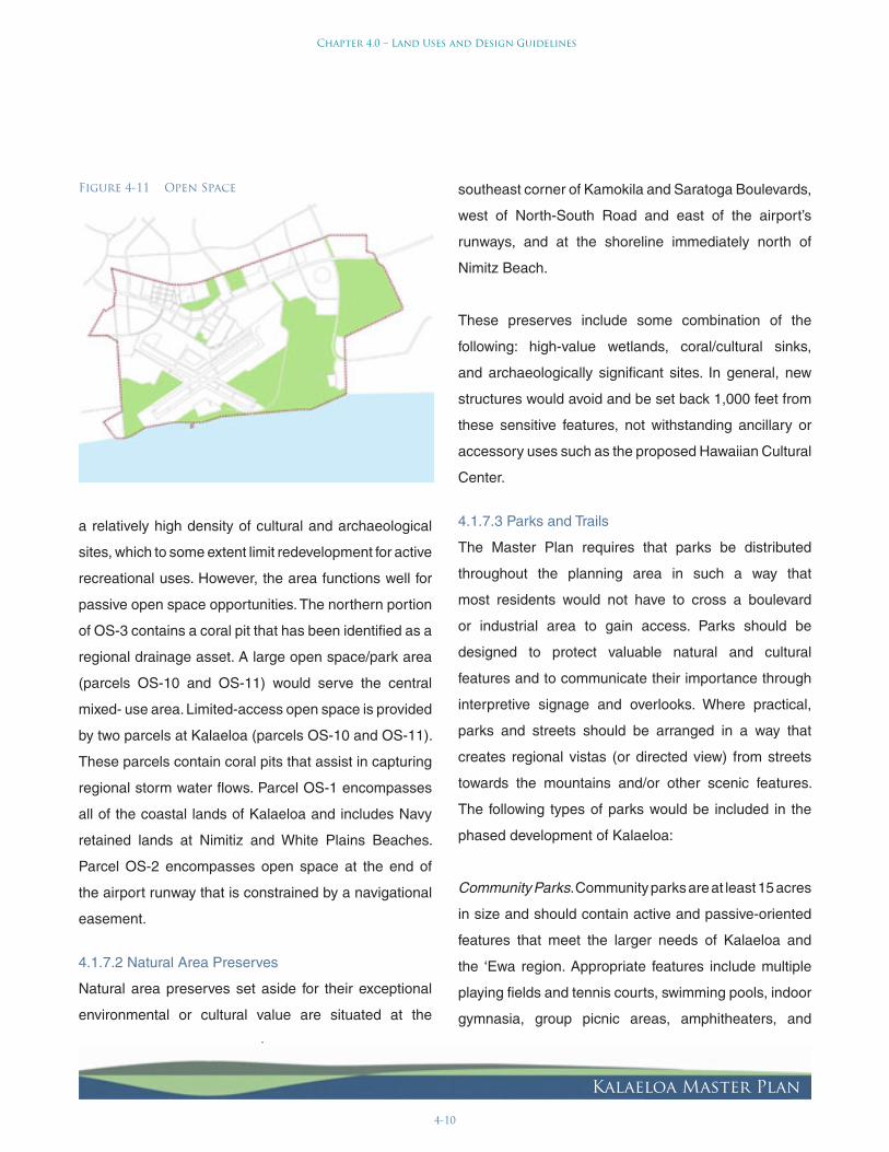
4-10
Chapter 4.0 – Land Uses and Design Guidelines
Kalaeloa Master Plan
a relatively high density of cultural and archaeological
sites, which to some extent limit redevelopment for active
recreational uses. However, the area functions well for
passive open space opportunities. The northern portion
of OS3 contains a coral pit that has been identified as a
regional drainage asset. A large open space/park area
(parcels OS10 and OS11) would serve the central
mixed use area. Limitedaccess open space is provided
by two parcels at Kalaeloa (parcels OS10 and OS11).
These parcels contain coral pits that assist in capturing
regional storm water flows. Parcel OS1 encompasses
all of the coastal lands of Kalaeloa and includes Navy
retained lands at Nimitiz and White Plains Beaches.
Parcel OS2 encompasses open space at the end of
the airport runway that is constrained by a navigational
easement.
4.1.7.2 Natural Area Preserves
Natural area preserves set aside for their exceptional
environmental or cultural value are situated at the
southeast corner of Kamokila and Saratoga Boulevards,
west of NorthSouth Road and east of the airport’s
runways, and at the shoreline immediately north of
Nimitz Beach.
These preserves include some combination of the
following: highvalue wetlands, coral/cultural sinks,
and archaeologically significant sites. In general, new
structures would avoid and be set back 1,000 feet from
these sensitive features, not withstanding ancillary or
accessory uses such as the proposed Hawaiian Cultural
Center.
4.1.7.3 Parks and Trails
The Master Plan requires that parks be distributed
throughout the planning area in such a way that
most residents would not have to cross a boulevard
or industrial area to gain access. Parks should be
designed to protect valuable natural and cultural
features and to communicate their importance through
interpretive signage and overlooks. Where practical,
parks and streets should be arranged in a way that
creates regional vistas (or directed view) from streets
towards the mountains and/or other scenic features.
The following types of parks would be included in the
phased development of Kalaeloa:
Community Parks. Community parks are at least 15 acres
in size and should contain active and passiveoriented
features that meet the larger needs of Kalaeloa and
the ÿEwa region. Appropriate features include multiple
playing fields and tennis courts, swimming pools, indoor
gymnasia, group picnic areas, amphitheaters, and
Figure 4-11 Open Space

4-11
Chapter 4.0 – Land Uses and Design Guidelines
Kalaeloa Master Plan
unique play structures. Features requiring floodlights or
prone to a high level of noise should be sited away from
residential uses. The proposed elementary school and
adjacent community park complex between Saratoga
Road and Roosevelt Avenue represent a jointuse
opportunity.
Neighborhood Parks, Pocket Parks, and Plazas. These
types of parks meet the “Community Open Space”
requirements noted in the mixeduse guidelines (see
Appendix D). Mixeduse areas bounded by boulevards
and/or avenues should contain one neighborhood park.
Neighborhood parks are between two and eight acres
and should include a playfield or multipurpose lawn
suitable for “pickup” soccer or softball, as well as play
equipment for small children and nearby picnic tables.
Pocket parks, between onehalf and two acres, can be
distributed throughout neighborhoods more easily to
bring recreation closer to each resident. Plazas can also
meet Community Open Space acreage requirements,
providing shaded hardscapes with seating and other
passive recreation opportunities.
Parkways and Trails. Parkways are depicted on the
land use plan along the east edge of NorthSouth Road
and along the eastern edge of the avenue that ends
at the northwest corner of the cultural park. Parkway
programming and landscaping should occur in concert
with the design of adjacent parcels.
4.1.8 Land Use Overlays
Overlays have been described in the plan where
conveyance and ultimate use is still under negotiation,
and to aid implementation of the Kalaeloa Design
Guidelines.
4.1.8.1 EcoIndustrial (Open Space Overlay)
Parcels 1G, 1H and 2A were previously designated as
regional open space, and there remains a potential that
all or part of these parcels may be accepted by the City
and County of Honolulu for use as a regional park. The
plan accommodates this potential.
4.1.8.2 Airport Related (MixedUse Overlay)
Parcels 1R, 2M and 3F include are designated as airport
related. In order to develop a uniform street frontage
along Saratoga Road, MixedUse Design Guidelines
should be used where development is adjacent to
Saratoga Road.
4.1.8.3 Recreational (EcoIndustrial Overlay)
Parcel 2L is owned by DHHL and they have been in
discussions with a private developer for the establishment
of a motor sports complex within the parcel. However,
the outcome of these discussions is uncertain and an
alternative ecoindustrial use can be accommodated in
the plan.

4-12
Chapter 4.0 – Land Uses and Design Guidelines
Kalaeloa Master Plan
4.2 Design Guidelines
The “Kalaeloa Design Guidelines” presented in Appendix
D are intended to foster a vibrant urban center built upon
a lively mix of residential and commercial uses. These
guidelines set careful and coherent controls on building
form, while employing more flexible parameters relative
to building use and density. This greater emphasis on
physical form will produce safe, attractive, and enjoyable
public spaces (good streets, neighborhoods, and parks),
complemented with a healthy mix of uses.
The Kalaeloa Design Guidelines are comprised of the
following components: (1) Urban Design Framework,
which consists of Street and Landscape Design
Guidelines; and (2) Site Development Guidelines,
consisting of MixedUse, and Industrial Development
Guidelines. These components are summarized below
and detailed in Appendix D.
4.2.1 Urban Design Framework
The Urban Design Framework for the Kalaeloa Master
Plan area is comprised of a set of design principles
to: (1) enhance the quality of design and construction
of all public areas; and (2) provide overall guidance in
executing a consistent yet dynamic design of all public
areas.
4.2.1.1 Street Design Guidelines
The Street Design Guidelines seek to create streets
that are pedestrian and bicycle friendly, while also
meeting the demands of motorists and emergency
vehicles. Walkable districts are the basic building block
for more livable and environmentally sustainable cities.
An arrangement of complementary land uses paired
with inviting streets influence the extent to which people
walk to local destinations and use transit. Pedestrian
friendly streets are foundational to transitoriented
development and the creation of alternatives to driving
for daily needs.
In deciding to walk or bike instead of drive, pedestrians
and bicyclists must feel that an environment is safe and
comfortable. Fast, unmitigated traffic presents a major
deterrent. Serious pedestrian and bicycle injuries are
significantly reduced when vehicle speeds are about 25
miles per hour. The use of modest travel lane widths
and trafficcalming devices slows traffic, while adding
very little to motorist travel times.
Pedestrians also feel more comfortable when onstreet
parking and trees are placed between roadways and
sidewalks, and when street crossing distances are
reduced. Street trees reduce temperatures by as much
as ten degrees — an important advantage on hot days.
Onstreet parking is critical to attracting streetfacing
shops.
Pedestrian comfort and safety are influenced by the
relationship between abutting uses and streets. Streets
lined by rear yard fences, garage doors, or parking
lots are unwelcoming, and have been shown to attract
more crime than streets lined by building entries and
windows. Traffic must be kept to modest volumes yet
encourage streetfacing buildings in most settings. An
interconnected street network plays a critical role in

4-13
Chapter 4.0 – Land Uses and Design Guidelines
Kalaeloa Master Plan
keeping traffic volumes to appropriate levels. Street
connectivity also reduces pedestrian travel distances
to local destinations, and integrates the many functions
and activities of a city center.
Besides mobility, streets can also address other issues.
Their design character — width, landscaping, lighting,
and signage — can help establish an immediate
sense of place, especially when joined with quality
architecture. Streets also hold most public utilities.
Paired with vegetated swales and other storm water
infiltration tools, streets can play an essential role in
filtering pollutants from urban runoff and improving
water quality. The design and arrangement of streets
are at the intersection of many urban challenges.
The Street Design Guidelines establish parameters for
the subdivision of bulk lots for the developers of those
parcels. Specifically, the Street Design Guidelines
describe articulation of the street network, street
connectivity, block sizes, and specific street design
elements with the goal of establishing a uniform public
realm that will become identifiable as Kalaeloa.
4.2.1.2 Landscape Design Guidelines
The Landscape Design Guidelines are intended as
a framework to maintain consistency of landscape
character throughout Kalaeloa, and provide a unifying,
engaging, and interesting element to public areas. The
design objectives are to:
• Achieve a compatible design character with
existing regional uses that reflect Kalaeloa’s
unique history as a Hawaiian historical and
cultural area and as a Naval Air Station.
• Promote a coherent vision of the future of
Kalaeloa as it evolves into a vibrant urban core.
• Develop a pedestrianoriented downtown area
that becomes a focal point for the community
and serves the needs of both residents and
daytime users.
• Enhance existing landscape patterns and
preserve existing trees by incorporating them
into the design of public areas and development
parcels.
The Landscape Design Guidelines will also guide
the landscape design of individual bulk lots and open
space areas. They seek to clearly describe the unifying
elements that will give Kalaeloa a distinctive image and
character, and address views, openspace planning
and design, plant selection, street furniture, lighting and
signage design. Sustainable design features are also
addressed.
4.2.2 Site Development Guidelines
The Site Development Guidelines for the Master Plan
include: (1) MixedUse Development Guidelines, (2)
Industrial Development Guidelines, and (3) Sustainable
Design Guidelines.
4.2.2.1 MixedUse Development Guidelines
The MixedUse Development Guidelines will ensure
critical dimensions for accomplishing a healthy and
attractive urban environment, while allowing enormous

4-14
Chapter 4.0 – Land Uses and Design Guidelines
Kalaeloa Master Plan
flexibility with regard to style and use. While many
features remain constant, specific guidelines distinguish
between the following: “MixedUse High Intensity”
where greater height and intensity is desirable because
of proximity to regional transit and to storefront
conveniences such as retail, professional offices, and
personal services; “MixedUse Moderate Intensity,”
where the flexibility and conveniences offered by
mixeduse development is desirable but at moderate
intensities; and “MixedUse AirportRelated” appropriate
for industrial and commercial uses that take advantage
of the airport as a unique opportunity.
The MixedUse Development Guidelines define allowable
land uses, critical elements of building planning and
design that will give Kalaeloa an identifiable architectural
character, and site development standards.
4.2.2.2 Industrial Development Guidelines
The Industrial Development Guidelines provide land
use, design, and site development standards for those
areas deemed appropriate for a range of industrial and
commercial activities. Industrial areas avoid exposing
residential areas to inappropriate risks and protect
against the loss of industrial jobs and activities. These
guidelines provide a high degree of flexibility, while also
enhancing the image and identity of Industrial areas.
4.2.2.3 Sustainable Design Guidelines
The Sustainable Design Guidelines promote active
inclusion of current and future bestpractices in all
site planning, building, and landscape design. Rather
than being prescriptive, this section addresses general
principles and elements to benefit both Kalaeloa as a
whole, as well as individual developments. Features
discussed include shading, heating and cooling
equipment, passive solar design, storm water disposal,
and alternative energy generation techniques that may
be used by individual developments.

5-1
Chapter 5.0 – Implementation
Kalaeloa Master Plan
5.0 IMPLEMENTATION
This chapter outlines five key components to the
successful implementation of the Kalaeloa Master Plan
(Master Plan): development phasing, infrastructure,
public services, financing, and governance. An additional
consideration for the implementation of the Master Plan
is the U.S. Navy’s possible reuse of portions of Kalaeloa
lands to support an aircraft carrier strike group at
Pearl Harbor. Discussion of this issue is contained in
Appendix F.
5.1 Development Phasing
Implementation of the Kalaeloa Master Plan is projected
to occur in three overlapping phases of approximately
seven years each through the year 2025. Development
is expected to continue beyond the 20-year planning
horizon, and this is discussed narratively but not
included in the cash-flow model analysis. The timing
of the development phases was established to reflect
the potential absorption of new development, the
evaluation of current regional economic conditions, and
projected future market opportunities. The locations for
each of the development phases were based largely
on the availability of land, the opportunity to integrate
development with other projects adjacent to Kalaeloa,
and the connections with regional infrastructure
systems. The overlapping of phases is intended to
provide flexibility in responding to the size and scope
of various development projects, as well as policy and
administrative changes over the development period.
Descriptions of the three development phases are
provided below.
5.1.1 Phase 1: 2007 to 2015
Phase I focuses upon the commencement of
infrastructure improvements to facilitate development.
Drainage and utility improvements will be installed as
street improvements are made, so that properties served
by the improved streets and drainage facilities will also
have water, sewer, power, and telecommunications
services available. Phase 1 also includes the start of the
realignment of Saratoga Road to provide for a transit
corridor and the broader implementation of the Master
Plan. (Refer to Figure 5-1)
Phase I includes land use improvements in the
northeastern and northwestern corners of the Kalaeloa
property. Beginning at the northeastern corner, Phase
I includes the initial development of a 79-acre light
industrial bulk lot (parcel 1A), 60 acres of Mixed-Use
Moderate Intensity development (parcels 1B, 1D, 1E,
1L, and a 12-acre portion of parcel 1F), approximately
116 acres of eco-industrial development at parcels
1G and 1H, and an elementary school site at parcel
1C. At the northwestern corner, Phase 1 includes light
industrial development on parcel 1M, the transit corridor
base yard (parcel 1Q), moderate and high intensity
mixed use along the western side of the Wakea Street
extension (parcel 1I), approximately 144 acres of eco-
industrial development at parcels 1N, 1O and 1P, and
a 30-acre airport-related industrial parcel (1R). The
specifics regarding the number and type of residential
units and floor area of commercial, office, and light
industrial space for Phase I are provided in Table 5-1.

5-2
Chapter 5.0 – Implementation
Kalaeloa Master Plan
It is anticipated that municipal water and sewer services
will initially be available in the vicinity of the northeastern
corner of Kalaeloa. The provision of these services to
this component of Phase 1 may require the construction
of connecting water and sewer pipelines across the
northern portion of Kalaeloa in advance of roadway
improvements or the construction of temporary facilities
to serve the northwestern component of Phase 1.
5.1.2 Phase 2: 2012 to 2020
Phase 2 focuses on infilling mixed-use development
between Phase 1 development areas, including
completion of the Saratoga Road realignment and
surrounding open space, parks, and middle school. It also
includes expansion of the eco-industrial development at
the east end of the airport runway and expansion of
airport-related uses south of Saratoga. The extension
of the North-South Road connection to Ocean Pointe
would also be completed. Major components of new
roadway, drainage, and utility infrastructure would be
completed during Phase 2. The specifics regarding the
number and type of residential units and floor area of
commercial, office, and light industrial space for Phase
2 are provided in Table 5-1. (Refer to Figure 5-2)
5.1.3 Phase 3: 2015 to 2025
Phase 3 focuses on continuing the infill of mixed-use
development along the central portion of the realigned
Saratoga Road and completion of the great park (parcel
3F). Phase 3 also includes development of the Hawaiian
Cultural Center on parcels 3B and 3C and an adjacent
mixed-use development on parcel 3A. Minor components
of new infrastructure, extending from major backbone
components constructed in Phases 1 and 2, would be
installed during Phase 3. The specifics regarding the
number and type of residential units and floor area of
commercial, office, and light industrial space for Phase 3
are provided in Table 5-1. (Refer to Figure 5-3)
5.1.4 Beyond 2025
Infill development would be completed along Saratoga
Road, especially on the south side. It is assumed that
existing housing in parcels 4A, 4B, and 4C would be
redeveloped to replace units that will be over 40 years
old by 2025. (Refer to Figure 5-4)
Table 5-1: Development Phasing Summary
Development Phasing Summary
Use Phase 1 Phase 2 Phase 3 Total Project
Residential – dwelling units 2,636 2,204 1,512 6,352
Commercial – square feet 116,583 0 0 116,583
Office – square feet 195,203 244,698 285,127 725,028
Light Industrial – square feet 683,211 728,394 407,783 1,819,388
Light Industrial Mixed Use – square feet 0 257,080 213,356 470,436
Source: BAE, 2005.
Table 5-1 Development Phasing Summary

Kalaeloa Master Plan
Figure 5-1 Kalaeloa Master Plan PHASE 1:2007 to 2015

Kalaeloa Master Plan
Figure 5-2 Kalaeloa Master Plan PHASE 2: 2012 to 2020

Kalaeloa Master Plan
Figure 5-3 Kalaeloa Master Plan PHASE 3: 2015 to 2025

Kalaeloa Master Plan
Figure 5-4 Kalaeloa Master Plan Beyond 2025

5-7
Chapter 5.0 – Implementation
Kalaeloa Master Plan
5.2 Infrastructure
5.2.1 Public Dedication
The Master Plan anticipates that all future utility systems
at Kalaeloa will be operated by local utility providers
such as HECO, BWS, City Department of Environmental
Services, Hawaiian Telcom, and others. Roads,
drainage, water supply, and wastewater systems that are
constructed will need to be designed to City standards
as they will ultimately be conveyed to the City.
5.2.2 Roadways
City standards call for a 50-foot right-of-way (ROW)
for minor streets and cul-de-sacs, a 60-foot ROW for
business/industrial/collector streets, and a 120-foot
ROW for boulevards. However, on a case-by-case basis,
some of the business/industrial/collector streets may
be required to have either a 74-foot or 78-foot ROW,
and boulevards may be required to have a ROW width
between 124-feet to 128-feet. It should be noted that
existing ROWs at Kalaeloa conveyed to the City do not
conform to these City standards, and thus transfer of
additional land to the City to expand the ROWs would
be required. City personnel have proposed that New
Saratoga Road (Geiger Road to Malakole Street) be a
boulevard. The North-South Road, a major connection
to H-1 and Kapolei Parkway, should also be a boulevard
for its full length (from the northern boundary to Ocean
Pointe). In accordance with City ordinance, traffic impact
fees would be assessed on developers within Kalaeloa
to provide regional transportation improvements.
5.2.3 Drainage
Managing drainage during implementation of the Master
Plan is two-fold: regional drainage from the mauka
watershed that flows into Kalaeloa and run-off within
Kalaeloa.
An analysis of the existing regional drainage channel
and the box culverts that discharge into the coral pit near
the intersection of Fort Barrette Road and Franklin D.
Roosevelt Road conclude it is inadequate to handle
runoff from a modeled 100-year storm event. Not only
do the existing box culverts limit flow into the coral pit
(causing flooding over the railway alignment and onto
Franklin D. Roosevelt Road during extreme precipitation
events), but the infiltration capacity of the coral pit is
inadequate to handle the peak flow of a 100-year event.
Given this situation, it is recommended that the HCDA
engage in discussions with the City and affected land
owners and developers to propose a solution to manage
regional drainage.
Within Kalaeloa, existing drywells installed by the U.S.
Navy, although permitted by the State Department
of Health, do not conform to City standards. It is
recommended that HCDA pursue with the City the
establishment of a special drainage district within
Kalaeloa to allow the use of drywells, swales, and
retention basins for disposal of drainage within City and
State rights-of-way.

5-8
Chapter 5.0 – Implementation
Kalaeloa Master Plan
5.2.4 Water
Development of a water system in accordance with
the Honolulu BWS standards will be required for
implementation of the Master Plan. Major components
of the system will include source, storage, and
transmission. Source can be provided by development
of wells for dedication to the BWS, or by payment of
source fees, if agreed to by the BWS. Storage will require
siting and construction of a new 215-foot elevation 5.0-
MG (million gallon) reservoir to handle the demand
projected for implementation of this Master Plan. A
primary transmission main will be needed to transmit
water from the 215-foot reservoir to Kalaeloa. This main
could be installed in parallel to an existing water main
that is currently planned for installation along the North-
South Road alignment.
A water master plan will need to be submitted to the
BWS for approval prior to constructing the water system.
Water master plan approval may require a water system
that loops back to a large water main in Kapolei, either
along Kamokila Boulevard or Fort Barrette Road.
Looped water transmission systems are more reliable
and provide greater operational flexibility than systems
fed by a single main.
For water lines within Kalaeloa, it is proposed that
none of the existing Navy lines be incorporated into the
water system on a permanent basis, primarily because
these lines are about 50 years old and are generally
too small to service the planned densities. There will be
two primary east-west “backbone” water lines between
the North-South Road and Kamokila Boulevard, aligned
along Roosevelt Road and Saratoga Road. All lines
serving development of the northern half of Kalaeloa
will branch off of these backbone lines. There will also
be a loop line that runs approximately along the eastern,
southern, and western property lines.
Developers at Kalaeloa will be required to pay BWS
facility charges prior to connecting to the water system.
The BWS will also award “credits” to HCDA for water
infrastructure improvement expenditures.
For existing Kalaeloa developments that disconnect from
the Navy water system and connect to the proposed
BWS system, either master meters or individual building
meters could be installed, depending on the situation. If
master meters are used, the owner of the system served
by the meter would be responsible for billing individual
users and paying the BWS for water supplied through
the master meter.
A dual water system within Kalaeloa will need to be
constructed to provide non-potable water for irrigation
of parks and other common landscaped areas. The
details of this system will be described as part of the
water master plan.
5.2.5 Sewer
Within Kalaeloa, much of the existing sewer system will
have to be replaced to handle the proposed densities
and new roadway alignments and development areas.
Also, in some of the proposed development areas, sewer

5-9
Chapter 5.0 – Implementation
Kalaeloa Master Plan
lines do not exist. Further, most of the existing sewer
lines are not aligned in accordance with the proposed
roadway alignments.
A sewer master plan will need to be submitted to the
City for approval. In general, a major collector sewer will
run along the northern edge of the runway to a proposed
new master pumping station to the east, which will pump
sewage to the Honouliuli Wastewater Treatment Plant.
A southwestern pumping station will not be required;
the cost of collection and transport for Parcel 2N will be
borne by the DHHL.
Similarly, a new south pumping station will not be
required; the existing south pumping station is to remain
in service, because no additional loads are planned to
be added to this pumping station. The developers or
owners of parcels 2L, 3B, and 3C will have to provide
pumping stations to transport sewage to the proposed
new master east pumping station.
The proposed new master east pumping station would
be designed in accordance with City standards, which
require a large concrete dry pit for housing the pumps, a
vertical building over the pit for ancillary equipment, and
a separate room to house a standby generator.
Developers at Kalaeloa will be assessed sewer facility
charges by the City for offsite wastewater transport,
treatment, and disposal. Therefore, it is recommended
that a sewer master plan be prepared and submitted to
the City for approval.
5.2.6 Electrical
Given the scope of the Master Plan, the existing
electrical system in Kalaeloa will need to be upgraded.
An agreement with HECO is recommended to assure
that improvements to the electrical distribution system
serve the increased development in Kalaeloa. As the
detailed planning for each development project occurs,
specific power requirements will be identified that can
allow HECO to determine the work required to provide
electrical service. An installation charge for necessary
improvements and service will be assessed to the
developer of each parcel.
5.3 Public Services
Public services, including police, fire, emergency
medical, and other typical municipal services, are
currently limited at Kalaeloa and divided between
the City and the U.S. Navy, largely because the land
conveyance process from the Navy to other entities
has not yet been completed. This overlap in jurisdiction
and ambiguity in land ownership creates difficulties
in responding to public safety incidents and providing
necessary municipal services. The situation needs to
be resolved prior to the commencement of large-scale
new development.
The preparation of a fiscal impact study is recommended
as a near-term implementation action to identify public
services that are needed pursuant to the Master Plan
in both the near- and long-term, sources and amounts
of property tax and other public revenues, and any
resulting fiscal gap.

5-10
Chapter 5.0 – Implementation
Kalaeloa Master Plan
5.4 Financing
In the implementation of the Master Plan, private
developers will finance new development and public
agencies will finance new improvements on their
lands. The remaining piece of needed financing is for
construction of new infrastructure and utility systems
to serve public and private sector developments. The
estimated cost for this new infrastructure, based on
the cash flow model described below, is approximately
$470,000,000, including all needed improvements within
Kalaeloa and external to Kalaeloa. This value includes
water, sewer, and traffic impact fees (facilities charges)
of approximately $281,000,000, but does not account for
potential credits that may be awarded for construction
of water and sewer system facilities. This value also
does not include electrical or telecommunications
improvements, because these services would be
provided by private companies with whom any charges
for capital improvements related to system expansion
into Kalaeloa are negotiable.
5.4.1 Feasibility Analysis
A detailed 20-year cash flow model of the Master Plan
was prepared in order to assess its financial feasibility.
The model consists of a linked series of spreadsheets
that shows the potential build-out of various types of
residential and commercial real estate, sale prices and
the value of completed projects, and total development
costs, including impact fees and other required
developer contributions. The model allows the testing of
various alternative assumptions, as well as identification
of the impacts of changes in major assumptions, such
as sale prices, interest rates, or construction costs. An
important purpose of the model is to determine whether
proposed development is feasible, or if there are any
“feasibility gaps” that require public assistance before
new development can occur. The details of the cash
flow model are contained in Appendix C.
The model is based on current market prices and
rents for residential, commercial, office, and industrial
buildings in the Kapolei area. No increases in prices
are projected over the life of the Master Plan in order
to avoid overstatement of potential revenues. The
model assumes that at least 30 percent of all new
residential units will be affordable, as set forth in the
City’s affordable housing rules. The potential cost for
developer purchases of parcels in Kalaeloa is included
in the model. The model also includes all required impact
fees and assessments for new utilities, as well as those
required under the ÿEwa Regional Transportation Plan.
Construction costs, based on local estimates, include
all hard costs as well as soft costs for architecture,
engineering, project finance, and developer profit.
Costs for a new “backbone” infrastructure system to
serve parcels in the new development area of Kalaeloa
are included.
Table 5-2 summarizes the results of the cash flow model
analysis of the Master Plan:

5-11
Chapter 5.0 – Implementation
Kalaeloa Master Plan
Highlights from the analysis are as follows:
• Total development cost is estimated at
$3.3 billion over three phases spanning a 20-
year-plus period.
• Based on current market values and required
developer returns, there is an approximate
$221 million “feasibility gap,” whereby the value
of completed development is less than the
cost to build it. Unless addressed, this will limit
developer interest.
Table 5-2 Summary of Kalaeloa Master Plan Development Revenues, Costs, Feasibility GapTable 1: Summary of Kalaeloa Master Plan Development Revenues, Costs, Feasibility Gap
Phase 1 Phase 2 Phase 3 Total
REVENUES FROM DEVELOPMENT
Net Sale Proceeds ("Value")Residential 1,100,359,950$ 855,884,727$ 465,945,207$ 2,422,189,883$Commercial 76,510,042 52,295,120 60,935,319 189,740,481Industrial 92,323,009 148,852,483 96,951,932 338,127,424
Net Sale Proceeds 1,269,193,000$ 1,057,032,330$ 623,832,457$ 2,950,057,788$
Lease Revenues 61,392,269$ 70,791,004$ 48,615,466$ 180,798,739$
Total Revenues 1,330,585,269$ 1,127,823,334$ 672,447,924$ 3,130,856,527$
EXPENSES OF DEVELOPMENT
Development Costs (a) 1,348,301,041$ 1,082,497,338$ 703,235,931$ 3,134,034,310$
Return to Investors (b) 74,637,613 104,676,787 38,359,905 217,674,305
Total Costs 1,422,938,654$ 1,187,174,124$ 741,595,836$ 3,351,708,614$
"FEASIBILITY GAP" (c) (92,353,385)$ (59,350,790)$ (69,147,912)$ (220,852,088)$
(Revenues - Expenses)
(a) Includes land, all construction, and all infrastructure.(b) Return on equity needed to attract private investment.
Based on current market rates of return for real estate investment.(c) Represents the revenue shortfall needed to achieve feasibility,
without public / other support in this amount development will not happen.
Source: BAE, 2006.

5-12
Chapter 5.0 – Implementation
Kalaeloa Master Plan
The identification of a feasibility gap led to evaluation
of alternative financing tools to address this challenge.
Alternatives include grants, state-issued general
obligation bonds, Community Facilities District bonds
issued by developers, and Tax Increment Finance
bonds issued by the City (as described elsewhere in
this section). A description of these financial options is
provided below.
5.4.2 Grant Sources
The U.S. Department of Commerce’s Economic
Development Administration (EDA), through its Public
Works and Economic Development Facilities Assistance
Program, provides funds for infrastructure improvements
that promote economic development. Total EDA awards
at other former military bases show that bases which
attracted the most funding each received between $8
and $11 million.
Table 5-3 Summary of Kalaeloa Master Plan Public Finance Alternatives
Table 2: Summary of Kalaeloa Master Plan Proposed Public Financing Sources
Phase 1 Phase 2 Phase 3 Total
FEASIBILITY GAP (a) ($92,353,385) ($59,350,790) ($69,147,912) ($220,852,088)
PROPOSED FINANCING SOURCES
State Obtained Sources
Grant Funds (b) $15,000,000 $0 $0 $15,000,000State Gen'l Obligation Bonds (c) 86,250,000 69,000,000 80,500,000 235,750,000
Total Funds $101,250,000 $69,000,000 $80,500,000 $250,750,000
Note: Financing sources show larger amount than feasibility gap because of bond underwriting costsand reserve requirements.
(a) Amount by which total costs of development exceed revenues from completed projects. Negative number means costs exceed revenue, without public / other support project will not be built. Use of bond financing to close gap increases costs due to underwriting, bond reserve requirements.(b) Projected U.S. EDA, FAA bonds for infrastructure projects.(c) Requires approval by Legislature.
Source: BAE, 2006.

5-13
Chapter 5.0 – Implementation
Kalaeloa Master Plan
Another funding source is the FAA’s Military Airport
Program. This funding source is for military airfields
closed pursuant to the BRAC process. These funds can
be used for airfield improvements as well as utilities,
access roads, airside infrastructure improvements, or
other improvements that make the airport’s infrastructure
independent of other portions of the former base. This
is a significant funding source that can provide $7 to $10
million per year; however, its use would be limited to
those improvements directly benefiting Kalaeloa Airport.
Major roadways and improvements that support transit
use or alternative modes of transportation may be eligible
for other funding sources, particularly the pending
legislation in Congress to replace or reauthorize TEA-
21 funding. These funds are typically provided through
regional metropolitan planning organizations. HCDA will
work with the Oÿahu Metropolitan Planning Organization
to secure available funds.
No other state grant sources are assumed to be available
for Kalaeloa infrastructure improvements.
5.4.3 Bond Financing
The remaining cost of infrastructure improvements
will need to be financed through bond issuances that,
depending upon the type of bond, will be repaid either
from assessments on property owners or new tax
revenues generated by new development at Kalaeloa.
A range of bond tools can be used, but since repayment
is based on new development, their use will be limited
to infrastructure serving the new development enclave.
Financing for infrastructure improvements in lands
owned by public agencies could be accomplished
through state-issued general obligation bonds.
5.4.4 Hawaiÿi Community Development Authority Special Assessment Bonds
HCDA, subject to authorization by the Legislature, may
issue and sell bonds to provide funds to finance public
facilities that are backed by assessment on benefitting
landowners. The salability of these bonds would likely
be based upon the bond market’s confidence that the
landowners directly affected by the improvements would
be able cover bond payments, regardless of the timing
of new development.
5.4.5 Community Facilities District Bonds
The State has provided counties with the authority to
issue Community Facilities District bonds that can be
used to finance infrastructure improvements (HRS
§46-80.1). Community Facilities District bonds are paid
through assessments on future property owners and
are thus backed by the property rather than the City.
Community Facilities District bonds also require that the
financed improvements be dedicated to the City.
One limitation of Community Facilities District bonds is
that they tend to slightly reduce the sale prices and value
of new development, in order to offset the additional
assessments that property owners must pay. These
bonds are backed by the bond market’s confidence
in market conditions and the proposed development
project, and thus may not be saleable until developers
are selected.

5-14
Chapter 5.0 – Implementation
Kalaeloa Master Plan
5.4.6 Tax Increment Finance Bonds
The State has authorized counties to issue Tax
Increment Finance bonds that can be used to finance
infrastructure improvements (HRS §46-101 et. seq.).
A tax increment district is first established for an area
to be redeveloped. As new development occurs, the
incremental additions in property tax revenues that are
generated (after deducting the costs of needed new
municipal services such as public safety, public works,
etc.) can be used to finance bonds.
This technique does not result in an increase in property
tax rates, nor does it impact activities that are currently
funded by existing property tax revenues in the tax
increment district. Because Tax Increment Finance
bonds are repaid from property taxes that new property
owners have to pay, there is no potential impact on
property values as there is with Community Facilities
District financing.
The limitation of Tax Increment Finance bonds is that
there must be an existing tax increment flow to finance
bonds. This means that Tax Increment Finance bonds
could not be used until Phase 2 or later in Kalaeloa’s
development.
5.4.7 Caveats and Limitations
The information used for the feasibility analysis is based
on current market information. It should be considered
illustrative rather than definitive. Financial analysis
addresses whether development can profitably occur,
but does not address whether there is sufficient market
demand to sell or lease the proposed project.
Markets are dynamic, and a plan with a 20-year
timeframe will experience multiple economic cycles.
Interest rates, sales prices and lease rates, material
costs, and other parameters will vary greatly during
future economic cycles, and have a profound impact
on project feasibility. Evaluation of project feasibility will
need to occur throughout implementation of the Master
Plan, and the eventual amount of any feasibility gap at
any particular time may vary significantly from what has
been projected here.
Cost assumptions, including those for land, infrastructure,
and construction, are conceptual in nature. As further
planning and development occurs, these costs may
increase or decrease significantly from what has been
modeled to date. More detailed implementation planning,
with supporting financial analysis, will be needed.

5-15
Chapter 5.0 – Implementation
Kalaeloa Master Plan
5.5 Governance
At present, there are at least 16 public agencies and
two private entities at Kalaeloa that either own land or
are designated to receive land once the base closure
conveyance process has been completed. In base
reuse efforts that involve multiple jurisdictions, having
an effective governing authority and an efficient process
for decision making that can bind all participants is
essential for the success of the redevelopment effort.
Through its statutory authority, HCDA has the ability to
accelerate reuse through development entitlements,
pursue the issuance of bonds to finance improvements,
and assessment of properties as needed to fund
Kalaeloa’s management. As the successor to the former
Local Reuse Authority (Barbers Point NAS Reuse
Commission); HCDA has standing to work with the U.S.
Navy on remaining base reuse issues.
However, given the multi-jurisdictional nature of
Kalaeloa, HCDA cannot solely rely upon its statutory
authority but must develop the capacity to coordinate
with the various entities within Kalaeloa in manner that
can facilitate implementation of the Master Plan. There
are several ways in which this coordination can occur
that involve varying degrees of formality.
At the most informal level, agency-to-agency contact
through meetings and written correspondence on a
frequent basis can address many of the coordination
issues involved in development planning and project
implementation.
When specific property maintenance or development
agreements are necessary, more formal means
of coordination are required. Depending upon the
circumstances, a formal MOA or contract between
parties may be warranted and can be negotiated in such
a manner that conditions of the agreement are binding
upon the parties.
The third, and most formal, mechanism for coordination
is through the enactment of legislation. Depending
upon the circumstances and the parties involved,
legislation could be sought at the federal, state, or city
level. Legislation needs to be considered when seeking
funding, specific actions that cannot be accomplished
through other less formal means, or structural changes
in the authority or relationships between parties. Since
such actions are subject to public debate and policy
making, uncertainties exist in final content and ultimate
passage Further, the timing required for the passage of
legislation may adversely impact development phasing
and implementation.

5-16
Chapter 5.0 – Implementation
Kalaeloa Master Plan

B-1
Bibliography
Kalaeloa Master Plan
_________. 1997. Final Reuse Plan and Homeless Assistance Application, Appendices. Prepared for Barbers Point Naval Air Station.
_________. 1998. Kalaeloa Airport Master Plan.
_________. 1999. Final Environmental Impact Statement for Developing Home Port Facilities for Three NIMITZ-Class Aircraft Carriers in Support of the U.S. Pacific Fleet.
_________. 1999. Final Environmental Impact Statement for the Proposed Closure and Reuse of Naval Air Station Barbers Point. Hawaii. Prepared for Barbers Point Naval Air Station.
_________. 2002. Ford Island Development Final Programmatic Environmental Impact Statement, Volume I. Pearl Harbor, Hawaiÿi. Prepared for the Department of the Navy.
_________. 2002. Ford Island Development Final Programmatic Environmental Impact Statement, Volume II: Appendices. Pearl Harbor, Hawaiÿi. Prepared for the Department of the Navy.
Aries Consultants LTD in association with Planning Solutions, Inc., Belt Collins Hawaii, Y. Ebisu & Associates. 1998. Kalaeloa Master Airport Master Plan. Prepared for State of Hawaii Department of Transportation Airports Division.
Barbers Point Naval Air Station Redevelopment Commission. 2001. Kalaeloa Community Redevelopment Plan Revision and Status Report.
City and County of Honolulu Planning Department. 1996. Ewa Development Plan.
Final Report: Environment, Vegetation Change, and Early Human Settlement on the Ewa Plain: A Cultural Resource Inventory of Naval Air Station Barbers Point, Oahu, Hawaii Part III: Paleoenvironmental Investigations by Steven Athens et.al, August 1999.
Hawaiÿi Community Development Authority. 2005. Kalaeloa Strategic Plan 2005 – 2010.
Helber Hastert & Fee Planners. 1993. Kapolei Area Long Range Master Plan. Ewa, Oahu, Hawaii.
Helber Hastert & Fee, Planners. March 1997. Naval Air Station Barbers Point, Oahu, Hawaii, Community Development Plan. Prepared for the Barbers Point Naval Air Station Redevelopment Commission.
Prefinal Report, Phase II - Intensive Survey and Testing Naval Air Station Barbers Point by Constance O’Hare, Paul H. Rosendahl, Ph.D., Inc (PHRI), February 1996.
R.M. Towill Corporation. 1999. Naval Air Station Barbers Point Community Redevelopment Plan, Sewer Master Plan. Ewa, Oahu, Hawaii. Prepared for Barbers Point Redevelopment Commission.
R.M. Towill Corporation. 1999. Naval Air Station Barbers Point Community Redevelopment Plan, Roadway and Drainage Master Plan. Ewa, Oahu, Hawaii. Prepared for the Barbers Point Naval Air Station Redevelopment Commission.
R.M. Towill Corporation. 1999. Naval Air Station Barbers Point Community Redevelopment Plan, Water Master Plan. Ewa, Oahu, Hawaii. Prepared for Barbers Point Redevelopment Commission.
Bibliography

B-2
Bibliography
Kalaeloa Master Plan
R.M. Towill. December 2000. Kalaeloa Redevelopment Plan, A Special Area Plan of the Ewa Development Plan, Ewa, Oahu, Hawaii. Prepared for the Barbers Point Naval Air Station Redevelopment Commission.
Synthesis of Cultural Resource Studies of the Ewa Plain by H. David Tuggle and M.J. Tomonari-Tuggle, International Archaeological Research Institute, December 1997
Townscape, Inc. 2003. Kalaeloa Technology Park Phase 2 Feasibility Study Final Report. Prepared for Department of Hawaiian Home Lands.