Embed Size (px)
Citation preview

GALLUP
October 18, 2013
RECEIVED
OCT Z 3 Z013
NMED Hazardous Waste Bureau
JEJE Via Email and Certified Mail 7011 2970 0003 9281 8428, Return Receipt Requested
Mr. Carl Chavez New Mexico Oil Conservation Division 1220 South St. Francis Drive Santa Fe, New Mexico 87505
RE: HYDROCARBON RELEASE NOTIFICATION REPORT UPDATE WESTERN REFINING COMPANY, SOUTHWEST, INC., GALLUP REFINERY EPA ID # NMD000333211 AP-111
Dear Mr. Chavez:
Western Refining Southwest., Gallup Refinery ("Western") submits an update to our initial Hydrocarbo1"1 Release Notification Report (dated August 20, 2013). The following spill response actions have been taken to address a discovery of hydrocarbons found on the land surface to the west of crude tank T -102 and northwest of the marketing tanks (T1-T8), which was reported in Form C-141 on July 11, 2013. We are providing a copy of this report to the New Mexico Environment Department, Hazardous Waste Bureau (the "Bureau"), in satisfaction of the Bureau's requests in letters dated July 31, 2013 and August 14, 2013 for a written notification report describing all investigation and clean-up actions.
Actions Completed To-Date
As reported in the first Hydrocarbon Release Notification Report, a series of 14 excavations were completed in the area of the seep to the west Tank T-102. Six of the excavations were completed as temporary recovery sumps. The groundwater and any hydrocarbons that enter the sumps are removed with a vacuum truck and placed into the wastewater treatment system up-steam of the API Separator. The volume of total liquids (groundwater and hydrocarbons) recovered from June 26, 2013 through October 8, 2013 is estimated to be 85,000 gallons (Table 1 ). The initial material recovered was estimated to be 50% water and 50% hydrocarbon; however, the percentage of hydrocarbon reduced significantly over the first couple of weeks.
Efforts to identify the source of the hydrocarbons completed through August 20, 2013 were reported in the initial Hydrocarbon Release Notification Report. As discussed in the initial Hydrocarbon Release Notification Report, Western had planned to conduct additional leak detection surveys using methods such as Tracer Tight ® or HeliTek ®, but due to safety concerns these techniques could not be used within the subject area of the refinery. Since the August 201
h report, additional actions as described below have been conducted to identify the source(s) of the hydrocarbons:
1. Additional dye tracer tests were conducted on the process sewer system;
1
92 Giant Crossing Road, Gallup, New Mexico 87301 • 505 722-3833 • www.wnr.com
WNR IIIIIID NYSE.

2. Physical inspections of the process sewer system, including a completion of a camera survey identified a hole in the sewer line on the west side of the bundle cleaning pad;
3. Additional site inspections of aboveground equipment were conducted to identify any evidence of possible sources of the hydrocarbon;
4. Elevations of the ground level and top of casing were measured at the temporary well completions and sump locations; and
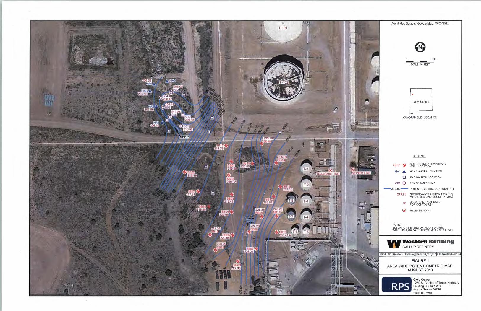
5. A potentiometric map and cross-sections of the shallow subsurface in the area of the temporary wells were prepared.
Two additional dye tests were conducted in the process sewer system. A yellow/green dye was introduced into the sewer at the transmix unloading area (a short distance northwest of the main product loading racks) on September 23, 2013 and a red dye was introduced at the lab sinks on September 24, 2013. A subsequent.fluid level gauging event was conducted at the temporary monitoring wells on September 26, 2013 (Table 2). The red dye has been identified in five of the temporary wells (SB01, SB02, SB16, SB17, and SB22), all of which are located just south of the road that runs east-west along the north side of the marketing tanks. The green/yellow dye appears to be present in nine wells (SB04, SB05, SB06, SB08, SB1 0, SB11, SB19, SB20, and SB21 ), which are all located toward the southern portion of the area that has been investigated to-date. Although the dye tests are not conclusive, the separate patterns of the two dyes suggest the possibility of two separate release areas from the sewer lines. The red dye appears to have exited the sewer line from a hole identified near the bundle cleaning pad (see discussion below). The source of the yellow/green dye is not currently known, but appears to be south of the hole recently identified in the sewer line.
A camera survey was conducted on multiple segments of the sewer line in the western portion of the refinery on August 27 and 28. Based on this visual inspection, a hole in the sewer line was identified approximately 20 feet south of the sewer box on the west side of the bundle cleaning pad. The location of the identified release point in the sewer line is shown on the enclosed potentiometric surface map (Figure 1).
On August 19 an operator inspecting aboveground equipment to identify any evidence of possible sources of the hydrocarbon seep, observed hydrocarbon on the land surface in the secondary containment east of tank T-3. The location of the leak, which is just west of the above ground pipeline rack that runs north to south along the east side of the marketing tank farm, is shown on Figure 1. Once the release was discovered, a small earthen containment berm was built approximately 10 ft to the west of the release. A sandpiper pump was then set up to transfer the hydrocarbon (approximately 1.5 barrels) to the process sewer. Operations were then able to isolate the underground pipeline that was leaking. The transmix/slop 6 to 8 inch pipeline is only used during the unloading of transmix trucks at the truck rack, thus it would only have been an intermittent source. Trucks are unloaded at the rack and this line transports the transmix/slop to T-231. The line was taken out of service, cleaned and blanked off. The line is being replaced with an aboveground pipeline.
The impacted soil was removed by Envirotech using hand shovels and placed into a roll-off box. Approximately 15 cubic yards were removed. Soil confirmation samples were collected from the bottom of the excavation and waste characterization samples were also collected during the
2

week of October 7, 2013. The soils remain on-site pending receipt of the waste characterization analyses.
As reported in our earlier August 20th report, waste characterization samples were collected from the soils generated during excavation for the sumps and the drill cuttings from the temporary well installations. The analyses demonstrated the soils were not characteristically hazardous, but did contain petroleum hydrocarbons. The soils from the initial excavations for the sumps and drill cuttings have been disposed off-site as hydrocarbon impacted soils.
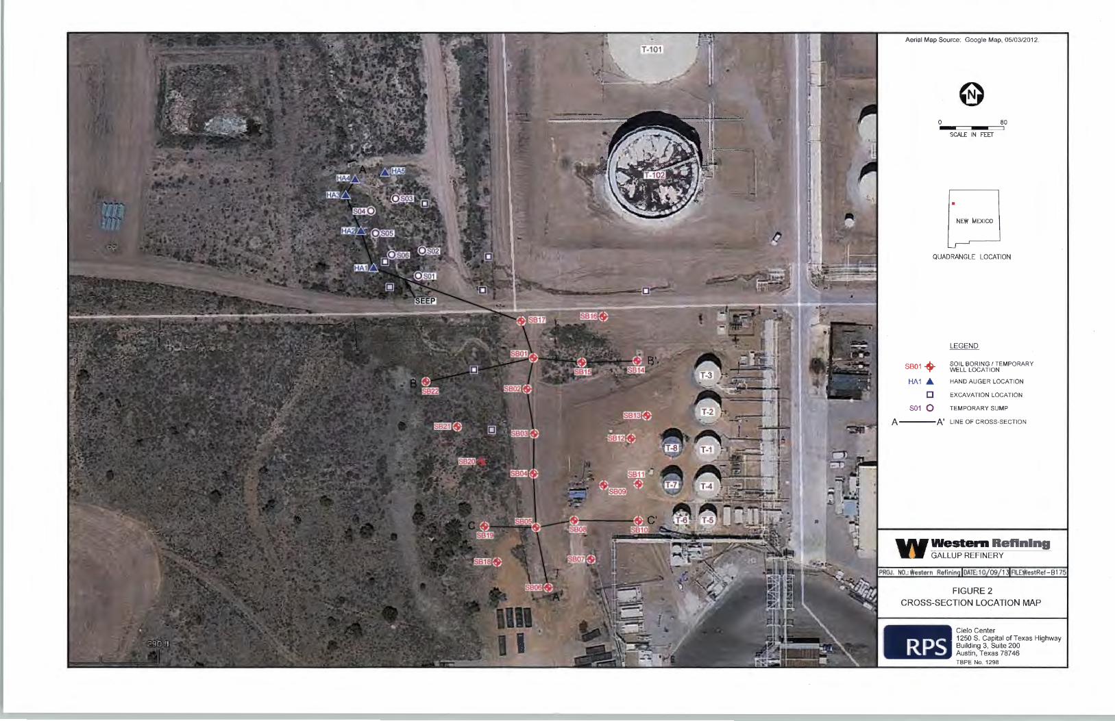
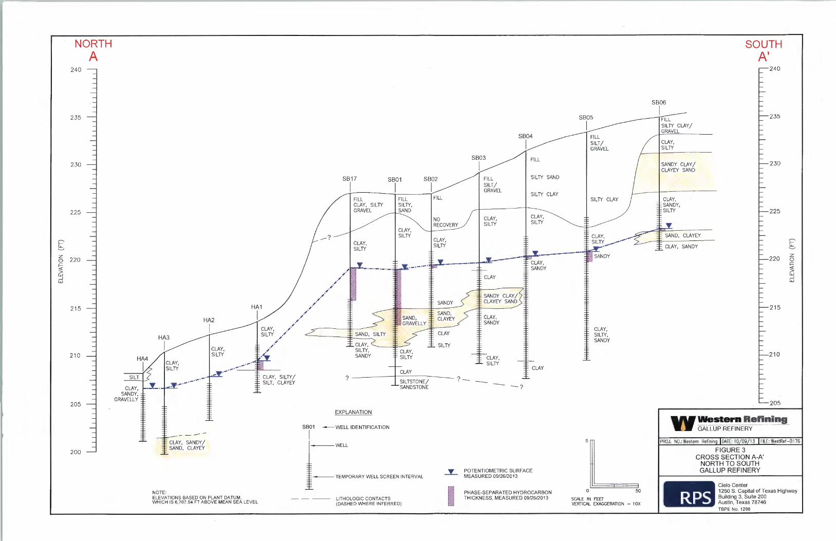
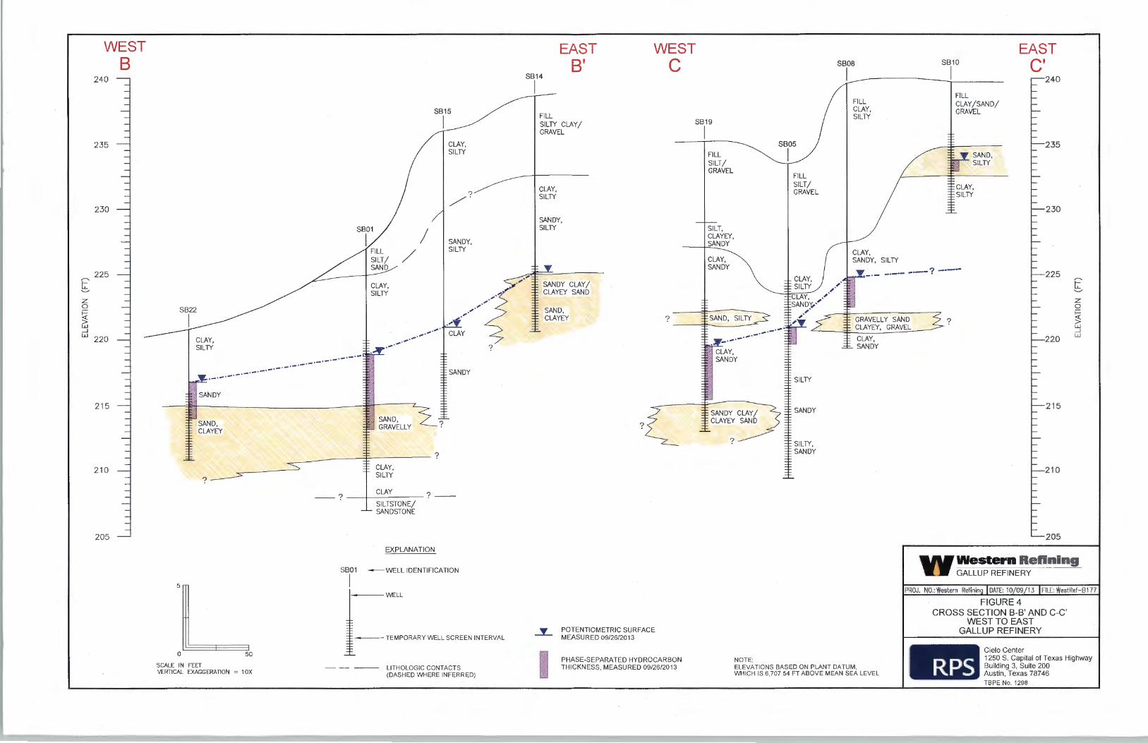
Using the new survey data for the temporary monitoring wells, a potentiometric surface map (Figure 1) and cross-sections (Figures 3 and 4) were prepared for the subject investigation area. The potentiometric surface mirrors the land surface topography and slopes to the northwest. Cross-section A-A' runs north-south and extends from the southernmost temporary well SB06 to hand auger location HA4, which is located near the discharge area to the northwest. Two west to east cross-sections B-B' and C-C' are included on Figure 4. All temporary wells appear to be completed in the same hydrogeologic unit, which varies from silty, clayey sand to sandy clay, with the exception of SB1 0. Temporary well SB1 0 is completed in a perched zone consisting of silty sand, which may be part of the fill material that is found to overlie native soils over much of the area. A saturated interval of fill composed of clay, sand, and gravel appears at a similar stratigraphic position in SB07 (boring logs provided in August 20th report); however, SB07 was completed in the deeper clayey sand interval that does appear to be in direct hydraulic communication with the other temporary wells. The perched zone appears to be of limited aerial extent and does not affect contaminant transport to the northwest as it terminates well short of the currently defined hydrocarbon plume.
In summary, two potential sources have been identified that could have resulted in the discharge of petroleum hydrocarbons at the land surface, as discovered on June 26, 2013. The hole in the sewer line on the west side of the bundle cleaning pad and the leak in the transmix/slop oil transfer line are within approximately 70 feet of each other and are hydraulically up-gradient of the seep area. Dye tests confirm the potential for materials released from the hole in the sewer line near the bundle cleaning pad to migrate to the area of the seep. Separate dye tests suggest the potential for another release point further south.
Future Actions
Western will continue efforts to further characterize potential source areas, to recover phaseseparated hydrocarbons (PSH) and to delineate the lateral extent of impacts to groundwater. These efforts will be accomplished by the following tasks.
• Sewer line repairs are currently underway. This will provide an opportunity to better examine the nature of the release identified west of the bundle cleaning pad. As possible, some overexcavation during the sewer line repair may be conducted to remove impacted soils. Upon completion of the repairs, potentially additional dye tracer tests will be conducted.
• A total of 26 temporary monitoring wells (22 soil borings and 4 hand-auger locations) were previously completed over a relatively small area west of the marketing tanks. A number of the temporary wells are in locations making them subject to damage due to normal refinery operations in this area. The temporary wells were reviewed based on thickness of higher transmissive sediments (e.g., sand vs. silty clay), measured thickness of phase-separated hydrocarbons, and position of surrounding wells to select wells to be plugged vs. recompleted as permanent monitoring wells. Ten of the 22 soil
3

boring temporary wells will be plugged and two of the four hand-auger borings will be plugged. The remaining 12 temporary wells will be recompleted as permanent monitoring wells and two of the hand-auger locations will be completed as permanent monitoring wells.
Approximately 12 additional temporary wells are planned in an effort to further define the lateral extent of groundwater impacts and to assess other potential sources to the southeast of the marketing tanks.
• Recovery operations at the six sumps will continue to remove any PSH and impacted groundwater that accumulates in the sumps.
If there are any questions regarding the actions taken to-date or planned further actions, then please contact me at 505-722-0217. Please note Western makes no admissions and reserves all applicable rights and defenses relevant to this matter.
Sincerely,
E~ Environmental Manager Western Refining Southwest, Inc. -Gallup Refinery
Enclosures
cc G. von Gonten, OCD without enclosure J. Kieling, NMED HWB with enclosure N. Dhawan, NMED HWB without enclosure T. Blaine, NMED without enclosure D. Cobrain, NMED HWB without enclosure K. Van Horn, NMED HWB with enclosure A Allen, Western El Paso
4
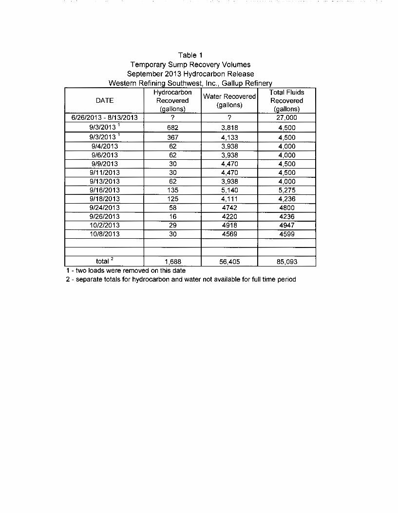
Table 1 Temporary Sump Recovery Volumes
September 2013 Hydrocarbon Release Western Refining Southwest, Inc., Gallup Refinery
Hydrocarbon Water Recovered
Total Fluids DATE Recovered
(gallons) Recovered
(gallons) (gallons) 6/26/2013- 8/13/2013 ? ? 27,000
9/3/2013 1 682 3,818 4,500 9/3/2013 1 367 4,133 4,500 9/4/2013 62 3,938 4,000 9/6/2013 62 3,938 4,000 9/9/2013 30 4,470 4,500
9/11/2013 30 4,470 4,500 9/13/2013 62 3,938 4,000 9/16/2013 135 5,140 5,275 9/18/2013 125 4,111 4,236 9/24/2013 58 4742 4800 9/26/2013 16 4220 4236 10/2/2013 29 4918 4947 10/8/2013 30 4569 4599
total 2 1,688 56,405 85,093 1 - two loads were removed on th1s date 2 - separate totals for hydrocarbon and water not available for full time period

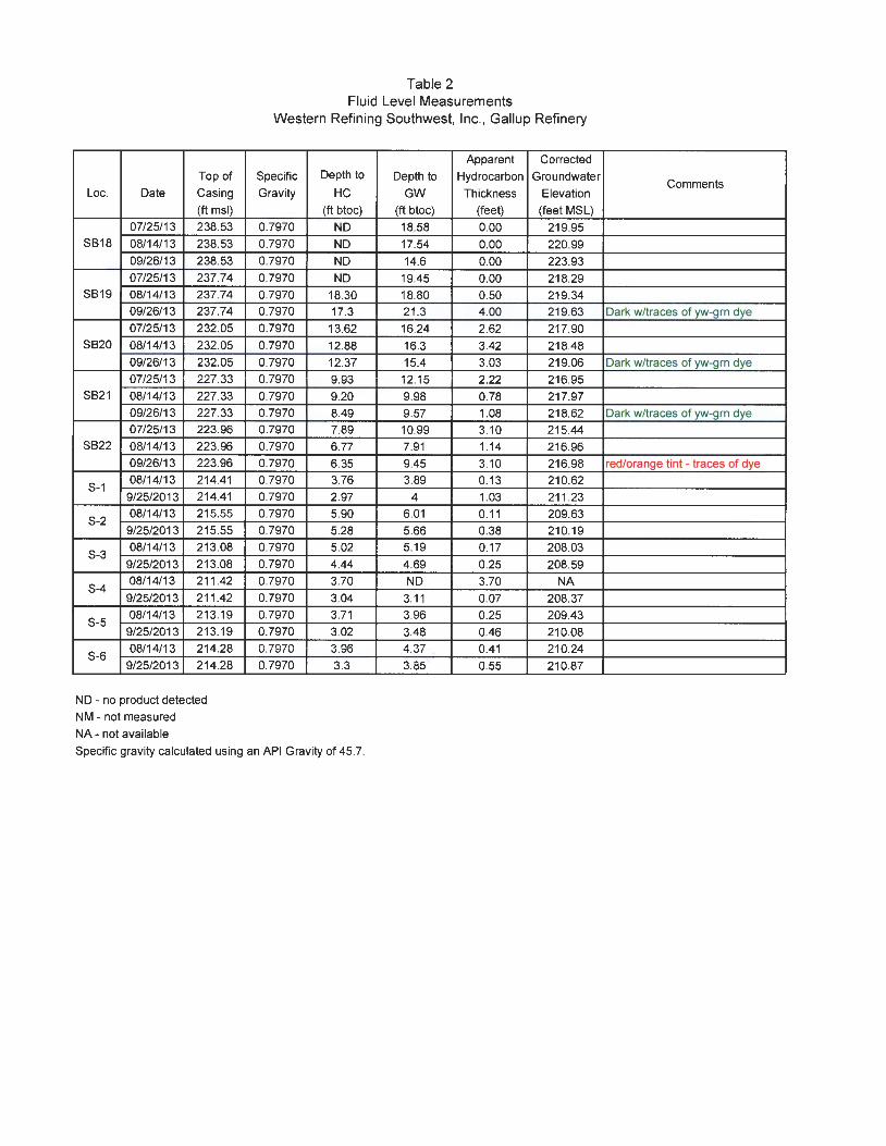
Table 2 Fluid Level Measurements
Western Refining Southwest, Inc., Gallup Refinery
Apparent Corrected
Top of Specific Depth to Depth to Hydrocarbon Groundwater Comments
Lac. Date Casing Gravity HC GW Thickness Elevation
(ft msl) (ft btoc) (ft btoc) (feet) (feet MSL)
07/11/13 215.38 0.7970 NO 6.60 0.00 208.78
07/12/13 215.38 0.7970 NO 6.60 0.00 208.78
HA1 07/17/13 215.38 0.7970 NO 6.80 0.00 208.58
08/14/13 215.38 0.7970 NO 9.19 0.00 206.19
09/25/13 215.38 0.7970 5.44 6.36 0.92 209.75 07/12/13 212.86 0.7970 NO 5.51 0.00 207.35
HA2 07/17/13 212.86 0.7970 NO 5.82 0.00 207.04
08/14/13 212.86 0.7970 NO 5.31 0.00 207.55
09/25/13 212.86 0.7970 NO 4.80 0.00 208.06 Clear - slight odor detected
07/12/13 210.84 0.7970 NO 6.40 0.00 204.44
HA3 07/17/13 210.84 0.7970 NO 6.68 0.00 204.16
08/14/13 210.84 0.7970 NO 4.28 0.00 206.56
09/25/13 210.84 0.7970 NO 4.01 0.00 206.83 Clear - slight odor detected
07/12/13 211 .26 0.7970 NO 6.41 0.00 204.85
HA4 07/17/13 211 .26 0.7970 NO 6.78 0.00 204.48
08/14/13 211 .26 0.7970 NO 4.94 0.00 206.32
09/26/13 211 .26 0.7970 NO 4.50 0.00 206.76 Clear - slight odor detected
HA5 07/12/13 NM 0.7970 NO 5.50 0.00 NA
07/17/13 NM 0.7970 NM NM NA NA well destroyed
07/17/13 229.84 0.7970 11.50 16.74 5.24 217.28
SB01 07/25/13 229.84 0.7970 10.85 16.55 5.70 217.83
08/14/13 229.84 0.7970 9.88 9.91 0.03 219.95 Has reddish tint - trace of dye?
09/26/13 229.84 0.7970 9.51 15.19 5.68 219.18 Red - dye - odor
07/17/13 227.85 0.7970 10.26 10.58 0.32 217.53
SB02 07/25/13 227.85 0.7970 9.68 9.97 0.29 218.11
08/14/13 227.85 0.7970 8.74 9.12 0.38 219.03
09/26/13 227.85 0.7970 8.25 8.45 0.20 219.56 red/orange tint - traces of dye
07/17/13 231.43 0.7970 NO 11.40 0.00 220.03
SB03 07/25/13 231.43 0.7970 NO 12.84 0.00 218.59
08/14/13 231.43 0.7970 NO 12.01 0.00 219.42
09/26/13 231.43 0.7970 NO 11.49 0.00 219.94 Clear - slight odor
07/17/13 232.24 0.7970 NO 13.62 0.00 218.62
SB04 07/25/13 232.24 0.7970 NO 12.98 0.00 219.26
08/14/13 232.24 0.7970 NO 12.19 0.00 220.05
09/26/13 232.24 0.7970 11 .72 11 .79 O.D? 220.51 Dark w/traces of yw-grn dye
07/17/13 234.52 0.7970 14.92 15.95 1.03 219.39
SB05 07/25/13 234.52 0.7970 14.48 15.40 0.92 219.85
08/14/13 234.52 0.7970 13.66 13.75 0.09 220.84
09/26/13 234.52 0.7970 13.2 14.25 1.05 221 .11 Dark w/traces of yw-grn dye
07/22/13 235.65 0.7970 14.10 14.11 0.01 221 .55
SB06 07/25/13 235.65 0.7970 14 14.01 0.01 221 .65
08/14/13 235.65 0.7970 NO 13.07 0.00 222.58
09/26/13 235.65 0.7970 12.19 12.4 0.21 223.42 Dark w/traces of yw-grn dye

Table 2 Fluid Level Measurements
Western Refining Southwest, Inc., Gallup Refinery
Apparent Corrected
Top of Specific Depth to Depth to Hydrocarbon Groundwater Comments
Loc. Date Casing Gravity HC GW Thickness Elevation
(ft msl) (ft btoc) (ft btoc) (feet) (feet MSL) 07/22/13 239.73 0.7970 14.84 14.85 0.01 224.89
SB07 07/25/13 239.73 0.7970 14.78 14.79 0.01 224.95 08/14/13 239.73 0.7970 NO 13.49 0.00 226.24
09/26/13 239.73 0.7970 NO 12.64 0.00 227.09 07/22/13 241 .29 0.7970 17.88 19.74 1.86 223.03
SB08 07/25/13 241 .29 0.7970 17.80 19.68 1.88 223.11 08/14/13 241 .29 0.7970 16.65 18.80 2.15 224.20 09/26/13 241 .29 0.7970 15.96 18.25 2.29 224.87 Dark w/traces of yw-grn dye 07/22/13 240.69 0.7970 16.64 16.65 0.01 224.05
SB09 07/25/13 240.69 0.7970 NO 16.65 0.00 224.04 08/14/13 240.69 0.7970 NO 14.83 0.00 225.86 09/26/13 240.69 0.7970 NM NM NA NA Bermed area full of water 07/22/13 241.30 0.7970 NO 8.29 0.00 233.01
SB10 07/25/13 241 .30 0.7970 NO 7.74 0.00 233.56 08/14/13 241 .30 0.7970 7.57 9.14 1.57 233.41 09/26/13 241 .30 0.7970 7.35 7.85 0.50 233.85 Dark w/traces of yw-grn dye 07/22/13 242.26 0.7970 NO NO 0.00 NA
SB11 07/25/13 242.26 0.7970 NM NM NA NA 08/14/13 242.26 0.7970 14.06 14.08 0.02 228.20 09/26/13 242.26 0.7970 13.23 13.45 0.22 228.99 Dark w/traces of yw-gm dye
07/22/13 241 .25 0.7970 14.13 14.14 0.01 227.12
SB12 07/25/13 241 .25 0.7970 NO 14.18 0.00 227.07 08/14/13 241 .25 0.7970 NO 14.72 0.00 226.53 09/26/13 241 .25 0.7970 NO 13.15 0.00 228.10 07/22/13 241 .85 0.7970 NO 15.21 0.00 226.64
SB13 07/25/13 241 .85 0.7970 NO 15.03 0.00 226.82
08/14/13 241.85 0.7970 NO 14.75 0.00 227.10
09/26/13 241 .85 0.7970 NO 13.65 0.00 228.20 07/25/13 240.79 0.7970 NO 16.09 0.00 224.70
SB14 08/14/13 240.79 0.7970 NO 15.70 0.00 225.09
09/26/13 240.79 0.7970 NO 15.25 0.00 225.54 07/25/13 239.04 0.7970 NO 19.46 0.00 219.58
SB15 08/14/13 239.04 0.7970 NO 18.54 0.00 220.50 09/26/13 239.04 0.7970 NO 17.83 0.00 221 .21
07/25/13 234.64 0.7970 11 .04 14.20 3.16 222.96 SB16 08/14/13 234.64 0.7970 10.76 11 .36 0.60 223.76 Has reddish tint - trace of dye?
09/26/13 234.64 0.7970 10.34 10.69 0.35 224.23 orange w/red tint - traces of dye 07/25/13 229.88 0.7970 12.00 12.13 0.13 217.85
SB17 08/14/13 229.88 0.7970 11 .09 11 .25 0.16 218.76
09/26/13 229.88 0.7970 9.79 13.02 3.23 219.43 orange w/red tint - traces of dye
Top of
Loc. Date Casing
(ft msl)
07/25/13 238.53 SB18 08/14/13 238.53
09/26/13 238.53
07/25/13 237.74 SB19 08/14/13 237.74
09/26/13 237.74
07/25/13 232.05 SB20 08/14/13 232.05
09/26/13 232.05
07/25/13 227.33 SB21 08/14/13 227.33
09/26/13 227.33
07/25/13 223.96 SB22 08/14/13 223.96
09/26/13 223.96
S-1 08/14/13 214.41
9/25/2013 214.41
S-2 08/14/13 215.55
9/25/2013 215.55
S-3 08/14/13 213.08
9/25/2013 213.08
S-4 08/14/13 211.42
9/25/2013 211.42
S-5 08/14/13 213.19
9/25/2013 213.19
S-6 08/14/13 214.28
9/25/2013 214.28
ND - no product detected
NM- not measured
NA - not available
Table 2 Fluid Level Measurements
Western Refining Southwest, Inc., Gallup Refinery
Apparent Corrected
Specific Depth to Depth to Hydrocarbon Groundwater
Gravity HC GW Thickness Elevation
(ft btoc) (ft btoc) (feet) (feet MSL)
0.7970 ND 18.58 0.00 219.95
0.7970 ND 17.54 0.00 220.99 0.7970 ND 14.6 0.00 223.93 0.7970 ND 19.45 0.00 218.29 0.7970 18.30 18.80 0.50 219.34 0.7970 17.3 21 .3 4.00 219.63
0.7970 13.62 16.24 2.62 217.90
0.7970 12.88 16.3 3.42 218.48
0.7970 12.37 15.4 3.03 219.06 0.7970 9.93 12.15 2.22 216.95 0.7970 9.20 9.98 0.78 217.97 0.7970 8.49 9.57 1.08 218.62 0.7970 7.89 10.99 3.10 215.44
0.7970 6.77 7.91 1.14 216.96 0.7970 6.35 9.45 3.10 216.98 0.7970 3.76 3.89 0.13 210.62 0.7970 2.97 4 1.03 211 .23 0.7970 5.90 6.01 0.11 209.63 0.7970 5.28 5.66 0.38 210.19 0.7970 5.02 5.19 0.17 208.03
0.7970 4.44 4.69 0.25 208.59 0.7970 3.70 ND 3.70 NA 0.7970 3.04 3.11 0.07 208.37 0.7970 3.71 3.96 0.25 209.43 0.7970 3.02 3.48 0.46 210.08
0.7970 3.96 4.37 0.41 210.24 0.7970 3.3 3.85 0.55 210.87
Specific gravity calculated using an API Gravity of 45.7.
Comments
Dark w/traces of yw-grn dye
Dark w/traces of yw-grn dye
Dark w/traces of yw-grn dye
red/orange tint - traces of dye
Aerial Map Source: Google Map, 05/03/2012.
9 0 80
SCALE IN FEET
•
NEW MEXICO
QUADRANGLE LOCATION
SB01-$
HA1 A
D 801 0
LEGEND
SOIL BORING I TEMPORARY WELL LOCATION
HAND AUGER LOCATION
EXCAVATION LOCATION
TEMPORARY SUMP
- 219.00- POTENTIOMETRIC CONTOUR (FT)
219.95 GROUNDWATER ELEVATION (FT) MEASURED ON AUGUST 14, 2013
DATA POINT NOT USED FOR CONTOURS *
@ RELEASE POINT
NOTE: ELEVATIONS BASED ON PLANT DATUM , WHICH IS 6,707.54 FT ABOVE MEAN SEA LEVEL
Westen~ Refining GALLUP REFINERY
Cielo Center 1250 S. Capital of Texas Highway Building 3, Suite 200 Austin, Texas 78746 TBPE No. 1298
A
Aerial Map Source: Google Map, 05/03/2012.
9 0 80
SCALE IN FEET
•
NEW MEXICO
QUADRANGLE LOCATION
LEGEND
SB01. SOIL BORING I TEMPORARY WELL LOCATION
HA1 A HAND AUGER LOCATION
[J EXCAVATION LOCATION
801 0 TEMPORARY SUM P
A' LINE OF CROSS-SECTION
Westen~ Refining GALLUP REFINERY
Cielo Center 1250 S. Capital ofTexas Highway Building 3 , Suite 200 Austin , Texas 78746 TBPE No. 1298
E' ........
NORTH A
240
235
230 j
2251
~ 220
~ _J w
215
210
205
200
SILT
CLAY, SANDY,
GRAVELLY
HA3
I
NOTE: ELEVATIONS BASED ON PLANT DATUM, WHICH IS 6,707.54 FT ABOVE MEAN SEA LEVEL
SB01
I .--FILL SILTY,
I ~u~~D
,,.,·'./,/
·' ,.,·'·,·'
,,./,./ ~ "' -
?
EXPLANATION
SB01 --WELL IDENTIFICATION
I I WELL
CLAY, SILTY
---TEMPORARY WELL SCREEN INTERVAL
- - --- LITHOLOGIC CONTACTS (DASHED WHERE INFERRED)
SB02
I
SB03
I FILL SILT/ GRAVEL
CLAY, SILTY
SILTY SAND
SILTY CLAY
CLAY, SILTY
?---
_y_
I
- -?
POTENTIOMETRIC SURFACE MEASURED 09/26/2013
PHASE-SEPARATED HYDROCARBON THICKNESS, MEASURED 09/26/2013
SILTY CLAY
5
0 50
SCALE IN FEET VERTICAL EXAGGERATION = 1 OX
SANDY CLAY/ CLAYEY SAND
CLAY, SANDY
SOUTH A'
240
235
230
225
220
215
210
205
Westem Reftning GALLUP REFINERY
E' ........ z 0
~ _J w
PROJ. NO.: Westem Refining I DATE: 10/09/13 I FILE: WestRef-8176
FIGURE 3 CROSS SECTION A-A'
NORTH TO SOUTH GALLUP REFINERY
Cielo Center 1250 S. Capital ofTexas Highway Building 3, Suite 200 Austin, Texas 78746 TBPE No. 1298
,..... !; z 0
~ > w _J
WEST 8
240
235
230 -j
225
w 220
215
210
205
I
I /
~
CLAY, SILTY
?~
/'
I SANDY, SILTY
?
·-·-·-·-·-·-·-·-·-·-·-·-·-·-·-·-·-·-·-
?
5
0 50
SCALE IN FEET VERTICAL EXAGGERATION = 1 OX
?
----------~~--------?
---? --· · ? --
SB01
I
SILTSTONE/ SANDSTONE
EXPLANATION
--WELL IDENTIFICATION
I WELL
-------TEMPORARY WELL SCREEN INTERVAL
- -- ----- LITHOLOGIC CONTACTS (DASHED WHERE INFERRED)
EAST 8'
WEST c
FILL SILTY CLAY/ GRAVEL
I CLAY, SILTY
I
SANDY, I SILTY
?
..I.. POTENTIOMETRIC SURFACE MEASURED 09/26/2013
SB19
I FILL SILT/ GRAVEL
SILT, CLAYEY, SANDY
CLAY, SANDY
? ·~
?
NOTE:
FILL SILT/ GRAVEL
FILL CLAY, SILTY
SILTY
SB10
I FILL CLAY/SAND/ GRAVEL
SAND, SILTY
EAST C'
240
235
230
-0- -·-·- -·--? -·-- 225
GRAVELLY SAND CLAYEY, GRAVEL
?
E' '-/
z 0
~ > w _J
220 w
215
210
205
Western Relining GALLUP REFINERY
PROJ. NO.:Westem Refining !DATE: 10/09/13 !FILE: WestRef-8177
FIGURE4 CROSS SECTION B-B' AND C-C'
WEST TO EAST GALLUP REFINERY
Cielo Center
I PHASE·SEPARATED HYDROCARBON THICKNESS, MEASURED 09/26/2013 ELEVATIONS BASED ON PLANT DATUM,
WHICH IS 6,707.54 FT ABOVE MEAN SEA LEVEL
1250 S. Capital ofTexas Highway Building 3, Suite 200 Austin , Texas 78746 TBPE No. 1298