Embed Size (px)
Citation preview
Jayanta Kumar Ghosh Page 1
CURRICULUM VITAE
Jayanta Kumar Ghosh
PERSONAL DATA
Nationality: Indian
Sex: Male
Marital Status: Married
Born: April 15, 1962
Place of birth: Guwahati, India
CONTACT ADDRESS
Civil Engineering Department
Geomatics Engineering Group
INDIAN INSTITUTE OF TECHNOLOGY ROORKEE
Uttarakhand 247 667 INDIA
Telephone: +91-1332-285429(O)/ 285456(R)
Mobile: +91- 9411111721
Fax : +91-1332-273560, 275568
E-mail : [email protected]; [email protected]
Present Position Associate Professor , INDIAN INSTITUTE OF TECHNOLOGY ROORKEE.
Areas of Interests Geospatial Technology (Land Surveying, Remote Sensing, GNSS, Geodesy),
Artificial Intelligence, Soft computations.
Research Interests (i) Satellite Image Interpretation
(ii) Geospatial Technology for Societal Applications.
(iii) Technology & Automated System Development
Education 1997 Ph.D. (Civil Engineering) INDIAN INSTITUTE OF TECHNOLOGY ROORKEE,
INDIA [Erstwhile University of Roorkee]
[Thesis: Mapping of Tea- Gardens from Satellite Images - A Fuzzy Knowledge
Based Image Interpretation System]
Jayanta Kumar Ghosh Page 2
Education(contd.)
1990 M.Tech (Civil Engineering), INDIAN INSTITUTE OF TECHNOLOGY KANPUR
INDIA
[Thesis: Mapping of Jharia/ Raniganj Coal Fields Using Remote Sensing Images]
1984 B.E (Civil Engineering), INDIAN INSTITUTE OF SCIENCE, ENGINEERING and
TECHNOLOGY [Erstwhile Bengal Engineering College Shibpur]
Awards & Fellowships
2018 Life Time Achievement Award “NATIONAL GEOSPATIAL AWARD FOR
EXCELLENCE – 2017” by Indian Society of Remote Sensing.
2012 Best paper award in GEOMATRIX 12 at IIT Bombay (February 26-29, 2012) for
the paper titled: “Variogram Fractal Dimension Based Features for Hyper-
spectral Data Dimensionality reduction”.
2009 Indian Society for Remote Sensing (ISRS) Award for best paper published in
JISRS (Photonirvachak) for “RS & GIS Analysis Techniques” category for the year 2008.
2009 ERASMUS MUNDUS EU research fellow at, Instituto Superior de Estatística e
Gestão de Informação (ISEGI) Lisbon, Portugal.
2009 Won FIG Foundation Award 2009 for research paper "GEOWARNS: A System to
Warn Geo-deformation Failure".
2007 DAAD Post-Doctoral fellowship for Research work at Germany.
1984 1st prize winner in the National Design Competition among Civil Engineering
Students held by National Research and Design Forum of Institution of Eng (I).
1979 State (Assam) merit scholar.
1977 National (India) Scholar.
Professional Training Received
2015 Bernese GNSS Software V5.2 Introduction Course, University of Bern, Switzerland.
2009 GAMIT/GLOBK Advanced Users Workshop at C-MMACS Bangalore India.
2000 Global Positioning System and its application. Indian Institute of Remote Sensing
Dehradun, India.
1994 Device Drivers for Personal Computers, University of Roorkee, India.
1994 Application of Finite Element method in Engineering. IIT Kharagpur, India.
1992 Oil Pollution; Monitoring, Prevention and Control. University of Roorkee, India.
1986 Optimisation Techniques in Process Engineering. IISc Bangalore, India.
Academic Positions held
2012 – Present Associate Professor, Department of Civil Engineering IIT Roorkee, India
2009 Visiting Professor, Instituto Superior de Estatística e Gestão de Informação
(ISEGI), Portugal.
1998-2012 Assistant Professor, Department of Civil Engineering IIT Roorkee, India. 1985 –1998 Lecturer, National Institute of Technology Silchar, India.
Jayanta Kumar Ghosh Page 3
Courses Taught
Under Graduate
Geomatics-I (2015,2016, 2017, 2018)
GPS & its applications (2010, 2011, 2012, 2013)
Digital Image Processing (2011, 2012)
Principles of Surveying (1985-88, 1990-1993, 2003, 2004, 2006, 2007, 2008, 2013)
Engineering Graphics (1998 to 2005)
Engineering Mechanics (1985-88)
Numerical Methods and Computer Programming (FORTRAN and C) 1999
Computer Systems and Programming (C++) (2002)
Post Graduate
Basic Remote Sensing (1998)
Advances in Remote Sensing (2010, 2011)
Hyperspectral Remote Sensing (2008, 2010, 2012)
Remote Sensing for LU/ LC Analysis and Mapping (2003)
Fuzzy Image Processing (2005)
Introduction to Geodesy and GPS Surveying (2012 to 2018)
GPS Surveying (2003 to 2008)
Geodetic Surveying (1999 to 2004)
Expert System, Neural Network and Fuzzy Systems (2006 to 2010)
Advanced Programming and Computer Graphics (2004)
Doctoral Theses Supervised
Awarded Doctoral Theses
2018 9. A Cognitive method for Object Detection from Satellite Images. 8 . A com p ar a t i ve ev a lu a t io n o f M e th od s f o r D ev e l op m ent o f
In d i an Geoid Model.
7. Target Detection Using Hyperspectral Images in thermal Infra-red Band.
2017 6. Approaches for Detection and Identification of Targets Using Remote Sensing data.
2016 5. Soft Computation Based Indian Topographic Map Understanding System (ITMUS). 2013 4. Site-Specific Estimation of PWV (Precipitable Water Vapor) using GPS data.
2012 3. Remote Sensing Based Forest Cover mapping Using Recent Techniques.
2. Fractal Analysis to Reduce the Dimensionality of Hyper spectral Data.
1. Development of a Geo-Hazard Warning Communication System .
Ongoing Doctoral Theses
1. Unmanned System for Acquisition of Geospatial Data.
2. Psycho-visual Based Image Segmentation.
3. Mixed-pixel Analysis of Hyper-spectral data.
4. Development of an Intelligent Pipeline route alignment system for natural Gas.
Jayanta Kumar Ghosh Page 4
Master’s Theses Supervisied
Awarded Master's Theses
2018 36. Astro-Meteorological Prediction of Rainfall - A Knowledge Based Approach.
35. Application of Geomatics in BIM for Civil Construction.
2017 34. Strategic Study of Noise Pollution using Geomatics Techniques.
33. Development of Smart Village Models for few Parameters using Geomatics
Techniques.
2016 32. Air Quality Analysis using remote sensing data.
31. Structural Health Monitoring using GPS data.
2015 30. Water Quality Mapping and Analysis in a Stretch of Upper Ganga Canal.
29. Development of GPS Based System for Monitoring of Speed Vehicle.
28. A Comparative Study of Dimensionality Reduction of Indian Hyperspectral Data.
27. GPS Based Health Monitoring of a Cable Stayed Foot Bridge.
2014 26. Regional Study of Earth Tides. 25. An accuracy assessment of GPS data.
24. A study of impact of rainfall on land-slope stability using Geomatics technique.
2013 23. Development of a software for Dimensionality Reduction of Hyperspectral RS
Data.
22. A comparative study of Ambiguity Resolution of GPS Observations.
2012 21. GPS network adjustment using Kalman Filter
20. ANN based modeling for prediction of rainfall from GPS and meteorological
data.
19. Prediction of Ionospheric error in GPS data.
2011 18. Study of Few Dimensionality Reduction Algoritms for Hyperspectral RS Data.
17. Soft computation of satellite data for land cover information.
2010 16. Determination of Pavement Deterioration Model Using ANN.
15. Meshless method for Infinite Beams on Elastic Foundation.
14. Analysis of FRP Web Core Bridge Deck Structure.
13. Approaches for Quality Assessment for Change Detection.
12. ANN analysis of Geo-data.
2009 11. Static and Dynamic Analysis of Mansa Devi Hill Landslide using Flac 3D and
DEM.
2008 10. Development of a GPS based Deformation Monitoring System.
9. Simulation studies of Kalman Filtering on state vectors of GPS receiver.
8. Analysis of structural deformation based on GPS data.
Jayanta Kumar Ghosh Page 5
2007 7. Water Vapor Estimation Using GPS.
6. Development of a Landslide Hazard Assessment System.
5. Accuracy Assessment of Sub-pixel Classification.
2006 4. Fractal Based Image Analysis.
2005 3. Some Accuracy Assessment Methods for Fuzzy Classification of RS Data-
A Comparative Study.
2000 2. Development of a software for Land Cover Classification from satellite
data using ANN.
1. Expert System for Drainage Pattern.
Ongoing Master's Theses
1. Building Material Analysis using remote sensing
2. Geospatial Siting of a Residential Township.
Salient Research Contributions
1. Developed a generalized system for automated extraction of geo-spatial information
(as required by geo-spatial community i.e., layers for GIS) from Indian Topographic
maps.
2. Developed a geo-hazard warning system capable of sending warning automatically
anticipating the occurrence of landslide.
3. Introduced fractal analysis of hyper spectral data: a spectral feature based image
analysis method implemented for reduction of dimensionality of HyRS images.
4. Developed method for segmentation of ambiguous boundary region as well as sub-
pixel classification of satellite images.
5. Developed of an automated system for task-specific interpretation from satellite
images emulating an image analyst.
6. Developed methods for detection and identification of targets (camouflaged objects,
poisonous gas, spectrally similar objects etc) having significance in modern warfare
using TIR.
7. Developed analytical method and model for identification and quantitative evaluation
of land cover abundances in a two-class hyper-spectral data.
8. Developed model for assessment of soil-fertility of an agricultural land using HyRS.
9. Developed Indian Geoid Models using geometric and astro-geodetic methods.
10. Developed local models for site-specific estimation of PWV using GPS data.
11. Developed an unmanned system for automated acquisition of geospatial data for from
inaccessible/ hazardous area such as radioactive mines etc.
Jayanta Kumar Ghosh Page 6
Publication (Details in Annexure-I)
Research Papers : 108.
Text Books: 2
Chapter of books: 2
Monographs : 2
Patent : 01
Editor : 1
Funded Research Projects 2012-2014 Dimensionality Reduction of Hyper-spectral Remote Sensing Data by ISRO,
DOS, 1.502 Million INR.
2008-2011 Development of an automated Warning System (SLIDEWARN) for monitoring of
Mansa Hill (Haridwar) Landslide, 460,000 INR.
2007-2010 Estimation of PWV using GPS by DST, 1.012 Million INR.
1999-2002 Development of a decision support system for Landslide in a North-Eastern
Region using Satellite and ancillary data in a GIS environment, by AICTE
0.5Million INR.
Conference Organized 2018 International Conference on "GEOMATICS IN CIVIL ENGINEERING"
[ICGCE-2018] April 05-06, at IIT Roorkee
Short Term Courses Organized 2007 Short term course on “GPS Surveying” February 05-09. 2006 Special training course on “Rural Infrastructure Development”, May 2-26, for
NABARD, India. 2005 Short term course on “GPS Surveying” November 28 to December 02. 2004 Short term course on “GPS Surveying” July12-16. 2003-2004 Short term course on “GPS and its application ” December 29, - January 03.
2002 Short term course on “GPS Surveying” June 3-12. 2001 Training program on GPS during September 5-8.
Miscellaneous (Details in Annexure II)
Invited Lectures delivered Academic Foreign Visits
Membership of Professional Bodies
Reviewer of Journals
Jayanta Kumar Ghosh Page 7
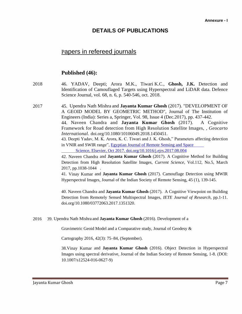
Annexure - I
DETAILS OF PUBLICATIONS
Papers in refereed journals
Published (46):
2018 46. YADAV, Deepti; Arora M.K., Tiwari K.C., Ghosh, J.K. Detection and
Identification of Camouflaged Targets using Hyperspectral and LiDAR data. Defence
Science Journal, vol. 68, n. 6, p. 540-546, oct. 2018.
2017 45. Upendra Nath Mishra and Jayanta Kumar Ghosh (2017). "DEVELOPMENT OF
A GEOID MODEL BY GEOMETRIC METHOD", Journal of The Institution of
Engineers (India): Series a, Springer, Vol. 98, Issue 4 (Dec.2017), pp. 437-442.
44. Naveen Chandra and Jayanta Kumar Ghosh (2017). A Cognitive
Framework for Road detection from High Resolution Satellite Images, , Geocarto
International. doi.org/10.1080/10106049.2018.1450451. 43. Deepti Yadav, M. K. Arora, K. C. Tiwari and J. K. Ghosh,” Parameters affecting detection
in VNIR and SWIR range”, Egyptian Journal of Remote Sensing and Space
Science, Elsevier, Oct 2017. doi.org/10.1016/j.ejrs.2017.08.004
42. Naveen Chandra and Jayanta Kumar Ghosh (2017). A Cognitive Method for Building
Detection from High Resolution Satellite Images, Current Science, Vol.112, No.5, March
2017, pp.1038-1044 .
41. Vinay Kumar and Jayanta Kumar Ghosh (2017). Camouflage Detection using MWIR
Hyperspectral Images, Journal of the Indian Society of Remote Sensing, 45 (1), 139-145.
40. Naveen Chandra and Jayanta Kumar Ghosh (2017). A Cognitive Viewpoint on Building
Detection from Remotely Sensed Multispectral Images, IETE Journal of Research, pp.1-11.
doi.org/10.1080/03772063.2017.1351320.
2016 39. Upendra Nath Mishra and Jayanta Kumar Ghosh (2016). Development of a
Gravimetric Geoid Model and a Comparative study, Journal of Geodesy &
Cartography 2016, 42(3): 75–84, (September).
38.Vinay Kumar and Jayanta Kumar Ghosh (2016). Object Detection in Hyperspectral
Images using spectral derivative, Journal of the Indian Society of Remote Sensing, 1-8. (DOI:
10.1007/s12524-016-0627-9)
Jayanta Kumar Ghosh Page 8
37. Ghosh. J.K. and U. Mishra (2016). Determination Of Geoid Undulation By
Astro-Geodetic Method, ASCE Journal of Surveying Engineering, Volume 142, Issue 3
(August 2016).
2015 36. N.G. Ganpatrao and J. K. Ghosh (2015). Indian Topographical Map Symbols
Understanding System, IET Computer Vision, The Institution of Engineering and
Technology, Vol.9, Issue 2, pp. 300–308 (April).
35. Ghosh. J.K. and S. Pathak (2015). A study on variation in Position of an Indian
Station due to Solid Earth Tides, Journal of Earth System Science, 124, No. 3, pp. 603–612
(April).
34. Ghosh. J.K., D.Bhattacharya, P.Boccardo and N.K.Samadhiya. Automated Geo-Spatial
Hazard Warning System GEOWARNS: An Italian Case Study, ASCE Journal of Computing
in Civil Engineering, 2015, 29(5),04014065 [COPY ENCLOSED]
2014 33. Bhattacharya, Devanjan, J. K. Ghosh, J. Komarkova, S. Banerjee and H.
Kutoglu. Distributed GIS for Automated Natural Hazard Zonation Mapping
Internet SMS Warning towards Sustainable Society, Cogent Engineering,1, 961346.
32. D. Singh, D., J.K. Ghosh, D. Kashyap. Precipitable water vapor estimation in
India from GPS-derived Zenith delays using radiosonde data, Meteorology and
Atmospheric Physics, 123:209–220.
31. D. Singh, D., J.K. Ghosh, D. Kashyap. Weighted mean temperature model
for extra tropical region of India. Journal of Atmospheric and Solar- Terrestrial
Physics 107, 48–53.
30. Mukherjee K, A. Bhattacharya, J.K.Ghosh and M.K.Arora. Comparative
performance of fractal based and conventional methods for dimensionality
reduction of hyperspectral data, Optics and Lasers in Engineering, Vol 55, pp
267-274 (April). [COPY ENCLOSED]
29. N.G. Ganpatrao and J. K. Ghosh. Information extraction from topographic map using
colour and shape analysis, Journal of the Indian Academy of Sciences, SADHANA,
October 2014, Volume 39, Issue 5, pp 1095-1117
2013 28. Bhattacharya,D., J.K. Ghosh, P. Boccardo and J. Komarkova. Automated
Geo-Spatial System for Generalized Assessment of Socio-Economic Vulnerability due
to Landslide in a Region, European Journal of Remote Sensing, Volume: 46 Pages: 379 -
399
27. Sharma, N and J. K. Ghosh. Sevcik’s Fractal Based Dimensionality Reduction of Hyper-
Spectral Remote Sensing Data, International Journal of Computer Science and Technology,
Vol.4, Issue 2, April-June, pp 52-55.
26. Kriti Mukherjee, Jayanta K Ghosh and Ramesh C. Mittal (2013). Variogram Fractal
Dimension Based Features for Hyperspectral Data Dimensionality Reduction,
Photonirvachak, Journal of Indian Soc Remote Sens, Vol. 41 No.2 (June), 249-258.
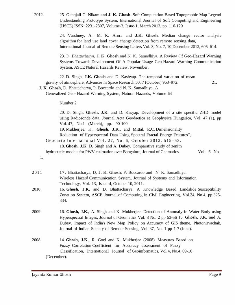
Jayanta Kumar Ghosh Page 9
2012 25. Gitanjali G. Nikam and J. K. Ghosh. Soft Computation Based Topographic Map Legend
Understanding Prototype System, International Journal of Soft Computing and Engineering
(IJSCE) ISSN: 2231-2307, Volume-3, Issue-1, March 2013, pp. 116-120
24. Varshney, A., M. K. Arora and J.K. Ghosh. Median change vector analysis
algorithm for land use land cover change detection from remote sensing data,
International Journal of Remote Sensing Letters Vol. 3, No. 7, 10 December 2012, 605–614.
23. D. Bhattacharya, J. K. Ghosh and N. K. Samadhiya. A Review Of Geo-Hazard Warning
Systems Towards Development Of A Popular Usage Geo-Hazard Warning Communication
System, ASCE Natural Hazards Review, November.
22. D. Singh, J.K. Ghosh and D. Kashyap. The temporal variation of mean
gravity of atmosphere, Advances in Space Research 50, 7 (October) 963–972. 21.
J. K. Ghosh, D. Bhattacharya, P. Boccardo and N. K. Samadhiya. A
Generalized Geo- Hazard Warning System, Natural Hazards, Volume 64
Number 2
20. D. Singh, Ghosh, J.K. and D. Kasyap. Development of a site specific ZHD model
using Radiosonde data, Journal Acta Geodaetica et Geophysica Hungarica, Vol. 47 (1), pp
Vol. 47, No.1 (March), pp. 90-100
19. Mukherjee, K., Ghosh, J.K., and Mittal, R.C. Dimensionality
Reduction of Hyperspectral Data Using Spectral Fractal Energy Features”,
Geoca r to In t e rna t i ona l Vo l . 27 , No . 6 , Oc tobe r 2012 , 515 –53 .
18. Ghosh, J.K, D. Singh and A. Dubey. Comparative study of zenith
hydrostatic models for PWV estimation over Bangalore, Journal of Geomatics Vol. 6 No.
1.
2011 17 . Bhattacharya, D, J. K. Ghosh, P. Boccardo and N. K. Samadhiya.
Wireless Hazard Communication System, Journal of Systems and Information
Technology, Vol. 13, Issue 4, October 10, 2011.
2010 16. Ghosh, J.K. and D. Bhattacharya. A Knowledge Based Landslide Susceptibility
Zonation System, ASCE Journal of Computing in Civil Engineering, Vol.24, No.4, pp.325-
334.
2009 16. Ghosh, J.K., A. Singh and K. Mukherjee. Detection of Anomaly in Water Body using
Hyperspectral Images, Journal of Geomatics Vol. 3 No. 2 pp 53-56 15. Ghosh, J.K. and A.
Dubey. Impact of India's New Map Policy on Accuracy of GIS theme, Photonirvachak,
Journal of Indian Society of Remote Sensing, Vol. 37, No. 1 pp 1-7 (June).
2008 14. Ghosh, J.K., R. Goel and K. Mukherjee (2008). Measures Based on
Fuzzy Correlation Coefficient for Accuracy assessment of Fuzzy
Classification, International Journal of Geoinformatics, Vol.4, No.4, 09-16
(December).

Jayanta Kumar Ghosh Page 10
13. Devanjan Bhattacharya and Jayanta Kumar Ghosh. An Evaluation of
Knowledge Representation Schemes as a Pre-requisite towards development of a
Knowledge Based System. ASCE Journal of Computing in Civil Engineering,
Vol.22, No.6 pp 348-359 ( November/December).
12. J.K. Ghosh and Singh, A. Fractal Compression Of Satellite Images,
Photonirvachak, Journal of the Indian Society of Remote Sensing, Vol. 36, No.
4 pp 299-311 (December) (Won ISRS best paper award 2008).
11. J.K. Ghosh and A. Singh. Fractal Based Dimensionality Reduction of
Hyper- spectral Images, Photonirvachak, Journal of Indian Society of Remote
Sensing, Dehradun, Vol. 36, No.3 pp 235-241 (September)
10. Ghosh, J.K. and A. Dubey. Sensitivity Analysis of GPS Estimated PWV.
Journal of Geomatics Vol.2, No.1 pp 37-42, (April)
9. J.K. Ghosh, A. Singh, and R.C.Mittal. Fractal Feature for Classification of
Hyper- spectral Images of Moffit Field, USA, Current Science, Vol. 94, No. 3, pp
356-358 (February).
8. Ghosh, J.K and A. Dubey. India‟ s New Map Policy – Utility of Civil User,
Journal of Current Science, Vol. 94, No. 3, pp 332-337 (February).
2006 7. Ghosh, J.K, O. Sharma and A. Goyal. GPS Based Control Points for
Mapping, Coordinate, A Journal on Navigation, October 2006, pp 24-27.
2005 6. Ghosh, J. K., K. Kishore, M. Juhuri and D. Sodani. Measurement of
deflection of a bridge, Coordinate, A Journal on Navigation, August 2005,
pp 23- 24.
2004 5. Ghosh, J.K. Automated Interpretation of Sub-pixel Vegetation from IRS
LISS-II Images, International Journal of Remote Sensing, Volume 25, No. 6,
1207-1222 (June). [COPY ENCLOSED]
2002 4. Ghosh, J.K., Godbole, P.N., and Ghosh, S.K. Automated Interpretation of
Sub-pixel Water Cover from Satellite Images, Photonirvachak, the Journal of
the Indian Society for Remote Sensing, Vol. 30, No.1 & 2 pp 53-59.
3. Ghosh, J.K. Global Positioning System and its Application. Indian
Journal of Continuing Engineering Education, January 2002 (pp 42-48).
2001 2. Ghosh, J.K. Automated Mapping of Vegetation from Satellite data,
Geoinformation Science Journal, Vol.1, No. 2, 61-65 (April).
1984 1. Ghosh, J.K. Land Treatment as a Waste Water Management Alternative,
Journal of the Institution of Engineers (India), Students’ Journal, Vol. 64, Pt.S 3, pp
84-85.

Jayanta Kumar Ghosh Page 11
Accepted (3):
2018 49. Deepti Yadav, M. K. Arora, K. C. Tiwari and J. K. Ghosh,” Identification of most
useful spectral ranges in improvement of target detection using hyperspectral data”,
Egyptian Journal of Remote Sensing and Space Science, Elsevier.(Accepted). 48. Jayanta Kumar Ghosh, Vinay Kumar, Ajay Kumar , Sudipta Sarkar and Ajay
Kumar Patel. pH Analysis of water using MWIR Hyperspectral Images, Current Science
(Accepted)
47. Vinay Kumar, Jayanta Kumar Ghosh, Dharmendra Singh and Ajay Kumar
Patel. Detection and mapping of a gas in a Hyperspectral Image, Remote
Sensing Letters (Accepted)
Papers in conference proceedings
Fully Peer-Reviewed Conference Papers
2018 59. Ashu Sharma and Jayanta Kumar Ghosh, (2018), Dominance of perceptual
grouping over functional category: an eye tracking study of high-resolution
satellite images,”SPIE-2018, Berlin, Germany
2017 58. Ashu Sharma, Jayanta Kumar Ghosh, (2017), A Bottom-Up Saliency-Based
Segmentation for High-Resolution Satellite Images, CVIP 2017, IIT-Roorkee Gr
Noida, Pages 169-180
2016 57. Naveen Chandra, Jayanta Kumar Ghosh and Ashu Sharma, A Cognitive
Based Approach for Building Detection from High Resolution Satellite Images,
IEEE international conference on computing communication and automation,
pp.1-5, 2016”.
56. Deepti Yadav, M. K. Arora, K. C. Tiwari, J. K. Ghosh, “Fusion of HSI and
LiDAR data for improving detection of man-made targets, ” International
workshop on Remote Sensing Image Analysis at IIT Bombay on April 16-18, 2016
55.Deepti Yadav, M. K. Arora, K. C. Tiwari, J. K. Ghosh, "Performing target specific band
reduction using artificial neural networks and assessment of its efficacy using various
target detection algorithms,” Proc. SPIE 9845,Optical Pattern Recognition XXVII ,
984507 SPIE Defence and Security, 17-21 April 2016, Baltimore, USA
54.Deepti Yadav, M. K. Arora, K. C. Tiwari, J. K. Ghosh, "An Assessment of
Effects of Various Parameters on Target Detection Using Hyperspectral Data,” Proc. SPIE
9880, Multispectral, Hyperspectral, and Ultraspectral Remote Sensing Technology,

Jayanta Kumar Ghosh Page 12
Techniques and Applications VI, 988023, SPIE Asia–Pacific Remote Sensing, 4-7
April 2016, New Delhi, India.
53. Naveen Chandra, Jayanta Kumar Ghosh and Ashu Sharma, A Cognitive Method for
Object Detection from Aerial Image, IEEE international conference on advances in computing
communication and automation, pp.327-330, 2016.
52. Naveen Chandra, Jayanta Kumar Ghosh and Ashu Sharma, A Cognitive Perspective on
Road Network Extraction from High Resolution Satellite Images, IEEE international
conference on next generation computing technologies, pp.772-776, 2016
2015 51. Naveen Chandra, Jayanta Kumar Ghosh and Ashu Sharma, A Cognitive Analysis for
Building Detection from High Resolution Satellite Images, International Conference on
Cognition Brain and Computation, 2015
2014 50. Sharma Ashu, Ghosh J.K., "Saliency Based Segmentation of Satellite
Images", Photometric Image Analysis + High Resolution Earth Imaging for Geospatial
Information, Munich, Germany (Accepted).
49. Deepti Yadav, M. K. Arora, K. C. Tiwari, J. K. Ghosh, “, "Spectral Discrimination using
Neural Network for Target Detection” National conference on Recent Advances in Computer
Science and Engineering, 8-9 Nov, 2014, (IEEE Explore).
2013 48. Mishra, U and J. K. Ghosh (2013). A Study of Determination of GEOID
Undulation by Astrogeodetic Method, ION GNSS+ 2013, September 16-20, 2013,
Nashville, Tennessee USA.
2012 47. Gitanjali G. Nikam and J. K. Ghosh (2012). Indian Topographic Map Symbols
Understanding System, Proceedings of the 2013 IEEE Second International Conference on
Image Information Processing (ICIIP-2013), pp. 33-38.
46. Mukherjee K, J.K. Ghosh and R.C. Mittal. Variogram fractal dimension
based features fo hyperspectral data Dimensionality reduction, GEOMATRIX-
12, An international conference on Geospatial Technologies & Applications, February 26-29,
Mumbai [AWARDED Best paper award].
45. Mathew, A.P and J. K. Ghosh. A comparative study of nonlinear dimensionality
reduction algorithms for hyperspectral data, GEOMATRIX-12, An international conference
on Geospatial Technologies & Applications, February 26-29, Mumbai.
44. Nikam G. G. and J. K. Ghosh. A Topographic Map Legend Understanding Prototype
System, GEOMATRIX-12, An international conference on Geospatial Technologies
& Applications, February 26-29, Mumbai.
Jayanta Kumar Ghosh Page 13
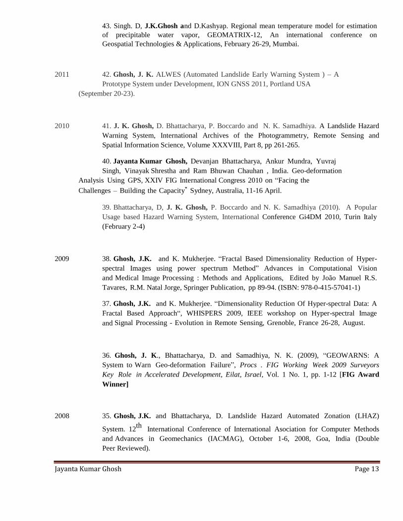
43. Singh. D, J.K.Ghosh and D.Kashyap. Regional mean temperature model for estimation
of precipitable water vapor, GEOMATRIX-12, An international conference on
Geospatial Technologies & Applications, February 26-29, Mumbai.
2011 42. Ghosh, J. K. ALWES (Automated Landslide Early Warning System ) – A
Prototype System under Development, ION GNSS 2011, Portland USA
(September 20-23).
2010 41. J. K. Ghosh, D. Bhattacharya, P. Boccardo and N. K. Samadhiya. A Landslide Hazard
Warning System, International Archives of the Photogrammetry, Remote Sensing and
Spatial Information Science, Volume XXXVIII, Part 8, pp 261-265.
40. Jayanta Kumar Ghosh, Devanjan Bhattacharya, Ankur Mundra, Yuvraj
Singh, Vinayak Shrestha and Ram Bhuwan Chauhan , India. Geo-deformation
Analysis Using GPS, XXIV FIG International Congress 2010 on “Facing the
Challenges – Building the Capacity‟ Sydney, Australia, 11-16 April.
39. Bhattacharya, D, J. K. Ghosh, P. Boccardo and N. K. Samadhiya (2010). A Popular
Usage based Hazard Warning System, International Conference Gi4DM 2010, Turin Italy
(February 2-4)
2009 38. Ghosh, J.K. and K. Mukherjee. “Fractal Based Dimensionality Reduction of Hyper-
spectral Images using power spectrum Method” Advances in Computational Vision
and Medical Image Processing : Methods and Applications, Edited by João Manuel R.S.
Tavares, R.M. Natal Jorge, Springer Publication, pp 89-94. (ISBN: 978-0-415-57041-1)
37. Ghosh, J.K. and K. Mukherjee. “Dimensionality Reduction Of Hyper-spectral Data: A
Fractal Based Approach“, WHISPERS 2009, IEEE workshop on Hyper-spectral Image
and Signal Processing - Evolution in Remote Sensing, Grenoble, France 26-28, August.
36. Ghosh, J. K., Bhattacharya, D. and Samadhiya, N. K. (2009), “GEOWARNS: A
System to Warn Geo-deformation Failure”, Procs . FIG Working Week 2009 Surveyors
Key Role in Accelerated Development, Eilat, Israel, Vol. 1 No. 1, pp. 1-12 [FIG Award
Winner]
2008 35. Ghosh, J.K. and Bhattacharya, D. Landslide Hazard Automated Zonation (LHAZ)
System. 12th
International Conference of International Asociation for Computer Methods
and Advances in Geomechanics (IACMAG), October 1-6, 2008, Goa, India (Double
Peer Reviewed).

Jayanta Kumar Ghosh Page 14
2006 34. Dubey. A and J.K. Ghosh, (2006). "India's New Map Policy - Utility of `Civil User"
ISPRS TC-IV International Symposium on “Geospatial Data bases for sustainable
Development” Goa Abstracts pp6.
2005 33. Singh. A, J.K. Ghosh and R.C.Mittal. Fractal Compression Of IRS LISS-II
Images, 25th
ISRS Annual Convention and National Symposium, “Emergence of
Geoinformatics for Development : Trends & Opportnities”, December 6-9,Ranchi India,,
Compendium of abstract pp 214.
32. Ghosh, J.K. and Sahil Suri. A Knowledge Based System for Assessment of Landslide
Hazard, Proceedings of Indian Geotechnical Conference: IGC-2005, December 17-
19, Ahmedabad, pp. 393-396.
2004 31. Lakkad, J and J.K.Ghosh. Fractal feature of land use class of satellite
images. Proceedings of 46 th
International Symposium Elmar 2004. June 16-18, Zadar,
Croatia pp 561-566.
2000 30. Ghosh, J.K., Godbole, P.N., and Ghosh, S.K. Mapping of Tea Gardens from satellite
Images- A Fuzzy Knowledge-Based Image Interpretation System. International Archives
for Photogrammetry & Remote Sensing (Part-B).
1996 29. Ghosh, J.K. Computer Understanding of Sub-pixel Land Cover, in International
Archives of Photogrammetry & Remote Sensing. Vol. XXX.
1992 28. Ghosh, J.K., Lamar, H., and Roel, N. Forest Cover and Land Use Mapping of a region
of Barak Valley of Assam, India using IRS LISS II imagery, in International Archives of
Photogrammetry & Remote sensing. Vol. XXIX.
1991 27. Ghosh, J.K. and Rampal, K.K. Mapping of Mineralized Zone in Jharia/Raniganj Coal
Fields using Remote Sensing Imagery at Congress VIII of International Society of
Mine Surveying held at Lexington Kentucky, USA.
Other Conference Papers

Jayanta Kumar Ghosh Page 15
2014 26. Sharma Ashu, Chandra Naveen, Ghosh J.K., "Salient Region Extraction of Satellite
Image", Cognitive Computing & Information Processing, JSS Academy of Technical
Education Noida (Communicated).
2011 25. Gitanjali G. Nikam and J. K. Ghosh (2011). A Map Legend Understanding
System, Proceedings of the International Conference on Soft Computing for Problem
Solving (SocProS 2011), IIT Roorkee, India, December 20-22, 2011, Vol. 131, No. 2,
pp. 41-47. Advances in Intelligent and Soft Computing Volume 131, 2012, pp 53-62,
24. Dinesh Singh and Jayanta Kumar Ghosh. Effect of Precipitable
water Vapor in Microwave Propagation, 7th international Conference on
Microwaves, Antenna, Propagation and Remote Sensing (ICMARS – 2011),
International Center for Radio Science (ICRS), Jodhpur, India, December
2011, Paper -147 (S7-04).
2010 23. 'Varshney, A., Arora, M. K. and Ghosh, J.K. " A Modified Change Vector Analysis
Algorithm for Land Use Land Cover Change Detection from Remote Sensing Data"
Conference Proceedings on remote sensing and GIS for environmental management (RSGIS-
EM2010), 10 Aug., , Jamia Millia Islamia Delhi,India, pp.215-226.
2009 22. Ghosh, J.K. and D. Bhattacharya. “Landslide hazard warning
system (LANDWARNS)”, India Disaster Management Congress, New Delhi, November 4-6.
21. J.K. Ghosh and Bhattacharya. D . A Knowledge Based System for Assessment of
Impact of Landslide on Population of a region in Uttarakhand” at National Conference on
“ Geomatics and impact of climate change with specific reference to Mountain Eco-
system” February 5, Dehradun.
2008 20. Verma, S., J.K.Ghosh and R. Yadav. Development of Deformation Monitoring System
based on GNSS sensor, Proceedings of symposium of Location India 2008, February 7-
8, Noida.
19. Ghosh, J.K. An Automated System for Zonation of Landslide in Tehri-Garhwal
District, Uttarakhand (India), Proceedings of Conference on LANDSLIDE
MANAGEMENT, present scenario and future directions, Roorkee, February 10-12.
Jayanta Kumar Ghosh Page 16
18. Verma, S., J.K.Ghosh and R. Yadav. Development of a Prototype for Monitoring of
Deformation, Proceedings of Conference on Challenges and Applications of
Mathematical Modelling Techniques in Building Science and Technology (CAM2tBST),
Roorkee, February 7-8.
17. Ghosh, J.K., Johri, M., Kishore, K., and Sodani, D. “Bridge Deflection Measurement
Using Space Technology”, Proc. of the International Conference on Civil Engineering in
the New Millennium: Opportunities and Challenges (CENeM-2007), 150-year
anniversary conference at Bengal Engineering and Science University, Shibpur, India, Vol.
II, pp. 1137-1141.
16. Bhattacharya, D., and Ghosh, J.K., (2008), “Landslide Understanding System”, Proc. of
the International Conference on Civil Engineering in the New Millennium: Opportunities
and Challenges" (CENeM-2007), 150- year anniversary conference at Bengal
Engineering and Science University, Shibpur, India, Vol. III, pp. 1669-1672.
2007 15. Ghosh, J.K. and A. Singh. Land-Cover Anomaly Detection Using
Hyperspectral Images. Proceedings of the National Conference on High Resolution
Remote Sensing & Thematic Application, December 18-20, 2007 Kolkata Pp 101.
2006 14. Ghosh, J.K., S. Kumar and A. Dubey (2006). Precursor Of Earthquake Based On
Geodetic Computation, 13th
Symposium on Earthquake Engineering (13 SEE), December 18-
20, Roorkee.
13. Ghosh, J.K., S. Vaibhav, K.Kishore, M. Juhuri and D. Sodani. Measurement of
Deflection of Bridges Using GPS. Proceedings of National Symposium on Bridge
Engineering March 24-25, Roorkee pp 605-611.
12. Singh. A, J.K. Ghosh and R.C.Mittal. Compression Ratio as Complexity Measure of
Remote Sensing Images, Geomatics -2006, “Geomatics for Infrastructural
Development”, January 4-6, Chennai India.
11. Vaibhav, S and J.K. Ghosh. Geomatics Based Measurement of Bridge Deflection.
Geomatics -2006, “Geomatics for Infrastructural Development”, January 4-6, Chennai India
pp.
2005 10. Ghosh, J.K. and K. Mukherjee. A Comparative Study Of Accuracy Assessment
Methods For Fuzzy Classification Of Satellite Images, Proceedings of Map India 2005, 7 –
9 February, New Delhi.
Jayanta Kumar Ghosh Page 17
2004 9. Mukherjee, K and J.K. Ghosh. GPS Based Fault Locator in Power Grid, Abstract 24th
ISRS Annual Convention and National Symposium, “Converging Space Technologies
for National development”, November 3-5, Jaipur India pp 227-229.
8. Lakkad, J and J.K.Ghosh. Fractal feature for land use class of satellite images, Abstract
24th
ISRS Annual Convention and National Symposium, “Converging Space Technologies
for National development”, November 3-5, Jaipur India pp 119.
7. Bhattachryaa. A and J.K. Ghosh. GPS Based Determination of Wind Force, Abstract
24th
ISRS Annual Convention and National Symposium, “Converging Space Technologies
for National development”, November 3-5, Jaipur India pp 235-237.
6. Ghosh, S and J.K. Ghosh. GPS Based Estimation of Real Time Agricultural Water
Demand , Abstract 24th
ISRS Annual Convention and National Symposium, “Converging
Space Technologies for National development”, November 3-5, Jaipur India pp 6-8. (Won
Award in ISRS 2004)
2001 5. Ghosh, J.K., Godbole, P.N., and Ghosh, S.K. Automated Mapping of Tea Gardens from
satellite Images, All India Seminar on Infrastructural Development in Uttaranchal-
Problems & Prospects (IN-D-U-2001), Roorkee October.
4. Ghosh, J.K. and Ch. V.A. Rao, GPS Control Point Positioning. Asian GPS Conference
held at New Delhi (October 29-30).
1999 3. Ghosh, J.K. Interpretation System for Sub-pixel Vegetation Cover, in Geoinformatics:
Beyond 2000 an International Conference on Geoinformatics for Natural
Resources Assessment, Monitoring and management held at Dehradun, India during March 9-
11.
1997 2. Ghosh, J.K. Sub-pixel Water Cover Interpretation System, National Conference on
Remote Sensing for Natural Resources with special emphasis on infrastructure
development held at Hyderabad, November 26-28.
1995 1. Ghosh, J.K., Godbole, P.N., and Ghosh, S.K. VEXIN Vegetation EXpert Interpretation
System Proceeding of International Workshop on International Mapping from Space held
at Madras, India.
Books
Jayanta Kumar Ghosh Page 18
2016 A Text Book On GPS Surveying (First Edition), CRC Press, US.
2010 Elementary Engineering Surveying, Studium Press, New Delhi
Monographs
2012 1. “Development of a Landslide Hazard Assessment System” LAP LAMBERT Academic
Publishing GmbH & Co. KG, Germany, published May 2012.
2. “Development of a Geo-hazard Warning Communication System” LAP LAMBERT
Academic Publishing GmbH & Co. KG, Germany, published Aug 2012.
Chapter of books
2012 “Fuzzy Knowledge Based GIS for Zonation of Landslide Susceptibility” by
J.K. Ghosh, D. Bhattacharya and S.K. Sharma Chapter 2 in “Applications
Of Chaos and Nonlinear Dynamics in Science and Engineering - Vol. 2,
Understanding Complex Systems, DOI 10.1007/978-3-642-29329-0_2, #
Springer-Verlag Berlin Heidelberg 2012 Editors - S. Banerjee, M. Mitra, L.
Rondoni, ( http://www.springerlink.com/content/88x321100k07244h/)
2001 “Fuzzy Logic: Basic Concepts” in Geographical Information Science“ published
by Geoinformatics Division Indian Institute of Remote Sensing Dehradun.
Editor
Proceedings of “ Geomatics in Civil Engineeing” (Springer) [Ongoing]
Patent Filed
Title: Navigation System for an Autonomous Terrestrial Vehicle [Ref. No. 201711043997];
Application No.TEMP/E-1/44616/2017-DEL.
*****
Jayanta Kumar Ghosh Page 19
Annexure - II
Miscellaneous
Invited Lectures delivered
2018 IIEST Sibpur (Februay 2 & 3).
2016 National Workshop on Recent Advances in Civil Engineering (NWRACE ) at
Bankura Unnayani Institute of Engineering (October 28), 2016.
2014 "A UAV based Autonomous System for surveillance and proclamation of warning
during disaster' in the SSTDM (Small satellite and Technological Development for
Disaster management) at IISc Bangalore (April 02), India.
2014 "GPS for GIS" in the STTP on “GIS applications in Engineering” at NIT Silchar
(January 17).
2012 "Geomatics for Small Hydro-power Projects" AHEC IITR, June 18 India.
2007 "E-learning in the Perspective of Surveying" at University of Applied Sciences,
Karlsruhe, June 14 Germany.
2006 "Approach of IITR in VLBI program in India” at BARC, Mumbai, November 03.
2006 "GPS Surveying" at Birla Institute of Technology, Mesra. (September 3-5).
2004 "GPS Data Collection Analysis" in QIP STC on RS and GIS applications with
special emphasis to Infrastructure Planning (June 8).
2003 "GPS for forest Surveying" Forest Survey of India, Dehradun.
Academic Foreign Visits
2011 USA International Conference ION GNSS 2011, Portland Oregon & presented a
paper ALWES (Automated Landslide Early Warning System ) – A Prototype
System under Development. 2010 JAPAN, International Conference of ISPRS Technical Commission VIII
Symposium at Kyoto, Japan. 2009 PORTUGAL, Instituto Superior de Estatística e Gestão de Informação (ISEGI),
Universidade Nova de Lisboa, Portugal (ERASMUS MUNDUS EU fellow). 2009 ISRAEL, International Conference “Surveyors Key Role in Accelerated Development “FIG Working Week 2009 in Eilat, Israel. 2008 ITALY, Politecnico de Torino. Bi-lateral cooperation leading to exchange of
Young Indian scholar for joint research project. 2007 GERMANY, University of Applied Sciences, Karlsruhe for Post- doctoral
research work under DAAD.
Membership of Professional Bodies
Indian Society of Remote Sensing (ISRS) (Life Member) L-638
Indian Society of Geomatics (ISG) (Life Member) L-340
Indian National Cartographic Association (INCA) (Life Member) LM-938

Jayanta Kumar Ghosh Page 20
Institution of Engineers (Ind) [IE] (Life Member) LM-111548
Indian Society for Technical Education (ISTE) (Life Member) LM-11258
Indian Society for Continuing Engineering Education (Life Member)
Reviewer of Journals American Society of Civil Engineering Journal of Computing in Civil Engineering, USA
American Society of Civil Engineering Journal of Hazardous, Toxic, and Radioactive
Waste, USA
Institute of Electrical and Electronice Engineers Geo-science Enginering, USA
International Journal of Remote sensing, UK
Advances in Space Research, France Journal of Atmospheric and Solar-Terrestrial Physics, Elsevier
Fractals, Singapore
International Journal of Geoinformatics, Thailand.
Sadhana, Proceeding in Engineering Sciences of Indian Academy of Science.
Photonirvachak, Journal of the Indian Society of remote Sensing, India.