Embed Size (px)
Citation preview
No. IOMay 1994
Jamaican Geographer Newsletter of the Jamaican Geographical Society
ISSN t0 17-4753
FIELD TRIP TO GOD 'S WELL,
FARQUHAR'S BEACH AND M ILK RIVER BATH
OnSaturda y, March 28th, 27 JGS memhers and fr iend s par ticipated in a f ield trip to Farquhar" s Beach, God ' s Well and Milk River Bath, in southern Clarendon , The trip was led byDr Stephen Donovan, ge ology departmen t, UWI.
The first stop was at Gods ' Well, a spe ctacular sink hole in the Mioce ne Newpo rt Formation, north of Round Hill. It was most probably form ed by roof collapse of a major underground cavern . The feature is oval and measure ' b tween 25m to 40m in diameter, has near vertical sides, and the distance to tile water level he low is approximately 25m . God ' s Well is drained to the wes t, where it issues as a spring at tile head of UlC Alligator Hole Riv r. In tile micl- 1980s, it was the si te of tra rcdy and death, involvi ng a group cave divers exp loring the underwater ca ves which connect into God 's Well.
The next stop was unscheduled; a brief deto ur to tile NRCA' s Canoe valley vis itor centre. Although the y were not seen by we group, three manatees (s a cows) have been coral lcd in the river since the 1980s, in an effo rt to encourage them to breed . The ex peri ment fa i le d an d experts ha ve recentl y determined tha t all three an ima ls are females. Man y of the JGS members present expressed the iew Ulat the time has come to release them, to rej oin the tiny population of manatees which still exists in Jamaica,
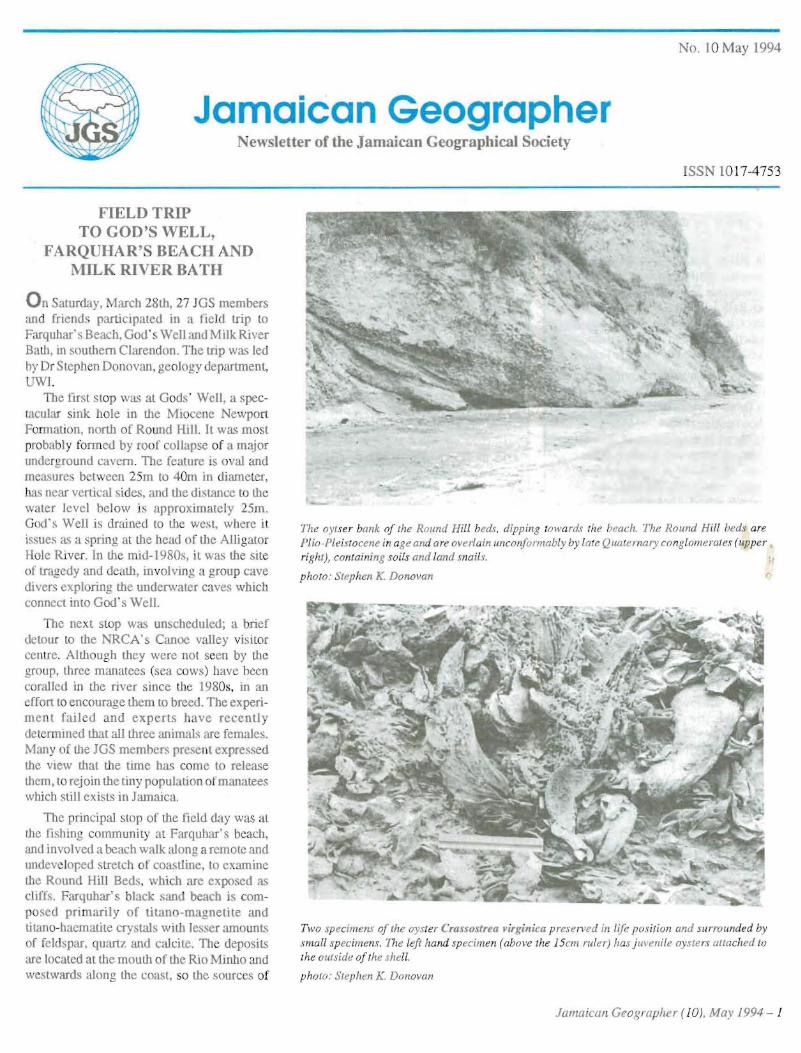
The principal stop of the field day was at the Iishmg comm unity at Farquhar's beach , and involved a beach walk along a remote and undeveloped stretch of coastline, to examine the Round Hill Beds . which are ex posed as cl iffs. Farquhar 's black san d beach is compo sed pri marily of titano-magnetite and titano-haernatite crystals with lesser amounts of fe ldspar , quartz and calcite. Th e deposits are located at the mouth of the Rio Minbo and westwards along the coast, so the sources of
The oytser bank of the Round Hill beds, dipp ing towards the beach. The Round Hill heds are Plio -Pleistocene in age and are overlain unconformably by late Quaternary conglomerates (upper right), containing soils and land mails"
photo: Stephen K. Donovan
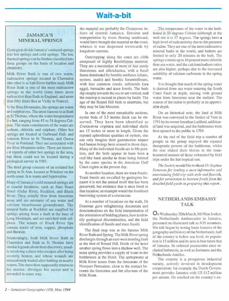
Two specimens of the oyster Crassostrea virgin ica p reserved it ! lij« po siti on and surrounded by small specimens, 171/: left hand specimen (above the 15c/IJ ruler) has j uvenile oysters attached tv the outside of the shell.
photo: Stephen K. Donovan
Jamaican Geographer ( IOJ, May 1994 - 1
Wait-a-bit
JAMAICA'S MINERAL SPRINGS
Geologis ts di vide Jamaica's mineraI springs into hot springs and cold springs. The hal, thermal springs can he furth er classified into three groups on the basis of location and chemistry.
Milk Ri ver Bath is on e of two warm, radioactive springs located in Clarendon (the other is at Sal t River further east). Milk River Bath is one of the mos t radioactive springs in the world (n ine tim es more radioactive than Bath in England, and more than tifty times that a t Vichy in France).
In the Blue Mountains, the springs are wann and sulphurous. Th e most famous i . at Bath \11 St Thomas, where the water temperatures . re hot, ranging from 45 to 54 degrees Ce lcius, The main constituents of the water are odium, chloride and sulphate, Other hot
springs are located at Garbrand Hall , and Johnson Rive r in St Thomas, and Guava Rive r in Portland . They are associated with the Blue Mountain inlier. Th ere are historical reports of other hal springs in the area, but these could not be located during a geological survey in 1981.
TIle third group consists of an isola ted hot spring in St Ann, located at Windsor on the north coast. It is warm and hypersaline.
Many of Jamaica's cold mineral sp rings arc at coastal locations, such as Sans Sa ud Hotel (Och o Rios ), Rockfort, and Black River. They usually now from limestone areas and are mixtures of sea water and ca lcium bicarbonate groundwater. The mineral baths at Rockfort are supplied by . prings arising from a fault at the base of Long Mountain, and are enriched with sul phate . The wa t rs of Black River Spa contain traces of iron , copper, pho sphate and l1uori de.
Interestingl y, hOUI Milk Rive r Bath in Clarendon and Bath in St Thomas have similar legend" about their discovery , usually involving a Slave who escapes after being severely beaten, and whose wound are miraculously healed after bathing in nearby waters.The slave then supposedly returns to hi master, d ivulges his secret and is rewarded in some way .
2 - Jamaica n Geogra pher (10) . May 1994
the material are probabl y the Cretaceous inliers o f ce n tr a l Jamaica. Erosi on and transportation by rivers fl owing southward, would have brought the material to the coast, whence it was dispersed westwards by longshore currents.
Outcropping along the coas t are cliffs composed of highly fossiliferous material . They are a succession of more or less sandy limestones and siliciclastics, with a fossil fauna dom inated by benthic mollu scs (clam s, oysters, snails) and benthic foram iniferans. with less common corals . echinoids (sea eggs), barnacles and trace fossils. The beds dip steeply towards the sea or are vertical, and the outcrop is incised in places by faults. The age of the Rou nd Hill beds is uncertain, but they may be late Miocene.
In one of the most remarkable sections, oyster beds of 3.3 metres thick can be observed. T hey have bee n identified as Crassostrea virginica and individual shells are 15 inches or more in length . Given the reputed aphrodisiac qualities of oysters, one can only imagine their gas tronomic impact had human beings been around in those days. Many of the individual fossils are in life pos ition, and the beds app ear to have becn a reef-like bank similar to those being forme d by the same species in the American Gul f Coast region at tile present day.
At another location, there are trace fossil s. Trace fossils are so-called by geologists because it is not the animal itself that has been preserved, but evidence that it once lived in that location; an example would the fossilised burrowing system of a cnn tacean.
At a number of locations on Ule walk, Dr Donovan gave enlighten ing discourses and demonstrations on the field interpretation of the orientation of bedding planes, how to identify geolog ical discon tinuities, and the field identification of fossils and trace fossils
The final sto p was at the famous Milk River Bath and Spring. The Milk River spring discharges through an east- west trending fault at the foot of Round Hill . North of the hotel ano ther spring flows into a shallow well. The mai n spring provides a supply of water to the bath houses at the Hotel. The springwater at M ilk River issues from the limes tone of the Newport Formation, close to the contact between the limestone and the allu vium of the Milk River.
The temp erature of the water in the bathhouse is 33 degrees Cel sius (although at the well site it is 37 degrees. Th e springs have a high level of radioactivity due to the presence of radon. They are one of the most radio active mineral bath s in the world, and bathers are lim ited to only 20 minutes in the bath . The spring s contain up to 16 percen t more chloride than sea water, and the calcium/sodium ratios are also higher, perhaps due to the increased solubility of calcium carbonate in the spring wa ter.
II. is thought that mu ch of the spring water is der ived from sea wat er entering the South Coast Fault a t depth, mi xing with ground wate r from limestone near the surface . The source of the rad on is probably at an apprcc iable depth.
On an historical note, tile land at Milk Rive r was conveyed to the Justice of Vere in 1791 by its ownerJonathan Ludford, additional land was acquired , and the bathrooms were first opened to the pub lic in 1794 .
A t the end of tile field trip a number of people in the group enj oyed the reputed therapeuti c powers or the bathhouse, whilst the rest slaked their th irsts in the timehonoured manner of those exh austed by field trips under the hot tropical sun.
The Society would like to thank Dr Stephen Donovan fo r leading a most informative and entertaining fi eld trip with style and fl ourish. and f or permission to borrow f reely fro m his deta iled fi eld gu ide in preparingthis report.
NETHERLANDS EMBASSY TALK
On Wedn esday 30th March . MrNicoJonker• the Netherlands Ambassador to Jamaica, presented an illustrated talk to lGS members. His talk began by noting basi c features of the geography and history of the Ne therlands: half of the country is below sea level, its populalion is 15 mi llion and its area is four times that of Jamaica . lIS colonial possessions once included Indonesia , as well a" Suriname and the Netherlands Antilles .
The country is a prosperou s indu stri al society, acti vely in volv ed in development cooperation; for exam ple the Dutch Government provides Jarnaica with US $ 12 million per annum. He touch ed on his country 's ex
Wait-a-bit
GEOBEAT
A Newsletter of the Geography Association of Trinidad and Tobago
One of our sister socie ties in the Eastern Caribbean. the Geographical As ociation of Trinidad andTobago is enjoying a revival, and has introduced a 12-page newsletter for its members. Called Geo beat it is edited by Rose-Lee Brown, a teacher at St Stephen's College, Princes Town ncar San Fernando, and graduate of the geography department, UWl. Two issues have appeared to date . The newsletter contains a selection of news items, information on the S ciet " s activities, information and suggestions about field tripsand field work, and a section called 'Play as . ou learn', containing games ami puzzles for geographers,
It is intended that the two societies will share information from their new, letters, from time to time. For example. of interest in th e February issue (#2) of Geobeat was an item on John Niles. a geographer well known ill the region for his book Certificate Geography f or the Caribbean (MacMillan) and his extensive work with CXC geography since 1977. A teacher of some 24 years standi ng, he war appointed as the fi rst Curriculum Officer in geography for Trinidad & Tobago by the Ministry of Education in 1993. The work he has accomplished in his new role was warmly appreciat d in the newsletter, especially through visiting school. in a monitoring and advisory capacity, and in workshops designed to facilitate the introduction of S.B.A. (School Based Assessment) for CXC g ography.
Another item of interest was an interview with Judy Rocke, currently teaching at New Grant Anglican School. Jud y obtained a first class honours degree in geography at UWI in 19 3, the first 'first' in the department in seventeen years. In the interview, Judy talked about her rural background. her life in the south of Trinidad, her early teaching career, and particularly about her experiences and friends in Jamaica.
If you want to make contact wiLh uie Geographical Association of Trinidad & Tobago, in order to obtain their news lett r for yourself or your school, or to send them material about Jamaica, or to arrange penpals for your students, a few contact persons are listed below:
President: Charlene Costell oe, St Augustine's High School,
Vice President: Patricia Ramgoolam, Naparima Girls' High School.
Secretary: Rampeyari Lalla, Pleasantville Senior Comprehensive School,
Public Relations Officer: Michael Gabriel, Holy Faith Convent, Penal,
Editor, Newsletter: Rose-Lee Brown, St Stephen's College. Prince' s Town,
perience with the European Community. and the need for economic adjustment th rough market competi tion, citing the example of tile r lalivc costs of Dutch and Italian tomatoes. The Neth rlands has a vibrant tourist industry with over 700 museums . Tulips, for which the country is world famous, were originally broueht in from Turkey, four hundred years ago.
Water control and land reclamation is very important in a country whew 60 percent of the popula tion live in low-lying areas . Over the centuries. complicated systems of dykes have been construc ted to prev nt encroachment from the sea. The last major flood was in Fe bru ary 19 53 , when 2,0 00 peop le
perished. This major natural disaster led to the formulation and implementation of the Delta project, a complex series of gigantic engineering structures built to ensure that sea flooding on a similar scale would never occur again in the Netherlands.
The audience were then treated to an exce l lent 2 5 -mi nu te film show ing th e construction of the huge Storm Surge barrier on the Eastern Scheldt, the final stage of the Delta Projec t.This mammoth engineering feat has been designed not only to prevent sea flooding but has also incorporated features to protect tne natural environment. The entire Delta project took 30 years to complete.
NIGERIAN EMBASSY TALK
On Wcdn sday, 27tll April, Mr BJ. anna.. the Depu ty High Comm issioner a t the Nigerian Embassy gave an int erestin g talk about his country. He introduced th audience to its geography and its complicated make-up of different ethnic groups.
He focussed on that huge country' s search for a viable administrative structure. Prior to lY 14, the British admin ist ered iger ia through separate North and South Protectoratcs . When the country gain ed its i ndependence in 1960, the unified Federal structure inherited from the British was unworkable, because of UIC dominance of the North,
Since the B iafr an civil war (1967-1970), the country has been seeking a more balanced Federation: 12 states were created hy President Gowan in the aftermath of tJ1C civil war. Th is number was increased to 19 in 1976 and 21 in 1986. A new federal system was introduced in 1990 expanding the number of states 10 30. But the problem is where to stop the process of administrative tragmentation, hecause Nigeria has over 300 ethnic groups in thc country.
In the late 1960s, Nigeria experienced an oil boom. and benefi tted from the high prices for oil after the OPEC crisis or the 197tls. A development programme was embarked upon based on UIC high price of oil at II'at time ( S $40 per harrel). For example, lrcc education was introduced and there were mad)' statefunded development projects , But there was litt le investment in UIC productive sector . Afteroil prices collapsed, the government hall to borrow huge , urns of money, and inc itahly the rMF stepped in. and imposed a harsh programme of structural adjustment.
Othcr points touched on concerned minor boundary problems arisinu from 111e receding shoreline of Lake Chad (and UIC sudden appearanc e of new isl ands in the lak e) , protracted border dispute.' with Cameroon, and the location of the new capi tal. Ahuja, in the middle belt of the country, an area of minority tribes which was badly depopulated during the slave trade.
Jamaican Geographer (10), May 1994 - 3
Campus Geography
CHAIR OF ENVIRONMENTAL MANAG EM ENT
E limbelb Thomas-Hope has been appointed to the Jame s Seivw righllMoss Solomon SnL Chair of Environmental Management. The Chair has been endowed by the Grace Kennedy Foundation and the appointme nt is to UWI' s Centre for Environment and Development, located on M ona Campus.
Professor Thomas -Hope , a Jamaican, was former ly in the geography department at the University of Liverp ool, and has published widely on population mobility and migration. Her most recent book is Explanation in Caribbean Migration (M acmillan , 1992). In the pas t, she was attach ed to ISER, and several of her PhD students ha ve worked in Jamaica. She has brought groups of UK geograph y undergraduates here on field work. We wish he" every success in her new post, look forward to a fruitful co llabor ati on with the geograp hy dep artm ent, and welcome her to the JGS.
IAFIUWI SEMINAR IN TRINIDAD
P ostgraduate Alth ea Joh nson presen ted a paper based on research in progress at the annual IAFIUW I Fell ows seminar , held in Jun this year at the St Augustine Cam pus, UWl. Her work is documenting the pressure on traditional resource management sys tems of five com munities located in the Black River lower morass wetland. The area is sla ted to become a National Park, and is opening up to ecotourism.
M.PHIL FOR PAULETTE MEIKLE
Paulette Meikle has been awarded an M .Phil degree for her thesis entitled 'The changing patterns of root crop production and marketing in Jamaica' .
The research anal ysed the spa tial and temporal pattern s of root crop production in Jamaica over a fifteen year period. The focus was two communities, Sawyers in Trel awny, an area specializing in yellow yam for tile expo rt market, and Cascade in Hanover, which produces for the domestic market.
Detailed field data on cropping systems, agronom ic practices and decision-making, in the realms of crop production and marketing, were compiled and analysed, and the rural development contexts of the two communities were contrasted . The project' s fieldwork was funded by an IAFIUWI Fellowship.
Paulette presented a paper on her research at the 1992 Br itish-Car ibbean Geography Seminar which has been published (see Ibis page).
In addition to tutoring and demon strating, Paulette lectured first year cl imatolog y when the department was short-staffed. Presentl y, she is employed as a research offi cer on the Rio Grande Vall ey Rural Development Proj ect, a project funded jointly by the Dutch and Jamai can Governments. She is working with Dr Wim Ettema, a Dutch geog rapher and rura l de vel opment co ns ulta nt, wh o was formerly editor of the well known journal TESG. Wim is a recent recruit to the lGS.
Recent Journal Articles by Members of Geography Department
Bailey. W. (1994 ) 'Th e effec t uf user fees on the util izatiun uf family planning service s' , West Indian Medical Journal , 43(2), pp 46 -47.
Bailey. W. (199 4) 'S ho w, No-show and sterilization', Wes{ Indian Medical Journal. 43(2) pp 43-45.
Barker. D. (1992) 'The UWI Scholarship examina tion in geography: an analysis of the 1992 results' , Caribbean Geography, 3(4) pp 270-274 .
Harker . D . ( 1993) 'Dualism and dis tasters on a tropical island : cons traints Oll agricultural devel opment in Jamaica '. TESG. 84( 5) . pp 332-340.
Barker, D . ( 1993) 'T he progress of Caribbean Geography. 1983-93 ' , Caribbean Geograp hy, 4(2), pp 76-87 .
Meik le, P. (1992) 'Spatia -temporal trends in roo t cro p prod uction and mark etin g in Jamaica ' , Caribbean Geograph y . 3(4) , pp 223-235.
Mille r. D.J .. Ahmad , R. & A. Mansingh (1993 for I992) ' Effec ts of population pres sure on the phy sical environment of Jamaica. Jamaican Journal ofScience and Technology' , 3(2) pp 1-5.
4 - Jamaican Geogra pher (10), May 1994
FIRST FACULTY OF NATURAL SCIENCES
CONFERENCE
Two papers were presented by members of me geography department a t the first FNS Conference held in May, on 'Mona campus. A nn e L y e w -A ye e a n d W i lm a Ba i le y presented a paper entitled 'An analysis of the pattern of family planning service delivery points in Jamaica ' . The second paper was presented by pos tgraduate s tudent Vileitha Davis-Morrison entitled ' Agriculture, rural develo pment and the environment in the Rio Grande Valley, Portland ' .
PHYSICAL GEOGRAPHY COURSES EXPANDED
F ortner graduates of the department will remember that in final year , geomorphology and cl ima tology were once taught as a single co urse. Recentl y, the physical geography teaching programm e has been expanded to accommodate the growing interest in tile environrnent, and the skills and research experiencc of its presentcomp lemen tof physical geography lecturers. Two courses, Advanced Physical Geography I (Geomorphology) and. from Ibis semes ter, Advanced Physical Geography III (Climatology) have replaced the single course which was previously offered.
QUIZ: MATCHING PAIRS
Match ten of the new countries of the fa nner USSR w ith their capitals
Countries Capitals
1. Armenia A. Baku
2. Azerbaijan B. Kiev
3. Belaru s C. Mensk
4. Estonia D. Riga
5. Georgia E. Sumarkand
6. Kazakhs tan F. Tallinn
7. Latvia G. Tashkent
8. L i thuania H. Thilisi
9. Ukraine I. Vilnius
10. Uzbekistan .f.Yerevan
Classroom Geography
1VIAY PEN SPHERE OF INFLUENCE
SURVEY
P erez Cr oss writes ...T he JGS or ganised a sphere of in fluence survey for secondary schools on Saturda y. Febru ary 5th . It involved some fifty students and seven teachers fro m eight schools (Man ches ter, S t Jago , Holy Ch ildh ood , Im m acu late Conc e p t io n, St Andrew , Exce lsior and Cal abar . The da y' s acti vities were centred on central Jam aica ' s larges t town, May Pen (pop. 47,0(0).
T he e xe rc ise w as aimed at exp osing seco ndary students , especially 5th and 6th fa nners, to fie ld survey meth ods in a way which al lows them t explore and discover inform ation prev ious ly unknown to them. The large number of part icipating student'; made the exercise easi er to complete in the al lotted time. For the question naire surve y. the students fanned out in pairs a long the Ce ntral Business District (CBD) to interview persons engag ed in business ac tiv ities.
S tude n ts were allowed to interview as many peop le a ' possible within the all otted time . TIle main objective was to ascertain how ncar to, or far from , the tow n the respondents travell ed to shop or to se ll.
May Pen is a major market and administra tive cen tre for its pari sh , Cl are ndo n. l t has all the feat ures and service s typical of a subregional centre, such a. a larg e market, loca l go vern ment offi ces, some regional offices of central gove rnme nt, some stannary depar tmcnts , regional social serv ices/insti tutions like Pol ice, Fire, Health, Postal and Edu cation, branches o f major financia l institution s and a wide range of commercial, retaili ng and whole. aling ac tivities.
Some survey findings
Smnpl e respondents fanne d a ratio of mal e 450/, to femal e 55%, Approximately 64% of the sam ple were under 30 years of age. and 73% Iived within a ten-m ile radi us of the town and its immediate environs.
The furthest point from which an y of tile respondents travelled was Mandeville. Mode of travel to May Pen wa. divided eq ually be tween public transport (bus or tax i) and walkin g . Occupa tional sta tus was "quite varied, includin g the following categories: housewife , farmer, market vendo r, tail or, stu dent, mode l. s tore clerk, handy worker,
businessman and unemplo yed. Th e sample incl uded both vendors and shoppers, and they were asked about their main reasons fo r doin g bus iness in May Pen. The main reasons cited were proximity (distance) to home (46% of vendors and 36% o f sh op per s ) , a nd sa les/pr ice. (I 80/, of vendors and 27 % of shoppers), respec tively.
Most respondents gave May Pen a good rating for service functions; 82% gave the town an approval rating of 6 or greater (on a scale whose max imum 10 was 'excellen t') . Th e maj or services used (excl uding the market) were banks. health and postal service followed by educational and entertainme nt facili ties. Items cited most frequently as absent or poor: infrastruc ture improvements (road repairs and renovation of the town 's bu ildings); and job crea tion/enhancement opport unities (ie new factory or train ing centre).
May Pen's CaD and Land Use patterns
May Pen is essentiall y a 'one road town' wi th the majority of its commercial activity concentrated along a com mercial strip from Main Street, where it crosses the train lines , to Manches ter Avenue and to M uirhead Ro ad. These roads, in spit e of junctions, tend to om in to each other. Commercial activ ity along side stree ts tend. to fade after four or five lots, giving way to residenti al landusc . TIle town docs not have a grid patten! road network, like Kingston or Span ish Town, but a linear, rib bon development f rrn.
Th e studen ts were given group assign m ents to map partic ular stretches of the comm ercial strip between the railway tracks at the eastern end of main Street and the Chapc lton road j unction in the west.
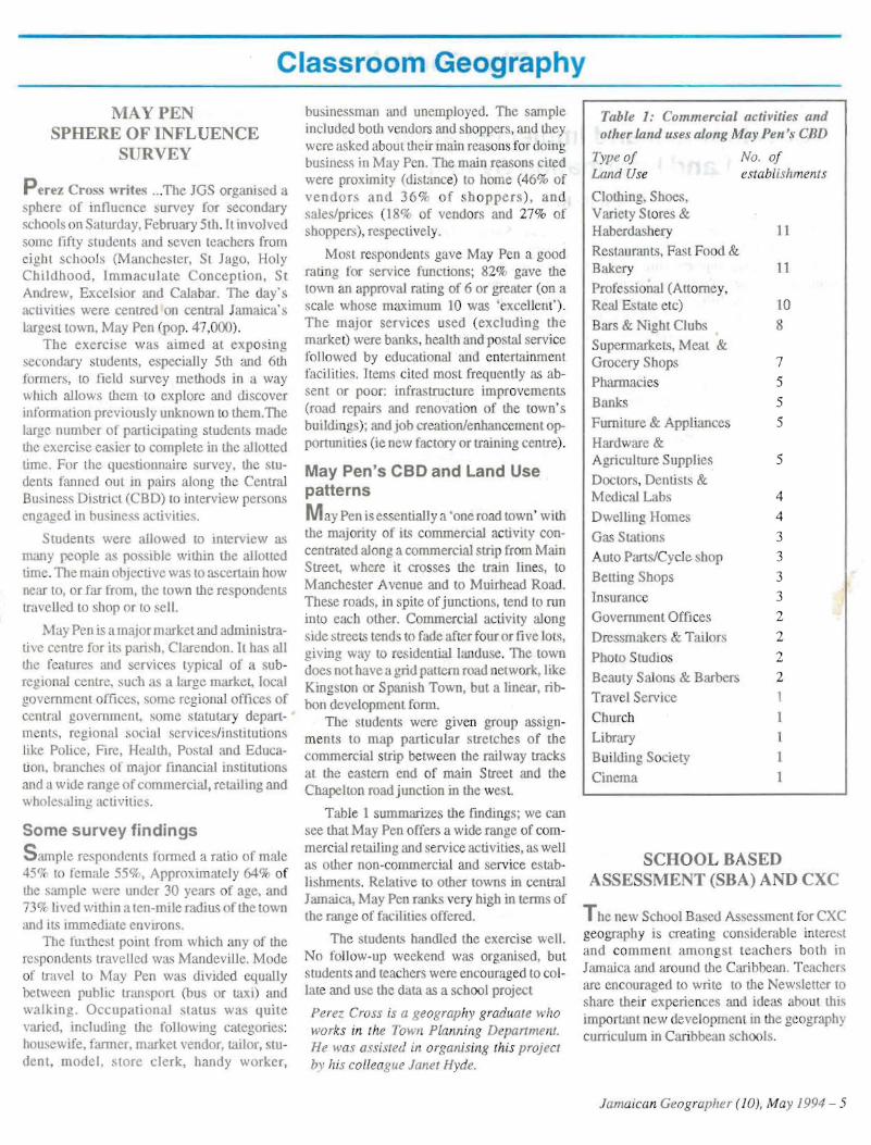
Table 1 summarizes the find ings; we can see that May Pen offers a wide range of commercial retailing and service ac tivities, as well as oth er non-commercia l and service establis hments. Relative t other towns in central Jamaica, May Pen rank s very high in terms of the range of facilities offered.
The students handled the exe rcise we ll. No follow- up weekend was organised , bu t students and teachers were encouraged to collate and use the data as a school projec t
Perez Cross is a geography graduate who works in the Town Planning Depart ment. He was assisted in organising this project hy his colleague Janet Hyde.
Table 1: Commercial acti vities and other land uses along May Pen 's CnD
Type of No. of Land Use establishments
Clothing, Shoes , Variety Stores & Haberdashery 11
Restaurants, Fast Food & Bakery 11
Pro fessional (Attorne y, Real Esta te etc) 10
Bars & Nigbt Clubs 8
Supermarke ts, Meat & Gro cery Shops 7
Phannacies 5
Banks 5
Furniture & Appliances 5
Hardware & Agriculture Supplies 5
Doc tors, Dentists & Medic al Lab s 4
Dwelling Home, 4
Gas Stations 3
Auto Parts/C ycle shop 3
Bett ing Sbop s 3
Insurance 3
Government Offi ces 2
Dressmake rs & Tailors 2
Photo Studios 2
Beau ty Salons & Barbers 2
Travel Serv ice I
Church 1
Library I
Buildi ng Society 1
Cinema 1
SCHOOL BASED ASSESSMENT (SBA) AND CXC
The new Schoo l Based Assessment for CXC geo graphy is creating cons iderable interest and co m m ent amongs t teach ers both in Jam aica and around tile Caribbean . Teachers are encouraged to write to the Newsletter to
share thei r exp rie nces and ideas about this imp ortan t new development in the geography curriculum in Cari bbean sch ools .
Jamaican Geographe r (10 ), May 1994 - 5
The Cockpits
uninterrupted power supply systems (UPS) for regulating voltage tluctuaDevelopment and Implementation of a uons and grace time to enable system shutdown in time of utility outages , Land Information System digital analytic stereo -plotters, for
Cecile Blake c mpilation of digital maps from rec
The Mini ' try of Agriculture with assistance from the Intemational Development Bank (IDB) are currentIy implementing the Land Titling Project, One of tne major objectives of the project is to establish a Land Information System (LIS) across three departments; the Office of Titles, the Lands Administration Division and the Survey Department
A LIS can be d fined as the set of components (hardware, sottv are and people) for the collection, st orage, transformation , analysis, display and dissemination of spatial data which will enabl e the efti cient and effective ma nagement of land resources and improve the plannin g and decision-making process .
Present Situation
T he three departments each function under separate statutes and execute different functions. However, their activities in relation to the processing of land matters are interrelated; that is, the work of one department has an impact and complements the other operations. Presently, they operate manual systems reo' quiring the storage, processing and handling of large quantities of paper records,
The Offi ce of T i tl es processes a pproximatel y 40,000 legal instruments yearly. It has inade quate storage facilities and filing systems. There fore, records are subject to deterioration and damage by insects and pests. The department has an ever-increasing work load which is driven by a pressing demand for new tilles and enquiries about existing ones. Thus, the present system is unable to process expeditiously new titles and to provide answers and docume nts request ed by users .
The Lands Adminisration Divis ion faces similar storage and management problems. The depar tment manages a store of approximately 60,000 land records and 32,500 land settlers' accounts . The filing system is in poor condition and consequently the government is unable to determine the true extent of its land holdings, and settler accounts arc generally in severe arrears.
6 - Jamaican Geographe r (10), May 1994
The Survey De partment manages cadas tral (parcel) and topographic mapping programmes of government. The mapping and surveying functions are done manually, therefore the department can be considered to be technologicaIJy deficient . Because it uses manual operations, the delivery time for standard mapping products is typ ically way above comparabl e private sector times,
Project Objectives
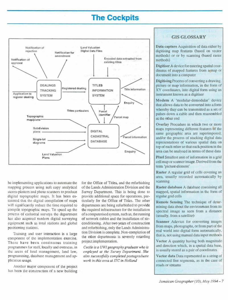
The projeet aims to address some of the major problems outlined in the preceding section by establishing an intelligent, wide-area network of a land information (graphical and textual ) da tabase linking the three departments. The system should provide efficient storage , quick acce ss, prompt delive ry of information to users, enable government to mana ge its land assets, provide current and up-to-date mapping products and, in addition,' deliver new sets of land information products; for example, ortho-photomaps, cadastral maps, and digitial topographic mapping tiles .
Product Activities
The projec t is at the stage of systems implementation, having passed through the stages of system definition and specification, tendering, evaluation, and equipment acquisi tion. Fujitsu-ICL Caribbean was awarded the contrac t for the implementati on of the land information system.
The system is based on a UNIX workstation solution, comprised of 23 workstations and 3 servers . Complementing these arc peripheral equipment such as:
printers (line and laser), for hard copy output,
CD ROM, diskette and tape drives for storage and retrieval of information, plotters (pen and elec trostatic) for hard copy map generation,
digilisers (back-lit and non-back-lit) for me capture of digital map data,
modem, for the transfer/ xchange of digital information,
tified photographs.
Software acquired to operate on the system covers two main areas . The textual portion of the system is heing developed on the lnformix (4GLlRDS) set of database tools and the graphical portion will be done on ARCIINFO (ESRI) geographi cal infonnation system tool box. Additional software to complement the above have also been acquired. For example. Wordperfect and Lotus 123 for UNIX for day-to-day office operations; Hypcrscript for the execution of user queries to ena b le decision su pport; S -P lus for ARC/INFO which will provide tools for sta tistical analysis ; MicroStation for the manipulati on of field data and ARCView for front-end users to execute query and browse operations.
Seven applications being developed are:
(a) For Office of Titles
The Tille Enqu iry System, to store and retrieve titled property information. The Dealings Tracking System, to track all applications and instruments being processed in the office.
(b)For Lands Administration Division
Land Sealers In/ orma tion System, to store and retrieve data on settlers assigned lots under a land settlement scheme. Government Land Management Svstem, to store and retrieve data on ach parcel of land owned hy government. Land Settler Account System, to manage the repayment of settle r accounts .
(c) For Survey Department
Graph ical Property Database, for the storage and retrieval of information on any parcel of land, tilled or untitled. Digital Cadast ral Dat abase, to provide graphical dimen sion to the Title Enquiry System.
To date, five of these applications arc in me process of being developed. Three applications for the Land Administra tion Division ar virtually complete and are currently being reviewed by users. The other two applications for the Office ofTitles are in their primary stage of development.
Under a separate contract, the photograrnmetric section of the Survey Department will
The Cae its
Noti fication of Land Valuation reject ion Digital Data Files
Notificati on for amendment
Notification of appro val
<, / DEALINGS
Registered dealin g TRACKING
Ap pli cation to SYSTEMregister deali ng
Titl es particulars ,
Top ographic
maP/P l an s~
Subdivision pla ns -------
Single-lot diagrams
Land Valuation Plans
bc implementing applications to automate the mapping process us ing soft copy anal ytical , tcreo-plot ters and photo scanners to produ ce digita l topographic maps. It has been es timated that the digital compilation of maps will significantly redu ce the time required to compile topographic maps. To speed up the process of cadastral surveys the department has a lso acqu ired modern digi tal surveyi ng equipment such as total stati ons and global positioning stations,
Training and user in teraction is a large component of the implementa tion exercise , Th e re ha ve be e n c on tinu o us training programmes for SI<1.IT, locally and overseas, in the are as o f lan d management, land law, program ming, da tabase management and application usage,
Another maj or component of the project has been the con struction of a new building
_
Encoded data ex tracted fr om exis ting titles
1 TITLES INFORMATION SYSTEM
........_ - ----,----" ~ \paJel )
ident ifier
1 Parcel map
DIGITAL CADASTRAL DATABASE
for the Office of Titles, and the refurbishing of the Lands Admin istra tion Division and the Survey Department. This is being done to provide additional space for operations, particularly for the Office of Ti tles. The other departments are being refurbished to pro vide the required infrastructure for the installation of a com puterised system, such as , the running of ne twor k cables and the installation of airconditioning. After two years of construction and refurbish ing, only the Lands Administration Division is complete . Non-completion of the other departments is seve rely retarding projec t implemen tation.
Cecile is a UWf geography graduate who is employed at the Survey Department. She also successfully completed postagraduate work in this area at fTC in Holland
GIS GLOSSARY
Data capture Acquisition of data either by digitising map features (based on vec tor methods) or or by scanning (based raster method )
Digitiser A device for entering spatial coordinate,' of mapped features from a map or docum nt into a computer
Digitising Proc ess of converting a drawing, picture or ma p information, in the form of XY coordinates, into digital form using an instrument known as a digitiser
Modem A 'modular-demodular' device that allows data to be converted into a form whereby they can be transmitted as a set of pulses down a cabl e and then reassembled at the other end
Overlay Procedure in whic h two or more maps representing different features of the same geographic area are superimposed; and /or the process of stacking digital data representations of various spat ial data on top of each other so that eac h position in tile area can be analysed in terms of these data
Pixel Smallest unit of in formation in a grid cell map or scanner image. Derived from tile term 'picture element'
Raster A regular grid of cells covering an area, usually recorded aut omatically by scanning
Ra.ster datahase A database containing all mapped, spatial information in the form of regular grid cells
Remote Sensing The technique of determining data about the env ironment from its spectral image as seen from a distance (usually, from a satellite)
Scanner Adevice for converting linag es from maps, photographs, or from part of the real world into digital form automatically, that is, not using manual data input meth ods
Vector A quantity having both magnitude and direction which, in a spatial data base, is usuall y stored as a pair of coordinates
Vector data Data rep resented as a strin g of connected line segments, as in the case of roa ds or streams
Jamaican Geographer (10), May 1994 - 7
Look Behind
CARIBBEAN GEOGRAPHY 1994 VOLUME 5 NUMBER 1
Issues ill Caribbean Sustainable Development, edited by Elizabeth Thomas-Hope and David Barker
Davin Ramphall:Contradic tion: in Cari bbea p Ind ustrializati on as Sustainable Development
Robert B. Potter & Graham M.S. Dann:
Gl o balization, Posunodernity and Susta in abl e Development in th e Commonwealth Caribbean
Robert E. Maguire: Grassroots Development and Community Conflic t in Haiti
Thomas Klak: Maidenfo rming the Caribbean : A review of Jamaica's Industrial Promotion Policy
Mark Wilson: Jam aica 's Bencb Offices: Direct Dial Dependency
Debra Sharkey: Alternative Tourism in Dom inica : Problems and Prospects
Janet Momsen:Gender an d Sustainable small-scale agric ulLure in Barbados
Paul Lorah: Legacies of Environmental Degradation and Political Mismanagement: Antigua's Unsustainable Path
David Watts : Environmental Degradation, th e Water R es ource and Sustainable Development in the Eastern Caribbean
Dennis Con way & Paul Lorah: Environmental Pro tection Po licies in Cari bbean small islands
QUIZ ANSWERS Countries Capitals
l . Georgia Tbilisi
2. Armenia Y erevan
3. Ukraine Kiev
4. Latvia Riga
5. Lithuania V ilnius
6. Azerbaijan Bak u
7. Uzbekistan Samarkand
8. Kazakhstan Tashkent
9. Estonia Tallinn
10. Belarus Mensk
The Nature of Geography
Geography explores the relationship between earth and society . ... the geographer' s highest interest is to study the relationship between earth and people on earth. That way he bu ilds a bridge between natural and social science. When geographers look at spatial relations and interactions they ask the questions: Where iii what? How io; it? Why is it there? Where and how should it be ? The answers to these questions describe and explain the location, situation, and interaction withi n and between places and regions in the worl d. Central concepts of geo graphical studies are Location, Place, Space, Spatial Interaction, Region.
Location: People an d places have different absolute and relative location s on ear th. These are linked by flows of goods, people, and ideas. The knowl dge of the locati on of people and places is tile precondition to understanding regional, national and global interdep endence .
Places: Places have different natural an d human characteristics. Nature produces landform s, soil, climate, waterbodics, vegetation. animal and human life. HUIll<UlS shape dif fer nt cultures, settlements, socio-eco nomic systems and lifesty les according to their beliefs and phi losophies, Knowl edge or the physical characteristics of places and the people's environmental perception is the basis to understand the interrelations betw een peopl e and their places.
Space: People make different use of their environment where they live and work . That way they create differen t cul tural landscapes throu gh di fferen t patterns of ac tivities . On one hand theyare influ enced by theirph ysical setting but on tile other they tran sform their surrounding s into different man -made environments. Understanding these complex interacti ons within space provides an im portant basis for responsible environmental pl anning, management and protection.
Spatial Interaction: Resources and h umans arc unevenly distributed across tile earth. That way they cause a global interdependence . No country is self-sufficient. Transport and comm unication systems link the parts of the world. Changes of loca tions change spatial interrelations and interactions. Insight into spatial in teracti on leads to the und erstand ing of the current co-operation of people by exchang ing goods and information and by migration, but als o to the detection of the current prob lems and to ideas to improve regional. nati onal and international interactions .
Regions: A region is an area that is characterise I by selected criteria. Political cri teri a define, for example, state s and cities; physical criteria, climatic and vegetation zo nes; socioeconomic cri teria, developed and less developed coun tries . Regi ons are ma nageabl e units for studying and deve loping environments. Geographers defi ne regi ons of different scale from local to continental and global dimensions. Th e integrat ed system of regi ons lead s to the concept of planetary ecosystem. The understanding of the structure and processes of these different regions within the global sys tem is the bas is of the reg ional and nati onal identity of people and their international solidarity as well.
Source: Inte rnational Charter on Geographical Educ ation, Commi ssion on Geographical Education, International Geographical Union, Washington, 1992
Editor:
Addre ss:
Typesetting:
Printing:
Jamaican Geographer
ISSN 1017-47 53
Da vid Barker
Department of Geography, TIle University of tile West Indi es, Mona Campus. Kingston 7, phone 927 -2129
David Barker & Donny Miller
University Printery. The University of the We st Indies , Mona Campus, Kingston 7.
8 - Jamaican Geographer (10), May 1994