Embed Size (px)
Citation preview
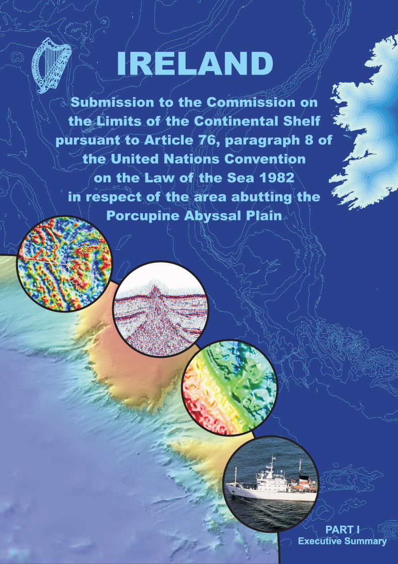
IRELANDSubmission to the Commission on
the Limits of the Continental Shelf
pursuant to Article 76, paragraph 8 of
the United Nations Convention
on the Law of the Sea 1982
in respect of the area abutting the
Porcupine Abyssal Plain
PART IExecutive Summary
PART IExecutive Summary
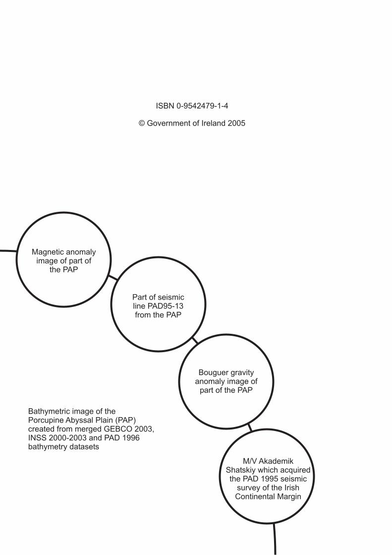
Magnetic anomalyimage of part of
the PAP
Part of seismicline PAD95-13from the PAP
Bouguer gravityanomaly image of
part of the PAP
M/V AkademikShatskiy which acquiredthe PAD 1995 seismic
survey of the IrishContinental Margin
Bathymetric image of thePorcupine Abyssal Plain (PAP)created from merged GEBCO 2003,INSS 2000-2003 and PAD 1996bathymetry datasets
© Government of Ireland 2005
ISBN 0-9542479-1-4
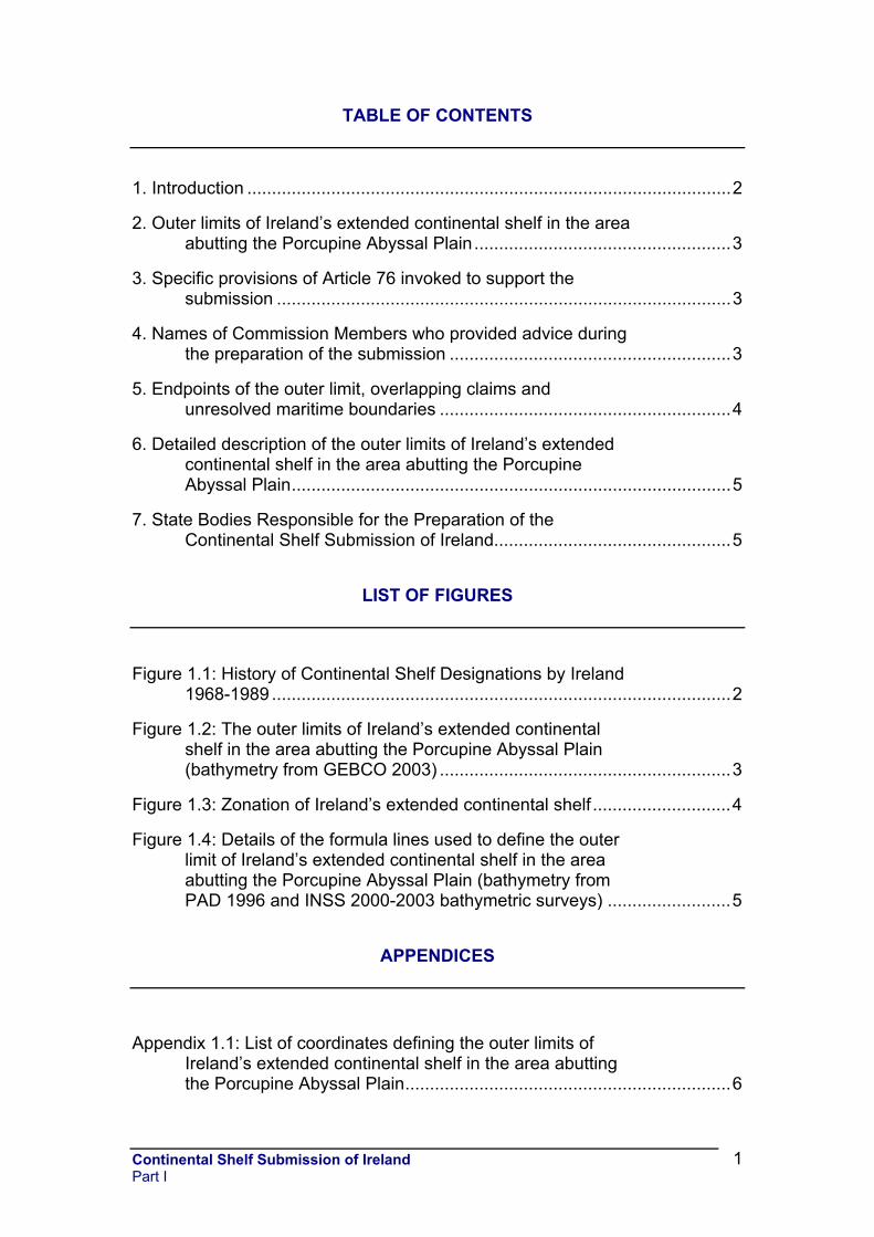
TABLE OF CONTENTS
1. Introduction ..................................................................................................2
2. Outer limits of Ireland’s extended continental shelf in the area abutting the Porcupine Abyssal Plain....................................................3
3. Specific provisions of Article 76 invoked to support the submission ............................................................................................3
4. Names of Commission Members who provided advice during the preparation of the submission .........................................................3
5. Endpoints of the outer limit, overlapping claims and unresolved maritime boundaries ...........................................................4
6. Detailed description of the outer limits of Ireland’s extended continental shelf in the area abutting the Porcupine Abyssal Plain.........................................................................................5
7. State Bodies Responsible for the Preparation of the Continental Shelf Submission of Ireland................................................5
LIST OF FIGURES
Figure 1.1: History of Continental Shelf Designations by Ireland 1968-1989 .............................................................................................2
Figure 1.2: The outer limits of Ireland’s extended continental shelf in the area abutting the Porcupine Abyssal Plain (bathymetry from GEBCO 2003) ...........................................................3
Figure 1.3: Zonation of Ireland’s extended continental shelf ............................4
Figure 1.4: Details of the formula lines used to define the outer limit of Ireland’s extended continental shelf in the area abutting the Porcupine Abyssal Plain (bathymetry from PAD 1996 and INSS 2000-2003 bathymetric surveys) .........................5
APPENDICES
Appendix 1.1: List of coordinates defining the outer limits of Ireland’s extended continental shelf in the area abutting the Porcupine Abyssal Plain..................................................................6
Continental Shelf Submission of Ireland Part I
1

1. Introduction Ireland first formally claimed a limited area of continental shelf in 1968 by means of designation by statutory order made pursuant to the Continental Shelf Act 1968. This was followed by a series of westward-progressing continental shelf designations during the 1970s, culminating in the 1976 designation (yellow on map) which reached 25°W. This was subsequently modified by the 1989 designation (Statutory Instrument No. 141 of 1989 – grey on map) which gave effect to the Agreement of 7 November 1988 between Ireland and the UK on delimitation of areas of the continental shelf between the two countries.
Figure 1.1: History of Continental Shelf Designations by Ireland 1968-1989
Work on preparing Ireland’s submission to the United Nations
Commission on the Limits of the Continental Shelf (CLCS) began in 1994 with budget sanction given for a Continental Margin seismic survey in 1995 and a Continental Margin bathymetric survey in 1996.
Ireland ratified the 1982 United Nations Convention on the Law of the Sea (UNCLOS) on 21 June 1996 and it entered into force with respect to Ireland on 21 July 1996.
Data processing, analysis, interpretation and compilation have continued until 2005, in parallel with two sets of quadrilateral discussions with neighbouring States to the NW (Faroe Islands/Denmark, Iceland, Ireland and the UK) and to the SW (France, Ireland, Spain and the UK).
Continental Shelf Submission of Ireland Part I
2
2. Outer limits of Ireland’s extended continental shelf in the area abutting the Porcupine Abyssal Plain
Figure 1.2: The outer limits of Ireland’s extended continental shelf in the area abutting the Porcupine Abyssal Plain (bathymetry from GEBCO 2003)
The present submission deals only with the outer limits of the continental shelf in the area abutting the Porcupine Abyssal Plain, from foot of slope (FOS) profile 46 to FOS profile 60. 3. Specific provisions of Article 76 invoked to support the submission The outer limits contained in this submission are based on the provisions of both Article 76.4 (a)(i) and 76.4 (a)(ii) of UNCLOS. 4. Names of Commission Members who provided advice during the preparation of the submission Ireland was assisted in the preparation of this submission by Mr. Peter F. Croker, member of the Commission on the Limits of the Continental Shelf (1997-present). No advice was provided by any other members of the Commission.
Continental Shelf Submission of Ireland Part I
3
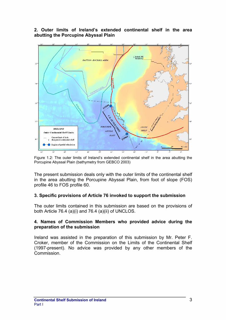
5. Endpoints of the outer limit, overlapping claims and unresolved maritime boundaries
Figure 1.3: Zonation of Ireland’s extended continental shelf
Due to ongoing discussions with neighbouring States with regard to portions of the Irish Designated Continental Shelf Area to the northwest and the southwest, Ireland has elected to split its submission. The partial submission is made in respect of the area abutting the Porcupine Abyssal Plain (marked as Zone B in Figure 1.3 above). It constitutes the first part of Ireland’s complete submission of information on the limits of its continental shelf beyond 200 nautical miles from the baselines from which the breadth of the territorial sea is measured.
Having regard to Article 76, paragraph 10 and Article 9 of Annex II of UNCLOS, and in accordance with paragraph 3 of Annex I to the Rules of Procedure of the Commission, in order not to prejudice unresolved questions relating to the delimitation of boundaries between Ireland and some of its neighbours in other portions of the extended continental shelf claimed by Ireland, submissions in respect of those other portions (Zone A and Zone C) will be made at a later date.
Details of the most northerly and southerly points (endpoints) of the outer limit in respect of which this submission is made, and the corresponding foot of slope points from which they are measured (FOS46 & FOS60), have been communicated to the governments of the Faroe Islands/Denmark, France, Iceland, Spain and the UK. It is the view of Ireland that the
Continental Shelf Submission of Ireland Part I
4
consideration of this partial submission by the CLCS will not prejudice the question of delimitation of boundaries in either Zones A or C.
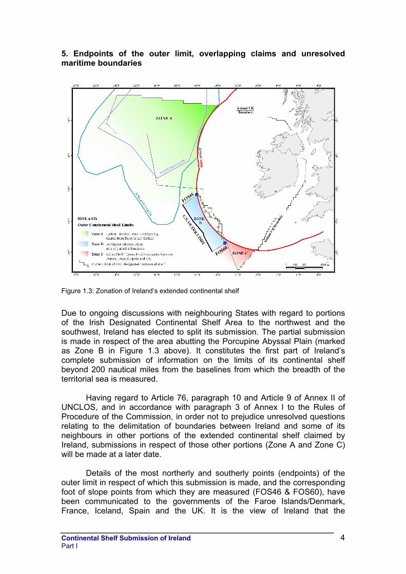
6. Detailed description of the outer limits of Ireland’s extended continental shelf in the area abutting the Porcupine Abyssal Plain
Figure 1.4: Details of the formula lines used to define the outer limit of Ireland’s extended continental shelf in the area abutting the Porcupine Abyssal Plain (bathymetry from PAD 1996 and INSS 2000-2003 bathymetric surveys)
A total of 15 foot of slope points (FOS 46 to FOS 60) have been picked along the Porcupine Ridge-Goban Spur margin. From these FOS points an outer limit based on the FOS+60 nautical miles (M) formula (Hedberg formula) has been generated. On seismic lines PAD95-12 and PAD95-13 (corresponding to FOS profiles 46 and 50 respectively), sufficient sediment thickness has been demonstrated to allow the application of the 1% sediment thickness formula (Gardiner or Irish formula). The final outer limits consist of a series of straight lines, as provided for in the Convention being not more than 60M long, which join points along the Gardiner or Hedberg lines. The coordinates of these points and the lengths of the connecting straight lines are listed in Appendix 1.1. 7. State Bodies Responsible for the Preparation of the Continental Shelf Submission of Ireland This submission, together with all maps, figures, enclosures, appendices and databases were prepared by the Petroleum Affairs Division of the Department of Communications, Marine and Natural Resources of Ireland, which has statutory responsibility for Ireland’s Continental Shelf.
Continental Shelf Submission of Ireland Part I
5
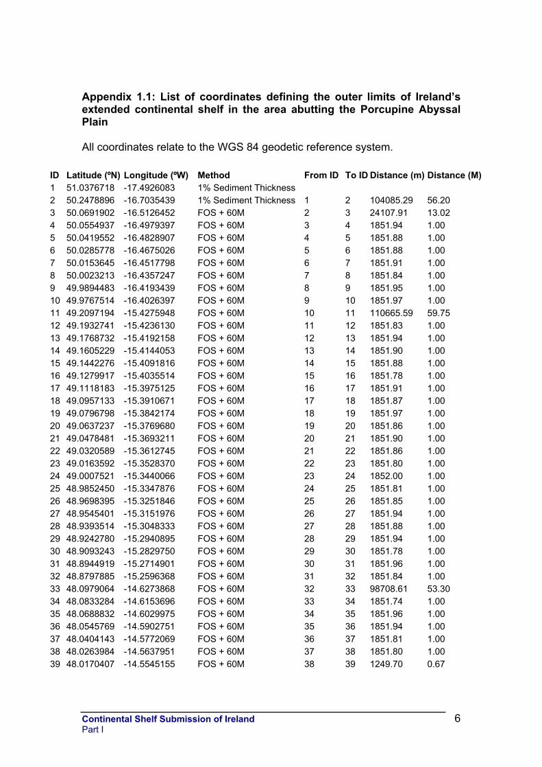
Appendix 1.1: List of coordinates defining the outer limits of Ireland’s extended continental shelf in the area abutting the Porcupine Abyssal Plain All coordinates relate to the WGS 84 geodetic reference system.
ID Latitude (ºN) Longitude (ºW) Method From ID To ID Distance (m) Distance (M)1 51.0376718 -17.4926083 1% Sediment Thickness 2 50.2478896 -16.7035439 1% Sediment Thickness 1 2 104085.29 56.20 3 50.0691902 -16.5126452 FOS + 60M 2 3 24107.91 13.02 4 50.0554937 -16.4979397 FOS + 60M 3 4 1851.94 1.00 5 50.0419552 -16.4828907 FOS + 60M 4 5 1851.88 1.00 6 50.0285778 -16.4675026 FOS + 60M 5 6 1851.88 1.00 7 50.0153645 -16.4517798 FOS + 60M 6 7 1851.91 1.00 8 50.0023213 -16.4357247 FOS + 60M 7 8 1851.84 1.00 9 49.9894483 -16.4193439 FOS + 60M 8 9 1851.95 1.00 10 49.9767514 -16.4026397 FOS + 60M 9 10 1851.97 1.00 11 49.2097194 -15.4275948 FOS + 60M 10 11 110665.59 59.75 12 49.1932741 -15.4236130 FOS + 60M 11 12 1851.83 1.00 13 49.1768732 -15.4192158 FOS + 60M 12 13 1851.94 1.00 14 49.1605229 -15.4144053 FOS + 60M 13 14 1851.90 1.00 15 49.1442276 -15.4091816 FOS + 60M 14 15 1851.88 1.00 16 49.1279917 -15.4035514 FOS + 60M 15 16 1851.78 1.00 17 49.1118183 -15.3975125 FOS + 60M 16 17 1851.91 1.00 18 49.0957133 -15.3910671 FOS + 60M 17 18 1851.87 1.00 19 49.0796798 -15.3842174 FOS + 60M 18 19 1851.97 1.00 20 49.0637237 -15.3769680 FOS + 60M 19 20 1851.86 1.00 21 49.0478481 -15.3693211 FOS + 60M 20 21 1851.90 1.00 22 49.0320589 -15.3612745 FOS + 60M 21 22 1851.86 1.00 23 49.0163592 -15.3528370 FOS + 60M 22 23 1851.80 1.00 24 49.0007521 -15.3440066 FOS + 60M 23 24 1852.00 1.00 25 48.9852450 -15.3347876 FOS + 60M 24 25 1851.81 1.00 26 48.9698395 -15.3251846 FOS + 60M 25 26 1851.85 1.00 27 48.9545401 -15.3151976 FOS + 60M 26 27 1851.94 1.00 28 48.9393514 -15.3048333 FOS + 60M 27 28 1851.88 1.00 29 48.9242780 -15.2940895 FOS + 60M 28 29 1851.94 1.00 30 48.9093243 -15.2829750 FOS + 60M 29 30 1851.78 1.00 31 48.8944919 -15.2714901 FOS + 60M 30 31 1851.96 1.00 32 48.8797885 -15.2596368 FOS + 60M 31 32 1851.84 1.00 33 48.0979064 -14.6273868 FOS + 60M 32 33 98708.61 53.30 34 48.0833284 -14.6153696 FOS + 60M 33 34 1851.74 1.00 35 48.0688832 -14.6029975 FOS + 60M 34 35 1851.96 1.00 36 48.0545769 -14.5902751 FOS + 60M 35 36 1851.94 1.00 37 48.0404143 -14.5772069 FOS + 60M 36 37 1851.81 1.00 38 48.0263984 -14.5637951 FOS + 60M 37 38 1851.80 1.00 39 48.0170407 -14.5545155 FOS + 60M 38 39 1249.70 0.67
Continental Shelf Submission of Ireland Part I
6