Embed Size (px)
Citation preview
78 Articles Section
IBRU Boundary and Security Bulletin Spring 1998 ©
Ireland and the Rockall Dispute: An Analysis of Recent Developments
Clive R. Symmons
Introduction
The legal issues surrounding the remote Atlantic rock of Rockall have been a long-standing saga for Ireland, centring on what maritime zones such a minuscule1 and distant2 insular formation may generate. They have progressively escalated from an essentially bilateral dispute between the UK and Ireland3 to what is now a major quadrilateral dispute between the UK, Ireland, Denmark (on behalf of the Faeroes) and Iceland,4 and involving issues on seabed rights which no longer remain realistically linked to the effect of mere ownership of the rock.
In terms of ownership, the rock is undeniably British;5 and none of the other disputants has actually laid any claim to it. Certainly Iceland and Denmark appear never to have challenged British title there.6 Ireland, however, has perhaps manifested a slight change in position from that of reserving its position over the rock (in the 1970s7) and treating its status as irrelevant to generation of the major maritime zones – to the more hawkish position in the late 1980s of outrightly ‘rejecting’ purported British sovereignty over the rock.8
In the British/Irish context the question of ownership of the rock (and its “immediate surrounds”) was stated to be a “totally separate issue” from that of seabed delimitation in the area which was agreed upon between the UK and Ireland in the 1988 Continental Shelf Delimitation Agreement;9 and it was to be solved by “subsequent political discussion or otherwise.”10 This still seems to be the position in the Anglo-Irish context. For as has been recently stated in the Dáil:11
The issue of Rockall has in the past been a source of some public and political controversy in both Ireland and in the United Kingdom. Much of that controversy was due to unresolved fears on either side regarding the division as between the two countries in the sea area around that rock. ...In particular, jurisdiction over Rockall – the claim to which is contested by Ireland – was thought to be central to the mineral rights in the adjacent seabed,
as well as to national fishing rights in the surrounding seas [emphasis added].
The recent Irish statement implies that Ireland still considers the status of the rock itself to be a live issue as it goes on to say: “Both sides remain aware of the continuing position of their counterpart in the matter [of jurisdiction over the rock].”12 But as yet there appears to have been no “political discussion” about the title issue concerning the rock; and it is interesting to note that in the recent British press release of 21 July 1997 – following the dramatic British change of position on accession to the 1982 LOSC – it is stated that the “UK’s title to Rockall will not be affected” and that the island “will remain part of Scotland” (under the 1972 Island of Rockall Act). And, in fact, the rock will “remain well within the revised [UK 200 -mile] fishery limits” which have now fallen back to the more easterly island of St Kilda.13
Rockall and its Effect on Continental Shelf Claims
A concern for Ireland – as also for Denmark and Iceland – in the past has been the claimed potentiality that Rockall might not only generate as an “island”14 a vast Atlantic continental shelf for the UK – as was foreshadowed in the Island of Rockall Act15 – but also (albeit to a lesser degree) might be used as a relevant basepoint to the UK’s advantage in any continental shelf delimitation in the area.16 For the UK’s past position was strongly in favour of using all its islands to best advantage, including a strict median line position17 relative to them.
In the light of this, and the fact that since the ‘Rockall dispute’ originated, the 1982 LOSC has deprived through Article 121(3),18 uninhabitable and economically worthless “rocks” of the capacity to generate continental shelf or 200-mile EEZs (or fishery zones) for the owner State, it is not surprising that British claims to continental shelf in the Rockall region increasingly tended to emphasise an alternative basis of claim – namely that the Rockall Plateau and its environs were a natural prolongation of the Scottish landmass.19 And, indeed despite some possible Irish interpretations to the contrary,20 the UK did not rely on Rockall relative to neighbouring
Articles Section 79
IBRU Boundary and Security Bulletin Spring 1998 ©
States for median line purposes in its 1974 continental shelf designation21 in the Rockall Region.
This general tendency no doubt reflected the British concern that it was unwise in the context of the new law of the sea provision in Article 121(3) of the LOSC22 to put too many eggs into the ‘Rockall basket’. In other words , in more recent times, Rockall has been viewed even by the UK as having little or no part to play in any agreed settlement of the seabed dispute in the region, which, in fact, hangs more realistically on differing interpretations of the concept of “natural prolongation” from the shores of the regionally-involved parties.23
For this reason, the (now overridden) 1996 British statement (referred to below) announcing postponement of any British accession to the LOSC, because of the threat to Rockall’s status under that convention, was largely of academic interest in terms of the seabed (continental shelf) claims in the Rockall region.24
Not surprisingly, the 1988 Anglo-Irish Continental Shelf Delimitation Agreement25 completely ignored any effect from Rockall on the stepped line there agreed as dividing the respective British and Irish
seabed in the area.26 As the latest Irish Dáil statement confirms, this Agreement reflects the Irish “understanding of the law” (i.e., Article 121(3) of the LOSC); and the delimitation was “agreed without reference to Rockall”.27
In similar fashion, the unilateral actions of Denmark and Iceland in 1985 designating for each State vast swathes of seabed in the Rockall region – which overlapped then (as now) not only with each other, but also with the existing British and Irish claims28 – paid no legal regard to Rockall. This attitude was consistent with their past official statements and protests over conflicting designations in the region.29
Recent Irish Action Exacerbating The Seabed Dispute In The Rockall Trough
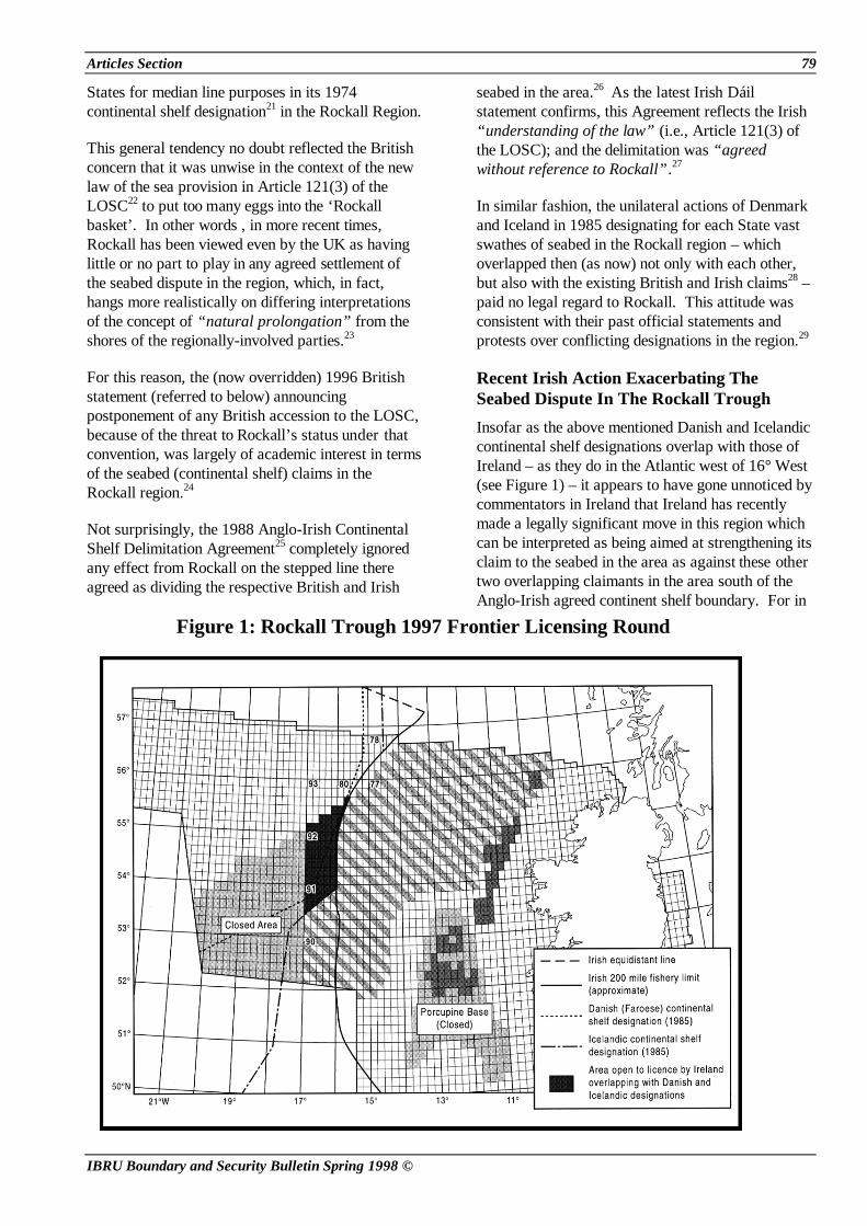
Insofar as the above mentioned Danish and Icelandic continental shelf designations overlap with those of Ireland – as they do in the Atlantic west of 16° West (see Figure 1) – it appears to have gone unnoticed by commentators in Ireland that Ireland has recently made a legally significant move in this region which can be interpreted as being aimed at strengthening its claim to the seabed in the area as against these other two overlapping claimants in the area south of the Anglo-Irish agreed continent shelf boundary. For in
Figure 1: Rockall Trough 1997 Frontier Licensing Round

80 Articles Section
IBRU Boundary and Security Bulletin Spring 1998 ©
the Irish “Frontier Licensing Round” on the Rockall Trough region30 announced in March 1996, about three-quarters of the Irish-claimed Trough was opened up to exploration.
In amongst the most distant quadrants opened up for licence in this huge area of almost 150,000 square kilometres were number 78, 80, 90, 91, 92 and 93.31 The entire quadrants of these were opened to licence in the case of blocks 91 and 92 as well as part of quadrants 78, 80 and 93 to the north and most of the blocks within quadrant 90 (where, the southernmost designation line shaves off the southern part in diagonal fashion) (see Figure 1).
All these quadrants abut the contending claims of Iceland and Denmark. For example, in quadrant 78 one (at least) of the blocks appears to come very close to the (here) more expansive Icelandic (as compared with Danish) claims closely skirting the Irish 200-mile limit. It may be noted that the Icelandic claimed boundary in this sector is based on the (perceived) Irish-claimed 200-mile fishery limit; and as Ireland has never published co-ordinates for the full 200 mile ‘Atlantic arc’ of its 200-mile fishery zone, the area of overlap in this area can only be approximately estimated.32
Four however, of the above-mentioned quadrants are particularly interesting and significant from a legal point of view, namely quadrants 91, 92 and 93 and also quadrant 80 (to a lesser degree). For all these most westerly areas opened up to licence trespass to a greater or lesser degree over the previously-claimed easterly limits of the respective Danish and Icelandic designations, Iceland suffering more heavily because of its more expansive limits as compared with Denmark.33 Not surprisingly, all the successful applicants in this last licensing round have wholly avoided these overlapping area quadrants; and even in quadrants having no overlap, have chosen blocks in undisputed areas standing well back from the disputed ‘grey’ areas, (e.g. in quadrants 77/78 (consortium of Shell, Statoil and BP), and quadrant 83 (Phillips (with Elf) as well as Saga, Total Statoil and Shell (see Figure 1).
It may be that the areas chosen were based on geological rather than political considerations; but the situation may also evidence the well-known commercial principle that oil companies will not risk taking up licences in seabed areas claimed by another State or other States34 (unusually, in this case, effectively a three-way overlap of claims); and it makes the confident Irish (and, indeed, British)
official statements on exploitation potential following the 1988 Anglo-Irish continental shelf delimitation Agreement now sound very hollow.
It was also then confidently stated in the Dáil that the Danish/Icelandic overlaps only really impinged on the British side of the 1988 agreed Anglo-Irish boundary; and that (in some mysterious way), the British sector shielded the Irish sector from being affected by these rival claimants.35
It is possible to conclude that the opening up to licensing by Ireland of zones inside the above-mentioned disputed Rockall Trough zones was not based on commercial consideration alone, and that an ulterior or additional motive may have been to attempt to consolidate its claim to its presently -designated areas within these disputed zones. In any case, a most deliberate type of Irish policy has resulted, going beyond that of the simple (and formal) action of counter-designation over an existing seabed designation of another State. For this latest action enters the more contentious realm of practical State activity – namely relating to exploration (and so potential exploitation) of seabed in over-lapping zones.
The more formalistic counter-designation diplomatic ploy (but without more) has already been used by Ireland on an isolated occasion against the UK – in 1977 when the UK had announced the offer of a production licence in a then-disputed seabed area within Ireland.36 It is somewhat ironic that Ireland has now seemingly resorted to the very type of maritime policy which it has itself previously protested about being used against itself in relation to another (then-contested) part of the North Atlantic region.
Not surprisingly, in the case of these recent ‘intrusive’ Irish moves, at least one of the claimants, Denmark (for the Faeroes) swiftly protested (“notified the Irish Department of Foreign Affairs of the matter”) in July 1996 (i.e. soon after the licence round was originally announced); and asserted that Denmark viewed the areas of overlap, as open to licence, to be appertaining to Denmark as part of the continental shelf of the Faeroe Islands in accordance with the applicable rules of international law.37 It may be assumed that Iceland – whose 1985 designations in this particular areas are even more extensive than Denmark’s (and therefore even more affected by the recent Irish licensing round) – may also have protested.38

Articles Section 81
IBRU Boundary and Security Bulletin Spring 1998 ©
It is addedly strange that Ireland has acted in this way since becoming a party to the LOSC (Law of the Sea Convention, 1982) in 1996;39 and it seems to go against past Irish international statements that such counter-measures do not allow one State to “steal a march” against another State40 – and are, in fact, legally ineffective
This writer has maintained elsewhere41 that unilateral tactics, made late in a pending dispute (as in the case here), do infringe the spirit, if not the letter, of Article 83(3) of the LOSC which enjoins States “[p]ending agreement” on a continental shelf delimitation, to “make every effort to enter into provisional arrangements of a practical nature, and, during this transitional period, not to jeopardise or hamper the reaching of a final agreement”. For such measures as used so recently by Ireland, being wholly unilateral, are not part of such a provisional “agreement”, and, what is worse, actually tend to “jeopardise or hamper the reaching of a final agreement” – a course which Article 83(3) of the LOSC forbids.42
It is not insignificant that when the Irish Minister of State, Mr Stagg, announced the last (1996/1997) exploration round licences in June 199743 whilst welcoming “the number and location of blocks applied for”, including “bids along both the western and eastern margins of the Trough”, made no comment on the fact that there had been no take-up of blocks in the disputed area. He also made the “further announcement” that [the rest of] the Rockall Trough was “remaining closed to exploration licensing for the present”. Thus, for example, the seabed areas west of the 1996/1997 Frontier Licensing Round in quadrants 90, 91 and 92 – which almost totally fall with presently-designated Icelandic/Danish limits – have remained closed in the most recent (1977/1978) round.44 A possible interpretation of this is tacit Irish acknowledgement – in the light of diplomatic protests and the area’s disputed status – of the legal commitments for Ireland which result from the LOSC.
Rockall And Its Effect On 200-Mile EEZ/Fishery Zone Claims: The 1997 British ‘Pull-Back’
The Past Situation
It is this aspect of the ‘Rockall dispute’ which most directly hinged upon the status of the rock itself, as without the aid of the rock as a basepoint, the UK could make no 200-mile fishery zone claims in the North Atlantic beyond existing mainland-oriented or
off-shore Scottish island basepoints;45 whereas, as seen above, in the case of British continental shelf claims in the Rockall region the main UK legal justification has not been based on Rockall’s status itself. In other words, Rockall has been vital to further expansion of British 200-mile fishery limits – far beyond that generated by the Scottish shoreline or its off-shore islands (including the far-flung St Kilda);46 and up to 1997, the UK has consistently upheld Rockall’s entitlement in its own right to generate such a zone.
With the advent of 200-mile exclusive fishery zones in the context of the European Community in the mid-70s, it was soon confirmed that the UK had utilised Rockall under its impending legislation, the Fishery Limits Act, 1976 – whether to 200 miles from it or to a median line position around it.47 The net effect of this policy in the past (i.e. until July 1997)48 has been to create a full span of British fishery waters radiating from , and to the west, of Rockall, with overlapping areas to the south and north-west and north-east thereof caused respectively by the declared 200-mile fishery (or EEZ) limits of Ireland, Iceland and Denmark (Faeroes).49
All three of the above-mentioned States have in the past rejected – expressly or implicitly50 – the right of Rockall to generate a 200-mile zone for the UK. Consequentially, they have each deliberately ignored any effect Rockall may have in designating their respective 200-mile fishery zones (in the case of Ireland and Denmark) or EEZ (in the case of Iceland).
Ireland, of course, was one of the strongest advocates during the UNCLOS III negotiations for a provision to be inserted depriving uninhabitable rocks from generating such zones.51 As the 1996 official Irish statement in the Dáil emphasises, 52 Ireland has “over the past three decades, been involved in a process of clarification of [such] issues”. Accordingly, Ireland has not only protested (as seen) against the imposition of the British 200-mile Rockall-based claim, but has also even rejected imposition of a 12-mile fishery zone (or territorial sea)53 around the rock. And since it has ratified the LOSC – on 21 July, 1996 – Ireland has “formally accepted” Article 121(3) (depriving “rocks” of the major maritime zones) as a “statement of the international law on the matter.”54
Despite such past opposition to British use of Rockall for generation of a fishery zone, in the case of the two EU members – Ireland and Denmark –

82 Articles Section
IBRU Boundary and Security Bulletin Spring 1998 ©
there was something of a dilemma here in the context of the EU fisheries policy. For when Rockall is deprived of its capacity to generate a 200-mile zone for the UK – and consequentially loses its enhanced projection of the EU common fishery area – prima facie other EU member States would also suffer the loss as the present area would largely55 revert to high sea status in which freedom of fishing for all States would theoretically entail. Indeed, there were press reports in the mid-70s, at the time that EU moves were being made for a concerted declaration of 200-mile fishery zones, that Ireland agreed to Rockall being used as a reference point for determining fishery limits only on a provisional basis and on the understanding that its future seabed claims in the area would not be prejudiced.56
The 1996 British Statements on the Rockall-based Fishery Zone.
For some time the Rockall question was quiescent in the UK, as elsewhere.57 However, this situation changed on 20 June 1996, when Lord Kennet asked Baroness Chalker the following question:58
Can [she] confirm as has been reported, that a recently discovered obstacle is a belief by one Member of the Government that the fisheries around Rockall will be affected if we sign up to the [1982] Convention?
In her reply at the time, Baroness Chalker, having mentioned that the “Rockall fisheries” was a matter of concern to the UK and that this was why the UK was “continuing to study the legal implications to make sure that [it gets] things right”,59 replied:60
While there is so much uncertainty around this is not the time to amend unilaterally the British fisheries limits, which would obviously be required if [the UK] were to bring them into line with UNCLOS. My noble friend will be well aware that that is the reason.
Despite this (first) rather opaque official reply, stressing “uncertainty” (presumably as to Rockall’s status in customary international law61) the fact that the UK would be “obviously required” to amend British fishery limits in the area “if [the UK] were to bring them into line with UNCLOS” ,62 seemed even then to officially acknowledge that Rockall would be deprived of a 200-mile fishery zone under the LOSC provision in Article 121(3) relating to uninhabitable “rocks”, as many commentators have speculated.63 Indeed, it may be said that whatever
the ambiguities that reside in the wording of Article 121(3), Rockall clearly comes within its ambit.64
It seems that Lord Kennet also (rightly) thought that the Baroness’s statement was less than clear; for less than a month later (on 5 July 1996) he asked a supplementary question65 enquiring “what recent ‘uncertainties’ concerning the fisheries around Rockall have arisen to cause [the British Government] not to accede to the UN Convention on the Law of the Sea”, and, more specifically, “[I]n what ways UK fishery limits fail to coincide with the UN Law of the Sea provisions”.66 In her reply on this occasion, the Baroness was at last more specific, citing descriptively the relevant aspect of the LOSC. As she replied: 67
Measuring British fishery limits from Rockall is believed to be inconsistent with the Convention’s provision that rocks which cannot sustain human habitation or economic life of their own shall have no exclusive economic zone.
Reading the two British statements together, therefore, it appears that the British (then Conservative-led) Government had publicly acknowledged that accession to the LOSC would bring with it an inevitable obligation to pull back the existing Rockall-based fishery zone to internationally permissible baselines68 under the Convention.
The above British statements indicated clearly that it was because of Rockall (and seemingly then for this sole reason69) that the UK Government had “concluded that now [i.e., 1996] is not an appropriate time to accede” to the LOSC.70 Previously it was at least implicit from parliamentary replies in 198271 that Rockall – and its dependent maritime zones – had been a reason, albeit a subsidiary one, militating against even British signature of the LOSC.72 At least one recent British commentator has seemingly ignored this past straw in the wind.73
The wording of the British statements – including the affirmation that “[t]he timing of accession remains under review and Parliament will be informed as soon as the Government have taken a decision”74 – indicated that even then the UK Government had not peremptorily ruled out eventual accession because of Rockall (as indeed the recent Irish Dáil reply supposes).75 For it was implicit that at some future point of time – after it had studied the “legal and practical implications”,76 even the Conservative

Articles Section 83
IBRU Boundary and Security Bulletin Spring 1998 ©
Government would have accepted the inevitability of giving up the Rockall-based 200-mile fishery zone.77
The British statement was especially interesting in relation to such delayed action. For it is arguable that the UK – already then – had an international legal obligation to amend its Fishery Limits Act78 in respect of Rockall’s present 200-mile zone inasmuch as Article 121(3) of the LOSC may be said to form part of the corpus of customary international law79, particularly now that the Convention has come into force for the ratifying States.80 And it has rightly been pointed out that behind the reason for non -accession in 1996 was “an implicit assumption that Article 121(3) [of the LOSC] does not represent a rule of customary international law”.81
Certainly other disputants in the Rockall region are on record as seeing Article 121(3) as already reflective of customary international law.82 And most recently Ireland has re-affirmed in the Dáil83 that Article 121(3) “represents the view of the majority of the world’s states” as expressed either in negotiations [at UNCLOS III] in the 1970s and/or by ratification of or accession to the Convention. By contrast, in the past at any rate, the UK seems to have opportunistically stuck to the position that Article 121(3) did not have customary law status.84
As matters stood in 1996, therefore, it appeared that the UK had pro tempore decided to hang on to its dubious maritime claim in a matter where politically sensitive (i.e., Scottish) issues obviously arose, even though, as, the more recent British statement of 1997 points out, no significant Scottish fishery interests are at stake here.85
However, the comparative lack of fisheries interest in the Rockall region does not mean that the EU86 lacks a collective vested interest in keeping the Rockall-based fishery limits intact to preserve the size of the common fisheries area – one of the very few areas thereof where the outer limits can extend to the full 200 miles without encroachment from neighbouring States.
It is for this reason that Ireland has in the past faced the dilemma that if it contests the right of Rockall to generate any continental shelf rights for the UK, it must also logically contest its right to generate 200-mile fishery zone (despite general disadvantage to itself via the EU perspective), especially now that the new LOSC has encapsulated both seabed and water column rights into the same composite 200-mile zone, the EEZ.87 Denmark theoretically has the
same dilemma; though despite this it still holds to its position that Rockall is not entitled to such a zone.88 The fourth contender in the Rockall region, Iceland, of course, being outside the EU, is not concerned in this way.
The Change of British Policy in 1997
Following the General Election in 1997 in the UK, and the installation of a Labour-led Government, some rapid changes became evident in British foreign policy and the British viewpoint on international law generally.89 One of the most important of these changes was in the sphere of the law of the sea – and affecting Rockall.
This became evident from a parliamentary answer by the British Foreign Secretary, Robin Cook in the House of Commons on 21 July 199790 when he announced the new British Government had “decided to accede” to the LOSC later that month. But he added this important rider:91
The United Kingdom’s fishery limits will need to be redefined based on St Kilda, since Rockall is not a valid base point for such limits under Article 121(3) of the Convention.
An accompanying press release92 reiterated that British accession would mean that “measuring of British fishery limits from Rockall is incompatible with the provisions of the Convention”, spelling out (as the substance of Article 121(3) of the LOSC provides) that “Rockall is incapable of sustaining human habitation.” In consequence of these announcements as to the inevitable pull-back of the existing British 200-mile zone from Rockall, it was stated that an order in Council would be made “at the first opportunity”.93
The gist of the pull-back of the British zone from Rockall was that Rockall should be eliminated as a basepoint and the more easterly islet of St Kilda used instead. This amounts to a loss of some 60,000 square miles. This change required an amendment to the existing Fishery Limits Act of 1976 (as had been mooted the previous year)94 so that the new statutory provision would “come into force at the same time as the Convention”,95 i.e., on the actual date of British accession.
Accordingly, and with commendable speed, on 22 July 1997, an amending Fisheries Limits Order (1997)96 was promulgated (under powers in s.1(2) of the 1976 Act) which was explicitly and solely aimed (see the Explanatory Note) at “bring[ing] British

84 Articles Section
IBRU Boundary and Security Bulletin Spring 1998 ©
fishery limits into conformity” with the LOSC. Paragraph 2 of the new Order declared that between the appropriate points to the southern and northern sides of the “Rockall zone” (56° 17’ 22”N, 10° 15’ 38”W and 60° 02’ 16”N, 10° 29’ 21”W respectively) British fishery limits would “extend to the lines specified in the Schedule” to the Order, i.e., from these new coordinates.
As to the date of implementation, the new Notice to Mariners97 specified that the order would come into effect “on or about August 24, 1997”. The reason for this delayed effect was evident in the above-mentioned press release which stated: “it will come into force at the same time as the Convention”. Thus the pull-back has immediate effect from the date of the UK’s new treaty obligations.
An analysis of the new coordinates shows that the pre-existing coordinates (laid down in chart Q6353 of 1982)98 are effectively the same at point 43 to the north and point 18 to the south, but from former points 41 (north) and 19 (south) – where a median line from Rockall used to take effect – the new lines both north and south of these trend progressively closer to Rockall itself (see Figure 2) until they strike the open ocean area west of Rockall where the former ‘Rockall arc’ of waters is now replaced by a much truncated 200-mile radius “measured from the baselines from which the territorial sea of St Kilda is measured”.99 The new ‘St Kilda arc’ points are, unlike previously, now listed as coordinates (no doubt to comply with Article 75 of the LOSC).100
The main effect, therefore, of the new arced limits to the west from St Kilda basepoints, is that with the “roll-back on ratification”, they now only extend at the most westerly extent to 14° 15’W beyond Rockall island, whereas previously they extended as far as 19° 53’W from it.101 That is, the British arc now only extends about 36 nautical miles west of the rock, but in doing so still takes in the shallow Rockall bank. This means that some 164 miles of former British (and so also EU) fishery waters have been lost and now revert to high seas status.
However at least one commentator has suggested prior to the latest British moves that such a “roll-back” would have no great bearing on existing fishing practice in the EU.102 And the press release accompanying the latest announcement plays down the economic impact on the home front from the lost waters, now reverting to high seas status by stating that, in 1996, landings of all species from these waters into Scotland represented 0.13% of Scottish
landings by weight and 0.15% by value , and that there will be “no changes to individual fishermen’s catch limits”.103
The Impact of the New (Lateral) Lines on Existing Overlapping Claims Seaward of St Kilda
It was inevitable that once Rockall itself was eliminated as a median line basepoint for the UK’s 200-mile North Atlantic fishery zone, this would have an effect on the existing overlapping fishery zone claims of Iceland and Denmark (Faeroes) where west of 11°W the influence of Rockall begins to bite by casting the respective British lines in a sharply veering northerly direction (against Iceland/Denmark) and southerly (against Ireland). Once Rockall’s influence in this regard ceases, the median lines – now based on St Kilda – would travel in a straighter trajectory.
As matters now stand, therefore, it appears that the former overlap with Icelandic limits in the far north-west arc of the former Rockall zone has now been completely eliminated; and that the formerly overlapping area with the Faeroese zone west of 12°W104 has been made more moderate (though overlaps still remain here to about 5°W with the UK).

Articles Section 85
IBRU Boundary and Security Bulletin Spring 1998 ©
Figure 2: British Fishery Limits

86 Articles Section
IBRU Boundary and Security Bulletin Spring 1998 ©
Likewise in the new lateral limits south of Rockall – where Ireland is affected – west of 11°W, the formerly deeply-plunging British line south-westwards, which cuts across a large part of previous Irish continental shelf designations, now no longer does so to such a marked extent (See Figure 3).
Nonetheless, the overlap of the respective unilaterally-decreed fishery limit lines is still considerable; and it is noteworthy that the British line extends (until the arc from St Kilda begins) south of the already agreed Anglo-Irish ‘staircase’ line in respect of the continental shelf delimitation Agreement of 1988.105 No doubt this has been done to strengthen any British initial bargaining position with Ireland on a fishery boundary.
Obviously an agreed line for fishery limit purposes between the UK and Ireland (and indeed, the UK and Denmark to the north)106 needs now to be actively negotiated. This is now even more feasible, since British discontinuance of reliance on Rockall as a 200-mile basepoint on its seaward side must also inevitably imply that it also cannot be used as a median line basepoint in the lateral directions. Following the 1988 Anglo-Irish Continental Shelf Delimitation Agreement, Ireland expressly stated that the 200-mile fishery boundary had not been dealt with because it was “governed by different rules of international law”.107 This aspect was confirmed in the recent Dáil statement.108
It is apparent from the British 1997 parliamentary statements that after the institution of amended fishery limits the UK would “seek to agree a fisheries boundary with the Republic of Ireland” .109 This is further elaborated on by the accompanying press release110 which states that “[p]roposed talks [with Ireland] will cover the UK/Irish fishery zone north of Ireland where there is a grey zone of overlapping British and Irish fishery limit claims.”
It seems, therefore, that the UK is now seeing an increased urgency in coming to an agreed solution with Ireland on the respective fishery limit boundary. As the writer has indicated elsewhere,111 the present agreed continental shelf boundary (of 1988) in the area could not, in practical terms, ‘double up’ as a 200-mile fishery zone/EEZ boundary because of its uniquely stepped configuration; but it would be in Ireland’s interest to hold out for a smoothed out version of this line to act as a joint continental shelf/200 mile fishery zone (or EEZ) boundary. Consequentially, Ireland would have to retract from
the extravagant claim underlying its still-existing “equitable equidistant line” (the furthermost extent of which line is still enclosed in the British ‘St Kilda’s arc’) – most particularly insofar as it extends more than 200 miles from any Irish basepoints and shoots seaward of Rockall, skirting it to the south just outside Rockall’s 12-mile limit.112
Conclusion
The British pull-back respecting Rockall is one of the comparatively rare instances where a State has actually retracted rather then expanded an existing maritime zonal claim to comply with the developing law of the sea – a recent phenomenon sometimes referred to as “roll-back on ratification”.113 With the retraction of the Rockall based arc of 200-mile fishery limits by the UK, Rockall has become a virtual dead letter in terms of the law of the sea; and so as an irritant to Anglo-Irish relations.
In the light of recent events, Rockall is effectively now merely an unimportant piece of rock with vestigial insular status in international law. Its sole legal importance now for the UK – which, as seen, has reiterated its title to it114 – is that it remains in a technical sense an ‘island’ and therefore continues to generate a territorial sea.115 This 12-mile enclave is still totally contained within the new St Kilda based 200-mile zone116 (as seen above) as Rockall does not even create a further bulge to British limits through its remaining circular 12-mile territorial sea.117
Although, as seen, Ireland still disputes British ownership of the Rock – and the status of its immediately surrounding 12-mile enclave118 – it seems unlikely that the UK would ever make any concession to Ireland on this, the sole legal effect now of Rockall,119 even though, of course, Irish fishing vessels may continue to be excluded by the UK from fishing in this limited zone.120
It is interesting to note from the 1996 Irish statement in the Dáil that Ireland explicitly rules out the rock from even generating a 12-mile territorial sea for the UK on the basis of the uncertain title to the rock.121 In the past, official Irish statements have not always been totally clear or consistent over the extent of territorial waters which Rockall may generate, if at all.122

Articles Section 87
IBRU Boundary and Security Bulletin Spring 1998 ©
Figure 3: Overlapping UK/Irish 200nm Fishery Boundaries in the Rockall Region

88 Articles Section
IBRU Boundary and Security Bulletin Spring 1998 ©
It also seems idle to speculate that St Kilda could be realistically substituted as a bone of contention by Ireland (in terms of its zone-generative capacity) as the equivalent of a second Rockall, i.e., on the basis of St Kilda itself123 being a minuscule islet now effectively uninhabited and so arguably falling into the category of rocks under Article 121(3) of the LOSC. However, St Kilda’s effect on a median line with Ireland is not inconsiderable and this may have been at least partially reflected in the 1988 agreed Anglo-Irish continental shelf line.124 At least one of the other Rockall Plateau contenders, Iceland, appears to have viewed St Kilda as coming squarely within Article 121(3);125 and under the past and (idiosyncratic) Irish policy on British islands,126 St Kilda being well outside the British territorial sea limit and being effectively uninhabited, would not have been deemed an ‘equitable’ basepoint for an equidistance line.127
The recent British pull-back from Rockall also now eliminates the problem for the EU that would have resulted from British retention of the 200-mile limit from same, both in respect for other EU members who have ratified the LOSC and for the EU itself in its institutional capacity if it were to accede to the Convention under Annexe 9 of the LOSC.128
However, as the first part of this article shows, quite apart from the fisheries aspect in the Rockall region, the seabed aspect of the Rockall Plateau area and is environs remains an extremely live and on-going dispute as between the four present contenders – UK and Ireland on the one hand and Iceland and Denmark on the other. It is clear from recent events that in this latter regard the ‘Rockall dispute’ will continue to haunt Ireland for many years to come and will inhibit any further Irish enforcement of its seabed claims in the huge disputed area until an agreement is reached with its two northerly neighbours, Iceland and Denmark (Faeroes).
Notes Reproduced by kind permission of the editors of Contemporary Issues in Irish Law and Politics. 1 For its dimensions, see C.R. Symmons, Ireland and
the Law of the Sea (1993) at p. 122. In terms of both smallness of size (coupled with its singular formation) and great distance from any landfall, it seems to be a quite unique phenomenon in maritime geography.
2 For the relevant distances, see C.R. Symmons, ‘Legal Aspects of the Anglo-Irish Dispute over Rockall’
(1975) 26 NILQ 65, 69. It is pertinent to note that in terms of distance from the nearest mainland (and ignoring off-shore islands), Ireland is nearer (by some 31.15kms) from the Co. Donegal coastline) as compared with Scotland (from Invernesshire).
3 See Symmons, id. and ‘British Off-Shore Continental Shelf and Fishery Limit Boundaries: An Analysis of Overlapping Zones’ (1979) 28 ICLQ 703, 717-729.
4 See C.R. Symmons, ‘The Rockall Dispute Deepens: An Analysis of Recent Danish and Icelandic Actions’, (1986) 35 ICLQ 344.
5 See Symmons, supra, fn. 1 at p. 126 and fn. 2 at p. 68-70. The visit by British private citizens to the rock (such as McClean in 1985) has not been officially viewed as having any relevance to strengthening UK sovereignty there (see, e.g., Hansard (HL) vol. 559, col. 1197 (1994)); nor has the encampment there in June 1997 of three Greenpeace protesters (proclaiming Rockall to be a “Globeland State of Waveland”) been viewed by the British Foreign Office as a challenge to its sovereignty: see Daily Telegraph, 16 June 1997.
6 See Symmons, supra, fn. 1 at p. 129. This is also the British understanding: see, e.g., Hansard (HL) vol. 520, col. 1666 (July 27, 1989). Denmark is clearly on record as accepting British sovereignty there, and implicitly Iceland seems to take the same position. See recently Hansard (HL), vol. 559, col. 1197 (December 13, 1994) (indicating that “three countries” have not made claim to Rockall, including Ireland which “does not recognise the UK's sovereignty over Rockall”). As such, the recent parliamentary statement of Lord Campbell of Croy, Hansard (HL) vol. 573 at col. 457 (“there are claims on it [Rockall] from at least three other countries”) appears to be a loose form of words to cover only Rockall's adjacent maritime zones. Much confusion has in fact been generated by non-lawyers assuming that the real legal problem is that of title to Rockall: see Symmons, supra, fn. 1 at p. 126.
7 See Symmons, supra, fn. 2, at p. 66. 8 See Symmons, supra, fn. 1, at p. 128 and Dáil
Debates, vol. 384, col. 2174 (“[s]uccessive [Irish] governments have rejected purported British sovereignty over the rock and the present government continue to reject this British claim” )
9 See C.R. Symmons, ‘The UK/Ireland Continental Shelf Agreement 1988: A Model for Compromise in Maritime Delimitation’, in C. Grundy Warr (ed.), International Boundaries and Boundary Conflict Resolution (IBRU, Durham, 1990), 387, 399.
10 Dáil Debates, vol. 383, col. 205. See also vol. 381, col. 2540; vol. 384, col. 2174; and vol. 385, col. 1165.
11 Dáil Debates, vol. 469, col. 73 (25 September 1996) in response to several questions asked by Mr Brian Lenihan, TD, on recent British statements on Rockall.
12 Id., at col. 74.
Articles Section 89
IBRU Boundary and Security Bulletin Spring 1998 ©
13 See below fns. 59 et seq. and 114 and press release,
infra fn. 94, p. 2, para. 6. 14 As Rockall is both naturally-formed, and, at some 80
feet high, it is also an island in terms of Article 121(1) of the LOSC. See Symmons, op. cit., supra, fn. 1 at p. 62; and the fact that it may also constitute an uninhabitable “rock” within the meaning of Art. 121(3) of the LOSC cannot detract from this technical status.
15 See op. cit., fn. 1, at p. 127. 16 See id. at pp. 127/8; and supra, fn. 3 at p. 726. For
confirmation of the continuing Danish position on Rockall's status, see infra, fn. 52.
17 See Symmons, supra, fn. 9 at p.392. 18 This states: “Rocks which cannot sustain human
habitation or economic life of their own shall have no exclusive economic zone [EEZ] or continental shelf”.
19 See Symmons, supra, fn. 3 at p. 724. 20 Id. 21 Under the Continental Shelf (Designation of
Additional Areas) Order, 1974 (S.I. No. 1489 (1974) which designated some 52,000 square miles of seabed in the Rockall region. See Symmons, supra, fn. 2 at p. 66.
22 Cf. the Dáil statement, supra, fn. 11, col. 73 relating to "Mineral rights" where use of the past tense implies that now, from the seabed perspective, Rockall has ceased to have any importance in the Anglo-Irish context.
23 See e.g. Symmons, supra, fn. 2 at p. 70 and supra, fn. 4 at pp. 352, 361; Geographic Notes, No. 1, 30 September 1985, p. 8; and G. Marston, 'The UK's Acquisition of the Island of Rockall and its Consequences for the Law of the Sea', p. 7 (unpublished paper delivered at the 5th Anglo-Soviet Symposium of Maritime Law, Moscow, in July 1988).
24 See R.R. Churchill, ‘The UK's Decision to Defer Accession to the UN Convention on the Law of the Sea: A Convincing Move?’ (1997) 12 IJMCL, 110, 115.
25 See Symmons, supra, fn. 9 at p. 398. 26 For an analysis of the Agreement, see Symmons,
supra, fn. 9. See the recent Dáil statement (supra fn. at col. 74) (“that delimitation was agreed without reference to Rockall”)
27 See Dáil Debates, vol. 469, col. 74. 28 See Symmons, supra, fn. 4 at p. 353-354, 366. 29 Id. At p. 347, 356. 30 See Government Information Services Bulletin on
behalf of The Department of Transport, Energy and Communications of 15 March 1996, and 4 June 1997.
31 See Press Release, 15 March 1996, Attachment 11, Areas A and B.
32 As to Iceland's zone, see Symmons, supra, fn. 4, 366. As party to the LOSC, Ireland is obliged to issue a
large scale map or co-ordinates under Art. 75(1) of the LOSC.
33 See again map 1. Also many of the blocks, including the most westerly in quadrants 78, 80, 93 and part of 92 trespass over the then claimed UK 200-mile fishery limits based on Rockall.
34 Cf. the recent protest by Denmark to the UK which reserves a Danish “possible claim” to a small part of a newly-licensed area by the UK near the de facto UK/Faeroese maritime dividing line. To this the UK has responded that it “has no doubts about its sovereign right to license the block” . It appears that the six applicant oil companies – who are aware of the Danish protest – have not yet withdrawn their bids for the disputed area. See Daily Telegraph, 6 December 1997.
35 See Symmons, supra, fn. 9 at p. 403; and Dáil Debates, vol. 384, cols. 2171 and 2194.
36 See Symmons, supra, fn. 3 at p. 724. 37 This is confirmed in a letter to the writer from the
Ministry of Foreign Affairs, Copenhagen, dated 3 December 1996.
38 Iceland's protest policy has been difficult to discover: see Symmons, supra, fn. 3 at p. 729. The writer was unable to get any response from the Icelandic Ministry of Foreign Affairs.
39 See infra, fn. 56 and accompanying text. 40 See Symmons, ‘Outstanding Maritime Boundary
Problems between Ireland and the UK’ in E. Brown and R.R. Churchill (eds.), The UN Convention on the Law of the Sea: Impact and Implementation (1987), 235, 237.
41 Supra, fn. 4 at p. 369. 42 Compare for example, Denmark's stress that its 1985
counter-designation in the Rockall area was merely “provisional” pending agreement: Symmons, supra, fn. 4 at p. 368..
43 See Press Release of Department of Transport, Energy and Communications, 4 June 1997
44 Id., at p. 8. 45 See Symmons, supra, fn. 1 at p. 181 46 See Symmons, supra, fn. 3 at p. 726. On the vital
legal importance of St Kilda now, see infra, fn. 96 and accompanying text.
47 Id., at p. 726. 48 See infra, p. 144. 49 See Symmons, supra, fn. 3, at p. 726-731. The
Anglo-Irish overlap is enhanced by the strange – indeed bizarre – fact that the “equitable equidistant line” declared by Ireland for 200-miles fishery limit purposes in the region extends more than 200 miles from the nearest Irish baselines. It appears this was done for tactical reasons; see Symmons, supra, fn. 41 at p. 237 and infra, fn. 112.
50 For confirmation of the Irish protest, see e.g. Dáil Debates, vol. 296, col. 2572 (“not consistent with applicable principles of international law”) and vol. 313, col. 1350; for the Danish protest – citing the UNCLOS III developments – see The Times, 29

90 Articles Section
IBRU Boundary and Security Bulletin Spring 1998 ©
January 1977. There is no formal record of any Icelandic diplomatic protest, though it is likely there was one. It was confirmed in to the writer (see supra, fn. 39) in 1996 that the Danish position remained unchanged on this; that Denmark still considered Rockall was not entitled to a 200-mile fishery zone or EEZ under international law; and additionally that any Faroese/British delimitation of these zones must not take Rockall into account.
51 See Symmons, op. cit., supra, fn. 1 at p. 80. 52 Supra, fn. 11 at col. 74. 53 See Symmons, op. cit., supra, fn. 1 at p. 79 and
infra, fn. 117 et seq. 54 See the Irish official statement, supra, fn. 11 at col.
74. 55 How large the contraction of the EU fisheries would
actually be depends largely on use of St Kilda as a ‘fall-back’ baseline. See now infra, fn. 123 and accompanying text. The pull-back of the 200-mile baseline to St Kilda has not gone without criticism by British fishery organisations: see Daily Telegraph, 29 July 1997.
56 See The Guardian, 29 January 1977. 57 See Symmons, supra, fn. 1, at p. 196 (“this now
four-sided dispute seems to have gone into a stalemate”).
58 Hansard (HL, vol. 573, cols. 456/7). 59 Id., at col. 457. 60 Id. 61 See infra, fn. 81. 62 Supra, fn. 60 at col. 457 (emphasis added). Whether
St Kilda would legally suffice for this purpose is discussed infra at fn. 125 and accompanying text. In the case of Rockall, though, its 200-mile fishery limits had been in existence for some 20 years (i.e., since 1977). Could this timescale legally preserve its erstwhile status or existing generation of zones? For the possible effect of estoppel and acquiescence in preserving insular basepoints, see C.R. Symmons, ‘Some Problems Relating to the Definition of ‘Insular Formations’ in International Law’, IBRU Maritime Briefing, Vol. 1, No.5 at p. 11, 12; and cf., e.g., the wording of Article 7(4) of the LOSC (relating to low-tide elevations).
63 See infra, fn. 80. 64 Whatever may be the ambiguities in Art. 121(3) of
the LOSC relating to the meaning of “rocks” and habitability etc., there seems no doubt that Rockall is not a marginal case and pre-eminently fits into the definition as laid down: see Symmons op. cit., supra, fn. 1 at p. 82, and B. Kwiatkowska and K. Soons, ‘Entitlement to Maritime Areas of Rocks which Cannot Sustain Human Habitation or Economic Life of Their Own’ (1990), Netherlands Yearbook of International Law, 139, 161; Marston, supra, fn. 23 at p. 1.
65 Hansard (HL), vol. 573, col. 120 (5 July 1996). 66 Id. at col. 120. 67 Id.
68 See infra, fn. 125 on St Kilda’s status for this
purpose and supra, fn. 64 on whether estoppel can preserve the status quo as to existing insular zone claims.
69 Previously the UK was more concerned with other aspects of the LOSC, particularly with those contained in the deep seabed provisions in Part XI. These concerns were seen to have been overcome by the Supplementary Agreement to Pt XI opened for signature at the UN on July 29, 1994. Thereafter it was announced in the UK parliament that the UK would, having voted for the 1994 Resolution, “ratify the Agreement and accede to the Law of the Sea Convention in due course and once the necessary procedures are complete”. It was added that: “[t]he Government’s objections to Part XI of the Convention have been satisfactorily addressed in the new Agreement” and that the “remainder of the Convention is generally helpful to UK interests” (Hansard (HL), vol. 557, col. 29 (20 July 1994). For comment, see D. Anderson, ‘Further Efforts to Ensure Universal Participation in the UN Convention on the Law of the Sea’ (1994) 43 ICLQ, 886, 893, fn. 18; and Churchill, supra, fn. 24 at p. 112.
70 Supra, fn. 67, at col. 120. 71 See Hansard (HC), vol. 27, col. 270 (12 July 1982) –
the query in the House of Lords by Lord Douglas Hamilton as to whether the UK could continue to claim a 200-mile fishery zone around Rockall, St Kilda and the other uninhabited off-shore islands in the light of the LOSC provisions. It was officially replied that the UK was examining the LOSC texts in the light of all UK interests, and that any decision would depend on this examination.
72 See the response to the more specific question as to whether the UK’s signature of the LOSC would “prejudice” the UK’s position on Rockall’s status in any international arbitration. It was officially replied that among the many aspects then being considered was whether and how signature might affect arbitral proceedings involving the Rockall region (Hansard (HC) vol. 28, col. 750 (30 July 1982). The UK appears to have been the only EU State worried about the implications of Article 121(3); though Portugal – which belatedly ratified the LOSC in 1997 – may be considered to have a similar ‘Rockall’ problem relating to three small rocks in a nature reserve (now agreed by Spain to belong to Portugal) lying between the Madeira and Canary Island chain – The Selvagens. Portugal presently claims a 200-mile fishery zones from these islets (subject to delimitation with the Spanish islands), and appears to view them as not being disqualified under Art. 121(3) of the LOSC because one of them has a lighthouse and is inhabited by lighthouse personnel.
73 Churchill, supra, fn. 24 at p. 113 (“[I]n the light of the fact that on no occasion does the [British] government appear publicly to have referred to the possible problem that might be caused by the

Articles Section 91
IBRU Boundary and Security Bulletin Spring 1998 ©
application of Article 121(3) to Rockall, the [British] government’s announcement on 5 July, 1996 will have come to many observers as a surprise” ).
74 Supra, fn. 67 at col. 120. 75 See supra, fn. 11 at col. 74 (“nothing that was said
at either time leads [Ireland] to believe that there has been any fundamental revision of the British position and intentions towards the Convention as [it] understand[s] them”); and id., cols. 74, 75 (“the issue central to these exchanges was one of the timing of the British accession rather than a change of policy which is favourable to accession”).
76 Supra, fn. 60 at col. 457. 77 See Hansard (HL) supra, fn. 67 at col. 121 (“[not] at
the present time”); also the previous reply supra, fn. 60 at col. 457 (“this is not the time to amend unilaterally the British fisheries limits” (emphasis added)).
78 Among the many commentators who have specifically mentioned Rockall as being incapable of generating a 200-mile zone are, e.g., J. Briscoe, ‘The Use of Islands in International Boundary Delimitation’ in Dallmayer and De Vorsey (eds.), Rights to Oceanic Resources (The Hague, 1989), 115, 121; Kwiatkowska and Soons, supra, fn. 66 at p. 161; Marston, supra, fn. 23 at p. 5; R.B. Clark, The Waters Around the British Isles (OUP, 1987), p. 290.
79 See Symmons, supra, fn. 1 at p. 81; and E. Brown ‘Rockall and the Limits of National Jurisdiction of the UK’ (1978), Marine Policy, 208; L.D.M. Nelson, ‘The Delimitation of Maritime Boundaries in the Caribbean’, in D.M. Johnston and P.M. Saunders (eds.), Ocean Boundary Making: Regional Issues and Developments (London, 1988), at pp. 174/5. However, several academic commentators have doubted whether such a customary rule has yet emerged. See e.g., Kwiatkowska and Soons, supra, fn. 66 at p. 139; Fusillo, ‘The Legal Regime of Uninhabited Rocks Lacking an Economic Life of Their Own’ (1978-9), vol. IV, Italian Yearbook of International Law, 47, 57; D. Freestone, ‘Maritime Boundaries in the Eastern Caribbean’, in Grundy-Warr, op. cit., supra, fn. 9, 195, 198.
80 Compare the implication of Lord Kennet’s supplementary question when he asked why there was now uncertainty about Rockall in view of “[British] statements over the years that they accepted [those] parts of the UN Law of the Sea [relating to fisheries] as international customary law”: supra, fn. 67 at col. 120 (emphasis added).
81 Churchill, supra, fn. 24 at p. 113. 82 For the Irish viewpoint on this, see Symmons, op.
cit., supra, fn. 1 at p. 83, and Dáil Debates, vol. 384, cols. 2071/2; also Cremin, ‘The UN Conference on the Law of the Sea’ (1979) 1 Irish Studies, 49, 59; for Denmark, see Symmons, supra, fn. 4 at p. 384; and for Iceland, id. at p. 358 (the Icelandic position is implicit rather than explicit in this regard).
83 Supra, fn. 11 at col. 74. Cf. the wording of question 2
(id. at col. 72) of Mr Lenihan in the Dáil which asked “whether the [Irish] Government will maintain the position that the provision of the UN Law of the Sea Convention relating to rocks which cannot sustain human habitation or economic life are declaratory of existing customary international law...” It is noticeable that the official reply does not clearly state that Article 121(3) now constitutes such customary law, though it implies as much.
84 See, e.g. the reported UK response to the Danish protest in 1977 ((1977) 81 RGDIP 860, 861); and the reference to “uncertainty” in Baroness Chalker’s statement (supra, fn. 62 and accompanying text) above may also relate to this aspect of the Rockall problem.
85 See infra, fn. 104. Nonetheless, when Britain did pull back its 200-mile fishery zone to the basepoint of St Kilda, the alleged reduction of “European” fishing rights in these (now) international waters was criticised by the National Federation of Fishermen’s Organisations (in the UK), alleging that they had not been consulted over the move “surrendering Britain’s fishing rights”: see Daily Telegraph, 29 July 1997.
86 See infra, fn. 129. 87 See Dáil Debates, vol. 296, col. 1574. For detailed
discussion in this, see Symmons, op. cit., supra, fn. 1 at p. 84, 199.
88 See supra, fns.27 and 52 and accompanying text. 89 E.g., on human rights policy and British arms
exports to repressive regimes. 90 Hansard (HC), Written Answers, 21 July 1997, cols.
397, 398, followed by an identical statement by Baroness Symons in the House of Lords a day later on July 22, 1997 (Hansard (HL) Written Answers, 22 July 1997, cols. 155, 156).
91 Id. (HC) at col. 397. 92 “UK Accession to the UN Convention on the Law of
the Sea”, 21 July 1997, p. 2, para. 6. 93 Hansard (HC), supra, fn. 92, col. 397. 94 See Lord Kennet’s supplementary question (supra,
fn. 67 at col. 120), and Baroness Chalker’s reply. 95 Press release, supra, fn. 94, p. 2, para. 5. 96 S.I. No.1750 of 1997. In s.1(2) of the 1976 Act, the
UK’s 200-mile limit can be altered “by Order in Council ... to such other line as may be specified by the Order.”
97 See the Notice to Mariners 3203 (P)/97 issued on August 23, 1997.
98 Strangely, these previous British coordinates were not laid out in statutory instrument as were the Irish in the Maritime Jurisdiction (Exclusive Fishery Limits) Order of 1976.
99 See Notice to Mariners (supra, fn. 99 at p. 2) and the schedule to the Order (supra, fn. 94) between points 25 and 33. For past speculation on how any St Kilda lines might run, see Churchill, supra, fn. 24 at p. 117.

92 Articles Section
IBRU Boundary and Security Bulletin Spring 1998 ©
100 This states in para. 2: “the outer limits of the
exclusive economic zone ... shall be shown on charts of a scale or scales adequate for ascertaining their position” or “[w]here appropriate by lists of geographic coordinates of points”. A large-scale British map (amending map Q6353) is promised to replace the ‘chartlet’ attached to the Notice to Mariners “in due course”.
101 See Figure 2. 102 Churchill, supra, fn. 24 at p. 117. There have also
been occasional attempts by non-EU trawlers to fish within the Rockall area which have led to British enforcement action. One such incident was reported in 1994 (see The Times, 22 March 1994) when the Rex, a vessel registered under the flag of Cyprus, but with an Icelandic skipper, was arrested by a Scottish fishery protection vessel.
103 See supra, fn. 94 at p. 2, para. 6. But compare the 1996 British statement supra, fn. 60 at col. 457 (“The Rockall fisheries is a matter of concern to this country”).
104 See Symmons, supra, fn. 3 at p. 729-731. 105 See Symmons, supra, fn. 9 at p. 396-398. 106 See Symmons, supra, fn. 3 at p. 730, 731. 107 See Dáil Debates, vol. 384, col. 2175. Note also that
even in the pre-Agreement Anglo-Irish maritime boundary situation, when there was merely agreement in principle to refer the question of maritime delimitation to a third party settlement procedure of a judicial nature, this only referred to the continental shelf aspect: see Symmons, supra, fn. 3 at p. 727, 728.
108 Supra, fn. 11 at col. 74 (the 1988 Agreement was “without prejudice to [Ireland’s] position on the jurisdictional question [over Rockall], including the issue of fishing rights”). Any future moves to convert the overlapping zone areas into a full EEZ – so taking in seabed as well as water column rights – would compound the legal problems. It is interesting to note that the Irish Dáil statement implied that Ireland still then contested the 200-mile zone based on Rockall.
109 See supra, fn. 92, (HC) col. 397 and (HL) col. 156. Note Denmark is (strangely) not mentioned in this connection.
110 Supra, fn. 94, p. 2, para. 7. 111 Supra, fn. 1 at p. 199, 200. 112 See Figure 3. 113 See D. H. Anderson, ‘British Accession to the UN
Convention on the Law of the Sea’ (1997) 46 ICLQ 761, 779, who comments that this is a “further example of the kind of “roll-back” which would be welcomed by maritime interests” ; and (id. at fn. 70) that the Order “represents a significant example of State practice in regard to Art. 121(3)”.
114 See supra, fn. 13. 115 See British chart Q6353. 116 Fn. 13. and accompanying text. 117 See Figure 3.
118 See supra, fn. 11 and Symmons, supra, fn. 9 at p.
399. 119 Apart, of course, from a potential 24-mile contiguous
zone. 120 There have been several incidents already involving
British fishery protection vessels warning off Irish fishing vessels for alleged illegal fishing in the Rockall area within such British-claimed limits, the most recent being in May, 1994 (see Irish Times, 6 May 1994). And the Irish Government has protested sporadically at British attempts to enforce British fishery regulations against Irish trawlers in the 12-mile enclave around Rockall (see, e.g., Dáil Debates, vol. 369, col. 1780 and vol. 381, cols. 2123 and 2131). It is unclear whether Ireland formally protested against the imposition of the 12-mile zone itself at the time it was created under the Fisheries Limits Act of 1964.
121 See supra, fn. 11 and id. at col. 74 (Ireland has “likewise not accepted” the UK claim to “a 12-mile territorial sea around Rockall”, a claim which depends “on jurisdiction over the rock”).
122 See Symmons, fn. 1 at p. 42, 62. There has even been an assertion in the Irish Dáil that Rockall is not an “island” in international law and therefore it cannot generate maritime zones “of any kind” (Dáil Debates, vol. 379, col. 412). This, of course, is an overstatement, as Rockall is still technically an island.
123 The St Kilda group is 84 miles from Scotland and about 170 miles east from Rockall. It now has an artificial human presence – some military personnel: see Symmons, supra, fn. 1 at p. 176. Academic commentators have differed as to its status, but have inclined to distinguish it from Rockall; e.g., Marston (supra, fn. 23 at p. 72) states that “considerable doubt” would arise over whether St Kilda (“a much larger feature [than Rockall] which once supported a large population”) would come within the scope of Article 121(3) of the LOSC.
124 Unlike, e.g., in the case of Rockall, the UK seems to have used this islet as a basepoint against Ireland in its 1974 continental shelf designation (see Symmons, supra, fn. 1 at p. 176).
125 See Symmons, supra, fn. 4 at p. 366. Denmark, at least, appears to have allowed it a 200-mile zone in designating its Faeroe-based seabed claim in the region: see Symmons, supra, fn. 4 at p. 354.
126 See Symmons, supra, fn. 42 at p. 236. 127 See Symmons, supra, fn. 9 at p. 397. 128 See Churchill, supra, fn. 24 at p. 120. It seems to be
generally accepted that the EU, although undoubtedly having institutionally-acquired transferred competence in certain fishery matters, i.e., over conservation and management of fish stocks within Atlantic/North Sea 200-mile limits – would be unable to become a full party in respect of maritime delimitation powers without a new declaration of competence. This is because the actual designation

Articles Section 93
IBRU Boundary and Security Bulletin Spring 1998 ©
and declaration of 200-mile fishery limits and boundaries with neighbouring States is presently within the exclusive competence of each Member State: see ‘Future External Fisheries Policy’, COM (76) 500 Final, 23 September 1996, at p. 5. The European Union intends to become a party to the Convention. In 1984 the European Community signed the LOSC, but with an appended Declaration indicating that a “separate decision on formal confirmation would be taken at a later stage”: see D. Vignes, ‘La Communaute europeenne dans le domaine du droit general de la mer’, in T. Treves and L. Pineschi, The Law of the Sea: The European Union and its Member States (eds.) (Kluwer, 1997) 7, 22. In his supplementary question on 5 July, 1996, Lord Kennet raised the EU perspective by asking whether in view of the UK’s common fisheries policy “relating to [such] areas”, the UK Government had consulted with DG XIV of the European Commission (supra, fn. 60 at col. 120). The reply given was that the Government’s position in relation to the LOSC
was “not a matter for the European Commission” and that it did not “consult other outside bodies on the timing of the accession” (id. at col. 121). Cf. the Irish Dáil statement of 1996, supra, fn. 11 at col. 73.
Professor Clive Symmons is a Research Associate in law at Trinity College, Dublin and has taught international law and the law of the sea on both sides of the Irish Sea. He has written widely on these issues, notably in two books: The Maritime Zones of Islands in International Law (Martinus Nijhoff) and Ireland and the Law of the Sea (Round Hall Press, Dublin), as well as his IBRU Maritime Briefing Some Problems Relating to the Definition of ‘Insular Formations’ in International Law: Islands and Low-Tide Elevations. IBRU is indebted to Round Hall Sweet & Maxwell publishers for their kind permission to include this paper, a version which will appear shortly in R.Clark et al (eds) Contemporary Issues in International Law and Politics.