Embed Size (px)
Citation preview
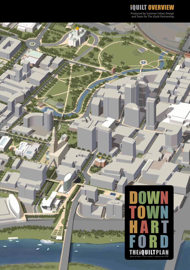
Produced by Suisman Urban Design and Team for The iQuilt Partnership
iQUILT OVERVIEW
© 2012 Suisman Urban Design and The iQuilt Partnership
iQUILT DESIGN TEAM
Suisman Urban DesignwithMichael Vergason Landscape ArchitectsSmith Edwards ArchitectsDomingo Gonzalez AssociatesNelson Byrd Woltz Biederman Redevelopment VenturesRichter and CeganSmart MobilityMaureen Connolly ManagementLeach Consulting
iQuilt Partnership31 Pratt Street Hartford, CT 06103(860) 525-4451
City of Hartford State of Connecticut MetroHartford Alliance Greater Hartford Arts Council Hartford Business Improvement District Bushnell Center for the Performing Arts Metropolitan District CommissionBushnell Park FoundationRiverfront Recapture
iQUILT OVERVIEW
City of Hartford State of Connecticut MetroHartford Alliance Greater Hartford Arts Council Hartford Business Improvement District Bushnell Center for the Performing Arts Metropolitan District CommissionBushnell Park FoundationRiverfront Recapture
January 2012
The Board of Directors of the iQuilt Partnership is pleased to present this Overview of the iQuilt Plan as developed by Doug Suisman of Suisman Urban Design. Working with arts, business, education, and community leaders over the past three years, Doug and his team of talented professionals have helped define a shared vision for downtown Hartford, based on the three themes of walking, culture, and innovation. The iQuilt Plan lays out a strategy and design for making Downtown’s public spaces more enjoyable and walkable, day and night in all four seasons, by linking Hartford’s extraordinary arts and cultural assets and by showcasing the Region’s strengths in cultural and industrial innovation.
The goal is to make Connecticut’s capital city more culturally vibrant, environmentally sustainable, and economically prosperous. The design is visionary, but the means are practical: build on the City’s strengths and previous investments, such as the Riverfront redevelopment; leverage the full potential of its cultural assets, ranked 14th in the nation; integrate funded capital improvements; and focus on projects that are both achievable and transformative.
The iQuilt Plan is not a single project, but an integrated suite of projects -- public and private, large and small -- which can be implemented by different entities in multiple phases. They include a Downtown website, wayfinding signage, and enhanced transit stops as well as new park spaces and public gardens with flowing water bordered by shops and housing. While some of the designs in this overview are very detailed and others only illustrative, the implementation of all are subject to securing appropriate approvals and financing. It’s most important to emphasize that the individual and collective aim of all of the projects is to enhance public space, increase foot traffic on downtown sidewalks, upgrade public transit, implement “green infrastructure”, and promote energy efficient buildings.
In short, the iQuilt Plan will make Downtown the shared “living room” for the City and Region and a magnet for investment and economic development in retail, housing, and commerce thereby enhancing an urban center that attracts visitors, residents, and the talented workforce needed to drive our regional economy. The iQuilt Board looks forward to continued collaboration with all sectors of the community and to implementing the iQuilt vision so that Hartford prospers as the Region’s dynamic urban core. Chuck Shivery, CEO, Northeast UtilitiesChairman, iQuilt Partnership
iQuilt Partnership31 Pratt Street
Hartford, CT 06103(860) 525-4451
www.iquiltplan.org
Andy BessetteTravelers
Charles SheehanMetropolitan District Commission
James CarterCarter Realty, LLC
H. Charmaine CraigKnox Parks Foundation
Eric DanielsRobinson & Cole
Jennifer DiBellaCranmore, FitzGerald & Meaney
David FayBushnell Center for the Performing Arts
Oz GriebelMetroHartford Alliance
Joseph MarfuggiRiverfront Recapture
Cathy MalloyGreater Hartford Arts Council
Robert PainterCity of Hartford
David PanagoreCity of Hartford
Pamela Trotman ReidSaint Joseph College
Charles ShiveryNortheast Utilities
Michael ZaleskiHartford BID
6 7
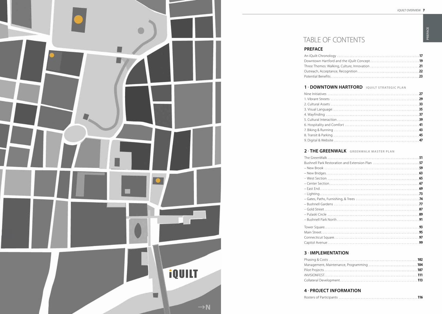
TAbLE Of CONTENTS
iQUILT OVERVIEW
PR
EFA
CE
PREFACEAn iQuilt Chronology . . . . . . . . . . . . . . . . . . . . . . . . . . . . . . . . . . . . . . . . . . . . . . . . . . . . 17Downtown Hartford and the iQuilt Concept . . . . . . . . . . . . . . . . . . . . . . . . . . . . . . . 19Three Themes: Walking, Culture, Innovation . . . . . . . . . . . . . . . . . . . . . . . . . . . . . . . 21Outreach, Acceptance, Recognition . . . . . . . . . . . . . . . . . . . . . . . . . . . . . . . . . . . . . . . 22Potential benefits . . . . . . . . . . . . . . . . . . . . . . . . . . . . . . . . . . . . . . . . . . . . . . . . . . . . . . . . 23
1 . DoWNtoWN HARtFoRD I Q U I Lt S t R At E G I C PL A N
Nine Initiatives . . . . . . . . . . . . . . . . . . . . . . . . . . . . . . . . . . . . . . . . . . . . . . . . . . . . . . . . . . 271 . Vibrant Streets . . . . . . . . . . . . . . . . . . . . . . . . . . . . . . . . . . . . . . . . . . . . . . . . . . . . . . . . 292 . Cultural Assets . . . . . . . . . . . . . . . . . . . . . . . . . . . . . . . . . . . . . . . . . . . . . . . . . . . . . . . . 333 . Visual Language . . . . . . . . . . . . . . . . . . . . . . . . . . . . . . . . . . . . . . . . . . . . . . . . . . . . . . . 35 4 . Wayfinding . . . . . . . . . . . . . . . . . . . . . . . . . . . . . . . . . . . . . . . . . . . . . . . . . . . . . . . . . . . 375 . Cultural Interaction . . . . . . . . . . . . . . . . . . . . . . . . . . . . . . . . . . . . . . . . . . . . . . . . . . . . 396 . Hospitality and Comfort . . . . . . . . . . . . . . . . . . . . . . . . . . . . . . . . . . . . . . . . . . . . . . . 417 . biking & Running . . . . . . . . . . . . . . . . . . . . . . . . . . . . . . . . . . . . . . . . . . . . . . . . . . . . . . 438 . Transit & Parking . . . . . . . . . . . . . . . . . . . . . . . . . . . . . . . . . . . . . . . . . . . . . . . . . . . . . . . 459 . Digital & Website . . . . . . . . . . . . . . . . . . . . . . . . . . . . . . . . . . . . . . . . . . . . . . . . . . . . . . 47
2 . tHE GREENWALk G R E E N WA L k M A S t E R PL A N
The GreenWalk . . . . . . . . . . . . . . . . . . . . . . . . . . . . . . . . . . . . . . . . . . . . . . . . . . . . . . . . . . 51bushnell Park Restoration and Extension Plan . . . . . . . . . . . . . . . . . . . . . . . . . . . . . 57– New brook . . . . . . . . . . . . . . . . . . . . . . . . . . . . . . . . . . . . . . . . . . . . . . . . . . . . . . . . . . . . 59– New bridges . . . . . . . . . . . . . . . . . . . . . . . . . . . . . . . . . . . . . . . . . . . . . . . . . . . . . . . . . . . 63– West Section . . . . . . . . . . . . . . . . . . . . . . . . . . . . . . . . . . . . . . . . . . . . . . . . . . . . . . . . . . 65– Center Section . . . . . . . . . . . . . . . . . . . . . . . . . . . . . . . . . . . . . . . . . . . . . . . . . . . . . . . . . 67– East End . . . . . . . . . . . . . . . . . . . . . . . . . . . . . . . . . . . . . . . . . . . . . . . . . . . . . . . . . . . . . . . 69– Lighting . . . . . . . . . . . . . . . . . . . . . . . . . . . . . . . . . . . . . . . . . . . . . . . . . . . . . . . . . . . . . . . 73– Gates, Paths, furnishing, & Trees . . . . . . . . . . . . . . . . . . . . . . . . . . . . . . . . . . . . . . . . 74– bushnell Gardens . . . . . . . . . . . . . . . . . . . . . . . . . . . . . . . . . . . . . . . . . . . . . . . . . . . . . . 77 – Gold Street . . . . . . . . . . . . . . . . . . . . . . . . . . . . . . . . . . . . . . . . . . . . . . . . . . . . . . . . . . . . 87– Pulaski Circle . . . . . . . . . . . . . . . . . . . . . . . . . . . . . . . . . . . . . . . . . . . . . . . . . . . . . . . . . . 89– bushnell Park North . . . . . . . . . . . . . . . . . . . . . . . . . . . . . . . . . . . . . . . . . . . . . . . . . . . . 91
Tower Square . . . . . . . . . . . . . . . . . . . . . . . . . . . . . . . . . . . . . . . . . . . . . . . . . . . . . . . . . . . . 93Main Street . . . . . . . . . . . . . . . . . . . . . . . . . . . . . . . . . . . . . . . . . . . . . . . . . . . . . . . . . . . . . . 95Connecticut Square . . . . . . . . . . . . . . . . . . . . . . . . . . . . . . . . . . . . . . . . . . . . . . . . . . . . . . 97Capitol Avenue . . . . . . . . . . . . . . . . . . . . . . . . . . . . . . . . . . . . . . . . . . . . . . . . . . . . . . . . . . 99
3 . IMPLEMENtAtIoNPhasing & Costs . . . . . . . . . . . . . . . . . . . . . . . . . . . . . . . . . . . . . . . . . . . . . . . . . . . . . . . . 102Management, Maintenance, Programming . . . . . . . . . . . . . . . . . . . . . . . . . . . . . . . 104Pilot Projects . . . . . . . . . . . . . . . . . . . . . . . . . . . . . . . . . . . . . . . . . . . . . . . . . . . . . . . . . . . 107iNVISIONfEST . . . . . . . . . . . . . . . . . . . . . . . . . . . . . . . . . . . . . . . . . . . . . . . . . . . . . . . . . . . 111Collateral Development . . . . . . . . . . . . . . . . . . . . . . . . . . . . . . . . . . . . . . . . . . . . . . . . . 113
4 . PRojECt INFoRMAtIoNRosters of Participants . . . . . . . . . . . . . . . . . . . . . . . . . . . . . . . . . . . . . . . . . . . . . . . . . . 116
N
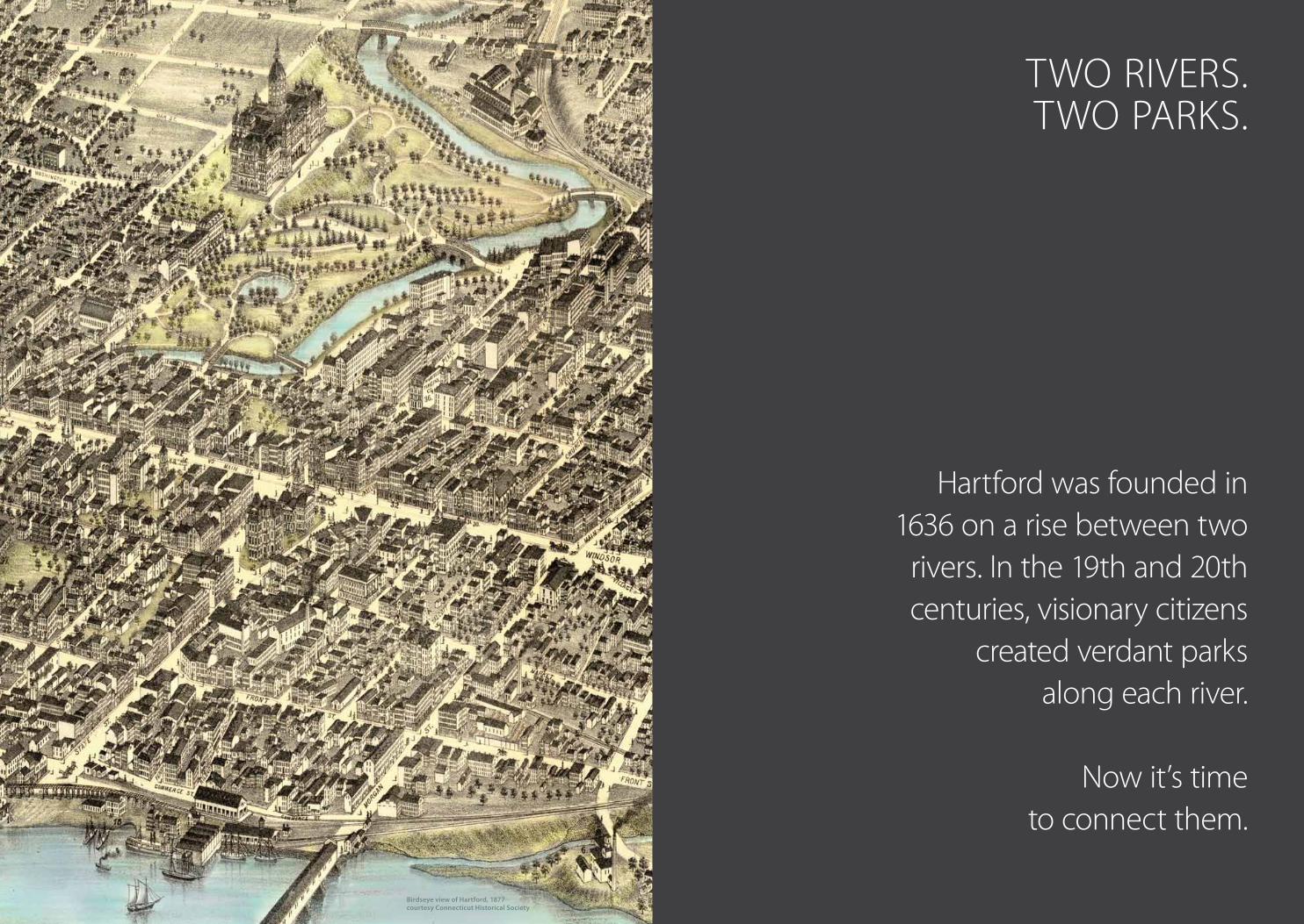
Hartford was founded in 1636 on a rise between two
rivers . In the 19th and 20th centuries, visionary citizens
created verdant parks along each river .
Now it’s time to connect them .
TWO RIVERS .TWO PARKS .
Birdseye view of Hartford, 1877courtesy Connecticut Historical Society
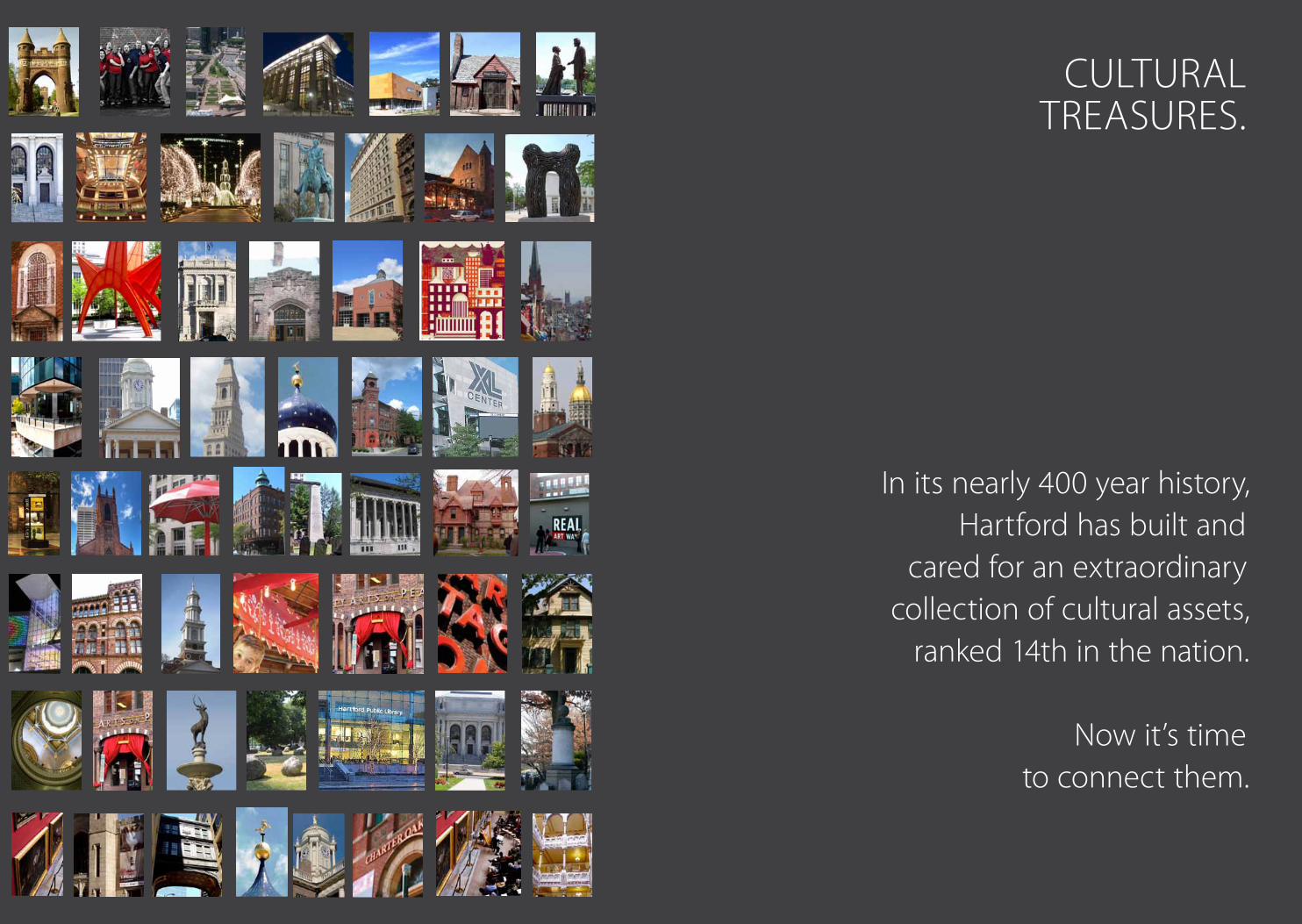
CULTURALTREASURES .
In its nearly 400 year history, Hartford has built and
cared for an extraordinary collection of cultural assets,
ranked 14th in the nation .
Now it’s time to connect them .
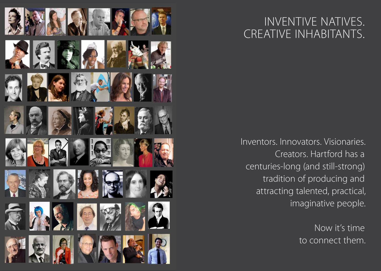
INVENTIVE NATIVES .CREATIVE INHAbITANTS .
Inventors . Innovators . Visionaries . Creators . Hartford has a
centuries-long (and still-strong) tradition of producing and
attracting talented, practical, imaginative people .
Now it’s time to connect them .
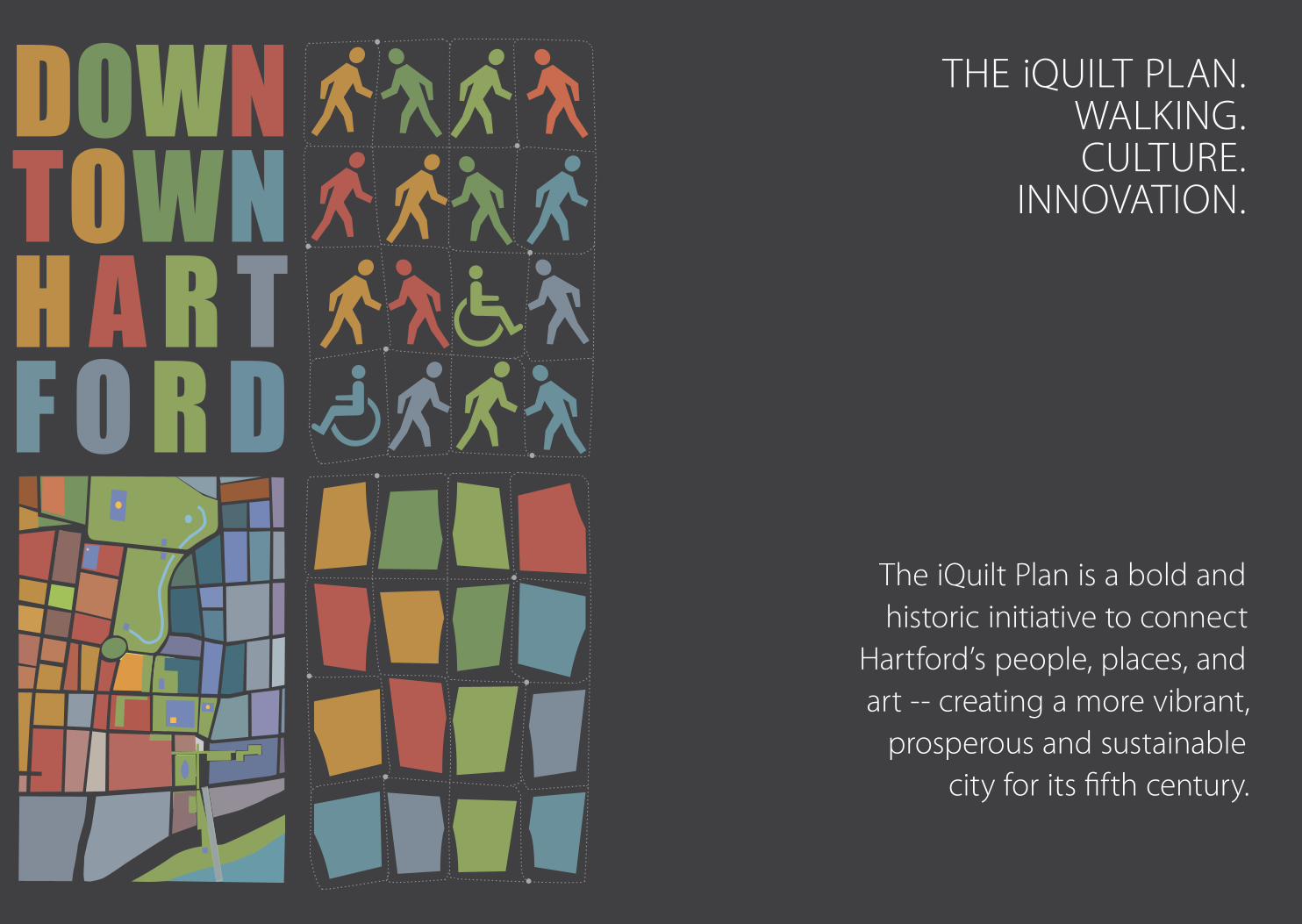
The iQuilt Plan is a bold and historic initiative to connect
Hartford’s people, places, and art -- creating a more vibrant,
prosperous and sustainable city for its fifth century .
THE iQUILT PLAN .WALKING .CULTURE .
INNOVATION .
16 17iQUILT OVERVIEW
PR
EFA
CE
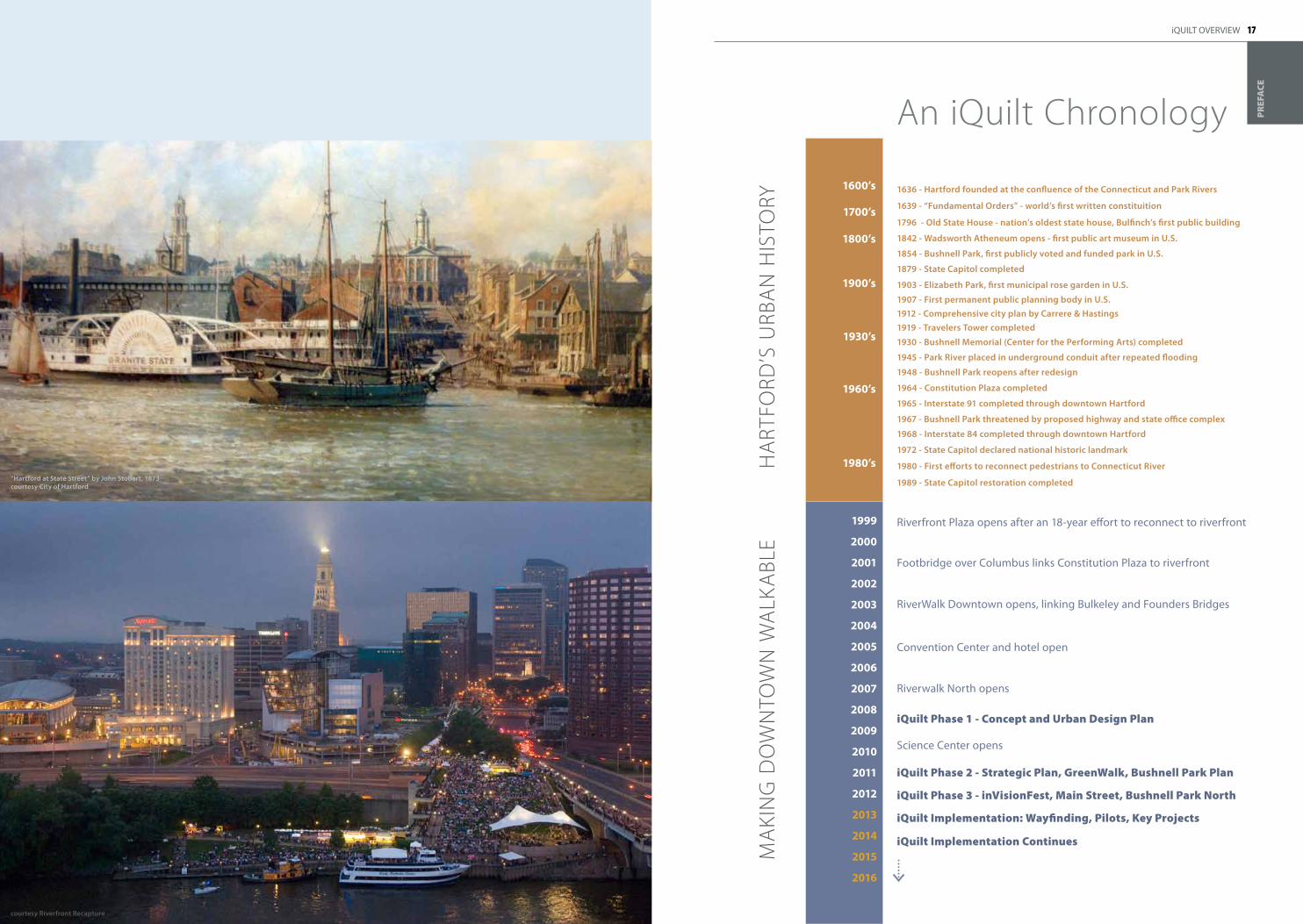
An iQuilt Chronology
Footbridge over Columbus links Constitution Plaza to riverfront
RiverWalk Downtown opens, linking Bulkeley and Founders Bridges
Convention Center and hotel open
Riverwalk North opens
iQuilt Phase 1 - Concept and Urban Design Plan
Science Center opens
iQuilt Phase 2 - Strategic Plan, GreenWalk, Bushnell Park Plan
iQuilt Phase 3 - inVisionFest, Main Street, Bushnell Park North
iQuilt Implementation: Wayfinding, Pilots, Key Projects
iQuilt Implementation Continues
Riverfront Plaza opens after an 18-year effort to reconnect to riverfront
1636 - Hartford founded at the confluence of the Connecticut and Park Rivers
1639 - “Fundamental orders” - world’s first written constituition
1842 - Wadsworth Atheneum opens - first public art museum in U.S.
1903 - Elizabeth Park, first municipal rose garden in U.S.
1796 - old State House - nation’s oldest state house, Bulfinch’s first public building
1854 - Bushnell Park, first publicly voted and funded park in U.S.
1879 - State Capitol completed
1907 - First permanent public planning body in U.S.1912 - Comprehensive city plan by Carrere & Hastings1919 - travelers tower completed
1930 - Bushnell Memorial (Center for the Performing Arts) completed
1964 - Constitution Plaza completed
1968 - Interstate 84 completed through downtown Hartford
1967 - Bushnell Park threatened by proposed highway and state office complex
1989 - State Capitol restoration completed
1972 - State Capitol declared national historic landmark
1980 - First efforts to reconnect pedestrians to Connecticut River
1965 - Interstate 91 completed through downtown Hartford
1945 - Park River placed in underground conduit after repeated flooding
1948 - Bushnell Park reopens after redesign
1999
2000
2001
2002
2003
2004
2005
2006
2007
2008
2009
2010
2011
2012
2013
2014
2015
2016
1600’s
1700’s
1800’s
1900’s
1930’s
1980’s
1960’s
HA
RTfO
RD’S
URb
AN
HIS
TORy
MA
KIN
G D
OW
NTO
WN
WA
LKA
bLE
courtesy Riverfront Recapture
“Hartford at State Street” by john Stobart, 1873courtesy City of Hartford
18 19
N
iQUILT OVERVIEW
PR
EFA
CE
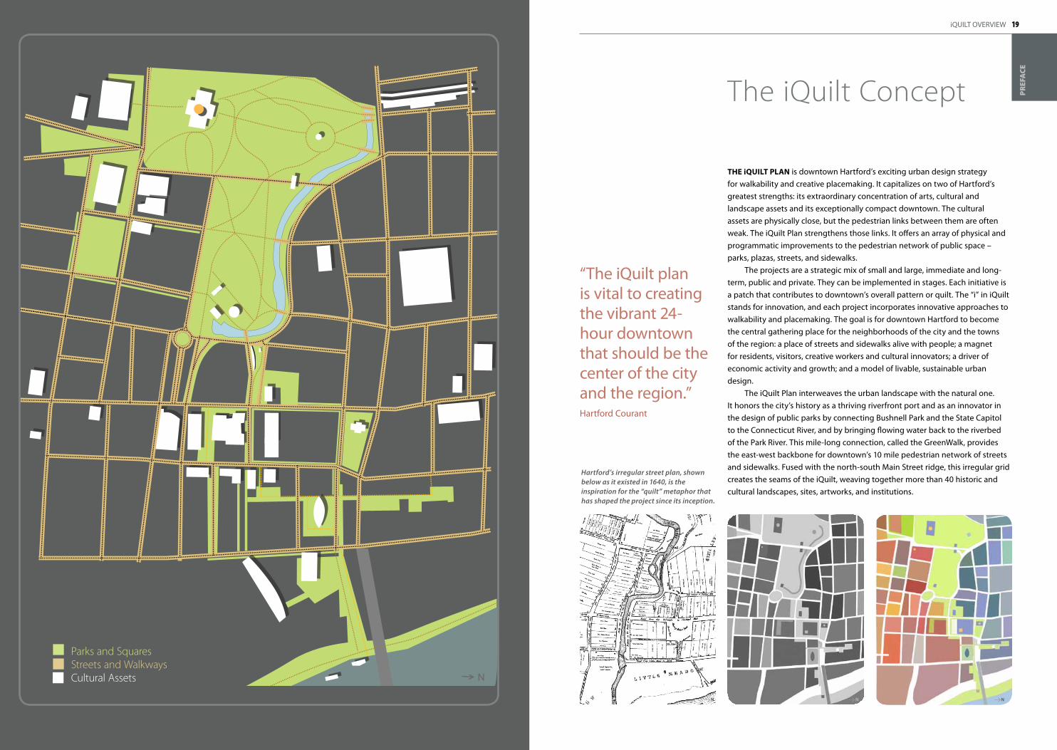
The iQuilT plaN is downtown Hartford’s exciting urban design strategy for walkability and creative placemaking. It capitalizes on two of Hartford’s greatest strengths: its extraordinary concentration of arts, cultural and landscape assets and its exceptionally compact downtown. The cultural assets are physically close, but the pedestrian links between them are often weak. The iQuilt Plan strengthens those links. It offers an array of physical and programmatic improvements to the pedestrian network of public space – parks, plazas, streets, and sidewalks.
The projects are a strategic mix of small and large, immediate and long-term, public and private. They can be implemented in stages. Each initiative is a patch that contributes to downtown’s overall pattern or quilt. The “i” in iQuilt stands for innovation, and each project incorporates innovative approaches to walkability and placemaking. The goal is for downtown Hartford to become the central gathering place for the neighborhoods of the city and the towns of the region: a place of streets and sidewalks alive with people; a magnet for residents, visitors, creative workers and cultural innovators; a driver of economic activity and growth; and a model of livable, sustainable urban design.
The iQuilt Plan interweaves the urban landscape with the natural one. It honors the city’s history as a thriving riverfront port and as an innovator in the design of public parks by connecting Bushnell Park and the State Capitol to the Connecticut River, and by bringing flowing water back to the riverbed of the Park River. This mile-long connection, called the GreenWalk, provides the east-west backbone for downtown’s 10 mile pedestrian network of streets and sidewalks. Fused with the north-south Main Street ridge, this irregular grid creates the seams of the iQuilt, weaving together more than 40 historic and cultural landscapes, sites, artworks, and institutions.
Hartford’s irregular street plan, shown below as it existed in 1640, is the inspiration for the “quilt” metaphor that has shaped the project since its inception.
“The iQuilt plan is vital to creating the vibrant 24-hour downtown that should be the center of the city and the region.”Hartford Courant
The iQuilt Concept
Parks and SquaresStreets and WalkwaysCultural Assets
NN N
20 21iQUILT OVERVIEW
PR
EFA
CE
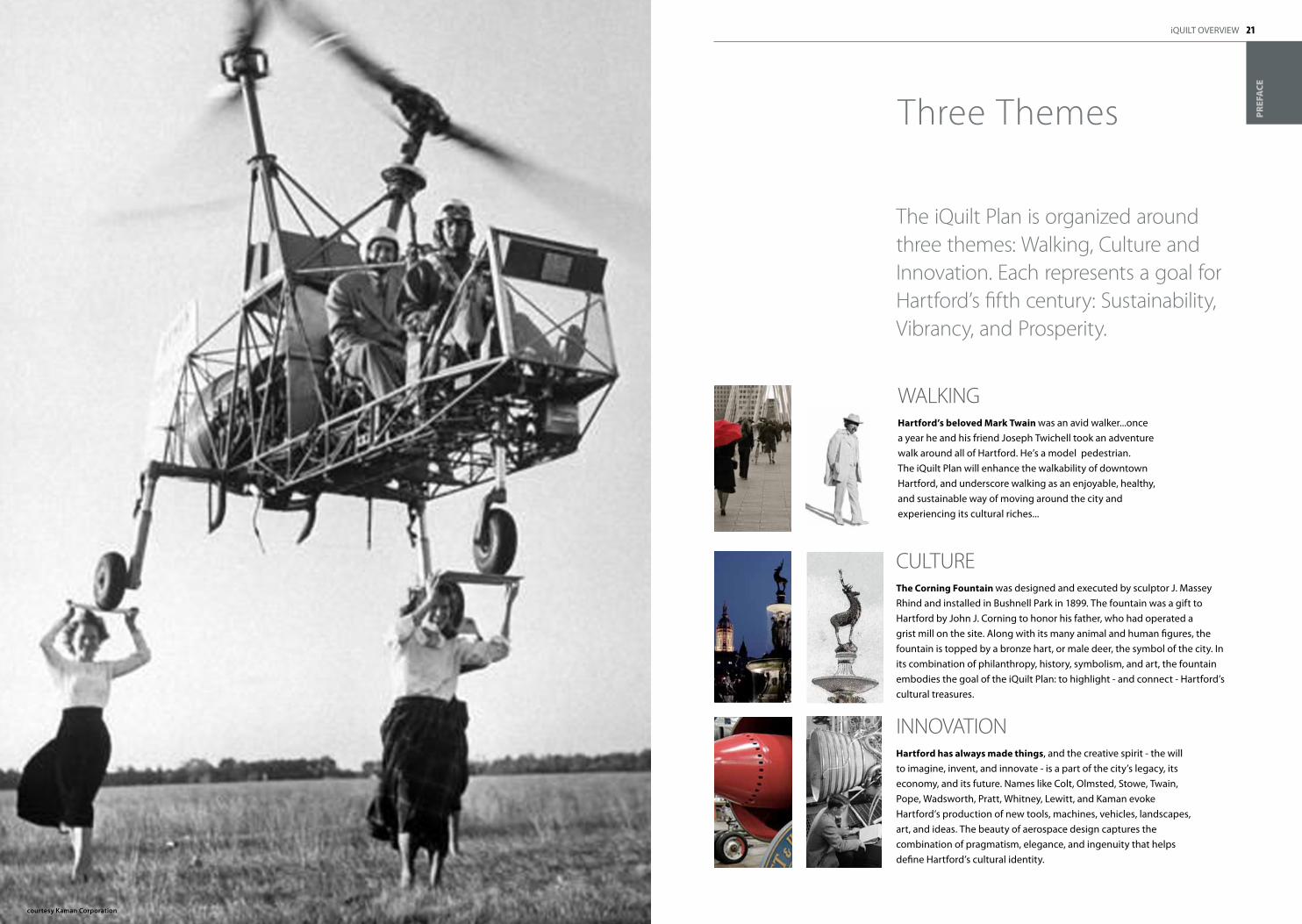
WALKINGhartford’s beloved Mark Twain was an avid walker...once a year he and his friend Joseph Twichell took an adventure walk around all of Hartford. He’s a model pedestrian. The iQuilt Plan will enhance the walkability of downtown Hartford, and underscore walking as an enjoyable, healthy, and sustainable way of moving around the city and experiencing its cultural riches...
CULTUREThe Corning Fountain was designed and executed by sculptor J. Massey Rhind and installed in Bushnell Park in 1899. The fountain was a gift to Hartford by John J. Corning to honor his father, who had operated a grist mill on the site. Along with its many animal and human figures, the fountain is topped by a bronze hart, or male deer, the symbol of the city. In its combination of philanthropy, history, symbolism, and art, the fountain embodies the goal of the iQuilt Plan: to highlight - and connect - Hartford’s cultural treasures.
INNOVATIONhartford has always made things, and the creative spirit - the will to imagine, invent, and innovate - is a part of the city’s legacy, its economy, and its future. Names like Colt, Olmsted, Stowe, Twain, Pope, Wadsworth, Pratt, Whitney, Lewitt, and Kaman evoke Hartford’s production of new tools, machines, vehicles, landscapes, art, and ideas. The beauty of aerospace design captures the combination of pragmatism, elegance, and ingenuity that helps define Hartford’s cultural identity.
The iQuilt Plan is organized around three themes: Walking, Culture and Innovation . Each represents a goal for Hartford’s fifth century: Sustainability, Vibrancy, and Prosperity .
Three Themes
courtesy kaman Corporation
22 23
RECOGNITIONThe iQuilt Plan has received broad recognition in the city, the state, and the nation. Rocco Landesman, Chairman of the National Endowment for the Arts, has called it one of the best plans in the country -- the Endowment has given Hartford major grants two years running. The plan’s design also received a major award from the American Institute of Architects.
Nea Cultural placemaking Grant 2010Nea Cultural placemaking Grant 2011aia honor award in urban Design 2010
courtesy Greater Hartford Arts Council
American Institute ofArchitects
iQUILT OVERVIEW
PR
EFA
CE
“I’m a true believer - the iQuilt will economically and culturally strengthen our capital city.”Congressman John Larson
HARTFORD’S ARTS ECONOMY:
$244 million in local economic activity
$436 million in total impact
$18 million in state revenue
1.25 million attendees
7,300 jobs
source: Greater Hartford Arts Council, 2008
An improved pedestrian network will encourage more walking, reduce vehicular trips and emissions, improve the liveliness of downtown’s sidewalk and public spaces, provide more foot traffic and customers for local shops, restaurants, cafes and cultural venues, and create an urban energy and quality of life that can attract talented workers to the city and region.
Across the country, initial investments in public space have paid off with multifold private investment in adjacent property, in the form of new housing, workplaces, shops, and restaurants (see Section 3 • Implementation)
Busy sidewalks can also improve public safety – both actual and perceived. Lively public environments, and a habit of gathering downtown, creates an irreplaceable sense of community and civic possibility that is the hallmark of most successful cities.
An improved walking and biking network contributes to public health both directly, through increased exercise, and indirectly, by conveying a message about healthy urban lifestyles. The network is a physical embodiment of the message that Hartford’s health insurance and life insurance companies are already conveying to their customers: exercise reduces disease and extends life.
The linking of cultural institutions can not only increase visitors and attendance, but can create – indeed, in the iQuilt planning process, has already begun to create – a mutual support network including cross-promotion and cross-programming.
Hartford’s arts economy is already a powerhouse. The strengthening of Hartford’s position as an arts and culture magnet can be used to attract even more visitors to the city and region, from individuals to conventions. The enduring qualities of cultural achievement – great parks, art collections, performance, thriving public space – reinforce the city’s identity and sense of place.
The focus on innovation is a constant reminder that Hartford, even with its cultural strengths, cannot live off of its proud past, but must renew and extend its tradition of ingenuity and invention. Innovation must be a practice as well as a byword, as the city seeks to re-establish strong economic foundations for its fifth century.
The iQuilt Plan’s combined focus on walking, culture, and innovation can have significant environmental, social, and economic benefits .
Potential benefits
OUTREACHSince its earliest days in 2008, the iQuilt Plan has engaged the public in the process of developing its themes, concepts, designs, and strategies. This has included more than 14 public presentations and workshops and more than 80 briefings for more than two thousand public officials, stakeholder groups, and private citizens. A website launched in April 2011 has attracted more than 4,600 individual viewers and 18,000 page views. In the new governance structure of the iQuilt Partnership, a 501c3 non-profit organization, a Board of Corporators will include as many as 75 members of the public in the project’s oversight.
ACCEPTANCEThe iQuilt concept, originally developed by the Bushnell Center for the Performing Arts, with the support of the Greater Hartford Arts Council, was officially adopted by the Hartford City Council in 2010 as a key component of “One City, One Plan”, the city’s ten-year blueprint for conservation and development. Under the day-to-day management of the Metro Hartford Alliance, the iQuilt Partnership now represents a comprehensive coalition of Hartford’s public, private, non-profit, and community organizations.
1The iQuilt Strategic Plan
“One of the best plans in the country...this project is really going to transform downtown Hartford.”
Rocco LandesmanChairman National Endowment for the Arts
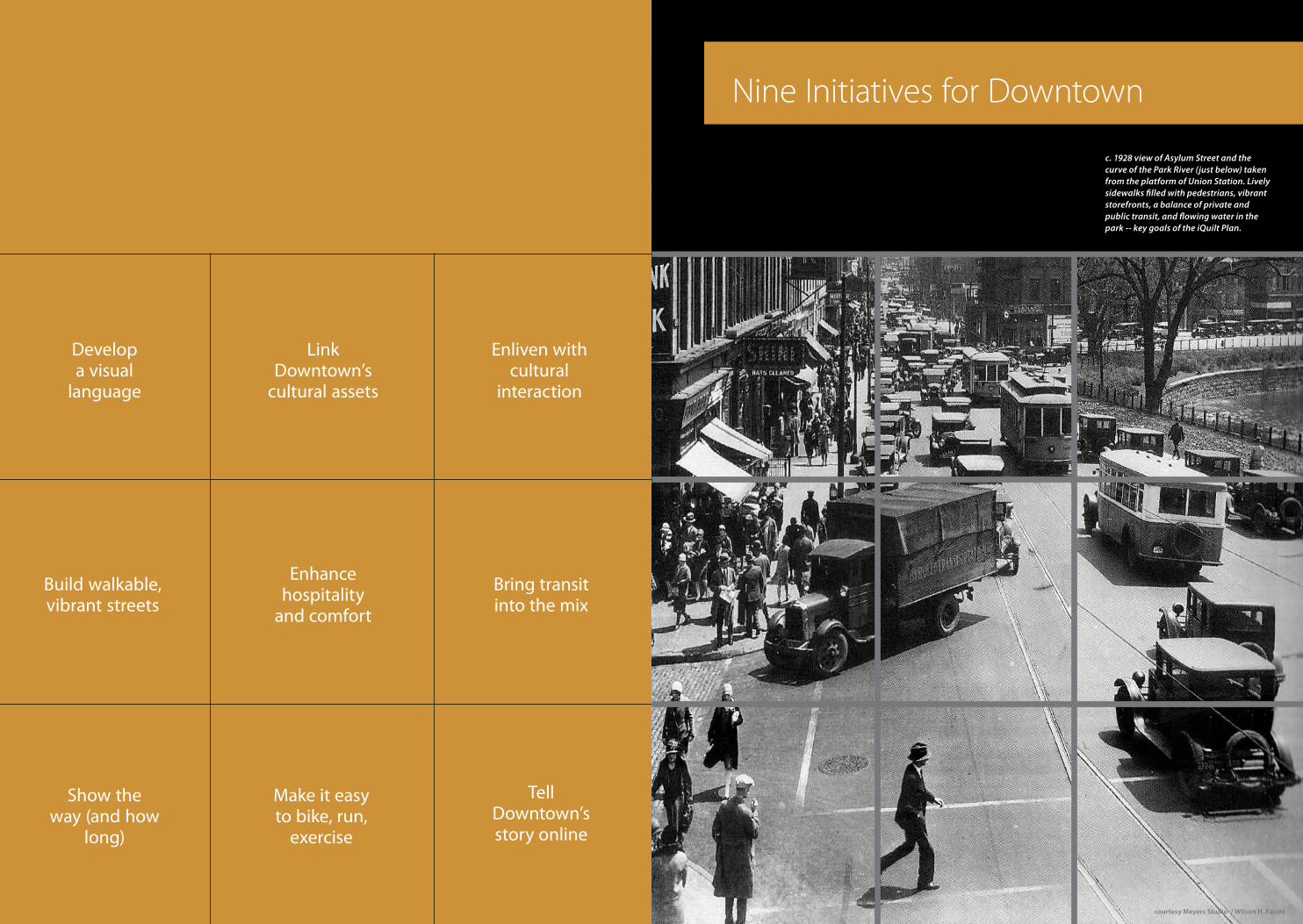
Nine Initiatives for Downtown
c. 1928 view of Asylum Street and the curve of the Park River (just below) taken from the platform of Union Station. Lively sidewalks filled with pedestrians, vibrant storefronts, a balance of private and public transit, and flowing water in the park -- key goals of the iQuilt Plan.
Bring transit into the mix
Build walkable, vibrant streets
Link Downtown’s
cultural assets
Develop a visual
language
Show the way (and how
long)
Enhance hospitality
and comfort
Make it easy to bike, run,
exercise
Tell Downtown’s story online
Enliven with cultural
interaction
courtesy Meyers Studio / Wilson H. Faude
28 29iQUILT OVERVIEW
DO
WN
TOW
N
Founders BridgeRiverfront Plaza
Constitution Plaza
Convention Center
Science CenterOld State House
WadsworthBushnell
Memorial ArchCapitol
Union Station
4
1
2
5
5
10
16
14
16
16
5
3
6
6
11
17
15
17
17
3
2
5
7
14
11
13
13
4
3
8
15
13
15
15
6
4
12
9
10
11
5
15
12
15
18
10
8
10
13
4
2
9
4
5 7
Foun
ders
Brid
ge
Rive
rfron
t Pla
za
Cons
titut
ion
Plaz
a
Scie
nce
Cent
er
Old
Stat
e Ho
use
Conv
entio
n Ct
r.
Wad
swor
th
Bush
nell
Mem
oria
l Arc
h
Capi
tol
Unio
n St
atio
n
Before
After
11
13
10
9
5
11
151715
N
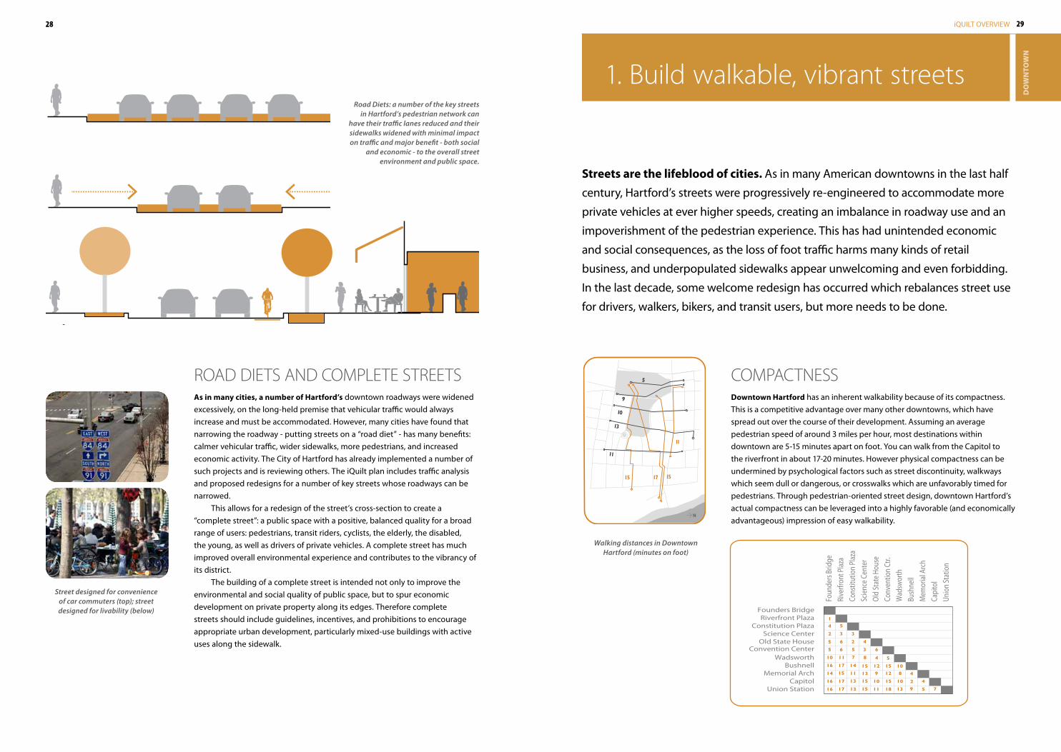
1 . build walkable, vibrant streets
COMPACTNESSDowntown hartford has an inherent walkability because of its compactness. This is a competitive advantage over many other downtowns, which have spread out over the course of their development. Assuming an average pedestrian speed of around 3 miles per hour, most destinations within downtown are 5-15 minutes apart on foot. You can walk from the Capitol to the riverfront in about 17-20 minutes. However physical compactness can be undermined by psychological factors such as street discontinuity, walkways which seem dull or dangerous, or crosswalks which are unfavorably timed for pedestrians. Through pedestrian-oriented street design, downtown Hartford’s actual compactness can be leveraged into a highly favorable (and economically advantageous) impression of easy walkability.
Streets are the lifeblood of cities. As in many American downtowns in the last half
century, Hartford’s streets were progressively re-engineered to accommodate more
private vehicles at ever higher speeds, creating an imbalance in roadway use and an
impoverishment of the pedestrian experience. This has had unintended economic
and social consequences, as the loss of foot traffic harms many kinds of retail
business, and underpopulated sidewalks appear unwelcoming and even forbidding.
In the last decade, some welcome redesign has occurred which rebalances street use
for drivers, walkers, bikers, and transit users, but more needs to be done.
ROAD DIETS AND COMPLETE STREETSas in many cities, a number of hartford’s downtown roadways were widened excessively, on the long-held premise that vehicular traffic would always increase and must be accommodated. However, many cities have found that narrowing the roadway - putting streets on a “road diet” - has many benefits: calmer vehicular traffic, wider sidewalks, more pedestrians, and increased economic activity. The City of Hartford has already implemented a number of such projects and is reviewing others. The iQuilt plan includes traffic analysis and proposed redesigns for a number of key streets whose roadways can be narrowed.
This allows for a redesign of the street’s cross-section to create a “complete street”: a public space with a positive, balanced quality for a broad range of users: pedestrians, transit riders, cyclists, the elderly, the disabled, the young, as well as drivers of private vehicles. A complete street has much improved overall environmental experience and contributes to the vibrancy of its district.
The building of a complete street is intended not only to improve the environmental and social quality of public space, but to spur economic development on private property along its edges. Therefore complete streets should include guidelines, incentives, and prohibitions to encourage appropriate urban development, particularly mixed-use buildings with active uses along the sidewalk.
Road Diets: a number of the key streets in Hartford’s pedestrian network can
have their traffic lanes reduced and their sidewalks widened with minimal impact on traffic and major benefit - both social
and economic - to the overall street environment and public space.
Walking distances in Downtown Hartford (minutes on foot)
Street designed for convenience of car commuters (top); street designed for livability (below)
30 31iQUILT OVERVIEW
DO
WN
TOW
N
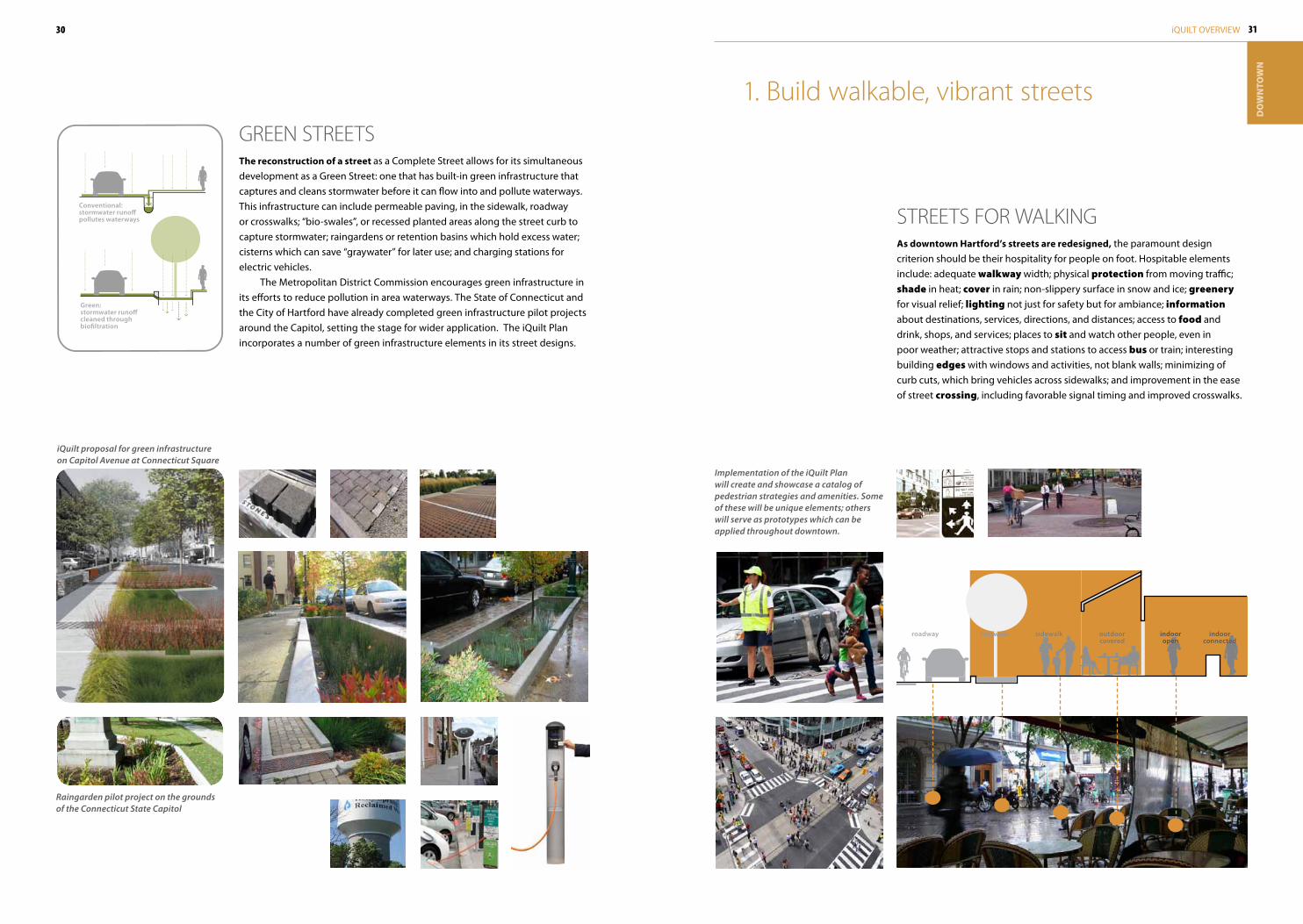
STREETS fOR WALKINGas downtown hartford’s streets are redesigned, the paramount design criterion should be their hospitality for people on foot. Hospitable elements include: adequate walkway width; physical protection from moving traffic; shade in heat; cover in rain; non-slippery surface in snow and ice; greenery for visual relief; lighting not just for safety but for ambiance; information about destinations, services, directions, and distances; access to food and drink, shops, and services; places to sit and watch other people, even in poor weather; attractive stops and stations to access bus or train; interesting building edges with windows and activities, not blank walls; minimizing of curb cuts, which bring vehicles across sidewalks; and improvement in the ease of street crossing, including favorable signal timing and improved crosswalks.
1 . build walkable, vibrant streets
Implementation of the iQuilt Plan will create and showcase a catalog of pedestrian strategies and amenities. Some of these will be unique elements; others will serve as prototypes which can be applied throughout downtown.
roadway bioswale sidewalk outdoorcovered
indooropen
indoorconnected
GREEN STREETSThe reconstruction of a street as a Complete Street allows for its simultaneous development as a Green Street: one that has built-in green infrastructure that captures and cleans stormwater before it can flow into and pollute waterways. This infrastructure can include permeable paving, in the sidewalk, roadway or crosswalks; “bio-swales”, or recessed planted areas along the street curb to capture stormwater; raingardens or retention basins which hold excess water; cisterns which can save “graywater” for later use; and charging stations for electric vehicles.
The Metropolitan District Commission encourages green infrastructure in its efforts to reduce pollution in area waterways. The State of Connecticut and the City of Hartford have already completed green infrastructure pilot projects around the Capitol, setting the stage for wider application. The iQuilt Plan incorporates a number of green infrastructure elements in its street designs.
Raingarden pilot project on the grounds of the Connecticut State Capitol
iQuilt proposal for green infrastructure on Capitol Avenue at Connecticut Square
Conventional: stormwater runoff pollutes waterways
Green:stormwater runoff cleaned through biofiltration
32 33iQUILT OVERVIEW
DO
WN
TOW
N
HartfordArt School
HandelCenter
ArtistCollective
Proposed
Twain/Stowe
RealArtways
BillingsForge
Academyof the Arts
ParkStreet
CineStudio
Coltsville
HarttSchool
Downtown
N
THE STREETS AND THE GREENWALKlinking Downtown’s cultural assets is best accomplished through a readily understandable network of streets, squares, and walkways. Wayfinding infrastructure will help overcome visual barriers and show the way - for example, helping to understand the somewhat confusing pattern of street names (Asylum becomes State, Pearl becomes Central Row, Wells becomes Arch), and showing through routes on streets which terminate at a building (Allyn, Church, Pratt, Lewis among others). Pedestrian amenities will make the walking comfortable and enjoyable. And the GreenWalk will provide a large-scale framework to encourage connections between assets which might otherwise seem too far apart.
2 . Link Downtown’s cultural assets
A CITyWIDE CULTURAL NETWORKThough downtown hartford enjoys a concentration of cultural assets, Hartford’s cultural activity extends well beyond the boundaries of the iQuilt. A key goal of the iQuilt Plan is to develop a city-wide cultural network that works in both directions: extending downtown venues into the neighborhoods, and providing neighborhood-based institutions with a foothold and showcase downtown. The linking of cultural institutions, which has already begun informally as part of the iQuilt planning process, can increase cross-promotion and cross-programming.
“North is to the right”Though many maps of Hartford are oriented with north up, the maps used in this document are generally oriented with north to the right, unless otherwise indicated. This puts the Capitol at the top and the river at the bottom, reflecting Hartford’s origins as a river port and its role as Connecticut’s capital city.
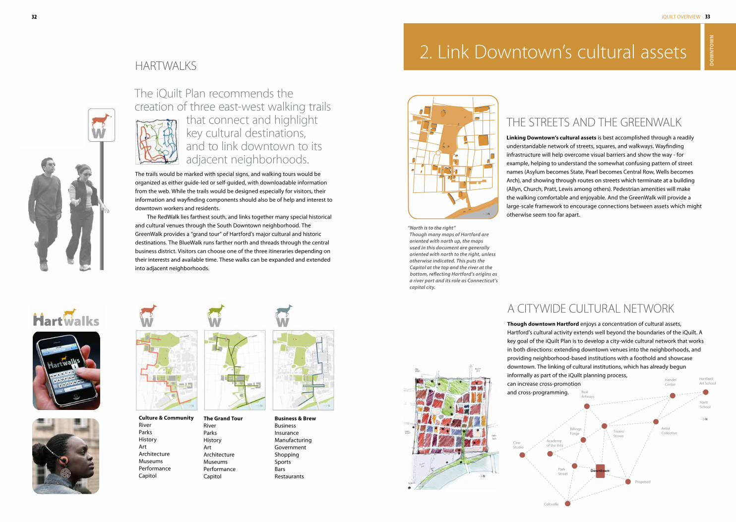
HARTWALKS
Business & BrewBusinessInsuranceManufacturingGovernmentShoppingSportsBarsRestaurants
Culture & CommunityRiverParksHistoryArtArchitectureMuseumsPerformanceCapitol
The trails would be marked with special signs, and walking tours would be organized as either guide-led or self-guided, with downloadable information from the web. While the trails would be designed especially for visitors, their information and wayfinding components should also be of help and interest to downtown workers and residents.
The RedWalk lies farthest south, and links together many special historical and cultural venues through the South Downtown neighborhood. The GreenWalk provides a “grand tour” of Hartford’s major cultural and historic destinations. The BlueWalk runs farther north and threads through the central business district. Visitors can choose one of the three itineraries depending on their interests and available time. These walks can be expanded and extended into adjacent neighborhoods.
The Grand TourRiverParksHistoryArtArchitectureMuseumsPerformanceCapitol
The iQuilt Plan recommends the creation of three east-west walking trails
that connect and highlight key cultural destinations, and to link downtown to its adjacent neighborhoods .
N
N
N N N
34 35iQUILT OVERVIEW
DO
WN
TOW
N
Public Library 1 min.
Old State House 6 mins.
Bushnell Park Library 4 mins.
INFoRMAtIoN • INNoVAtIoN
HIStoRY • CULtURE
WAYFINDING
HoSPItALItY • CoMFoRt
WALkING • BIkING
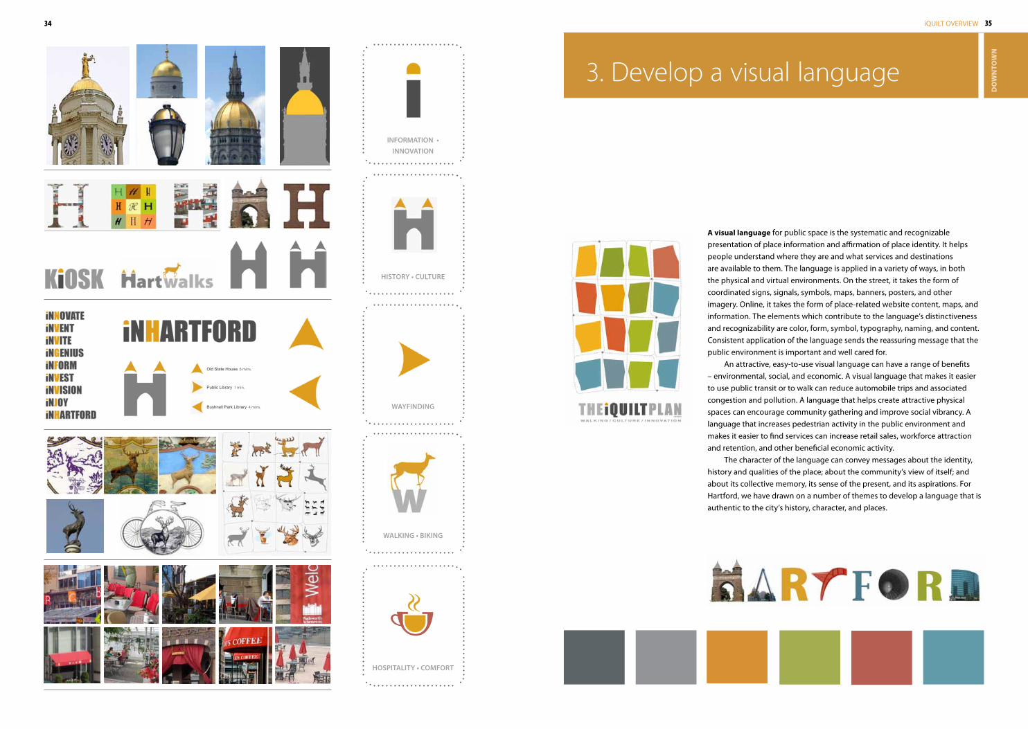
a visual language for public space is the systematic and recognizable presentation of place information and affirmation of place identity. It helps people understand where they are and what services and destinations are available to them. The language is applied in a variety of ways, in both the physical and virtual environments. On the street, it takes the form of coordinated signs, signals, symbols, maps, banners, posters, and other imagery. Online, it takes the form of place-related website content, maps, and information. The elements which contribute to the language’s distinctiveness and recognizability are color, form, symbol, typography, naming, and content. Consistent application of the language sends the reassuring message that the public environment is important and well cared for.
An attractive, easy-to-use visual language can have a range of benefits – environmental, social, and economic. A visual language that makes it easier to use public transit or to walk can reduce automobile trips and associated congestion and pollution. A language that helps create attractive physical spaces can encourage community gathering and improve social vibrancy. A language that increases pedestrian activity in the public environment and makes it easier to find services can increase retail sales, workforce attraction and retention, and other beneficial economic activity.
The character of the language can convey messages about the identity, history and qualities of the place; about the community’s view of itself; and about its collective memory, its sense of the present, and its aspirations. For Hartford, we have drawn on a number of themes to develop a language that is authentic to the city’s history, character, and places.
3 . Develop a visual language
36 37iQUILT OVERVIEW
DO
WN
TOW
N
PED Head ITERATIONS
00 01 02 03
PED Head ITERATIONS
00 01 02 03
Public Library 1 min.
Old State House 6 mins.
Bushnell Park Library 4 mins.
WALK
PUSHBUTTONFOR
WALK
PUSHBUTTONFOR
Gold Street100 E
D O W N T O W N
300 S
D O W N T O W N
Main Street
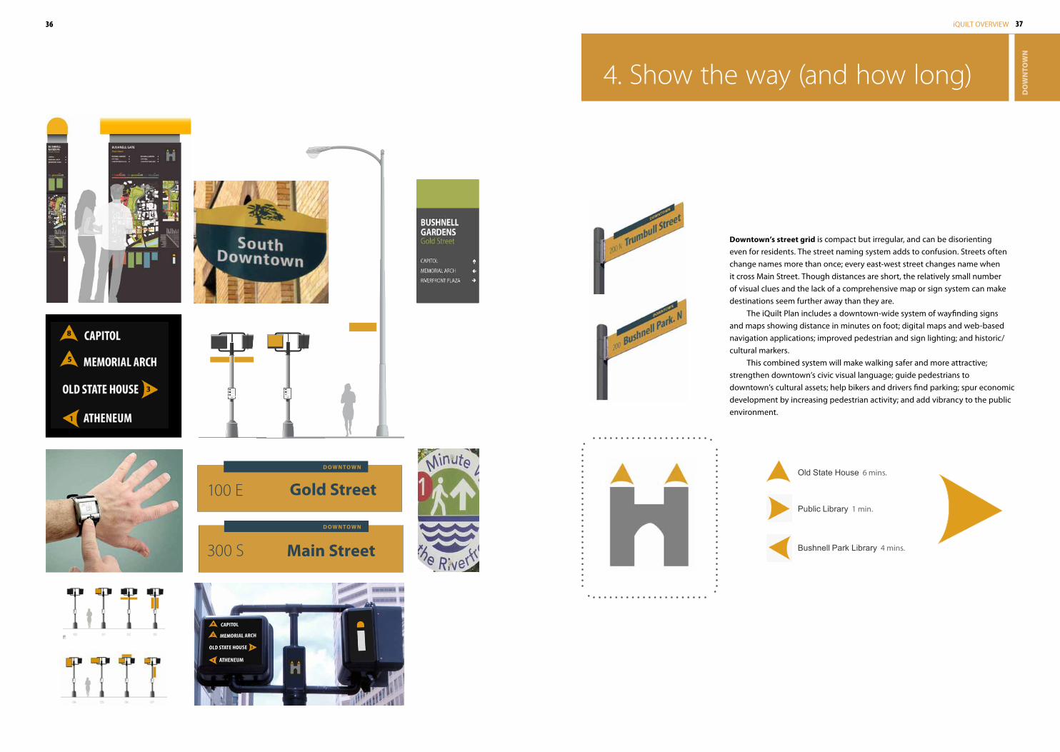
4 . Show the way (and how long)
Downtown’s street grid is compact but irregular, and can be disorienting even for residents. The street naming system adds to confusion. Streets often change names more than once; every east-west street changes name when it cross Main Street. Though distances are short, the relatively small number of visual clues and the lack of a comprehensive map or sign system can make destinations seem further away than they are.
The iQuilt Plan includes a downtown-wide system of wayfinding signs and maps showing distance in minutes on foot; digital maps and web-based navigation applications; improved pedestrian and sign lighting; and historic/cultural markers.
This combined system will make walking safer and more attractive; strengthen downtown’s civic visual language; guide pedestrians to downtown’s cultural assets; help bikers and drivers find parking; spur economic development by increasing pedestrian activity; and add vibrancy to the public environment.
38 39iQUILT OVERVIEW
DO
WN
TOW
N
5 . Enliven with cultural interaction
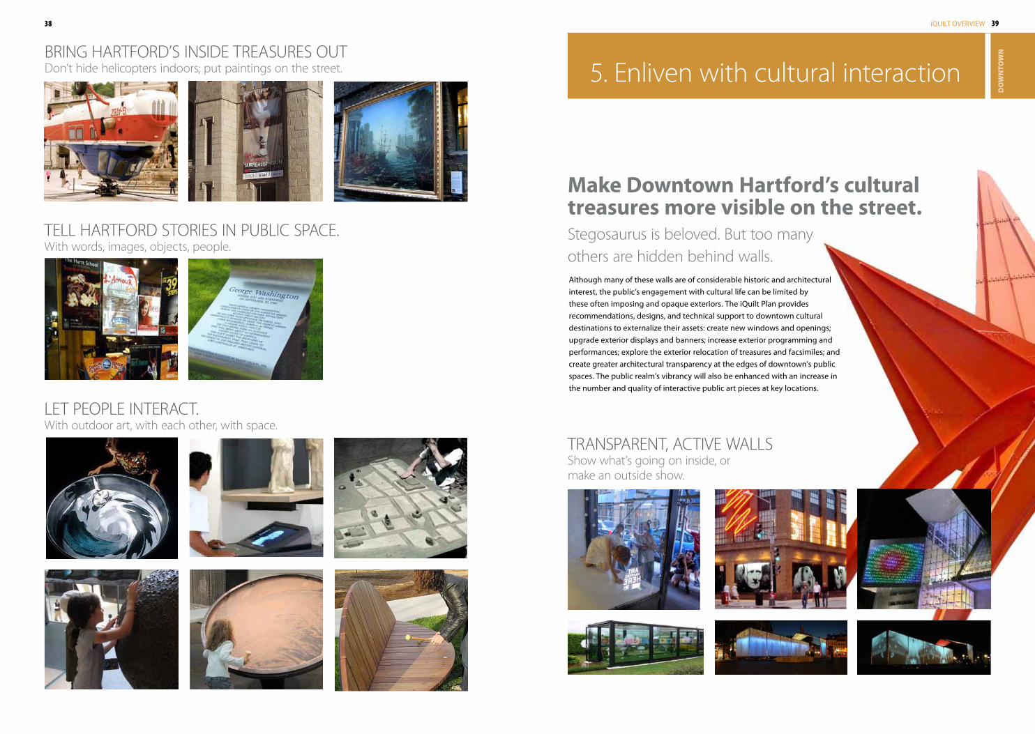
TRANSPARENT, ACTIVE WALLSShow what’s going on inside, or make an outside show .
Stegosaurus is beloved . but too many others are hidden behind walls .
Make Downtown hartford’s cultural treasures more visible on the street.
Although many of these walls are of considerable historic and architectural interest, the public’s engagement with cultural life can be limited by these often imposing and opaque exteriors. The iQuilt Plan provides recommendations, designs, and technical support to downtown cultural destinations to externalize their assets: create new windows and openings; upgrade exterior displays and banners; increase exterior programming and performances; explore the exterior relocation of treasures and facsimiles; and create greater architectural transparency at the edges of downtown’s public spaces. The public realm’s vibrancy will also be enhanced with an increase in the number and quality of interactive public art pieces at key locations.
TELL HARTfORD STORIES IN PUbLIC SPACE .With words, images, objects, people .
LET PEOPLE INTERACT .With outdoor art, with each other, with space .
bRING HARTfORD’S INSIDE TREASURES OUTDon’t hide helicopters indoors; put paintings on the street .
40 41iQUILT OVERVIEW
DO
WN
TOW
N
courtesy Hartford Denim Company
6 . Enhance hospitality and comfort
COMfORTING iQUILT CAfé bLANKETS
MOVEAbLE CAfé CHAIRS
HOSPITAbLE HANDOUT UMbRELLAS
HELPfUL GREETERS, USEfUL INfORMATION
APPAREL fOR THE GREENWALK
42 43iQUILT OVERVIEW
DO
WN
TOW
N
Before
After
P
Downtown Hartford
Maine
Downtown Hartford
Florida
.357 .45
9.5010
.5511
.5511
.6513
.6513
.7014
.7515
7 . Make it easy to bike, run, exercise
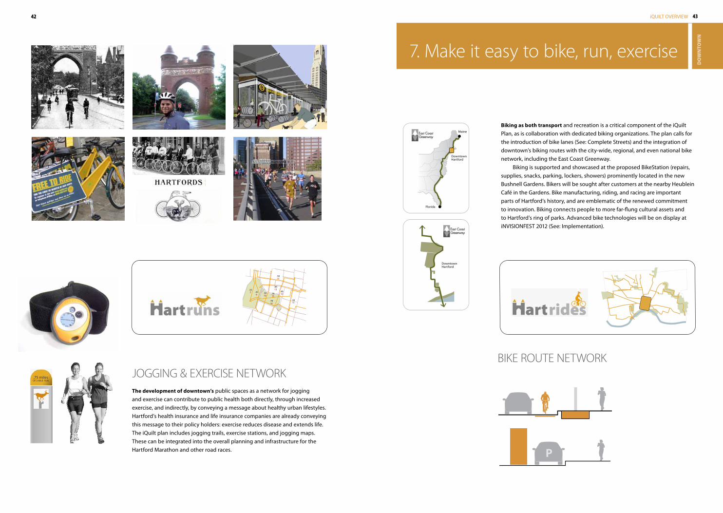
Biking as both transport and recreation is a critical component of the iQuilt Plan, as is collaboration with dedicated biking organizations. The plan calls for the introduction of bike lanes (See: Complete Streets) and the integration of downtown’s biking routes with the city-wide, regional, and even national bike network, including the East Coast Greenway.
Biking is supported and showcased at the proposed BikeStation (repairs, supplies, snacks, parking, lockers, showers) prominently located in the new Bushnell Gardens. Bikers will be sought after customers at the nearby Heublein Café in the Gardens. Bike manufacturing, riding, and racing are important parts of Hartford’s history, and are emblematic of the renewed commitment to innovation. Biking connects people to more far-flung cultural assets and to Hartford’s ring of parks. Advanced bike technologies will be on display at iNVISIONFEST 2012 (See: Implementation).
bIKE ROUTE NETWORK.75 milesOF 3 MILE RUN
The development of downtown’s public spaces as a network for jogging and exercise can contribute to public health both directly, through increased exercise, and indirectly, by conveying a message about healthy urban lifestyles. Hartford’s health insurance and life insurance companies are already conveying this message to their policy holders: exercise reduces disease and extends life. The iQuilt plan includes jogging trails, exercise stations, and jogging maps. These can be integrated into the overall planning and infrastructure for the Hartford Marathon and other road races.
JOGGING & ExERCISE NETWORK
44 45iQUILT OVERVIEW
DO
WN
TOW
N
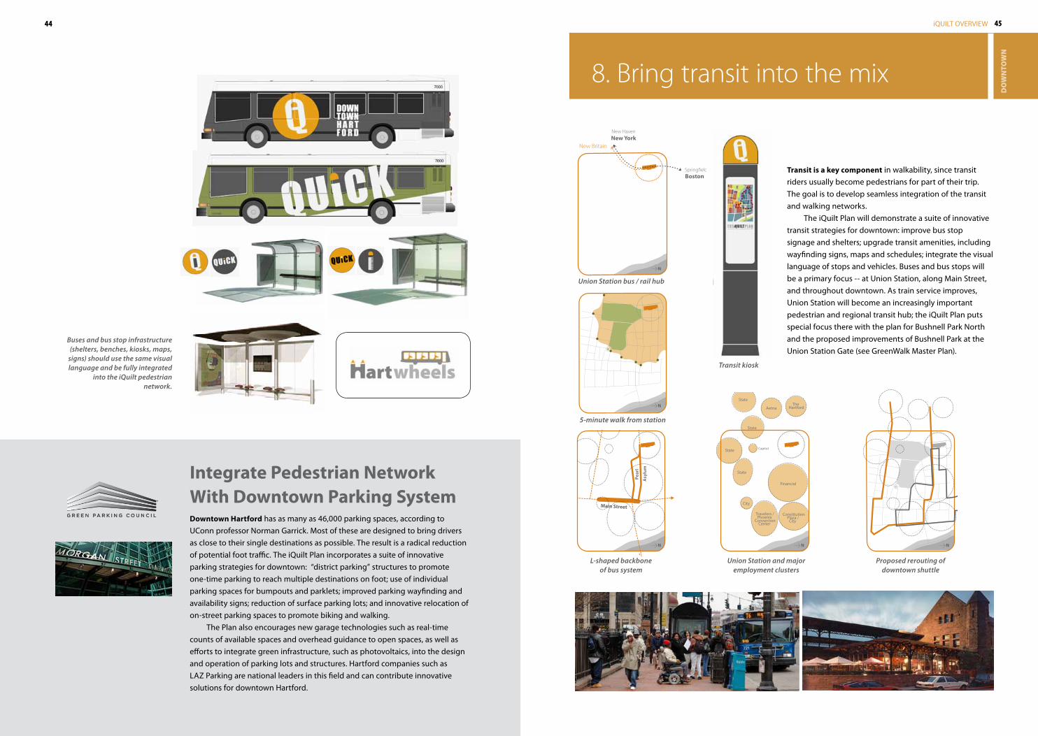
Main Street
Transit is a key component in walkability, since transit riders usually become pedestrians for part of their trip. The goal is to develop seamless integration of the transit and walking networks.
The iQuilt Plan will demonstrate a suite of innovative transit strategies for downtown: improve bus stop signage and shelters; upgrade transit amenities, including wayfinding signs, maps and schedules; integrate the visual language of stops and vehicles. Buses and bus stops will be a primary focus -- at Union Station, along Main Street, and throughout downtown. As train service improves, Union Station will become an increasingly important pedestrian and regional transit hub; the iQuilt Plan puts special focus there with the plan for Bushnell Park North and the proposed improvements of Bushnell Park at the Union Station Gate (see GreenWalk Master Plan).
New HavenNew York
SpringfieldBoston
New Britain
8 . bring transit into the mix
AetnaThe
Hartford
State
State
State
Capitol
City
Travelers /Phoenix
ConventionCenter
ConstitutionPlaza /
City
Financial
State
integrate pedestrian Network With Downtown parking SystemDowntown hartford has as many as 46,000 parking spaces, according to UConn professor Norman Garrick. Most of these are designed to bring drivers as close to their single destinations as possible. The result is a radical reduction of potential foot traffic. The iQuilt Plan incorporates a suite of innovative parking strategies for downtown: “district parking” structures to promote one-time parking to reach multiple destinations on foot; use of individual parking spaces for bumpouts and parklets; improved parking wayfinding and availability signs; reduction of surface parking lots; and innovative relocation of on-street parking spaces to promote biking and walking.
The Plan also encourages new garage technologies such as real-time counts of available spaces and overhead guidance to open spaces, as well as efforts to integrate green infrastructure, such as photovoltaics, into the design and operation of parking lots and structures. Hartford companies such as LAZ Parking are national leaders in this field and can contribute innovative solutions for downtown Hartford.
Union Station bus / rail hub
5-minute walk from station
Buses and bus stop infrastructure (shelters, benches, kiosks, maps,
signs) should use the same visual language and be fully integrated
into the iQuilt pedestrian network.
Transit kiosk
L-shaped backbone of bus system
Union Station and major employment clusters
Proposed rerouting of downtown shuttle
N
N
N N N
Asy
lum
Pear
l
46 47iQUILT OVERVIEW
DO
WN
TOW
N
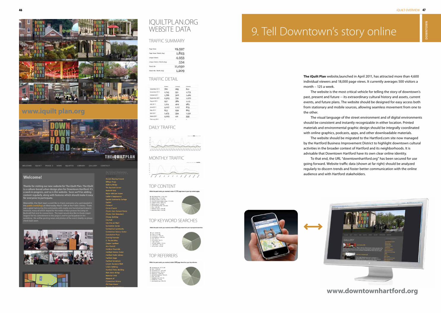
TRAffIC SUMMARy
IQUILTPLAN .ORG WEbSITE DATA
TRAffIC DETAIL
TOP REfERRERS
TOP KEyWORD SEARCHES
TOP CONTENT
DAILy TRAffIC
MONTHLy TRAffIC
9 . Tell Downtown’s story online
The iQuilt plan website,launched in April 2011, has attracted more than 4,600 individual viewers and 18,000 page views. It currently averages 500 visitors a month – 125 a week.
The website is the most critical vehicle for telling the story of downtown’s past, present and future -- its extraordinary cultural history and assets, current events, and future plans. The website should be designed for easy access both from stationary and mobile sources, allowing seamless movement from one to the other.
The visual language of the street environment and of digital environments should be consistent and instantly recognizable in either location. Printed materials and environmental graphic design should be integrally coordinated with online graphics, podcasts, apps, and other downloadable materials.
The website should be migrated to the Hartford.com site now managed by the Hartford Business Improvement District to highlight downtown cultural activities in the broader context of Hartford and its neighborhoods. It is advisable that Downtown Hartford have its own clear online identity.
To that end, the URL “downtownhartford.org” has been secured for use going forward. Website traffic data (shown at far right) should be analyzed regularly to discern trends and foster better communication with the online audience and with Hartford stakeholders.
www.downtownhartford.org
www.iquilt plan.org
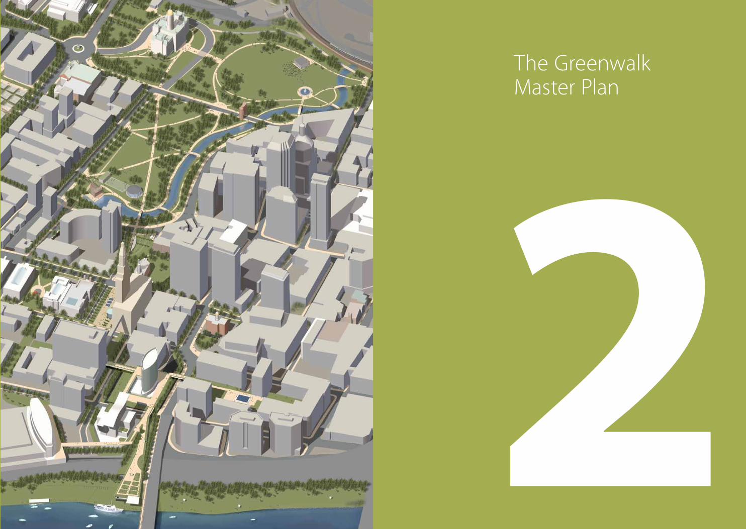
2The Greenwalk Master Plan
50 51iQUILT OVERVIEW
GR
EEN
WA
LK
The iQuilt Plan focuses on strengthening the physical links between downtown Hartford’s cultural assets by enhancing the parks, squares and streets which connect
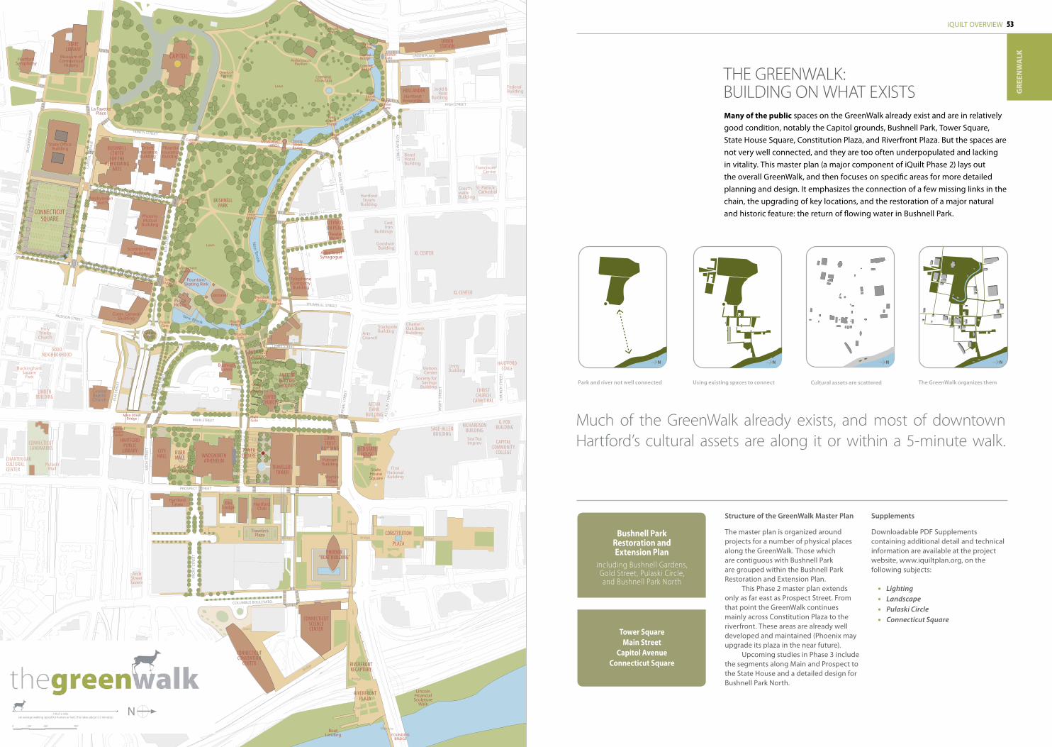
them. The improvement of downtown’s public space is intended to increase foot traffic, cultural vibrancy, and economic activity. The centerpiece of the iQuilt is a chain of green spaces called the GreenWalk.
For pedestrians walking north to south, downtown is fairly well connected - particularly by Main Street and Trumbull Street. But walking in an east-west direction is more challenging. Streets zigzag, terminate, and unexpectedly change names. No major pathway is clearly demarcated on maps or on street signs. For most Hartfordites, a strong east-west axis is not part of their mental map.
As a public space sequence running from west to east, the GreenWalk would provide a strong organizing armature for walking in downtown. It would create a powerful link between downtown’s two great landscapes: Bushnell Park and the Connecticut River waterfront. And it would help connect downtown’s cultural assets, which lie directly along the GreenWalk or within a five-minute walk. The GreenWalk would provide an easy-to-understand, walkable, and enjoyable framework for cultural vitality and economic development.
NS
W
E
INSPIRATION fOR THE GREENWALK
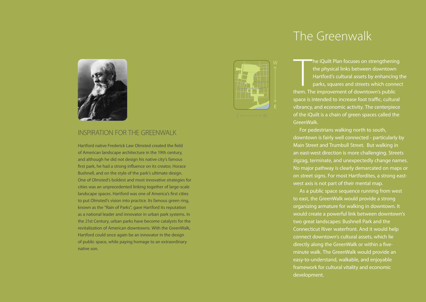
Hartford native Frederick Law Olmsted created the field of American landscape architecture in the 19th century, and although he did not design his native city’s famous first park, he had a strong influence on its creator, Horace Bushnell, and on the style of the park’s ultimate design. One of Olmsted’s boldest and most innovative strategies for cities was an unprecedented linking together of large-scale landscape spaces. Hartford was one of America’s first cities to put Olmsted’s vision into practice. Its famous green ring, known as the “Rain of Parks”, gave Hartford its reputation as a national leader and innovator in urban park systems. In the 21st Century, urban parks have become catalysts for the revitalization of American downtowns. With the GreenWalk, Hartford could once again be an innovator in the design of public space, while paying homage to an extraordinary native son.
The Greenwalk
53iQUILT OVERVIEW
GR
EEN
WA
LK
N1/8 of a mile(at average walking speed for human or hart, this takes about 2.5 minutes)
0‘ 100‘ 200‘ 400‘
Bushnell parkRestoration and extension plan
including bushnell Gardens, Gold Street, Pulaski Circle, and bushnell Park North
Tower SquareMain Street
Capitol avenueConnecticut Square
Many of the public spaces on the GreenWalk already exist and are in relatively good condition, notably the Capitol grounds, Bushnell Park, Tower Square, State House Square, Constitution Plaza, and Riverfront Plaza. But the spaces are not very well connected, and they are too often underpopulated and lacking in vitality. This master plan (a major component of iQuilt Phase 2) lays out the overall GreenWalk, and then focuses on specific areas for more detailed planning and design. It emphasizes the connection of a few missing links in the chain, the upgrading of key locations, and the restoration of a major natural and historic feature: the return of flowing water in Bushnell Park.
Much of the GreenWalk already exists, and most of downtown Hartford’s cultural assets are along it or within a 5-minute walk .
Park and river not well connected Using existing spaces to connect Cultural assets are scattered the GreenWalk organizes them
THE GREENWALK: bUILDING ON WHAT ExISTS
Structure of the GreenWalk Master Plan
The master plan is organized around projects for a number of physical places along the GreenWalk. Those which are contiguous with Bushnell Park are grouped within the Bushnell Park Restoration and Extension Plan.
This Phase 2 master plan extends only as far east as Prospect Street. From that point the GreenWalk continues mainly across Constitution Plaza to the riverfront. These areas are already well developed and maintained (Phoenix may upgrade its plaza in the near future).
Upcoming studies in Phase 3 include the segments along Main and Prospect to the State House and a detailed design for Bushnell Park North.
TravelersTower
Conn.TrusT
BuildingwadsworTh
aTheneum
Towersquare
HartfordClub
ElksLodge
CenTerChurCh
Bushnellgardens
Phoenix“BoaT Building”
ConneCTiCuTsCienCeCenTer
ConneCTiCuTConvenTion
CenTer
riverfronTPlaza
BoatLanding FOUNDERS
BRIDGE
ConsTiTuTion
Plaza
StateHouseSquareMarble
Pillar
PutnamBuilding
old sTaTehouse
BushnellPark
Bushnell CenTerfor The
PerformingarTs
ConneCTiCuTsquare
sTaTeliBrary
Museum ofConnecticut
History
CaPiTolHartfordSymphony
La FayettePlace
unionsTaTion
hollanderHartbeatEnsemble
CiTyarTs on Pearl
BushnellTower
MainGate
CiTyhall
harTfordPuBliC
liBrary
Conn. General Building
Scottish Union Building
PhoenixMutual
Building
PhoenixInsuranceBuilding
Telephone Company Building
aeTnaBank
Building
OrientInsuranceBuilding
Carousel
RefreshmentPavilion
PumpHouse
Fountain/Skating Rink
New Brook
New
Brook
New Brook
riverfronTreCaPTure
TrumbullBridge Fox
Gate
AnnStreetBridge
PulaskiGate
HillyerGate
CapitolGate
PearlStreetBridge
TrinityStreetBridge
HighStreetBridge
ComingBridge
CapitolBridge
StationBridge
CORNINGFOUNTAIN
MEMORIALARCH
OverlookTerrace
Lawn
Lawn
PerformancePavilion
TheaterWorks
Ados IsraelSynagogue
PresbyterianChurch
HartfordHistoryCenter
HartfordTimes
TravelersPlaza
bridge
Stairs
Stairs
bridge
Umbrella
Stairs
Stairs
bridge
Walkway
LincolnFinancialSculpture
Walk
bridge
bridge
anCienTBuryinggroundsStone
FieldSculpture
HoadleyBridge
HoadleyGate
AnnStreetGate
PearlGate
SouthTrumbull
Gate
State OfficeBuilding
StationGate
HighStreetGate
UNION PLACE
HIGH STREET
ASYLU
M STREET
ASY
LUM
STR
EET
PRAT
T S
TREE
T
CH
URC
H S
TREE
T
ANN STREET
PEARL STREET
PEA
RL S
TREE
T
ARC
H S
TREE
T
ELM
STR
EET
HUDSON STREET
GO
LD STREET
MAIN STREET
PROSPECT STREET
COLUMBUS BOULEVARD
Main StreetBridge
TRUMBULL STREET
LEWIS STREET
CAPI
TOL
AVEN
UE
TRINITY STREET
BUCK
ING
HA
M
Burrmall
Calder’sStegosaurus
ELM
STR
EET
FRO
NT
STRE
ET
WEL
LS S
TREE
T
SO. ANN [CLINTON] STREET
SO. TRUMBULL [WEST] STREET
RailroadWall
bridge
PulaskiCircle
xl CenTer
xl CenTer
riChardson Buildingsage-allen
Building
g. foxBuilding
CaPiTalCommuniTy
College
harTfordsTage
Sea TeaImprov
FirstNationalBuilding
ChrisT ChurCh
CaThedral
VisitorsCenter
Society for Savings
Building
UnityBuilding
ArtsCouncil
StackpoleBuilding
Charter Oak Bank Building
GoodwinBuilding
CastIron
Buildings
HartfordSteam
Building
BondHotelBuilding
Judd & Root
Building
Crosth-waiteBuilding
Federal Building
FranciscanCenter
St. Patrick’sCathedral
PulaskiMall
ArchStreetTavern
CentralBaptistChurch
lindenBuilding
sodoneighBorhood
ConneCTiCuTlandmarks
CharTer oakCulTuralCenTer
HolyTrinityChurch
BuckinghamSquare
Park
N N N N
Supplements
Downloadable PDF Supplements containing additional detail and technical information are available at the project website, www.iquiltplan.org, on the following subjects:
• Lighting• Landscape• Pulaski Circle• Connecticut Square
54 55iQUILT OVERVIEW
GR
EEN
WA
LK
“ . . .the park is a complete thing:
face to face with itself across the
waving line of the river, showing
every ornament and every person
moving on it, and displaying a scene
as picturesque in its beauty as can
well be imagined, and as nature itself
provided for .”
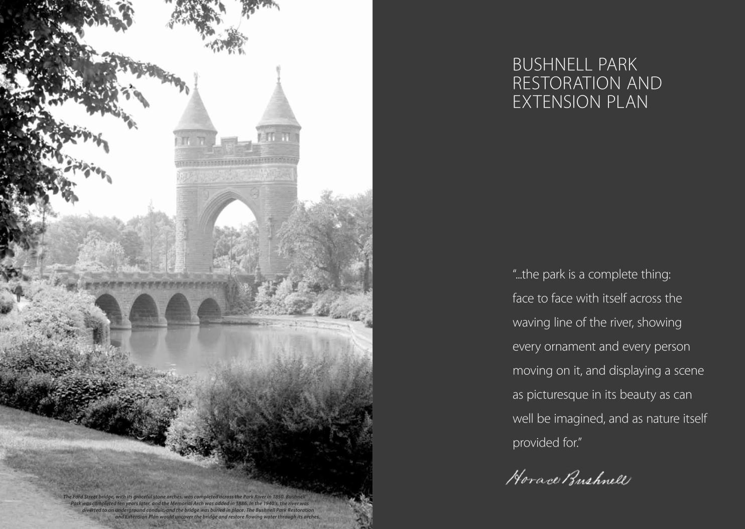
bUSHNELL PARK RESTORATION AND ExTENSION PLAN
The Ford Street bridge, with its graceful stone arches, was completed across the Park River in 1850. Bushnell Park was completed ten years later, and the Memorial Arch was added in 1886. In the 1940’s, the river was
diverted to an underground conduit, and the bridge was buried in place. The Bushnell Park Restoration and Extension Plan would uncover the bridge and restore flowing water through its arches.
56 57iQUILT OVERVIEW
GR
EEN
WA
LK
N1/8 of a mile
(at average walking speed for human or hart, this takes about 2.5 minutes)
0‘ 100‘ 200‘ 400‘
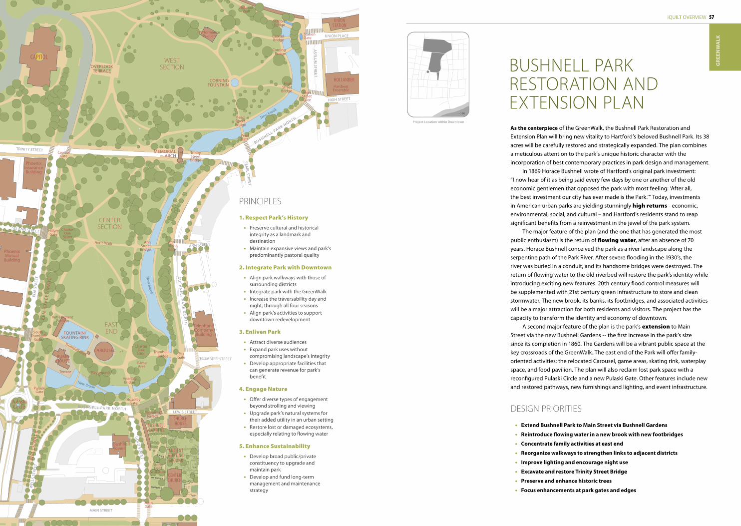
as the centerpiece of the GreenWalk, the Bushnell Park Restoration and Extension Plan will bring new vitality to Hartford’s beloved Bushnell Park. Its 38 acres will be carefully restored and strategically expanded. The plan combines a meticulous attention to the park’s unique historic character with the incorporation of best contemporary practices in park design and management.
In 1869 Horace Bushnell wrote of Hartford’s original park investment: “I now hear of it as being said every few days by one or another of the old economic gentlemen that opposed the park with most feeling: ‘After all, the best investment our city has ever made is the Park.’” Today, investments in American urban parks are yielding stunningly high returns - economic, environmental, social, and cultural – and Hartford’s residents stand to reap significant benefits from a reinvestment in the jewel of the park system.
The major feature of the plan (and the one that has generated the most public enthusiasm) is the return of flowing water, after an absence of 70 years. Horace Bushnell conceived the park as a river landscape along the serpentine path of the Park River. After severe flooding in the 1930’s, the river was buried in a conduit, and its handsome bridges were destroyed. The return of flowing water to the old riverbed will restore the park’s identity while introducing exciting new features. 20th century flood control measures will be supplemented with 21st century green infrastructure to store and clean stormwater. The new brook, its banks, its footbridges, and associated activities will be a major attraction for both residents and visitors. The project has the capacity to transform the identity and economy of downtown.
A second major feature of the plan is the park’s extension to Main Street via the new Bushnell Gardens -- the first increase in the park’s size since its completion in 1860. The Gardens will be a vibrant public space at the key crossroads of the GreenWalk. The east end of the Park will offer family-oriented activities: the relocated Carousel, game areas, skating rink, waterplay space, and food pavilion. The plan will also reclaim lost park space with a reconfigured Pulaski Circle and a new Pulaski Gate. Other features include new and restored pathways, new furnishings and lighting, and event infrastructure.
bUSHNELL PARK RESTORATION AND ExTENSION PLAN
PRINCIPLES
1. Respect Park’s History
• Preserve cultural and historical integrity as a landmark and destination
• Maintain expansive views and park’s predominantly pastoral quality
2. Integrate Park with Downtown
• Align park walkways with those of surrounding districts
• Integrate park with the GreenWalk• Increase the traversability day and
night, through all four seasons• Align park’s activities to support
downtown redevelopment
3. Enliven Park
• Attract diverse audiences• Expand park uses without
compromising landscape’s integrity• Develop appropriate facilities that
can generate revenue for park’s benefit
4. Engage Nature
• Offer diverse types of engagement beyond strolling and viewing
• Upgrade park’s natural systems for their added utility in an urban setting
• Restore lost or damaged ecosystems, especially relating to flowing water
5. Enhance Sustainability
• Develop broad public/private constituency to upgrade and maintain park
• Develop and fund long-term management and maintenance strategy
DESIGN PRIORITIES
• extend Bushnell park to Main Street via Bushnell Gardens
• Reintroduce flowing water in a new brook with new footbridges
• Concentrate family activities at east end
• Reorganize walkways to strengthen links to adjacent districts
• improve lighting and encourage night use
• excavate and restore Trinity Street Bridge
• preserve and enhance historic trees
• Focus enhancements at park gates and edges
Project Location within Downtown
N
CenTerChurCh
ChurChhouseBushnell
gardens
CaPiTol
unionsTaTion
hollanderHartbeatEnsemble
BushnellTower
MainGate
PhoenixMutual
Building
PhoenixInsuranceBuilding
Telephone Company Building
CAROUSEL
RefreshmentPavilion
PUMPHOUSE
FOUNTAIN/SKATING RINK
New Brook
New
Brook
New Brook
TrumbullBridge
AnnStreet
Bridge
Ann’s Walk
Trumbull Walk
PearlStreetBridge
TrinityStreetBridge
HighStreet
Bridge
CorningBridge
CapitolBridge
StationBridge
CORNINGFOUNTAIN
MEMORIALARCH
OVERLOOKTERRACE
ELM
ST
RE
ET
MA
LL
WE
LLS
WA
LKPerformance
Pavilion
anCienTBuryingground
Stone Field
Sculpture
HoadleyBridge
GameArea
CharterOak
Scion
CharterOak
Scion
PlaygroundTerrace
FoxGate
PulaskiGate
HillyerGate
CapitolGate
HoadleyGate
HeubleinTerrace
AnnStreetGate
PearlGate
SouthTrumbull
Gate
StationGate
HighStreetGate
UNION PLACE
HIGH STREET
ASYLU
M STREET
ANN STREET
PEARL STREET
ELM
STR
EET
GO
LD STREET
MAIN STREET
TRUMBULL STREET
LEWIS STREET
TRINITY STREET
WEL
LS S
TREE
T
SO. ANN STREET
RailroadWall
PulaskiCircle
BUSHNELL PARK NOR TH
B U S H N E L L PA R K N O R T H
BU
SH
NE
LL PAR
K N
OR
TH
WESTSECTION
CENTERSECTION
EASTEND
58 59iQUILT OVERVIEW
GR
EEN
WA
LK
BushnellPark
GULLY BROOK
PARK RIVER
KeneyPark
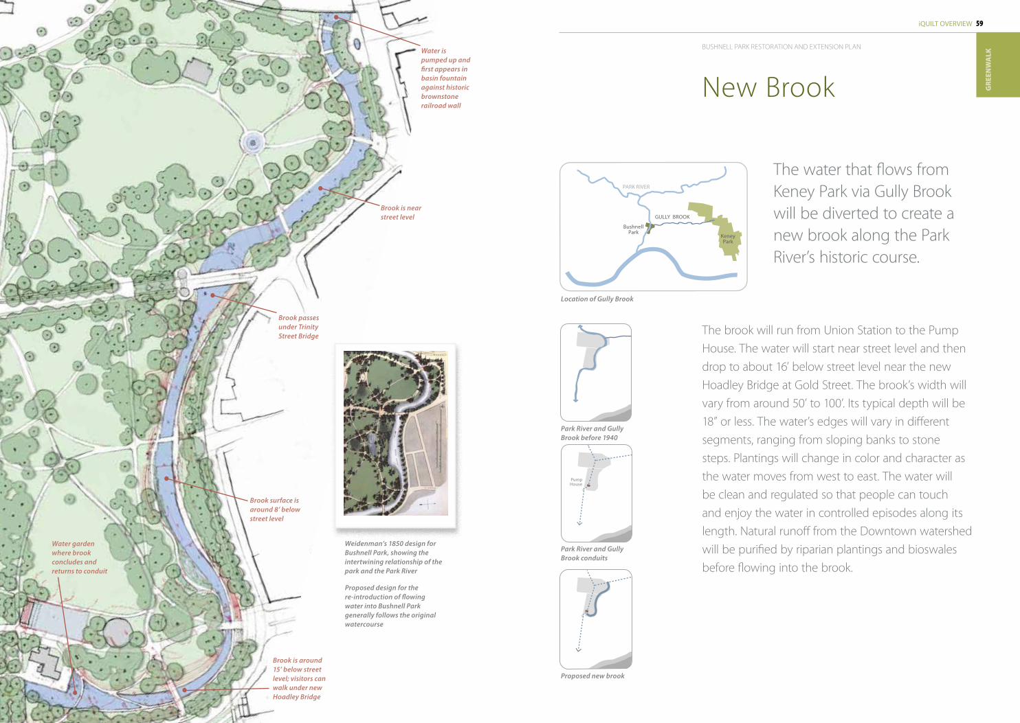
Water is pumped up and first appears in basin fountain against historic brownstone railroad wall
Brook passes under Trinity Street Bridge
Brook surface is around 8’ below street level
Water garden where brook concludes and returns to conduit
Brook is near street level
The brook will run from Union Station to the Pump House . The water will start near street level and then drop to about 16’ below street level near the new Hoadley bridge at Gold Street . The brook’s width will vary from around 50’ to 100’ . Its typical depth will be 18” or less . The water’s edges will vary in different segments, ranging from sloping banks to stone steps . Plantings will change in color and character as the water moves from west to east . The water will be clean and regulated so that people can touch and enjoy the water in controlled episodes along its length . Natural runoff from the Downtown watershed will be purified by riparian plantings and bioswales before flowing into the brook .
The water that flows from Keney Park via Gully brook will be diverted to create a new brook along the Park River’s historic course .
New brook
Weidenman’s 1850 design for Bushnell Park, showing the intertwining relationship of the park and the Park River
Proposed design for the re-introduction of flowing water into Bushnell Park generally follows the original watercourse
Park River and Gully Brook before 1940
Location of Gully Brook
Park River and Gully Brook conduits
Pump House
Proposed new brook
Brook is around 15’ below street level; visitors can walk under new Hoadley Bridge
bUSHNELL PARK RESTORATION AND ExTENSION PLAN