Embed Size (px)
Citation preview
Integrating Numerical Modelling
into the Groundwater Policy
Assurance Process
Dan Palombi, Alberta Geological Survey
April 10, 2014
Presentation at Watertech 2014 – Regulatory Session
2
Outline
Overview of AGS Groundwater Program
Project regions and current initiatives
Modelling results
Towards integrating numerical modelling into a
regulatory framework

3 3
AGS Groundwater Program
Overview
• Study, map and quantify Alberta’s groundwater and brine
resources
• Focused on regional saline and non-saline aquifers exploited by
energy development
• Regional geological and hydrogeological mapping, groundwater
flow modelling, and evaluation of management tools
I. Characterize the natural system
II. Understand dynamics of groundwater system
under development
III. Develop decision support tools for resource
management, regulation, and policy
development
3 Phases of the Program
Council of Canadian Academics, 2009

4
Regional Project Areas
• Future study areas will focus in
regions with intense energy
development
• Phased approach to study area
characterization
4
Regional
Groundwater
Model

5
Phase II Modelling Objectives
Assist regulator(s) of the Water Act using groundwater flow models required to:
Evaluate groundwater authorizations
Support a change from well by well (Q20) evaluations to cumulative impact based assessments
Understand groundwater resources and patterns of development
Generate regional models to assess water-balance, drawdown and yield forecasting
Identify current areas of stress to groundwater and surface water resources
Enable scenario modelling to evaluate future groundwater developments
6
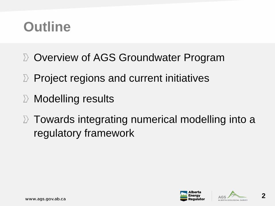
Modelling Approach
Nested scales
Enables basin- and regional-scale models to inform
management-scale objectives
Basin- and regional-scale models ensure appropriate
boundary conditions, spatial flexibility, and cumulative
effects assessment
Basin wide Regional Sub-basin
6
7
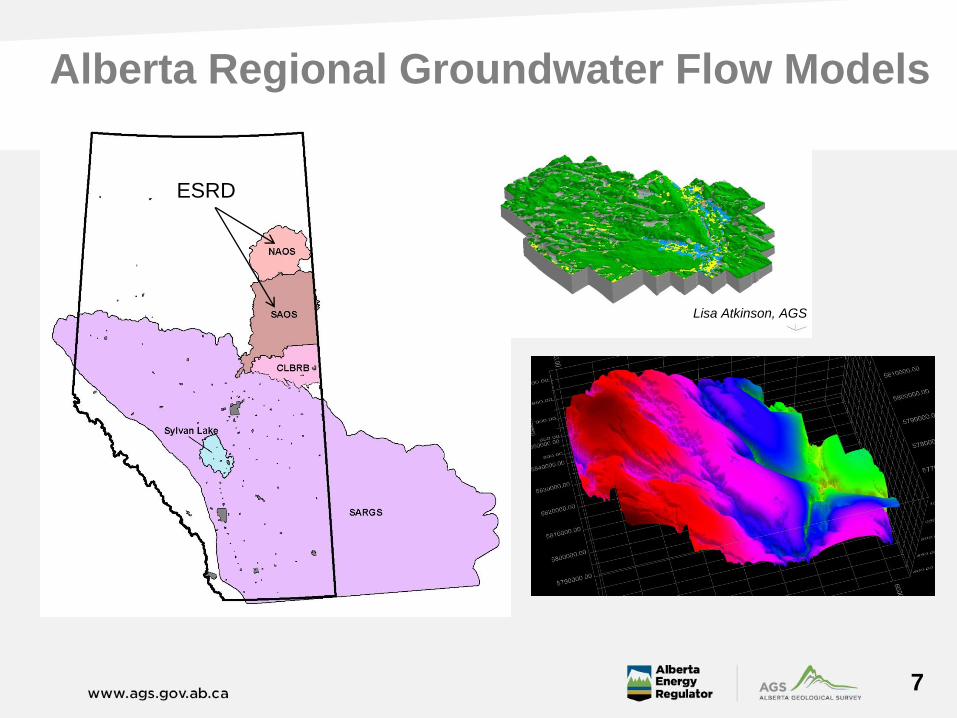
Alberta Regional Groundwater Flow Models
ESRD
Lisa Atkinson, AGS
8
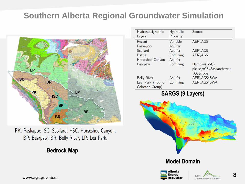
Southern Alberta Regional Groundwater Simulation
Bedrock Map
SARGS (9 Layers)
Model Domain

9
Southern Alberta Regional Groundwater Simulation
1st order regional flow model
Successfully calibrated,
steady state Modflow model
Indicates regional flow
patterns
Serves as foundational model
for higher resolution models
Enables rapid regional water
budget calculations
Provides lateral and vertical
boundary conditions for
management-scale models
10
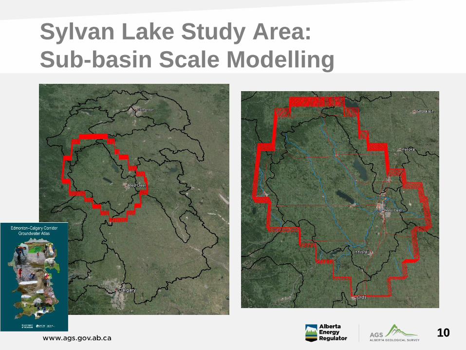
Sylvan Lake Study Area:
Sub-basin Scale Modelling
10
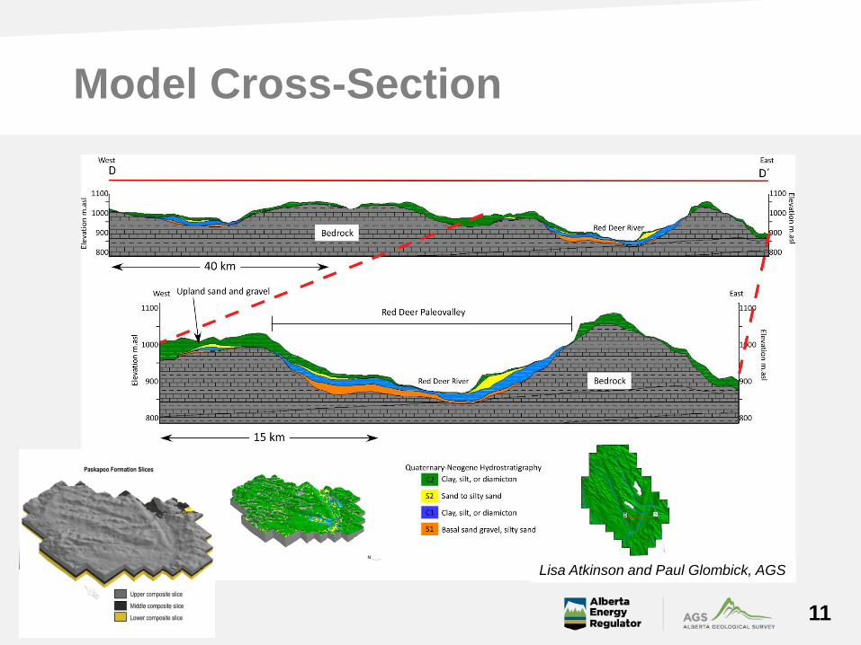
Model Cross-Section
11
Lisa Atkinson and Paul Glombick, AGS
Phase III Regulatory Development Targets
12
Quantify cumulative effects
Assess groundwater/surface water interaction
Advance current groundwater management framework
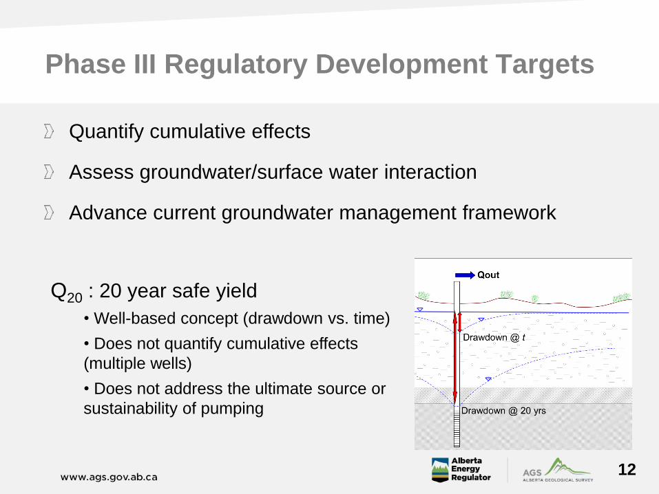
Q20 : 20 year safe yield
• Well-based concept (drawdown vs. time)
• Does not quantify cumulative effects
(multiple wells)
• Does not address the ultimate source or
sustainability of pumping
What Are Others Doing?
13
Water resources management in The Netherlands and
United Kingdom (NGMS)
Support continued geological mapping and 3-D modelling
Tiered approach to groundwater resource management
Develop groundwater flow models with results freely
available to regulator, industry & public
Models are hosted & run within updateable architecture
to adapt to increased model complexity
NGMS – The National Groundwater Modelling
System for England and Wales
Purpose of NGMS:
Manage sustainable development of groundwater
resources
Identify sustainable yield of groundwater units
Regulate extractions and their impacts on springs, rivers,
wetlands and existing licenses
Conduct strategic planning for European Commission
directives (e.g., Water Framework Directive)
Provide water availability forecasts
14
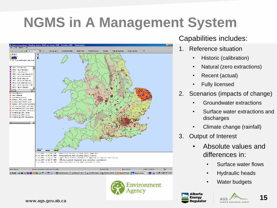
NGMS in A Management System
15
Capabilities includes:
1. Reference situation
• Historic (calibration)
• Natural (zero extractions)
• Recent (actual)
• Fully licensed
2. Scenarios (impacts of change)
• Groundwater extractions
• Surface water extractions and
discharges
• Climate change (rainfall)
3. Output of Interest
• Absolute values and
differences in:
• Surface water flows
• Hydraulic heads
• Water budgets
AGS-ESRD-Deltares Project: Starting Phase III
Collaboration between governments of Alberta and Netherlands initiated in October
2011
Project initiated in August 2012 with support from AI-EES which resulted in 4 technical
workshops and reporting
Implementing a regulatory groundwater framework
Mid- and long-term numerical modelling approach/workflow
Utilization of airborne geophysics in groundwater resource assessments
Uncertainty analysis in water resources
Technology for sharing and displaying groundwater information
Types of information that are interesting and useful
Methods and technology to update models
The ability for standard procedures to be coded into a system
The ways data can be stored, retrieved and disseminated widely
16
17
Phase III: The Link Between Models and Managers
Flood Early Warning System (FEWS)
Creates scientific linkage between regulators, model developers,
managers and the public
Run & view model results
Configure FEWS to meet Alberta specific needs
Compare model results from different scenarios
Pre-defined metrics, graphs & thresholds
Key is distributing information
17
18
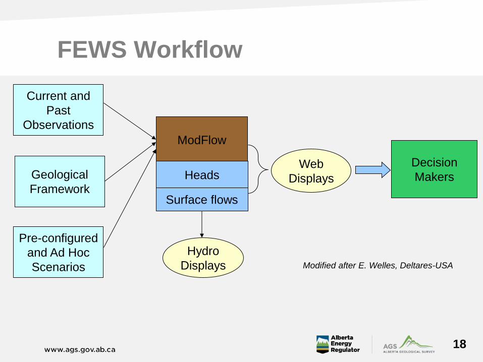
FEWS Workflow
Current and
Past
Observations
Web
Displays
ModFlow
Heads
Surface flows
Pre-configured
and Ad Hoc
Scenarios
Hydro
Displays
Decision
Makers
Modified after E. Welles, Deltares-USA
Geological
Framework

19
Integration of Numerical Model in FEWS
About FEWS:
• The software is free
• Any model can be linked to
FEWS
• New displays can be added
to the user interface
• Wide variety of data can be
imported, displayed and used
in the models
• New data can be added
anytime
• Output can be automatically
formatted and posted to a
web server
• Support tools should provide additional insight on hydrogeological system and
realistic appraisals of an aquifer’s potential for development over the medium and
long term time scales.
20
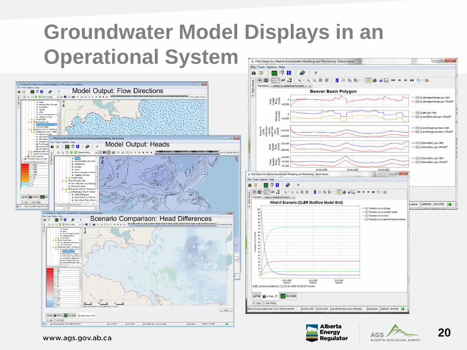
Groundwater Model Displays in an
Operational System
20
20
21
Summary
AGS Groundwater Program is focused on identifying, characterizing
and quantifying Alberta’s groundwater resources throughout the
province
Our objective is to provide AER, GoA, industry, and public with
peer-reviewed scientific research, mapping and reporting on
Alberta’s groundwater
Current initiatives include
Publication of Cold Lake Beaver River Basin Groundwater Atlas
Complete and publish regional scale SARGS model
Sylvan Lake sub-basin groundwater flow modelling and management
system
Linking management tools to policy and regulatory development
Evaluating architecture to host and allow for ongoing refinements to
groundwater flow models
21
22
Acknowledgments
Steve Wallace, Andy Ridge
Rolf Farrell, Mark Whiteman
Bennie Minnema, Edwin Welles & Peter Vermeulen
Ministry of Economic Affairs, Agriculture
and Innovation, The Netherlands
Jon Sweetman