Embed Size (px)
Citation preview
INTEGRATED GEOGRAPHICAL BUFFERING SYSTEM FOR LAND TAXATION IN SRI LANKA
Ravindra S. Thilakarathnea, Jagath Gunatilakeb, JAS Jayakodya
aFaculty of Geomatics, Sabaragamuwa University of Sri Lanka, P.O. Box 02, Belihuloya, Sri Lanka – (ravin, swarna)@sab.ac.lk, http://www.sab.ac.lk
bPostgraduate Institute of Science, University of Peradeniya, Peradeniya, Sri Lanka - [email protected] , http://www.pgis.ac.lk
KEY WORDS: Land, GIS, Database, Satellite, Imagery ABSTRACT Land property has value because it provides amenities and satisfactions of living, as in the case of residences and services, while property taxes are essentially concerned with improvements to the land. The methods used for land value taxation are varied and seem quite complicated in most developing countries. And most of the issues associated with land taxation in developing countries are also relevant to Sri Lanka. It has been financially costly, since there is no systematic and easily updateable land property rating system covering the entire country which gives descriptions and records of land values functional to socio-economic and infrastructural changes with the rapid growth of population in Sri Lanka and the existing various land valuation records are disparate, incomplete and very much out of date.Integrated Geographical Buffering System (IGBS) is an alternative solution for land valuation, hence to retain as a graphical database for land taxation over georeferenced and georectified high resolution satellite background imagery through a computer environment to identify and map all land properties, classify, analyze market data, value its price in relation to streets and other facilities, identify owners and tax payers and finally to simplify and improve proper land taxation roles through the use of better techniques for the effective development of the country.
1. INTRODUCTION
Land valuation is the art and science of assessing the value of land property. The value of a land property is determined by demand and supply of the land property in the market. The land parcel value mainly depends on its location while a number of physical and socio-economic characteristics are intrinsic to the land. The landowner is liable to pay the rates unless exempted by local governments, even very low income groups. A wide verity of land tax layouts are already being used in developing countries. In Sri Lanka there are several taxes imposed by the central government which have a bearing on land and the valuation process is traditionally accounted by the valuers’ expert knowledge of a locality. The process of valuation may be described as the carefully considered estimate of worth of landed property based on experience and judgment by identifying and assessing the characteristics of a given land. The purpose of valuation is, however, to determine “value”, a term generally prefaced by some description such as market value or benefit value. In general, lack of information, funds, shortage of technical and administrative personnel delay implementation of the needed large scale land valuation activities. However, the determination of a land parcel value depends on a number of physical and economic characteristics which must be taken into consideration very carefully in a land valuation procedure. Some of these characteristics are intrinsic to the land; others are external or environmental factors. These factors can be determined in an objective way but there is always a certain degree of subjectivity that is difficult to measure in the valuation process [6]. Locational influences on property value are widely regarded as the most important, yet their incorporation into valuation methodology is often implicit. GIS-based value maps are introduced as a means of displaying variations in value at the
individual property level. There are many property market characteristics that make valuation a difficult and often subjective task that is dependent on a high degree of experience and local knowledge, for example the heterogeneity of each interest, economic influences at the national, regional and local scales. These characteristics cannot be altered and indeed make valuation a challenging profession. However, it would be seem prudent to minimize valuation a complexity by improving data accessibility and dissemination [4].
2. EXISTING LAND VALUATION METHODS
The use of a particular property valuation technique is dependent on property type and the purpose of the valuation [3]. 2.1 Comparative Method
This method assumes that the market value is equal to the price recently paid for a similar property or interested in land. The valuer’s problem is to determine what the market considers to be recent and similar. Adjustments may need to be made for differences between the properties used in the comparison and changes that have subsequently taken place in the market or are of a structural nature. If an almost identical house were recently sold next door for a known price but which lacked a particular facility such as a garage or central heating, then slightly different assessment would be expected. The approach is often the most simple and efficient means of determining market value, especially for single-family residential properties in an active market. 2.2 Income Method
This method is also a comparative method and holds that the market value of an interest in land is equal to the present value of the net income that should in future come from the land. The
163
The International Archives of the Photogrammetry, Remote Sensing and Spatial Information Sciences. Vol. XXXVII. Part B4. Beijing 2008
net income is the gross income less the cost of overheads, such as depreciation of the building stock and its maintenance and upkeep. It is equivalent to a national rent and must be discounted at an appropriate rate. The valuer's problem is to determine the net benefits that should come from the land by comparison with similar properties; and then to determine the market discount rate by analyzing recent sales of similar assets. 2.3 Cost Method
This is also known as the contractor's method or the quantity survey approach. It assumes that the costs of replacement, less appropriate depreciation, are equal to the value. The problem is to assemble suitable cost data, including the cost of the site, and to estimate depreciation rates. The method is particularly useful for insurance purposes, where the cost of site clearance may be added to cover the possibility of a building being destroyed by fire, and for valuing new constructions.
3. PROBLEM SOLUTION
Integrated Geographical Buffering System (IGBS) is the most effective and easy to comprehend; It provides quick and cheap technological platform on which to base such an analysis and an initial stage is the spatial representation of property information in the form of value maps. Capabilities of Geographical Information System not only facilitate the organization and management of geographic data, but they also enable researchers to take full advantage of location information contained in these databases to support the application of spatial statistical and spatial econometric tools[1]. Due to the complexity of land valuation process, providing property owners with an easy understood explanation of how their property has been valued is a continual challenge for planners and assessors. The Integrated Geographical Buffering System based on GIS and GPS fulfills the above requirements executing all these complex tasks. Thus, using Buffering modules, a visual value model and required valuation maps can be created. 3.1 Materials and Methods
3.1.1 Study Area The study area was 4 (square kilometers) ground area in Gampola region in Kandy District in Central Province of Sri Lanka where the land is not homogeneous but full of varieties, which consists of a land cover of land parcels, buildings, transportation (roads/railways), vegetations/cultivations and other infrastructures. 3.2 Activities
3.2.1 Preliminary Investigation ArcView GIS Version 3.1 was used for different purposes during test phase. Before initializing the test phase high resolution satellite background imagery which covers the study area was preliminarily investigated in detail and realized following findings.
Storage size of the satellite image in tiff type was around 4 MB.
Study area was with in a single satellite image. Linear features such as parcel boundaries, road edges could
be identified.
Some linear features could not be clearly identified without a special experience.
3.2.2 Georeferencing the Satellite Image The process of assigning coordinates to points on the image of known locations easily distinguished on terrain was carried out from Ground to Image. These well-identified points on the image were determined on the ground by means of handheld GPS (GeoExplora XT) with the basic technical performances of submeter accuracy, 12 channels, 1 Hz position update rate and 30seconds typical time for initial fixation [2]. A total of 8 well distributed points were measured in the vicinity. In choosing points preference was given to stable visible structures in order to setup a network of points that could be easily located even in later series of data collection. Making use of 4 Ground Control Points (GCPs) and 4 check points (CPs) in correspondence to the best fit of the entire image gave the following interpretation (Fig. 1). Projection information used in georeferencing; Projection Type Transverse Mercator Longitude of central meridian 80:46:18.160 E Spheroid Name Everest Latitude of origin of projection 07:00:01.725 N Datum Name Everest False easting 200Km Scale factor at central meridian 0.99992384 False nothing 200Km 3.2.3 Parcel Boundary Identification and Weight Assigning Enlarged satellite base image was more useful for tracing off parcel boundaries by interactive digitizing (polygon mode) in which the results of each operation were immediately shown on a graphic screen, all the visible and identifiable boundaries out of fixed (specific) and general (uncertain and variable) boundaries could be digitized on desktop satellite image. And the other ambiguous (uncertain and unsettled) boundaries could be re-determined by directly through field verifications and indirectly from other sources such as existing data records in land settlement office, land registration office, planning office etc. along with a long visual inspection. Using raster based GIS, unit land value was defined as a weighted average of a number of factors affect valuations; Land-use category (residential, industrial, commercial, agricultural etc.) Site/location Amenities enjoyed Quality of infrastructure Building Size Design Shape Construction quality Construction materials Other building features Age/extent of depreciation Population (No. in house hold) Land ownership (Freehold, Leasehold) F
164
The International Archives of the Photogrammetry, Remote Sensing and Spatial Information Sciences. Vol. XXXVII. Part B4. Beijing 2008
Figure.1 Graphical Land Register
The required data for land valuation analysis were derived from thematic and topographical maps and from the other related textual records. Land parcel values were determined by the
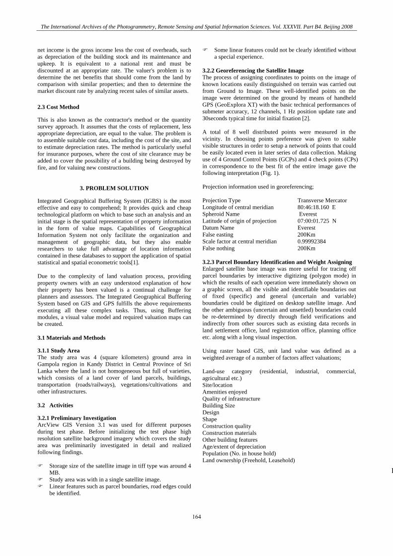
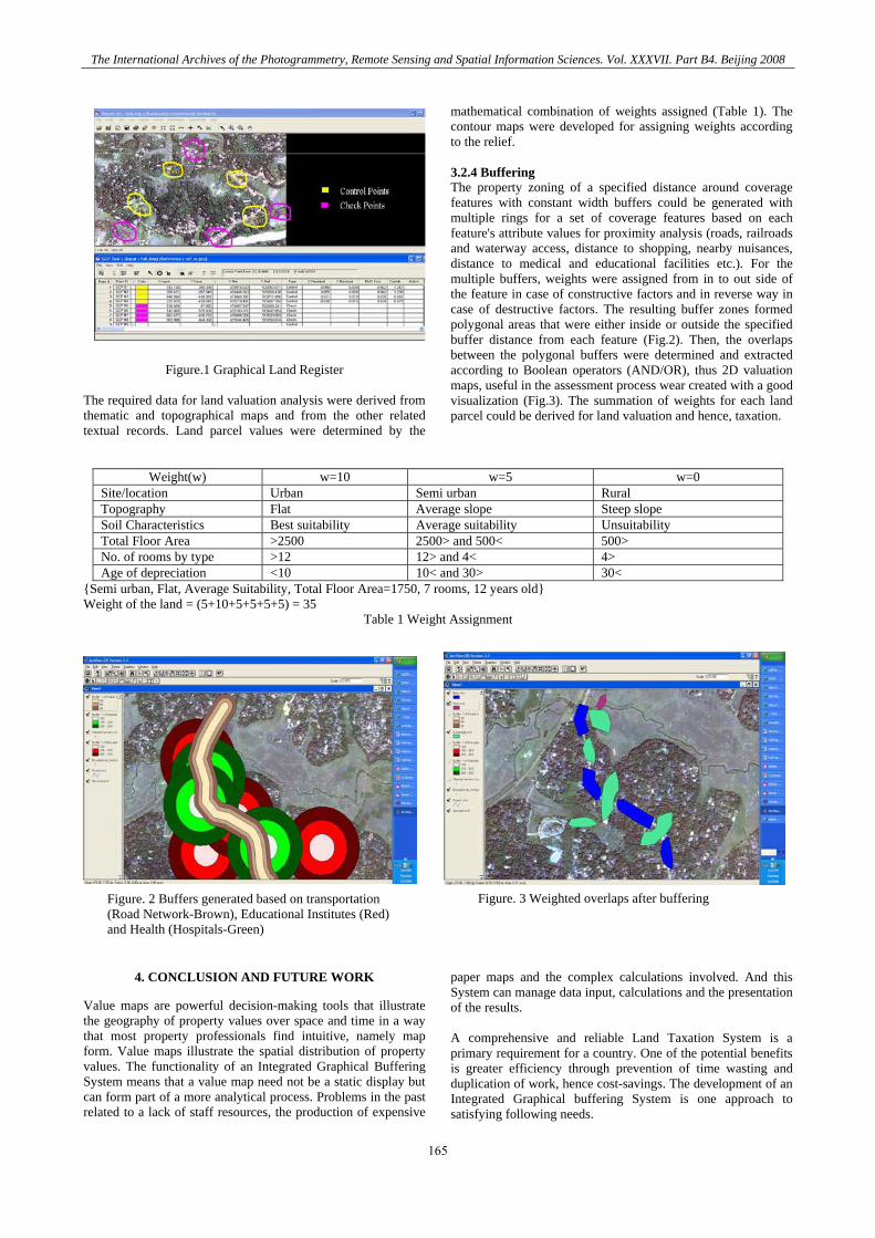
mathematical combination of weights assigned (Table 1). The contour maps were developed for assigning weights according to the relief. 3.2.4 Buffering The property zoning of a specified distance around coverage features with constant width buffers could be generated with multiple rings for a set of coverage features based on each feature's attribute values for proximity analysis (roads, railroads and waterway access, distance to shopping, nearby nuisances, distance to medical and educational facilities etc.). For the multiple buffers, weights were assigned from in to out side of the feature in case of constructive factors and in reverse way in case of destructive factors. The resulting buffer zones formed polygonal areas that were either inside or outside the specified buffer distance from each feature (Fig.2). Then, the overlaps between the polygonal buffers were determined and extracted according to Boolean operators (AND/OR), thus 2D valuation maps, useful in the assessment process wear created with a good visualization (Fig.3). The summation of weights for each land parcel could be derived for land valuation and hence, taxation.
Weight(w) w=10 w=5 w=0 Site/location Urban Semi urban Rural Topography Flat Average slope Steep slope Soil Characteristics Best suitability Average suitability Unsuitability Total Floor Area >2500 2500> and 500< 500> No. of rooms by type >12 12> and 4< 4> Age of depreciation <10 10< and 30> 30<
{Semi urban, Flat, Average Suitability, Total Floor Area=1750, 7 rooms, 12 years old} Weight of the land = (5+10+5+5+5+5) = 35
Table 1 Weight Assignment
Figure. 3 Weighted overlaps after buffering Figure. 2 Buffers generated based on transportation (Road Network-Brown), Educational Institutes (Red)and Health (Hospitals-Green)
4. CONCLUSION AND FUTURE WORK
Value maps are powerful decision-making tools that illustrate the geography of property values over space and time in a way that most property professionals find intuitive, namely map form. Value maps illustrate the spatial distribution of property values. The functionality of an Integrated Graphical Buffering System means that a value map need not be a static display but can form part of a more analytical process. Problems in the past related to a lack of staff resources, the production of expensive
paper maps and the complex calculations involved. And this System can manage data input, calculations and the presentation of the results. A comprehensive and reliable Land Taxation System is a primary requirement for a country. One of the potential benefits is greater efficiency through prevention of time wasting and duplication of work, hence cost-savings. The development of an Integrated Graphical buffering System is one approach to satisfying following needs.
165
The International Archives of the Photogrammetry, Remote Sensing and Spatial Information Sciences. Vol. XXXVII. Part B4. Beijing 2008
Acquiring, storing and retrieving information about land for the purpose of valuation and taxation.
Compiling some form of tax record that is complete, up to date and reliable.
Displaying in graphic form different combinations of spatial data especially those relating to valuation and to land parcels.
Analyzing and processing those data to produce meaningful land valuation, monitoring the market value of land parcel in relation to streets and other amenities, facilities and utilities.
And a protection is needed to the data base itself so-called ‘Hackers’ must be prevented from entering the system and, for example, changing the names and figures of the registered owner of a property. This study, however, aims at the most basic environment in order to remain relatively simple and manageable and would deserve further investigation providing the basis for further researches in advanced Real Time Land Valuation Systems.
REFERENCES
[1] Can A., 1998, GIS and Spatial Analysis of Housing and Mortgage Markets, Journal of Housing Research, Vol. 9, Issue 1.
[2] GeoXT™ handheld from the Trimble® GeoExplorer®
2005 series, Product Info, http://www.trimble.com/geoxt.shtml
[3] Peter F. Dale and John D. McLaughlin, Land Information
Management, An Introduction with Special Reference to Cadastral Problems in Third World Countries, English Language Book Society/Oxford University Press, 1988.
[4] Wyatt, P.J., 1995, Using a Geographical Information System
for Property Valuation, Journal of property Valuation & Investment, Vol. 14, No. 1.
[5] Wyatt, P.J., 1997, The Development of a GIS-Based
Property Information System for Real Estate Valuation, International Journal of Geographical Information Systems, Vol. 11, No. 5.
[6] Yomralioglu, T., 1993a, The Investigation of a Value-based
Urban Land Readjustment Model and its Implementation Using Geographical Information Systems, PhD. Thesis, Department of Surveying University of Newcastle upon Tyne, UK.
BIOGRAPHICAL NOTES
Academic experience: M.Phil. (Land Information Systems) - University of Peradeniya, Sri Lanka (Reading), B.Sc. (Hons.) Surveying Sciences - Sabaragamuwa University of Sri Lanka, Current position: Assistant Lecturer - Sabaragamuwa University of Sri Lanka, M.Phil. Student - University of Peradeniya, Sri Lanka Practical experience: Land Surveying, Cadastral Mapping Activities in Home and International relations: Member, Royal Institution of Charted Surveyors (Member No.1266757), International Society for Photogrammetry and Remote Sensing Commission IV - Geo-Databases and Digital Mapping Working Group IV/8 - Spatial Data Integration for Emergency Services, WG IV/8 Members (2004-2008) http://www.fes.uwaterloo.ca/research/isprs/members.htm
CONTACTS
Ravindra S. Thilakarathne Department of Surveying and Geodesy Faculty of Geomatics Sabaragamuwa University of Sri Lanka P.Box:02, Belihuloya SRI LANKA Tel.: + 94 45 2280010 Fax: + 94 45 2280010 Email: [email protected] Web site: http://www.sab.ac.lk
166


![ADM315-Workload Analysis 06 [Table Buffering]](https://img.pdfslide.us/doc/110x75/5695cee41a28ab9b028ba9a9/adm315-workload-analysis-06-table-buffering.jpg)