Embed Size (px)
Citation preview
Review Article
Influences of Climate and Agricultur e on Water and BiogeochemicalCycles: Kabini Critical Zone ObservatoryM SEKHAR1,2,*, J RIOTTE2,3, L RUIZ2,4, P JOUQUET2,5 and J J BRAUN3
1Indian Institute of Science, 560012 Bangalore, India2Indo-French Cell for Water Sciences, Indian Institute of Science, Bangalore, India3IRD, GET UMR 5563 (Univ. Toulouse, CNRS, IRD), 31400 Toulouse, France4INRA, UMR 1069 SAS, 35000 Rennes, France5IRD, iEES, 93143 Bondy, France
(Received on 30 April 2016; Accepted on 25 May 2016)
In the last decades, globally several small experimental watersheds were set up to study the climate and agriculturalinfluences on water and biogeochemical cycles. Recently, the concept and importance of Critical Zone Observatory (CZO)was made and this resulted in developing such observatories in several countries including a global network of CZOs. TheCZOs combine characterization, long term monitoring and modeling to allow understanding of the processes governingwater and biogeochemical cycles in a small experimental watershed or network of watersheds. The Kabini CZO too wasformed from similar twin experimental watersheds (forested and cultivated) developed during the last decade in the Kabiniriver basin in the south western part of India. A summary of the salient studies performed on water and biogeochemicalcycles under the influence of climate and agriculture during the last ten years in the Kabini CZO are reported here.
Keywords: Critical Zone Observatory, CZO, Small Experimental Watershed, Hydrology, Biogeochemistry.
*Author for Correspondence: E-mail: [email protected]
Proc Indian Natn Sci Acad 82 No. 3 July Spl Issue 2016 pp. 833-846 Printed in India. DOI: 10.16943/ptinsa/2016/48488
Introduction
The Earth Critical Zone is defined as “the thin layerbetween the top of the canopy and the bottom ofgroundwater aquifer in which complex interactionsinvolving rock, soil water, air and living organismsregulate the natural habitat and determine availabilityof life sustaining resources” (NRC report, 2001).Critical Zone Observatories (CZOs) have beenimplemented by the Earth Science community in thepast 25 years in several countries (Banwart et al.2013) with an aim to answer crucial environmentalquestions such as:
– What is the impact of land-use changes on thehydrological and biogeochemical fluxes exportedfrom watersheds?
– How climate variability controls the processesinvolved in water-soil-life interactions?
– What is the control of biosphere on thehydrological and biogeochemical cycles in the
different continental ecosystems at seasonal,yearly, decennial, and multi-decennialtimescales?
The strategies adopted to answer thesequestions are often integrated approaches onexperimental catchments, where hydrological andbiogeochemical studies can be coupled. Acquiringsimultaneously time series of climate, hydrology andgeochemical data over decades on river systems (bothsmall experimental watersheds and larger basins)representative of the diversity of ecosystems is pivotalfor the understanding of these processes, buildingintegrated modeling and for proposing predictivescenarios. Even though currently many CZOs(www.czen.org) are operating globally, very few wereset up in the tropics despite the huge importance ofthese regions in terms of population density, fast-changing land use, biodiversity hotspots, biomass stockon continents (humid forests), size of river systems,etc. In addition, rainfall in the tropics is mostly
834 M Sekhar et al.
governed by monsoon systems, which are fluctuatingperiodically but are also thought to be particularlysensitive to climate change. Vimal Singh (2015)presents the need for such CZO studies from Indiaperspective.
The Kabini Critical Zone Observatory
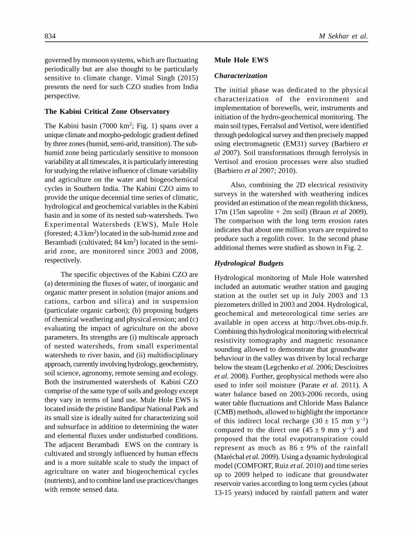
The Kabini basin (7000 km2; Fig. 1) spans over aunique climate and morpho-pedologic gradient definedby three zones (humid, semi-arid, transition). The sub-humid zone being particularly sensitive to monsoonvariability at all timescales, it is particularly interestingfor studying the relative influence of climate variabilityand agriculture on the water and biogeochemicalcycles in Southern India. The Kabini CZO aims toprovide the unique decennial time series of climatic,hydrological and geochemical variables in the Kabinibasin and in some of its nested sub-watersheds. TwoExperimental Watersheds (EWS), Mule Hole(forested; 4.3 km2) located in the sub-humid zone andBerambadi (cultivated; 84 km2) located in the semi-arid zone, are monitored since 2003 and 2008,respectively.
The specific objectives of the Kabini CZO are(a) determining the fluxes of water, of inorganic andorganic matter present in solution (major anions andcations, carbon and silica) and in suspension(particulate organic carbon); (b) proposing budgetsof chemical weathering and physical erosion; and (c)evaluating the impact of agriculture on the aboveparameters. Its strengths are (i) multiscale approachof nested watersheds, from small experimentalwatersheds to river basin, and (ii) multidisciplinaryapproach, currently involving hydrology, geochemistry,soil science, agronomy, remote sensing and ecology.Both the instrumented watersheds of Kabini CZOcomprise of the same type of soils and geology exceptthey vary in terms of land use. Mule Hole EWS islocated inside the pristine Bandipur National Park andits small size is ideally suited for characterizing soiland subsurface in addition to determining the waterand elemental fluxes under undisturbed conditions.The adjacent Berambadi EWS on the contrary iscultivated and strongly influenced by human effectsand is a more suitable scale to study the impact ofagriculture on water and biogeochemical cycles(nutrients), and to combine land use practices/changeswith remote sensed data.
Mule Hole EWS
Characterization
The initial phase was dedicated to the physicalcharacterization of the environment andimplementation of borewells, weir, instruments andinitiation of the hydro-geochemical monitoring. Themain soil types, Ferralsol and Vertisol, were identifiedthrough pedological survey and then precisely mappedusing electromagnetic (EM31) survey (Barbiero etal 2007). Soil transformations through ferrolysis inVertisol and erosion processes were also studied(Barbiero et al 2007; 2010).
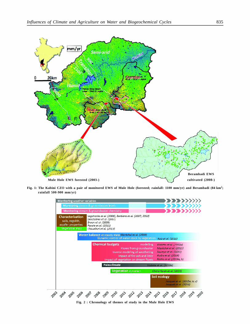
Also, combining the 2D electrical resistivitysurveys in the watershed with weathering indicesprovided an estimation of the mean regolith thickness,17m (15m saprolite + 2m soil) (Braun et al 2009).The comparison with the long term erosion ratesindicates that about one million years are required toproduce such a regolith cover. In the second phaseadditional themes were studied as shown in Fig. 2.
Hydrological Budgets
Hydrological monitoring of Mule Hole watershedincluded an automatic weather station and gaugingstation at the outlet set up in July 2003 and 13piezometers drilled in 2003 and 2004. Hydrological,geochemical and meteorological time series areavailable in open access at http://bvet.obs-mip.fr.Combining this hydrological monitoring with electricalresistivity tomography and magnetic resonancesounding allowed to demonstrate that groundwaterbehaviour in the valley was driven by local rechargebelow the steam (Legchenko et al. 2006; Descloitreset al. 2008). Further, geophysical methods were alsoused to infer soil moisture (Parate et al. 2011). Awater balance based on 2003-2006 records, usingwater table fluctuations and Chloride Mass Balance(CMB) methods, allowed to highlight the importanceof this indirect local recharge (30 ± 15 mm y–1)compared to the direct one (45 ± 9 mm y–1) andproposed that the total evapotranspiration couldrepresent as much as 86 ± 9% of the rainfall(Maréchal et al. 2009). Using a dynamic hydrologicalmodel (COMFORT, Ruiz et al. 2010) and time seriesup to 2009 helped to indicate that groundwaterreservoir varies according to long term cycles (about13-15 years) induced by rainfall pattern and water
Influences of Climate and Agriculture on Water and Biogeochemical Cycles 835
Fig. 2 : Chronology of themes of study in the Mule Hole EWS
Fig. 1: The Kabini CZO with a pair of monitored EWS of Mule Hole (forested; rainfall: 1100 mm/yr) and Berambadi (84 km2;rainfall 500-900 mm/yr)
Mule Hole EWS forested (2003-)
Berambadi EWS
cultivated (2008-)
836 M Sekhar et al.
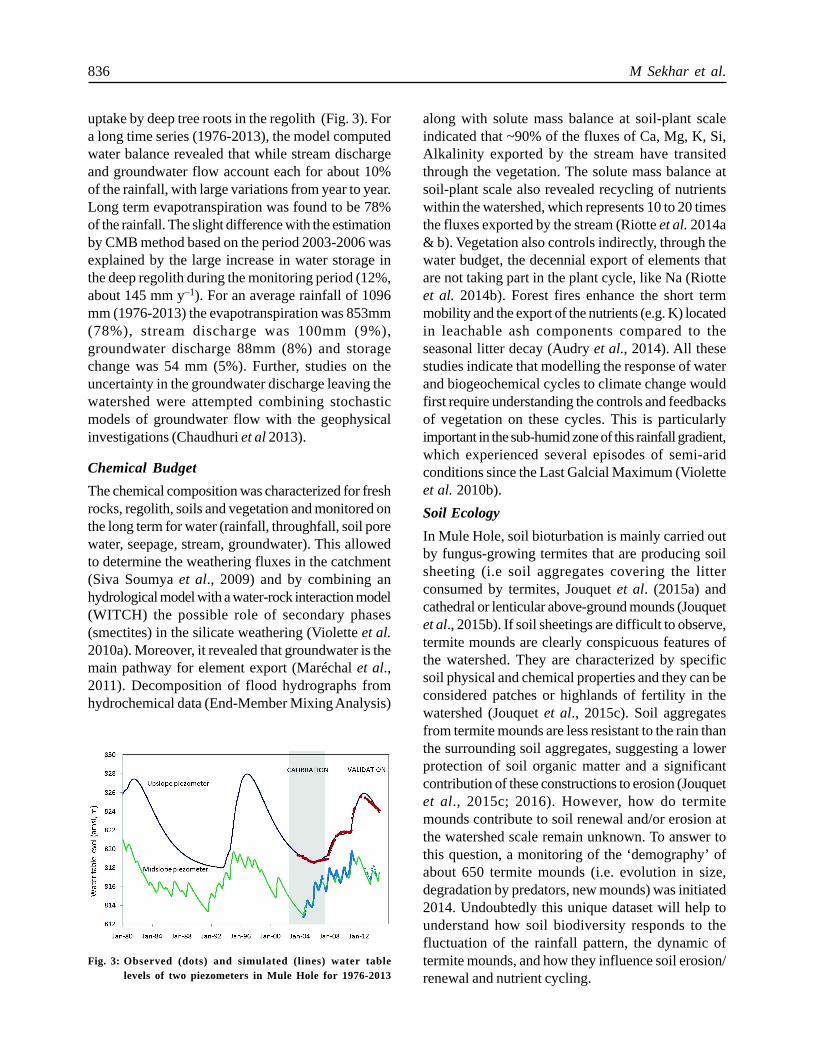
uptake by deep tree roots in the regolith (Fig. 3). Fora long time series (1976-2013), the model computedwater balance revealed that while stream dischargeand groundwater flow account each for about 10%of the rainfall, with large variations from year to year.Long term evapotranspiration was found to be 78%of the rainfall. The slight difference with the estimationby CMB method based on the period 2003-2006 wasexplained by the large increase in water storage inthe deep regolith during the monitoring period (12%,about 145 mm y–1). For an average rainfall of 1096mm (1976-2013) the evapotranspiration was 853mm(78%), stream discharge was 100mm (9%),groundwater discharge 88mm (8%) and storagechange was 54 mm (5%). Further, studies on theuncertainty in the groundwater discharge leaving thewatershed were attempted combining stochasticmodels of groundwater flow with the geophysicalinvestigations (Chaudhuri et al 2013).
Chemical Budget
The chemical composition was characterized for freshrocks, regolith, soils and vegetation and monitored onthe long term for water (rainfall, throughfall, soil porewater, seepage, stream, groundwater). This allowedto determine the weathering fluxes in the catchment(Siva Soumya et al., 2009) and by combining anhydrological model with a water-rock interaction model(WITCH) the possible role of secondary phases(smectites) in the silicate weathering (Violette et al.2010a). Moreover, it revealed that groundwater is themain pathway for element export (Maréchal et al.,2011). Decomposition of flood hydrographs fromhydrochemical data (End-Member Mixing Analysis)
along with solute mass balance at soil-plant scaleindicated that ~90% of the fluxes of Ca, Mg, K, Si,Alkalinity exported by the stream have transitedthrough the vegetation. The solute mass balance atsoil-plant scale also revealed recycling of nutrientswithin the watershed, which represents 10 to 20 timesthe fluxes exported by the stream (Riotte et al. 2014a& b). Vegetation also controls indirectly, through thewater budget, the decennial export of elements thatare not taking part in the plant cycle, like Na (Riotteet al. 2014b). Forest fires enhance the short termmobility and the export of the nutrients (e.g. K) locatedin leachable ash components compared to theseasonal litter decay (Audry et al., 2014). All thesestudies indicate that modelling the response of waterand biogeochemical cycles to climate change wouldfirst require understanding the controls and feedbacksof vegetation on these cycles. This is particularlyimportant in the sub-humid zone of this rainfall gradient,which experienced several episodes of semi-aridconditions since the Last Galcial Maximum (Violetteet al. 2010b).
Soil Ecology
In Mule Hole, soil bioturbation is mainly carried outby fungus-growing termites that are producing soilsheeting (i.e soil aggregates covering the litterconsumed by termites, Jouquet et al. (2015a) andcathedral or lenticular above-ground mounds (Jouquetet al., 2015b). If soil sheetings are difficult to observe,termite mounds are clearly conspicuous features ofthe watershed. They are characterized by specificsoil physical and chemical properties and they can beconsidered patches or highlands of fertility in thewatershed (Jouquet et al., 2015c). Soil aggregatesfrom termite mounds are less resistant to the rain thanthe surrounding soil aggregates, suggesting a lowerprotection of soil organic matter and a significantcontribution of these constructions to erosion (Jouquetet al., 2015c; 2016). However, how do termitemounds contribute to soil renewal and/or erosion atthe watershed scale remain unknown. To answer tothis question, a monitoring of the ‘demography’ ofabout 650 termite mounds (i.e. evolution in size,degradation by predators, new mounds) was initiated2014. Undoubtedly this unique dataset will help tounderstand how soil biodiversity responds to thefluctuation of the rainfall pattern, the dynamic oftermite mounds, and how they influence soil erosion/renewal and nutrient cycling.
Fig. 3: Observed (dots) and simulated (lines) water tablelevels of two piezometers in Mule Hole for 1976-2013
Influences of Climate and Agriculture on Water and Biogeochemical Cycles 837
Berambadi EWS
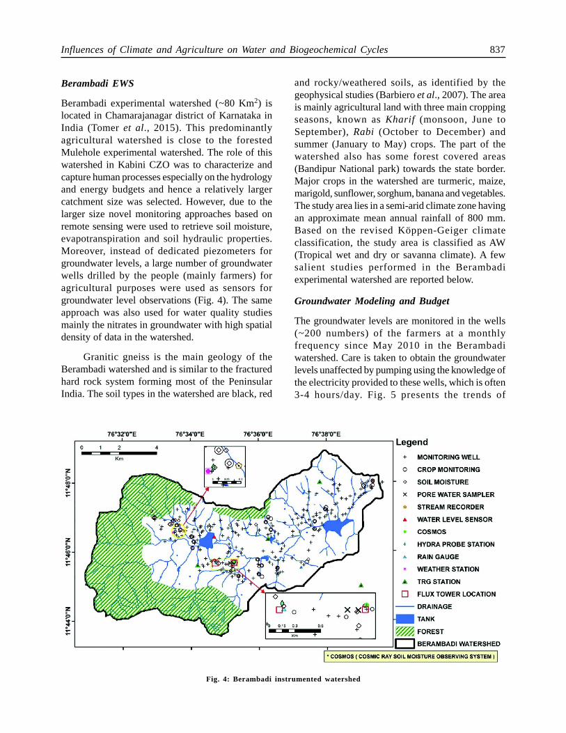
Berambadi experimental watershed (~80 Km2) islocated in Chamarajanagar district of Karnataka inIndia (Tomer et al., 2015). This predominantlyagricultural watershed is close to the forestedMulehole experimental watershed. The role of thiswatershed in Kabini CZO was to characterize andcapture human processes especially on the hydrologyand energy budgets and hence a relatively largercatchment size was selected. However, due to thelarger size novel monitoring approaches based onremote sensing were used to retrieve soil moisture,evapotranspiration and soil hydraulic properties.Moreover, instead of dedicated piezometers forgroundwater levels, a large number of groundwaterwells drilled by the people (mainly farmers) foragricultural purposes were used as sensors forgroundwater level observations (Fig. 4). The sameapproach was also used for water quality studiesmainly the nitrates in groundwater with high spatialdensity of data in the watershed.
Granitic gneiss is the main geology of theBerambadi watershed and is similar to the fracturedhard rock system forming most of the PeninsularIndia. The soil types in the watershed are black, red
and rocky/weathered soils, as identified by thegeophysical studies (Barbiero et al., 2007). The areais mainly agricultural land with three main croppingseasons, known as Kharif (monsoon, June toSeptember), Rabi (October to December) andsummer (January to May) crops. The part of thewatershed also has some forest covered areas(Bandipur National park) towards the state border.Major crops in the watershed are turmeric, maize,marigold, sunflower, sorghum, banana and vegetables.The study area lies in a semi-arid climate zone havingan approximate mean annual rainfall of 800 mm.Based on the revised Köppen-Geiger climateclassification, the study area is classified as AW(Tropical wet and dry or savanna climate). A fewsalient studies performed in the Berambadiexperimental watershed are reported below.
Groundwater Modeling and Budget
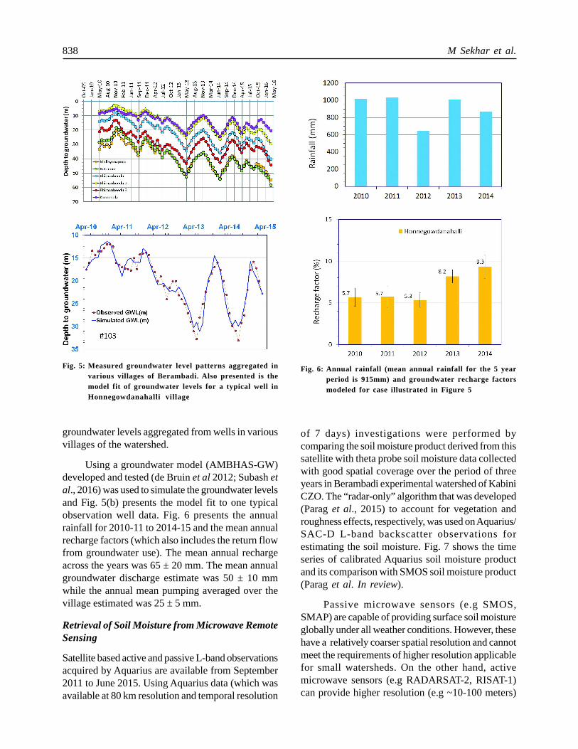
The groundwater levels are monitored in the wells(~200 numbers) of the farmers at a monthlyfrequency since May 2010 in the Berambadiwatershed. Care is taken to obtain the groundwaterlevels unaffected by pumping using the knowledge ofthe electricity provided to these wells, which is often3-4 hours/day. Fig. 5 presents the trends of
Fig. 4: Berambadi instrumented watershed
838 M Sekhar et al.
groundwater levels aggregated from wells in variousvillages of the watershed.
Using a groundwater model (AMBHAS-GW)developed and tested (de Bruin et al 2012; Subash etal., 2016) was used to simulate the groundwater levelsand Fig. 5(b) presents the model fit to one typicalobservation well data. Fig. 6 presents the annualrainfall for 2010-11 to 2014-15 and the mean annualrecharge factors (which also includes the return flowfrom groundwater use). The mean annual rechargeacross the years was 65 ± 20 mm. The mean annualgroundwater discharge estimate was 50 ± 10 mmwhile the annual mean pumping averaged over thevillage estimated was 25 ± 5 mm.
Retrieval of Soil Moisture from Microwave RemoteSensing
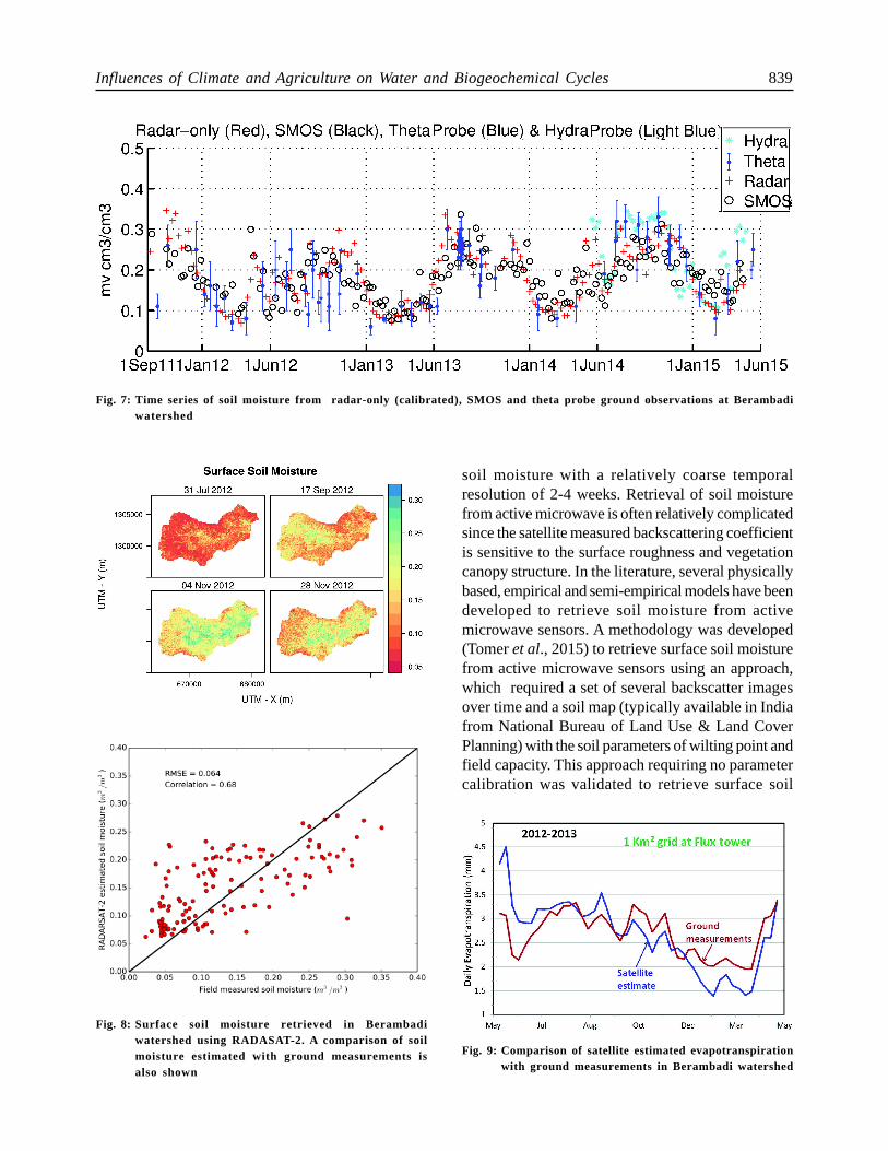
Satellite based active and passive L-band observationsacquired by Aquarius are available from September2011 to June 2015. Using Aquarius data (which wasavailable at 80 km resolution and temporal resolution
of 7 days) investigations were performed bycomparing the soil moisture product derived from thissatellite with theta probe soil moisture data collectedwith good spatial coverage over the period of threeyears in Berambadi experimental watershed of KabiniCZO. The “radar-only” algorithm that was developed(Parag et al., 2015) to account for vegetation androughness effects, respectively, was used on Aquarius/SAC-D L-band backscatter observations forestimating the soil moisture. Fig. 7 shows the timeseries of calibrated Aquarius soil moisture productand its comparison with SMOS soil moisture product(Parag et al. In review).
Passive microwave sensors (e.g SMOS,SMAP) are capable of providing surface soil moistureglobally under all weather conditions. However, thesehave a relatively coarser spatial resolution and cannotmeet the requirements of higher resolution applicablefor small watersheds. On the other hand, activemicrowave sensors (e.g RADARSAT-2, RISAT-1)can provide higher resolution (e.g ~10-100 meters)
Fig. 5: Measured groundwater level patterns aggregated invarious villages of Berambadi. Also presented is themodel fit of groundwater levels for a typical well inHonnegowdanahalli village
Fig. 6: Annual rainfall (mean annual rainfall for the 5 yearperiod is 915mm) and groundwater recharge factorsmodeled for case illustrated in Figure 5
Influences of Climate and Agriculture on Water and Biogeochemical Cycles 839
soil moisture with a relatively coarse temporalresolution of 2-4 weeks. Retrieval of soil moisturefrom active microwave is often relatively complicatedsince the satellite measured backscattering coefficientis sensitive to the surface roughness and vegetationcanopy structure. In the literature, several physicallybased, empirical and semi-empirical models have beendeveloped to retrieve soil moisture from activemicrowave sensors. A methodology was developed(Tomer et al., 2015) to retrieve surface soil moisturefrom active microwave sensors using an approach,which required a set of several backscatter imagesover time and a soil map (typically available in Indiafrom National Bureau of Land Use & Land CoverPlanning) with the soil parameters of wilting point andfield capacity. This approach requiring no parametercalibration was validated to retrieve surface soil
Fig. 7: Time series of soil moisture from radar-only (calibrated), SMOS and theta probe ground observations at Berambadiwatershed
Fig. 8: Surface soil moisture retrieved in Berambadiwatershed using RADASAT-2. A comparison of soilmoisture estimated with ground measurements isalso shown
Fig. 9: Comparison of satellite estimated evapotranspirationwith ground measurements in Berambadi watershed
840 M Sekhar et al.
Fig. 10: Mean daily evapotranspiration for (May-September) estimated from satellite
Influences of Climate and Agriculture on Water and Biogeochemical Cycles 841
moisture using field data collected during 30 campaigns(concurrently with RADARSAT-2 overpass) in 50monitored field plots over a span of four years (2009-2013) in Berambadi watershed. The mean RMSE wasfound to be around 0.04-0.06 m3/m3 and it wasassessed that improved performance and reduced biaswould be feasible with a high resolution soil map.Figure 8 presents the surface soil moisture retrievedat the spatial resolution of 1 hectare for the fourdifferent times during 2012 (a drought year) inBerambadi watershed along with a scatter plotcomparing the retrieved and ground measured soilmoisture in these dates.
Evapotranspiration Estimation Using RemoteSensing Based Models
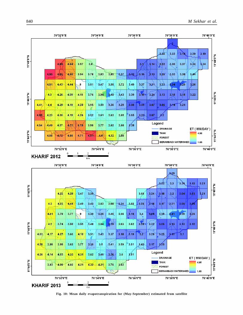
Latent Heat Flux (LHF) or evapotranspiration is acritical component of the hydrologic and energy cyclesbut repeated and consistent estimation of LHF fromground measurements at regional and other largerscales is difficult due to its spatial and temporalvariability. Remote Sensing is the only viable optionto map LHF of relatively large areas periodically, in aglobally consistent and economically feasible manner.Remote sensing based models that are available forthe estimation of LHF can either be complex fullyphysically based land surface schemes or simpleempirical models, which are shown to work withreasonable accuracy for data scarce conditions (Jiangand Islam, 1999). Remote sensing provides only asnapshot of the LHF at the instant of image acquisitionwhereas it is the temporal average (daily/weekly etc.),which is of real interest to various users. Thisconversion is often carried out in various models usingevaporative fraction. Studies were performed tocompare different simple empirical models to estimateLHF using remote sensed data (Eswar et al., 2013,2016). To compare the evapotranspiration estimatedfrom remote sensing, a micrometeorological tower of10 m height developed by the Space ApplicationsCentre of the Indian Space Research Organisationwas installed in the Berambadi watershed. Fig. 9presents evapotranspiration estimated using remotesensing and that from the ground measurements forthe 2012-13. The intra-year trends are capturedresonably with the simple empirical models develped.Using this approach, a evapotranspiration product(2002-2013) is developed with a spatial resolution of1 Km2 and a temporal resolution of 1 week for the
Kabini river basin. Typical spatial patterns of meanevapotranspiration per day for the extended Kharif
Fig. 11: Estimated field capacity of the two soil horizons inthe Berambadi watershed using STICS crop modelinversion. Soil properties of the plots used for thevalidation are also shown
842 M Sekhar et al.
A
B
Influences of Climate and Agriculture on Water and Biogeochemical Cycles 843
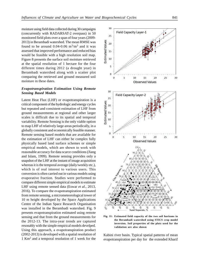
the method in Berambadi by combining with leaf areaindex retrieved using active microwave remote senseddata from RADARSAT-2 (Sreelash et al. in review).Fig. 11 presents the field capacity estimated for thetwo layers with uncertainty estimated obtained fromGLUE in the Berambadi watershed using STICSmodel inversion and LAI retrieved from RADARSAT-2.
Kabini Basin
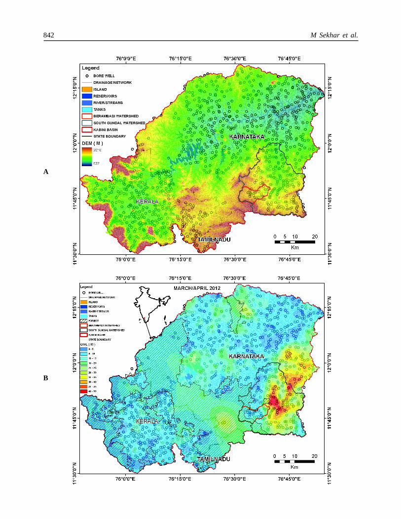
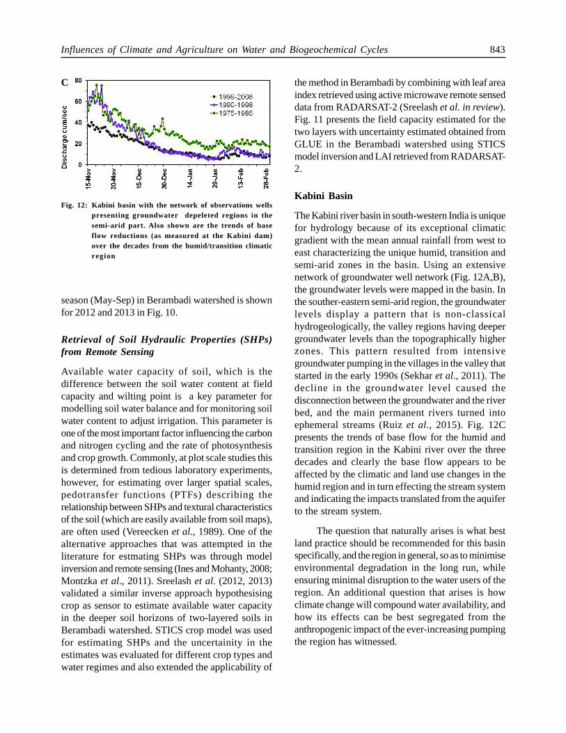
The Kabini river basin in south-western India is uniquefor hydrology because of its exceptional climaticgradient with the mean annual rainfall from west toeast characterizing the unique humid, transition andsemi-arid zones in the basin. Using an extensivenetwork of groundwater well network (Fig. 12A,B),the groundwater levels were mapped in the basin. Inthe souther-eastern semi-arid region, the groundwaterlevels display a pattern that is non-classicalhydrogeologically, the valley regions having deepergroundwater levels than the topographically higherzones. This pattern resulted from intensivegroundwater pumping in the villages in the valley thatstarted in the early 1990s (Sekhar et al., 2011). Thedecline in the groundwater level caused thedisconnection between the groundwater and the riverbed, and the main permanent rivers turned intoephemeral streams (Ruiz et al., 2015). Fig. 12Cpresents the trends of base flow for the humid andtransition region in the Kabini river over the threedecades and clearly the base flow appears to beaffected by the climatic and land use changes in thehumid region and in turn effecting the stream systemand indicating the impacts translated from the aquiferto the stream system.
The question that naturally arises is what bestland practice should be recommended for this basinspecifically, and the region in general, so as to minimiseenvironmental degradation in the long run, whileensuring minimal disruption to the water users of theregion. An additional question that arises is howclimate change will compound water availability, andhow its effects can be best segregated from theanthropogenic impact of the ever-increasing pumpingthe region has witnessed.
Fig. 12: Kabini basin with the network of observations wellspresenting groundwater depeleted regions in thesemi-arid part. Also shown are the trends of baseflow reductions (as measured at the Kabini dam)over the decades from the humid/transition climaticregion
season (May-Sep) in Berambadi watershed is shownfor 2012 and 2013 in Fig. 10.
Retrieval of Soil Hydraulic Properties (SHPs)from Remote Sensing
Available water capacity of soil, which is thedifference between the soil water content at fieldcapacity and wilting point is a key parameter formodelling soil water balance and for monitoring soilwater content to adjust irrigation. This parameter isone of the most important factor influencing the carbonand nitrogen cycling and the rate of photosynthesisand crop growth. Commonly, at plot scale studies thisis determined from tedious laboratory experiments,however, for estimating over larger spatial scales,pedotransfer functions (PTFs) describing therelationship between SHPs and textural characteristicsof the soil (which are easily available from soil maps),are often used (Vereecken et al., 1989). One of thealternative approaches that was attempted in theliterature for estmating SHPs was through modelinversion and remote sensing (Ines and Mohanty, 2008;Montzka et al., 2011). Sreelash et al. (2012, 2013)validated a similar inverse approach hypothesisingcrop as sensor to estimate available water capacityin the deeper soil horizons of two-layered soils inBerambadi watershed. STICS crop model was usedfor estimating SHPs and the uncertainity in theestimates was evaluated for different crop types andwater regimes and also extended the applicability of
C
844 M Sekhar et al.
Acknowledgements
The studies reported here for Kabini CZO werecarried out by several researchers, research scholarsand project staff from both India and France and all
of them are sincerely acknowledged. Funding fromvarious agencies and permission by the KarnatakaForest Department for the above studies isacknowledged.
References
Audry S, Akerman A, Riotte J, Oliva P, Maréchal J C, Fraysse F,
Pokrovsky O and Braun J J (2014) Contribution of forest
fire ash and plant litter decay on stream dissolved
composition in a sub-humid tropical watershed (Mule
Hole, Southern India) Chem Geol 372 144-161
Banwart S A, Chorover J, Gaillardet J, Sparks D, White T,
Anderson S, Aufdenkampe A, Bernasconi S, Brantley S L,
Chadwick O, Dietrich W E, Duffy C, Goldhaber M, Lehnert
K, Nikolaidis N P and Ragnarsdottir K V (2013) Sustaining
Earth’s Critical Zone(http://www.czen.org/sites/default/
f i les/Sustaining-Earths-Cri t ical-Zone_FINAL-
290713.pdf)
Barbiero L, Parate H R, Descloitres M, Bost A, Furian S, Mohan
Kumar M S, Kumar C, Braun J J (2007) Using a structural
approach to identify relationships between soil and erosion
in a semi-humid forested area, South India CATENA 70
313-329
Barbiero L, Mohan Kumar M S, Violette A, Oliva P, Braun J J,
Kumar C, Furian S, Babic M, Riotte J and Valles V (2010)
Soil transformations through ferrolysis induced by recent
natural drainage in Vertisols of 1 sub-humid South India
Geoderma 156 173-188
Braun J J, Descloitres M, Riotte J, Fleury S, Barbiero L, Boeglin
J L, Violette A, Lacarce E, Ruiz L, Sekhar M, Kumar M S
M, Subramanian S and Dupre B (2009) Regolith mass
balance inferred from combined mineralogical, geochemical
and geophysical studies: Mule Hole gneissic watershed,
South India Geochimica and Cosmochmica Acta 73935-
961
Chaudhuri A, Sekhar M, Descloitres M, Godderis Y and Braun J
J (2013) Constraining complex aquifer geometry with
geophysics (2D ERT and MRS measurements) for
stochastic modeling of groundwater flow Jour Applied
Geophysics 98 288-297
de Bruin A, de Condappa D, Mikhail M, Tomer S K, Sekhar M
and Barron J (2012) Simulated water resource impacts and
livelihood implications of stakeholder developed scenarios
in the Jaldhaka basin India Water International 37 492-508
Descloitres M, Ruiz L, Sekhar M, Legchenko A, Braun J J, Kumar
M S M and Subramanian S (2008) Characterization of
seasonal local recharge using electrical resistivity
tomography and magnetic resonance sounding
Hydrological Processes 22 384-394
Eswar R, Sekhar M and Bhattacharya B K (2013) A simple
model for spatial disaggregation of evaporative fraction-
Comparative study with thermal sharpened land surface
temperature data over India Journal of Geophysical
Research - Atmospheres 118 029-044
Eswar R, Sekhar M and Bhattacharya B K (2016) Disaggregation
of LST over India: Comparative analysis of different
vegetation indices International Journal of Remote Sensing
(In Press) (http://dx.doi.org/10.1080/01431161.2016.
1145363)
Ines A V M and Mohanty B P (2008) Near-surface soil moisture
assimilation for quantifying effective soil hydraulic
properties under different hydro-climatic conditions
Vadose Zone J 7 39-52 (doi: 10.2136/vzj2007.0048)
Jouquet P, Guilleux N, Caner L, Chintakunta S, Ameline M and
Shanbhag R (2015a) Influence of soil pedological properties
on termite mound stability Geoderma 262 45-51
Jouquet P, Guilleux N, Shanbhag R R and Subramanian S (2015b)
Influence of soil type on the properties of termite mound
nests in Southern India Applied Soil Ecology 96 282-287
Jouquet P, Guilleux N, Chintakunta, S, Mendez M and Shanbhag
R R (2015c) The influence of termites on soil sheeting
properties varies depending on the materials on which
they feed Eur J Soil Biol 69 74-78
Jouquet P, Chintakunta S, Bottinelli N, Subramanian S and Caner
L (2016) The influence of termites on soil macro- and
micro-aggregates varies with soil properties Applied Soil
Ecology 101 117-123
Jiang L and S Islam (1999) A methodology for estimation of
surface evapotranspiration over large areas using remote
sensing observations Geophysical Research Letters 26
2773-2776
Legchenko A, Descloitres, M, Bost A, Ruiz L, Reddy M, Girard
Influences of Climate and Agriculture on Water and Biogeochemical Cycles 845
J F, Sekhar M, Mohan Kumar M S and Braun J J (2006)
Efficiency of Magnetic Resonance Soundings applied to
characterization of anisotropic crystalline basement
aquifers Groundwater 44 547-554
Marechal J C, Varma M R R, Riotte J, Vouillamoz J M, Kumar M
S M, Ruiz L, Sekhar M and Braun J J (2009) Indirect and
direct recharges in a tropical forested watershed: Mule
Hole, India Journal of Hydrology 364 272-284
Marechal J C, Riotte J, Lagane C, Subramanian S, Kumar C, Ruiz
L, Audry S, Murari V and Braun J J (2011) Chemical
groundwater outputs from a small drainage watershed:
Mule Hole, South India Appl Geochem 26 S94-S96
Montzka C, Moradkhani H, Weihermuller L, Franssen H H,
Canty M and Vereecken H (2011) Hydraulic parameter
estimation by remotely-sensed top soil moisture
observations with the particle filter Journal of Hydrology
399 410-421 (doi: 10.1016/j.jhydrol.2011.01.020)
Narvekar P S, Entekhabi D, Kim S and Njoku E (2015) Soil
moisture retrievalusing L-band radar observations IEEE
Trans Geosci Remote Sensing 533492-3506
Narvekar P S, Sekhar M, Tomer S K, Das N, Entekhabi D and Le
Vine D Evaluation of Aquarius radar soil moisture estimates
and comparison with radiometer products In review with
IEEE Trans Geosci Remote Sensing NRC (2001) National
Research Council committee on Basic Research
Opportunities in the Earth Sciences, Basic Research
Opportunities in the Earth Sciences, National Academies
Press, Washington, DC, 2001
Parate H R, Mohan Kumar M S, Descloitres M, Barbiero L, Ruiz
L, Braun J J, Sekhar M and Kumar C (2011) Comparison
of electrical resistivity by geophysical method and neutron
probe logging for soil moisture monitoring in forested
watershed Current Science 100 1405-1412
Riotte J, Marechal J C, Audry S, Kumar C, Bedimo J P, Ruiz L,
Sekhar M, Varma M R R, Lagane C and Braun J J (2014)
Vegetation impact on stream chemical fluxes: Mule Hole
watershed (South India) Geochimica and Cosmochmica
Acta 145 116-138
Riotte J, Ruiz L, Audry S, Sekhar M, Mohan Kumar M S, Siva
Soumya B and Braun J J (2015) Impact of vegetation and
decennial rainfall fluctuations on the weathering fluxes
exported from a dry tropical forest (Mule Hole) Procedia
Earth and Planetary Science 10 34-37
Ruiz L, Murari R R V, Mohan Kumar M S, Sekhar M, Maréchal
J C, Descloitres M, Riotte J, Sat Kumar Kumar C and
Braun J J (2009) Water balance modelling in a tropical
watershed under deciduous forest (Mule Hole, India) :
Regolith matric storage buffers the groundwater recharge
process Journal of Hydrology 380460-472
Ruiz L, Sekhar M, Thomas A, Badiger S, Bergez J E, Buis S,
Corgne S, Riotte J, Raynal H, Bandyopadhyay S and
Gascule C (2015) Adaptation of irrigated agriculture to
climate change: trans-disciplinary modelling of a watershed
in South India. Hydrological Sciences and Water Security:
Past, Present and Future. Proceedings of the 11th Kovacs
Colloquium, Paris, France, June 2014. IAHS Publ 366
2015 (doi: 10.5194/piahs-366-137-2015)
Sekhar M, Javeed Y, Bandyopadhyay S, Mangiarotti S and
Mazzega P (2011) Groundwater management practices
and emerging challenges: Lessons from a case study in the
Karnataka State of South India. In: IAHR Monograph on
Groundwater Management Practices (eds.) Findkakis A N
and K Sato Chapter 5, CRC Press, ISBN 10: 0415619874
Siva Soumya B, Sekhar M, Riotte J, Audry S, Lagane C and
Braun J J (2011) Inverse models to analyze the
spatiotemporal variations of chemical weathering fluxes in
a granito-gneissic watershed: Mule Hole, South India
Geoderma 165 12-24
Sreelash K, Sekhar M, Ruiz L, Sat Kumar Guérif M, Buis S,
Durand P and Gascuel-Odoux C (2012) Parameter
estimation of a two-horizon soil profile by combining crop
canopy and surface soil moisture observations using GLUE
Journal of Hydrology 456-457 57-67
Sreelash K, Sekhar M, Ruiz L, Buis S and Bandyopadhyay S
(2013) Improved modeling of groundwater recharge in
agricultural watersheds using a combination of crop model
and remote sensing Special Issue of Journal of Indian
Institute of Science 93 189-207
Subash Y, Sekhar M, Tomer S K, Sharma A K A framework for
assessment of climate change impacts on the groundwater
system (In: Sustainable Water Resources Management,
Editors: C S P Ojha, S Rao, T Zhang and A Bardossy).
Chapter 14, ASCE Book Chapter. (In Press)
Tomer S K, Al Bitar A, Sekhar M, Corgne S, Bandyopadhyay S,
Sreelash K, Sharma A K, Zribi M and Kerr Y (2015)
Retrieval and multi-scale validation of soil moisture from
multi-temporal SAR data in a tropical region Remote
Sensing 7 8128-8153
Vereecken H, Maes J, Feyen J and Darius P (1989) Deriving
pedotransfer functions of soil hydraulic properties In: ISSS
symposium, Wageningen, pp 121-124
Vimal Singh (2015) The Indian critical zone – a case for priority
studies Current Science 108 1-2

846 M Sekhar et al.
Violette A, Goddéris G, Maréchal J M, Riotte J, Oliva P, Mohan
Kumar M S, Sekhar M and Braun J J (2010a) Modelling
the chemical weathering fluxes at the watershed scale in
the Tropics (Mule Hole, South India): Relative contribution
of the smectite/kaolinite assemblage versus primary
minerals Chem Geol 277 42-60
Violette A, Riotte J, Braun J J, Oliva P, Maréchal J C, Sekhar M,
Jeandel C, Subramanian S, Barbiero L and Dupré B (2010b)
Formation and preservation of pedogenic carbonates in
South India, links with paleomonsoon and pedological
conditions: Clues from Sr isotopes, U-Th series and REEs
Geochim Cosmochim Acta 74 7059-7085.