Embed Size (px)
DESCRIPTION
Industrial Estate. The Ruhrgebiet 1. - PowerPoint PPT Presentation
Citation preview
CHAPTER 3 – CASE STUDIES PAGE 1
Industrial Estate
The Ruhrgebiet 1
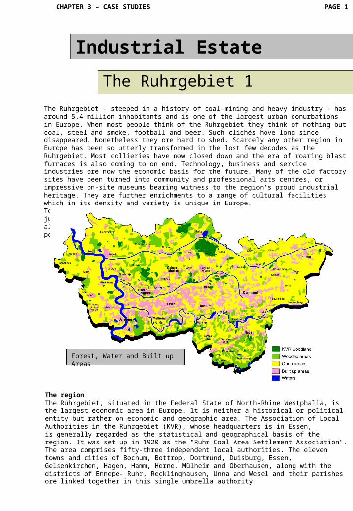
The Ruhrgebiet ‑ steeped in a history of coal‑mining and heavy industry ‑ has around 5.4 million inhabitants and is one of the largest urban conurbations in Europe. When most people think of the Ruhrgebiet they think of nothing but coal, steel and smoke, football and beer. Such clichés hove long since disappeared. Nonetheless they ore hard to shed. Scarcely any other region in Europe has been so utterly transformed in the lost few decodes as the Ruhrgebiet. Most collieries have now closed down and the era of roaring blast furnaces is also coming to on end. Technology, business and service industries ore now the economic basis for the future. Many of the old factory sites have been turned into community and professional arts centres, or impressive on‑site museums bearing witness to the region's proud industrial heritage. They are further enrichments to a range of cultural facilities which in its density and variety is unique in Europe. Today the Ruhrgebiet is a landscape full of contrasts resulting from the juxtaposition of a tangible industrial post and a vibrant present. This has always been a dynamic region with proud traditions and forward‑looking perspectives.
The regionThe Ruhrgebiet, situated in the Federal State of North‑Rhine Westphalia, is the largest economic area in Europe. lt is neither a historical or political entity but rather on economic and geographic area. The Association of Local Authorities in the Ruhrgebiet (KVR), whose headquarters is in Essen, is generally regarded as the statistical and geographical basis of the region. It was set up in 1920 as the "Ruhr Coal Area Settlement Association". The area comprises fifty‑three independent local authorities. The eleven towns and cities of Bochum, Bottrop, Dortmund, Duisburg, Essen, Gelsenkirchen, Hagen, Hamm, Herne, Mülheim and Oberhausen, along with the districts of Ennepe- Ruhr, Recklinghausen, Unna and Wesel and their parishes ore linked together in this single umbrella authority.
Forest, Water and Built up Areas
CHAPTER 3 – CASE STUDIES PAGE 2
Industrial Estate
The Ruhrgebiet 2
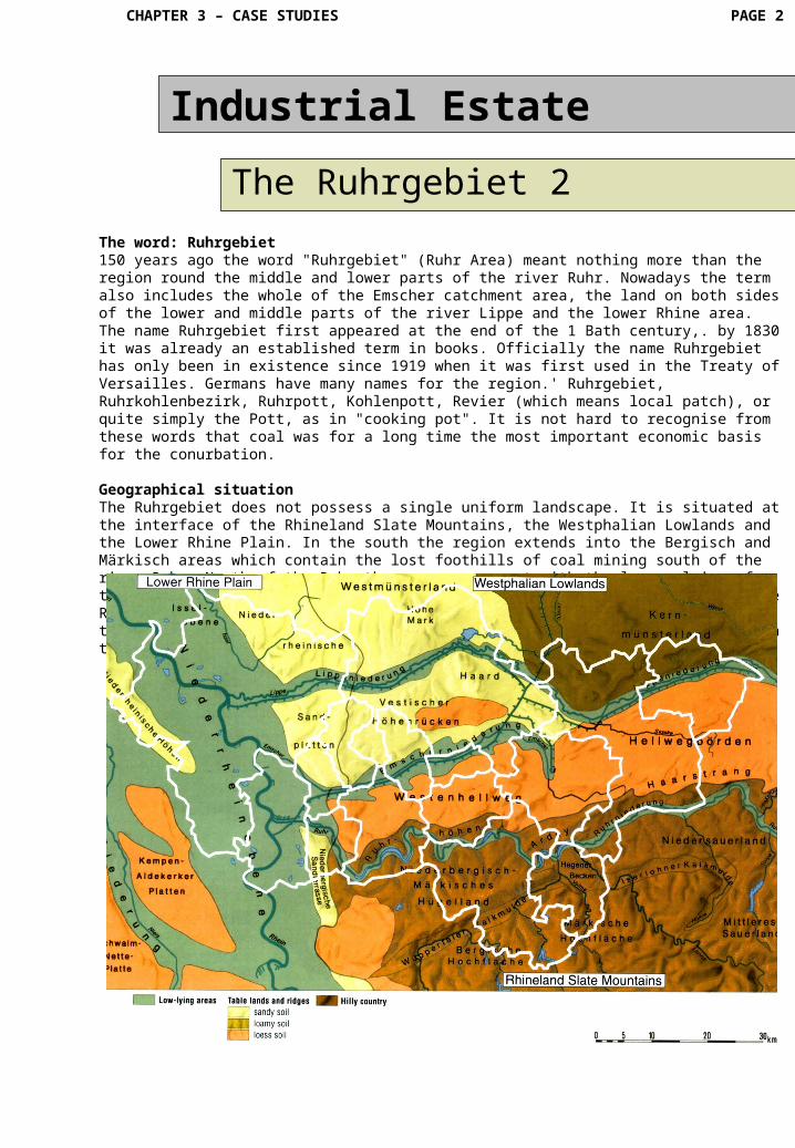
The word: Ruhrgebiet150 years ago the word "Ruhrgebiet" (Ruhr Area) meant nothing more than the region round the middle and lower parts of the river Ruhr. Nowadays the term also includes the whole of the Emscher catchment area, the land on both sides of the lower and middle parts of the river Lippe and the lower Rhine area. The name Ruhrgebiet first appeared at the end of the 1 Bath century,. by 1830 it was already an established term in books. Officially the name Ruhrgebiet has only been in existence since 1919 when it was first used in the Treaty of Versailles. Germans have many names for the region.' Ruhrgebiet, Ruhrkohlenbezirk, Ruhrpott, Kohlenpott, Revier (which means local patch), or quite simply the Pott, as in "cooking pot". It is not hard to recognise from these words that coal was for a long time the most important economic basis for the conurbation.
Geographical situationThe Ruhrgebiet does not possess a single uniform landscape. It is situated at the interface of the Rhineland Slate Mountains, the Westphalian Lowlands and the Lower Rhine Plain. In the south the region extends into the Bergisch and Märkisch areas which contain the lost foothills of coal mining south of the river Ruhr. North of the Ruhr these areas connect with the loess plains of the Hellweg zone and the Emscher valley. In the north of the Lippe volley the Ruhrgebiet runs into the Münsterland area. The region is bordered by Hamm in the north‑east, Wesel (the district of Wesel) in the north‑west, Duisburg in the south‑west and Hagen in the south‑east.
CHAPTER 3 – CASE STUDIES PAGE 3
Industrial Estate
The Ruhrgebiet 3
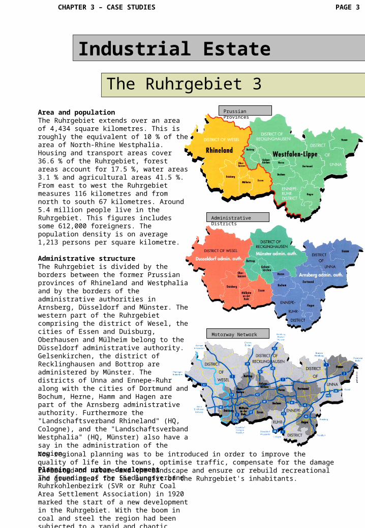
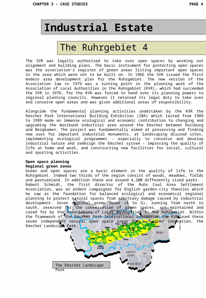
Area and populationThe Ruhrgebiet extends over an area of 4,434 square kilometres. This is roughly the equivalent of 10 % of the area of North‑Rhine Westphalia. Housing and transport areas cover 36.6 % of the Ruhrgebiet, forest areas account for 17.5 %, water areas 3.1 % and agricultural areas 41.5 %. From east to west the Ruhrgebiet measures 116 kilometres and from north to south 67 kilometres. Around 5.4 million people live in the Ruhrgebiet. This figures includes some 612,000 foreigners. The population density is on average 1,213 persons per square kilometre. Administrative structureThe Ruhrgebiet is divided by the borders between the former Prussian provinces of Rhineland and Westphalia and by the borders of the administrative authorities in Arnsberg, Düsseldorf and Münster. The western part of the Ruhrgebiet comprising the district of Wesel, the cities of Essen and Duisburg, Oberhausen and Mülheim belong to the Düsseldorf administrative authority. Gelsenkirchen, the district of Recklinghausen and Bottrop are administered by Münster. The districts of Unna and Ennepe‑Ruhr along with the cities of Dortmund and Bochum, Herne, Hamm and Hagen are part of the Arnsberg administrative authority. Furthermore the "Landschaftsverband Rhineland" (HQ, Cologne), and the "Landschaftsverband Westphalia" (HQ, Münster) also have a say in the administration of the region.
Planning and urban developmentThe founding of the Siedlungsverband Ruhrkohlenbezirk (SVR or Ruhr Coal Area Settlement Association) in 1920 marked the start of a new development in the Ruhrgebiet. With the boom in coal and steel the region had been subjected to a rapid and chaotic period of building, primarily to house or rehouse workers pouring into the area.
Prussian Provinces
Now regional planning was to be introduced in order to improve the quality of life in the towns, optimise traffic, compensate for the damage inflicted on nature and the landscape and ensure or rebuild recreational and green areas for the benefit of the Ruhrgebiet's inhabitants.
Administrative Districts
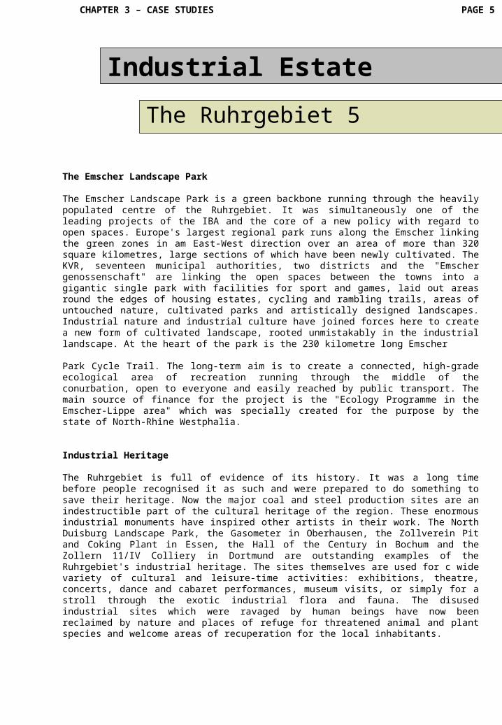
Motorway Network
CHAPTER 3 – CASE STUDIES PAGE 4
Industrial Estate
The Ruhrgebiet 4The SVR was legally authorised to take over open spaces by working out alignment and building plans. The basic instrument for protecting open spaces was the association's register of green areas listing important open spaces in the area which were not to be built on. In 1966 the SVR issued the first modern area development plan for the Ruhrgebiet. The new version of the Association law in 1979 was a turning point in the planning work of the Association of Local Authorities in the Ruhrgebiet (KVR), which had succeeded the SVR in 1976, for the KVR was forced to hand over its planning powers to regional planning councils. However it retained its legal duty to take over and conserve open areas and was given additional areas of responsibility. Alongside the fundamental planning activities undertaken by the KVR the Emscher Park International Building Exhibition (IBA) which lasted from 1989 to 1999 mode an immense ecological and economic contribution to changing and upgrading the moribund industrial area around the Emscher between Duisburg and Bergkamen. The project was fundamentally aimed at preserving and finding new uses for important industrial monuments, at landscaping disused sites, implementing ecological programmes ‑ especially to conserve and develop industrial nature and redesign the Emscher system ‑ improving the quality of life at home and work, and constructing new facilities for social, cultural and sporting activities.
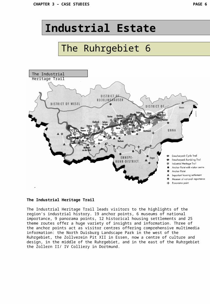
Open space planningRegional green zonesGreen and open spaces are a basic element in the quality of life in the Ruhrgebiet. Indeed two thirds of the region consist of woods, meadows, fields and pastureland. In addition there are around 4,200 differently sized parks.Robert Schmidt, the first director of the Ruhr Coal Area Settlement Association, was an ardent campaigner for English garden‑city theories which he saw as the foundation for balanced ecological and economical regional planning to protect natural spaces from arbitrary damage caused by industrial development. Seven regional green zones (A to G), running from north to south, reserved for the conservation of green spaces, are maintained and cared for by the Association of Local Authorities in the Ruhrgebiet. Within the framework of the Emscher Pork International Exhibition the KVR used these seven independent natural open space areas for a further innovation, the Emscher Landscape Park.
The Emscher Landscape Park
CHAPTER 3 – CASE STUDIES PAGE 5
Industrial Estate
The Ruhrgebiet 5
The Emscher Landscape Park
The Emscher Landscape Park is a green backbone running through the heavily populated centre of the Ruhrgebiet. It was simultaneously one of the leading projects of the IBA and the core of a new policy with regard to open spaces. Europe's largest regional park runs along the Emscher linking the green zones in am East‑West direction over an area of more than 320 square kilometres, large sections of which have been newly cultivated. The KVR, seventeen municipal authorities, two districts and the "Emscher genossenschaft" are linking the open spaces between the towns into a gigantic single park with facilities for sport and games, laid out areas round the edges of housing estates, cycling and rambling trails, areas of untouched nature, cultivated parks and artistically designed landscapes. Industrial nature and industrial culture have joined forces here to create a new form of cultivated landscape, rooted unmistakably in the industrial landscape. At the heart of the park is the 230 kilometre long Emscher Park Cycle Trail. The long‑term aim is to create a connected, high-grade ecological area of recreation running through the middle of the conurbation, open to everyone and easily reached by public transport. The main source of finance for the project is the "Ecology Programme in the Emscher‑Lippe area" which was specially created for the purpose by the state of North‑Rhine Westphalia.
Industrial Heritage
The Ruhrgebiet is full of evidence of its history. It was a long time before people recognised it as such and were prepared to do some thing to save their heritage. Now the major coal and steel production sites are an indestructible part of the cul tural heritage of the region. These enormous industrial monuments have inspired other artists in their work. The North Duisburg Landscape Park, the Gasometer in Oberhausen, the Zollverein Pit and Coking Plant in Essen, the Hall of the Century in Bochum and the Zollern 11/IV Col liery in Dortmund are outstanding ex amples of the Ruhrgebiet's industrial heritage. The sites themselves are used for c wide variety of cultural and leisure‑time activities: exhibi tions, theatre, concerts, dance and cabaret performances, museum vis its, or simply for a stroll through the exotic industrial flora and fauna. The disused industrial sites which were ravaged by human beings have now been reclaimed by nature and places of refuge for threatened animal and plant species and welcome areas of recuperation for the local inhabitants.
CHAPTER 3 – CASE STUDIES PAGE 6
Industrial Estate
The Ruhrgebiet 6
The Industrial Heritage Trail
The Industrial Heritage Trail leads visitors to the highlights of the region's industrial history. 19 anchor points, 6 museums of national importance, 9 panorama points, 12 historical housing settlements and 25 theme routes offer a huge variety of insights and information. Three of the anchor points act as visitor centres offering comprehensive multimedia information: the North Duisburg Landscape Park in the west of the Ruhrgebiet, the Zollverein Pit XII in Essen, now a centre of culture and design, in the middle of the Ruhrgebiet, and in the east of the Ruhrgebiet the Zollern II/ IV Colliery in Dortmund.
The Industrial Heritage Trail