Embed Size (px)
Citation preview
Index No.:_____________________ SEC15/1.14m
© The MATSEC Examinations Board reserves all rights on the examination questions in all examination papers set by the said Board.
MATRICULATION AND SECONDARY EDUCATION CERTIFICATE EXAMINATIONS BOARDUNIVERSITY OF MALTA, MSIDA
SECONDARY EDUCATION CERTIFICATE LEVEL
MAY 2014 SESSION
SUBJECT: GeographyPAPER NUMBER: IDATE: 5th May 2014TIME: 9:00 a.m. to 11:00 a.m.
Answer ALL questions
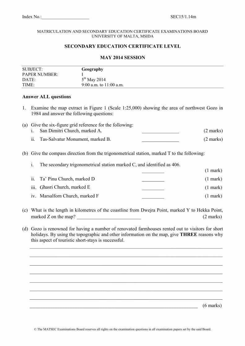
1. Examine the map extract in Figure 1 (Scale 1:25,000) showing the area of northwest Gozo in1984 and answer the following questions:
(a) Give the six-figure grid reference for the following:i. San Dimitri Church, marked A. _______________ (2 marks)
ii. Tas-Salvatur Monument, marked B. _______________ (2 marks)
(b) Give the compass direction from the trigonometrical station, marked T to the following:
i. The secondary trigonometrical station marked C, and identified as 406._________ (1 mark)
ii. Ta’ Pinu Church, marked D _________ (1 mark)
iii. Għasri Church, marked E _________ (1 mark)
iv. Marsalforn Church, marked F _________ (1 mark)
(c) What is the length in kilometres of the coastline from Dwejra Point, marked Y to Hekka Point,marked Z on the map? __________________________ (2 marks)
(d) Gozo is renowned for having a number of renovated farmhouses rented out to visitors for shortholidays. By using the topographic and other information on the map, give THREE reasons whythis aspect of touristic short-stays is successful.
______________________________________________________________________________
______________________________________________________________________________
______________________________________________________________________________
______________________________________________________________________________
______________________________________________________________________________
______________________________________________________________________________
______________________________________________________________________________
____________________________________________________________________ (6 marks)

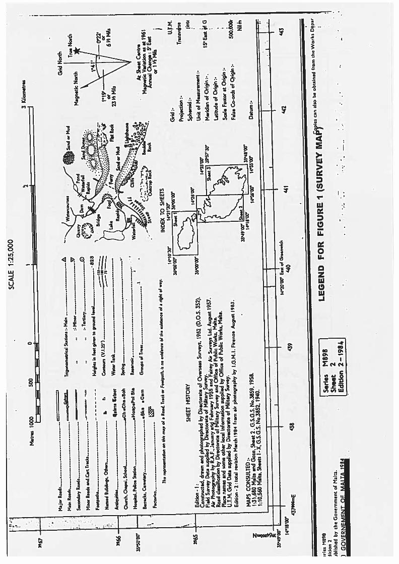

SEC15/1.14mDO NOT WRITE ABOVE THIS LINE
Page 5 of 11
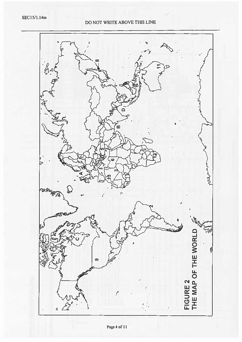
2. Study the world map (Figure 2) and then answer the following questions.
(a) Match the following descriptions with locations marked on the map and numbered 1 to 3.
Description Number and Name of Location
A major desert
A major ocean current
A major port
(3 marks)(b) Name the seas marked A to D.
A _________________ B _________________
C _________________ D _________________(2 marks)
(c) Name the countries and their capital cities marked by the numbers 5 to 8.
5 ________________ _________________ 6 ________________ _________________
7 ________________ _________________ 8 ________________ _________________
(6 marks)
(d) Name the mountain systems numbered 9 to 13.
9 _____________________ 10 _____________________
11 _____________________ 12 _____________________
13 _____________________ (5 marks)

SEC15/1.14mDO NOT WRITE ABOVE THIS LINE
Page 6 of 11
3.
Figure 3: An area suffering from soil erosionAdapted from OGP 3 Contrasts in Development
(a) Study the sketch in figure 3 and, on the grid below, match the correct number indicated with thedescription of the evident cause of erosion.
Overgrazing
Monoculture
Open to strong winds
Gullies into the soil
Up and down ploughing
Deforestation
River banks crumbling
(2 marks)
SEC15/1.14mDO NOT WRITE ABOVE THIS LINE
Page 7 of 11
(b) Choose TWO of the above causes of erosion and briefly explain how these can be controlled byhuman activity.
i) __________________________________________________________________________
__________________________________________________________________________
__________________________________________________________________________
ii) __________________________________________________________________________
_________________________________________________________________________________
________________________________________________________________________ (4 marks)
4.(a) Name TWO factors that cause deposition of materials in glaciated environments.
_____________________________________________________________________________
_____________________________________________________________________________
_____________________________________________________________________(2 marks)
(b) What is an erratic in a glaciated environment?_____________________________________________________________________________
_____________________________________________________________________ (2 marks)
(c) How is a drumlin formed?
____________________________________________________________________________
_____________________________________________________________________________
_____________________________________________________________________ (3 marks)
5.(a) Name THREE types of farming that are responsible for deforestation in the Amazon rainforest.
(i) _________________________________________________________________________
(ii) _________________________________________________________________________
(iii) _________________________________________________________________ (3 marks)
SEC15/1.14mDO NOT WRITE ABOVE THIS LINE
Page 8 of 11
(b) Briefly describe the main characteristics of ONE type of farming mentioned above._____________________________________________________________________________
_____________________________________________________________________________
_____________________________________________________________________________
_____________________________________________________________________________
_____________________________________________________________________ (2 marks)
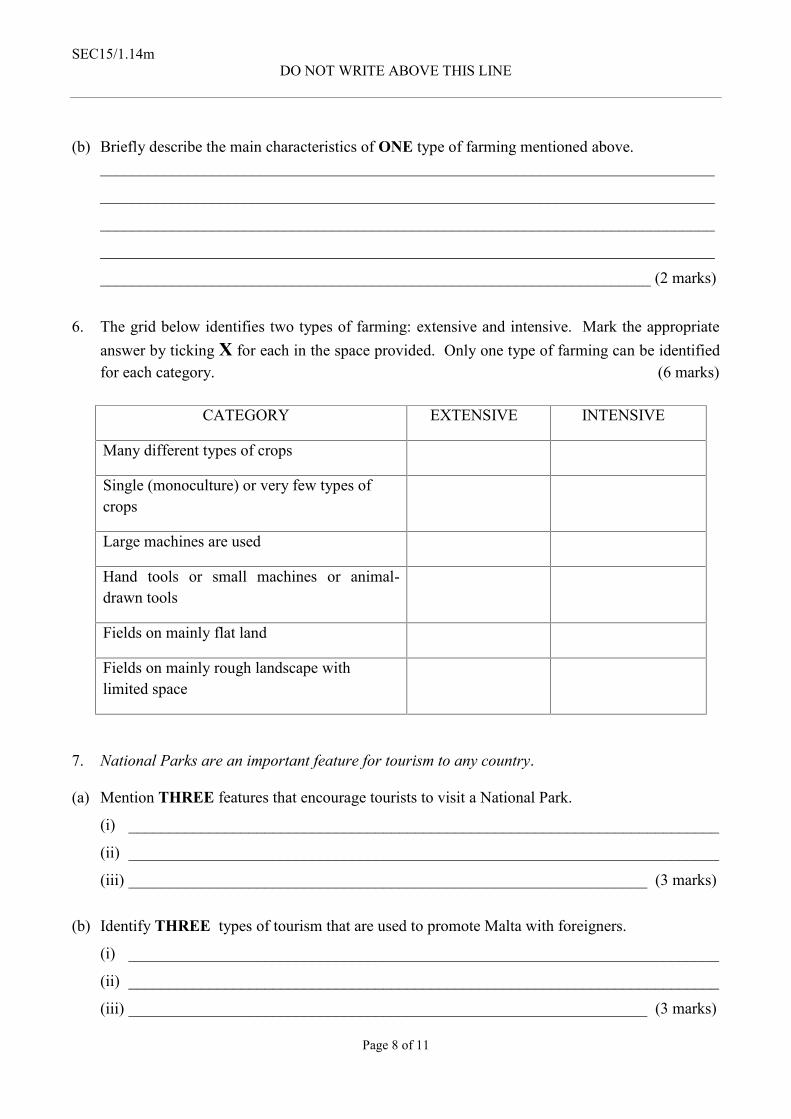
6. The grid below identifies two types of farming: extensive and intensive. Mark the appropriateanswer by ticking X for each in the space provided. Only one type of farming can be identifiedfor each category. (6 marks)
CATEGORY EXTENSIVE INTENSIVE
Many different types of crops
Single (monoculture) or very few types ofcrops
Large machines are used
Hand tools or small machines or animal-drawn tools
Fields on mainly flat land
Fields on mainly rough landscape withlimited space
7. National Parks are an important feature for tourism to any country.
(a) Mention THREE features that encourage tourists to visit a National Park.
(i) __________________________________________________________________________
(ii) __________________________________________________________________________
(iii) _________________________________________________________________ (3 marks)
(b) Identify THREE types of tourism that are used to promote Malta with foreigners.
(i) __________________________________________________________________________
(ii) __________________________________________________________________________
(iii) _________________________________________________________________ (3 marks)
SEC15/1.14mDO NOT WRITE ABOVE THIS LINE
Page 9 of 11
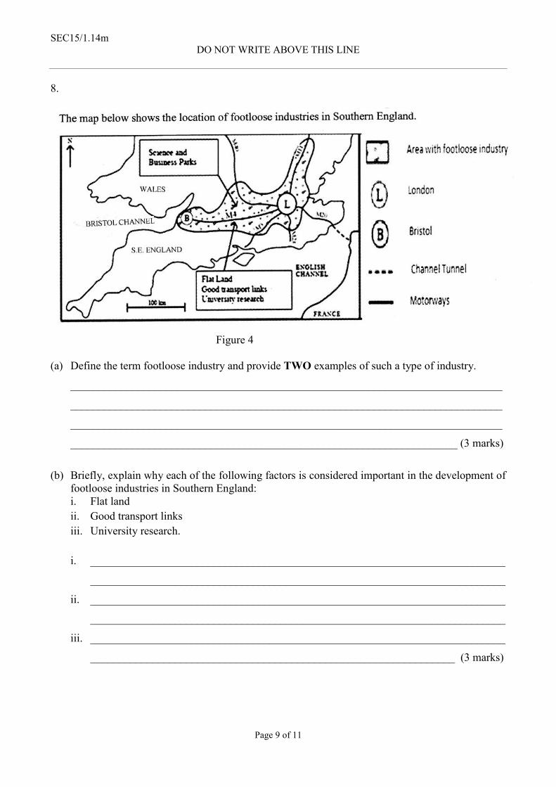
8.
Figure 4
(a) Define the term footloose industry and provide TWO examples of such a type of industry.
_____________________________________________________________________________
_____________________________________________________________________________
_____________________________________________________________________________
_____________________________________________________________________ (3 marks)
(b) Briefly, explain why each of the following factors is considered important in the development offootloose industries in Southern England:i. Flat landii. Good transport linksiii. University research.
i. __________________________________________________________________________
__________________________________________________________________________
ii. __________________________________________________________________________
__________________________________________________________________________
iii. __________________________________________________________________________
_________________________________________________________________ (3 marks)
SEC15/1.14mDO NOT WRITE ABOVE THIS LINE
Page 10 of 11
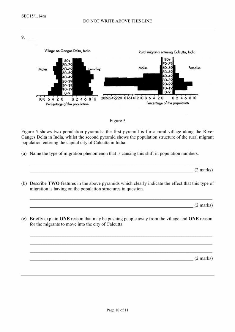
9.
Figure 5
Figure 5 shows two population pyramids: the first pyramid is for a rural village along the RiverGanges Delta in India, whilst the second pyramid shows the population structure of the rural migrantpopulation entering the capital city of Calcutta in India.
(a) Name the type of migration phenomenon that is causing this shift in population numbers.
_____________________________________________________________________________
_____________________________________________________________________ (2 marks)
(b) Describe TWO features in the above pyramids which clearly indicate the effect that this type ofmigration is having on the population structures in question.
_____________________________________________________________________________
_____________________________________________________________________ (2 marks)
(c) Briefly explain ONE reason that may be pushing people away from the village and ONE reasonfor the migrants to move into the city of Calcutta.
_____________________________________________________________________________
_____________________________________________________________________________
_____________________________________________________________________________
_____________________________________________________________________ (2 marks)

SEC15/1.14mDO NOT WRITE ABOVE THIS LINE
Page 11 of 11
10. Figure 6 is a simplified diagram showing the main causes of global warming.
Figure 6
(a) Match the statements below with the annotated boxes A, B and C displayed in Figure 6:
i. More outgoing heat trapped
ii. Increased greenhouse gases
iii. Incoming radiation from the sun
(3 marks)
(b) Describe the main causes of global warming as displayed in Figure 6.
_____________________________________________________________________________
_____________________________________________________________________________
_____________________________________________________________________________
_____________________________________________________________________________
_____________________________________________________________________________
_____________________________________________________________________________
_____________________________________________________________________________
____________________________________________________________________ (3 marks)

SEC15/2A.14m
© The MATSEC Examinations Board reserves all rights on the examination questions in all examination papers set by the said Board.
MATRICULATION AND SECONDARY EDUCATION CERTIFICATE EXAMINATIONS BOARDUNIVERSITY OF MALTA, MSIDA
SECONDARY EDUCATION CERTIFICATE LEVEL
MAY 2014 SESSION
SUBJECT: GeographyPAPER NUMBER: IIADATE: 6th May 2014TIME: 9:00 a.m. to 11:00 a.m.
Answer any two (2) Questions from Section A and any other two (2) questions from Section B.
ANSWER FOUR QUESTIONS IN TOTAL
Answers are to be written on the booklet provided.
Each question carries a total of 25 marks. Marks allocated to parts of questions are indicated.
Good use of language and orderly presentation are important. Credit will be given for relevantillustrations.
The use of non-programmable calculators and geometric instruments is permitted.
SECTION A: Answer two (2) questions from this Section.
1.
Figure 1: Structure of the Earth
(a) With the help of Figure 1, define the physical characteristics of the following two layers: Inner core Outer core (6 marks)
(b) Explain how the convection currents within the mantle operate. (10 marks)(c) In what ways do the currents within the mantle affect the overlying tectonic plates that make
up the crust layer? (9 marks)
SEC15/2A.14m
Page 2 of 3
2.
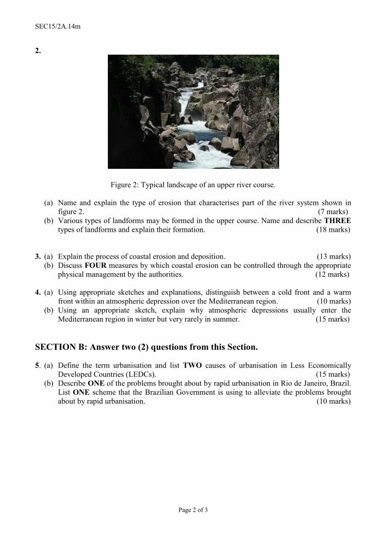
Figure 2: Typical landscape of an upper river course.
(a) Name and explain the type of erosion that characterises part of the river system shown infigure 2. (7 marks)
(b) Various types of landforms may be formed in the upper course. Name and describe THREEtypes of landforms and explain their formation. (18 marks)
3. (a) Explain the process of coastal erosion and deposition. (13 marks)(b) Discuss FOUR measures by which coastal erosion can be controlled through the appropriate
physical management by the authorities. (12 marks)
4. (a) Using appropriate sketches and explanations, distinguish between a cold front and a warmfront within an atmospheric depression over the Mediterranean region. (10 marks)
(b) Using an appropriate sketch, explain why atmospheric depressions usually enter theMediterranean region in winter but very rarely in summer. (15 marks)
SECTION B: Answer two (2) questions from this Section.
5. (a) Define the term urbanisation and list TWO causes of urbanisation in Less EconomicallyDeveloped Countries (LEDCs). (15 marks)
(b) Describe ONE of the problems brought about by rapid urbanisation in Rio de Janeiro, Brazil.List ONE scheme that the Brazilian Government is using to alleviate the problems broughtabout by rapid urbanisation. (10 marks)

SEC15/2A.14m
Page 3 of 3
6. Figure 3 below shows a map of the M4 Corridor near London, UK which represents the hub forHigh Technology Industries.
Figure 3: Source: The Telegraph 3rd November 2010.
(a) Define the term high technology industries and give TWO examples of such industries.(10 marks)
(b) Using the example from the M4 Corridor in the UK, explain FIVE factors that affect thedevelopment of high technology industries in particular locations. (15 marks)
7. In order to produce more and better food and ensure reliable supplies from the land, a number offarming practices are used all over the world. However, not all methods are favourable to theenvironment. The use of fertilisers intended to add nutrients to the soil and the removal ofhedgerows (as rubble walls in Malta) to join small fields into larger ones are actions which alsobring with them negative impacts.(a) Describe the negative effects of the use of artificial fertilisers on the environment. (5 marks)(b) What are the advantages of having hedgerows (or rubble walls) on farmland? (10 marks)(c) Name and explain TWO farming practices, which produce better agricultural products.
(10 marks)
8. (a) What are the THREE main indicators that are used by the United Nations to establish theHuman Development Index (HDI) of different nations? (6 marks)
(b) How can governments improve upon the selected indicators to ensure a better quality of lifefor their population? (15 marks)
(c) Give TWO reasons that bring about differences in the HDI within the same country?(4 marks)

SEC15/2B.14m
© The MATSEC Examinations Board reserves all rights on the examination questions in all examination papers set by the said Board.
MATRICULATION AND SECONDARY EDUCATION CERTIFICATE EXAMINATIONS BOARDUNIVERSITY OF MALTA, MSIDA
SECONDARY EDUCATION CERTIFICATE LEVEL
MAY 2014 SESSION
SUBJECT: GeographyPAPER NUMBER: IIBDATE: 6th May 2014TIME: 9:00 a.m. to 11:00 a.m.
Answer any two (2) Questions from Section A and any other two (2) questions from Section B.
ANSWER FOUR QUESTIONS IN ALL
Answers are to be written on the booklet provided.
Each question carries a total of 25 marks. Marks allocated to parts of questions are indicated.
Good use of language and orderly presentation are important. Credit will be given for relevantillustrations.
The use of non-programmable calculators and geometric instruments is permitted.
SECTION A: Answer TWO (2) questions from this Section.
1.
Figure 1

SEC15/2B.14m
Page 2 of 3
Figure 1 shows the distribution of fatal earthquakes in 2011 and the number of people who died(fatalities) around the world as a result of earthquake events.(a) Name and describe which regions have registered the highest death toll. (8 marks)(b) Explain why some developing regions would have a higher death toll compared to those of
economically developed regions. (9 marks)(c) Explain what measures can be taken to reduce the number of deaths before and after
earthquakes occur. (8 marks)
2. Figure 2 shows a sketch of a drainage basin.
Figure 2
(a) On the booklet, match features A, B, C, D and E as marked in Figure 2 to the list below river mouth watershed tributary confluence source (5 marks)
(b) Define the FIVE keywords listed above. (10 marks)(c) Explain TWO ways how man-made activities may alter river flow in a drainage basin.
(10 marks)
3. (a) Using ONE sketch for ALL examples, describe FOUR coastal landforms built naturally bythe force of deposition. (16 marks)
(b) Mention THREE sustainable human activities which can be practised on these coastallandforms. (9 marks)
4. (a) Describe the usual characteristics of an atmospheric anticyclone over the Mediterraneanregion. (10 marks)
(b) Explain the effects of the anticyclone which usually covers Mediterranean countries insummer. (10 marks)
(c) What would the effects experienced over Mediterranean countries be if an anticyclone had tostay permanently on this region? (5 marks)
SEC15/2B.14m
Page 3 of 3
SECTION B: Answer TWO (2) questions from this Section.
5. (a) Define the term shantytown and give TWO examples from cities around the world.(10 marks)
(b) Explain FIVE reasons for the development of shantytowns in large cities in LessEconomically Developed Countries. (LEDCs). (10 marks)
(c) Give ONE example of a measure to alleviate the problems of shantytowns. (5 marks)
6. Traditionally, economic activity has been broken down into three groups, namely, primary,secondary and tertiary, although during the 1980s a fourth group emerged, namely, thequaternary.(a) Define the FOUR industrial sectors and give ONE example of each. (8 marks)(b) Explain FOUR factors which have led many countries to move away from primary and
secondary industries and increase their tertiary industries. (12 marks)(c) Tourism has always contributed considerably to Malta’s GDP. However, over the last
decade, new tertiary sectors have developed. Describe ONE of these emerging sectors.(5 marks)
7. The draining of wetlands had been an on going practice for many centuries(a) Explain what this practice means. (9 marks)(b) Give TWO advantages of draining wetlands. (6 marks)(c) Discuss TWO negative environmental impacts resulting from draining wetlands. (10 marks)
8. Economic development in the world is marked by differences between countries and regions.(a) Give THREE reasons why a region can have a lower rate of economic development than the
rest of the country. (9 marks)(b) Describe TWO problems faced by countries located in the less-developed parts of the world.
(8 marks)(c ) Describe TWO methods that can be used by developed countries and international agencies
to address the problems mentioned in (b). (8 marks)