Embed Size (px)
Citation preview

Carlos Manuel Oliveia Correia
Licenciado em Engenharia Informática
Improvements in the Geocoding Process inOrganizational Environments
Dissertação para obtenção do Grau de Mestre emEngenharia Informática
Orientadores : Prof. Doutor Armanda Rodrigues, Prof. Auxiliar,Universidade Nova de LisboaMiguel Marques, Senior Professional,Novabase
Júri:
Presidente: Doutor Nuno Preguiça(FCT/UNL)
Arguente: Doutor Jorge Rocha(UMinho)
Vogal: Doutora Armanda Rodrigues(FCT/UNL)
November, 2013


iii
Improvements in the Geocoding Process in Organizational Environments
Copyright c© Carlos Manuel Oliveia Correia, Faculdade de Ciências e Tecnologia, Uni-versidade Nova de Lisboa
A Faculdade de Ciências e Tecnologia e a Universidade Nova de Lisboa têm o direito,perpétuo e sem limites geográficos, de arquivar e publicar esta dissertação através de ex-emplares impressos reproduzidos em papel ou de forma digital, ou por qualquer outromeio conhecido ou que venha a ser inventado, e de a divulgar através de repositórioscientíficos e de admitir a sua cópia e distribuição com objectivos educacionais ou de in-vestigação, não comerciais, desde que seja dado crédito ao autor e editor.

iv

To all the parts of myself who keep fighting each other fordominance over my mind and make everybody else believe I am
much crazier than I really am

vi

Acknowledgements
I would like to express my deepest gratitudes to both my Advisers. To the AuxiliaryProfessor Armanda Rodrigues, her guidance and calm and joyful disposition were ofgreat comfort during this thesis, and absolutely essential on every moment. And to theSenior Professional Miguel Marques, who guided me through and taught me about therealities of a business environment, all the while enduring my many. . . particularities.Without their help this surely would not have been possible.
In addition, I would like give my deepest gratitude to João Silva, and to the CâmaraMunicipal da Amadora. Their support was imperative for the realization of this thesis. Thedata provided was immensely important and extremely useful. Without their help thisthesis would certainly lose some of its essence.
Additional thanks to both organizations which have supported my endeavours, theFaculdade de Ciências e Tecnologia da Universidade Nova de Lisboa, in particular, the Depart-ment of Informatics, and Novabase, the company which financed this project and whichresources and environment have been greatly useful.
I would also like to thank my co-workers, who helped me through many hardshipsboth related to this thesis and not. A special mention to Cosme Benito, both for givingme reasons to be angry at him and for letting me act on that anger, which was, in someways, strangely therapeutic.
A huge thank you to my university friends, special mention to Paulo Ferreira, whosemuch too intricate thoughts always helped me to take my mind of things and to see themfrom other perspectives, and to Fernando Alexandre, who is also doing his thesis and hasbeen a constant presence in my days, us both basking in the joys of finally overcoming ahurdle and cursing every living thing out of existence when Murphy’s Law takes a stabat one of us.
A resounding thank you to my closest friends, Margarida Mendes and Ricardo Serra,who have been with me in both the harsher and more fond moments, and a thunderousapplause to João Carvalho, who unexpectedly entered my life and has grown to be myone reliance on just about everything slightly related to me.
A single thank you to my family, to add to the gigantic pile of single thank yous I
vii

viii
have been giving them all my life, for their ever-lasting support.And last but not least, a thank you to everybody else, because a world without the
“everybody elses” would be no world at all, and even though they are rarely mentioned,they are always deserving.
Abstract
The current geocoding technologies are only able to handle addresses which fit a gen-eral case for the location in consideration. The more edge-case addresses are mostly ig-nored or wrongly geocoded, leading to imprecision and errors in the results obtained. Totry overcoming this problem the current geocoding services accompany their results withconfidence values, but the values and scales used vary between services, and are hard tounderstand by users without knowledge in the area, and, as we discovered, are not trulyto be trusted.
Novabase aims to make available to organizations a geocoding service which allowsthe improvement of the quality of the results obtained by mainstream geocoding servicessuch as Google and Bing. The objective is to give quality results in the cases where wecan act and, not being able to do, falling back to the results of other geocoding services.
We pretend to handle addresses in areas where results are of inferior quality, eitherbecause the areas are not fully covered by the services or because those same services arenot prepared to handle the address formats which do not match the general case (oneexample are addresses which are numbered by the use of Lotes).
The geocoding is executed in two steps. The first one matches the address with aknowledge base owned by organizations, in which we assume full trust of the quality. Ifthe knowledge base returns a valid result, it is output with maximum confidence. Whenit fails, we fall back to using the mainstream geocoding services, and use their results foroutput.
Keywords: Geocoder, Geocoding, GIS, Address Analysis
ix

x

Resumo
As tecnologias de geocodificação actuais apenas conseguem lidar com endereços queencaixem nos casos gerais. Os mais particulares são maioritariamente ignorados ou malgeocodificados, o que leva a imprecisões e erros nos resultados obtidos. Para tentar col-matar este problema os serviços de geocodificação existentes disponibilizam valores deconfiança com os resultados calculados, mas os valores e escalas usados variam entreserviços, são difíceis de compreender por utilizadores sem conhecimentos específicos naárea, e, como viemos a descobrir, não são verdadeiramente de confiança.
A Novabase pretende disponibilizar um serviço de geocodificação aos seus clientesque permita melhorar a qualidade dos resultados fornecidos pelos serviços de geocodi-ficação de grande utilização como o Google ou o Bing. O objectivo é facultar resultadosde qualidade nos casos em que tal é possível e, não o sendo, então usar os resultados deoutros serviços de geocodificação.
Pretendemos então lidar com tipos de zonas cujos resultados sejam de qualidade in-ferior, por se encontrarem mal cobertas pelos serviços de geocodificação actuais, seja porestes não terem informação actualizada ou por os endereços dessas zonas usarem forma-tos específicos que diferem do caso geral (um exemplo é a utilização de lotes para definiros números dos edíficios).
A geocodificação é executada em dois passos. O primeiro pesquisa pelo endereçonuma base de conhecimento em posse das organizações, na qual assumimos confiançamáxima nos resultados. Se esta pesquisa completar com sucesso, o output será dado peloserviço Novabase com o valor de confiança máximo. Se falhar,o endereço é passado paraum dos serviços de grande utilização acima referidos, e os resultados deste serão o output.
Palavras-chave: Geocodificador, Geocodificação, SIG, Análise de Endereços
xi

xii

Contents
1 Introduction 11.1 Motivation . . . . . . . . . . . . . . . . . . . . . . . . . . . . . . . . . . . . . 1
1.2 Problem Description . . . . . . . . . . . . . . . . . . . . . . . . . . . . . . . 1
1.2.1 The Geocoding Process . . . . . . . . . . . . . . . . . . . . . . . . . 3
1.2.2 The problems . . . . . . . . . . . . . . . . . . . . . . . . . . . . . . . 7
1.3 Context . . . . . . . . . . . . . . . . . . . . . . . . . . . . . . . . . . . . . . . 8
1.4 Objectives . . . . . . . . . . . . . . . . . . . . . . . . . . . . . . . . . . . . . 8
1.5 Contribution . . . . . . . . . . . . . . . . . . . . . . . . . . . . . . . . . . . . 9
2 State of the Art 112.1 Application Analysis . . . . . . . . . . . . . . . . . . . . . . . . . . . . . . . 11
2.1.1 Geocoding Results Analysis . . . . . . . . . . . . . . . . . . . . . . . 12
2.1.2 Feature Analysis . . . . . . . . . . . . . . . . . . . . . . . . . . . . . 14
2.1.3 Application Usability . . . . . . . . . . . . . . . . . . . . . . . . . . 16
2.2 API Comparison . . . . . . . . . . . . . . . . . . . . . . . . . . . . . . . . . . 20
2.2.1 Google Geocoding Service API Analysis of Results . . . . . . . . . 22
2.3 Discussion . . . . . . . . . . . . . . . . . . . . . . . . . . . . . . . . . . . . . 25
3 Methodology 27
4 Implementation 314.1 Data Entry . . . . . . . . . . . . . . . . . . . . . . . . . . . . . . . . . . . . . 33
4.2 Geocoding Process . . . . . . . . . . . . . . . . . . . . . . . . . . . . . . . . 36
4.2.1 Geocoding with the Database . . . . . . . . . . . . . . . . . . . . . . 37
4.2.2 Geocoding with the Google Geocoding Service . . . . . . . . . . . . 40
4.3 Data Output . . . . . . . . . . . . . . . . . . . . . . . . . . . . . . . . . . . . 41
4.4 Feedback Analysis . . . . . . . . . . . . . . . . . . . . . . . . . . . . . . . . 42
4.5 Extensibility . . . . . . . . . . . . . . . . . . . . . . . . . . . . . . . . . . . . 46
4.5.1 Database Configuration . . . . . . . . . . . . . . . . . . . . . . . . . 46
xiii

xiv CONTENTS
4.5.2 Server Configuration . . . . . . . . . . . . . . . . . . . . . . . . . . . 484.5.3 Client Configuration . . . . . . . . . . . . . . . . . . . . . . . . . . . 52
4.6 Server Start-up and Finalization . . . . . . . . . . . . . . . . . . . . . . . . . 524.7 Conclusion . . . . . . . . . . . . . . . . . . . . . . . . . . . . . . . . . . . . . 52
5 Conclusion 535.1 Future . . . . . . . . . . . . . . . . . . . . . . . . . . . . . . . . . . . . . . . . 54
5.1.1 Features . . . . . . . . . . . . . . . . . . . . . . . . . . . . . . . . . . 545.1.2 Improvements . . . . . . . . . . . . . . . . . . . . . . . . . . . . . . . 55
List of Figures
1.1 Geocoding example of a simple address . . . . . . . . . . . . . . . . . . . . 41.2 Example of address standardization . . . . . . . . . . . . . . . . . . . . . . 51.3 Geocoding with linear interpolation alone . . . . . . . . . . . . . . . . . . . 61.4 Geocoding with linear interpolation and street offset . . . . . . . . . . . . . 61.5 Geocoding with linear interpolation, street offset and corner insets . . . . 61.6 Geocoding with geometric interpolation . . . . . . . . . . . . . . . . . . . . 7
2.1 Street components information . . . . . . . . . . . . . . . . . . . . . . . . . 202.2 Different types of confidence information for each service and their values 212.3 Information given for each candidate result in both APIs . . . . . . . . . . 222.4 Difference in distances from Google Geocoding Service coordinates to the
real locations . . . . . . . . . . . . . . . . . . . . . . . . . . . . . . . . . . . . 232.5 Variance of Google Geocoding Service’s confidence on its results . . . . . . 232.6 Variance of Google Geocoding Service’s confidence on its results (not in-
cluding failed results) . . . . . . . . . . . . . . . . . . . . . . . . . . . . . . . 242.7 Difference in distances with ROOFTOP confidence . . . . . . . . . . . . . . 252.8 Quality of Google’s results against real locations . . . . . . . . . . . . . . . 26
3.1 Work flow of our proposed solution . . . . . . . . . . . . . . . . . . . . . . 28
4.1 Application components and flow . . . . . . . . . . . . . . . . . . . . . . . 324.2 Normalization example of a simple address . . . . . . . . . . . . . . . . . . 384.3 Table structure of the database . . . . . . . . . . . . . . . . . . . . . . . . . 38
xv

xvi LIST OF FIGURES

List of Tables
2.1 Quality of the researched applications’ results . . . . . . . . . . . . . . . . 132.2 Features of the researched applications . . . . . . . . . . . . . . . . . . . . . 152.3 Usability scores of the researched applications . . . . . . . . . . . . . . . . 162.4 Usability scores of the researched applications . . . . . . . . . . . . . . . . 19
4.1 Example CSV file with addresses . . . . . . . . . . . . . . . . . . . . . . . . 36
xvii

xviii LIST OF TABLES

Listings
4.1 SQL query for address matching . . . . . . . . . . . . . . . . . . . . . . . . 394.2 Default Database Configuration . . . . . . . . . . . . . . . . . . . . . . . . . 474.3 Configuration example for Extractors and Dispatchers . . . . . . . . . . . . 484.4 Configuration example for File Configurations . . . . . . . . . . . . . . . . 494.5 Configuration example for Geocoding Strategies . . . . . . . . . . . . . . . 511 Configuration file for the application . . . . . . . . . . . . . . . . . . . . . . 582 Configuration file for the database . . . . . . . . . . . . . . . . . . . . . . . 59
xix

xx LISTINGS

1Introduction
1.1 Motivation
Both GIS (Geographic Information Systems) and geocoding are part of the everyday livesof most people. Setting a destination on a GPS (Global Positioning System), planning atrip on a computer, and looking up near pharmacies in a cell phone, are all examples ofGIS and geocoding in action. Any time, anywhere and in such a simple way that mostdo not notice they are doing it.
As everything that becomes commonplace, it turns into an expected commodity fromwhich users always expect better and more and, although in some areas the technologyhas been able to fulfill those expectations, in others it has been lacking. Geocoding ser-vices as they stand now are still unreliable; while they work well for general cases, thereare many peculiarities which may lead to wrong results.
The aim of this project is not to replace current geocoding services, but to take advan-tage of what they can do and work in tandem with them to contribute to the improvementof tailored geocoding results.
1.2 Problem Description
Addresses are not an international standard. Each country has its own specificity interms of addresses, each with its own edge cases and deviations from the norm. Cur-rent geocoding services will respond on international addresses, but will fail on edgecase scenarios of specific countries. One example are newer quarter buildings in Lisbon,Portugal which have a new numbering schema.
Inaccuracies in the process prevent people and businesses from relying on current
1

1. INTRODUCTION 1.2. Problem Description
geocoding services. High importance tasks will often require high levels of accuracy,which these services cannot yet provide under all circumstances. Distribution companiesare a good example: the level of accuracy for many addresses in Lisbon is, at best, a regionof delivery (e.g. a street) instead of a full address (i.e. a building). Another example iscalculating the reach and efficiency of a distribution network, wrong locations affect thosecalculations and errors are propagated, generating false results.
To demonstrate, let us use the example of a fictitious company, Porcupine, a new-comer to the telecommunications industry. They have developed an application thatallows their users to write down their address and check their coverage for Porcupineservices. If the geocoding service cannot explicitly geocode addresses in (the also ficti-tious) Spike Street, the result of submitting addresses on this street to the application willbe an approximation to the same location: the center of the city. Now let us assume thatthe center of the city is a location covered by the company, but Spike Street is not.
For the application users, this means that they are unintentionally tricked into be-lieving they are covered, and adhere to the company’s service only to receive a sub parexperience. For the company, it is an unreported source of prejudice. All the users arereported as covered by the geocoding service, so the company has no need to improve re-ception in the area. In addition, when the company receives complaints from users, theywill be unable to locate the problem and provide adequate solutions, leading to wastedresources and loss of trust from the consumers.
This kind of problem can be slightly eased by making use of confidence levels, whichare labels or numbers that accompany each result and indicate the level of confidence theservice has on the particular result it is providing. Even if the service is not able to pin-point correctly a certain location, when the coordinates obtained come with a confidencelevel, organizations can act on that information and search to provide better services. Inthe example above, if confidence levels where present, customer service would have beenable to better pinpoint the problem, enabling them to come with a plan of action whilespending less resources.
Confidence levels served with geocoding results can help on mitigating the problemthese inaccuracies carry. However, such analysis is difficult, even more so when com-paring results of different geocoding services, since they often do not carry the sameinformation. Current services are not rigorous when it comes to sharing confidence re-sults with users. They are either too generic and uninformative, or delve too deeply intotechnical issues, which may prevent service users from understanding what they mean.
Geocoding results are not standardized among different geocoding providers, even ifthey carry the same information it may be presented in different formats.
When parsing a Bing geocoding response, the components of the provided addressare indexed, and the application has direct access to them. The address comes in thefollowing format:
1 [addressLine -> Main Street 17, locality -> Middle Town, postalCode -> 1234-567]
2
1. INTRODUCTION 1.2. Problem Description
This means that if we want to know the postal code of the result, we only need to lookinto the postalCode property.
When parsing a Google geocoding response, however, we need to look at all the com-ponents to find the desired one. The address comes in the following format:
1 [(Main Street 17, street), (Middle Town, locality), (1234-567, postalCode)]
This means that if we need the postal code, we will need to go through all parts of theaddress until we find the one named postalCode.
This discrepancy on the formats used by the different services leads to a situationwhere switching services, or trying to use more than one, will often lead to conflictingresults.
To understand why these types of problems occur in the first place, some knowledgein the workings of geocoding is necessary.
1.2.1 The Geocoding Process
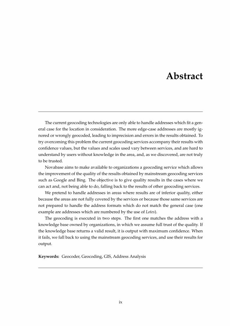
Taken literally, geocoding means “to assign a geographic code” [GWK07]. However, forthe purposes of this document, the terms “Geocoding” and “Geocoding Process”, will beassociated with the transformation of human readable addresses into geographic coordi-nates. This process, which is exemplified in Figure 1.1, varies in complexity, but can besimplified into two main steps: address standardization and translation of normalizedaddresses into geographic coordinates. In the normalization step, a series of operationsare applied to the address, reducing it into a format appropriate for the next step in thegeocoding process. The translation step, also called address matching, is where a seriesof algorithms are applied to the address in order to to acquire the coordinates for theaddress.
1.2.1.1 Normalization
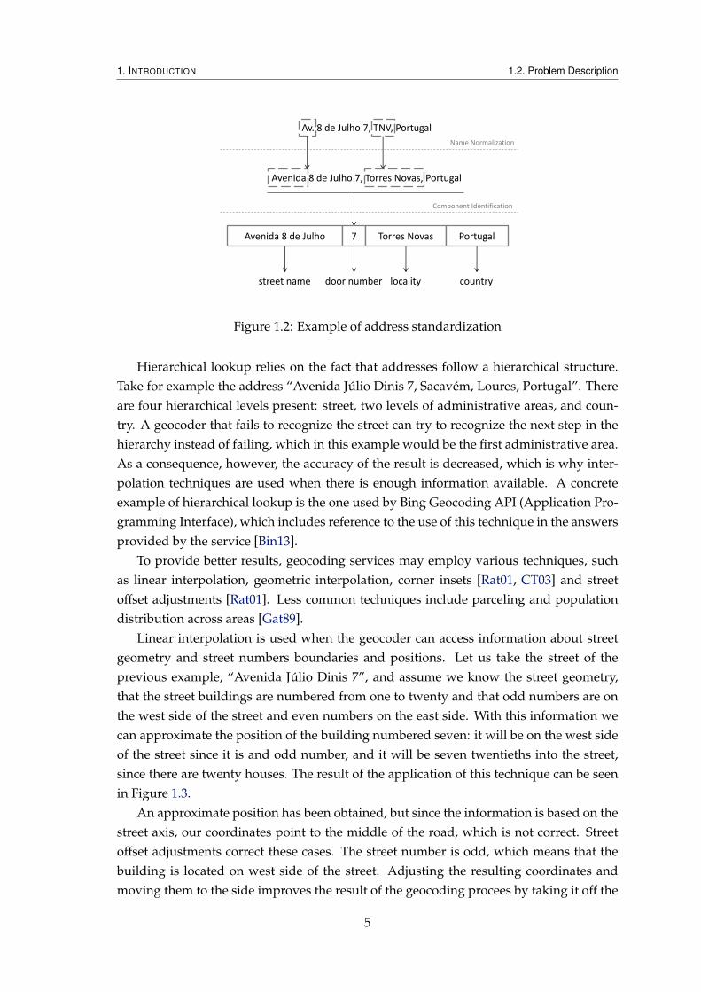
The first step of the geocoding process. It is the transformation of a human readable ad-dress into a programmatic representation of itself. This involves applying some transfor-mations [CCZ02] (such as lower casing the text, or removing punctuation) which convertthe address into an internal format, rigidly defined, that the geocoder is expecting to findin the following step. Two main concerns are tackled in this step: name normalizationand address components identification, as shown in Figure 1.2
Technically, it is possible to build a geocoding service without address normalization.However, at the very best, the resulting service would be very lacking in terms of results,since the absence of normalization implies that addresses are matched exactly as theycome from the source, character for character. Most services will implement at least somedegree of normalization. As the normalization applied to the addresses improves, so dothe results obtained in the following step.
Name normalization is the substitution and sometimes correction of words with com-mon synonyms with an equal equivalent. For example, in a street name the following
3

1. INTRODUCTION 1.2. Problem Description
Avenida 8 de Julho 7 Torres Novas Portugal
Av. 8 de Julho 7, TNV, Portugal
coordinates (lng, lat) confidence
Output
Input
Address Normalization
Address Matching
Figure 1.1: Geocoding example of a simple address
substitutions could happen: Avn. : Avenue and St : Street. The same is valid for theremaining parts of the address, such as locations and even street numbers: TNV : TorresNovas, PT : Portugal and no7 : 7.
This step can have various degrees of complexity [GWK07]. Some transformationscould be considered easy, such as token parsing and search in lookup tables, which couldpotentially be enough for most kind of word substitutions, and others are much morecomplex, such as probabilistic methods [CCW04] and machine learning techniques [CC02],which could be used to correct erroneous input and even fill missing information.
The next step involves the identification of the components of an address. It startswith the result of the name replacement step and goes from that line of text, which repre-sents an address, to the actual pieces that make it an address: door number, street name,postal code, and others. Each of these components are detected (if present) and storedfor later use in the address matching step.
1.2.1.2 Matching
Translation of the normalized address into coordinates is performed using a variety ofdifferent algorithms. The most observed techniques being address lookup, hierarchicallookup and interpolation techniques, which will be described in the remainder of thissection.
Address lookup is the simplest form of geocoding. A geocoder simply matches thenormalized address with the information it contains in its knowledge base and returnsthe coordinates associated with it. If no match is found, other techniques are applied.One possible option is hierarchical lookup.
4
1. INTRODUCTION 1.2. Problem Description
Avenida 8 de Julho 7 Torres Novas Portugal
Av. 8 de Julho 7, TNV, Portugal
Avenida 8 de Julho 7, Torres Novas, Portugal
street name door number locality country
Name Normalization
Component Identification
Figure 1.2: Example of address standardization
Hierarchical lookup relies on the fact that addresses follow a hierarchical structure.Take for example the address “Avenida Júlio Dinis 7, Sacavém, Loures, Portugal”. Thereare four hierarchical levels present: street, two levels of administrative areas, and coun-try. A geocoder that fails to recognize the street can try to recognize the next step in thehierarchy instead of failing, which in this example would be the first administrative area.As a consequence, however, the accuracy of the result is decreased, which is why inter-polation techniques are used when there is enough information available. A concreteexample of hierarchical lookup is the one used by Bing Geocoding API (Application Pro-gramming Interface), which includes reference to the use of this technique in the answersprovided by the service [Bin13].
To provide better results, geocoding services may employ various techniques, suchas linear interpolation, geometric interpolation, corner insets [Rat01, CT03] and streetoffset adjustments [Rat01]. Less common techniques include parceling and populationdistribution across areas [Gat89].
Linear interpolation is used when the geocoder can access information about streetgeometry and street numbers boundaries and positions. Let us take the street of theprevious example, “Avenida Júlio Dinis 7”, and assume we know the street geometry,that the street buildings are numbered from one to twenty and that odd numbers are onthe west side of the street and even numbers on the east side. With this information wecan approximate the position of the building numbered seven: it will be on the west sideof the street since it is and odd number, and it will be seven twentieths into the street,since there are twenty houses. The result of the application of this technique can be seenin Figure 1.3.
An approximate position has been obtained, but since the information is based on thestreet axis, our coordinates point to the middle of the road, which is not correct. Streetoffset adjustments correct these cases. The street number is odd, which means that thebuilding is located on west side of the street. Adjusting the resulting coordinates andmoving them to the side improves the result of the geocoding procees by taking it off the
5

1. INTRODUCTION 1.2. Problem Description
18 16 14 12 10 8 6 4 2 20
17 15 13 11 9 7 5 3 1 19
1 20
Figure 1.3: Geocoding with linear interpolation alone
road and into the locations of the houses. The new result can be seen in Figure 1.4.
18 16 14 12 10 8 6 4 2 20
17 15 13 11 9 7 5 3 1 19
1 20
Figure 1.4: Geocoding with linear interpolation and street offset
This approach works well when buildings fill the whole street, but in streets starting(or ending) in a V-shaped bifurcation, houses often start later (or end earlier). In suchcases there will be no buildings at the beginning (or end) of the street. To solve thisproblem, corner insets may be introduced. They force street numbering to begin (or end)only after a given distance and, in doing so, avoid the generation of results which locatebuildings at street extremes. The final result is in Figure 1.5.
The previous algorithms have a pre-requisite of information. It is assumed that infor-mation on street axis and street numbering and positioning is present. However, it mayhappen that some part of this information is not available, in which case they cannot beused. When this happens, one solution, before rising in the hierarchy, is to use geometricinterpolation, to obtain the centroid of the street [VMN01]. The centroid of a street is thecalculated center of the street, each point of the street is averaged and the results is thecentroid.
18 16 14 12 10 8 6 4 220
17 15 13 11 9 7 5 3 119
120
Figure 1.5: Geocoding with linear interpolation, street offset and corner insets
6

1. INTRODUCTION 1.2. Problem Description
Calculated centroid moved
to street axis
Figure 1.6: Geocoding with geometric interpolation
The centroid will normally be calculated far away from a point on the street, becausestreets are no rectilinear. Because of this a new calculation is performed to find the streetsegment which is closer to the centroid, and the middle of that segment is the chosenposition. This position is then returned as the approximate result. An example of appli-cation of this technique is shown in Figure 1.6. Here, the calculated centroid is locatedalmost behind the houses. To avoid this, the minimum distance between the centroid andthe street axis was calculated, and the centroid was moved to the resulting position.
1.2.2 The problems
These and other techniques exist to improve the results of what is a very complex anderror-prone process, and one of the problems of its complexity is that there are multiplepoints of failure.
Our research on the current geocoding services, presented in further Chapters, re-vealed some of those failures. The two most common errors where deduced to have theirorigins on out-of-date information and incorrect parsing of addresses.
1. Specific areas where every address fails are caused by out-of-date information orincorrect handling of address formats. This is normally seen in newly urbanizedareas and is easy to detect, but hard to correct.
2. Full streets are geocoded to the same location when the service being used doesnot correctly parse the street address.
3. A small number of addresses fail on unrelated locations. This can happen whenthe services has incomplete information on certain geographic zones. It is hard todetect since only one or two addresses may be affected in the same area, making ithard to notice when examining locations in bulk.
7
1. INTRODUCTION 1.3. Context
The first problem is mostly a symptom of out-of-date information, it usually hap-pens on locations which have been recently constructed (or reconstructed), and whenthe services have not yet obtained the new information. The time it takes for the newinformation to replace the old old varies between services and their data providers.
The second problem is a symptom of both out-of-date information and incorrect pars-ing of addresses. It may happen when new streets are build, and a new format addressis applied to them, in which case the geocoding service will not identify the street. Wheninstead of having a new street built, an old one is remodelled and the street numberingupdated, it may happen that services which have the old information incorrectly geocodethe addresses based on it.
The third one is rarer, and harder to detect. It normally affects only one or two ad-dresses on unrelated locations, when, for some reason, incomplete information is ob-tained. One observed case was a building which had its numbering hidden from streetview, and was not identified and included as a building in the street.
1.3 Context
Novabase is an international consulting and IT business which develops and integratesintellectual property with their partners and manufacturers. It offers business solutionsin a wide array of areas, such as telecommunications and media, manufacturing andservices, energy and utilities, aerospace and transportation, financial services, and gov-ernment and healthcare.
Novabase clients own and use georeferenced data, but it is being underused. They donot possess the means to correctly analyse and extract valuable information from it, andthis prohibits them from gaining insights which can be attained through spatial analysis.
There is a need to better explore the data these organizations possess. Insights ongeographic analysis can greatly enhance the operations of the organizations, and are cur-rently becoming a central focus of their departments, with more and more organizationsrequiring the geographic analysis capabilities.
1.4 Objectives
The aim of this project to contribute to the improvement of geocoding results of organi-zational entities. We provide them a customizable framework which can both leveragethe organization’s own intelligence and improve trust on the obtained results.
The target audience are small groups or single individuals within organizations whopossess the potential to leverage geographic information but do not possess the requiredknow how to accomplish it. The application will fill these users needs by opening thepossibility to better understand their own information in its appropriate context, withoutthe need to understand the GIS machinery behind it.
8
1. INTRODUCTION 1.5. Contribution
Our intention is to help improve the overall quality of the current geocoding servicesand technologies. We do not intend to replace the current set of solutions available, butto build an application which works with them to improve results. With that in mind wedefined the following objectives:
• Allow the geocoding of a big number of addresses at the same time (batch/bulkgeocoding)
• Decrease the barrier of entry and learning curve by providing abstractions over theGIS technologies
• Enabling and facilitating the use of information the organizations already possess
• Allow easy integration of new geocoding services into the process, thus allowingeasy cooperation with future technologies
• Give access to the the results in such a way that facilitates its integration with otherapplications
• Permit quick and contextual visualization of results through the use of maps
• Allowing effortless detection and correction of geocoding problems
• Eventual inclusion of the resulting application both in other projects of Novabaseand with their clients
• Provide great usability to facilitate the use of the application (This objective wasposteriorly dropped due to time limitations)
1.5 Contribution
We hope to improve and contribute to the use of geographical information and spa-tial analysis within organizations. Transforming addresses, which organizations alreadyhave associated with their other information, into geographic coordinates is the first stepwhich opens a myriad of possibilities.
Our solution is able to use as source various geocoding services already present,bringing the best of their results to a common application. One of its greatest advan-tages is its ability to leverage the information already owned by organizations and use itin cooperation with the results of the currently available geocoding services.
By bringing together the best results of the current services with owned information,the results can be improved upon without lost of quality, something which was previ-ously hard to do, when the choice was between using either of them, instead of usingboth.
The feedback capabilities included in the solution enable a greater trust on the qual-ity of the results. Before it was difficult to perceive the quality of the results, but with
9

1. INTRODUCTION 1.5. Contribution
our feedback system the application is able to detect problems before hand, and warnorganizations about what it finds. This enables users to verify a big number of resultswith minimal effort, while still being able to pinpoint small irregularities which wouldotherwise be hard to detect. The biggest advantage of this feature is that it can be usedwith the results of mainstream geocoding services as well as the ones which comes fromthe knowledge base. This means that even without a knowledge base, quality and trustin the results of these services can still be improved upon.
By enabling organizations to use their already owned data and making them aware ofthe quality of the obtained results, we aim to improve their trust on GIS, thus propagatingits wide-spread adoption in every organization.
10
2State of the Art
To better understand the current standing of geocoding technologies Novabase requiredtwo different studies. One side objective of these studies was to allow us to grasp someof the fundamental concepts and to recognize common pitfalls.
One of the studies examines geocoding applications which are, at least partially, freelyavailable for use by users. The applications are tested in various areas and results arecompared between them. This allows us to considerate which are the practices that areworth emulating, and which we should avoid.
The second one studies two geocoding service APIs: Google Geocoding Service APIand Bing Maps Geocoding Service. Both APIs results are analysed and evaluated, inan attempt to distinguish which would better server our purposes. Novabase showedinterest in using the Google API, but if this analysis revealed the Bing API to be overallbetter suited, a move from one to the other would be done.
The conclusions derived from these studies are presented in the end of the Chapter,in Section 2.3, Discussion.
2.1 Application Analysis
The current market of geocoding services was studied with the objective of better under-standing the current status of the technology. From this research we tried to learn whichwere bad practices we could try solve or avoid in our planned application.
Applications were selected from a wide variety of case studies, but for the deeperanalyses described here, they add to fill three requirements:
11

2. STATE OF THE ART 2.1. Application Analysis
1. Ability to geocoded addresses in bulk We are testing in an organization environ-ment, for the use case where they need to geocode a big group of addresses
2. Ability to collect or visualize the results Because we need someone way to verifythe quality of those results.
3. Ability to geocode international addresses Many geocoders initially consideratedonly allowed for US addresses, but sample tests were composed of Portuguese ad-dresses
After the filtering we were left with five remaining applications:
• BulkGeocoder [Bul13]
• Find Latitude and Longitude [Fin13]
• Batch Geocoder [Bat13]
• GPS Visualizer [GPS13]
• Topo.ly [Top13]
The applications were tested on three aspects which were deemed to be the focus ofour solution by Novabase: quality of results, features available, and usability.
Quality of results evaluates if the applications are able to geocode the given ad-dresses or if they fail, giving no results. It additionally evaluates whether the successfullygeocoded addresses are actually correct or not. There are many case in which geocodersmay give a wrong result, due to reasons described in previous Chapters, and these shouldnot be considered as correct or valid.
Availability of features tested for additional features besides the geocoding of ad-dresses. We recognize that there is much value to be gained from whether or not appli-cations do something else to the results, such as showing them on a map or presentingthem with a confidence level.
Functional aspects are not the only ones which influence the evaluation that usersmake of applications. Usability is a big part of it, and, unless users are severely con-strained, they will not choose an application with poor usability (even if it has slightlybetter results) over one with rich usability [RDA01].
Each area is discussed in detail in its own section: 2.1.1, Geocoding Results Analysis,2.1.2, Feature Analysis and 2.1.3, Application Usability, respectively.
2.1.1 Geocoding Results Analysis
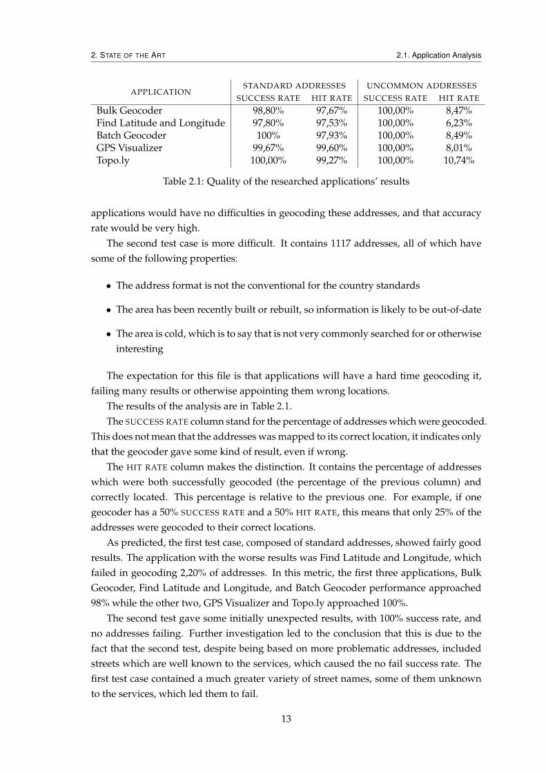
To test the quality of the results of the geocoding of addresses we produced two testcases. The first test case contained 1500 standard addresses, which is to say that no edgecases or newly constructed areas were included. The expectation was that the chosen
12
2. STATE OF THE ART 2.1. Application Analysis
APPLICATIONSTANDARD ADDRESSES UNCOMMON ADDRESSES
SUCCESS RATE HIT RATE SUCCESS RATE HIT RATE
Bulk Geocoder 98,80% 97,67% 100,00% 8,47%Find Latitude and Longitude 97,80% 97,53% 100,00% 6,23%Batch Geocoder 100% 97,93% 100,00% 8,49%GPS Visualizer 99,67% 99,60% 100,00% 8,01%Topo.ly 100,00% 99,27% 100,00% 10,74%
Table 2.1: Quality of the researched applications’ results
applications would have no difficulties in geocoding these addresses, and that accuracyrate would be very high.
The second test case is more difficult. It contains 1117 addresses, all of which havesome of the following properties:
• The address format is not the conventional for the country standards
• The area has been recently built or rebuilt, so information is likely to be out-of-date
• The area is cold, which is to say that is not very commonly searched for or otherwiseinteresting
The expectation for this file is that applications will have a hard time geocoding it,failing many results or otherwise appointing them wrong locations.
The results of the analysis are in Table 2.1.The SUCCESS RATE column stand for the percentage of addresses which were geocoded.
This does not mean that the addresses was mapped to its correct location, it indicates onlythat the geocoder gave some kind of result, even if wrong.
The HIT RATE column makes the distinction. It contains the percentage of addresseswhich were both successfully geocoded (the percentage of the previous column) andcorrectly located. This percentage is relative to the previous one. For example, if onegeocoder has a 50% SUCCESS RATE and a 50% HIT RATE, this means that only 25% of theaddresses were geocoded to their correct locations.
As predicted, the first test case, composed of standard addresses, showed fairly goodresults. The application with the worse results was Find Latitude and Longitude, whichfailed in geocoding 2,20% of addresses. In this metric, the first three applications, BulkGeocoder, Find Latitude and Longitude, and Batch Geocoder performance approached98% while the other two, GPS Visualizer and Topo.ly approached 100%.
The second test gave some initially unexpected results, with 100% success rate, andno addresses failing. Further investigation led to the conclusion that this is due to thefact that the second test, despite being based on more problematic addresses, includedstreets which are well known to the services, which caused the no fail success rate. Thefirst test case contained a much greater variety of street names, some of them unknownto the services, which led them to fail.
13

2. STATE OF THE ART 2.1. Application Analysis
Nonetheless, when examining the results were led back to our expectations. Onlyaround 10% or less of the addresses are correctly geocoded. What happened with mostapplications was that they recognized the streets in the addresses, but failed to providecorrect building locations, either due to having no information on the actual dispositionof buildings in the area, or because the parsing of the street number failed.
In most cases, in addresses with complex door numbering, such as 2.06.1.A, the num-ber was reduced to just the first or second number, and the remaining discarded. Thisled to all addresses with similar door numbers being geocoded to the same position.
For undocumented areas the most common error was decreasing the precision of thestreet name. What we here call “decreasing of the precision of the street name” canbe better described by an example. Think of the the address Street Channing and
Crawford, which the geocoder does not recognize. What was observed was that somegeocoders would drop parts of the address if that would increase the HIT RATE, and in-stead give results in Street Channing or Street Crawford, if they existed. Thislead to a higher SUCCESS RATE but a lower HIT RATE.
2.1.2 Feature Analysis
In this study, key features were identified and evaluated for all applications. These fea-tures were chosen based on the interests Novabase had for its solution. The results can befound in Table 2.2, and the explanation of the features and their reasoning for selection isin the following list.
• Provider The name of the geocoding service the application uses. Since we intendto include the use of mainstream geocoding services in our solution, it is interestingto see how applications which also use them fare in their results.
• Input The formats in which the application accepts the information. Acceptanceof many formats of data is considered important because it removes work loadfrom users. The target users are businessmen which do not care for the problemsinvolved in this, and expect their information to be simply accepted. Difficulties inthis area would be considered a big downside for applications.
• Output the formats in which the application returns the geocoded information.This follows the same rational of the previous point, the most important point be-ing that the output is expected to be in the same format as the input, even thoughsometimes it is useful to have options which allow additional formats.
• Confidence Whether the application accompanies its results with confidence levels,and what kind of levels it uses. This is important to increase trust on the finalresults. It is widely known that geocoding results are not always accurate. Thepresence of confidence values may be the deciding factor on whether users trustthe results of the application or not.
14
2. STATE OF THE ART 2.1. Application Analysis
APPLICATION PROVIDER INPUT OUTPUT CONFIDENCE
Bulk Geocoder — CSV & Excel Text TextualFind Latitude & Longitude Google Text 0-9 by regionBatchgeo — Tabular Text Map —GPS Visualizer Various Text Various —Topo.ly — Tabular Text — —
Table 2.2: Features of the researched applications
Of all the applications, only two of them discriminate their sources. Find Latitude andLongitude uses the Google Geocoding API, and GPS Visualizer gives users the option tochoose either Google or Yahoo! BOSS PlaceFinder. Some of the applications consideredin the initial phase of the research also used the Bing Geocoding Service or the MapQuestGeocoding API. Unfortunately they were not appropriate for testing. Some lacked thenecessary features (e.g. not allowing batch address processing), others were limited tocertain geographic areas (e.g. North America).
Bulk Geocoder is the only application supporting direct file upload, with the limita-tion that it must be in the CSV format or, if users require it, an Excel file sent vial emailto the application’s team. After uploading the file, users have the ability to specify whichcolumns of the file contain relevant information (e.g. which contains data on the address,locality or country). All other applications require text input through web forms. FindLatitude and Longitude accepts a syntax were each line represents a whole address, whileBatchgeo and Topo.ly require a syntax similar to CSV, but where values are separated bya tab character instead of by a comma. GPS Visualizer and Topo.ly require the headers tohave appropriate names, such as “Address”, while Batchgeo follows the example of BulkGeocoder, and allows users to specify which columns contain which information.
The output of the applications is more diversified. Bulk Geocoder provides results inthe same file format as they were sent, either CSV or Excel. Find Latitude and Longitudeand GPS Visualizer deliver simple text, both using CSV syntax. Batchgeo is the only onewhich does not allow direct access to the geocoded information, instead it returns a URL.This link is to their domain, and leads to a page where a Google Map is displayed withthe geocoded addresses. A relevant feature of this page is that it enables the manipu-lation of the appearance of the markers used to visualize the adresses, according to thedata initially provided. It is even possible present additional information, which was notrelevant for the geocoding process itself. GPS Visualizer is the most flexible applicationin this metric, it allows output in a myriad of formats: text with CSV syntax, geographicfile formats such as KML or GPX, and various image formats such as JPEG or PNG.
Confidence levels are only provided by two of the applications. Bulk Geocoder at-tributes textual confidence levels such as Building, which means that the location is asso-ciated with a particular building or house, or Address, meaning that the position refers tosomewhere on the street of the building, but not on its exact location. The numeric levelsreturned by Find Latitude and Longitude can be associated with a value of confidence in
15

2. STATE OF THE ART 2.1. Application Analysis
APPLICATION INTERFACE INPUT GEOCODING OUTPUT TOTAL
Bulk Geocoder Neutral Good Neutral Good Good (2)Find Latitude & Longitude Neutral N/A Neutral Good Good (1)Batchgeo Good Good Good Good Good (4)GPS Visualizer Bad N/A Good Bad Bad (-1)Topo.ly Good Neutral Bad Good Good (1)
Table 2.3: Usability scores of the researched applications
the result, from 0 to 9, where 0 means that the geocoding failed and 9 that the result hasprecision to the building level.
2.1.3 Application Usability
Four usability features were analysed for each application. These four were determinedto be the ones which would have the bigger impact on the evaluation of users. They arekey points and users are certain to focus their attention on these areas.
A summary of the results are presented in Table 2.3, where each Good adds one pointto the classification of the application and each Bad subtracts one point. The descriptionof the meaning of the features (table columns) is as follows:
• Interface Encompasses several aspects of the application such as look and feel, easeof use and navigation, and error reporting and correction;
• Input Deals with everything the user has to do until the application is able to startthe geocoding process, such as file uploading and structuring;
• Geocoding Analyses user control of the geocoding process, for example, monitor-ing and network resilience;
• Output Examines data retrieval and visualization capabilities of the application.
The following sections analyse the applications according to the chosen features. Theanalysis takes into account that a more feature-filled application will be more complex todevelop and handling, providing more space to fail, while a less featured one will be ableto efficiently do what it does better.
2.1.3.1 Bulk Geocoder
The interface demonstrates both good and bad practices, earning a Neutral score. It en-ables quick access to the geocoding process, even if with a lightly cluttered interfacewhich easily distracts users. The instructions are clear and easy to follow but indistin-guishable from normal page text. There is no indication of which fields are required ornot, and users are only notified when they try to start the geocoding process and faildue to incomplete requirements. Each field does, however, present information on whatcontent it is supposed to be filled with.
16

2. STATE OF THE ART 2.1. Application Analysis
The input step is one of the fields which earned a Good score. CSV files are the onlyones supported for upload and the operation is well designed, with progress indicatorsand error handling. There is a step that allows the users to specify which columns containwhich information, after which the geocoding process initiates.
The user does not, however, have any control over the geocoding process. There areno progress indicators or time estimations of any sort. Once the process starts, the onlything users can do is wait for an e-mail containing a link to the results. The only indicationavailable is a note on the page, which refreshes every ten minutes, informing the user thatthe process is still ongoing. Despite that, the process is not affected by network instability,which gives it a ranking of Neutral.
Post-Geocoding improves the overall score, receiving a Good rating. Geocoding re-sults come with a confidence level, showing the precision of the results in text form(Building, Address, etc.). The results are safe on the application’s servers and can beverified before download. Unfortunately, there is no way for users to reach their resultsthrough the application, this is only possible by e-mail, when the geocoding process ends.Results can be downloaded in either CSV or Excel files after payment, which is based onthe number of addresses processed. The downloaded files include all the original infor-mation, plus three additional columns: latitude, longitude and (optionally) confidence.
2.1.3.2 Find Latitude and Longitude
This Interface was rated as Neutral. It includes step by step, clear and easy to followinstructions. All the information about input of addresses and output of coordinates isdescribed in detail and in an intuitive way. Although simple and concise, the interface isalso disorganized and overly aggressive, which may scare potential users. Going throughthe main page in order to reach the one that does the batch geocoding is difficult, requir-ing the user to focus on an information dense area with potentially misleading names.
Input is inserted through a simple text area, which accepts one address per line. Thisis a case where usability can only be measured on the ability to copy and paste, and sincethat is something handled by the browser, not the application, it is not valid for this study.
The Geocoding process received a Neutral rating. The process can be monitored,every time an address is geocoded, the results are always displayed and are immediatelyavailable for use. The whole process is susceptible to network failures, but when theyhappen the results are not lost. Resuming the process is realized manually and requiresthe users to check themselves where the process failed and resuming from there.
The output step also received a Good rating. Geocoding results come with a confi-dence level with a scale of 0-9 by region, 0 being a failed geocoding, 1 being a countryand 9 an exact building. These results are available within the application and limited tothe session. If users close the page, the results are lost. They are easy to export, comingin textual CSV format.
17
2. STATE OF THE ART 2.1. Application Analysis
2.1.3.3 Batchgeo
This application’s interface received a Good rating. It gives the user a pleasant and fluidexperience with direct and simple instructions. There are examples of the kind of inputdata the application expects and once users insert their own it is validated and can beverified.
The input step also earns a Good rating. Users can tell the application what is keptin which fields and there are examples both of what is expected and of the outcome ofthe process. Extraneous information is safely ignored by the application and does notimpede the geocoding process.
The Geocoding process, once again, receives a Good rating. The progress can be mon-itored and is cancelable. When the operation is cancelled, the user still has access to thegeocoded information, and can even continue to the output step with it. However, it doesnot tolerate network failures. When they do happen, it halts, and although the processedinformation is not lost, the steps to salvage it are not intuitive; it is also impossible toresume it without starting over.
Even though the output options are very limited, the one they do provide is verywell designed, which gives this application a Good rating. Results are presented on amap enabling manual correction and the generated data is permanently stored withinthe application. Even though it no confidence indication is provided, verification of smallsets of results are facilitated by the map visualization that the application provides.
2.1.3.4 GPS Visualizer
The Interface for this application evaluated to a Bad rating. Instructions are undifferen-tiated from main text and, once found, are unclear and hard to read. Input fields aredisorganized and, aside from the label, no explanations for their purpose is provided.
As with Find Latitude and Longitude the input step on this application is handledby the browsers ability to copy and paste the information, and as such it can not beevaluated.
The Geocoding process earned the only Good rating of this application. It can bemonitored and allows its cancellation, although not its resuming. It is susceptible tonetwork failures and the process halts as if users had pressed the cancel button. Everytime an address is geocoded the information is immediately shown to the user, both intext and on a map. Validation of information can be done using this map.
The output step comes back down again to a Bad rating. The only two factors infavour are that results are accessible within the application and are easy to export astextual CSV data, a geographic file type or as an image. This is, however, not enough toovercome the fact that data verification is hard for more than a small number of requests.Results are temporary and closing the site will void any work done.
18
2. STATE OF THE ART 2.1. Application Analysis
APPLICATION RESULTS FEATURES USABILITY
Bulk Geocoder - · ·Find Latitude and Longitude - · ·Batchgeo - - +GPS Visualizer - - ·Topo.ly - · +
Table 2.4: Usability scores of the researched applications
2.1.3.5 Topo.ly
This application earned a Good rating on the Interface. Besides the fact that is has a fewinterface elements that are not intuitive and may confuse the user, it is well designed.The overall experience is smooth and pleasant, its use is easy and responsive, and thereare clear and contextualized instructions on every step of the process.
The input step gained a Neutral rating. It accepts extraneous information on input,saving the user the trouble of its manual removal. It has a validation step but it is not userfriendly. Most error messages are too cryptic for normal users, leaving them confusedand without alternatives to proceed. To know which types of header the applicationexpects, users need to leave the process and look for a solution in the FAQ page.
Failures in the Geocoding process bring it down to a Bad rating. The process can bemonitored and cancelled, but when users cancel the process all data gathered until thenis lost. The application has no way to recover from problems in the network and any ofthose problems voids the operations. There is an indicator showing the progress of theprocess, but no partial results are given.
In the output step it comes back to a Good rating once again. The visualization of datais highly simplified by using a map, the generated data is permanently stored, and resultsare accessible within the application without requiring its download. Unfortunately, wecould not gather any information on file downloading, since every download option isblocked until payments are provided. Additionally, no confidence indicators of any kindare provided.
2.1.3.6 Analysis Conclusion
The overall evaluation of the five applications can be found in Table 2.4. As mentionedbefore, every application performs poorly when geocoding edge cases addresses, posi-tion most addresses in the wrong locations. In itself, failing to geocode is not necessarilybad, what brings the score down is that all the applications geocode almost every addresson the wrong locations, leading the users into erroneously believing they got accurate re-sults. It is not wrong to fail, but it is wrong to give incorrect results.
On the features front, most applications provide at least some functionality. BulkGeocoder and Find Latitude and Longitude accompany their results with confidence lev-els, which, in theory, would be a great feature, but in practice, because most results come
19

2. STATE OF THE ART 2.2. API Comparison
Avenue D 13, Mayhem 13 Avenue D Mayhem
full address door number locality street name
formatted address location address line
Avenue D 13, Mayhem Mayhem Avenue D 13
BING
Figure 2.1: Street components information
out wrong but with good confidence levels, only further misinforms users. Batchgeo andTopo.ly do not provide any confidence levels with their results, but compensate by al-lowing their cartographic visualization. This is an ad-hoc verification mechanism, andwhile is not as usable as confidence values, in this particular case, where most resultscome out wrong, it provides more accurate information to users. The lack of ability toreally give useful and true confidence metrics is what stops the applications from beinggiven higher scores.
While none of the applications have particular detrimental usability, most of themcould be improved. The exception being Batchgeo, which earned positive evaluationson every front. The one downside of the application, in comparison with others, is thelack of access to the generated data, but for what the application was designed to do, itsusability is an example to follow.
2.2 API Comparison
A requirement for this project was the detailed comparison of two different geocodingAPIs: Google Geocoding API and Bing Maps Geocoding Service. Along with the exam-ination of the documentation of both [Bin13, Goo13], they were also tested to obtain amore deep knowledge on their inner workings and ease of use.
When they are not certain to provide a correct result, both services will answer withmore than one set of coordinates. One of them will normally fit the query better than theothers and will come in first place in the ordering of the results.
As can be seen on Figure 2.1, both Google and Bing will provide information on thetype of result (street, road, locality, etc) both for the full address and for each addresscomponent, but the data comes organized in a slightly different way.
While in Bing we have direct access to each component of the address, in Googledevelopers are forced to search every component until they find the one they are looking
20

2. STATE OF THE ART 2.2. API Comparison
BING
location type
confidence calculation method trust
• High • Medium • Low
• Exact • Interpolation • Interpolation + offset • Geometric center
• Good • Ambiguous • Up In Hierarchy
• Exact • Linear Interpolation • Geometric Interpolation • Approximate
Figure 2.2: Different types of confidence information for each service and their values
for. This comes at the cost of future flexibility. If a new type of address is created, Googledoes not need to change it’s data structure to accommodate for it, while Bing will haveto introduce a new version of the API, which can represent it, or be forced to use a non-standard field.
Both services have a field indicating how the value was calculated. Google only dif-ferentiates between exact, linear interpolation and geometric interpolation. Results which donot fit into this category will appear as approximate. Bing has one more option, linear inter-polation with offset, but the most inaccurate option is geometric interpolation, which meansthe worse results will all gather under this value.
Bing comes with two more fields which can be used to infer confidence and accuracyon the results. The first one is a field called confidence, which can have the values of“Low”, “Medium” or “High”. The other, trust, has three possible values: Good, meaningthe result has a good quality; Ambiguous, meaning there is more than one possible resultfor the address; and Up In Hierarchy, which indicates that the service was not able to finda result for the more precise address and instead returned the one above it (for example,returning the position of the location (e.g. the town) instead of the street). To have aclearer, less-textual idea of what each service has, check Figure 2.2.
Candidate Results are the ones that also seem to fit the query, but in which the servicehas less confidence than in their first result. They are present in case the application usingthe service is able to recognize any of them as a more fitting alternative. Figure 2.3 showsthat Google has much more information for these. It answers with full information onthem, while Bing will only give information on coordinates and calculation method. Thismeans that each Bing response will be a lesser strain on the network. However, if moreinformation is required by the client, the strain on the network will increase because new
21

2. STATE OF THE ART 2.2. API Comparison
BING
Best Match Candidate Match Candidate Match …
Full Information Coordinates + Calculation Method
Coordinates + Calculation Method …
Best Match Candidate Match Candidate Match …
Full Information Full Information Full Information …
Figure 2.3: Information given for each candidate result in both APIs
requests will be made, while with Google there is no such need, since all the informationcomes in the first response.
Not as important for the results themselves, but still interesting while displaying themin a map, is that both services answer with a bounding box. This box has coordinateswhich make up a rectangle, which can be used as an appropriate viewport when focusingon the cartographic representation of a single result.
2.2.1 Google Geocoding Service API Analysis of Results
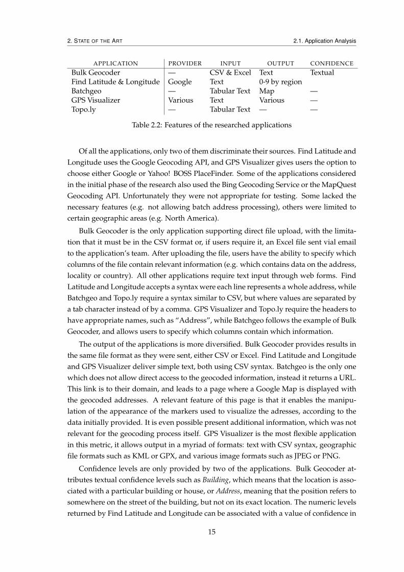
Becuase Novabase required the use of Google Geocoding Service API, a more thoroughanalysis was performed on this service’s results. The second sample file mentioned in2.1.1, which had the more difficult addresses, had its results carefully analysed. Theresults are presented in this section.
The minimum accepted distance from a real location to a result given by a geocodingservice varies with the intended use of the information, but for the purposes of theseanalysis, twenty five metres will be considered the maximum distance at which a locationis considered correct. A larger difference will be interpreted as a geocoding failure.
Analysing Figure 2.4 it is possible to see that only 20% of the results fall within twentyfive meters of the correct location. The remaining 80% are geocoded far away, renderingthem erroneously located. If one assumes that results which are more than one kilometreaway from the correct location are so because the address has been incorrectly parsed(and as such, can be corrected), there are still 50% of addresses which are positioned at adistance of more than twenty five metres from the real location.
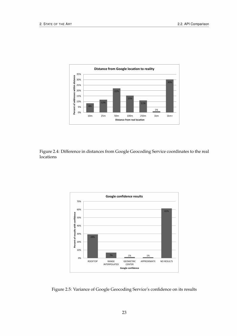
Despite that, one could argue that Google results come with a confidence result asso-ciated, which can be used to avoid accepting wrong results as correct. Further analysis,shown in Figure 2.5 shows the confidence values which accompany Google results.
This analysis is somewhat skewed, since the data was purposely selected such thatGoogle would fail many of the results. By removing the failed results it is possible to get
22
2. STATE OF THE ART 2.2. API Comparison
8%
12%
22%
15%
11%
1%
30%
0%
5%
10%
15%
20%
25%
30%
35%
10m 25m 50m 100m 250m 1km 1km+
Pe
rce
nt
of
add
ress
es
wit
hin
dis
tan
ce
Distance from real location
Distance from Google location to reality
Figure 2.4: Difference in distances from Google Geocoding Service coordinates to the reallocations
29%
7% 1% 1%
61%
0%
10%
20%
30%
40%
50%
60%
70%
ROOFTOP RANGEINTERPOLATED
GEOMETRICCENTER
APPROXIMATE NO RESULTS
Pe
rce
nt
of
resu
slts
wit
h c
on
fid
en
ce
Google confidence
Google confidence results
Figure 2.5: Variance of Google Geocoding Service’s confidence on its results
23
2. STATE OF THE ART 2.2. API Comparison
76%
18%
3% 3% 0%
10%
20%
30%
40%
50%
60%
70%
80%
ROOFTOP RANGE INTERPOLATED GEOMETRIC CENTER APPROXIMATE
Pe
rce
nt
of
resu
lts
wit
h c
on
fid
en
ce
Google confidence
Google confidence results
Figure 2.6: Variance of Google Geocoding Service’s confidence on its results (not includ-ing failed results)
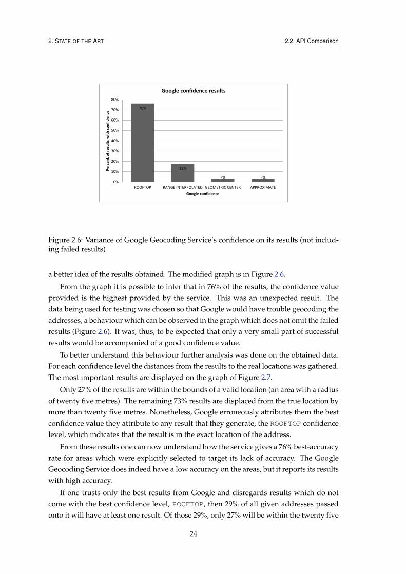
a better idea of the results obtained. The modified graph is in Figure 2.6.
From the graph it is possible to infer that in 76% of the results, the confidence valueprovided is the highest provided by the service. This was an unexpected result. Thedata being used for testing was chosen so that Google would have trouble geocoding theaddresses, a behaviour which can be observed in the graph which does not omit the failedresults (Figure 2.6). It was, thus, to be expected that only a very small part of successfulresults would be accompanied of a good confidence value.
To better understand this behaviour further analysis was done on the obtained data.For each confidence level the distances from the results to the real locations was gathered.The most important results are displayed on the graph of Figure 2.7.
Only 27% of the results are within the bounds of a valid location (an area with a radiusof twenty five metres). The remaining 73% results are displaced from the true location bymore than twenty five metres. Nonetheless, Google erroneously attributes them the bestconfidence value they attribute to any result that they generate, the ROOFTOP confidencelevel, which indicates that the result is in the exact location of the address.
From these results one can now understand how the service gives a 76% best-accuracyrate for areas which were explicitly selected to target its lack of accuracy. The GoogleGeocoding Service does indeed have a low accuracy on the areas, but it reports its resultswith high accuracy.
If one trusts only the best results from Google and disregards results which do notcome with the best confidence level, ROOFTOP, then 29% of all given addresses passedonto it will have at least one result. Of those 29%, only 27% will be within the twenty five
24

2. STATE OF THE ART 2.3. Discussion
12% 15%
27%
19%
13%
1%
13%
0%
5%
10%
15%
20%
25%
30%
10m 25m 50m 100m 250m 1km 1km+
Pe
rce
nt
of
resu
lts
Distance from real
Distance of Rooftop locations from real
Figure 2.7: Difference in distances with ROOFTOP confidence
metre radius which we ascertained would be the area for a correct result. This means thatof all the addresses passed onto the service, only 7,83% of them will carry an acceptablecorrect codification for the addresses. Taking into account that 71% of the addresses giveno valid results, we end up with a total of 21,17% of the total addresses being erroneouslygeocoded.
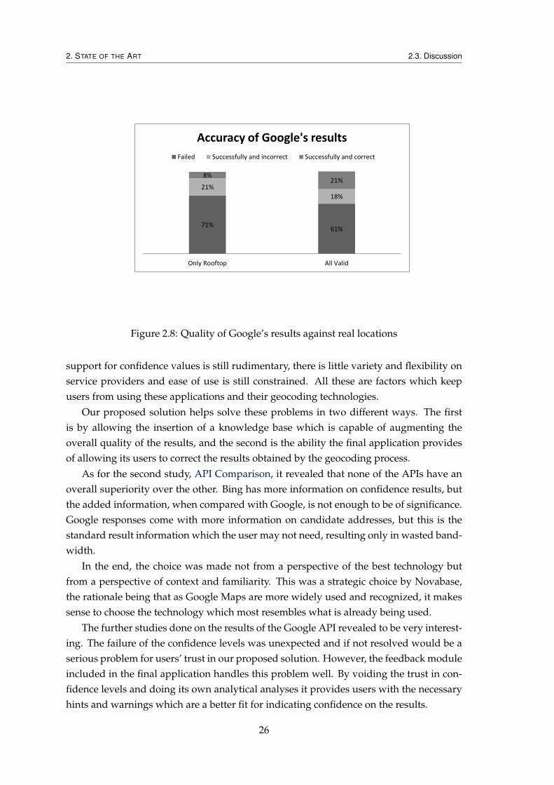
Extending the previous analysis to also include results with confidence levels besidesROOFTOP leads to another interesting development. As can be seen in Figure 2.8, if onetakes into account all valid results, there will be an almost threefold increase in the accu-racy of the results, which means that some results for which the service gives less thanperfect accuracy do end up being correct. This leads us to the conclusion that the confi-dence is not correct, and that it should not be trusted.
2.3 Discussion
From the first study, Application Analysis, we concluded that all applications are cer-tainly usable if one assumes the data does not contain problematic addresses. However,it is not easy for users to distinguish between addresses which the applications are ex-pecting and which they are not, services are expected to answer all queries with the samequality, but this does not happen. The fact that applications do not provide any means forusers to ascertain their trust on the results only worsens this, making most applicationsunusable at organizational levels.
Geocoding applications do not yet fill the target market we are aiming for, they donot allow organizations to rely and improve on the applications results. Additionally,
25
2. STATE OF THE ART 2.3. Discussion
71% 61%
21%
18%
8% 21%
Only Rooftop All Valid
Accuracy of Google's results
Failed Successfully and incorrect Successfully and correct
Figure 2.8: Quality of Google’s results against real locations
support for confidence values is still rudimentary, there is little variety and flexibility onservice providers and ease of use is still constrained. All these are factors which keepusers from using these applications and their geocoding technologies.
Our proposed solution helps solve these problems in two different ways. The firstis by allowing the insertion of a knowledge base which is capable of augmenting theoverall quality of the results, and the second is the ability the final application providesof allowing its users to correct the results obtained by the geocoding process.
As for the second study, API Comparison, it revealed that none of the APIs have anoverall superiority over the other. Bing has more information on confidence results, butthe added information, when compared with Google, is not enough to be of significance.Google responses come with more information on candidate addresses, but this is thestandard result information which the user may not need, resulting only in wasted band-width.
In the end, the choice was made not from a perspective of the best technology butfrom a perspective of context and familiarity. This was a strategic choice by Novabase,the rationale being that as Google Maps are more widely used and recognized, it makessense to choose the technology which most resembles what is already being used.
The further studies done on the results of the Google API revealed to be very interest-ing. The failure of the confidence levels was unexpected and if not resolved would be aserious problem for users’ trust in our proposed solution. However, the feedback moduleincluded in the final application handles this problem well. By voiding the trust in con-fidence levels and doing its own analytical analyses it provides users with the necessaryhints and warnings which are a better fit for indicating confidence on the results.
26

3Methodology
Geocoding is a complex process. Data, such as addresses and geographic coordinates,need to be collected in the field to be processed and inserted into a knowledge base. Theaddress component of the data is not uniform, different countries have different rules fordescribing an address, and even a single country can have more than one way do to it.
To better understand this problematic and obtain insights which could be useful tothe project, we took the initiative of collecting data in the field.
There was one type of address which was known not be handled correctly in main-stream geocoding services, due to it having a specific format, which breaks current rulesof door numbering in Portugal. Further testing on some of those services, such as Googleand Bing Maps, revealed that this was indeed the case. Of the affected zones we choosetwo in Parque das Nações, Lisboa and visited them to collect the correct addresses and co-ordinates.
To collect the data, aerial images of the chosen zones were printed to take to the field.Once there, we would highlight in each sheet of paper each of the addresses found, andnote down the street and door number. The compilation of addresses resulted in aroundthree hundred addresses collected over the span of one week. The addresses were thengeoreferenced and converted into digital format using a GIS application. The locations ofthe addresses were plotted onto a digital aerial map, and from those the application wasable to retrieve the geographic coordinates for each location.
The knowledge base now has three hundred addresses, but these only cover one veryspecific area, in which it was feasible to gather data via field work. To widen the spec-trum of our data we used geographic information on street addresses provided by theCâmara Municipal da Amadora. The data was studied and the addresses which failed tobe correctly geocoded by mainstream geocoding services were selected to be included in
27

3. METHODOLOGY
Geocoding
Analyses
Mapping
Correction
Coordinates obtained
Addresses Corrections of address
or of coordinates?
Address
Coordinates
Geocoded addresses
Figure 3.1: Work flow of our proposed solution
our knowledge base.With these two sources loaded into our knowledge base, the number of addresses
available rose to eleven hundred. With these addresses it became possible to test main-stream geocoding services against real data. Of those available Google Geocoding Servicewas the chosen one.
Taking into account the previously established objectives and this information ob-tained through the studies done in State of the Art, we devised the work flow shown inFigure 3.1. It is important to note that the knowledge base is not meant to cover everysingle address it may be thrown at it. It should be thought of as an improvement on thequality of the results of other geocoding services, to be used side by side with them toobtain the best quality data available.
However, to obtain the most accurate geographic coordinates, Novabase clients mustprovide a series of addresses to build the knowledge base for the application. The finalproduct is still able to provide functionality even without it, but this knowledge base isthe one with the potential to greatly increase the overall quality of the results.
The work flow is composed of six distinct steps:
1. Addresses The provision of addresses to the application
2. Geocoding The process by which the application obtains coordinates for all theaddresses
3. Coordinates obtained The coordinates are saved and made available
28

3. METHODOLOGY
4. Mapping The addresses are mapped to the coordinates obtained in step 2
5. Analysis A series of operations are effectuated in the obtained results to generatefeedback to users
6. Correction Users can chose to correct any number of locations, depending on thenature of the correction these are inserted back in steps 2 or 3
7. Geocoded addresses Users obtain the geocoded addresses
In step 1, to obtain the most accurate geographic coordinates, users (Novabase clientcompanies) must be able to provide a series of addresses. The more these addressesmatch with the ones in the knowledge base, the best the results will be. The individualcomponents of the addresses (street name, door number, etc.) can be provided indepen-dently from each other or joined together in a single unit of information. In each case, theapplication tries to distinguish which pieces of information are relevant and can be usedto find the address coordinates, ignoring the rest.
In step 2 these addresses will then be geocoded against the application internal knowl-edge base. This knowledge base is always considered of utmost confidence, and resultsfrom it take precedence over any others. The maintenance of the knowledge base is theresponsibility of the ones responsible for the system. When the information in the knowl-edge base is insufficient to find the coordinates for an address, we fall back to using othergeocoding services to find them.
Every pair of coordinates is accompanied by a confidence level in textual form. Thereis one confidence level for each corresponding degree of confidence the geocoding servicegives, labelled in common language which replaces the GIS terms the services normallyuse. Aside from those, one label is reserved to denote results coming from the knowledgebase of the system, in which we have the greatest confidence.
The number of gecoding services available for geocoding can vary, depending on theconfiguration of the system. By default the system only uses on geocoder, but organiza-tions can configure it differently to use more than one, and create a logic which dictatestheir precedence.
This way, the process can be thought of as contribution to the improvement of thegeocoding results of the current geocoding services. In the worst-case scenario, our re-sults will be the same as if users had consulted the mainstream geocoding services, butwith the right knowledge base to back it up the results will be improved through the useof our system.
In step 3, the geographic coordinates and their confidence level are shown to the usersand made available for download. The only information that is required to be providedby the geocoding process are the coordinates and the confidence level associated with thegiven original address. However, if possible, the original information will be maintained,and the new information will be made available along side it. The presence of the originalinformation is constrained by the file format in which it is requested. Some file formats,
29
3. METHODOLOGY
such as CSV, allow for arbitrary data, but others, such as GML, do not, and in those casesthe original data will not be present in the resulting files.
In the 4th step, the results are visually exhibited in a map. This gives users a carto-graphic context, enabling ad-hoc spacial analysis of the results. Some kind of errors areeasy to detect using this visualization of the data, but some others are much harder todetect, and require other kinds of technologies.
This is were step 5 comes in. The results are analysed by the application, which willtry to find errors and strange results which may also be wrong. It is important to notethat these analyses do not guarantee that every resolve found to be strange is necessarilywrong. These analyses are intended to be a hinting mechanism which helps users identifyproblems in the results. It is possible that the analyses generate false positives, which isto say that it can mark a result as being wrong when it is right.
In step 6 users can then, if they wish, correct results. Once again, it is not necessary tonote every warning generated by the analyses in step 5. Users chose which results theywish to correct, if any, and these are sent back to be corrected within the application.
Depending on the kind of correction, the work flow loops to a different point in thesystem. If users correct the address, this new address will go back to step 2, Geocoding,where it will once again be geocoded. If users correct the coordinates, there is no needto geocode the address again (and no point, since geocoding the same address wouldgive the same coordinates, which are being corrected), instead they go immediately tostep 3, where they will directly override the previous obtained coordinates. Both kind ofcorrections will then unite on the 3rd step, and cycle will be repeated until users decidenot to apply more corrections.
In the 7th and final step, users are able to access the geocoding results. These resultswill contain not only the given addresses, but also the geographic coordinates (latitudeand longitude) of each address, plus a confidence level which denotes the confidencethe application has on that particular result. As mentioned before, confidence will be amaximum for results which come from the knowledge base. As for the others, they willhave the confidence level given by the geocoding service which generated them.
30

4Implementation
Many choices had to be made in regards of which technologies to use. We did not havethe time to analyse every piece of technology to decide which ones would be the bestfit, and because of this most choices ended up being more a matter of familiarity thanof performance. The logic being that, considering the time frame to limited, it would bea better choice to use technologies with which we are familiar and can more easily andefficiently used, than some more powerful technology which would have to be learned,thus depriving us much resources in terms of allotted time.
For the implementation of the methodology described in the previous chapter, aclient-server approach was chosen, detailed in Figure 4.1. The figure also shows the struc-ture of the proposed solution. The server is implemented in the Java language, version 7,using Apache Tomcat version 7 and connected to PostgreSQL Database version 9.2.
The client is implemented using Web Technologies, namely, it uses the Angular.jsframework which assists the development of single-page applications and augmentsbrowser-based applications with MVC, and Google Maps Javascript API to enable theuse of maps and help the visualization of results. Initially we focused both on function-ality and browser compatibility, but as time became a scarce resource it became a realitythat there was not enough to focus on the two, which led to browser compatibility beingdropped in favour of functionality.
The application flow starts in the client, where users can specify one file containingone or more addresses and send it to server.
On the server, the addresses contained in the file will be geocoded and a new file willbe generated. In this new file, besides all the information contained in the original file,three new pieces of information will also be included: latitude, longitude and confidence,one set of each for each address found on the original file. In addition, every time an
31
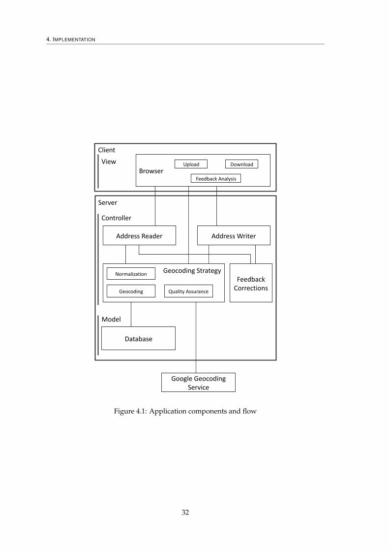
4. IMPLEMENTATION
Database
Client
Server
Google Geocoding Service
View
Controller
Model
Browser
Address Reader Address Writer
Geocoding Strategy
Geocoding Quality Assurance
Normalization
Feedback Analysis
Feedback Corrections
Upload Download
Figure 4.1: Application components and flow
32
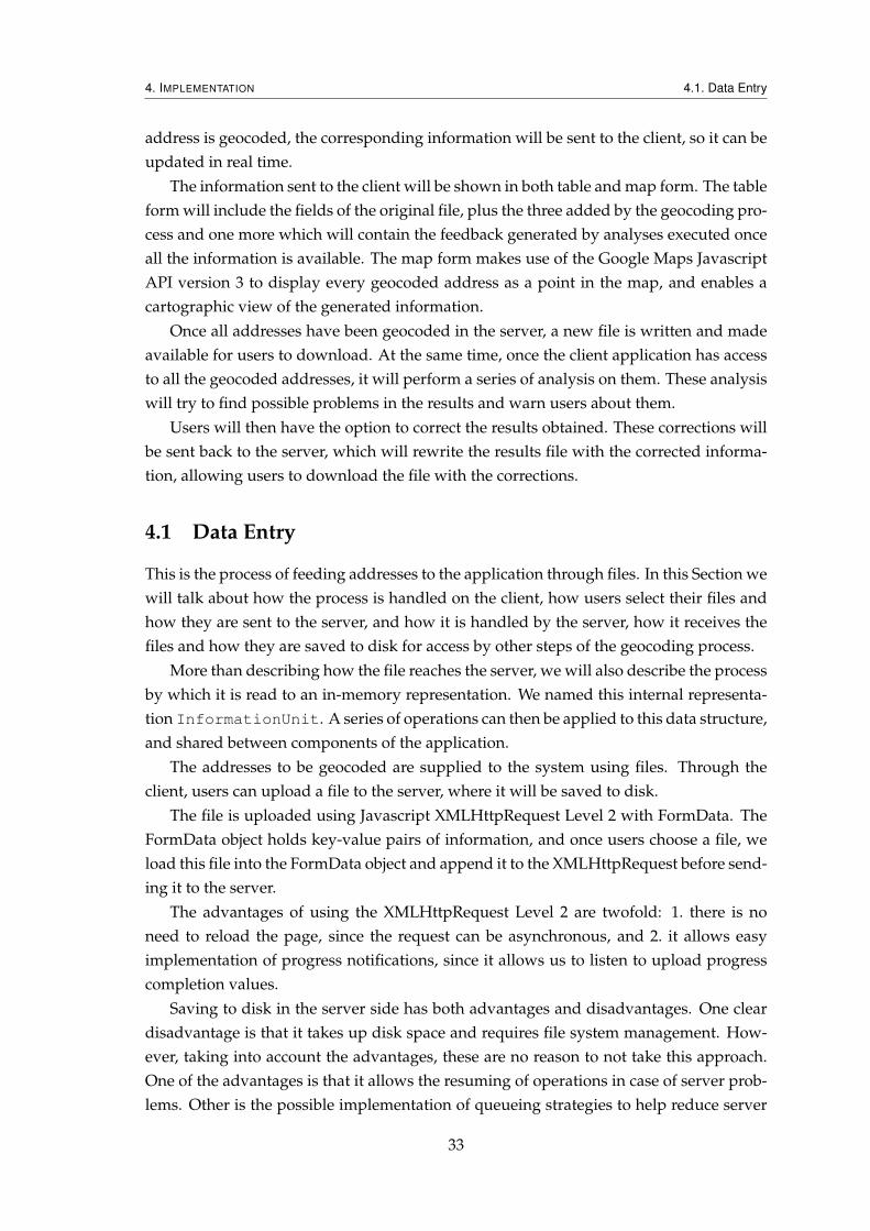
4. IMPLEMENTATION 4.1. Data Entry
address is geocoded, the corresponding information will be sent to the client, so it can beupdated in real time.
The information sent to the client will be shown in both table and map form. The tableform will include the fields of the original file, plus the three added by the geocoding pro-cess and one more which will contain the feedback generated by analyses executed onceall the information is available. The map form makes use of the Google Maps JavascriptAPI version 3 to display every geocoded address as a point in the map, and enables acartographic view of the generated information.
Once all addresses have been geocoded in the server, a new file is written and madeavailable for users to download. At the same time, once the client application has accessto all the geocoded addresses, it will perform a series of analysis on them. These analysiswill try to find possible problems in the results and warn users about them.
Users will then have the option to correct the results obtained. These corrections willbe sent back to the server, which will rewrite the results file with the corrected informa-tion, allowing users to download the file with the corrections.
4.1 Data Entry
This is the process of feeding addresses to the application through files. In this Section wewill talk about how the process is handled on the client, how users select their files andhow they are sent to the server, and how it is handled by the server, how it receives thefiles and how they are saved to disk for access by other steps of the geocoding process.
More than describing how the file reaches the server, we will also describe the processby which it is read to an in-memory representation. We named this internal representa-tion InformationUnit. A series of operations can then be applied to this data structure,and shared between components of the application.
The addresses to be geocoded are supplied to the system using files. Through theclient, users can upload a file to the server, where it will be saved to disk.
The file is uploaded using Javascript XMLHttpRequest Level 2 with FormData. TheFormData object holds key-value pairs of information, and once users choose a file, weload this file into the FormData object and append it to the XMLHttpRequest before send-ing it to the server.
The advantages of using the XMLHttpRequest Level 2 are twofold: 1. there is noneed to reload the page, since the request can be asynchronous, and 2. it allows easyimplementation of progress notifications, since it allows us to listen to upload progresscompletion values.
Saving to disk in the server side has both advantages and disadvantages. One cleardisadvantage is that it takes up disk space and requires file system management. How-ever, taking into account the advantages, these are no reason to not take this approach.One of the advantages is that it allows the resuming of operations in case of server prob-lems. Other is the possible implementation of queueing strategies to help reduce server
33
4. IMPLEMENTATION 4.1. Data Entry
load on peak times without increasing the burden on the memory used.
The advantages mentioned were not implemented, since they were deemed unneces-sary for the purposes of this project. However, the way is paved so that implementingthem requires minimum effort.
When saving files to disk it may occur that two files with the same name will beuploaded, and the last one will override the other. To avoid this, the server first checksif a file with that same name already exists, and while it does exist, it will try to create afile with a number between parentheses appended to it. For example, if the user uploadsa file with the name filename and it already exists, the server will try filename (2),filename (3), etc. until an available name is found. After the file is successfully savedto disk, the name with which it was saved is sent back to the client application.
Now that the client has the file name, it needs to open a WebSocket connection tothe server and send a message to continue the process. The message sent has the formatgeocode <filename>, where filename denotes the name of the file uploaded. Thisis not the name with which it was sent, but the one returned by the server.
The reason for this intermediate step has to do with the aforementioned reason forsaving files to disk, to allow implementation of queueing strategies. Creating the con-nection and sending the message allows the server to, for example, reply back with anegative answer, indicating with it the expected delay until the file can be geocoded,which the client can wait for before retrying.
As soon as the file is saved, and the geocoding request is received through the Web-Socket connection, we proceed to reading it. The contents of the file are translated intoan in-memory representation with the objective of abstracting file-type specifics. Thisabstraction, which we called InformationUnit, simplifies code. With it in place onlyfile readers and file writers need to be aware of file types, every other part of the systemsimply deals with this data structure.
This structure is an abstraction for an ordered list of information units read from thefile. An information unit is a single unit of information which makes sense on its own.For the case of a CSV, an information unit would be a row, for the cases of KML and GML,it would be a node. Each information unit is accompanied with an integer that denotesthe order by which it was read. The first unit read will have the number 1, the second thenumber 2, and so on. This is useful to preserve data order when writing the results fileand essential for the corrections which will be described in the following section. Alsoworth mentioning is that this structure only exists in-between the reading and writing ofa file. Once a file is written, the in-memory representation is discarded, and to re-acquireit is necessary to read the file once again.
There are two interfaces which declare how these information units should be readand written from file. A Java class implementing the InformationExtractor interfacecan be associated with a file type and loaded into the system to read the information fromfiles. In the same way, a Java class implementing the InformationDispatcher inter-face can be associated with a file type and loaded into the system to write information to
34

4. IMPLEMENTATION 4.1. Data Entry
files.However, reading and understanding the contents of a file takes substantial effort.
The way files are written and how the data within them is organized can vary even be-tween files of the same type.
Files written in CSV are one example of this. Even though the specification [CSV13]says that values must be separated by a comma, Microsoft Excel uses a semicolon. Toallow this kind of deviations, we chose to require a configuration file for every file typethe system supports.
Along with the information on how to correctly parse and read the file, file configu-rations are allowed to have extra information. Once again using CSV files as example,the data is normally distributed among various columns in no particular order, whichhinders the ability of the system to understand the information contained in the file.
At this point in the process, the information needed from the files is the address togeocode. The configuration files can specify rules which instruct the program on how tocorrectly read and understand the information contained in the file.
In most cases these rules are very simple. There are six fields which can be specified:street, locality, administrative areas level one, two and three, and country. Aside fromthe street, every field accepts an integer as access rule, which is to say that it directlycorresponds to one field in the information unit. Currently, only access by position isimplemented. Access by name was though of, but it was not finalized and is not fullysupported. An example of a valid CSV configuration file is in Listing 4.4, in the FileConfigurations paragraph of Section Server Configuration.
The street field is more complex than the others because it needs both the street nameand the door number to be complete. This choice was made based on the expected useof the system. The purpose of our solution is to geocode addresses with accuracy onthe house (e.g. the Google ROOFTOP classification), and as such it does not make senseto allow a street name without a door number. The other fields are optional to allowomissions on the matching. This way, an organization which deals with addresses ina specific country does not need to add that information to the database or to the files,and is implicitly matched, which is to say that, if neither the source file nor the databasehave information on (for example) the country, the field will always generate a positivematch. However, if one of the two does have that information, then it will be required tobe present in both for a match to occur.
Due to this, instead of simply accepting a position, the address field accepts an arrayof both integers and strings. The integers are indexes for the file columns, starting at 0,and the strings are characters which need to be put before or after the columns of the filefor the information to make sense. For example, think of the information in Table 4.1 andthe rule [0, " ", 1, ".", 2, ".", 3, ".", 4, "", 5]. The results would be:
1. Avenida D. João II 1.3.2.1A
2. Avenida D. João II 1.7.2.1
35
4. IMPLEMENTATION 4.2. Geocoding Process
STREET NAME NUMBER 1 NUMBER 2 NUMBER 3 NUMBER 4 LETTER
Avenida D. João II 1 3 2 1 AAvenida D. João II 1 7 2 1Avenida D. João II 1 16 5 F
Table 4.1: Example CSV file with addresses
3. Avenida D. João II 1.16.5.F
4.2 Geocoding Process
In the context of this application and in order to have a quality result, geocoding of oneaddress my need to be performed more than once. This need will depend on the config-urations loaded when the server was started. By default, each address will be geocodedone to two times.
The first geocoding attempt is done against the internal database of the system. If oneand only match is found the geocoding process of the address terminates here and theanswer is saved for posterior writing.
The second geocoding attempt is executed if and only if the first attempt did not endwith a valid result. In such case a request is sent to the Google Geocoding Service. Theresults can be composed by one or more pairs of coordinates and, if there is only one, thatis chosen as a valid result, if more than one are present, the first one is chosen. When theservice does not return any result, or if for some reason we are unable to access the serviceor its results, the geocoding of the address fails, and no coordinates nor confidence valuewill be provided for the address.
Every time an address geocodes successfully, the coordinates and confidence resultsare saved together with the information obtained from the file, in the respective informa-tion unit, as additional fields.
Geocoding huge files of addresses is a time consuming task. To help give the user asense of progress, every time an address is geocoded, more than saving the informationfor posterior writing, we will also immediately send this information over to the clientapplication through a WebSocket connection, which was previously created by the client.The client application will then be able to display and act upon it.
The message follows the format geocoded <json object>, where json object
is the json representation of the whole information unit pertaining to the geocoded ad-dress, plus four additional fields:
• $_address The formatted, textual address which is used to refer to the associatedlocation;
• $_latitude The latitude coordinate of the geocoded address;
• $_longitude The longitude coordinate of the geocoded address;
36

4. IMPLEMENTATION 4.2. Geocoding Process
• $_confidence The confidence associated with the result.
4.2.1 Geocoding with the Database
As mentioned in the Introduction, before an address can be matched to its coordinates, itneeds to go through the normalization step.
Implementing an address normalizer is nowhere near trivial, a whole thesis couldbe written on the subject. As such we did not attempt to write one, instead the systemmakes available extensibility hooks (see Section 4.5, Extensibility) which enable systemadministrators to provide other normalizers.
We planned on using an address normalizer which is being developed in the organi-zation. However, the state of this normalizer at the time of writing is yet far from usablefor our purposes, and as such it is not yet included with the system.
With this in mind we did implement a very simple address normalizer which is bun-dled with the system. This normalizer is in no way complete and is not recommendedfor production use, but its inclusion was necessary, both for proving that the normalizerhook is indeed working as intended and to enable a wider range of tests of the system asa whole.
Our very simple normalizer executes five operations on any given addresses:
• Removal of double white space characters;
• Converts every letter to its lower-case counterpart;
• Replaces single letters (technically, any characters) with any other combination ofletters, as defined by the file in config/replacement_characters.js;
• Replaces words as defined by the file in config/replacement_words;
• Removes stop words as defined by the file in config/stopwords.js.
The character replacement step is used to replace some letters with others, for exam-ple, reducing many letters with diacritics to their common non-diacritic root.
Replacement of words is useful for replacing full words with their equivalent forms,such as changing St. to Street.
Stopwords are words which do not add meaning to a phrase or address, such asconjunctions (and) or prepositions (of, in, on). As these appear in many addresses, andare sometimes omitted, they are removed from normalized addresses.
For a more concrete example of the execution of these operations, take a look at Figure4.2, where the address R Pedro e Inês 17 is normalized to rua pedro ines 17.
With the address and its components now normalized, it is now possible to match theaddress to the information on the database. The database is structured in three tables, asshown in Figure 4.3.
37
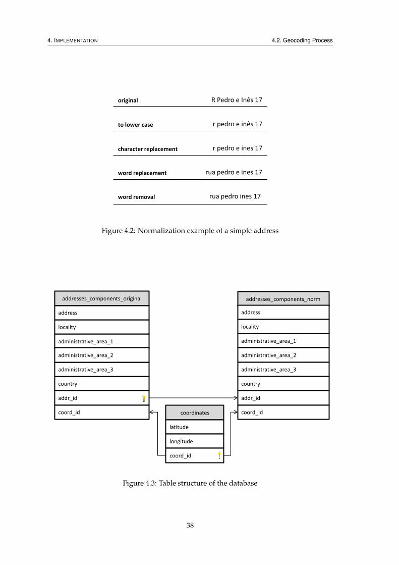
4. IMPLEMENTATION 4.2. Geocoding Process
R Pedro e Inês 17
r pedro e inês 17
r pedro e ines 17
rua pedro e ines 17
rua pedro ines 17
original
to lower case
character replacement
word replacement
word removal
Figure 4.2: Normalization example of a simple address
addresses_components_norm
address
locality
administrative_area_1
administrative_area_2
administrative_area_3
country
addr_id
coord_id coordinates
latitude
longitude
coord_id
addresses_components_original
administrative_area_1
locality
country
address
administrative_area_3
administrative_area_2
addr_id
coord_id
Figure 4.3: Table structure of the database
38

4. IMPLEMENTATION 4.2. Geocoding Process
The coordinates table contains the latitude and longitude pairs for every addressin the database. The coord_id column is the primary key.
The addresses_components_original table contains the original addresses givento the database, these are not normalized, and will be necessary if the normalizer for thesystem is ever changed. The addr_id column is the primary key, and the coord_id
column is a foreign key which references the column coord_id of the coordinates
table.The addresses_components_norm table contains the same columns as the previ-
ous table, but unlike it, the every address field is normalized according to the addressnormalizer currently in use. The addr_id column is a foreign key which references thecolumn addr_id of the addresses_components_original, and the coord_id col-umn is another foreign key which references the column coord_id of the coordinatestable.
The need for two tables with almost the same data stems from the fact that addressesneed to be normalized. If it were not included, the addresses_components_originaltable would suffice, but since it is, we need the addresses_components_norm tableto hold the normalized form of all addresses.
Most of the time, only the table with the normalized addresses will be consulted, andin fact, it is the only one needed for the proper functioning of the system, which raisesthe question of why should we maintain the table with the original addresses. As willbe mentioned in the Extensibility section, normalizers can be changed in between serverrestarts, if the administrator so desires, which raises some problems with this approach.
When the normalizer changes, the results of the normalization of addresses will alsochange. However, the information on the database does not change to accommodatethese, and it will stop providing results, since the addresses normalized with the newnormalizer will not match most or all the addresses normalized with the old normalizer.
There is, then, a need to re-normalize the addresses in the database. This is impossibleto do if done with the information taken from the normalized table, since in that table,original information may, and most probably will, be lost. For this re-normalization tobe possible, we need access to the original information, not modified by the previousnormalization process, which is why the original table is present.
The query used to search the database is shown in Listing 4.1, in JDBC syntax, mean-ing that the interrogation points are arguments to be set at runtime.
Listing 4.1: SQL query for address matching1 SELECT
2 o.address, o.locality, o.administrative_area_1, o.administrative_area_2,
3 o.administrative_area_3, o.country, c.latitude, c.longitude
4 FROM
5 addresses_components_original as o INNER JOIN
6 addresses_components_norm as n ON(o.addr_id = n.addr_id) INNER JOIN
7 coordinates as c ON(n.coord_id = c.coord_id)
8 WHERE
39

4. IMPLEMENTATION 4.2. Geocoding Process
9 (n.address = ? OR (n.address IS NULL AND ? IS NULL)) AND
10 (n.locality = ? OR (n.locality IS NULL AND ? IS NULL)) AND
11 (n.administrative_area_1 = ? OR
12 (n.administrative_area_1 IS NULL AND ? IS NULL)) AND
13 (n.administrative_area_2 = ? OR
14 (n.administrative_area_2 IS NULL AND ? IS NULL)) AND
15 (n.administrative_area_3 = ? OR
16 (n.administrative_area_3 IS NULL AND ? IS NULL)) AND
17 (n.country = ? OR (n.country IS NULL AND ? IS NULL))
The three tables are joined, the two with the address components using their addr_idand the table with the coordinates using coord_id. From the resulting table we retrievethe addresses components and the latitude and longitude of the associated coordinates.Addresses components are only selected if all their components match the ones given bythe normalization process.
The WHERE clauses are more convoluted than expected. The problem here is that, bythe SQL standard, comparisons with NULL, such as n.address = NULL, always returnfalse. What this means in practice is that when one of columns is NULL in the databaseor one of the fields in the address is not present, the comparison will always fail, evenif it should otherwise pass. To compare with NULL in SQL one should instead use theform IS NULL. This creates a problem because now, when one of the fields of the addressbeing matched does not exist, there is the need to generate the query using the is-operatorinstead of equals-operator, which is impossible to do with Java’s SQL Statements withouthaving to rewrite the query.
One solution to this problem, which does not require the runtime modification of thequery, is to add a second condition to the where clause. The first condition, n.address= ? will match if both sides are non-null and the strings are equal. The second con-dition, n.address IS NULL AND ? IS NULL matches when both the column in thedatabase is NULL and the field from the address is missing.
This query returns either one or zero addresses. If a result is retrieved from thedatabase, then it is selected as the correct geocodification of the given address, and givena confidence value of Novabase to indicate that it came from the database. When noresults are retrieved from the database, this geocoding step fails and execution passes tothe next geocoding service, which is the Google Geocoding Service, for a new attempt atgeocoding.
4.2.2 Geocoding with the Google Geocoding Service
When geocoding with the database fails we fall back to the Google Geocoding Service.This web service allows us to send an address to Google and get back some informationon the address, including latitude, longitude and method of calculation.
The answer can be retrieved in either XML or JSON formats, and since we are alreadyusing JSON in other parts of the application, that is the format in which we request our
40

4. IMPLEMENTATION 4.3. Data Output
responses.Once the response is obtained, we check for the number of results returned. If there
are no results, it means the service was unable to find a match or some communicationerror occurred, in which case the geocoding process ends without any viable solution.
When one match is found, the process ends with it as the valid result, just as it wouldif it were a database match. However, the Google Geocoding Service may return morethan one valid result. When this happens the first one is chosen as the solution, and thegeocoding finishes successfully.
The chosen solution will carry the latitude and longitude information as it came inthe service response. Confidence information, however, comes in GIS terms, which maybe difficult to understand to our target users. As such, these terms are mapped into morefriendly values:
1. ROOFTOP : Exact;
2. RANGE_INTERPOLATED : Street;
3. GEOMETRIC_CENTER : Region;
4. APPROXIMATE : Rough Approximation.
4.3 Data Output
Once every address has been geocoded we can proceed to writing the file for users todownload. The writing process is similar to reading. The information units, updatedin the geocoding step, will be fed to instances of InformationDispatchers. Thesedispatchers will then write the information to the appropriate file.
By definition, the type of the file being written will be the same as the one that wasread. This means that if the input file was in the CSV format, the output file will also bein CSV format.
After the file is written and saved to disk, a message is sent to the client applica-tion using the previously established WebSocket connection. The message has the formatfinish <relative path>, where relative path is the path to the file which con-tains the geocoded information. The interface will then be updated to allow the down-load of this file.
The logic of both the server and the client applications are ready to allow the rewrit-ing of the results file into a file of another type. To start the operation the client needsto send a WebSocket message with the format rewrite <filename>.<extension>
where filename is the name of the results file which was made available before andextension is the extension of the desired file type.
Upon receiving that message the server will build a list of files which contain theresults of the geocoding process and have the same name. This is easily done becausegeocoded files are all stored within the same folder, and kept apart from non-geocoded
41

4. IMPLEMENTATION 4.4. Feedback Analysis
files, which are stored in another folder. Building the list is a matter of looking into thedirectory with the geocoded files and look for files with the same name, while ignoringthe extension.
Once this list is built, we proceed into trying to read them, which is to say, we willlook into every file and try to find a matching InformationExtractor which is ableto read the file. With the default configuration, it is impossible for this look-up to fail.Because the results file is of the same type as the file originally provided by the user,which we were able to read before, the geocoded file will necessarily have the same filetype as the originally uploaded file, and thus be readable.
After we obtain the file containing the results with the whole information and anappropriate InformationExtractor, the algorithm proceeds with trying to find anappropriate InformationDispatcher for the file type indicated by the extension. Ifno Dispatcher is found, this process fails and an error message is sent to the client appli-cation. Otherwise, the Dispatcher is created and the process continues.
Having a source file, an appropriate Extractor, a target file and an appropriate Dis-patcher, writing the new file is a matter of reading all the information units containedin the source file and sending them to the Dispatcher for writing. When the process iscomplete and the file is saved to disk, the server sends a message to the client informingit of this. this message has the same format as the one sent when the first results file wasmade available.
We mentioned that an error can occur if the user specifies a file type which the serveris not ready to handle. In theory, if the interface were complete, this would not happen.The plan was for, when creating the page, to use JSP to inject into the page the extensionthe server supports, and the interface only allowing those to be selected. However, due tolack of time, this was not implemented and, in fact, the client application has no access tothese file types and cannot request a rewrite of a file through the interface, only throughthe browser’s console. This is one of the features which must be implemented in thefuture.
4.4 Feedback Analysis
When the geocoded information arrives on the client side of the application, it is immedi-ately displayed both on a table and on a map. Rows in the table can be selected, and thiswill highlight the corresponding marker which locates the address in the map. Clickingin any marker in the map will bring up a window with the row information associatedwith it. These visualizations can be thought of as an ad-hoc analysis mechanism, but thisexperience can also be improved in the future.
Once all the addresses have been geocoded, the client application immediately runstwo different analysis: 1. same-location analysis and 2. out-of-cluster analysis. Both anal-yses are based on our findings of the behaviours of mainstream geocoding services, andare designed by us to handle those specific scenarios. They are explained further in this
42
4. IMPLEMENTATION 4.4. Feedback Analysis
section.The objective of these analyses is to hint to users that, although addresses have been
geocoded, there may be some which were assigned incorrect locations. The applicationdoes not require that users act on the results of the analyses, even more so because theremay be some false-positives. Thus, users are warned about results which may be wrong,not about results which are certainly wrong.
When the users detect a wrong result, whether it was caught in the analyses or not,they have the option to correct it. This correction can be done in one of two ways.
The first correction method allows the user to move the location assigned to the ad-dress to a different one. This is done by making the respective map marker draggable sothat the user can place it in the correct location. Once this modification is saved, the newlocation is preserved in a list of modifications, to be sent to the server when the correctionprocess has ended. This correction can be cancelled at any time during the operation (butnot after it is concluded), which re-locates the marker to its original position, before anyuser movements.
The second correction allows the users to specify a new address to geocode, insteadof current one, which will be directly saved to the list of corrections.
Once the users finish the corrections, they can send those back to the server. Theyare sent to the server through a WebSocket connection, each in its own message. Themessages have the following format:
• Coordinates correction correct coordinates <id> <new latitude> <new
longitude>;
• Address correction correct address <id> <new address>.
The new fields carry the corrected information, the id field is the identification num-ber given to the information units created when the original user file was read.
After they arrive, the server will read the results file, the one that had previously beenmade available for users to download, and load the information units from it. This iswhy the identification number is so important. The order of the information units in theread file must be exactly the same as the one in the written file. If this is not the case, theinformation units read from the results file, although correct, may appear in a differentorder, and the corrections will affect the wrong information units, which will result in thenew file being wrong.
The re-location correction directly changes the coordinates of the results. The latitudeand longitude which were there before will be overwritten with the new ones.
The address corrections, on the other hand, are more complex. They need to triggernew geocoding requests which will be handled exactly as described in the previous sec-tion, but with the new address instead of the previous one. As in the previous case, thelatitude, longitude and confidence will be overwritten.
After all the changes are done, the old file will be deleted and the new one will bewritten with the same name, effectively replacing the old file.
43

4. IMPLEMENTATION 4.4. Feedback Analysis
Same-Point Analysis One of the common outcomes observed while testing geocodersresponses to the difficult set of addresses described in State of the Art was that variousaddresses would point to the exact same location. It happened commonly when thegeocoder recognized the street, or part of it, but not the door number. It would thendisregard the door number, and every address which had the same street name would begeocoded to the same location.
This analysis takes hold on that observed fact and that, in the general case, two dif-ferent addresses are not meant to represent the same physical location, or in other words,that if two different addresses are geocoded to the same exact location, we can assumewith a high probability that at least one of the addresses has been erroneously geocoded.
Using that prior information, the previously obtained geographic coordinates arecompared to each other, and if any two or more different results have the same coor-dinates, they are marked with a warning. This warning indicates how many differentaddresses are located in that same location, and selecting one of those addresses will alsoselect any addresses in that location, so that they are easier to identify in the table view.
The first step is to create a data structure to help us identify these duplicate points.The data structure chosen is made up of Javascript Maps (not a cartographic map). It is amap which maps latitude values to a map which maps longitude values to the geocodedinformation, or, using a programming example, the following format:
1 \\ {} denotes a Map and [] an Array
2 \\ x : y denotes a Mapping, where ’x’ is the Key and ’y’ the Value
3
4 { latitude : { longitude : [ pointer to the data ] } }
The first map uses the latitude value of the coordinates as a key. While examiningone point, we check for the existence of its latitude as a key in the map. If the key is notpresent, it will be added with an empty map as its value, if it is, the presence of a mapalready associated with the key is assumed and we move to step two.
In the second step the longitude of the point is examined. Once again, it may alreadybe present on the map or not. If it is not present, it will be created, and the value willbe an array containing a single element: the information associated with the point beinganalysed. If it is already present, the value associated with the longitude will be changed,the information associated with this point will be added as an element of the previouslymentioned array.
In practice, what this means is that we have every unique pair of latitude and lon-gitude as the map and sub-maps, and the values of the sub-maps are the informationassociated with those points.
After every point is examined and placed in the map, discovering the repeated co-ordinates is a matter of checking the arrays in the sub-maps. On one hand, if the arrayhas a single element, then it is the only single location at those coordinates, on the otherhand, if it has more than one element, all the elements contained in it have the samecoordinates, and a warning should be issued for them.
44
4. IMPLEMENTATION 4.4. Feedback Analysis
It is important to notice that the elements in the array are not copies of the originalinformation. That information is stored in a separate structure, and the elements in thearray will simply point to it, there is no duplication of information in the process.
Out-of-Cluster Analysis This analysis takes hold on extra information known aboutthe data to be uploaded into the knowledge base. In many cases, the locations that areto be geocoded are not isolated points seemingly randomly distributed. More often thannot, they will all be located within some bounds. From this, it can be inferred that if somelocations are geocoded too far away from the bulk of the locations, then those are, mostprobably, erroneous results.
This analysis uses that information and tries to locate results which seem to be abnor-mally distant from others, marking them and warning the user about them, indicating apossible problem with the results.
The algorithm for this one is much heavier and complex than the Same-Point Analy-sis. First, for every coordinates available we build a bounding box with some predefinedlength, such that the coordinates point to the center of the box. Then the following algo-rithm is executed.
The size of the list of bounding boxes is saved for subsequent use. For every boundingbox, we check whether it intersects with any other bounding box which follows it inthe list. If any two or more intersect then a new bounding box is created, which willcontain all of the bounding boxes that were found to intersect. The intersecting, smallerbounding boxes are removed from the list, and the newly created one is added. Afterthe list of bounding boxes has been exhausted, the initial size of the list is compared tothe actual size. If the sizes are different it means new and larger bounding boxes werecreated, which in turn means that new intersections which were not checked may nowoccur. The algorithm runs once more. If the sizes are the same, nothing has changed, andno more intersections are possible, which ends the process.
Each bounding box maintains information on which coordinates and associated infor-mation duel within it. If the number of elements within a bounding box is smaller thansome predefined threshold, then the whole collection of elements if regarded as possiblyerroneously geocoded, and this is transmitted to users.
Two predefined values were mentioned in the algorithm. One was the length of thebounding box. In the program this quantity needs to be saved as quantities of latitudeand longitude, and need to be set manually because at different points in the globe oneunit of latitude and longitude will translate to different distances. By default the programuses units of latitude valuing 0.004495 and of longitude valuing 0.005835, both ofwhich will approximate half a kilometre at 40o.
The second predefined value is the threshold at which a number of isolated pointsis considered suspicious. For example, if the threshold value was 4, then a boundingbox containing four or less locations within it would be marked as possibly erroneouslygeocoded. However, a single, absolute value for the threshold may prove itself not very
45

4. IMPLEMENTATION 4.5. Extensibility
useful. For a file with 1.000.000 addresses, 100 isolated results may be suspicious, but fora file with 300 addresses, it is not. To allow for this kind of adaptation, a third predefinedvalue may be specified, a boolean value which tells the program if the threshold valueshould be interpreted as a percentage or as an absolute value. If it is set to false, thebehaviour will be the previously mentioned, but if it is set to true the value will beinterpreted as a percentage. For example, if the program is set to interpret the value asa percentage, and the threshold value is 1, for a file with 1.000.000 addresses the actualthreshold value will be 1.000, and for a file with 300 addresses, it will be 3.
4.5 Extensibility
Extensibility and flexibility have been the focus of much of the development of this sys-tem. Different users have different needs. Trying to answer every one of those needswould be unrealistic. Instead, we provide the baseline functionality, that which is mostneeded, and leave open a series of extension points that application administrators canuse to satisfy specific needs.
Configuring the system so it behaves slightly differently can be achieved solely bymodifying configuration files, which are written in JSON. This format was chosen toavoid context switches while implementing and maintaining the system, since the resultsof geocoding requests, from the Google Geocoding Service, are also received in JSON for-mat. The two files contained the default configuration of the application can be consultedin the Appendix.
For more advanced control or added functionality, Java classes must be created andadded both to the class path and to the configuration files.
4.5.1 Database Configuration
Database connections are achieved through the use of JDBCs. The default database isPostgreSQL version 9.2 and the default JDBC is PostgreSQL JDBC4 version 9.2.
System administrators who need to change the database only need to include theproper JDBC for the database they chose in the classpath and change some values in theconfiguration file located at config/database.js. The fields required in the file are:
• driverClassName The class name for the Driver in question, which needs to bein the class path to be loaded;
• subprotocol The subprotocol to be used in the connection;
• hostname The name of the host computer holding the database;
• port The port the server should use to connect to the mentioned computer;
• databaseName The name of the database to connect to;
46

4. IMPLEMENTATION 4.5. Extensibility
• username The user name to use in the login to the database;
• password The password to use in the login to the database.
At server start-up, this file will be read, and, when needed, the system will use theinformation read from it to connect to the database. The default configuration (withoutusername or password) is shown in Listing 4.2.
Listing 4.2: Default Database Configuration1 "driverClassName" : "org.postgresql.Driver",
2 "subprotocol" : "postgresql",
3 "hostname" : "localhost",
4 "port" : 5432,
5 "databaseName" : "novabase_geocoder",
At the start of development, the configuration file additionally allowed the writingof some SQL commands. These commands would be executed in response to prede-fined events, such as server initialization or finalization. The objective was to allow thedatabase to have an arbitrary structure defined by the system administrator. Most com-mands could be defined that way, but there were some which could not.
The defined syntax would accept commands with one or more queries to run sequen-tially. However, some queries needed the results of previous queries to function, as wasthe case with the command to add coordinates to the database, which worked as follows:
1. Query the coordinates table for a pair of coordinates that are equal to the onescurrently being added;
2. If the result set of the previous query is empty, add the coordinates, else do nothing.
This dependency of query number 2 on the results of query number 1 would require achange in the syntax of command definitions in the configuration file, introducing muchmore complexity than was our intention. We did not wish to insert complex logic intothe JSON files, and consequently chose not to include it.
Even with this limitation, this system allowed some degree of extensibility on thedatabase queries. However, as the project evolved, changes which further complicatedthis behaviour were made. One such difficulty was that the database definition changedand became more complex, which had the consequence of further complicating the SQLneeded to query the database. To allow SQL into the configuration files in those newcircumstances, we would need to create a Domain Specific Language (DSL), and althoughit would be a very simple DSL, it would not be trivial to implement. The DSL idea wasdiscarded as being out of the scope of the project and SQL commands were removed fromone of the extensibility targets, to be implemented back in further stages of the project.
Nevertheless, as long as the database structure remains as described in the earlierSections of this Chapter, it is still possible to change databases using the configurationfile.
47

4. IMPLEMENTATION 4.5. Extensibility
4.5.2 Server Configuration
Extending the features of the server can be realized through the inclusion of Java classesto the class path, however, to make these inclusions known to the system, they need tobe explicitly set on the configuration file located at config/configuration.js.
This file will be loaded at server start-up, and if it does not exist or it cannot be parsed,the server will default to a hard-coded configuration, which is exactly the same as theconfiguration provided by default on the file.
Information Extractors and Dispatchers These are the classes responsible for readingand writing files. An Extractor is a class that implements the InformationExtractorinterface and a Dispatcher is a class that implements the InformationDispatcher
interface. The default system configuration has one InformationExtractor and threeInformationDispatchers:
• CsvInformationExtractor Enables reading from CSV files
• CsvInformationDispatcher Enables writing to CSV files
• KmlInformationDispatcher Enables writing to KML files
• GmlInformationDispatcher Enables writing to GML files
The syntax for declaring extractors and dispatchers is the same, and can be seen inListing 4.3.
Listing 4.3: Configuration example for Extractors and Dispatchers
1 "extractors" : {
2 "text/csv" :
3 "com.novabase.geocoder.files.csv.CsvInformationExtractor",
4 "application/vnd.ms-excel" :
5 "com.novabase.geocoder.files.csv.CsvInformationExtractor"
6 },
7 "dispatchers" : {
8 "text/csv" :
9 "com.novabase.geocoder.files.csv.CsvInformationDispatcher",
10 "application/vnd.ms-excel" :
11 "com.novabase.geocoder.files.csv.CsvInformationDispatcher",
12 "application/vnd.google-earth.kml+xml" :
13 "com.novabase.geocoder.files.kml.KmlInformationDispatcher",
14 "application/gml+xml" :
15 "com.novabase.geocoder.files.gml.GmlInformationDispatcher"
16 }
There is a map for the extractors and another for the dispatchers. Each key in themap is a MIME-type, and each value is class path. This format limits the number ofextractors and dispatchers for each MIME-type to one. The format could be changed to
48

4. IMPLEMENTATION 4.5. Extensibility
allow declaring more than one by turning the values into an array of classpaths, but thereis no need, since only one will be used by system.
It is, however, possible to assign the same class to more than one MIME-type, whichis what happens to the types text/css and application/vnd.ms-excel (the lastone being a specific case of the former). Both types are handled by the same class, anddifferences are supported through the use of file configurations, which will be describedbelow.
File Configurations File configurations define how files should be read. There are twoways to specify these configurations. The first one is on the server configuration file andallows configuration on a file type basis, the second one is to define per-file configurationfiles and is done on a per file basis. This last one is a self contained JSON file with thesame format as the object in the server configuration, but which needs to be located onthe same folder as the files they specify; additionally, they need to have the exact samename (devoid extension) as the data file. For example, if we wanted to define a configu-ration file specific for the file data.csv the configuration file would need to be nameddata.js and be located on the same folder as the source file.
All file configurations should be placed in an array with the name files. Each po-sition of the array will be a file configuration for some MIME-type. If more than oneconfiguration is defined for the same MIME-type, only the last one will take effect. Anexample of a file configuration is in Listing 4.4.
Listing 4.4: Configuration example for File Configurations
1 "files" : [
2 {
3 "mimeType" : "application/vnd.ms-excel",
4 "className" : "com.novabase.geocoder.files.csv.CsvConfiguration",
5 "properties" : {
6 "fieldDelimiter" : "",
7 "fieldSeparator" : ";",
8 "lineSeparator" : "\r\n",
9 "address" : [1],
10 "administrative_area_3" : 3,
11 "country" : 4,
12 "latitude" : -3,
13 "longitude" : -2,
14 "confidence" : -1
15 }
16 }
17 ]
Only the first two entries of the object need to be present. The mime-type specifiesthe MIME-type to which the configuration should apply, and the className to whichclass.
The properties may or not be present, and it specifies entries which are specific to
49

4. IMPLEMENTATION 4.5. Extensibility
each configuration. The example above defines the syntax used by CSV files written inMicrosoft Excel, and the positions of geocoding information. In particular, the address,administrative_area_3 and country properties gives instructions on how to readthe full address, as was described in Section 4.1. The other three, latitude, longitude andconfidence, initially were prepared to have that same functionality, but it was eventuallydeemed unnecessary and dropped. However, the array notation in the configuration wasmaintained. Negative indexes denote a position from end to start, instead of from startto end.
Depending on the context classes implementing InformationExtractormay choseto ignore some of the defined properties. As an example, the class responsible for readingCSV files ignores the properties latitude, longitude and confidencewhen readinguser files, but acknowledges them when using files created by the system itself (whichare assumed to be geocoded).
Geocoding Services New geocoding services are implemented as Java classes whichextend the GeocodingService class. Implementations only need to write one method,geocode, which accepts a GeocodingRequest object as its argument and returns aGeocodingResponse object. Both classes mentioned are wrappers which give access tothe underlying information unit.
Once added to the class path, they need to be declared inside geocoding strategies,which are explained below, to be used.
Geocoding Strategies Geocoding strategies define the order in which geocoding ser-vices are used, and in which cases should a response from them be accepted.
The configuration is written inside the strategy property, and it is composed ofan array of objects, which describe geocoding services. The order by which the servicesappear declared in the array is the order in which the system will query them.
Each geocoding service object needs a className property, which value should bethe fully qualified name of the class that handles the geocoding service, and three moreproperties which define its behaviour:
• accept Defines rules which instruct the strategy to accept the geocoding responseof the service. If the response is accepted, geocoding services declared after thecurrent one will not be queried;
• cont Defines rules which instruct the strategy to ignore the geocoding response ofthe service and proceed with the next service on the list;
• fail Defines rules which instruct the strategy to short-circuit the process and failthe geocoding of the address in the request. If the response is failed, geocodingservices declared after this rule is matched will not be queried.
50
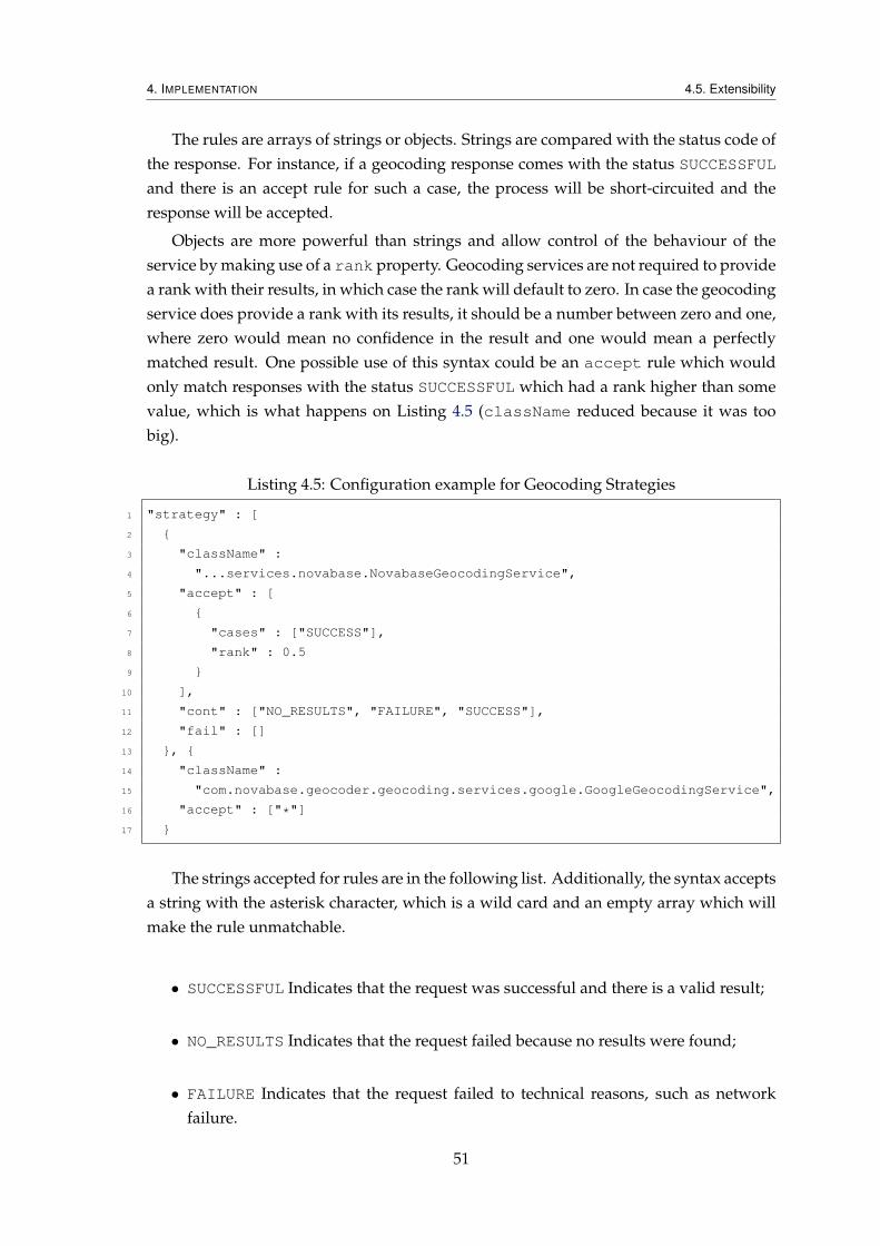
4. IMPLEMENTATION 4.5. Extensibility
The rules are arrays of strings or objects. Strings are compared with the status code ofthe response. For instance, if a geocoding response comes with the status SUCCESSFULand there is an accept rule for such a case, the process will be short-circuited and theresponse will be accepted.
Objects are more powerful than strings and allow control of the behaviour of theservice by making use of a rank property. Geocoding services are not required to providea rank with their results, in which case the rank will default to zero. In case the geocodingservice does provide a rank with its results, it should be a number between zero and one,where zero would mean no confidence in the result and one would mean a perfectlymatched result. One possible use of this syntax could be an accept rule which wouldonly match responses with the status SUCCESSFUL which had a rank higher than somevalue, which is what happens on Listing 4.5 (className reduced because it was toobig).
Listing 4.5: Configuration example for Geocoding Strategies
1 "strategy" : [
2 {
3 "className" :
4 "...services.novabase.NovabaseGeocodingService",
5 "accept" : [
6 {
7 "cases" : ["SUCCESS"],
8 "rank" : 0.5
9 }
10 ],
11 "cont" : ["NO_RESULTS", "FAILURE", "SUCCESS"],
12 "fail" : []
13 }, {
14 "className" :
15 "com.novabase.geocoder.geocoding.services.google.GoogleGeocodingService",
16 "accept" : ["*"]
17 }
The strings accepted for rules are in the following list. Additionally, the syntax acceptsa string with the asterisk character, which is a wild card and an empty array which willmake the rule unmatchable.
• SUCCESSFUL Indicates that the request was successful and there is a valid result;
• NO_RESULTS Indicates that the request failed because no results were found;
• FAILURE Indicates that the request failed to technical reasons, such as networkfailure.
51

4. IMPLEMENTATION 4.6. Server Start-up and Finalization
4.5.3 Client Configuration
As this part of the project was only thought of later in the timeline, the design of itsstructure was not correctly defined since the beginning, and extending the client requiresaltering the application source files.
Nonetheless, some aspects of the Out-of-Cluster Analysis are configurable. It is pos-sible to define the dimensions of the clusters bounding boxes, in latitude and longitudeexpressed in decimals, and how many locations need to be in a cluster for them to beconsidered valid results, either as an absolute number or as a percentage.
4.6 Server Start-up and Finalization
Start-up is what we consider to be the routines which handle server boot and initializa-tion, until it is ready to answer requests. Tomcat already automatically loads the applica-tion, but any third-party classes which the application requires need to be loaded by theapplication itself.
Due to reasons explained in section 4.5, Extensibility the server needs to do somepreparations before the application can be used. Some of the extensibility features canonly be provided and loaded through the use of Java classes.
The start-up process will search for any classes which are specified in the configura-tion files and load them into memory. Objects will be created from them as necessary.
Finalization is the opposite, the routines which clean-up the server resources untileverything is properly saved and closed.
When the server finishes execution, some clean up is required, namely of the JDBCDrivers. We connect to the database through provided JDBCs, which can come whichbuilt-in finalization routines. However, this is an optional feature, and some do notderegister themselves during server shutdown. To prevent memory leaks, we listen tothe server shutdown event and manually deregister any Drivers still connected.
4.7 Conclusion
The implementation supports every objective initially defined, with the exception of theusability target, which was dropped as soon as we noticed the lack of resources for it.
A great part of the overhead of the implementation went to the extensibility mecha-nism and the reading and writing of files, which, fortunately, were the first to be imple-mented, which allowed us to reorganize and optimize our efforts for the final application.
Despite this, there are many aspect of the application which could be improved, andeven some features that are missing, of which one is very important. These improvementsand features which should be included are described in the next Chapter.
52

5Conclusion
We have built an application which is capable of harnessing not only the results of var-ious geocoding services but also those that organizations already have on their posses-sion. The application is extensible enough to be able to fill various different needs, whichincreases its value, as it can be used by different organizations. While a the same timeimproving on the current state of the technology, by giving users the ability not only toverify but also correct the results obtained.
Mainstream geocoding services have been tested, and from those we deduced thattheir results do not have enough quality for heavy use by organizations when analysingbulk information. Results are often slightly displaced from their true locations, mightnot be obtained at all or, worse of all, be downright wrong while being accompanied bypositive confidence values.
Knowing organizations have information which could improve these results, but nomeans to use it, we strived for the creation of an application with the intention of enablingthose same organizations to make use of their information while still being able to relyon mainstream geocoding services when necessary.
The resulting application satisfies the objectives envisioned, allowing the geocodingof any number of addresses while recurring to the organization’s knowledge bases andfalling back to the mainstream geocoding services. However, much remains which canbe improved.
53

5. CONCLUSION 5.1. Future
5.1 Future
Although the application passes all the initially defined requirements, there is much thatcan be improved. These have been partitioned into two classes, features and improve-ments. There are some improvements which can be though of as features too, but theywere moved to the improvements sections due to their lower priority in comparison withthe rest.
5.1.1 Features
Client-side definition of input files For the server to be able to understand the contentsof the uploaded files, it needs to have access to the structure of the files. In CSV files,for example, this means that it needs to know which columns contain which relevantinformation. As described earlier, these are defined in files on the server side.
This approach has the harsh limitation that, if users need to upload files with a dif-ferent structure, they have to contact system administrators to change the configurationfiles.
Ideally, the client side of the application would have a feature where users would beable to specify this configuration, which would then be sent to the server with the file.This would allow the upload of files regardless of their structure.
Implementing this would require updating both the client side and the server. Theclient would have to implement the interface for the feature. The server would have toimplement the saving of the configuration file with the data file. All the posterior actionswould be able to proceed from there without changes.
Download files in alternative formats The current behaviour allows the download ofresulting files in the same format as the source files, but sometimes it is useful to trans-form the source into a different file type format. For example, uploading a CSV file anddownloading a GML file.
The server already supports this feature (assuming the appropriate Extractors andDispatchers are available), and the client can already send the event which fires thisoperation, but the interface does not yet support this action, and users can not access it.
Persistent Corrections As it is now, when users correct incorrect geocoding results,those corrections are only reflected on the results file. However, it is possible to take ad-vantage of the fact that our target base are people who know the data provided. Knowingthis, and assuming that their corrections are indeed correct, it is possible to update theknowledge base with their corrections, thus increasing its size and quality.
One additional change which could be made due to this would be the creation of anew confidence value. There is already one reserved confidence value for results whichcome from the knowledge base, but it might prove insightful to create an extra one which
54

5. CONCLUSION 5.1. Future
indicates that not only did it come from the knowledge base, but that it was manuallyinserted there by their users.
Web API Since the server already handles batch geocoding, it would be advantageousto make available a Web API. Other applications would then be able to make use of ourapplication, just as the application makes uses of other Web APIs for its results.
5.1.2 Improvements
Improved WebSocket implementation Currently, a WebSocket connection is openedwhen users upload a file and is maintained through the whole session. If, for some rea-son, the connection breaks, the application does not reconnect and the client loses itsability to talk with the server, and vice-versa.
Though not widely tested, the server structure is prepared to support loss of connec-tion and reconnection without disrupting any of his actions (although messages whichwere not sent to the client due to the broken connection are not saved for posterior up-date). Implementing this is a matter of the client re-attempting the connection after it isinitially lost.
Database extensibility It had to be left behind because it would require too much re-sources to implement correctly, but assuming the resources are available it would beimportant for the extensibility of the whole application to go back and implement thiscorrectly.
To properly allow arbitrary queries a small DSL would be required. The objectivewould be to extend the JDBC syntax to allow specific positioning of the attributes.
The JDBC syntax only allows input of variables through indexes, by placing a ? placeholder character in the query. This is not enough for our use case because the applicationdoes not know which variable to attribute to each place holder.
The idea is to expand the syntax such that it defines some names for each variable,thus allowing the DSL to use those names to specify which variable is needed at eachplace holder. An example would be the following query:
1 SELECT * FROM addresses WHERE addresses.country = ?country;
The ? syntax is preserved but expanded. In this case the parser of the DSL wouldrecognize the place holder character and read the name connected to it. This informationwould be fed to the application which would then know that the first place holder wasto be filled with information on the variable named country.
The final DSL could eventually be expanded with other features, but this would bethe behaviour necessary for the first intended implementation.
An added bonus of this DSL is that it would allow arbitrary database structures. Oncequeries become arbitrary, there would remain no need for hard-coded queries which re-quire a pre-defined, known architecture.
55

5. CONCLUSION
Automated knowledge base updates Updates to the database have to be manuallyexecuted by systems administrators. Its maintenance could be streamlined if there was ascript which could read files and update the database with its data.
The current structure of the application could be reused to implement part of thisprocess. If the database is thought of as another kind of file, then the only requirementsfor the script would be an appropriate Extractor and a database Dispatcher.
Wiser selection of results from geocoding services It was mentioned in the implemen-tation description of the algorithm for fetching results from google that, in case of multi-ple results, the first one is always the chosen one.
It would be possible to implement an algorithm which would analyse all the obtainedresults and choose the more appropriate one. Whether this is useful and reliable enoughis something that would be needed to be researched first.
Automatic calculation of kilometres to decimal latitude/longitude As mentioned be-fore, when describing how to change the size of the bounding boxes for the Out-of-Cluster Analysis, distances have to be specified as latitude and longitude in decimal for-mat. This is because in different locations, one unit of latitude or longitude correspondsto different distances. However, this change is stable for every degree, so it is possible todesign an algorithm that, knowing a location, would transform distances in kilometresto their respective latitude and longitude quantities.
This would, however, require some way of knowing the ratio from latitude/longitudeto kilometres of the specific locations.
Client configurations on separate files In its current state, the source files of the clientapplication need to be changed directly to allow for customization. The ideal way ofdoing this would be to have separate Javascript files which contained the necessary vari-ables (for configuration specific aspects of analysis) and functions (for custom analysis),which would then be included in the resources of the page, allowing our main script toload its configuration from there, to the client.
56

Bibliography
[Bat13] Batch geocode, january 2013. Visited on 27 August 2013.
[Bin13] Bing maps rest services, january 2013. Visited on 27 August 2013.
[Bul13] Bulk geocoder, january 2013. Visited on 27 August 2013.
[CC02] Tim Churches and Peter Christen. Preparation of name and address data forrecord linkage using hidden Markov models. BMC Medical Informatics andDecision Making, 16:1–16, 2002.
[CCW04] Peter Christen, Tim Churches, and Alan Willmore. A probabilistic geocodingsystem based on a national address file. In Proceedings of the 3rd AustralasianData Mining Conference, Cairns, 2004.
[CCZ02] Peter Christen, Tim Churches, and Justin Xi Zhu. Probabilistic name and ad-dress cleaning and standardisation. Citeseer, 2002.
[CSV13] Common format and mime type for comma-separated values (csv) files,september 2013. Visited on 23 March 2013.
[CT03] Michael Cayo and Thomas Talbot. Positional error in automated geocoding ofresidential addresses. International journal of health geographics, 2(1):10, 2003.
[Fin13] Find latitude and longitude, january 2013. Visited on 27 August 2013.
[Gat89] Anthony C Gatrell. On the spatial representation and accuracy of address-based data in the united kingdom. International Journal of Geographical Informa-tion System, 3(4):335–348, 1989.
[Goo13] Google maps api web services, january 2013. Visited on 27 August 2013.
[GPS13] Gps visualizer, january 2013. Visited on 27 August 2013.
57

BIBLIOGRAPHY
[GWK07] Daniel W Goldberg, John P Wilson, and Craig A Knoblock. From text to geo-graphic coordinates: the current state of geocoding. URISA journal, 19(1):33–46, 2007.
[Rat01] Jerry H Ratcliffe. On the accuracy of tiger-type geocoded address data in re-lation to cadastral and census areal units. International Journal of GeographicalInformation Science, 15(5), 2001.
[RDA01] Marie Christine Roy, Olivier Dewit, and Benoit A Aubert. The impact of inter-face usability on trust in web retailers. Internet Research, 11(5), 2001.
[Top13] Topoly, january 2013. Visited on 27 August 2013.
[VMN01] Luís Veigas, Miguel Marques, and Jorge Neves. Georeferênciação AutomáticaDe Endereços Portugueses - GAP. page 8, 2001.
Listing 1: Configuration file for the application1 {
2 "extractors" : {
3 "text/csv" :
4 "com.novabase.geocoder.files.csv.CsvInformationExtractor",
5 "application/vnd.ms-excel" :
6 "com.novabase.geocoder.files.csv.CsvInformationExtractor"
7 },
8 "dispatchers" : {
9 "text/csv" :
10 "com.novabase.geocoder.files.csv.CsvInformationDispatcher",
11 "application/vnd.ms-excel" :
12 "com.novabase.geocoder.files.csv.CsvInformationDispatcher",
13 "application/vnd.google-earth.kml+xml" :
14 "com.novabase.geocoder.files.kml.KmlInformationDispatcher",
15 "application/gml+xml" :
16 "com.novabase.geocoder.files.gml.GmlInformationDispatcher"
17 }
18 "strategy" : [
19 {
20 "className" :
21 "com.novabase.geocoder.geocoding.
22 services.novabase.NovabaseGeocodingService",
23 "accept" : ["SUCCESS"],
24 "cont" : ["NO_RESULTS", "FAILURE"],
25 "fail" : [],
26 "normalizer" : {
27 "className" :
28 "com.novabase.geocoder.geocoding.normalization.SimpleNormalizer",
29 "properties" : {
30 "stopWords" : "config/stopwords.js",
31 "replacementChars" : "config/replacement_characters.js",
32 "replacementWords" : "config/replacement_words.js"
58

BIBLIOGRAPHY
33 }
34 }
35 }, {
36 "className" :
37 "com.novabase.geocoder.geocoding.
38 services.google.GoogleGeocodingService",
39 "accept" : ["*"]
40 }
41 ],
42 "files" : [
43 {
44 "mimeType" : "application/vnd.ms-excel",
45 "className" : "com.novabase.geocoder.files.csv.CsvConfiguration",
46 "properties" : {
47 "fieldDelimiter" : "",
48 "fieldSeparator" : ";",
49 "lineSeparator" : "\\r\\n",
50 "address" : [0],
51 "administrative_area_3" : 1,
52 "country" : 2,
53 "latitude" : -3,
54 "longitude" : -2,
55 "confidence" : -1
56 }
57 }, {
58 "mimeType" : "application/vnd.oasis.opendocument.spreadsheet",
59 "className" : "com.novabase.geocoder.files.csv.CsvConfiguration",
60 "properties" : {
61 "fieldDelimiter" : "\\\"",
62 "fieldSeparator" : ",",
63 "lineSeparator" : "\\r\\n",
64 "address" : [0],
65 "latitude" : -3,
66 "longitude" : -2,
67 "confidence" : -1
68 }
69 }
70 ]
71 }
Listing 2: Configuration file for the database1 {
2 "driverClassName" : "org.postgresql.Driver",
3 "subprotocol" : "postgresql",
4 "hostname" : "localhost",
5 "port" : 5432,
6 "databaseName" : "novabase_geocoder",
7 "username" : "postgres",
8 "password" : "pass",
9 "instructions" : {
59
BIBLIOGRAPHY
10 "query" :
11 "SELECT
12 o.address, o.locality, o.administrative_area_1,
13 o.administrative_area_2, o.administrative_area_3, o.country,
14 c.latitude, c.longitude
15 FROM
16 addresses_components_original as o INNER JOIN
17 addresses_components_norm as n USING(coord_id) INNER JOIN
18 coordinates as c ON(n.coord_id = c.coord_id)
19 WHERE
20 (n.address = ? OR (n.address IS NULL AND ? IS NULL)) AND
21 (n.locality = ? OR (n.locality IS NULL AND ? IS NULL)) AND
22 (n.administrative_area_1 = ? OR
23 (n.administrative_area_1 IS NULL AND ? IS NULL)) AND
24 (n.administrative_area_2 = ? OR
25 (n.administrative_area_2 IS NULL AND ? IS NULL)) AND
26 (n.administrative_area_3 = ? OR
27 (n.administrative_area_3 IS NULL AND ? IS NULL)) AND
28 (n.country = ? OR (n.country IS NULL AND ? IS NULL));"
29 }
30 }
60