Embed Size (px)
Citation preview
Tetsuya IKEDA, PhD
Chief Researcher
ICHARM
(International Centre for Water Hazard and Risk Management
under the auspices of UNESCO)
ICHARM's activities on water-related disaster
and flood management in Asia
(Cases of Philippines, Myanmar and Sri Lanka)
28 August 2018
ASIA FOCUS – Water Sensitive & Livable Green Cities in Asia
Stockholm World Water Week
1
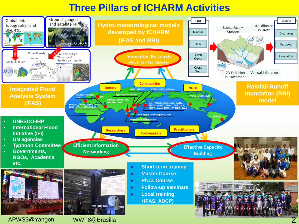
Three Pillars of ICHARM Activities
2D Diffusion
in Catchment
Subsurface +
Surface
Vertical Infiltration
1D Diffusion
in RiverRainfall
DEM
Land
Cover
Cross
Sec.
Input
Discharge
W. Level
Inundation
Output
Short-term training
Master Course
Ph.D. Course
Follow-up seminars
Local training
(IFAS, ADCP)
Hydro-meteorological models
developed by ICHARM
(IFAS and RRI)
• UNESCO-IHP
• International Flood
Initiative (IFI)
• UN agencies
• Typhoon Committee
• Governments,
NGOs, Academia
etc.
APWS3@Yangon WWF8@Brasilia
Integrated Flood
Analysis System
(IFAS)
Rainfall Runoff
Inundation (RRI)
model
Innovative Research-Advanced Technology-
Efficient Information Networking
Effective Capacity Building
UNESCO, WMO, ISDR, IAHS, IAHR, ICSU, UNESCO-IHE
MLIT, MEXT, NILIM, UNU, ADRC, FRICS, NARBO, IFNet, JWF, JICA, GRIPS, JAXA, DPRI, UY, NIED, JWA
Government of Indonesia
Government of Philippines, ADB
IWHR, IRTCES KDPA, KICT, K-Water
USGS, USBR, IWR
UCD
HidroEX
SHIRCUWM TEHRAN, IWPC
ICIMOD, BWDB, RID, DID, HTC, MRC
Donors
Researchers
CommunitiesNGOs
PolicymakersPractitioners
Typhoon Committee
2
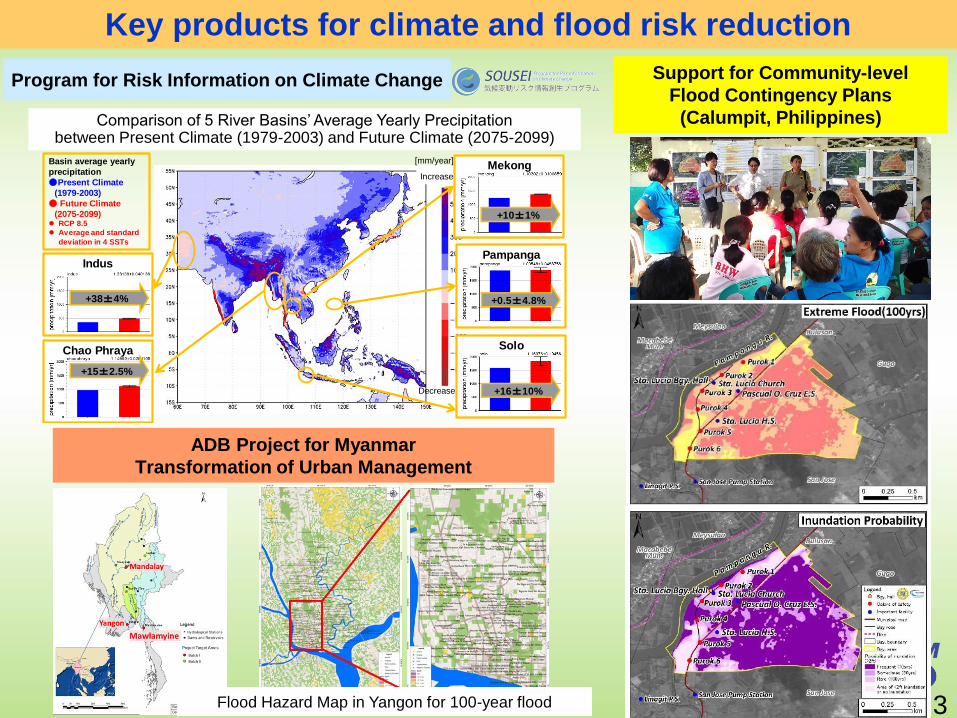
Key products for climate and flood risk reduction
IncreaseMekong
Pampanga
Solo
[mm/year]
Decrease
+0.5±4.8%
+16±10%
Chao Phraya
+15±2.5%
Indus
+38±4%
+10±1%
Basin average yearly
precipitation
●Present Climate
(1979-2003)
● Future Climate
(2075-2099) RCP 8.5
Average and standard
deviation in 4 SSTs
Support for Community-level
Flood Contingency Plans
(Calumpit, Philippines)
Flood Hazard Map in Yangon for 100-year flood
Program for Risk Information on Climate Change
Comparison of 5 River Basins’ Average Yearly Precipitation between Present Climate (1979-2003) and Future Climate (2075-2099)
ADB Project for Myanmar
Transformation of Urban Management
3
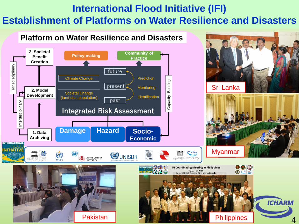
Myanmar
Pakistan Philippines
Sri Lanka
Identification
Policy-makingCommunity of
Practice
1. Data
Archiving
2. Model
Development
3. Societal
Benefit
Creation
Societal Change
(land use, population)
Climate Change
Monitoring
Prediction
Tra
nsd
iscip
lina
ry
Inte
rdis
cip
lina
ry
Ca
pa
city
Bu
ildin
g
Integrated Risk Assessment
future
present
past
Damage Hazard Socio-Economic
International Cooperation
Platform on Water Resilience and Disasters
4
International Flood Initiative (IFI)
Establishment of Platforms on Water Resilience and Disasters
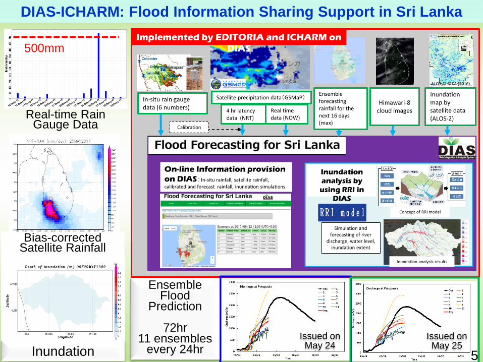
In-situ rain gauge data (6 numbers)
Satellite precipitation data(GSMaP)
On-line Information provision
on DIAS:In-situ rainfall, satellite rainfall,
calibrated and forecast rainfall, inundation simulations
Implemented by EDITORIA and ICHARM on
DIAS
ALOS © JAXA (2016)
Inundation
analysis by
using RRI in
DIAS
Simulation and forecasting of river
discharge, water level, inundation extent
Inundation analysis results
Concept of RRI model
Ensemble forecasting rainfall for the next 16 days (max)
Himawari-8 cloud images
Inundation map by satellite data (ALOS-2)
4 hr latency data (NRT)
Real time data (NOW)
Calibration
500mm
Bias-corrected Satellite Rainfall
Real-time Rain Gauge Data
Inundation
EnsembleFlood
Prediction
72hr11 ensembles
every 24hr Issued on May 24
Issued on May 25
DIAS-ICHARM: Flood Information Sharing Support in Sri Lanka
5
Thank you very much
for your kind attentions
URL: http://www.icharm.pwri.go.jp/index.html
E-mail: [email protected]
6