Embed Size (px)
Citation preview

Current status of Himawari-8/9 products development
10 October 2013 4th Asia-Oceania Meteorological Satellite Users Conference 1
Kotaro BESSHO
Meteorological Satellite Center/Japan Meteorological Agency

Contents
• What will Himawari-8/9 bring to us? • Upgrade of number of channels • Upgrade of spatial and temporal resolution
• Status of Primary Product Development of JMA • International cooperation • Cloud product • Atmospheric Motion Vector (AMV) • Aerosol product (Asian Dust) • Volcanic Ash product
• Summary
2 10 October 2013 4th Asia-Oceania Meteorological Satellite Users Conference
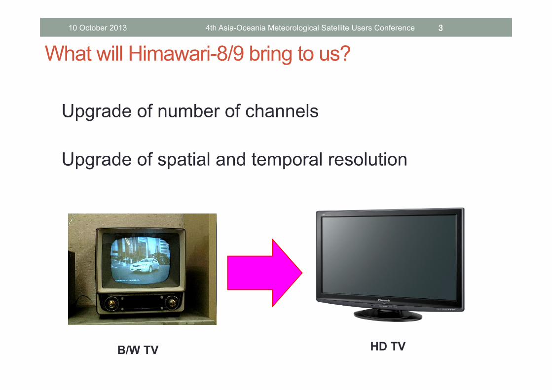
What will Himawari-8/9 bring to us?
Upgrade of number of channels Upgrade of spatial and temporal resolution
3 10 October 2013 4th Asia-Oceania Meteorological Satellite Users Conference
B/W TV HD TV

RGB band Composited
Water vapor
Atmospheric Windows
SO2
O3
CO2
0.51 µm(Band 2) instead of ABI’s 1.38 µm
VIS
IR1
IR2
IR3
IR4
MTSAT-‐1R/2
True Color Image
Products • Volcanic Ash • Global Instability Index • NowcasJng • Typhoon Analysis • Atmospheric MoJon Vector
• Clear Sky Radiance • Sea Surface Temperature
• Yellow Sands • Snow and Ice Coverage
Band Wavelength [µm]
Spatial Resolution
1 0.46 1Km
2 0.51 1Km
3 0.64 0.5Km
4 0.86 1Km
5 1.6 2Km
6 2.3 2Km
7 3.9 2Km
8 6.2 2Km
9 7.0 2Km
10 7.3 2Km
11 8.6 2Km
12 9.6 2Km
13 10.4 2Km
14 11.2 2Km
15 12.3 2Km
16 13.3 2Km
SpecificaJon of Himawari-‐8/9 Imager (AHI) Similar to ABI for GOES-R
10 October 2013 4th Asia-Oceania Meteorological Satellite Users Conference 4

IR image difference of spatial resolution 2km for H-‐8/9 4km for MTSAT
10 October 2013 4th Asia-Oceania Meteorological Satellite Users Conference 5

AHI will scan all sectors within 10 minutes
Region 1 NE-‐JAPAN
Region 2 SW-‐JAPAN
Region 3
Typhoon
Region 4 Land mark Region 5
Land mark
Full disk Interval : 10 minutes (6 @mes per hour) 23 swath
Region 1 JAPAN (North-‐East) Interval : 2.5 minutes (4 @mes in 10minutes) Dimension : EW x NS: 2000 x 1000 km 2 swath
Region 2 JAPAN (South-‐West) Interval : 2.5 minutes (4 @mes in 10minutes) Dimension : EW x NS: 2000 x 1000 km 2 swath
Region 3 Typhoon Interval : 2.5 minutes (4 @mes in 10minutes) Dimension : EW x NS: 1000 x 1000 km 2 swath
Region 4 Land mark Interval : 0.5 minutes (20 @mes in 10minutes) Dimension : EW x NS: 1000 x 500 km 1 swath
Region 5 Land mark Interval : 0.5 minutes (20 @mes in 10minutes) Dimension : EW x NS: 1000 x 500 km 1 swath
10 October 2013 4th Asia-Oceania Meteorological Satellite Users Conference 6

MTSAT-1R Rapid Scan every 10 min Australia on 1 Oct. 2013
10 October 2013 4th Asia-Oceania Meteorological Satellite Users Conference 7

MTSAT-1R Rapid Scan every 10 min Typhoon on 1 Oct. 2013
10 October 2013 4th Asia-Oceania Meteorological Satellite Users Conference 8

MTSAT-1R Rapid Scan every 5 min Gust front on 1 Oct. 2013
10 October 2013 4th Asia-Oceania Meteorological Satellite Users Conference 9

10
Development of products of Himawari-‐8/9 AHI
Examples of expected new/enhanced products - Cloud Products - Atmospheric Motion Vectors (AMVs)- Aerosol (Dust) / Volcanic Ash
Higher resoluJon Spa@al: 1km -‐> 0.5km for a VIS channel 4km -‐> 2 km for IR channels Temporal: 1 hr -‐> 10 min for a full disk scan 2.5min for limited areas
Increased observaJon channels VIS: 1 -‐> 3 bands IR : 4 -‐> 13 bands
Severe weather monitoring/ nowcasting
Numerical prediction
Volcano eruption Ash area detection
Climate change monitoring
Yellow sand/ dust storm Solar energy monitoring
10 October 2013 4th Asia-Oceania Meteorological Satellite Users Conference 10
Next Weather Satellite Revolution
toward
the New Era
of
Mesoscale Satellite Meteorology
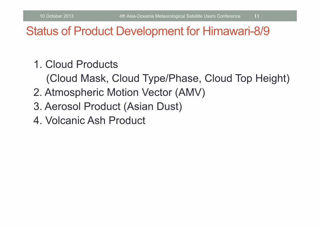
Status of Product Development for Himawari-8/9
1. Cloud Products
(Cloud Mask, Cloud Type/Phase, Cloud Top Height) 2. Atmospheric Motion Vector (AMV) 3. Aerosol Product (Asian Dust) 4. Volcanic Ash Product
11 10 October 2013 4th Asia-Oceania Meteorological Satellite Users Conference

International Cooperation for developments of Cloud Product, AMV and volcanic ash product
• Nov. 2012 Look Up Table (LUT) and software for Volcanic Ash retrieval was provided from EUMETSAT.
• Jan. 2013 JMA invited scientists from EUMETSAT and UK Met Office. Dr. Hans-Joachim Lutz (EUMETSAT) Dr. Régis Borde (EUMETSAT) Dr. Peter Francis (UK Met Office)
• Feb. 2013 JMA invited scientist from NOAA/NESDIS Dr. Andrew Heidinger (NOAA/NESDIS) Dr. Mike Pavolonis (NOAA/NESDIS)
• April-May 2013 JMA/MSC scientist visited EUMETSAT for the development of OCA and AMV.
Mr. Masahiro Hayashi (JMA/MSC)
12
We greatly appreciate kind cooperation of EUMETSAT and NOAA/NESDIS.
10 October 2013 4th Asia-Oceania Meteorological Satellite Users Conference

Status of Product Development for Himawari-8/9 (1/4) 1.Cloud Products (Mask, Type/Phase , Cloud Top Temperature/Pressure)
Satellite : Himawari-8/9 Improvement : Common product for generating other products Algorithm : Based on EUMETSAT/NWC-SAF/MSG algorithm. Partly introduced NOAA/NESDIS/GOES-R algorithm (A.Heidinger et.al) for Mask and Type determinations. Status : Created prototype software for MSG area
13 10 October 2013 4th Asia-Oceania Meteorological Satellite Users Conference

RGB Image R: 0.64um G: 0.86um B: 11.2um
Cloud Mask
15:12UTC 7th Apr. 2012, MSG
Cloud Products (Prototype)
10 October 2013 4th Asia-Oceania Meteorological Satellite Users Conference 14

fractional
very high opaque
high opaque
medium opaque
low opaque
very low opaque
semi-trans p. thick
sem. meanly thick semi-trans p. thin
Cloud Type Cloud Top Height (hPa)
1512UTC 7th Apr. 2012, MSG
Cloud Products (Prototype)
10 October 2013 4th Asia-Oceania Meteorological Satellite Users Conference 15

Status of Product Development for Himawari-8/9 (2/4) 2. Atmospheric Motion Vector (AMV)
Satellite : MTSAT-2,Himawari-8/9 Improvement : High spatial resolution AMV Algorithm : Pattern recognition technique using Maximum likelihood estimation method (JMA) Status : Created prototype software
16 10 October 2013 4th Asia-Oceania Meteorological Satellite Users Conference
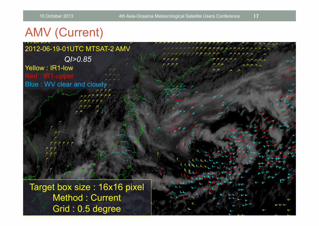
17
2012-06-19-01UTC MTSAT-2 AMV
QI>0.85 Yellow : IR1-low Red : IR1-upper Blue : WV clear and cloudy
Target box size : 16x16 pixel Method : Current Grid : 0.5 degree
AMV (Current) 10 October 2013 4th Asia-Oceania Meteorological Satellite Users Conference

2012-06-19-01UTC MTSAT-2 AMV
QI>0.85 Yellow : IR1-low Red : IR1-upper Blue : WV clear and cloudy
Target box size : 5x5 pixel Method : MLE
Grid : 0.2 degree
18
AMV (Prototype) 10 October 2013 4th Asia-Oceania Meteorological Satellite Users Conference
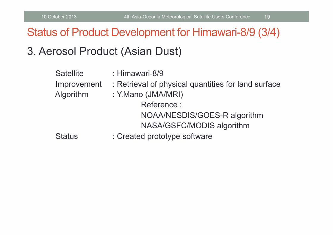
Status of Product Development for Himawari-8/9 (3/4) 3. Aerosol Product (Asian Dust)
Satellite : Himawari-8/9 Improvement : Retrieval of physical quantities for land surface Algorithm : Y.Mano (JMA/MRI) Reference : NOAA/NESDIS/GOES-R algorithm NASA/GSFC/MODIS algorithm Status : Created prototype software
19 10 October 2013 4th Asia-Oceania Meteorological Satellite Users Conference

20
Aerosol Product (Prototype)
Trial processing with MODIS/Terra (0430 UTC), without cloud mask
Current Algorithm with MTSAT-2 (0500 UTC)
Prototype (MODIS/Terra) Current (MTSAT-2)
AOD (Atomospheric Optical Depth)
10 October 2013 4th Asia-Oceania Meteorological Satellite Users Conference

• Reviewed ATBD for NOAA/NESDIS aerosol product (2012.4-6) • Designed LUT for aerosol retrieval and generated the 1st version of LUT
(2012.8-11) • Experimental retrieval from MODIS L1B data (2012.12) • Software and/or LUT will be adjusted using Himawari-8 data after the data
becomes available. • JMA will also introduce NOAA/NESDIS volcanic ash algorithm.
21
Aerosol Product / Current Status and Plan
10 October 2013 4th Asia-Oceania Meteorological Satellite Users Conference

Status of Product Development for Himawari-8/9 (4/4) 4.Volcanic Ash Product
Satellite : MTSAT-2, Himawari-8/9 Improvement : New product (Optical Depth, Particle Radius, Mass Loading, Ash cloud top height) Algorithm : Ash cloud detection (M.Pavolonis/NOAA/NESDIS, S.Mackie/Univ.of Bristol) Retrieval processing (F.Prata/NILU) Status : Preparing for operational generating.
Discussing about validation with Tokyo VAAC.
22 10 October 2013 4th Asia-Oceania Meteorological Satellite Users Conference

23
Volcanic Ash Product
Sarychev 2009.6.14 0300UTC, MTSAT-1R
Shinmoe-dake 2011.1.27 0000UTC, MTSAT-2
Mt. Merapi 2010.11.11 2000UTC, MTSAT-1R
Bulusan 2011.2.21 0400UTC, MTSAT-2
Mass loading Mass loading
Mass loading Mass loading
10 October 2013 4th Asia-Oceania Meteorological Satellite Users Conference

Step 1: Introducing EUMETSAT Volcanic Ash Retrieval software for MSG in JMA/MSC by March 2013
- JMA/MSC has installed software on the computer system and applied it to MTSAT-2 in collaboration with EUMETSAT
- The new volcanic ash product started to be provided for VAAC/Tokyo in pre-operation mode (March, 2013)
Step 2: Introducing NOAA/NESDIS Volcanic Ash Retrieval software in
JMA/MSC in collaboration with NOAA/NESDIS - JMA/MSC and NOAA/NESDIS had a technical meeting on the Volcanic Ash Retrieval
algorithm and software - Procedure to install NOAA/NESDIS software is ongoing
Step 3: JMA/MSC will operate above two products in parallel and
provide to VAAC/Tokyo after Himawari-8 will be in operation Step 4: Further verification and improvements will be done in
cooperation with EUMETSAT and NOAA/NESDIS
24
Volcanic Ash Product / Current Status and Plan
10 October 2013 4th Asia-Oceania Meteorological Satellite Users Conference
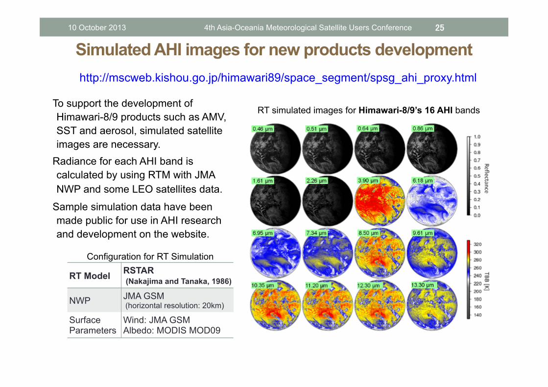
Simulated AHI images for new products development 25
To support the development of Himawari-8/9 products such as AMV, SST and aerosol, simulated satellite images are necessary.
a Radiance for each AHI band is calculated by using RTM with JMA NWP and some LEO satellites data.
a Sample simulation data have been made public for use in AHI research and development on the website.
RT simulated images for Himawari-8/9’s 16 AHI bands
RT Model RSTAR (Nakajima and Tanaka, 1986)
NWP JMA GSM (horizontal resolution: 20km)
Surface Parameters
Wind: JMA GSM Albedo: MODIS MOD09
Configuration for RT Simulation
http://mscweb.kishou.go.jp/himawari89/space_segment/spsg_ahi_proxy.html
10 October 2013 4th Asia-Oceania Meteorological Satellite Users Conference

http://mscweb.kishou.go.jp/index.htm
26 10 October 2013 4th Asia-Oceania Meteorological Satellite Users Conference

• Himawari-8/9 will bring us Mesoscale Satellite Meteorology.
• JMA Primary Product development is on going.
• We will just do it!!
27
Summary
10 October 2013 4th Asia-Oceania Meteorological Satellite Users Conference

28
Thank you for your attention.
10 October 2013 4th Asia-Oceania Meteorological Satellite Users Conference

29
Backup Slides
10 October 2013 4th Asia-Oceania Meteorological Satellite Users Conference

Himawari-8/9
Antenna
Solar Panel
★ Major characteristics of Himawari-8/9 ★ ● Contractor: MELCO (Mitsubishi Electric Corporation) ● Attitude control: Three-axis stabilization ● Launch Schedule: 2014 (Himawari-8) 2016 (Himawari-9) ● Communication: 402 MHz (UHF-band) 13, 14/12 GHz (Ku-Band) 18 GHz (Ka-band)
Advanced Himawari Imager (AHI) Channels Visible (4 channels)
Infrared (12 channels) Resolutions 0.5 Km, 1 Km and 2 Km Brightness levels >= 11 bits
Advanced Himawari Imager (AHI)
Status of Manufacture
30 10 October 2013 4th Asia-Oceania Meteorological Satellite Users Conference

AMV / Algorithm improvement (JMA Original) 31
• Upgrade to tracking algorithm based in maximum likelihood estimation method (MLE)
-> for high spatial resolution AMV • Installation of cloud height assignment algorithm
based on optimal estimation (NEW) -> for decreasing wind speed BIAS and RMSVD caused from height estimation error
10 October 2013 4th Asia-Oceania Meteorological Satellite Users Conference

Maximum Likelihood Approach to Cloud Motion Estimation
32
1. To equate cross-correlation value with likelihood • cross-correlation is large -> matching probability is large
2. To compute posterior probability from prior probability and auxiliary information • prior probability : correlation surface from small target box • auxiliary information : correlation surface from large target box • Posterior probability is computable by averaging two matching surface
3. To search position that shows maximum cross-correlation (maximum likelihood)
10 October 2013 4th Asia-Oceania Meteorological Satellite Users Conference

AMV derivation experiment using new tracking and HA technique
Satellite : MTSAT-2 Period : July 2012 (summer) and January 2013 (winter) • Tracking method RTN : Cross-Correlation, 16x16 pixels TEST : Cross-Correlation, MLE using 5x5 and 15x15 pixels • Height assignment method RTN : operational method TEST : Cloud alignment model : 3 layers PDF : multivariate student t distribution (t=1) Optimization method : Nelder-Mead
33 10 October 2013 4th Asia-Oceania Meteorological Satellite Users Conference
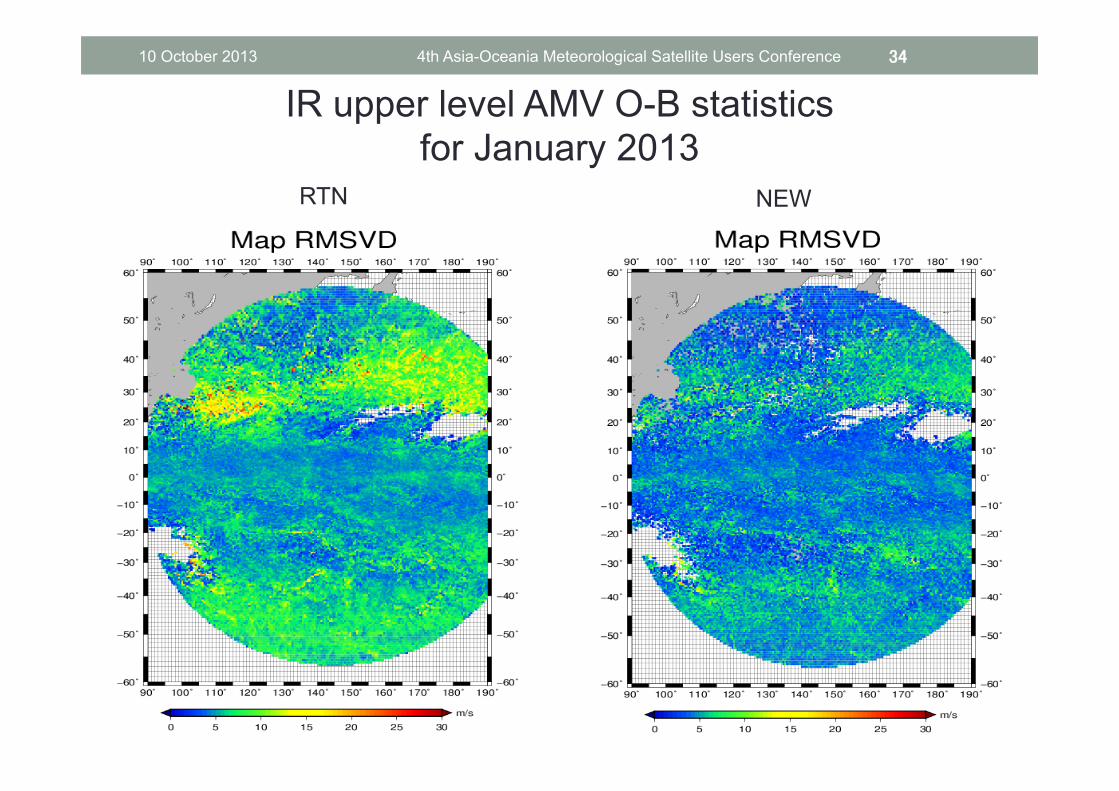
RTN NEW
IR upper level AMV O-B statistics for January 2013
34 10 October 2013 4th Asia-Oceania Meteorological Satellite Users Conference

RTN NEW
IR upper level AMV O-B statistics for January 2013
35 10 October 2013 4th Asia-Oceania Meteorological Satellite Users Conference

RTN TEST
IR upper level AMV O-B statistics for July 2012
36 10 October 2013 4th Asia-Oceania Meteorological Satellite Users Conference

RTN TEST
IR upper level AMV O-B statistics for July 2012
37 10 October 2013 4th Asia-Oceania Meteorological Satellite Users Conference