Embed Size (px)
Citation preview
THE GEOLOGICAL SOCIETY OF AMERICA
Special Paper 400
I
in New Guinea: The Geotectonics of Subducting Slab Breakoff
by Mark Cloos
Benyamin Sapiie
Andrew Quarles van Ufford
Richard J. Wei land
Paul Q. Warren
Timothy P. McMahon
Copyright © 2005, The Geological Society of America, Inc. (GSA). All rights reserved. GSA grants permission to individual scientists to make unlimited photocopies of one or more items from this volume for noncommercial purposes advancing science or education, including classroom use. For permission to make photocopies of any item in this volume for other noncommercial, nonprofit purposes, contact the Geological Society of America. Written permission is required from GSA for all other forms of capture or reproduction of any item in the volume including, but not limited to, all types of electronic or digital scanning or other digital or manual transformation of articles or any portion thereof, such as abstracts, into computer-readable and/or transmittable form for personal or corporate use, either noncommercial or commercial, for-profit or otherwise. Send permission requests to GSA Copyright Permissions, 3300 Penrose Place, P.O. Box 9140, Boulder, Colorado 80301-9140, USA.
Copyright is not claimed on any material prepared wholly by government employees within the scope of their employment.
Published by The Geological Society of America, Inc. 3300 Penrose Place, P.O. Box 9140, Boulder, Colorado 80301-9140, USA www.geosociety.org
Printed in U.S.A.
GSA Books Science Editor: Abhijit Basu
Lib1·a•-y of Congress Cataloging-in-Publication Data
Collisional delamination in New Guinea : the geotectonics of subducting slab breakoff I by Mark Cloos ... [et al.]
p. em. -(Special paper ; 400) Includes bibliographical references. ISBN 0-8137-2400-7 (pbk.)
1. Subduction zones--New Guinea. 2. Slabs (Structural geology)--New Guinea. 3. Geology, Structural--New Guinea. 4 . Orogeny--New Guinea. I. Cloos, Mark. II Special papers (Geological Society of America) ; 400
QE511 .46 .C65 2005 551.1 '36--dc22
2005055351
Cove•·: View looking west from near Puncak Jaya along crest of Central range, west New Guinea. Folded, Late Miocene New Guinea Limestone Group strata are in the foreground . The Grasberg giant porphyry copper-gold deposit is in the background . Photo by Andrew Q uarles van Ufford .
10 9 8 7 6 5 4 3 2 1
11
1
Cloos, M., Sapiie, B., Quarles van Ufford, A., Weiland, R.J., Warren, P.Q., and McMahon, T.P., 2005, Collisional delamination in New Guinea: The geotectonics of subducting slab breakoff: Geological Society of America Special Paper 400, 51 p., doi: 10.1130/2005.2400. For permission to copy, contact [email protected]. ©2005 Geological Society of America.
Geological Society of AmericaSpecial Paper 400
2005
Collisional delamination in New Guinea:The geotectonics of subducting slab breakoff
Mark CloosBenyamin Sapiie
Andrew Quarles van UffordRichard J. Weiland
Paul Q. WarrenTimothy P. McMahon
Department of Geological Sciences, University of Texas, Austin, Texas 78712, USA
ABSTRACT
The spine of the island of New Guinea, the Central Range, is a 1300 km long by 100 to 150 km wide mountain belt with numerous peaks over 3 km elevation. This mountain belt began to form when the Australian passive margin entered a north-dipping subduction zone in the Middle Miocene. Regional relationships and fi eldwork near the Ertsberg (Gunung Bijih) mining district in the western Central Range are the basis for making a detailed reconstruction of the events leading up to, and during, collisional orogenesis.
Most of New Guinea can be divided into fi ve lithotectonic belts. From north to south, these are an accreted arc terrane, an upturned forearc basement, an underly-ing metamorphic belt, a highlands fold-and-thrust belt, and a foreland basin. In west-ern New Guinea, the accreted arc/forearc is the northwestern end of the Melanesian Arc Terrane that was the product of two phases of subduction volcanism since the Eocene. This terrane is largely buried under debris shed northwards from the Cen-tral Range. The crystalline leading edge of the accreted arc/forearc terrane, the Irian Ophiolite Belt of Jurassic age, is upturned forearc basement forming the north fl ank of the Central Range. The ophiolite is underlain by the Ruffaer Metamorphic Belt, which comprises continental rise and slope sediments and probably some trench axis deposits that underwent subduction deformation and metamorphism since the Early Miocene. The metamorphic belt grades into the highlands fold-and-thrust belt, which contains carbonate shelf strata at least as young as 15 Ma. Kilometer-scale, angular to rounded folds are the dominant structures. Regional sedimentologic relationships indicate the highlands area has constituted a 500+ km long landmass since ca. 12 Ma. The southern fl ank of the western Central Range is a giant 300 km long by 30 km wide basement block that has been thrust southwards since 8 Ma, forming the Mapenduma anticline. Minor, but widely distributed, magmatism occurred along the spine of the western highlands from ca. 7.5 to 2.5 Ma. There is abundant evidence for minor left-lateral strike-slip faulting subparallel to the upturned bedding that was concurrent with igneous activity at 4–3 Ma.
These relationships, combined with consideration of the mechanical properties of the crust and lithospheric mantle, are the basis for the construction of a series of lithospheric-scale cross sections illustrating the process of collisional delamination. Subduction tectonism and metamorphism began at ca. 30 Ma. Underthrusting of
2 M. Cloos et al.
Australian continental margin sediments was well under way by ca. 15 Ma, when small isolated islands emerged. Bulldozing of the sediment cover formed an elongate landmass by ca. 12 Ma, and siliciclastic sediment was shed southwards, overwhelm-ing carbonate shelf sedimentation. Collisional orogenesis due to the jamming of the subduction zone and initiation of thick-skinned crust-involved deformation began at ca. 8 Ma. Magma generation due to asthenospheric upwelling and decompression of stretched lithospheric mantle occurred from ca. 7.5 to 3 Ma. Contractional deforma-tion in the western highlands ended at ca. 4 Ma, when this region became a site of minor northwest-striking, left-lateral strike-slip faulting. Since ca. 2 Ma, offset has been localized along the Yapen fault zone near the north coast of the island.
Collisional delamination involved the decapitation of the crust, continued sinking of the subducted lithosphere, and the upwelling of asthenosphere into the rupture as fast as it separated. This ensuing adiabatic decompression melting manifested itself as a short-lived magmatic event and up to 2.5 km of vertical uplift, both centered on the spine of the collision-generated orogenic belt. Collisional orogenesis is still under way beneath the eastern Central Range, with delamination-generated magmatism in its waning stages. Starting at ca. 8 Ma, the tear rupturing the subducting Australian lithosphere propagated from west to east at a rate of ~150 km/m.y.
Keywords: collision, delamination, New Guinea, subduction, orogeny.

3
INTRODUCTION
The spine of the island of New Guinea, the Central Range, is a major orogenic belt that formed as the result of the con-vergence between the Australian and Pacifi c plates (Fig. 1). In fact, Wegener (1924, p. 67–70) described the island as a site of Cenozoic mountain building due to continental drift. Dewey and Bird (1970) considered New Guinea as the type locality of recent island arc–continent collision. Tectonism has occurred on a grand scale with the New Guinea orogen, comparable in size to the western U.S. Cordillera (Silver and Smith, 1983).
Geological Society of AmericaSpecial Paper 400
2005
Chapter 1
Geology of the Central Range of Western New Guinea
The Central Range of New Guinea began to form when the Australian passive margin entered a north-dipping sub-duction zone in the Middle Miocene. Convergence resulted in the emplacement of a forearc basement complex on top of deformed passive margin strata and Australian continental crust. Distinct stages in the orogeny are dated from regional sedimentologic, metamorphic, and magmatic relationships. Australian-Pacifi c plate motions place tight constraints on the kinematic evolution of the island during the Cenozoic. These observations, combined with consideration of the mechanical properties of oceanic and continental lithosphere, are the basis
140o E 144o E 148o E
132o E 136o E 140o E 144o E 148o E
4o S
8o S
0o
BandaSea
CoralSea
ArafuraSea
Indonesia
Bismarck Sea
SolomonSea
Papua NewGuinea A
FTB
152o E
152o E
P h a n e r o z o i cb a s e m e n t
P r e c a m b r i a nb a s e m e n t
4o S
Aust.
Pk. Jaya,4884 m
Li n
e
Ta
sm
an
MDZ
M a n u s T r e n c h
K i l i n a i l u aT
r en
c h
Mu
ss
au
Tr
ou
gh
N e w B r i t a i n T r e n c h
T r o b r i a n d T r o u g h
M a n o k w a r i T r o u g h
W o o d -l a r k
R i s e
Ay
u T
ro
ug
h
A u s t r a l i a n
B i s m a r c k P l a t eT A F Z
Y F Z
B T F Z
S F Z
Ar
uT
ro
ug
h
LF
T
B
1000 m
0o
1000 m
RMFZ
I r i a n F T B
P a p u a n T F B
1000 m
+
Pacific Ocean
< ~ 4 MaP a c i f i c / C a r o l i n e P l a t e
P a c i f i c
30+ to ~ 4 Ma
P l a t e
Ade lbe r t
F i nn i s t e r r e
KA
9.5 cm / y
ear at ~
243o
11 cm / year at ~252o
S e r a mT r o
ug
h
MUA
DM
MABD
KepulauanTanimbar
P l a t e
Ophiolites and ultramafic rocks
Approximate limit of underthrust Australian continental crust
Exposed continental basement
Inactive deformation front
Slow convergence (< 2 cm/yr)
Rapid convergence (> 2 cm/yr)
Active spreading oceanic ridge
Active strike-slip fault zone
Inactive strike-slip fault zone
Relative plate motion vector with respect to the Australian plate
EXPLANATION
0 100 200 mi
0 100 200 300 km
u
uErtsbergMiningDistrict
10 cm / year at ~270o?
~ 5 - 3 Ma
SalawatiBasin
Cendr
awas
ih
Bay I O B
P O B
Bintinui Basin
IDI
WO
C e n t r a l R a n g e F o r e l a nd
New Guinea Trench
Wewak SegmentMelanesianArc
Terrane
Figure 1. Tectonic map of New Guinea, adapted from Hamilton (1979), Cooper and Taylor (1987), Dow et al. (1988), and Sapiie et al. (1999).AFTB—Aure fold and thrust belt, FTB—fold-and-thrust belt, IOB—Irian Ophiolite Belt, TFB—thrust-and-fold belt, POB—Papuan Ophiolite Belt, BTFZ—Bewani-Torricelli fault zone, MDZ—Mamberamo deformation zone, YFZ—Yapen fault zone, SFZ—Sorong fault zone, WO—Wey-land overthrust. Continental basement exposures are concentrated along the southern fl ank of the Central Range: BD—Baupo Dome, MA—Map-enduma anticline, DM—Digul monocline, IDI—Idenberg Inlier, MUA—Mueller anticline, KA—Kubor anticline, LFTB—Legguru fold-and-thrust belt, RMFZ—Ramu-Markham fault zone, TAFZ—Tarera-Aiduna fault zone. The Tasman line separates continental crust that is Paleozoic and younger to the east from Precambrian to the west.
4 M. Cloos et al.
for drawing a series of scaled diagrams illustrating the process of collisional delamination beneath New Guinea.
This report is divided into three chapters. Chapter 1 sum-marizes the geology of the western Central Range in the area where we made our regional transect. Chapter 2 concerns the mechanics of collisional delamination—the process we envi-sion to account for the pattern—and the timing of deforma-tion, metamorphism, sedimentation, and magmatism. These concepts should be applicable to all similar collisional settings. Chapter 3 presents a series of scaled, lithospheric-scale cross sections illustrating the late Cenozoic tectonic evolution of western New Guinea.
GEOLOGY OF WESTERN NEW GUINEA
Geologic Framework
The outline of the island of New Guinea has been described as similar to a bird fl ying westward with an open mouth (Fig. 1). As a result, the island is commonly geographically divided into the Bird’s Head, Neck, Body, and Tail regions. The northern half of the island is underlain by the Melanesian Arc Terrane that was built on Mesozoic ocean crust. The southern half is underlain by Australian continental crust. The collisional welding of the oceanic terrane onto the Australian continental margin generated the Central Range, the 1300 km by 100 to 150 km mountain-ous spine with numerous peaks over 3 km elevation. The range stretches from the Bird’s Neck (~135° E) to the Bird’s Tail (Papuan Peninsula, ~146° E) (Dewey and Bird, 1970; Hamilton, 1979).
The northern accreted arc/forearc terrane is largely buried beneath sediments shed northwards from the Central Range (Fig. 1). The crystalline leading edge (forearc basement) of this sub-duction system, the Irian Ophiolite Belt, is upturned and exposed along the lower slopes of the north fl ank of the Central Range.
The southern half of the island is composed of rocks depos-ited on top of Australian continental basement. The western Central Range can be subdivided, from north to south, into three parts: the Ruffaer Metamorphic Belt, the highlands fold-and-thrust belt, and the foreland basin. The metamorphic and fold-and-thrust belts are composed of deformed Australian passive margin strata. The southern fl ank of the range contains several windows into uplifted continental basement (Fig. 1). The fore-land basin contains a thick wedge of late Cenozoic siliciclastic debris that was shed southwards. These strata blanket carbon-ate shelf deposits on top of transitional continental crust that was thinned during Mesozoic rifting.
Cenozoic Plate-Tectonic Setting
The Central Range of New Guinea is almost entirely the product of late Cenozoic convergence between the Australian and Pacifi c plates. Since ca. 3 Ma, the relative tectonic motion between these plates for a location in the middle of the Cen-tral Range is at a rate of 114 km/m.y. along an azimuth of 252°
(DeMets et al., 1990, 1994). The present-day pole of rotation for Pacifi c-Australian motions is located near New Zealand. Con-sequently, along the 2000 km length of the Australian-Pacifi c plate boundary in the New Guinea region, the calculated vec-tor for current relative motion varies by <5° in direction and <5 km/m.y. in speed.
Global plate reconstructions indicate that the relative motion between the Australian and Pacifi c plates changed in the latest Cenozoic. This recent change in Pacifi c plate motion has been estimated as occurring at 5 Ma based upon the bend in the Hawaiian seamount chain at Oahu (Cox and Engebretson, 1985). Analysis of deviations in magnetic anomalies along the East Pacifi c Rise indicates the change dates between 5.0 and 3.2 Ma (Pollitz, 1986), most specifi cally at 3.9 Ma (Harbert and Cox, 1989, 1990). As will be discussed, we believe this change is a direct result of the collision that formed the Central Range of New Guinea. The global plate reconstructions of Scotese et al. (1988) indicate that the relative Australian-Pacifi c plate motion in the New Guinea region changed in azimuth by ~9° clockwise and increased in speed by ~15 km/m.y. (see arrows on Fig. 1). In other words, the current local relative motions are more oblique to the strike of the Central Range and slightly faster than they were during the mountain-forming collision.
The ocean crust in most of the west-central Pacifi c Basin is Jurassic; however, crust north of New Guinea is early Cenozoic. The origin of this area of seafl oor is a tectonic conundrum, and it occurred before the time period of primary interest in this report. More signifi cantly, most of this area of anomalously young sea-fl oor was named the Caroline plate, and it has a debatable move-ment history (Weissel and Anderson, 1978). Hegarty et al. (1983) identifi ed the Mussau Trough as the eastern boundary between the Pacifi c and Caroline plates. They concluded that there has been at most a few tens of kilometers of convergence at this location, but that it is currently inactive or nearly so (Hegarty and Weissel, 1988) (see Fig. 1). Thus, the Caroline plate (or bet-ter, microplate) must have moved in a direction and at a rate that is nearly the same as that of the Pacifi c plate. Cloos (1992b) con-cluded that the Caroline microplate is simply a broken corner of the Pacifi c plate that was a distinct kinematic entity for only a short period, between ca. 5 and 3 Ma. As will be discussed, this is considered to be a globally minor, but locally signifi cant, adjustment in the collisional tectonic movements that generated the Central Range. Movement of the Caroline microplate caused a short-lived episode of strike-slip faulting in the core of the western highlands, which aided the ascent of magmas (Sapiie and Cloos, 2004). However, compared to the many tens of kilo-meters of contractional deformation prior to and during the col-lisional orogenesis, a few kilometers of strike-slip movements are very minor.
Active Tectonism
Most of the seismicity occurring beneath the island of New Guinea is clustered near the Huon Peninsula, the Mamberamo

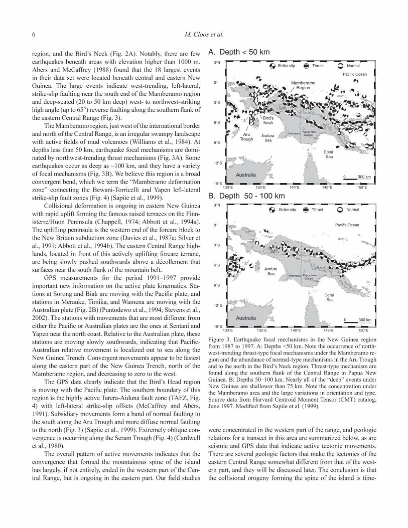
Figure 2. A: The distribution of earthquake epicenters in the New Guinea region for all depths with magnitude M > 4 from 1977 to 1997. Note the very limited seismicity beneath areas with elevations higher than 1000 m. Source data from the Institute for Research in Seismology (IRIS) catalog, June 1997. Modifi ed from Sapiie et al. (1999). B: Movement detected during global positioning system (GPS) survey from 1991 to 1997 by Stevens et al. (2002). The published survey data are only for a six-year period, but the basic kinematics are apparent. The Bird’s Head block with stations at Biak, Manokwari, and Sorong are moving in directions that parallel those of the Pacifi c plate. The stations at Timika, Wamena, Merauke, Aru, and Saumlakki are moving with the Australian plate. Fak Fak is moving nearly parallel to the Biak station but slower. The difference between Biak and Yapen indicates ~5 cm/yr of left-lateral motion along the Yapen fault zone. The difference between the Kaimana and Timika/Aru stations indicates ~6 cm/yr of left-lateral motion along the Tarera-Aiduna fault zone. The station at Sentani has a speed and direction of movement that is intermediate to the two major plates, indicating that some (most?) of the relative motion is accommodated along the eastern segment of the New Guinea Trench (Wewak segment), and the Mamberamo deformation zone. NGT—New Guinea Trench, BTFZ—Bewani-Torricelli fault zone, MDZ—Mamberamo deformation zone, YFZ—Yapen fault zone, ST—Seram Trough, TAFZ—Tarera-Aiduna fault zone, AT—Aru Trough.
6 M. Cloos et al.
region, and the Bird’s Neck (Fig. 2A). Notably, there are few earthquakes beneath areas with elevation higher than 1000 m. Abers and McCaffrey (1988) found that the 18 largest events in their data set were located beneath central and eastern New Guinea. The large events indicate west-trending, left-lateral, strike-slip faulting near the south end of the Mamberamo region and deep-seated (20 to 50 km deep) west- to northwest-striking high angle (up to 65°) reverse faulting along the southern fl ank of the eastern Central Range (Fig. 3).
The Mamberamo region, just west of the international border and north of the Central Range, is an irregular swampy landscape with active fi elds of mud volcanoes (Williams et al., 1984). At depths less than 50 km, earthquake focal mechanisms are domi-nated by northwest-trending thrust mechanisms (Fig. 3A). Some earthquakes occur as deep as ~100 km, and they have a variety of focal mechanisms (Fig. 3B). We believe this region is a broad convergent bend, which we term the “Mamberamo deformation zone” connecting the Bewani-Torricelli and Yapen left-lateral strike-slip fault zones (Fig. 4) (Sapiie et al., 1999).
Collisional deformation is ongoing in eastern New Guinea with rapid uplift forming the famous raised terraces on the Finn-isterre/Huon Peninsula (Chappell, 1974; Abbott et al., 1994a). The uplifting peninsula is the western end of the forearc block to the New Britain subduction zone (Davies et al., 1987a; Silver et al., 1991; Abbott et al., 1994b). The eastern Central Range high-lands, located in front of this actively uplifting forearc terrane, are being slowly pushed southwards above a décollement that surfaces near the south fl ank of the mountain belt.
GPS measurements for the period 1991–1997 provide important new information on the active plate kinematics. Sta-tions at Sorong and Biak are moving with the Pacifi c plate, and stations in Merauke, Timika, and Wamena are moving with the Australian plate (Fig. 2B) (Puntodewo et al., 1994; Stevens et al., 2002). The stations with movements that are most different from either the Pacifi c or Australian plates are the ones at Sentani and Yapen near the north coast. Relative to the Australian plate, these stations are moving slowly southwards, indicating that Pacifi c-Australian relative movement is localized out to sea along the New Guinea Trench. Convergent movements appear to be fastest along the eastern part of the New Guinea Trench, north of the Mamberamo region, and decreasing to zero to the west.
The GPS data clearly indicate that the Bird’s Head region is moving with the Pacifi c plate. The southern boundary of this region is the highly active Tarera-Aiduna fault zone (TAFZ, Fig. 4) with left-lateral strike-slip offsets (McCaffrey and Abers, 1991). Subsidiary movements form a band of normal faulting to the south along the Aru Trough and more diffuse normal faulting to the north (Fig. 3) (Sapiie et al., 1999). Extremely oblique con-vergence is occurring along the Seram Trough (Fig. 4) (Cardwell et al., 1980).
The overall pattern of active movements indicates that the convergence that formed the mountainous spine of the island has largely, if not entirely, ended in the western part of the Cen-tral Range, but is ongoing in the eastern part. Our fi eld studies
were concentrated in the western part of the range, and geologic relations for a transect in this area are summarized below, as are seismic and GPS data that indicate active tectonic movements. There are several geologic factors that make the tectonics of the eastern Central Range somewhat different from that of the west-ern part, and they will be discussed later. The conclusion is that the collisional orogeny forming the spine of the island is time-
1000 m
Australia
Arafura Sea
Coral Sea
Pacific Ocean
Indonesia Papua New Guinea
Pk. Jaya4884 m
0 300 km
77191
78102
78283791648026482073
2326
86288
8702187168
251891492125
Strike-slip Thrust Normal
B. Depth 50 - 100 km
1000 m
78115
78203
79114
79175
80177
8122982078
82088
841538415841685154
852388604386043 8609
8615
870758707587075
87161
8723
87323
88163
882548826890342
91186
Australia
Arafura Sea
Coral Sea
Pacific Ocean
IndonesiaPapua New Guinea
Pk. Jaya4884 m
0 300 km
Strike-slip Thrust Normal
A. Depth < 50 km
15°S
12°S
9°S
6°S
3°S
0°
3°N
130°E 135°E 140°E 145°E 150°E
130°E 135°E 140°E 145°E 150°E 15°S
12°S
9°S
6°S
3°S
0°
3°N
AruTrough
MamberamoRegion
Bird'sNeck
Figure 3. Earthquake focal mechanisms in the New Guinea region from 1987 to 1997. A: Depths <50 km. Note the occurrence of north-west-trending thrust-type focal mechanisms under the Mamberamo re-gion and the abundance of normal-type mechanisms in the Aru Trough and to the north in the Bird’s Neck region. Thrust-type mechanism are found along the southern fl ank of the Central Range in Papua New Guinea. B: Depths 50–100 km. Nearly all of the “deep” events under New Guinea are shallower than 75 km. Note the concentration under the Mamberamo area and the large variations in orientation and type. Source data from Harvard Centroid Moment Tensor (CMT) catalog, June 1997. Modifi ed from Sapiie et al. (1999).

Geology of the Central Range of Western New Guinea 7
transgressive. In eastern New Guinea, the orogeny is now at the same stage as the event to the west ~3–4 m.y. ago. A brief discus-sion is now required of a most distinctive aspect of the Central Range orogeny: collision-related volcanism along the spine of the highlands.
MAGMATISM IN THE HIGHLANDS
The presence of volcanic rocks in the highlands of New Guinea has long been known, but little studied because of the diffi culty of access and deep weathering. This magmatism, gen-erally of intermediate composition, is small in volume, but of widely scattered occurrence. It is of considerable economic inter-
est because two giant porphyry copper/gold ore districts have so far been discovered in intrusive bodies associated with this volca-nism (Fig. 5). The largest is the Grasberg and associated orebod-ies, which formed at 3 Ma in the western Central Range (van Nort et al., 1991; MacDonald and Arnold, 1994). Another major gold deposit formed at Porgera at ca. 6 Ma (Fig. 5). Smaller, but no less signifi cant because it indicates ore-forming processes occurred along the length of the highlands, is the Ok Tedi deposit formed at ca. 1.5 Ma near the international border in Papua New Guinea (Rush and Seegers, 1990).
Neogene igneous rocks in central New Guinea (136° E to 147° E) occur along the spine of the Central Ranges (Fig. 5). In Papua New Guinea and just across the border into Indonesia, Dow (1977)
Figure 4. Seismotectonic interpretation of New Guinea. Tectonic features include: PTFB—Papuan thrust-and-fold belt, RMFZ—Ramu-Markham fault zone, BTFZ—Bewani-Torricelli fault zone, MDZ—Mamberamo deformation zone, SFZ—Sorong fault zone, YFZ—Yapen fault zone, RFZ—Ransiki fault zone, TAFZ—Tarera-Aiduna fault zone, WT—Waipona Trough. Inactive strike-slip fault zones in the core of the Central Range: DFZ—Derewo fault zone, TFZ—Tahin fault zone, LFZ—Lagaip fault zone. Arrows show relative motion of the Pacifi c plate and short-lived Caroline microplate with respect to the Australian plate. Modifi ed from Sapiie et al. (1999) in light of the results of the GPS survey of Stevens et al. (2002).

8 M. Cloos et al.
recognized a belt of magmatism into deformed Australian con-tinental basement. This belt is now divisible into a zone of 20–9 Ma intrusive and volcanic rock, the Maramuni Arc, which occurs north of a zone of younger than 7 Ma intrusive and volcanic rocks, the Fly-Highlands province (McMahon, 2000a, 2000b). Nearly 500 km to the west, in and next to the Bird’s Neck, a similar pattern is seen. However, unlike the occurrence in Papua New Guinea, the Maramuni-age igneous rocks, in the Weyland overthrust (Dow et al., 1990) and westernmost end of the Irian Ophiolite Belt (Weiland, 1999), occur within the allochthonous arc/forearc terrane. In addition, there are small occurrences of young (ca. 5 Ma) volcanic rocks near Nabire north of the Wey-land overthrust (Fig. 5) (Dow et al., 1986, 1988; Bladon, 1988).
Maramuni magmatism into the continental basement of eastern New Guinea was generated by southwest-dipping sub-duction along the Trobriand Trough (Davies et al., 1987b) (Fig. 1). The equivalent-age magmatic rocks that intruded into, or faulted
onto, the Melanesian Arc Terrane near the Bird’s Head probably were translated into their present position by plate convergence. An origin 500 km or more to the northeast is possible.
In the western Central Range, nearly all of the intrusive and volcanic rocks crop out between 136° E and 137° 50′ E. Dated bodies range from 7.5 to 2.5 Ma (Dow, 1968; Page, 1975; Dow et al., 1986; O’Connor et al., 1994; Parris, 1994; McDowell et al., 1996; McMahon, 2000a, 2000b). From the eastern end of this province to near the Papua New Guinea border, there is an ~300 km long gap where minerals exploration geologists found no Tertiary igneous rocks in outcrop or in fl oat (G.V. O’Connor, 1996, personal commun.). Notably, the part of the highlands lacking Late Tertiary igneous activity is where elevations are almost entirely less than 2000 m (Fig. 5).
In the western Central Range, this very latest Miocene and Pliocene (hereafter Pliocene) volcanism has been best studied within the Ertsberg mining district (McMahon, 1994a,
Figure 5. Late Cenozoic magmatism in New Guinea. There are two distinct magmatic provinces. Miocene magmatism from 20 to 10 Ma is known as the Maramuni Arc and intrudes Australian continental basement in eastern New Guinea (Dow, 1977). Similar-age igneous rocks in western New Guinea are only found in the allochthonous Weyland overthrust and along the western end of the Irian Ophiolite Belt. The younger magmatic province dates since 7 Ma and is concentrated along the spine of the Central Range. Many Pleistocene volcanic centers, the Fly-Highlands province (FHP), are present at the eastern end of the Central Range. Major copper and gold ore deposits formed during this phase of magmatism at Grasberg/Ertsberg, Ok Tedi, and Porgera. Note the lower elevations and lack of magmatism between ~138° E and 140° E in the Central Range. POB—Papuan Ophiolite Belt (dashed outlines), IOB—Irian Ophiolite Belt (dashed outlines), WO—Weyland overthrust, MV—Minjauh volcanic fi eld. Modifi ed from McMahon (2001). YFZ—Yapen fault zone, MDZ—Mamberamo deformation zone, BTFZ—Bewani-Torricelli fault zone.
Geology of the Central Range of Western New Guinea 9
1994b, 1994c) and in the Minjauh volcanic fi eld ~30 km to the northwest (Fig. 5) (McMahon, 2001). The magmas intruded and blanketed sedimentary rocks of the Australian continen-tal margin that were previously deformed during the collision. The igneous rocks postdate large-scale folding and some of the faulting. Most of the intrusions have high K and LILE (large ion lithophile element) contents and low Nb and Ti contents (McMahon, 2001). They are mineralogically and chemically similar to volcanic arc rocks. Isotopic studies show these mag-mas incorporated an old, radiogenic component indicative of Precambrian crust (Housh and McMahon, 2000). Most nota-bly, a few intrusions in the western Central Range are lam-proitic (McMahon, 2001), unusual compositions that indicate a source in lithospheric mantle (Housh and McMahon, 2000).
In the eastern Central Range of Papua New Guinea, the magmatic rocks in the Fly-Highlands province are of Plio-Pleistocene age (Fig. 5). Distinct, glaciated volcanoes are still recognizable, and probable Quaternary activity suggests several centers are only dormant. These volcanic complexes largely blanket a basement of faulted and folded Australian passive margin sediments (Mackenzie, 1976; Dow, 1977), but some are tilted as a result of the ongoing tectonic movements (Davies, 1990). The apparently greater abundance of late Neo-gene volcanism in the eastern highlands (Fig. 5) is not a true indicator of a greater amount of volcanism. Wide areas are only thinly blanketed by young volcanic fl ows. A similar, but slightly older, volcanic blanket in the western highlands would have been removed by erosion. The map pattern in the eastern Central Range is probably similar to that in the western Cen-tral Range at 3 Ma.
Most of the Plio-Pleistocene igneous rocks in Papua New Guinea have arc-type major element compositions (Whalen et al., 1982; Mackenzie and Johnson, 1984). The 6 Ma intrusions at the Porgera gold deposit are an exception, for they have trace element characteristics that are similar to basalts from intra-plate settings (Richards et al., 1990). Another difference is that isotopic data from Pleistocene volcanic rocks of the Fly-High-lands province show little, if any, evidence of contamination by Precambrian crust (Hamilton et al., 1983). This is expected, as the province is east of the Tasman Line (Plumb, 1979a, 1979b), the boundary separating Precambrian and Phanerozoic base-ment in the Australian continent (Fig. 5).
Igneous rocks younger than 7 Ma have a distinctive attri-bute—most are found at or near the highest elevations on the island (Fig. 5). There is a seeming lack of igneous activity in the middle of the range (138° E to 140° E), where the mountains are typically less than 2 km high. We believe this observation has an explanation that will be discussed later.
Several models have been proposed to explain the origin of the magmatism in the highlands. Hamilton (1973, 1979) argued for south-dipping subduction reversal following arc-con-tinent collision. Ripper and McCue (1983), Cooper and Taylor (1987), and Cullen and Pigott (1989) argued for south-dipping subduction prior to arc-continent collision. Johnson et al. (1978)
attempted to reconcile the puzzling tectonic geometry by con-cluding that highlands magmatism is not subduction-generated, at least in the sense of conventional plate-tectonic theory. They proposed that this magmatic event was triggered by a steepening of the north-dipping subducted Australian plate to near-vertical. The mechanical picture is that tighter bending of the subducted plate caused fracturing and uplift that somehow induced melting of lithospheric mantle that had been enriched in volatiles during a period of Cretaceous subduction beneath the region.
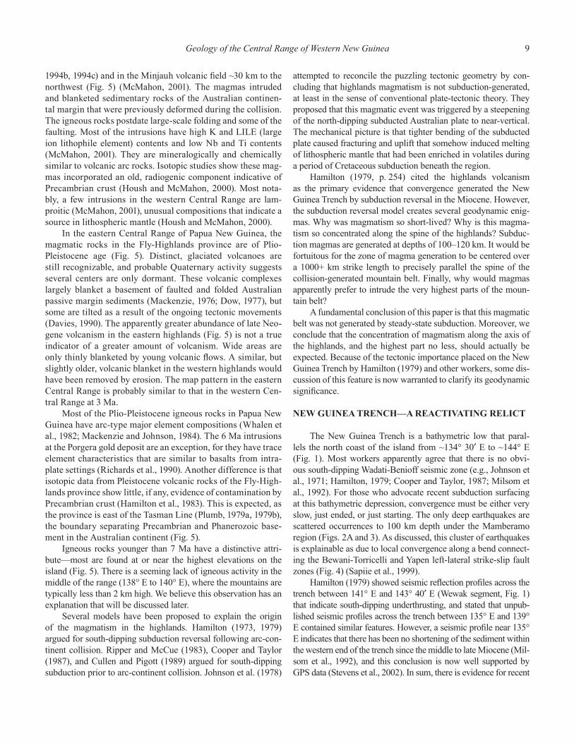
Hamilton (1979, p. 254) cited the highlands volcanism as the primary evidence that convergence generated the New Guinea Trench by subduction reversal in the Miocene. However, the subduction reversal model creates several geodynamic enig-mas. Why was magmatism so short-lived? Why is this magma-tism so concentrated along the spine of the highlands? Subduc-tion magmas are generated at depths of 100–120 km. It would be fortuitous for the zone of magma generation to be centered over a 1000+ km strike length to precisely parallel the spine of the collision-generated mountain belt. Finally, why would magmas apparently prefer to intrude the very highest parts of the moun-tain belt?
A fundamental conclusion of this paper is that this magmatic belt was not generated by steady-state subduction. Moreover, we conclude that the concentration of magmatism along the axis of the highlands, and the highest part no less, should actually be expected. Because of the tectonic importance placed on the New Guinea Trench by Hamilton (1979) and other workers, some dis-cussion of this feature is now warranted to clarify its geodynamic signifi cance.
NEW GUINEA TRENCH—A REACTIVATING RELICT
The New Guinea Trench is a bathymetric low that paral-lels the north coast of the island from ~134° 30′ E to ~144° E (Fig. 1). Most workers apparently agree that there is no obvi-ous south-dipping Wadati-Benioff seismic zone (e.g., Johnson et al., 1971; Hamilton, 1979; Cooper and Taylor, 1987; Milsom et al., 1992). For those who advocate recent subduction surfacing at this bathymetric depression, convergence must be either very slow, just ended, or just starting. The only deep earthquakes are scattered occurrences to 100 km depth under the Mamberamo region (Figs. 2A and 3). As discussed, this cluster of earthquakes is explainable as due to local convergence along a bend connect-ing the Bewani-Torricelli and Yapen left-lateral strike-slip fault zones (Fig. 4) (Sapiie et al., 1999).
Hamilton (1979) showed seismic refl ection profi les across the trench between 141° E and 143° 40′ E (Wewak segment, Fig. 1) that indicate south-dipping underthrusting, and stated that unpub-lished seismic profi les across the trench between 135° E and 139° E contained similar features. However, a seismic profi le near 135° E indicates that there has been no shortening of the sediment within the western end of the trench since the middle to late Miocene (Mil-som et al., 1992), and this conclusion is now well supported by GPS data (Stevens et al., 2002). In sum, there is evidence for recent
10 M. Cloos et al.
convergence (a few tens of km?) along the eastern end of the New Guinea Trench, but not at the western end.
Even more problematical from a tectonics perspective is the fact that the eastern end of the trench lies to the west of most of the Pleistocene volcanoes of the Fly-Highlands province in Papua New Guinea (Fig. 5). Hamilton (1979) and Cooper and Taylor (1987) suggested that south-dipping subduction on the New Guinea Trench was somehow linked to that on the Trobri-and Trough in easternmost New Guinea, north of the Bird’s Tail (Fig. 1). This does not, however, explain the westward truncation of the Neogene Bismarck Arc at 145° E, which, in their models, overrides the north-facing trench. This geometry is perplexing in the context of any subduction reversal model. It will be shown that magmatism related to north-dipping subduction of the Aus-tralian plate, in essence the geometry proposed by Johnson et al. (1978), is the only tectonic scenario proposed to date that is com-patible with all the fi eld relations.
In short, there is no kinematic evidence that 100+ km of underthrusting occurred at the New Guinea Trench since ca. 10 Ma—an age for subduction initiation required to explain the old-est volcanics in the highlands. In addition, a subduction reversal model does not explain why supposed arc volcanism ended at ca. 3 Ma in the western highlands, or the recent activity in the eastern highlands.
All of the above leads us to believe that Kroenke (1984) is correct in deducing that the New Guinea Trench is a relict of an earlier period of subduction. He concluded this trench was the site of south-dipping subduction from the Eocene to early Mio-cene. This caused magmatism forming the now accreted Outer Melanesian Arc Terrane that fi rst started to form at ca. 43 Ma, when Pacifi c plate motion changed and subduction began along major fracture zones along the western Pacifi c from New Zea-land to Japan (Hilde et al., 1977; Parrot and Dugas, 1980; Casey and Dewey, 1984). The seismic refl ection profi les along the east-ern part of the New Guinea Trench (140° E to 145° E) indicate at least some recent convergence (Hamilton, 1979). However, just a few kilometers of underthrusting can account for all observations known to us. It is concluded that the eastern end of the trench has been reactivated as the latest tectonic adjustment associated with arc/forearc-continent collision. In other words, subduction rever-sal (reactivation) is just beginning at the eastern end of the New Guinea Trench and has yet to produce arc magmatism.
GEOLOGIC TRANSECT—WESTERN CENTRAL RANGE
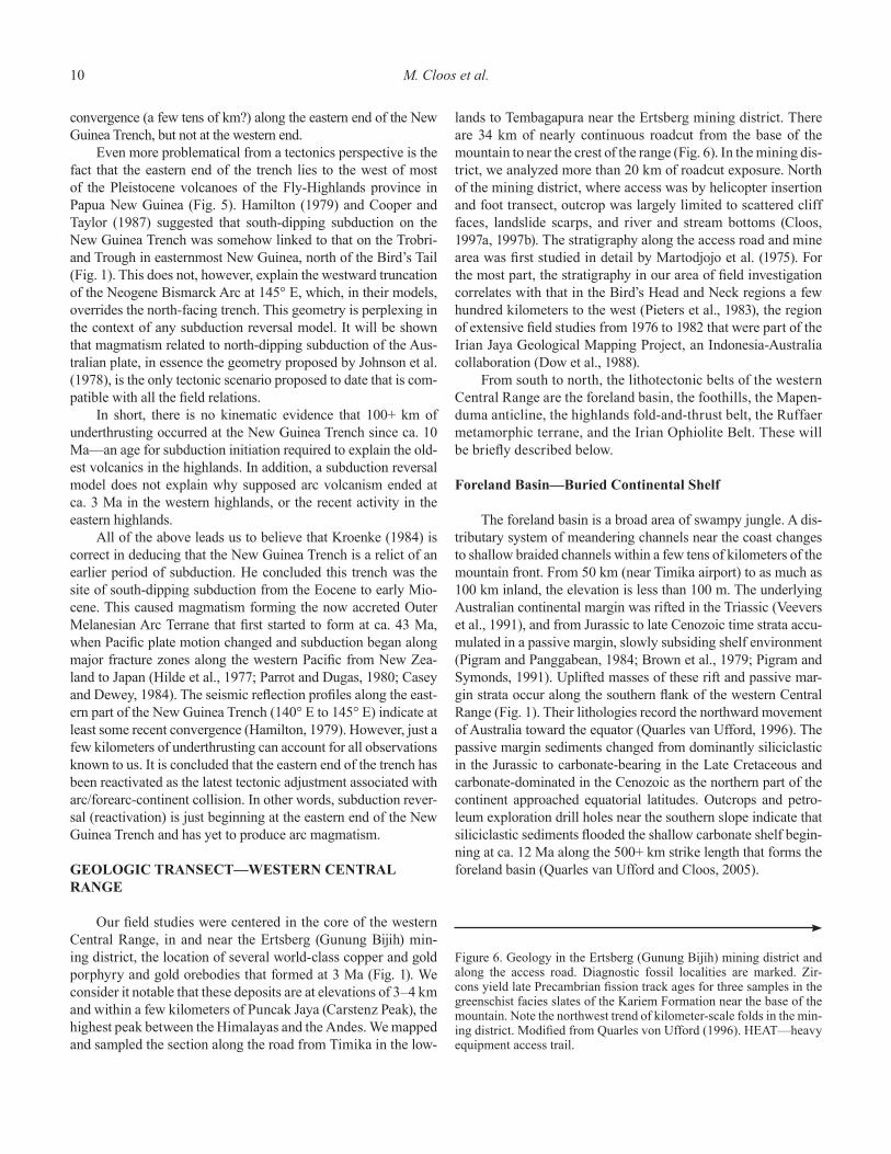
Our fi eld studies were centered in the core of the western Central Range, in and near the Ertsberg (Gunung Bijih) min-ing district, the location of several world-class copper and gold porphyry and gold orebodies that formed at 3 Ma (Fig. 1). We consider it notable that these deposits are at elevations of 3–4 km and within a few kilometers of Puncak Jaya (Carstenz Peak), the highest peak between the Himalayas and the Andes. We mapped and sampled the section along the road from Timika in the low-
lands to Tembagapura near the Ertsberg mining district. There are 34 km of nearly continuous roadcut from the base of the mountain to near the crest of the range (Fig. 6). In the mining dis-trict, we analyzed more than 20 km of roadcut exposure. North of the mining district, where access was by helicopter insertion and foot transect, outcrop was largely limited to scattered cliff faces, landslide scarps, and river and stream bottoms (Cloos, 1997a, 1997b). The stratigraphy along the access road and mine area was fi rst studied in detail by Martodjojo et al. (1975). For the most part, the stratigraphy in our area of fi eld investigation correlates with that in the Bird’s Head and Neck regions a few hundred kilometers to the west (Pieters et al., 1983), the region of extensive fi eld studies from 1976 to 1982 that were part of the Irian Jaya Geological Mapping Project, an Indonesia-Australia collaboration (Dow et al., 1988).
From south to north, the lithotectonic belts of the western Central Range are the foreland basin, the foothills, the Mapen-duma anticline, the highlands fold-and-thrust belt, the Ruffaer metamorphic terrane, and the Irian Ophiolite Belt. These will be briefl y described below.
Foreland Basin—Buried Continental Shelf
The foreland basin is a broad area of swampy jungle. A dis-tributary system of meandering channels near the coast changes to shallow braided channels within a few tens of kilometers of the mountain front. From 50 km (near Timika airport) to as much as 100 km inland, the elevation is less than 100 m. The underlying Australian continental margin was rifted in the Triassic (Veevers et al., 1991), and from Jurassic to late Cenozoic time strata accu-mulated in a passive margin, slowly subsiding shelf environment (Pigram and Panggabean, 1984; Brown et al., 1979; Pigram and Symonds, 1991). Uplifted masses of these rift and passive mar-gin strata occur along the southern fl ank of the western Central Range (Fig. 1). Their lithologies record the northward movement of Australia toward the equator (Quarles van Ufford, 1996). The passive margin sediments changed from dominantly siliciclastic in the Jurassic to carbonate-bearing in the Late Cretaceous and carbonate-dominated in the Cenozoic as the northern part of the continent approached equatorial latitudes. Outcrops and petro-leum exploration drill holes near the southern slope indicate that siliciclastic sediments fl ooded the shallow carbonate shelf begin-ning at ca. 12 Ma along the 500+ km strike length that forms the foreland basin (Quarles van Ufford and Cloos, 2005).
Figure 6. Geology in the Ertsberg (Gunung Bijih) mining district and along the access road. Diagnostic fossil localities are marked. Zir-cons yield late Precambrian fi ssion track ages for three samples in the greenschist facies slates of the Kariem Formation near the base of the mountain. Note the northwest trend of kilometer-scale folds in the min-ing district. Modifi ed from Quarles von Ufford (1996). HEAT—heavy equipment access trail.
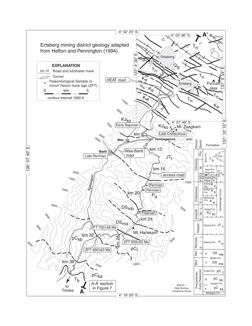
Figure 7. A: Cross section A–A′ located on Figure 6. Note the homoclinal north limb of the Mapenduma anticline. The Ertsberg intrusion in the mining district is dated at 3 Ma and crosscuts the kilometer-scale folds (McDowell et al., 1996). B: Interpreted movement history for the formation of the Mapenduma anticline based upon apatite fi ssion track thermochronology (after Weiland and Cloos, 1996). Initial thin-skinned folding changed to thick-skinned basement-involved deformation. It is likely the Mapenduma anticline formed by reactivating a steeply dipping Mesozoic normal fault. Formation abbreviations as on Figure 6.
Geology of the Central Range of Western New Guinea 13
Foothills—Leading Edge of Central Range Orogenic Belt
The foothills, with elevations less than 500 m, are located between the fl at-lying foreland and the jagged front of the moun-tain. West of the mine access road, the foothills include low-relief folds (Sabins, 1983; Pigram and Panggabean, 1983). Along the access road to the mining district, the foothills are underlain by two broad terraces composed of gently south-dipping conglom-eratic alluvium, the upper Buru Formation (Quarles van Ufford, 1996). Approximately 10 km to the west and the east, upturned beds of lower Buru (ca. 12 to ca. 4 Ma) and older formations are folded and exposed by erosion (Parris, 1994).
The base of the Buru Formation (and equivalent formations to the west and east) are conformable with the shelf limestones of the New Guinea Limestone Group (Bär et al., 1961; Pigram and Panggabean, 1983). Tilting of the lower Buru deposits indicates the older foreland basin deposits were folded or overridden by thrust blocks. The fl at-lying upper Buru Formation (younger than ca. 4 Ma) indicates the fl anks of the mountain were locally buried in conglomeratic debris (molasse) as movement slowed.
Mapenduma Anticline—Thick-Skinned Deformation
The most prominent structure along the southern fl ank of the western Central Range (Fig. 1) is the 280°-trending, ~300 km long basement-cored Mapenduma anticline (Nash et al., 1993, Fig. 4 therein). This anticline is the only structure in the southwestern Central Range that exposes Precambrian or early Paleozoic sediments and metasediments (Tuaba and Kariem Formations) and metaigneous basement (Awitagoh Formation) (Fig. 7). Deep erosion has removed the south limb of the Map-enduma anticline at the location of the mine access road. The structure has been confi rmed through fi eld mapping to extend for ~200 km to the east and 100 km to the west of the road (Par-ris, 1994).
Biostratigraphic analyses have detected no stratigraphic repetitions along the mine access road, where the 15 km wide, north-dipping homoclinal limb of the Mapenduma anticline is exposed (Figs. 7A and 8) (Quarles van Ufford, 1996). Dozens of outcrop-scale folds occur, but major folding (>100 m ampli-tude) is not recognized in the Precambrian to Triassic strata. Kilometer-scale folding and limited stratigraphic repetition by faulting is obvious near the southern crest of the range in the Jurassic and younger formations. Bedding dips and formation thicknesses indicate that at least 8 km of stratigraphic thickness and as much as 12 km of structural thickness are exposed on the north limb of the Mapenduma anticline (Fig. 7A) (Quarles van Ufford, 1996; Weiland and Cloos, 1996).
The southern boundary of the Mapenduma anticline must be a thrust fault (Parris, 1994). The Precambrian or early Paleo-zoic Kariem Formation is structurally higher than the Mesozoic Kembelangan Group east of the mine access road. The regional tilt of beds on the north limb is consistent with a giant 30 km wide fault-bend fold above an ~30°, north-dipping thrust ramp.
>200 m~
Modio Fm.
B
A
~~
~
~~
rr
Tuaba Fm.
r r
Tipuma Fm.
r
v v Awitagoh Fm.
Aiduna Fm.
Kariem Fm.
Piniya Fm.
Ekmai SS.
A
Bur
u F
m.v
~ v v~
r r
B
r
r
Kopai Fm.
WoniwogiFm.
v
Waripi Fm.
Kais Fm.
Lithology Formation
Sirga Fm.
Faumai Fm.
New
Gui
nea
LS G
roup
Kem
bela
ngan
Gro
up
Thickness
v
v
vv v
vVolc.
3850±1000 m
2250
±60
0 m
1600
±40
0 m
950±100 m
2000±400 m95
0±20
0 m
1050
±20
0 m
1750±200 m
2000±400 m
1400±300 m
1000±200 m
1550±300 m
650±100 m
4600
±100
0 m
350 m300 m
40 m1100 m
1800
m
~60
00 m ?
EP
reca
mbr
ian
- E
arly
Pal
eozo
icS
ilur
EL
Dev L
Per
mia
nTr
iass
icJu
rass
ic
EM
L
Cre
tace
ous
Cen
ozoi
c
PO
MP
lioL
E
Per
iod
Epo
ch
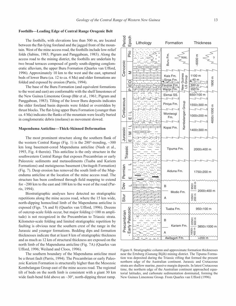
Figure 8. Stratigraphic column and approximate formation thicknesses near the Ertsberg (Gunung Bijih) mining district. The Tipuma Forma-tion was deposited during the Triassic rifting that formed the present northern edge of the Australian continent. Jurassic and Cretaceous strata are shallow marine, passive margin deposits. In latest Cretaceous time, the northern edge of the Australian continent approached equa-torial latitudes, and carbonate sedimentation dominated, forming the New Guinea Limestone Group. From Quarles van Ufford (1996).
14 M. Cloos et al.
Southward movement along the Mapenduma thrust fault can only be estimated. Assuming the basal detachment is currently at a depth of 15 km, a displacement of ~35 km is required to explain the map pattern. At the base of the ramp, a décolle-ment would have been at a depth of 20–25 km when movement started, that is, within the lower crust. An average rainfall along the southern fl ank of the western Central Range of ~10 m per year causes deep erosion of the southern limb (Fig. 7B). Apatite fi ssion track thermochronology indicates the mid-slope region has been unroofed at rates of 1–2 km/m.y. since the end of the Pliocene. Erosional unroofi ng of the southern fl ank of the anti-cline began at ca. 7 Ma (Weiland and Cloos, 1996).
The ramp forming the Mapenduma anticline is believed to be a reactivated normal fault that formed during early Mesozoic rifting. In Papua New Guinea, abundant well and gravity data reveal the presence of Mesozoic normal faults in the subsur-face. They parallel the 310° local trend of the orogen (Fig. 1) (Australasian Petroleum Company, 1961; St. John, 1970; Ridd, 1976; Hobson, 1986). In the eastern Central Range, reverse reactivation of normal faults has been called upon to explain the location of three basement-cored structures that are tens of kilometers wide (Hill, 1991). The trend of the southern fl ank of the Central Range appears to be nearly parallel to the trend of underlying Mesozoic rift structures. Thus, exposure of Paleo-zoic, Mesozoic, and Cenozoic strata in the Mapenduma fold-and-thrust structure is most simply explained as due to reacti-vation of a 280°-trending normal fault zone in the crystalline basement during late Miocene collisional orogenesis and sub-sequent denudation.
Folds in the Southern Central Range—Thin-Skinned Deformation
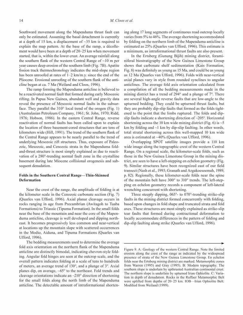
Near the crest of the range, the amplitude of folding is at the kilometer scale in the Cenozoic carbonate section (Fig. 7) (Quarles van Ufford, 1996). Axial planar cleavage occurs in rocks ranging in age from Precambrian (Awitagoh to Tuaba Formations) to Triassic (Tipuma Formation). In the small folds near the base of the mountain and near the core of the Mapen-duma anticline, cleavage is well developed and dipping north-east. It becomes progressively less common and near-vertical at locations up the mountain slope with scattered occurrences in the Modio, Aiduna, and Tipuma Formations (Quarles van Ufford, 1996).
The bedding measurements used to determine the average fold axis orientation on the northern fl ank of the Mapenduma anticline are distinctly bimodal, indicating chevron-style fold-ing. Angular fold hinges are seen at the outcrop scale, and the overall pattern indicates folding at a scale of tens to hundreds of meters, an average trend of 130°, and a plunge of 3°. Axial planes dip, on average, ~65° to the northeast. Fold trends and cleavage orientations indicate an ~210° direction of shortening for the small folds along the north limb of the Mapenduma anticline. The detectable amount of intraformational shorten-
ing along 17 long segments of continuous road outcrop locally varies from 5% to 46%. The average shortening accommodated by folding on the northern limb of the Mapenduma anticline is estimated as 25% (Quarles van Ufford, 1996). This estimate is a minimum, as intraformational thrust faults are also present.
In the Ertsberg (Gunung Bijih) mining district, forami-niferal biostratigraphy of the New Guinea Limestone Group shows that carbonate shelf sedimentation (Kais Formation, Fig. 8) was defi nitely as young as 15 Ma, and could be as young as 12 Ma (Quarles van Ufford, 1996). Folds with near-vertical axial planes vary in style from rounded synclines to angular anticlines. The average fold axis orientation calculated from a compilation of all the bedding measurements made in the mining district has a trend of 294° and a plunge of 7°. There are several high-angle reverse faults that are low-angle to the upturned bedding. They could be upturned thrust faults, but they are probably dip-slip faults that formed as the folds tight-ened to the point that the limbs ruptured. The folds and dip-slip faults indicate a shortening direction of ~205°. Horizontal shortening across the 10 km wide mining district (Fig. 6) is ~5 km by folding and ~1 km by dip-slip faulting. In other words, total stratal shortening across this well-mapped 10 km wide area is estimated at ~40% (Quarles van Ufford, 1996).
Overlapping SPOT satellite images provide a 110 km wide image along the topographic crest of the western Central Range. On a regional scale, the kilometer-scale folds, such as those in the New Guinea Limestone Group in the mining dis-trict, are seen to have a left-stepping en echelon geometry (Fig. 9). Similar structures have been recognized east of our fi eld transect (Nash et al., 1993; Granath and Argakoesoemah, 1989, p. 82). Regionally, these kilometer-scale folds near the spine of the mountain belt have 300° to 310° trends. The left-step-ping en echelon geometry records a component of left-lateral wrenching concurrent with shortening.
Three steeply dipping, 065°- to 070°-trending strike-slip faults in the mining district formed concurrently with folding, based upon changes in fold shape and truncated strata and fold axes. These structures are most simply explained as strike-slip tear faults that formed during contractional deformation to locally accommodate differences in the pattern of folding and dip-slip faulting along strike (Quarles van Ufford, 1996).
Figure 9. A: Geology of the western Central Range. Note the limited erosion along the crest of the range as indicated by the widespread presence of strata of the New Guinea Limestone Group. En echelon folds near the Ertsberg mining district are marked. Metamorphic zones from Warren (1995) and Gray (1995). B: Modern topography. The southern slope is underlain by upthrusted Australian continental crust. The northern slope is underlain by upturned Irian Ophiolite. C: Varia-tion in depth of denudation. Rocks in the Ruffaer Metamorphic Belt were uplifted from depths of 20–25 km. IOB—Irian Ophiolite Belt. Modifi ed from Weiland (1999).

Geology of the Central Range of Western New Guinea 15
A
B
C
16 M. Cloos et al.
Sapiie (1998) and Sapiie and Cloos (2004) provide an anal-ysis of faulting in the mining district. Exceptional exposures along mine roads revealed a comparatively minor, left-lateral Riedel shear strike-slip system developed with a trend parallel-ing the ~300° local structural grain generated by the upturned bedding. Contractional deformation in the mining district must have largely, if not entirely, ended by late Pliocene time, as the 3 Ma Grasberg intrusion is a nearly circular plug that crosscuts the axis of a kilometer-scale fold in the Ertsberg mining dis-trict (Fig. 6). The left-lateral strike-slip system was concurrent with the igneous activity in the district that occurred from 4.4 to 2.6 Ma (McDowell et al., 1996). This faulting created path-ways for intrusion and focused the fl ow of hydrothermal fl uids forming orebodies (Sapiie, 1998). Several contraction-gener-ated dip-slip faults were reactivated as left-lateral, strike-slip faults. This distinctive structural episode caused a cumulative left-lateral offset across the mining district of a kilometer or two at most (Sapiie, 1998).
Ruffaer Metamorphic Belt—Metamorphosed Passive Margin Strata
The distribution of metamorphic rocks in the western Cen-tral Range, the Ruffaer Metamorphic Belt, was fi rst mapped by Dow et al. (1986) and Nash et al. (1993) using satellite imagery and aerial photographs confi rmed with limited fi eld transects. The fi rst systematic petrologic studies of this slate and phyllite terrane were by Warren (1995) and Gray (1995) (Fig. 9). They showed that protoliths for most metamorphic rocks were simi-lar to the Jurassic and Cretaceous shales and siltstones exposed in the fold-and-thrust belt. Several Cretaceous ammonites were found in the slate belt (Warren, 1995). The presence of parago-nite, phengitic muscovite, chloritoid, spessartine garnet, and the near absence of biotite indicate high-pressure greenschist facies metamorphism (Fig. 9). Maximum temperature and pressure estimates for the slates and phyllites are in the range of 250–350 °C and 5–8 kbar (corresponding to maximum depths of ~25 km). The southern part of the belt is slate, whereas the northern part is locally phyllitic. This observation, combined with increasing illite crystallinity, widespread paragonite, and scattered occur-rence of spessartine garnet and chloritoid in the northern part of the belt, indicates the Irian Ophiolite Belt to the north was the heat source that caused metamorphism.
Weiland (1999) provided the fi rst geochronological study of the belt. Whole-rock K-Ar ages for 15 samples with strong pre-ferred orientations and petrographic evidence of thorough recrys-tallization are between 28 and 20 Ma. This age range is consid-ered the time of peak metamorphic temperatures. A single sample was coarse-grained enough for complete mineral separation, and a K-Ar white mica age of 21 Ma was obtained. We conclude that metamorphic recrystallization in the exposed rocks started at ca. 28 Ma, with northward subduction beginning slightly earlier. By ca. 20 Ma, the forearc region had suffi ciently cooled that meta-morphic recrystallization driven by residual heat in the forearc
block had ended, at least for those rocks in the belt now exposed at the surface (thermal evolution of subduction zones discussed in Cloos, 1985).
Based on fi eld study and laboratory analysis of more than 200 outcrop samples from across and along this belt, the bound-ary of the Ruffaer Metamorphic Belt with the highlands fold-and-thrust belt to the south is gradational (Fig. 9) (Warren, 1995; Gray, 1995). Locally, the Derewo fault zone juxtaposes meta-morphosed and unmetamorphosed Jurassic to Cretaceous rocks of the Kembelangan Group (Warren, 1995). This fault is recog-nized as a major structure because it forms an easily identifi able 200 km long straight valley extending roughly east-west. Nash et al. (1993) suggest the Derewo fault zone is a north-dipping reverse fault separating metamorphosed and unmetamorphosed rocks, based primarily upon interpretation of satellite imagery. Field-based observation in the Ruffaer Metamorphic Belt led Warren (1995) to conclude that the Derewo fault zone is a near-vertical strike-slip fault zone that only locally marks the bound-ary between metamorphosed and unmetamorphosed rocks. The magnitude of offset is unknown, but its length suggests move-ment of at least 10 km and, more likely, several tens of kilome-ters. A left-lateral sense of slip is inferred for the Derewo fault zone by analogy with the Sorong-Yapen fault zones to the north and late-stage strike-slip faulting to the south in the mining dis-trict (Sapiie and Cloos, 2004).
Irian Ophiolite Belt—Accreted Oceanic Lithosphere
The Irian Ophiolite Belt in the western Central Range was mapped using imagery by Dow et al. (1986). The fi rst petrologic study for rocks from the Irian Ophiolite was by Weiland (1999), who made three fi eld transects in the belt. He found serpentinized ultramafi cs at the higher elevations along the southern part of the belt. Rodingitic mafi c dikes occur in some outcrops. The north-ern fl ank, in the swampy lowlands, is composed of mafi c intru-sives and volcanic rocks. Outcrops are very scarce in the deeply weathered basalts.
The structural setting indicates that the Irian Ophiolite Belt, like the Papuan Ophiolite Belt in the Bird’s Tail region (Davies, 1971), is a slab of ocean crust and upper mantle that has been uplifted and tilted northwards ~30°. The southern edge has been unroofed to mantle depths, that is, from at least 7 km beneath the ocean fl oor (Fig. 9). Because Jurassic seafl oor was probably at water depths of ~5 km, the ultramafi c rocks now occurring at elevations of 1 km must have risen at least 13 km.
The ophiolite belt contains scattered occurrences of horn-blende amphibolite (Warren, 1995) that yield Jurassic Ar isotopic ages (Weiland, 1999). These black rocks form very distinctive cobbles in the river deposits. The hornblende-plagioclase ± gar-net assemblage indicates that these cobbles are mafi c rocks that became foliated and lineated at temperatures of 500–800 °C and at pressures less than 5 kbar—high-temperature/low-pressure con-ditions (Warren, 1995). Weiland (1999) concluded this dynamic amphibolite facies metamorphism occurred at a location far out in
Geology of the Central Range of Western New Guinea 17
the Pacifi c Basin where crustal slices or mafi c dikes were caught in an oceanic transform fault zone near the formative spreading ridge. Similar gneissic amphibolites have been dredged along the Mid-Atlantic Ridge (Honnorez et al., 1984).
Dioritic plutons with arc-type chemistry are present in the western and eastern parts of the Irian Ophiolite Belt (Weiland, 1999). In the northwesternmost corner of the belt, there are the previously mentioned occurrences of plutons and volcanics of Maramuni age (20–10 Ma), for which the structural setting is unclear (Fig. 9). There is no known evidence that this magmatic complex was intruded into the ultramafi c rock exposed to the south. We suspect that this magmatic complex is an alloch-thonous sheet thrust onto the back of the Irian Ophiolite Belt (this interpretation is shown on Fig. 9). A similar imbrication is documented in the much better studied and exposed Weyland overthrust to the west, where arc-type magmatic rocks were thrust on top of the highlands fold belt (Dow and Sukamto, 1984a; Dow et al., 1988; Dow et al., 1990). We also believe that these occurrences, along with the Cenderawasih Bay embayment, are recent and probably still developing structural complications at the western end of the Central Range. The most recent movements are manifestations of the switch of the Bird’s Head block from the Australian plate to the Pacifi c plate (see earlier discussion).
In the eastern portion of the Irian Ophiolite Belt, a dioritic plutonic complex is intruded into the ultramafi c terrane. K-Ar hornblende and biotite ages of 35–28 Ma have been obtained for part of this complex near Dabera (Fig. 9) (Weiland, 1999). This plutonic complex must have formed during the episode of south-dipping subduction that formed the New Guinea Trench (Weiland, 1999). The presence of the Dabera plutonic complex at the leading edge of the forearc block indicates that north-dip-ping subduction beneath the Outer Melanesian Arc started at ca. 30 Ma. Rupture initiation was by subduction reversal along the axis of the line of arc volcanism (Quarles van Ufford and Cloos, 2005). This is mechanically reasonable, if not expected, because arc plutonism would thermally weaken this zone of lithosphere. Another effect is that when still-hot arc terrane becomes the leading edge, or forearc block, of a new subduction zone, it has a high heat content. This, in turn, causes higher than typical peak temperatures for a given depth and increases the total volume of rock affected by metamorphic recrystallization during the initia-tion of north-dipping subduction. Along with modest subduction speeds of ~5 cm/yr, the presence of cooling plutons and thus an abnormal heat content in the hanging wall of the new subduc-tion zone would explain why slates and phyllites of the Ruf-faer Metamorphic Belt attained high-pressure greenschist facies metamorphic rocks.
An important fi eld relation concerning sedimentation of the Irian Ophiolite Belt forearc basement occurs in the Mam-beramo region near the international border (Fig. 1). The Makats Formation contains abundant siliciclastic debris. The base of this formation is early Middle Miocene (16–14 Ma) (Visser and Hermes, 1962, p. 100–111). This unit records when subduction
deformation fi rst caused one or more islands to emerge near the junction of the plates (the forearc high). The Makats Formation is reported to contain clasts of “metamorphic rocks, mica schist, [and] slates …” (Visser and Hermes, 1962, p. 100–106) indi-cating deep (>10± km) denudation of the source landmass. The fi rst appearance of metamorphic detritus is of great interest, for this would place important constraints on the rate of unroofi ng. Unfortunately, the age of the fi rst strata containing metamorphic debris is uncertain. Nonetheless, the middle Miocene age of the basal Makats deposits indicates a substantial supply of silici-clastic sediment to the south that was transported north into the forearc basin. These biostratigraphic data indicate that landmass erosion began at ca. 15 Ma. This precedes, by several million years, the beginning of widespread synorogenic sedimentation to the south and on the Australian continental basement at ca. 12 Ma (Quarles van Ufford and Cloos, 2005).
SHORTENING ESTIMATES AND PLATE-TECTONIC RATES
The magnitude of shortening recorded by observed folding and detectable thrust imbrication in the western highlands is estimated to be ~80 km over the 120 km width of the western Central Range (Quarles van Ufford, 1996). In the eastern high-lands of Papua New Guinea, regional shortening is dominated by thrust imbrication with subsidiary folding (Hobson, 1986). The amount is estimated as ~100 km (Hill, 1991). These are obviously minimum estimates, as undetected structures must be present. Even if the shortening was 200 km, this move-ment is but a small fraction of the total convergence between the Pacifi c and Australian plates along the trend of the Central Range since 25 Ma.
The Central Range developed in an obliquely convergent setting. The plate margin orientation at the time of subduction initiation is uncertain, but it probably was northwest-trending. The strike of the western Central Range is ~N80W. The trend of folds in the western highlands is N55W. Taking the average trend of these strike orientations, and a relative plate motion vec-tor of 9 cm/yr along an azimuth of S65W (from Scotese et al., 1988), the normal component of convergence is calculated as ~50 km/m.y. and the strike-parallel component as 70 km/m.y. for the period of at least 30–4 Ma. At this rate, the measured 80–100 km of shortening (or even 200 km) across the highlands fold-and-thrust belts could have easily occurred in less than 4 m.y. As with all other subduction zones, most of the convergence is not directly recorded in the geology of the accretionary complex.
Prior to the subduction of the edge of the Australian conti-nent, convergence was accommodated by movements in a shear zone (the subduction channel as defi ned by Shreve and Cloos, 1986) beneath the accreted rocks forming the metamorphic belt. Once deformation of continental rise strata began, a progressively thickening layer of passive margin sediments was bulldozed. The top part was accreted, and the basal section, several hundred meters in thickness, was subducted to mantle depths. Accretion
18 M. Cloos et al.
by offscraping widens an accretionary complex, whereas under-plating adds to the base and thickens it (see Cloos and Shreve, 1988a, 1988b, for more details). Using this terminology, the rocks of the Ruffaer Metamorphic Belt were underplated beneath the ophiolite belt. The estimate of 200 km of shortening in the fold-and-thrust belt only applies to deformed shelf deposits and, thus, to convergence after continental crust began to underthrust. Therefore, many hundreds of kilometers of intraoceanic subduc-tion must have previously occurred to account for the previous 20+ m.y. of convergence.
Overall, folds in the western Central Range trend ~40° oblique to the direction of plate convergence. Oblique conver-gence readily accounts for the generation of left-stepping en echelon fold trains in the core of the highlands. The extent to which the folds rotated to their present orientation is probably 10°–20°, but this is uncertain. One phenomenon is clear in the
core of the western highlands: Once collision began and crystal-line basement became uprooted, the transcurrent component of motion began to manifest itself as northwest-trending, left-lat-eral, strike-slip faulting (Sapiie and Cloos, 2004). As will be seen, the delamination of the lithospheric mantle and the change in the force balance on the edge of the Pacifi c plate as collisional oro-genesis progressed worked in concert to cause a distinct change in structural response.
In this chapter, the pattern and timing of sedimentation, metamorphism, magmatism, and deformation was summarized for the western Central Range of New Guinea. Any model for the tectonic evolution of western New Guinea must account for these observations. In Chapter 2, mechanical concepts are discussed and summarized to provide a basis for predicting the response of the underlying lithospheric mantle during the subduction of a continental margin.

19
LITHOSPHERIC DELAMINATION
The basic concept that lithospheric mantle could separate and sink away from continental crust was fi rst proposed by Bird (1978). The “delamination” process was invoked to explain the timing of metamorphism and the generation of synorogenic magmas in the core of the Himalayas (Fig. 10A). Bird (1979) proposed that delamination was also a simple explanation for the vertical uplift of the Colorado Plateau and associated sparse magmatism.
According to Bird (1978, 1979), lithospheric mantle can peel away from the overlying continental crust and sink vertically because it is cooler and more dense than the underlying astheno-sphere. The rate of delamination tearing depends strongly upon the viscosity of the asthenosphere that must fl ow into the propa-gating crack (Bird and Baumgardner, 1981). A similar sinking trajectory is shown in the delamination models of Collins (1994) and Collins and Vernon (1994). A variant of this process was proposed by Houseman et al. (1981), Platt and England (1994), and Schott and Schmeling (1998). These workers concluded that thickened roots of lithospheric mantle form under contractional orogenic belts. It is envisioned that where overthickened masses of cold lithospheric mantle are generated, blobs detach as “litho-spheric drips” that sink vertically into the asthenosphere.
Sacks and Secor (1990) proposed that following the jam-ming of a subduction zone by a continent or thick arc complex, the subducted plate would continue to sink along its previous inclined trajectory (Fig. 10B). They argue that the overall force balance driving the subducted end of the plate downwards is changed little by the collisional jamming. Consequently, a subter-ranean rifting of the subducted lithosphere must nucleate where plate bending is tightest. By analogy to continental rifting, both “pure-shear” ductile necking and “simple-shear” detachment faulting were considered to be possible end members of this rift-ing behavior.
Plate rupture and sinking along an inclined trajectory has been termed “slab breakoff” by Davies and von Blanckenburg (1995) and von Blanckenburg and Davies (1995). In their model, they make a force balance / lithosphere strength analysis that leads them to envision that rupture occurs by a crack propagat-ing upwards from the base and nearly perpendicular to the plate (Fig. 10C). They also conclude that rupture does not localize in the region of tightest bending, rather it occurs at greater depths where subduction speeds remain faster.
We concluded that subterranean plate rifting must also have occurred in the subducting Australian lithosphere beneath the
Geological Society of AmericaSpecial Paper 400
2005
Chapter 2
Mechanics of Subducting Slab Breakoff by Collisional Delamination
Central Range of New Guinea. Cloos et al. (1994) referred to this process as “collisional delamination.” We believe delamination is the preferable descriptor of the slab breakoff process, for it implies that separation is strongly infl uenced by the mechanical anisotropies in the lithosphere. It will be argued that the mechani-cal layering of the sedimentary cover, the crystalline crust, and the mantle each play a predictable role in controlling the struc-tural evolution before and during collisional orogenesis at a sub-
Figure 10. Models for lithospheric delamination in collisional moun-tain melts. A: Himalayan orogen (Bird, 1978, Fig. 9 therein). B: Ap-palachian orogen (Sacks and Secor, 1990, Fig. 1 therein). C: European Alps (Davies and von Blanckenburg, 1995, Fig. 1 therein). Note the differing ways in which plate rupture is envisioned to occur.
20 M. Cloos et al.
duction zone—a sequence of events well recorded in the geology of western New Guinea. Two distinctive geologic phenomena are well recorded in the rock record of New Guinea that constrain the timing of collisional delamination. They also should be found in and near more ancient, deeply eroded, collisional orogenic belts: late-stage igneous activity along the axis of the orogenic belt and profound changes in regional sedimentation patterns.
RUPTURE OF THE LITHOSPHERE
Our fi eld observations and isotopic ages summarized earlier are the basis for reconstructing the timing of geologic events at and near Earth’s surface during the collision forming the Cen-tral Range of western New Guinea. The mechanical response of materials at depth must be inferred. On this subject, our kinematic picture of lithospheric behavior differs signifi cantly from that of previous workers who advocate delamination or slab breakoff as a tectonic process. For this reason, our mechanical reasoning is described in detail below.
Fracture and Flow
There are four end-member rheological behaviors in the solid earth: elastic, brittle, plastic, and viscous. On the short time scales of seismic wave propagation, the entire earth responds elastically, or largely so. Earthquakes and brittle behavior involve planar faults. Plastic and viscous behaviors are both forms of dis-tributed fl ow.
Where earth materials are suffi ciently cool (<300–400 °C), differential stress (σ
1 – σ
3) and resultant elastic strains can slowly
build up over time scales of years to centuries. When the differ-ential stresses exceed the fracture strength or, much more com-monly, the frictional resistance to renewed slip on planes of weak-ness (fault reactivation), rapid movement occurs, and earthquake waves are generated. Ruptures commonly propagate upward into zones of weak materials that are only able to sustain small differ-ential stress between events (e.g., Cloos, 1992a). Displacement along faults involves friction, and thus, resistance increases with increasing normal stress on the slip planes. Higher fl uid pressure can lessen and even entirely negate the effects of higher confi n-ing pressure because it proportionately decreases the “effective” normal stresses (Hubbert and Rubey, 1959).
Conventional fracture strength analysis is rooted in Mohr-Coulomb theory. This analysis appears to apply fairly well for short-term phenomena such as the rapid loading of rocks by earthquake-generating movements, but in the case of orogenic processes occurring over million-year time scales, it only pro-vides an upper limit on the differential stress that can be sus-tained. There are signifi cant, but poorly calibrated, time-depen-dent effects that cause fractures to form at “subcritical” differen-tial stresses (Atkinson, 1987). The fi eld of engineering fracture mechanics is well established but essentially undeveloped for processes occurring on geologic time scales. Nonetheless, long-term fracture strengths should be linearly, or nearly so, depen-
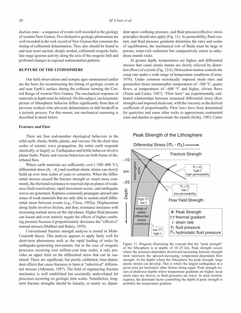
dent upon confi ning pressure, and fl uid pressure/effective stress principles should also apply (Fig. 11). As permeability, fl uid con-tent, and fl uid pressure gradients determine the rates and scales of equilibration, the mechanical role of fl uids must be large in porous, water-rich sediments but comparatively minor in anhy-drous mantle rocks.
At greater depth, temperatures are higher, and differential stresses that cause elastic strains are slowly relieved by distor-tion (fl ow) of crystals (Fig. 12A). Dislocation motion controls the creep rate under a wide range of temperature conditions (Carter, 1976). Under common tectonically imposed strain rates and greenschist facies metamorphic temperatures of ~300 °C, quartz fl ows; at temperatures of ~600 °C and higher, olivine fl ows (Tsenn and Carter, 1987). “Flow laws” are experimentally cali-brated relationships between measured differential stress (fl ow strength) and imposed strain rate, with the viscosity as the derived coeffi cient of proportionality. Flow laws have been determined for quartzites and some other rocks to approximate continental crust and dunites to approximate the mantle (Kirby, 1983; Carter
Figure 11. Diagram illustrating the concept that the “peak strength” of the lithosphere is at depths of 10–25 km. Peak strength occurs where the pressure-dependent downward-increasing fracture strength limit intersects the upward-increasing, temperature-dependent fl ow strength. At the depths where the lithosphere has peak strength, large elastic strains can develop. This is where the largest earthquakes in a given area are nucleated, other factors being equal. Peak strength oc-curs at shallower depths where temperature gradients are higher, local strain rates are slower, or fl uid pressures are lower. In most tectonic regimes, the dominant factor controlling the depth of peak strength is probably the temperature gradient.
Mechanics of Subducting Slab Breakoff by Collisional Delamination 21
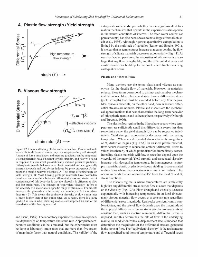
and Tsenn, 1987). The laboratory experiments show an exponen-tial dependence on temperature and strain rate. Appropriate tem-perature conditions can be simulated, but the experiments must be done at laboratory strain rates that are more than fi ve orders of magnitude faster than natural conditions. The validity of the
extrapolations depends upon whether the same grain-scale defor-mation mechanisms that operate in the experiments also operate in the natural conditions of interest. The trace water content (at ppm amounts) has also been shown to have large effects (Kohlst-edt et al., 1995). Although rigorous quantitative extrapolation is limited by the multitude of variables (Rutter and Brodie, 1991), it is clear that as temperatures increase at greater depths, the fl ow strength of silicate materials decreases exponentially (Fig. 11). At near-surface temperatures, the viscosities of silicate rocks are so large that any fl ow is negligible, and the differential stresses and elastic strains can build up to the point where fracture-causing earthquakes occur.
Plastic and Viscous Flow
Many workers use the terms plastic and viscous as syn-onyms for the ductile fl ow of materials. However, in materials science, these terms correspond to distinct end-member mechan-ical behaviors. Ideal plastic materials have a differential stress (yield strength) that must be exceeded before any fl ow begins. Ideal viscous materials, on the other hand, fl ow wherever differ-ential stresses are nonzero. Plastic and viscous are the mechani-cal approximations that best characterize the long-term behavior of lithospheric mantle and asthenosphere, respectively (Oxburgh and Turcotte, 1976).
The plastic fl ow regime in the lithosphere occurs where tem-peratures are suffi ciently small that differential stresses less than some fi nite value, the yield strength (σ
y), can be supported indef-
initely. Yield strength exponentially decreases with increasing temperature. Whenever differential stress attains the magnitude of σ
y, distortion begins (Fig. 12A). In an ideal plastic material,
fl ow occurs instantly to reduce the ambient differential stress to values less than σ
y, at which point distortion immediately ceases.
In reality, plastic materials will fl ow at rates that depend upon the viscosity of the material. Yield strength and associated viscosity increase with decreasing temperature. In homogeneous, isotro-pic materials, plastic or plastico-viscous yielding is concentrated in directions where the shear stress is at maximum values. This occurs in bands that are oriented at 45° from the local σ
1 and σ
3
stress directions.The viscous regime is where temperatures are suffi ciently
high that any differential stress causes fl ow at a rate that depends on the viscosity (Fig. 12B). Flow strength and viscosity decrease exponentially with increasing temperature. In an ideal (Newto-nian) viscous material, fl ow occurs at a constant rate regardless of differential stress magnitude. Real rocks are signifi cantly non-Newtonian, and the rate of fl ow depends upon the magnitude of the imposed differential stress or strain rate. In environments of constant load, such as inactive seamounts, differential stress is imposed, and this determines the rate of fl ow in the underlying mantle. In subduction zones, a displacement rate is imposed that determines the magnitudes of the differential stresses generated in the zone of fl ow. The “equivalent viscosity” is the resistance to fl ow at specifi ed conditions of temperature and differential stress
Figure 12. Factors affecting plastic and viscous fl ow. Plastic materials have a fi nite differential stress they can support—the yield strength. A range of force imbalances and pressure gradients can be supported. Viscous materials have a negligible yield strength, and fl ow will occur in response to even small gravitationally induced pressure gradients. Lithospheric mantle behaves as a plastic material and can generally transmit the push and pull forces induced by plate movement. Asthe-nospheric mantle behaves viscously. A: The effect of temperature on yield strength. B: Most fl owing geologic materials have power-law (nonlinear) relationships between differential stress and strain rate. A consequence of this behavior is that the viscosity is different at slow and fast strain rates. The concept of “equivalent viscosity” refers to the viscosity of a material at a specifi c range of strain rate. For silicate minerals, the power-law relationship is commonly a factor of about three (n = 3). This means the equivalent viscosity at slow strain rates is much higher than at fast strain rates. As a result, there is a large gradient in strain when shearing motions are imposed on one of the boundaries of the fl owing material.
22 M. Cloos et al.
or strain rate. In ideal homogeneous materials, viscous fl ow is evenly distributed throughout the deforming body. In a section of real rock, fl ow is concentrated in weak zones and along boundar-ies that move.
The Lithosphere: Brittle/Plastic Behavior
Oceanic lithosphere is best approximated as having an upper elastic/brittle and underlying elastic/plastic structure (Fig. 11). Most of the time, ambient differential stresses are less than the fracture strength near the surface or the fl ow strength at depth. Internal density differences due to composition and temperature are rarely suffi cient to cause movement, and heat fl ow through the lithosphere is primarily by conduction. In continental areas, thermal gradients are in the range of ~30 °C/km in the crust where the heat-producing elements are concentrated, and as low as 5 °C/km in the underlying lithospheric mantle. In oceanic lith-osphere, thermal gradients are systematically related to plate age. Near ocean ridges, thermal gradients are as high as 100 °C/km. Where oceanic lithosphere is ca. 80 Ma, thermal gradients are near 10 °C/km.
An important exception is the plutonic/volcanic arc envi-ronment where intruding magmas advect heat upwards and ther-mally weaken the wall rock. In long-lived subduction systems, a major zone of weakness typically exists along the line of the arc in the overriding plate.
Where tectonic movements generate differential stresses that exceed the local strength of the lithosphere, deformation can create variations in topography and crustal thickness. Once this occurs, gravity alone can generate suffi cient differential stresses that drive local movements and continue long after plate tecto-nism has ceased (extensional collapse) (Dewey et al., 1993). The rate of these gravity-driven movements slows progressively as erosion and sedimentation fl atten topography and deeper-seated “isostatic” adjustments occur.
In mantle materials, dislocation glide is the dominant defor-mation mechanism in the regime of plastic fl ow. This is a condi-tion where the fl ow of rock is limited by the ability of disloca-tions to migrate across olivine and pyroxene crystals. Because of the increase in temperature with depth, the yield strength of mantle materials decreases progressively downwards. The frac-ture strength and fl ow strength intersect, forming a band with “peak strength” typically at depths of 10–25 km in old oceanic lithosphere (Fig. 11). The yield strength in this depth range is suffi cient to transmit horizontally the typical differential stresses arising from the push and pull forces that drive plate motion.
The Asthenosphere: Viscous Response
The asthenosphere is where temperatures are suffi ciently high that rock fl ow by distortion of olivine and pyroxene readily occurs. Dislocation climb is the dominant grain-scale deforma-tion mechanism, a condition attained where dislocation move-ment is substantially aided by atomic diffusion. Flow in the
asthenosphere occurs wherever pressure gradients are not at equilibrium values. Where movements thin or thicken the over-lying lithospheric plate or where erosion and sedimentation cause variations in loading, fl ow occurs in the asthenosphere to accom-modate changes in the load of the overlying lithosphere and its cover of sediment.
The base of the lithosphere is a rheological boundary that is primarily temperature-controlled. The asthenosphere is the source of ocean ridge basaltic magmas that erupt at temperatures of 1100–1200 °C (Philpotts, 1990), indicating a minimum tempera-ture for the source region. Strong supporting observations for dif-fering mechanical behavior with depth come from mantle nodules in basalts from rift zones or ocean islands in mid-plate settings (Finnerty and Boyd, 1987; Nixon and Davies, 1987). Nodules with textures indicating annealing and long-term static conditions and a lithospheric source typically come from depths less than ~100 km (P < 30 kbar) and typically record temperatures less than 1100 °C. Nodules with sheared fabrics indicating recent fl ow and an astheno-spheric source are more common from greater depths and typically record temperatures ~1200–1400 °C.
The transition from lithospheric mantle with some strength to viscously fl owing asthenosphere should occur over a fairly narrow zone. The gradient in temperature downwards causes fl ow strength to decrease downwards. Laboratory experiments show that silicate minerals have differential stress-strain rate relationships that are signifi cantly nonlinear (Fig. 12B). For small differential stresses, the fl ow rate is slow and the effec-tive viscosity high. For larger differential stresses, the fl ow rate is faster and the effective viscosity lower. As a result, differen-tial shearing movements from normal plate motions are con-centrated into the hotter, basal part of the lithosphere. The base of the lithosphere should be thought of as a zone across which there is a large strain rate gradient anytime the lithosphere and asthenosphere are moving with respect to one another. Flow-law relationships indicate that the gradation from negligible fl ow (high viscosity) to signifi cant fl ow (low viscosity) under most plausible conditions of plate movement should occur across an interval of ~100 °C. This would correspond to a thickness inter-val of ~10 km, assuming a conductive thermal gradient of 10 °C/km in the lower lithosphere.
There is a well-established phenomenon that bears on the thickness of the shear zone at the bottom of the lithosphere. Geophysicists have long correlated the top of the asthenosphere with the top of the “low-velocity zone.” Beneath most oceanic and some continental areas, the low-velocity zone has a fairly abrupt top at ~100 km depth and gradational bottom at ~250 km depth (Anderson, 1989, p. 51). The low-velocity zone, named for the slower travel times and attenuation of seismic waves, is thought to be caused by the presence of a small amount of melt, indicating temperature conditions just below the solidus. Less than 1% melt can account for these geophysical observations (O’Connell and Budiansky, 1977). Although the magnitude of the mechanical effect of partial melting is not well calibrated, it is clear that the bulk viscosity is lower if any melt is present and
Mechanics of Subducting Slab Breakoff by Collisional Delamination 23
progressively decreases as the amount of partial melt increases (Kohlstedt and Zimmerman, 1996). If, as it appears, the base of the lithosphere is where the change from near-solidus to slightly suprasolidus conditions occurs, the base of the lithosphere can be symbolized as an isotherm that approximates a zone perhaps only a few kilometers thick.
Since the advent of plate tectonics, most geophysicists believe that the viscosity in the asthenosphere is suffi ciently low that steady convective fl ow occurs in this part of the mantle. The near chemical uniformity of ocean ridge basalts indicates that global-scale homogenization of the asthenosphere occurs on the 200–400 m.y. time scale. This directly indicates that the asthenosphere is well mixed, perhaps even at the kilome-ter scale. This strongly suggests that buoyancy forces that arise from density differences due to temperature and compositional gradients readily drive internal circulation. Consequently, heat fl ow in the asthenosphere is primarily by convection, and ther-mal gradients are nearly adiabatic (~0.5 °C/km).
There is a chemical matter of special importance to issues of magmagenesis. Most partial melt in the asthenosphere should be buoyant and tend to infi ltrate upwards, or pool and then intrude as dikes, into the overlying lithospheric mantle. Small amounts of magma have small heat contents. Thus, when rising into lithospheric mantle, whether by infi ltration or as small dikes, they would rapidly cool and solidify. This process can produce dramatic chemical modifi cation of the lower litho-spheric mantle over time. Lithospheric mantle becomes “fertil-ized” (metasomatized) with K, S, Cl, Ti, Fe, P, LREEs (light rare earth elements), and other elements that are “incompatible” with the olivine, pyroxene, and garnet in the asthenosphere and hence are concentrated in small-degree partial melts that intrude upward (Roden and Murthy, 1985; McKenzie, 1989; Menzies, 1990). These elements are “stored” in the lithospheric mantle within phlogopite, amphibole, rutile, ilmenite, apatite, various sulfi des, and exotic minerals. Consequently, magmas that are derived from, or pass through, metasomatized lithosphere will generally have distinctive trace element and isotopic composi-tions. Thus, a component of melt from the lithospheric mantle is geochemically distinctive and detectable in magmas from continental rift zones (Hawkesworth et al., 1990; Gibson et al., 1992). As will be discussed, signifi cant quantities of magma should be derived from a lithospheric mantle source in areas of collisional delamination.
PEAK STRENGTH IN THE CRUST AND MANTLE
The strength profi le of lithosphere requires further eval-uation because there are dramatic mechanical differences between areas capped by continental versus oceanic crust. Where temperatures are low, the strength of rocks that com-pose the crystalline basement is high because friction resists internal distortion. The differential stress required for slip on preexisting fractures or other weak anisotropies, or the forma-tion of entirely new fractures, increases linearly with depth.
Where fl uid pressures are elevated because of prograde meta-morphic dehydration or distributed partial melting, the effect of higher confi ning pressures is negated. At depth, high enough temperatures are attained so that plastic fl ow (distributed strain) occurs rather than fracture. As temperatures increase, fl ow strength exponentially decreases. The largest differen-tial stress, or “peak strength,” in the earth must occur at the crossover between downward-increasing fracture strength and upward-increasing plastic fl ow strength (Fig. 11) (Brace and Kohlstedt, 1980; Kohlstedt et al., 1995). For a given area, the largest differential stresses, consequent elastic strains, and thus the largest earthquakes should develop near the depth of the strength crossover. Strain rate effects on fl ow strength are qualitatively similar, but opposite, to those of temperature. High fl uid pressure conditions, either aqueous or magmatic, enable fracturing at great depths (Fig. 11).
Strong supporting evidence for the concept of a zone of peak strength in the lithosphere comes from the observation that most large (M > 7) earthquakes originate at depths of 10–25 km (Sibson, 1989; Scholz, 1990). At shallow depths, rocks are too weak to support the buildup of large elastic strains. In areas of high thermal gradient, the deepest earthquakes are shallower and vice versa. The extreme case of lower thermal gradient occurs in subduction zones, where most large earth-quakes are thrust-type and originate at depths of 25–60 km. The extreme case of higher thermal gradients occurs near ocean ridges, where the largest earthquakes are normal-type and originate at depths less than 10 km.
The effects of temperature gradient, strain rate, and fl uid pressure on peak strength in oceanic and continental litho-sphere are schematically summarized on Figure 13. In areas with normal thermal gradients, peak strength lies within the upper mantle for old oceanic lithosphere, but within the crust for all but the thinnest continental crust. The crust under the continents is always ~30 km thick at the locations near the shoreline and typically ~40 km thick in the interior (Mooney et al., 1998). The geophysical properties of crust under the shelves is intermediate to that of typical continental and oceanic ter-ranes, and this region is commonly referred to as underlain by “transitional crust” (Bond and Kominz, 1988). Transitional crust forms during continental rifting when normal faulting, erosion of uplifted blocks, and ductile stretching thin the crust, and mafi c intrusions increase its density.
The key conclusion is that the strength profi le of “nor-mal” 30+ km thick continental lithosphere is distinctly differ-ent from that of oceanic lithosphere (Fig. 13). The mechani-cal implication is that normal continental crust is only weakly coupled to the underlying lithospheric mantle. In the interior of continents, the brittle middle part of the crust is underlain by a plastic zone that overlays the viscously behaving lower crust.
It is not necessary for the lower crust to be uniform in composition to behave viscously. Only parts of it must contain signifi cant quantities of quartz (>10%?). It is highly likely that in some areas, the lower crust is entirely made of granitic rock,
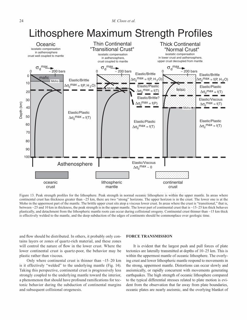
24 M. Cloos et al.
and fl ow should be distributed. In others, it probably only con-tains layers or zones of quartz-rich material, and these zones will control the nature of fl ow in the lower crust. Where the lower continental crust is quartz-poor, the behavior may be plastic rather than viscous.
Only where continental crust is thinner than ~15–20 km is it effectively “welded” to the underlying mantle (Fig. 14). Taking this perspective, continental crust is progressively less strongly coupled to the underlying mantle toward the interior, a phenomenon that should have profound ramifi cations for tec-tonic behavior during the subduction of continental margins and subsequent collisional orogenesis.
FORCE TRANSMISSION
It is evident that the largest push and pull forces of plate tectonics are laterally transmitted at depths of 10–25 km. This is within the uppermost mantle of oceanic lithosphere. The overly-ing crust and lower lithospheric mantle respond to movements in the strong, uppermost mantle. Distortions can occur slowly and aseismically, or rapidly concurrent with movements generating earthquakes. The high strength of oceanic lithosphere compared to the typical differential stresses related to plate motion is evi-dent from the observation that far away from plate boundaries, oceanic plates are nearly aseismic, and the overlying blanket of
Figure 13. Peak strength profi les for the lithosphere. Peak strength in normal oceanic lithosphere is within the upper mantle. In areas where continental crust has thickness greater than ~25 km, there are two “strong” horizons. The upper horizon is in the crust. The lower one is at the Moho in the uppermost part of the mantle. The brittle upper crust sits atop a viscous lower crust. In areas where the crust is “transitional,” that is, between ~25 and 10 km in thickness, the peak strength is in the upper mantle. The lower part of continental crust that is ~15–25 km thick behaves plastically, and detachment from the lithospheric mantle roots can occur during collisional orogeny. Continental crust thinner than ~15 km thick is effectively welded to the mantle, and the deep subduction of the edges of continents should be commonplace over geologic time.
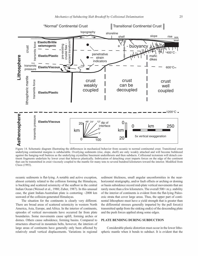
Mechanics of Subducting Slab Breakoff by Collisional Delamination 25
oceanic sediments is fl at-lying. A notable and active exception, almost certainly related to the collision forming the Himalayas, is buckling and scattered seismicity of the seafl oor in the central Indian Ocean (Weissel et al., 1980; Zuber, 1987). In this unusual case, the giant Indian-Australian plate is contorting ~2000 km seaward of the collision-generated Himalayas.
The situation for the continents is clearly very different. There are broad areas of scattered seismicity in western North America, Asia, Europe, and Africa. In the interior of continents, episodes of vertical movements have occurred far from plate boundaries. Some movements cause uplift, forming arches or domes. Others cause subsidence, forming basins. Compared to structures observed in mountain belts, however, the interiors of large areas of continents have generally only been affected by relatively small vertical displacements. Variations in regional
sediment thickness, small angular unconformities in the near-horizontal stratigraphy, and/or fault offsets or arching or doming or basin subsidence record mid-plate vertical movements that are rarely more than a few kilometers. The overall 500+ m.y. stability of the interior of continents is evident from the fl at-lying Paleo-zoic strata that cover large areas. Thus, the upper part of conti-nental lithosphere must have a yield strength that is greater than the differential stresses generally imparted by the pull force(s) transmitted updip from the sinking end(s) of the descending plate and the push forces applied along some edges.
PLATE BENDING DURING SUBDUCTION
Considerable plastic distortion must occur in the lower litho-spheric mantle when it bends to subduct. It is evident that the
Figure 14. Schematic diagram illustrating the differences in mechanical behavior from oceanic to normal continental crust. Transitional crust underlying continental margins is subductable. Overlying sediments (rise, slope, shelf) are only weakly attached and will become bulldozed against the hanging-wall buttress as the underlying crystalline basement underthrusts and then subducts. Collisional tectonism will detach con-tinent fragments underlain by lower crust that behaves plastically. Imbrication of detaching crust imparts forces on the edge of the continent that can be transmitted in crust viscously coupled to the mantle for many tens to several hundred kilometers toward the interior. Modifi ed from Cloos (1993).
26 M. Cloos et al.
bending and unbending of oceanic lithosphere occurs steadily for many tens or even 100+ m.y. The lower part of oceanic litho-sphere must fi rst contract as the hinge forms and then extend as it unbends to straighten and continue descent into the mantle. Where the bending is tight because the subducting plate dip is steep, the ocean crust and uppermost mantle fracture. Normal faults with scarps up to a few hundred meters high are common in the seafl oor between the base of the trench slope and the top of the outer rise. Their formation is concurrent with normal-type, bending-induced earthquakes detected near the outer rise (Isacks et al., 1968). Although the near-surface rupture of descending oceanic lithosphere is commonplace, it has no obvious direct long-term effect on the overall subduction process. This indicates that faulted oceanic crust remains welded to, and subducts with, the underlying upper mantle.
As evident from the Himalayas and the European Alps, the situation is very different where continent-capped lithosphere enters a subduction zone. Where 30+ km thick continental crust is involved, there are two distinct horizons of peak strength: an upper zone of peak strength in the middle of the crystalline crust and a lower zone in the uppermost mantle (Fig. 13). These hori-zons of strength are separated by the lower crust that has a fl ow strength that should typically decrease downwards as tempera-ture increases, but compositional factors may dominate. Where continental crust is thinner than ~15–20 km, that is, beneath the continental shelf and slope, the crust in contact with lithospheric mantle responds plastically with a yield strength that generally should increase as crust thickness decreases. This mechanical picture (Fig. 14) has considerable tectonic implications for crustal response as a continental margin enters a subduction zone.
Crust underlying the continental slopes and outermost shelf areas is effectively welded to the lithospheric mantle, and the peak strength is in the upper mantle. The faster the speed of sub-duction, the deeper such crust can be subducted before heating weakens the attachment to the underlying mantle. Where con-tinental crust is of 30+ km thickness, a zone, 10 km or so thick, in the lower crust is typically warm enough to fl ow viscously. Crystalline middle crust with signifi cant fracture and plastic fl ow strength, and any overlying sediments with negligible strength, are effectively fl oating on the lower crust. Where subduction to mantle depths is attempted, normal-thickness continental crust must detach from its mantle underpinning, because the buoyancy forces resisting the subduction of continental lithosphere are as large as those driving oceanic lithosphere downwards (Cloos, 1993). This factor alone can explain the long-term preservation of old continental crust.
However, continental detachment should typically begin well before 30+ km thick crust starts to bend downwards to sub-duct. Crustal detachment should initiate where positively buoy-ant lithosphere begins to turn downwards to move to mantle depths. This is where the crust is 15–20 km thick and transitional in nature. The lower part has a fi nite yield strength and thus responds plastically (see Fig. 13). By the time continental crust that is weakly attached to the underlying mantle is forced to turn downwards to subduct, crustal buoyancy generates substantial resistive forces that are transmitted updip and laterally toward the interior of the continent. These are the collisional forces that cause uplift, crustal thickening, and other tectonic move-ments many tens to hundreds of kilometers landward of a trench. All of this reasoning leads to the expectation that the effects of mechanical layering during subduction zone jamming—the pro-cess of collisional delamination—combine to create a predict-able sequence of events, well recorded in the surface geology of New Guinea.
BUOYANCY OF THE LITHOSPHERE
Nearly all subduction (except where the oceanic lithosphere is younger than ca. 10 Ma) is driven by the inherent negative buoyancy of oceanic lithosphere compared to the underlying asthenosphere. But before proceeding, the density distribution of lithosphere and the location of the negative buoyancy requires some discussion. The lithosphere is strong, for it is the cooler outer boundary layer of the mantle. As the temperature of the mantle at the base of the lithosphere is almost the same as that at the top of the asthenosphere, the density is nearly the same. Because the variation in compressibility as a function of temper-ature is comparatively small (Anderson, 1989, p. 86), the density at depth is almost entirely a result of temperature difference. The equivalent 1 bar density profi le for the mantle is shown in Figure 15. Most of the negative buoyancy of an oceanic plate is gener-ated in the cooler, upper 30 km of lithospheric mantle.
The sinking plate is most dense where it is also the strongest. Consequently, peak strength corresponds to where the magnitude of the updip pull force from plate sinking is also a maximum. We believe this is the factor controlling the response of the descend-ing plate during collisional delamination.
In Chapter 3, the geological observations of Chapter 1 will be integrated with the mechanical principles discussed in Chapter 2 to generate a series of scaled, lithospheric-scale cross sections of the collisional delamination event that created the Central Range of New Guinea.

Figure 15. A: Temperature profi le of the lithosphere. “Potential temperature” is the equivalent temperature at surface pressure “corrected” for the adiabatic temperature increase with depth that results from compression. The lithosphere is a conductive thermal boundary layer between the surface and the asthenosphere that convects freely and maintains a near-adiabatic temperature gradient. B: Bulk density profi le of the lithosphere. Absolute densities are uncertain because exact rock composition is uncertain, but for oceanic lithosphere and asthenosphere, the relative density contrasts are well constrained. The high density of the uppermost mantle (up to 3.39 g/cm3) is due to lower temperature and resultant thermal contraction. The lower part of lithospheric mantle is nearly at the temperature of the asthenosphere and thus has nearly the same density. Den-sity increase due to compression is not included, for it is a comparatively minor second-order phenomenon that affects hot and cold mantle to a similar magnitude. From this fi gure it is apparent that the negative buoyancy of the lithosphere resides in the upper 20 km or so of the mantle. Compared to the density contrasts that drive subduction, the extreme low density of continental crust will resist subduction proportional to the amount of mass involved. Nonetheless, the deep subduction of the thinned edges of continents (transitional crust) occurs shortly before col-lisional orogenesis begins. During normal subduction, the downward shearing forces imparted by the sinking of the oceanic lithosphere drags a thin layer of sediment to the depths of arc magmagenesis. Parameters are consistent with those in Cloos (1993).

29
COLLISIONAL DELAMINATION—SCALED CROSS SECTIONS
Lithospheric-scale cross sections of the Central Range orogeny were drawn to refl ect the events recorded in the geol-ogy of New Guinea (discussed in Chapter 1 and summarized in Table 1), the consideration of the mechanical layering of con-tinental lithosphere, and the physical constraints on collisional orogenesis in Cloos (1993). In this case, the collision resulted from north-directed subduction of ocean-crust-capped litho-sphere, which changed to transitional Australian-crust-capped lithosphere. The essential geodynamic requirement is that steady subduction occurs as long as the descending plate has a bulk den-sity greater than the underlying asthenosphere (negatively buoy-ant). When the incoming plate has a bulk density less than the underlying asthenosphere (positively buoyant), the subduction zone eventually jams. Normal oceanic lithosphere, oceanic litho-sphere capped by short-lived or young island arcs (<~20 m.y.), and continental margins underlain by thin crust are inherently subductable because the bulk density of the crystalline crust and lithospheric mantle is greater than that of the underlying asthe-nospheric mantle.
An important concept is that sedimentary rocks are not welded to the crystalline basement. Sediments simply ride on the top of the plate and thus do not add to lithospheric buoyancy. Of course, loading by sediment deposition or unloading by erosion do cause vertical isostatic adjustments.
At current shorelines, continental crust typically has a thick-ness of ~30 km. With this crustal thickness, the lithosphere has a positive buoyancy that is nearly the same magnitude as the negative buoyancy that drives steady subduction of 50+ Ma oceanic lithosphere. All but the youngest oceanic lithosphere is inherently subductable. On passive margins, neutral lithospheric buoyancy occurs somewhere beneath the continental shelf. Shelf width varies from a few tens of kilometers to many hundreds of kilometers, as off southeastern South America (Falklands area) and northern Australia (the New Guinea region).
Underthrusting occurs before “true” subduction that involves the downward movement of crustal materials to mantle depths. Sediment offscraping occurs at the front of the trench slope. Material that moves under the hanging-wall block is simply underthrusting until it reaches the point where true subduction begins. In the zone of underthrusting, sediments are bulldozed, and the defl ection of the descending plate is simply an isostatic
Geological Society of AmericaSpecial Paper 400
2005
Chapter 3
Palinspastic Reconstruction of Collisional Delamination in New Guinea
adjustment to the load. The base of the trench slope marks the seaward extent of deformation of the hanging-wall block. Where not buried by sediment, an outer rise, commonly 100–200 m high, is located ~100 km farther seaward. The outer rise marks the sea-ward extent of deformation of the descending plate. Collisional orogenesis only begins when positively buoyant lithosphere is forced to bend downwards and begin true subduction. In the case of New Guinea, the component of head-on convergence was ~5 cm/yr, and about fi ve million years elapsed between when con-tinental-crust-capped lithosphere began to underthrust and when crystalline basement began to be uprooted because of collisional orogenesis.
Scaled cross sections are presented to take into account all known timing constraints for the development of the orogeny that formed the western Central Range of New Guinea. As the ages of most events are known within time spans of 2 m.y., our cross sections are drawn at 2 m.y. increments.
The sections are drawn using relative Australian-Pacifi c plate motions that indicate convergence at a speed of ~50 km/m.y. prior to 5 Ma (see Scotese et al., 1988). The cross sections are drawn from the Central Range foreland to beyond the New Guinea Trench, and the events generate the geologic relations depicted along section B–B′ on Figure 9. Reference points for sequential comparison of position are the relict New Guinea Trench for the overriding plate and the Timika airport for the subducting Australian plate.
Several concepts need refi nement to add focus on funda-mental tectonic processes. The use of the terms “accretionary prism” for steady-state subduction zones and “collisional moun-tain belt” for cases of attempted continental subduction are well established in the literature, but the distinction of where steady subduction ends and collision begins is not.
Sediments deposited upon oceanic basement (abyssal plain and rise deposits) are deformed at the base of the trench slope. During steady convergence, a layer of sediment, up to 500 m or so thick, and in some cases the entire incoming sediment pile, subducts to the depths of arc magmagenesis. Once continental shelf and slope deposits enter the realm of subduction-driven deformation, the bulk of the pile is simply offscraped into a steadily growing mass. Offscraping and underplating occur with no change in the speed of convergence (see discussion in Cloos and Shreve, 1988a, 1988b). Once thick slope and shelf deposits are involved, the offscraping deformation is far from a steady-state condition because an ever thickening wedge of sediment
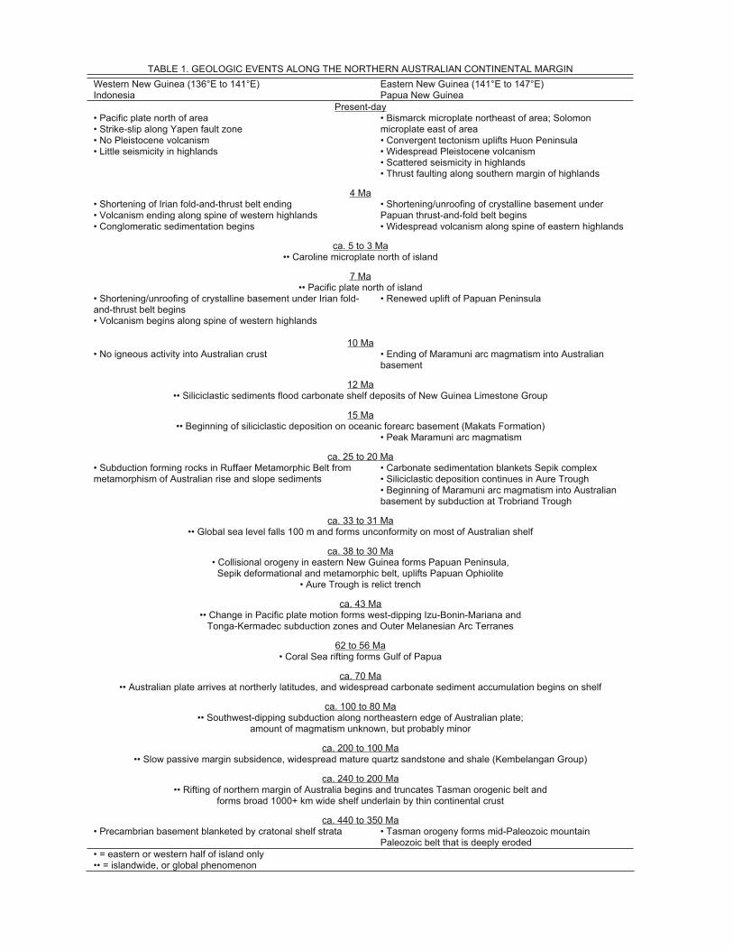
TABLE 1. GEOLOGIC EVENTS ALONG THE NORTHERN AUSTRALIAN CONTINENTAL MARGIN
Western New Guinea (136°E to 141°E) Eastern New Guinea (141°E to 147°E) Indonesia Papua New Guinea
Present-day• Pacific plate north of area • Strike-slip along Yapen fault zone
• Bismarck microplate northeast of area; Solomon microplate east of area
• No Pleistocene volcanism • Convergent tectonism uplifts Huon Peninsula • Little seismicity in highlands • Widespread Pleistocene volcanism • Scattered seismicity in highlands • Thrust faulting along southern margin of highlands
4 Ma• Shortening of Irian fold-and-thrust belt ending • Volcanism ending along spine of western highlands
• Shortening/unroofing of crystalline basement under Papuan thrust-and-fold belt begins
• Conglomeratic sedimentation begins • Widespread volcanism along spine of eastern highlands
ca. 5 to 3 Ma•• Caroline microplate north of island
7 Ma•• Pacific plate north of island
• Shortening/unroofing of crystalline basement under Irian fold-and-thrust belt begins
• Renewed uplift of Papuan Peninsula
• Volcanism begins along spine of western highlands
10 Ma• No igneous activity into Australian crust • Ending of Maramuni arc magmatism into Australian
basement
12 Ma•• Siliciclastic sediments flood carbonate shelf deposits of New Guinea Limestone Group
15 Ma•• Beginning of siliciclastic deposition on oceanic forearc basement (Makats Formation)
• Peak Maramuni arc magmatism
ca. 25 to 20 Ma• Carbonate sedimentation blankets Sepik complex • Subduction forming rocks in Ruffaer Metamorphic Belt from
metamorphism of Australian rise and slope sediments • Siliciclastic deposition continues in Aure Trough • Beginning of Maramuni arc magmatism into Australian
basement by subduction at Trobriand Trough
ca. 33 to 31 Ma•• Global sea level falls 100 m and forms unconformity on most of Australian shelf
ca. 38 to 30 Ma• Collisional orogeny in eastern New Guinea forms Papuan Peninsula,
Sepik deformational and metamorphic belt, uplifts Papuan Ophiolite • Aure Trough is relict trench
ca. 43 Ma•• Change in Pacific plate motion forms west-dipping Izu-Bonin-Mariana and
Tonga-Kermadec subduction zones and Outer Melanesian Arc Terranes
62 to 56 Ma• Coral Sea rifting forms Gulf of Papua
ca. 70 Ma•• Australian plate arrives at northerly latitudes, and widespread carbonate sediment accumulation begins on shelf
ca. 100 to 80 Ma•• Southwest-dipping subduction along northeastern edge of Australian plate;
amount of magmatism unknown, but probably minor
ca. 200 to 100 Ma•• Slow passive margin subsidence, widespread mature quartz sandstone and shale (Kembelangan Group)
ca. 240 to 200 Ma•• Rifting of northern margin of Australia begins and truncates Tasman orogenic belt and
forms broad 1000+ km wide shelf underlain by thin continental crust
ca. 440 to 350 Ma• Precambrian basement blanketed by cratonal shelf strata • Tasman orogeny forms mid-Paleozoic mountain
Paleozoic belt that is deeply eroded • = eastern or western half of island only •• = islandwide, or global phenomenon
Palinspastic Reconstruction of Collisional Delamination in New Guinea 31
is bulldozed. To differentiate this phase of tectonism, the term “precollision complex” is used in this report. The progressively greater infl ux of passive margin strata (larger sediment supply as defi ned by Shreve and Cloos, 1986) would quickly cause a precollision complex to become emergent as the pile grows in thickness and width.
“Orogeny” is used in the classical sense as a term to describe the growth of subaerial mountains, or in other words, a tec-tonized landmass that will be subjected to erosion. In the case of the present-day island of New Guinea, the precollision com-plex was entirely submarine until small islands emerged at ca. 15 Ma. Emergent uplifts of passive margin strata with a lateral extent comparable to the present island started to shed large vol-umes of siliciclastic materials at ca. 12 Ma. This is considered the beginning of the Central Range orogeny proper. All of this deformation is “thin-skinned” during the steady underthrusting that predates the collisional jamming, at which time it becomes “thick-skinned.” The Australian crystalline basement underlying the western Central Range did not become involved in the defor-mation until ca. 8 Ma. This event marks the beginning of crustal
decapitation and other mechanical adjustments due to delamina-tion of the subducting lithosphere. From this perspective, it is evident that a transient phase of thin-skinned deformation dur-ing steady subduction predates thick-skinned deformation during collisional orogenesis.
25 Ma: Intraoceanic Subduction
Jurassic oceanic crust that formed after Triassic rifting of the northern edge of the Australian plate was subducted beneath a south-facing intraoceanic subduction zone (Fig. 16A). This phase of convergence in the western Pacifi c started when north-ward subduction began beneath the Outer Melanesian arc, the product of at least two phases of arc magmatism since the Eocene (Coleman and Packham, 1976; Kroenke, 1984; Mil-som, 1985; Packham, 1996). This plate reorganization is almost certainly due to the jamming of the Outer Melanesian subduc-tion zone by the Ontong Java Plateau, by ca. 25 Ma (Kroenke, 1984; Wells, 1989). The New Guinea Trench (NGT in Fig. 16A) and the magmatic complex that dates between 35 and 30 Ma
Figure 16. A: Lithospheric-scale cross section at 25 Ma. The Outer Melanesian Arc Terrane contains an old arc complex formed during south-dipping subduction at the New Guinea Trench from ca. 30 Ma, when reversal occurred and a new arc began to form by north-dipping subduction. Sediment derived from the Australian continent is deforming, recrystallizing, and accreting to the base of the forearc block, the Irian Ophiolite Belt, forming the phyllitic rocks now exposed in the Ruffaer Metamorphic Belt. The Arafura Sea and southern New Guinea are underlain by a broad, 1000 km wide zone of transitional continental crust that was stretched during Triassic rifting. Crust thickness and density profi les are illustrated along with the position of neutral lithospheric buoyancy (see Cloos, 1993). AUS—Australian plate, PAC—Pacifi c plate. (Figure 16 continues on following pages.)
32 M. Cloos et al.
at Dabera in the Irian Ophiolite Belt (Fig. 9) are relicts of the older southwest-dipping subduction system. The initial forearc block (now the uplifted Irian Ophiolite) and associated trench were probably similar to the modern Mariana Trench (Bloomer, 1983) except for the fact that the hanging-wall block contained signifi cant residual heat when subduction began because the arc was just extinguished.
Subduction reversal occurred at ca. 30 Ma. Soon after, conti-nentally derived detritus that entered the trench were subducted. The deeply accreted materials are now exposed as the Ruffaer Metamorphic Belt. Peak temperatures of ~350 °C were attained between ca. 28 and 20 Ma (Weiland, 1999). The petrology of the slates and phyllites indicate high-pressure greenschist facies conditions with recrystallization at depths of 15–25 km (Warren, 1995). The more phyllitic rocks are nearer the Irian Ophiolite Belt (position A in Fig. 16A), and the cooling arc complex in the hanging-wall block was a heat source causing metamorphism of the underplated materials.
Whether the metamorphosed sediments are Jurassic to Oligocene distal rise strata or distal Oligocene turbidites fun-neled far northwards along the trench is unclear. No distinctive stratigraphic horizons have been found, hindering recognition of any larger pattern of faulting and folding. Deformation in the
phyllitic part of the metamorphic belt is best characterized as penetratively distributed, as would be expected if the protoliths were poorly lithifi ed, Oligocene trench axis deposits.
15 Ma: Emergence of Isolated Islands
Between 25 and 15 Ma, 500 km of oceanic lithosphere was subducted beneath the Outer Melanesian Arc Terrane. As the Australian continent approached, a progressively greater thick-ness of abyssal plain and rise strata entered the subduction zone. By 15 Ma, small islands had emerged because the accretionary complex in front of the forearc block was 20 km or so thick (Fig. 16B). It is most likely that emergence of small islands resulted from the bulldozing of outer slope deposits of Jurassic to early Miocene age.
The evidence for subaerial exposure of the top of the precol-lision complex comes from the deposition of the siliciclastic-rich Makats Formation (Fig. 16B) in the eastern North Coast Basin. The basal Makats deposits are early Middle Miocene, 16–14 Ma. By ca. 15 Ma, small islands along the spine of a rising forearc high at the crest of a large accretionary complex were shedding debris northwards onto the forearc block. This material was uplifted and is now exposed in the Mamberamo region in the
50 km/m.y.
100 km
Negativebuoyancy
Positivebuoyancy
Timika
15 Ma : Emergence of Isolated Islands on Forearc High South North
+ -
shelf slope
Forearc
accretionary complex of
Mesozoic and Cenozoicrise/slope sediments
NCB
NCB = North Coast BasinNGT = New Guinea Trench
Makats Formationin forearc basin
NGT
thermally thinned
lithosphereunder arc
forearc blockcooled; RuffaerMetamorphics
underIrian Ophiolite
Figure 16 (continued). B: Lithospheric-scale cross section at 15 Ma. Approximately 500 km of convergence has occurred since 25 Ma. The new volcanic arc is well established, and the underlying lithosphere is thinner from the upward advection of heat in rising magma. Subduction of cold oceanic lithosphere has caused substantial cooling of the base of the forearc block, the Irian Ophiolite, and metamorphic rocks are no longer forming at the present depths of erosion into the Ruffaer Metamorphic Belt. Continental crust is shown about to underthrust, and rise strata from Jurassic to Miocene age have been bulldozed, forming a thick precollision complex that is locally emergent and subject to erosion. Siliciclastic detritus is shed northwards from isolated bathymetric highs to accumulate as the Makats Formation on top of the oceanic forearc block. The trench axis depression is a barrier to the southward transport of sediment onto the shelf.
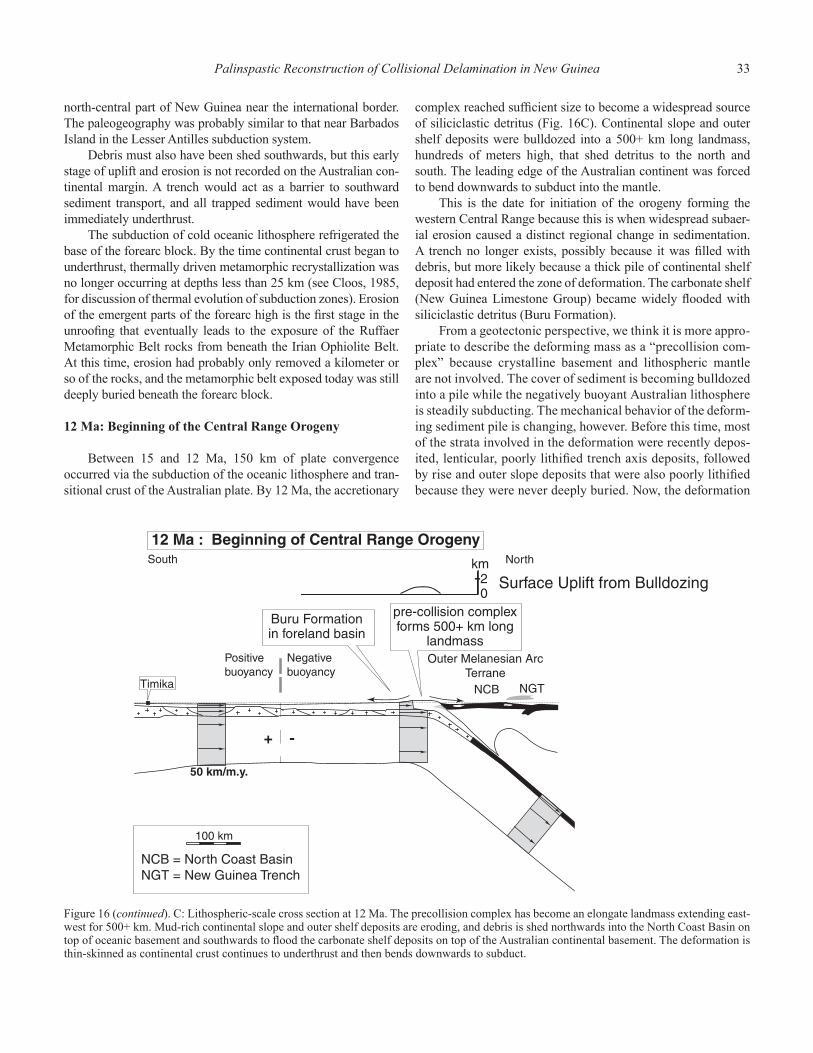
Palinspastic Reconstruction of Collisional Delamination in New Guinea 33
north-central part of New Guinea near the international border. The paleogeography was probably similar to that near Barbados Island in the Lesser Antilles subduction system.
Debris must also have been shed southwards, but this early stage of uplift and erosion is not recorded on the Australian con-tinental margin. A trench would act as a barrier to southward sediment transport, and all trapped sediment would have been immediately underthrust.
The subduction of cold oceanic lithosphere refrigerated the base of the forearc block. By the time continental crust began to underthrust, thermally driven metamorphic recrystallization was no longer occurring at depths less than 25 km (see Cloos, 1985, for discussion of thermal evolution of subduction zones). Erosion of the emergent parts of the forearc high is the fi rst stage in the unroofi ng that eventually leads to the exposure of the Ruffaer Metamorphic Belt rocks from beneath the Irian Ophiolite Belt. At this time, erosion had probably only removed a kilometer or so of the rocks, and the metamorphic belt exposed today was still deeply buried beneath the forearc block.
12 Ma: Beginning of the Central Range Orogeny
Between 15 and 12 Ma, 150 km of plate convergence occurred via the subduction of the oceanic lithosphere and tran-sitional crust of the Australian plate. By 12 Ma, the accretionary
complex reached suffi cient size to become a widespread source of siliciclastic detritus (Fig. 16C). Continental slope and outer shelf deposits were bulldozed into a 500+ km long landmass, hundreds of meters high, that shed detritus to the north and south. The leading edge of the Australian continent was forced to bend downwards to subduct into the mantle.
This is the date for initiation of the orogeny forming the western Central Range because this is when widespread subaer-ial erosion caused a distinct regional change in sedimentation. A trench no longer exists, possibly because it was fi lled with debris, but more likely because a thick pile of continental shelf deposit had entered the zone of deformation. The carbonate shelf (New Guinea Limestone Group) became widely fl ooded with siliciclastic detritus (Buru Formation).
From a geotectonic perspective, we think it is more appro-priate to describe the deforming mass as a “precollision com-plex” because crystalline basement and lithospheric mantle are not involved. The cover of sediment is becoming bulldozed into a pile while the negatively buoyant Australian lithosphere is steadily subducting. The mechanical behavior of the deform-ing sediment pile is changing, however. Before this time, most of the strata involved in the deformation were recently depos-ited, lenticular, poorly lithifi ed trench axis deposits, followed by rise and outer slope deposits that were also poorly lithifi ed because they were never deeply buried. Now, the deformation
Figure 16 (continued). C: Lithospheric-scale cross section at 12 Ma. The precollision complex has become an elongate landmass extending east-west for 500+ km. Mud-rich continental slope and outer shelf deposits are eroding, and debris is shed northwards into the North Coast Basin on top of oceanic basement and southwards to fl ood the carbonate shelf deposits on top of the Australian continental basement. The deformation is thin-skinned as continental crust continues to underthrust and then bends downwards to subduct.
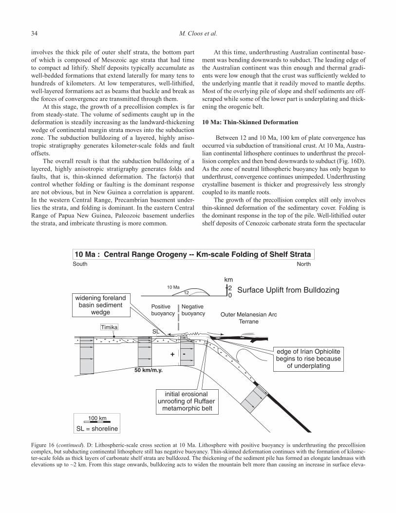
34 M. Cloos et al.
involves the thick pile of outer shelf strata, the bottom part of which is composed of Mesozoic age strata that had time to compact ad lithify. Shelf deposits typically accumulate as well-bedded formations that extend laterally for many tens to hundreds of kilometers. At low temperatures, well-lithifi ed, well-layered formations act as beams that buckle and break as the forces of convergence are transmitted through them.
At this stage, the growth of a precollision complex is far from steady-state. The volume of sediments caught up in the deformation is steadily increasing as the landward-thickening wedge of continental margin strata moves into the subduction zone. The subduction bulldozing of a layered, highly aniso-tropic stratigraphy generates kilometer-scale folds and fault offsets.
The overall result is that the subduction bulldozing of a layered, highly anisotropic stratigraphy generates folds and faults, that is, thin-skinned deformation. The factor(s) that control whether folding or faulting is the dominant response are not obvious, but in New Guinea a correlation is apparent. In the western Central Range, Precambrian basement under-lies the strata, and folding is dominant. In the eastern Central Range of Papua New Guinea, Paleozoic basement underlies the strata, and imbricate thrusting is more common.
At this time, underthrusting Australian continental base-ment was bending downwards to subduct. The leading edge of the Australian continent was thin enough and thermal gradi-ents were low enough that the crust was suffi ciently welded to the underlying mantle that it readily moved to mantle depths. Most of the overlying pile of slope and shelf sediments are off-scraped while some of the lower part is underplating and thick-ening the orogenic belt.
10 Ma: Thin-Skinned Deformation
Between 12 and 10 Ma, 100 km of plate convergence has occurred via subduction of transitional crust. At 10 Ma, Austra-lian continental lithosphere continues to underthrust the precol-lision complex and then bend downwards to subduct (Fig. 16D). As the zone of neutral lithospheric buoyancy has only begun to underthrust, convergence continues unimpeded. Underthrusting crystalline basement is thicker and progressively less strongly coupled to its mantle roots.
The growth of the precollision complex still only involves thin-skinned deformation of the sedimentary cover. Folding is the dominant response in the top of the pile. Well-lithifi ed outer shelf deposits of Cenozoic carbonate strata form the spectacular
Figure 16 (continued). D: Lithospheric-scale cross section at 10 Ma. Lithosphere with positive buoyancy is underthrusting the precollision complex, but subducting continental lithosphere still has negative buoyancy. Thin-skinned deformation continues with the formation of kilome-ter-scale folds as thick layers of carbonate shelf strata are bulldozed. The thickening of the sediment pile has formed an elongate landmass with elevations up to ~2 km. From this stage onwards, bulldozing acts to widen the mountain belt more than causing an increase in surface eleva-
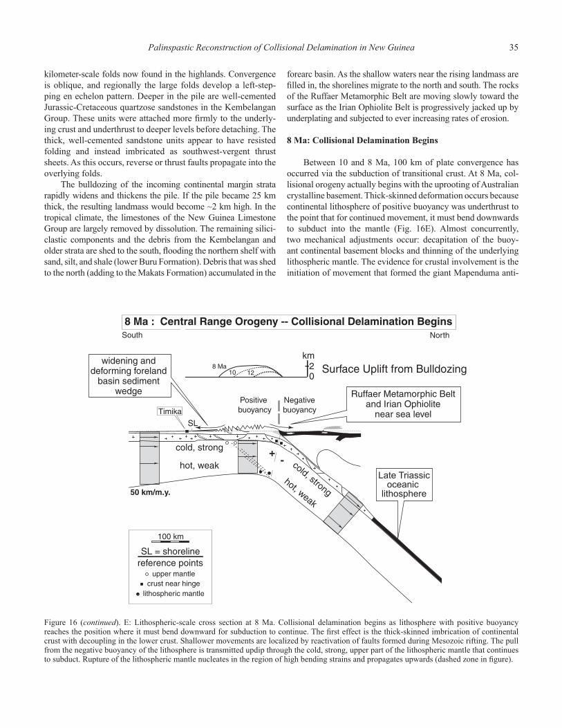
Palinspastic Reconstruction of Collisional Delamination in New Guinea 35
kilometer-scale folds now found in the highlands. Convergence is oblique, and regionally the large folds develop a left-step-ping en echelon pattern. Deeper in the pile are well-cemented Jurassic-Cretaceous quartzose sandstones in the Kembelangan Group. These units were attached more fi rmly to the underly-ing crust and underthrust to deeper levels before detaching. The thick, well-cemented sandstone units appear to have resisted folding and instead imbricated as southwest-vergent thrust sheets. As this occurs, reverse or thrust faults propagate into the overlying folds.
The bulldozing of the incoming continental margin strata rapidly widens and thickens the pile. If the pile became 25 km thick, the resulting landmass would become ~2 km high. In the tropical climate, the limestones of the New Guinea Limestone Group are largely removed by dissolution. The remaining silici-clastic components and the debris from the Kembelangan and older strata are shed to the south, fl ooding the northern shelf with sand, silt, and shale (lower Buru Formation). Debris that was shed to the north (adding to the Makats Formation) accumulated in the
forearc basin. As the shallow waters near the rising landmass are fi lled in, the shorelines migrate to the north and south. The rocks of the Ruffaer Metamorphic Belt are moving slowly toward the surface as the Irian Ophiolite Belt is progressively jacked up by underplating and subjected to ever increasing rates of erosion.
8 Ma: Collisional Delamination Begins
Between 10 and 8 Ma, 100 km of plate convergence has occurred via the subduction of transitional crust. At 8 Ma, col-lisional orogeny actually begins with the uprooting of Australian crystalline basement. Thick-skinned deformation occurs because continental lithosphere of positive buoyancy was underthrust to the point that for continued movement, it must bend downwards to subduct into the mantle (Fig. 16E). Almost concurrently, two mechanical adjustments occur: decapitation of the buoy-ant continental basement blocks and thinning of the underlying lithospheric mantle. The evidence for crustal involvement is the initiation of movement that formed the giant Mapenduma anti-
Figure 16 (continued). E: Lithospheric-scale cross section at 8 Ma. Collisional delamination begins as lithosphere with positive buoyancy reaches the position where it must bend downward for subduction to continue. The fi rst effect is the thick-skinned imbrication of continental crust with decoupling in the lower crust. Shallower movements are localized by reactivation of faults formed during Mesozoic rifting. The pull from the negative buoyancy of the lithosphere is transmitted updip through the cold, strong, upper part of the lithospheric mantle that continues to subduct. Rupture of the lithospheric mantle nucleates in the region of high bending strains and propagates upwards (dashed zone in fi gure).
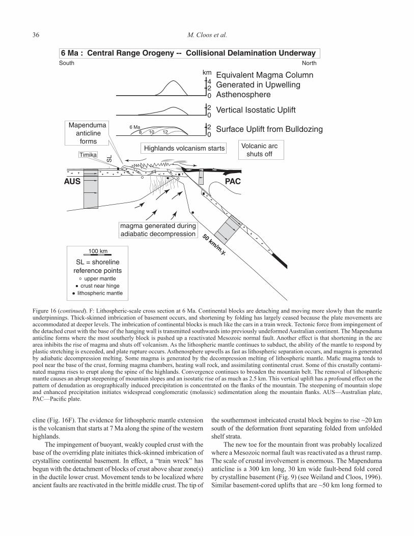
36 M. Cloos et al.
cline (Fig. 16F). The evidence for lithospheric mantle extension is the volcanism that starts at 7 Ma along the spine of the western highlands.
The impingement of buoyant, weakly coupled crust with the base of the overriding plate initiates thick-skinned imbrication of crystalline continental basement. In effect, a “train wreck” has begun with the detachment of blocks of crust above shear zone(s) in the ductile lower crust. Movement tends to be localized where ancient faults are reactivated in the brittle middle crust. The tip of
the southernmost imbricated crustal block begins to rise ~20 km south of the deformation front separating folded from unfolded shelf strata.
The new toe for the mountain front was probably localized where a Mesozoic normal fault was reactivated as a thrust ramp. The scale of crustal involvement is enormous. The Mapenduma anticline is a 300 km long, 30 km wide fault-bend fold cored by crystalline basement (Fig. 9) (see Weiland and Cloos, 1996). Similar basement-cored uplifts that are ~50 km long formed to
Figure 16 (continued). F: Lithospheric-scale cross section at 6 Ma. Continental blocks are detaching and moving more slowly than the mantle underpinnings. Thick-skinned imbrication of basement occurs, and shortening by folding has largely ceased because the plate movements are accommodated at deeper levels. The imbrication of continental blocks is much like the cars in a train wreck. Tectonic force from impingement of the detached crust with the base of the hanging wall is transmitted southwards into previously undeformed Australian continent. The Mapenduma anticline forms where the most southerly block is pushed up a reactivated Mesozoic normal fault. Another effect is that shortening in the arc area inhibits the rise of magma and shuts off volcanism. As the lithospheric mantle continues to subduct, the ability of the mantle to respond by plastic stretching is exceeded, and plate rupture occurs. Asthenosphere upwells as fast as lithospheric separation occurs, and magma is generated by adiabatic decompression melting. Some magma is generated by the decompression melting of lithospheric mantle. Mafi c magma tends to pool near the base of the crust, forming magma chambers, heating wall rock, and assimilating continental crust. Some of this crustally contami-nated magma rises to erupt along the spine of the highlands. Convergence continues to broaden the mountain belt. The removal of lithospheric mantle causes an abrupt steepening of mountain slopes and an isostatic rise of as much as 2.5 km. This vertical uplift has a profound effect on the pattern of denudation as orographically induced precipitation is concentrated on the fl anks of the mountain. The steepening of mountain slope and enhanced precipitation initiates widespread conglomeratic (molassic) sedimentation along the mountain fl anks. AUS—Australian plate, PAC—Pacifi c plate.
Palinspastic Reconstruction of Collisional Delamination in New Guinea 37
the west and east (Fig. 1). As the crystalline basement blocks move, the overlying precollision complex of deformed passive margin strata begins to raft southwards (Fig. 7). Folding defor-mation almost certainly slows and may even cease as plate con-vergence is accommodated within the ductile lower crust.
Below the level of crustal decapitation, another important phenomenon begins to manifest itself. The pull force from the negative buoyancy of the subducting lithosphere continues to transmit updip through the cold, strong, upper 30 km or so of the lithospheric mantle. Because relatively large differential stresses already exist in the area of bending, the hinge plays a critical role in localizing plate separation. What starts as ductile neck-ing (Fig. 16E) rapidly leads to rupture (Fig. 16F). The subduc-tion pull force remains steady, but the local differential stresses rapidly increase as the neck thins. Whether ruptures propagate upwards or downwards is unclear, but the net result is that the cool, dense, and strong tongue of upper lithospheric mantle pulls out from beneath the decapitated and imbricated blocks of crust and above the wedge of weak, nearly neutrally buoyant lower lithospheric mantle. The asthenosphere is already at a condition of incipient melting, and upwelling causes more melt to form. As the underlying wedge of lithospheric mantle stretches and decompresses, partial melting is initiated.
6 Ma: Thick-Skinned Deformation and Magmatism
Between 8 and 6 Ma, 100 km of additional plate conver-gence has occurred. At 6 Ma, collisional delamination of the lithosphere is well under way. Thick-skinned deformation cre-ates the south-vergent Mapenduma anticline. The effects of the collision are also transmitted northward, causing contraction of the thermally weakened lithosphere beneath the arc, and volca-nism along the north coast of the island shuts off. It is probable that some convergence was accommodated by reactivation of movement along the old subduction shear zone that reaches the surface at the New Guinea Trench. Beneath the orogenic belt, lithospheric mantle is replaced as asthenosphere rapidly upwells into the gap in the ruptured plate. As this occurs, the mountain-ous belt with peaks that were 2–3 km or so tall and generated by 10 m.y. of contractional deformation undergoes a vertical iso-static uplift in less than 2 m.y. that is as much as 2.5 km higher (timing and amounts discussed below) above the zone of maxi-mum upwelling. In other words, the core of the orogenic belt rapidly rose vertically about as much as the surface rose during the earlier prolonged phase of folding and faulting.
The upwelling asthenosphere undergoes adiabatic decom-pression melting in amounts proportional to the local amount of rise (volumes discussed below). The wedge of rising lower litho-spheric mantle extending north from beneath the Australian con-tinent is the piece that was beneath the pulled-out, strong tongue of uppermost mantle. This piece also undergoes decompression melting, but to a far smaller degree. In western New Guinea, the lithospheric mantle is Precambrian, which contributed a small, but isotopically distinctive component to the magmas (see
Housh and McMahon, 2000). The volumetrically minor, but widespread, collision-generated magmatism that intruded into deformed Australian passive margin strata is well dated in the western Central Range as a short-lived event between 7 Ma and 2.5 Ma (O’Connor et al., 1994; McDowell et al., 1996).
Magma intrusion and volcanism is concentrated along the spine of the highlands because the highest elevations develop above the zone of maximum asthenospheric upwelling and thus maximum magma generation. Mafi c magma from the mantle will pool and form chambers near the base of the crust. Lower crustal materials are assimilated by the engulfment of pieces and convective mixing of melted wall rock. The generation of magma chambers and wall-rock heating further weakens the crust and aids decoupling of the crust from the mantle.
In the case illustrated for the western Central Range (Figs. 16E, 16F, and 16G), only a relatively limited stretching of the underlying mantle occurs, and asthenosphere is shown to rise to the base of the crust. In other locations, mantle stretching may be substantial, and upwelling asthenosphere need not directly contact the base of the crust. Whether the asthenosphere upwells directly to the base of the crust or not must play a major role in controlling the amount of lower crustal melting that occurs. It will be argued that along-strike variations in the degree of stretching of lower lithospheric mantle can explain the lack of magmatism and the lesser topography of the middle segment of the Central Range.
4 Ma: Collisional Delamination is Complete
Between 6 and 4 Ma, ~100 km of plate convergence should have been distributed across the island; however, the collision has also begun to affect areas far to the north. At ca. 4 Ma, delam-ination of the Australian lithosphere is complete (Fig. 16G). Consequently, asthenospheric upwelling has ended, and magma generation is in the fi nal stages. Magma chambers in the lower crust are solidifying faster than new melt is added. The front of isostatic uplift has propagated northwards, and the edge of the Irian Ophiolite Belt is tilted upwards as it rises vertically ~2 km.
At this time, weak asthenosphere underlies the Central Range, and heating of the crust both conductively and from advection by rising magmas is at a maximum rate. Conse-quently, the rock strength beneath the mountain belt is low, and seismicity should be limited. This phenomenon would explain the perplexing scarcity of seismicity now detected in the Timor region as noted by Milsom et al. (1983).
The collision is having tectonic effects far to the north of the island. By the middle Cenozoic, plate motions between the Aus-tralian, Philippine, and Pacifi c plates were such that a prong of the Pacifi c plate extended between New Guinea and the Mariana subduction zone. The collision caused a suffi cient change in the force balance on the prong that it broke off and became a kine-matically distinct entity. The broken piece, the Caroline micro-plate (Fig. 1), moved more westerly and slightly more slowly than the parent Pacifi c plate.
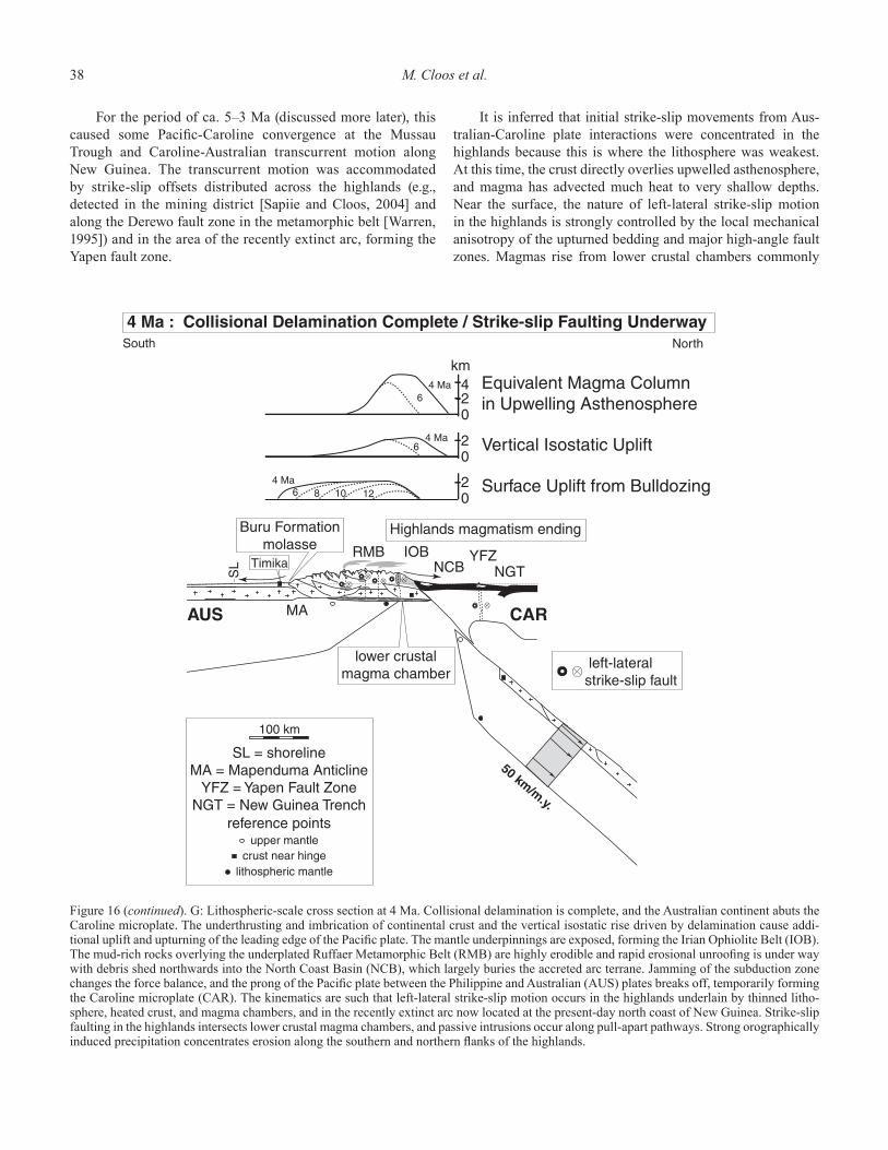
38 M. Cloos et al.
For the period of ca. 5–3 Ma (discussed more later), this caused some Pacifi c-Caroline convergence at the Mussau Trough and Caroline-Australian transcurrent motion along New Guinea. The transcurrent motion was accommodated by strike-slip offsets distributed across the highlands (e.g., detected in the mining district [Sapiie and Cloos, 2004] and along the Derewo fault zone in the metamorphic belt [Warren, 1995]) and in the area of the recently extinct arc, forming the Yapen fault zone.
It is inferred that initial strike-slip movements from Aus-tralian-Caroline plate interactions were concentrated in the highlands because this is where the lithosphere was weakest. At this time, the crust directly overlies upwelled asthenosphere, and magma has advected much heat to very shallow depths. Near the surface, the nature of left-lateral strike-slip motion in the highlands is strongly controlled by the local mechanical anisotropy of the upturned bedding and major high-angle fault zones. Magmas rise from lower crustal chambers commonly
Figure 16 (continued). G: Lithospheric-scale cross section at 4 Ma. Collisional delamination is complete, and the Australian continent abuts the Caroline microplate. The underthrusting and imbrication of continental crust and the vertical isostatic rise driven by delamination cause addi-tional uplift and upturning of the leading edge of the Pacifi c plate. The mantle underpinnings are exposed, forming the Irian Ophiolite Belt (IOB). The mud-rich rocks overlying the underplated Ruffaer Metamorphic Belt (RMB) are highly erodible and rapid erosional unroofi ng is under way with debris shed northwards into the North Coast Basin (NCB), which largely buries the accreted arc terrane. Jamming of the subduction zone changes the force balance, and the prong of the Pacifi c plate between the Philippine and Australian (AUS) plates breaks off, temporarily forming the Caroline microplate (CAR). The kinematics are such that left-lateral strike-slip motion occurs in the highlands underlain by thinned litho-sphere, heated crust, and magma chambers, and in the recently extinct arc now located at the present-day north coast of New Guinea. Strike-slip faulting in the highlands intersects lower crustal magma chambers, and passive intrusions occur along pull-apart pathways. Strong orographically induced precipitation concentrates erosion along the southern and northern fl anks of the highlands.
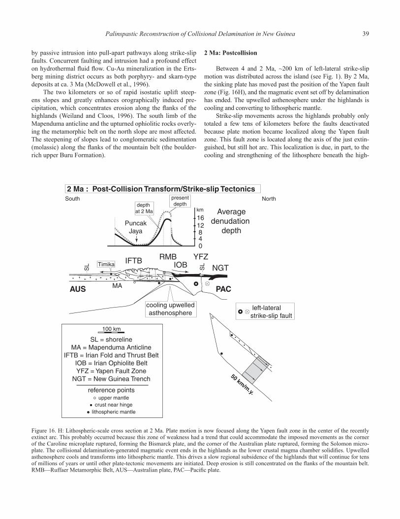
Palinspastic Reconstruction of Collisional Delamination in New Guinea 39
by passive intrusion into pull-apart pathways along strike-slip faults. Concurrent faulting and intrusion had a profound effect on hydrothermal fl uid fl ow. Cu-Au mineralization in the Erts-berg mining district occurs as both porphyry- and skarn-type deposits at ca. 3 Ma (McDowell et al., 1996).
The two kilometers or so of rapid isostatic uplift steep-ens slopes and greatly enhances orographically induced pre-cipitation, which concentrates erosion along the fl anks of the highlands (Weiland and Cloos, 1996). The south limb of the Mapenduma anticline and the upturned ophiolitic rocks overly-ing the metamorphic belt on the north slope are most affected. The steepening of slopes lead to conglomeratic sedimentation (molassic) along the fl anks of the mountain belt (the boulder-rich upper Buru Formation).
2 Ma: Postcollision
Between 4 and 2 Ma, ~200 km of left-lateral strike-slip motion was distributed across the island (see Fig. 1). By 2 Ma, the sinking plate has moved past the position of the Yapen fault zone (Fig. 16H), and the magmatic event set off by delamination has ended. The upwelled asthenosphere under the highlands is cooling and converting to lithospheric mantle.
Strike-slip movements across the highlands probably only totaled a few tens of kilometers before the faults deactivated because plate motion became localized along the Yapen fault zone. This fault zone is located along the axis of the just extin-guished, but still hot arc. This localization is due, in part, to the cooling and strengthening of the lithosphere beneath the high-
Figure 16. H: Lithospheric-scale cross section at 2 Ma. Plate motion is now focused along the Yapen fault zone in the center of the recently extinct arc. This probably occurred because this zone of weakness had a trend that could accommodate the imposed movements as the corner of the Caroline microplate ruptured, forming the Bismarck plate, and the corner of the Australian plate ruptured, forming the Solomon micro-plate. The collisional delamination-generated magmatic event ends in the highlands as the lower crustal magma chamber solidifi es. Upwelled asthenosphere cools and transforms into lithospheric mantle. This drives a slow regional subsidence of the highlands that will continue for tens of millions of years or until other plate-tectonic movements are initiated. Deep erosion is still concentrated on the fl anks of the mountain belt. RMB—Ruffaer Metamorphic Belt, AUS—Australian plate, PAC—Pacifi c plate.
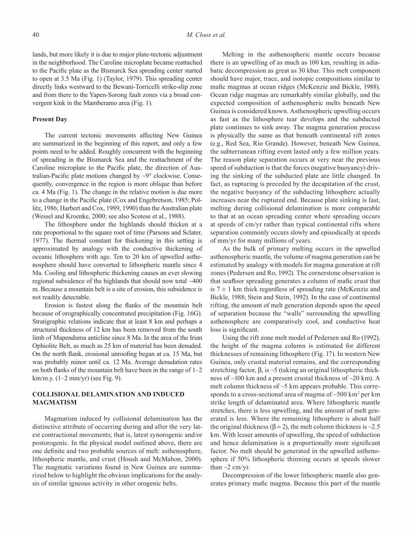
40 M. Cloos et al.
lands, but more likely it is due to major plate-tectonic adjustment in the neighborhood. The Caroline microplate became reattached to the Pacifi c plate as the Bismarck Sea spreading center started to open at 3.5 Ma (Fig. 1) (Taylor, 1979). This spreading center directly links westward to the Bewani-Torricelli strike-slip zone and from there to the Yapen-Sorong fault zones via a broad con-vergent kink in the Mamberamo area (Fig. 1).
Present Day
The current tectonic movements affecting New Guinea are summarized in the beginning of this report, and only a few points need to be added. Roughly concurrent with the beginning of spreading in the Bismarck Sea and the reattachment of the Caroline microplate to the Pacifi c plate, the direction of Aus-tralian-Pacifi c plate motions changed by ~9° clockwise. Conse-quently, convergence in the region is more oblique than before ca. 4 Ma (Fig. 1). The change in the relative motion is due more to a change in the Pacifi c plate (Cox and Engebretson, 1985; Pol-litz, 1986; Harbert and Cox, 1989, 1990) than the Australian plate (Wessel and Kroenke, 2000; see also Scotese et al., 1988).
The lithosphere under the highlands should thicken at a rate proportional to the square root of time (Parsons and Sclater, 1977). The thermal constant for thickening in this setting is approximated by analogy with the conductive thickening of oceanic lithosphere with age. Ten to 20 km of upwelled asthe-nosphere should have converted to lithospheric mantle since 4 Ma. Cooling and lithospheric thickening causes an ever slowing regional subsidence of the highlands that should now total ~400 m. Because a mountain belt is a site of erosion, this subsidence is not readily detectable.
Erosion is fastest along the fl anks of the mountain belt because of orographically concentrated precipitation (Fig. 16G). Stratigraphic relations indicate that at least 8 km and perhaps a structural thickness of 12 km has been removed from the south limb of Mapenduma anticline since 8 Ma. In the area of the Irian Ophiolite Belt, as much as 25 km of material has been denuded. On the north fl ank, erosional unroofi ng began at ca. 15 Ma, but was probably minor until ca. 12 Ma. Average denudation rates on both fl anks of the mountain belt have been in the range of 1–2 km/m.y. (1–2 mm/yr) (see Fig. 9).
COLLISIONAL DELAMINATION AND INDUCED MAGMATISM
Magmatism induced by collisional delamination has the distinctive attribute of occurring during and after the very lat-est contractional movements; that is, latest synorogenic and/or postorogenic. In the physical model outlined above, there are one defi nite and two probable sources of melt: asthenosphere, lithospheric mantle, and crust (Housh and McMahon, 2000). The magmatic variations found in New Guinea are summa-rized below to highlight the obvious implications for the analy-sis of similar igneous activity in other orogenic belts.
Melting in the asthenospheric mantle occurs because there is an upwelling of as much as 100 km, resulting in adia-batic decompression as great as 30 kbar. This melt component should have major, trace, and isotopic compositions similar to mafi c magmas at ocean ridges (McKenzie and Bickle, 1988). Ocean ridge magmas are remarkably similar globally, and the expected composition of asthenospheric melts beneath New Guinea is considered known. Asthenospheric upwelling occurs as fast as the lithosphere tear develops and the subducted plate continues to sink away. The magma generation process is physically the same as that beneath continental rift zones (e.g., Red Sea, Rio Grande). However, beneath New Guinea, the subterranean rifting event lasted only a few million years. The reason plate separation occurs at very near the previous speed of subduction is that the forces (negative buoyancy) driv-ing the sinking of the subducted plate are little changed. In fact, as rupturing is preceded by the decapitation of the crust, the negative buoyancy of the subducting lithosphere actually increases near the ruptured end. Because plate sinking is fast, melting during collisional delamination is more comparable to that at an ocean spreading center where spreading occurs at speeds of cm/yr rather than typical continental rifts where separation commonly occurs slowly and episodically at speeds of mm/yr for many millions of years.
As the bulk of primary melting occurs in the upwelled asthenospheric mantle, the volume of magma generation can be estimated by analogy with models for magma generation at rift zones (Pedersen and Ro, 1992). The cornerstone observation is that seafl oor spreading generates a column of mafi c crust that is 7 ± 1 km thick regardless of spreading rate (McKenzie and Bickle, 1988; Stein and Stein, 1992). In the case of continental rifting, the amount of melt generation depends upon the speed of separation because the “walls” surrounding the upwelling asthenosphere are comparatively cool, and conductive heat loss is signifi cant.
Using the rift zone melt model of Pedersen and Ro (1992), the height of the magma column is estimated for different thicknesses of remaining lithosphere (Fig. 17). In western New Guinea, only crustal material remains, and the corresponding stretching factor, β, is ~5 (taking an original lithospheric thick-ness of ~100 km and a present crustal thickness of ~20 km). A melt column thickness of ~5 km appears probable. This corre-sponds to a cross-sectional area of magma of ~500 km2 per km strike length of delaminated area. Where lithospheric mantle stretches, there is less upwelling, and the amount of melt gen-erated is less. Where the remaining lithosphere is about half the original thickness (β ≈ 2), the melt column thickness is ~2.5 km. With lesser amounts of upwelling, the speed of subduction and hence delamination is a proportionally more signifi cant factor. No melt should be generated in the upwelled astheno-sphere if 50% lithospheric thinning occurs at speeds slower than ~2 cm/yr.
Decompression of the lower lithospheric mantle also gen-erates primary mafi c magma. Because this part of the mantle
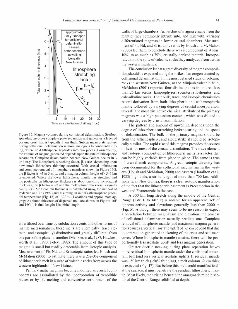
Palinspastic Reconstruction of Collisional Delamination in New Guinea 41
is fertilized over time by subduction events and other forms of mantle metasomatism, these melts are chemically (trace ele-ment and isotopically) distinctive and greatly different from one part of the planet to another (Menzies et al., 1987; Hawkes-worth et al., 1990; Foley, 1992). The amount of this type of magma is small but readily detectable from isotopic analysis. Measurement of Pb, Nd, and Sr isotopic ratios led Housh and McMahon (2000) to estimate there was a 2%–3% component of lithospheric melt in a suite of volcanic rocks from across the western highlands of New Guinea.
Primary mafi c magmas become modifi ed as crustal com-ponents are assimilated by the incorporation of xenolithic pieces or by the melting and convective entrainment of the
walls of large chambers. As batches of magma escape from the mantle, they commonly intrude into, and mix with, variably differentiated magmas in lower crustal chambers. Measure-ment of Pb, Nd, and Sr isotopic ratios by Housh and McMahon (2000) led them to conclude there was a component of at least 10%, to as much as 75%, crustally derived material incorpo-rated into the suite of volcanic rocks they analyzed from across the western highlands.
The conclusion is that a great diversity of magma composi-tion should be expected along the strike of an orogen created by collisional delamination. In the most detailed study of volcanic rocks in western New Guinea, at the Minjauh volcanic fi eld, McMahon (2001) reported four distinct suites in an area less than 25 km across: lamprophyres, syenites, shoshonites, and calc-alkaline rocks. Their bulk, trace, and isotopic chemistries record derivation from both lithospheric and asthenospheric mantle followed by varying degrees of crustal incorporation. Overall, the most distinctive chemical attribute of the primary magmas was a high potassium content, which was diluted to varying degrees by crustal assimilation.
The pattern and amount of upwelling depends upon the degree of lithospheric stretching before tearing and the speed of delamination. The bulk of the primary magma should be from the asthenosphere, and along strike it should be isotopi-cally similar. The rapid rise of this magma provides the source of heat for most of the crustal assimilation. The trace element and isotopic composition of lithospheric melts is a factor that can be highly variable from place to place. The same is true of crustal melt components. A great isotopic diversity has been documented for the collisional magmatism in the west-ern (Housh and McMahon, 2000) and eastern (Hamilton et al., 1983) highlands, a strike length of more than 700 km. Addi-tionally, in New Guinea, there is a clear isotopic manifestation of the fact that the lithospheric basement is Precambrian in the west and Phanerozoic in the east.
A 300 km long stretch along the middle of the Central Range (138° E to 141° E) is notable for an apparent lack of igneous activity and elevations generally less than 2000 m (Fig. 5). Although there may seem to be no reason to expect a correlation between magmatism and elevation, the process of collisional delamination actually predicts one. Complete removal of lithospheric mantle (and maximum magma genera-tion) causes a vertical isostatic uplift of ~2 km beyond that due to contraction-generated thickening of the crust and sediment cover. Where lithospheric mantle remains, there will be pro-portionally less isostatic uplift and less magma generation.
Greater ductile necking during plate separation leaves more residual lithospheric mantle under the collisional moun-tain belt (and less vertical isostatic uplift). If residual mantle was ~50 km thick (~50% thinning), a melt column ~2 km thick is expected (Fig. 17). But before this melt could manifest itself at the surface, it must penetrate the residual lithospheric man-tle. Most likely, melt rising beneath the amagmatic middle sec-tor of the Central Range solidifi ed at depth.
Figure 17. Magma volumes during collisional delamination. Seafl oor spreading involves complete plate separation and generates a layer of oceanic crust that is typically 7 km thick. Subterranean plate rupture during collisional delamination is more analogous to continental rift-ing, where cold lithosphere separates into two pieces. Consequently, the volume of magma generated depends upon the rate of lithospheric separation. Complete delamination beneath New Guinea occurs in 3 or 4 m.y. The lithospheric stretching factor, β, varies depending upon how much lithosphere thinning occurred. With crustal imbrication and complete removal of lithospheric mantle as shown in Figure 16G, the β factor is ~5 in 3 m.y., and a magma column height of ~5–6 km is expected. Where the lower lithospheric mantle has stretched and the postcollision lithosphere thickness is about one-third the original thickness, the β factor is ~2 and the melt column thickness is signifi -cantly less. Melt column thickness is calculated using the method of Pedersen and Ro (1992) and assuming an initial asthenosphere poten-tial temperature (Fig. 15) of 1300 °C. Locations and approximate ag-gregate column thickness of dispersed melt are shown on Figures 16F and 16G. l
f is fi nal length; l
i is initial length
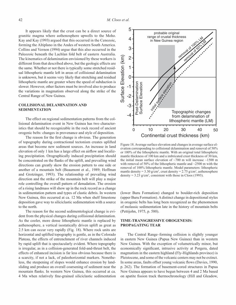
42 M. Cloos et al.
It appears likely that the crust can be a direct source of granitic magma where asthenosphere upwells to the Moho. Kay and Kay (1993) argued that this occurred in the Cenozoic, forming the Altiplano in the Andes of western South America. Collins and Vernon (1994) argue that this also occurred in the Paleozoic beneath the Lachlan fold belt of eastern Australia. The kinematics of delamination envisioned by these workers is different from that described above, but the geologic effects are the same. Whether or not there is typically some stretched resid-ual lithospheric mantle left in areas of collisional delamination is unknown, but it seems very likely that stretching and residual lithospheric mantle are greater where the speed of subduction is slower. However, other factors must be involved also to produce the variations in magmatism observed along the strike of the Central Range of New Guinea.
COLLISIONAL DELAMINATION AND SEDIMENTATION
The effect on regional sedimentation patterns from the col-lisional delamination event in New Guinea has two character-istics that should be recognizable in the rock record of ancient orogenic belts: changes in provenance and style of deposition.
The reason for the fi rst change is obvious. The generation of topography during contractional tectonism creates uplifted areas that become new sediment sources. An increase in land elevation of only 1 km has a large effect on airfl ow and localiz-ing precipitation. Orographically induced precipitation should be concentrated on the fl anks of the uplift, and prevailing wind directions can greatly skew the erosion pattern to one side or another of a mountain belt (Beaumont et al., 1989; Hoffman and Grotzinger, 1993). The relationship of prevailing wind direction and the strike of the mountain belt will play a major role controlling the overall pattern of denudation. The erosion of a rising landmass will show up in the rock record as a change in sedimentation pattern and types of clastic debris. In western New Guinea, this occurred at ca. 12 Ma when shelf limestone deposition gave way to siliciclastic sedimentation with a source to the north.
The reason for the second sedimentological change is evi-dent from the physical changes during collisional delamination. As the cooler, more dense lithospheric mantle is replaced by asthenosphere, a vertical isostatically driven uplift as great as 2.5 km can occur very rapidly (Fig. 18). Where rock units are horizontal and uplifted topography is gentle, as in the Colorado Plateau, the effects of entrenchment of river channels induced by rapid uplift that is spectacularly evident. Where topography is irregular, as in a collision-generated fold-and-thrust belt, the effects of enhanced incision is far less obvious because there is a scarcity, if not a lack, of paleohorizontal markers. Nonethe-less, the steepening of slopes would enhance erosion by land-sliding and produce an overall coarsening of sediment near the mountain fl anks. In western New Guinea, this occurred at ca. 4 Ma when relatively fi ne-grained siliciclastic sedimentation
(lower Buru Formation) changed to boulder-rich deposition (upper Buru Formation). A distinct change in depositional styles in orogenic belts has long been recognized as the phenomenon of molassic sedimentation late in the history of mountain belts (Pettijohn, 1975, p. 580).
TIME-TRANSGRESSIVE OROGENESIS: PROPAGATING TEAR
The Central Range–forming collision is slightly younger in eastern New Guinea (Papua New Guinea) than in western New Guinea. With the exception of volumetrically minor, but economically signifi cant, intrusive activity at Porgera, dated magmatism in the eastern highland (Fly-Highlands province) is Pleistocene, and some of the volcanic centers may not be extinct. In some areas, faults offset young volcanic fl ows (Davies, 1990, p. 262). The formation of basement-cored structures in Papua New Guinea appears to have begun between 4 and 2 Ma based on apatite fi ssion track thermochronology (Hill and Gleadow,
Figure 18. Average surface elevation and changes in average surface el-evation corresponding to collisional delamination and removal of 50% or 100% of the lithospheric mantle. With an original total lithospheric mantle thickness of 100 km and a imbricated crust thickness of 30 km, the initial mean surface elevation of ~700 m will increase ~1500 m with removal of 50% of the lithospheric mantle and ~2500 m with the removal of 100% lithospheric mantle. Model parameters: lithospheric mantle density = 3.30 g/cm3, crust density = 2.75 g/cm3, asthenosphere density = 3.23 g/cm3, consistent with those in Cloos (1993).
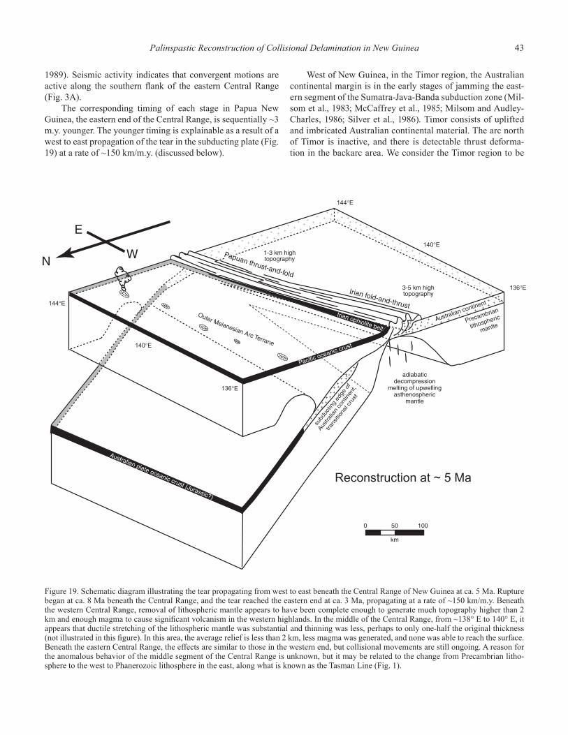
Palinspastic Reconstruction of Collisional Delamination in New Guinea 43
1989). Seismic activity indicates that convergent motions are active along the southern fl ank of the eastern Central Range (Fig. 3A).
The corresponding timing of each stage in Papua New Guinea, the eastern end of the Central Range, is sequentially ~3 m.y. younger. The younger timing is explainable as a result of a west to east propagation of the tear in the subducting plate (Fig. 19) at a rate of ~150 km/m.y. (discussed below).
West of New Guinea, in the Timor region, the Australian continental margin is in the early stages of jamming the east-ern segment of the Sumatra-Java-Banda subduction zone (Mil-som et al., 1983; McCaffrey et al., 1985; Milsom and Audley-Charles, 1986; Silver et al., 1986). Timor consists of uplifted and imbricated Australian continental material. The arc north of Timor is inactive, and there is detectable thrust deforma-tion in the backarc area. We consider the Timor region to be
Figure 19. Schematic diagram illustrating the tear propagating from west to east beneath the Central Range of New Guinea at ca. 5 Ma. Rupture began at ca. 8 Ma beneath the Central Range, and the tear reached the eastern end at ca. 3 Ma, propagating at a rate of ~150 km/m.y. Beneath the western Central Range, removal of lithospheric mantle appears to have been complete enough to generate much topography higher than 2 km and enough magma to cause signifi cant volcanism in the western highlands. In the middle of the Central Range, from ~138° E to 140° E, it appears that ductile stretching of the lithospheric mantle was substantial and thinning was less, perhaps to only one-half the original thickness (not illustrated in this fi gure). In this area, the average relief is less than 2 km, less magma was generated, and none was able to reach the surface. Beneath the eastern Central Range, the effects are similar to those in the western end, but collisional movements are still ongoing. A reason for the anomalous behavior of the middle segment of the Central Range is unknown, but it may be related to the change from Precambrian litho-sphere to the west to Phanerozoic lithosphere in the east, along what is known as the Tasman Line (Fig. 1).
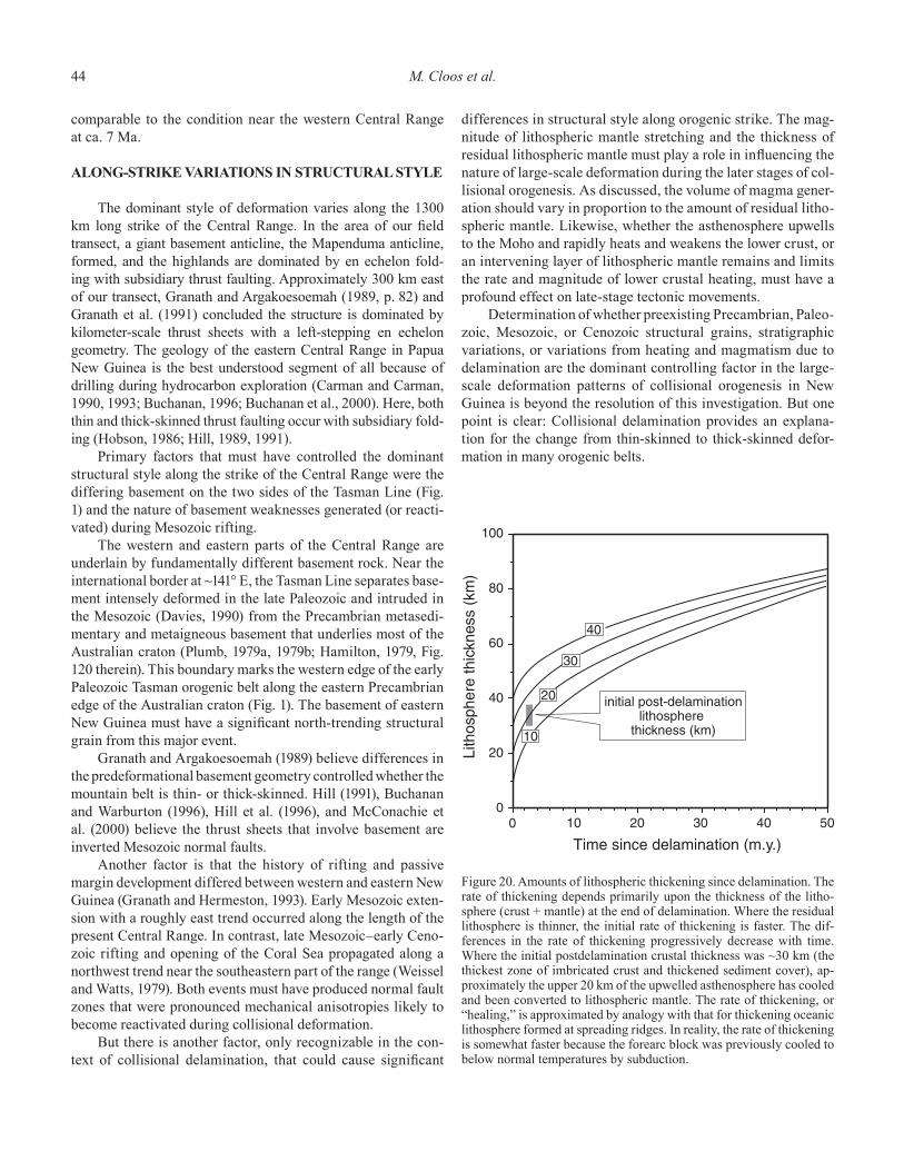
44 M. Cloos et al.
comparable to the condition near the western Central Range at ca. 7 Ma.
ALONG-STRIKE VARIATIONS IN STRUCTURAL STYLE
The dominant style of deformation varies along the 1300 km long strike of the Central Range. In the area of our fi eld transect, a giant basement anticline, the Mapenduma anticline, formed, and the highlands are dominated by en echelon fold-ing with subsidiary thrust faulting. Approximately 300 km east of our transect, Granath and Argakoesoemah (1989, p. 82) and Granath et al. (1991) concluded the structure is dominated by kilometer-scale thrust sheets with a left-stepping en echelon geometry. The geology of the eastern Central Range in Papua New Guinea is the best understood segment of all because of drilling during hydrocarbon exploration (Carman and Carman, 1990, 1993; Buchanan, 1996; Buchanan et al., 2000). Here, both thin and thick-skinned thrust faulting occur with subsidiary fold-ing (Hobson, 1986; Hill, 1989, 1991).
Primary factors that must have controlled the dominant structural style along the strike of the Central Range were the differing basement on the two sides of the Tasman Line (Fig. 1) and the nature of basement weaknesses generated (or reacti-vated) during Mesozoic rifting.
The western and eastern parts of the Central Range are underlain by fundamentally different basement rock. Near the international border at ~141° E, the Tasman Line separates base-ment intensely deformed in the late Paleozoic and intruded in the Mesozoic (Davies, 1990) from the Precambrian metasedi-mentary and metaigneous basement that underlies most of the Australian craton (Plumb, 1979a, 1979b; Hamilton, 1979, Fig. 120 therein). This boundary marks the western edge of the early Paleozoic Tasman orogenic belt along the eastern Precambrian edge of the Australian craton (Fig. 1). The basement of eastern New Guinea must have a signifi cant north-trending structural grain from this major event.
Granath and Argakoesoemah (1989) believe differences in the predeformational basement geometry controlled whether the mountain belt is thin- or thick-skinned. Hill (1991), Buchanan and Warburton (1996), Hill et al. (1996), and McConachie et al. (2000) believe the thrust sheets that involve basement are inverted Mesozoic normal faults.
Another factor is that the history of rifting and passive margin development differed between western and eastern New Guinea (Granath and Hermeston, 1993). Early Mesozoic exten-sion with a roughly east trend occurred along the length of the present Central Range. In contrast, late Mesozoic–early Ceno-zoic rifting and opening of the Coral Sea propagated along a northwest trend near the southeastern part of the range (Weissel and Watts, 1979). Both events must have produced normal fault zones that were pronounced mechanical anisotropies likely to become reactivated during collisional deformation.
But there is another factor, only recognizable in the con-text of collisional delamination, that could cause signifi cant
differences in structural style along orogenic strike. The mag-nitude of lithospheric mantle stretching and the thickness of residual lithospheric mantle must play a role in infl uencing the nature of large-scale deformation during the later stages of col-lisional orogenesis. As discussed, the volume of magma gener-ation should vary in proportion to the amount of residual litho-spheric mantle. Likewise, whether the asthenosphere upwells to the Moho and rapidly heats and weakens the lower crust, or an intervening layer of lithospheric mantle remains and limits the rate and magnitude of lower crustal heating, must have a profound effect on late-stage tectonic movements.
Determination of whether preexisting Precambrian, Paleo-zoic, Mesozoic, or Cenozoic structural grains, stratigraphic variations, or variations from heating and magmatism due to delamination are the dominant controlling factor in the large-scale deformation patterns of collisional orogenesis in New Guinea is beyond the resolution of this investigation. But one point is clear: Collisional delamination provides an explana-tion for the change from thin-skinned to thick-skinned defor-mation in many orogenic belts.
Figure 20. Amounts of lithospheric thickening since delamination. The rate of thickening depends primarily upon the thickness of the litho-sphere (crust + mantle) at the end of delamination. Where the residual lithosphere is thinner, the initial rate of thickening is faster. The dif-ferences in the rate of thickening progressively decrease with time. Where the initial postdelamination crustal thickness was ~30 km (the thickest zone of imbricated crust and thickened sediment cover), ap-proximately the upper 20 km of the upwelled asthenosphere has cooled and been converted to lithospheric mantle. The rate of thickening, or “healing,” is approximated by analogy with that for thickening oceanic lithosphere formed at spreading ridges. In reality, the rate of thickening is somewhat faster because the forearc block was previously cooled to below normal temperatures by subduction.
Palinspastic Reconstruction of Collisional Delamination in New Guinea 45
LITHOSPHERIC HEALING AFTER DELAMINATION
The delamination of the lithospheric mantle beneath the core of the highlands led to the rapid upwelling of the asthenosphere. The upwelled material is cooling and converting to lithosphere at a rate that depends upon the thickness of the overlying sediment cover, crust, and residual lithospheric mantle. The rate of thick-ening of the lithospheric mantle under mountain belts is approxi-mated by analogy with the thickening of oceanic lithosphere over time. The initial rate of lithospheric mantle thickening is esti-mated to be similar to that occurring beneath oceanic lithosphere of similar thickness (Fig. 20). Assuming an initial crustal thick-ness of 20 km beneath the spine of the western Central Range and 100% removal of the underlying lithospheric mantle, a 10–20 km thickness of asthenosphere has already been converted into lithospheric mantle beneath the western Central Range.
Cooling and conversion of asthenospheric mantle to litho-sphere will cause a steady subsidence of the mountain belt. Again, the analogy with ocean spreading ridges, is appropriate. After complete removal of lithospheric mantle, regional subsid-ence will occur at an average rate of ~100 m/m.y. for the fi rst 10 m.y. after the event, steadily slowing thereafter. Of course, mountain peaks can still be rising as the regional base level is lowering.
PLATE-TECTONIC CHANGES RELATED TO THE COLLISION FORMING NEW GUINEA: NEARBY AND TRANSOCEANIC
The jamming of a subduction zone will change the force bal-ance on the edges of the colliding plates. It would seem that the magnitude of the change should be proportional to the length of the collision zone and the geometry of the relative motions. Two end-member tectonic responses appear likely: continued plate convergence as before (at least for a short time) prior to subduc-tion reversal behind the oceanic arc, or a fundamental change in the relative motion between the colliding plates. The latter occurred, at least to some degree, as the aftermath of the oblique collision forming New Guinea.
As discussed, the Caroline microplate formed as the prong of the Pacifi c plate wedged between the Australian and Philippine plates, broke off, and began to move as a distinct kinematic entity at ca. 5 Ma. This movement produced strike-slip faulting in the collision-generated New Guinea highlands and in the still-warm core of the accreted arc terrane. At ca. 3.5 Ma, two other plate ruptures occurred nearby, which must also have been a manifes-tation of the collision forming the island (Fig. 4). A corner of the Pacifi c plate broke off, forming the Bismarck microplate (Taylor, 1979), and a propagating tear in the northeast corner of the Australian plate formed the Woodlark spreading center east of the island (Weissel et al., 1982; Honza et al., 1987). As these plate ruptures occurred and the spreading center opened, strike-slip activity became concentrated along the Yapen-Sorong and Bewani-Torricelli fault zones, which became active at ca. 4 Ma
based upon the time when pull-apart spreading became active in the Salawati Basin (Fig. 1) (Froidevaux, 1978; Charlton, 1996).
These plate motion changes have caused the ongoing col-lision in eastern New Guinea to differ from that in the west. Spreading in the Bismarck Sea has created the Bismarck plate, and the Finnisterre/Huon–New Britain Arc forearc is no longer part of the Pacifi c plate. The consequence of this is that the geom-etry of ongoing collision in eastern New Guinea is much less oblique than it was before 3 Ma.
New Guinea may be a bit unusual in that the later part of the collisional delamination process was concurrent with a major change in overall tectonic movements to ones dominated by strike slip (explained below). In many, if not most, collision zones, it appears convergent motion continues after collisional delamina-tion begins. When this occurs, lithospheric shortening will occur within the core of the collision-generated mountain belt and within the region of the recently extinct arc. Under the arc, there is an ~50 km wide zone of thermally thinned lithosphere. Under the mountain belt, there is typically an ~100 km wide zone lack-ing lithospheric mantle. Convergence at subduction speeds of a few cm/yr would take only a few million years to contract the thermally thinned lithosphere under the arc region and fi ll the gap under the arc and orogenic belt. As this occurs, lithospheric shortening must occur within both areas. If the motion of the two plates continues as before, a new subduction zone must form, and it should typically nucleate within the thermally weakened area of oceanic arcs. Once a new subduction zone is established, steady convergence, but with a reversal of polarity, can continue for many tens of millions of years. In the case of New Guinea, subduction reversal appears to be just starting after an ~5 m.y. period of adjustment dominated by strike-slip, transform move-ments. The New Guinea Trench is reactivating from the east to the west (Figs. 1 and 4).
The change in force balance was not only suffi cient to break pieces off the nearby corners of the Pacifi c and Australian plates, but enough to cause an ~9° clockwise rotation of the giant Pacifi c plate. The effects are detectable across the Pacifi c Basin. The San Andreas system of California (Pollitz, 1988; Harbert, 1991; Page and Brocher, 1993), the Queen Charlotte system in southeastern Alaska (Fitzgerald et al., 1993; Hyndman and Hamilton, 1993), and the Alpine system of New Zealand (Adams, 1981) have all become slightly convergent transform margins since the Pliocene. Signifi cant adjustments along the East Pacifi c Rise, besides small changes in spreading rate and optimal transform orientation, are the rupture of plate corners along the transform forming the Eas-ter and Juan Fernandez microplates (Searle et al., 1993). Because subduction zones ring most of the Pacifi c, the small change in Pacifi c plate motion makes only a small change in the speed and direction of convergence that by itself is probably essentially undetectable in the rock record. However, in some places, such as the Alaska-Aleutian Trench, the uplift of coastal mountains has greatly increased the sediment supply to the trench, and this in turn can cause a profound change in accretionary patterns (see the role of sediment supply in Shreve and Cloos, 1986).
46 References Cited
CONCLUSIONS
The formation of the island of New Guinea has long been cited as the product of a Cenozoic arc-continent collision. Geologic studies in the Central Range of western New Guinea (near Puncak Jaya, 4884 m) have revealed fi eld and timing relationships, which combined with mechanical considerations leads to a refi ned model for the tectono-magmatic effects of collisional orogenesis.
North-dipping subduction of the oceanic end of the Aus-tralian plate began at ca. 30 Ma at an intraoceanic subduc-tion zone, following a subduction reversal event beneath the Outer Melanesian Arc. Sediment accretion and metamorphism began soon after as continental sediment was transported far out to sea along the trench. Peak metamorphic temperatures were attained between 28 and 20 Ma. The top of an accretion-ary prism formed small islands by ca. 15 Ma. By ca. 12 Ma, a widespread landmass was shedding siliciclastic detritus to the south, fl ooding the carbonate shelf. Jamming of the subduc-tion zone by the underthrusting of the Australian continental-crust-capped plate began at ca. 8 Ma, with the detachment and southward displacement of the large basement block forming the Mapenduma anticline. The subducted oceanic end of the Australian plate continued to sink and broke off. The subter-ranean rifting, or delamination, of the Australian plate caused a magma generation event beneath the western Central Range from 7 to 4 Ma. Concurrently, the upwelling of asthenosphere caused a rapid, isostatically driven vertical uplift as great as 2.5 km of the collision-generated fold belt. This caused a profound change in regional sedimentation, forming molassic boulder beds near the mountain fl anks.
Collisional delamination is a common and fundamental plate-tectonic process that occurs when subduction zones are jammed by continental margins or very large oceanic arc/pla-teau complexes. Subterranean plate rifting is as fundamental to the end of the long-term history of steady subduction as the rifting process is to the beginning of seafl oor spreading and long-term, steady subsidence of a passive margin.
ACKNOWLEDGMENTS
This paper is based primarily upon theses and dissertations by students at the University of Texas, Austin, that were made possible by the assistance of the P.T. Freeport Indonesia (PTFI) exploration and mine geology departments. The 200+ geoscientists who staffed these departments during the 1990s provided the foundation for selecting sites for our fi eldwork that was followed by laboratory analysis of collected samples. We especially thank James R. Moffett, president and CEO of Freeport McMoRan and Robert E. Boyer, dean and professor of geological sciences at the University of Texas at Austin, whose vision made the Ertsberg Project a unique industry-academia initiative to better understand the geology of western New Guinea.
Vice Presidents Dave Potter and Steve Van Nort encour-aged the overall program and provided exceptional advice. Mine District Geologists Tom Collinson, Dave Mayes, Chuck Brannon, Al Edwards, and Larry Segretson provided guidance and assistance for the studies in the Ertsberg (Gunung Bijih) mining district. Head Exploration Geologists Peter Doyle, Gary Artmont, Wahyu Sunyoto, Gary O’Connor, and Sugeng Widodo provided guidance and assistance for our regional studies that rode on the coattails of the minerals exploration program.
Geologists and related staff who provided discussion and special assistance during one or more phases of our work include Kris Hefton, Jay Pennington, George MacDonald, Uttu Mekel, Keith Parris, Bambang Trisetyo, Lasito Soebari, Peter Sedgwick, Ian Tasiran, Art Ona, Mark Gilliam, Boedi-yono, Imants Kavalieris, Mike Burson, Larry Johnson, Soeba-gio Sopareman, Louie Bell, Sanusi Sukarya, Bambang Irawan, Eddy Suwardy, Erwin Siregar, Judihandri, Gandhi Hermawan, Nurhamid, Nurhadi, Eddy Bastomi, Herry Susanto, Djoko Waskito, Djuharlan, Budi Cahyono, Rudy Poedjono, Roga Pendawalima, Syaiful Bahri, Doug MacKenzie, Frachrudin Ali, Clark Arnold, Allen Schappert, Hamish Campbell, Joe McPherson, Ben Coutts, Dean Wadsworth, Fanfan, Slamet Riyanto, Steve Hughes, Ahmed, Ari Suldjana, and Rahmat Wirawan.
An extra special thanks to our Papuan fi eld assistants, Ayub “Obi” Zagani, Amelius Beanal, Julianus Magal, Etinus Tabuni, Dominikus Mom, Tiranus Beanal, Benny Dolame, Peniel Kogoya, Petrus Mote, Emi Tabuni, Lanus Owaling, and many others who showed us the natural wonders of their home-land.
We also thank all of our colleagues at our collaborating university, the Institut Teknologi Bandung (ITB). We specifi -cally thank Professors Iman Soengkowo, R.P. Koesoemadinata, Rubini Soeria-Atmadja, Yahdi Zaim, and Emmy Suparka.
We thank Fred McDowell, Jim Connelly, Todd Housh, W.R. Muehlberger, and W.R. Dickinson for reviews of this paper. Ertsberg Project Contribution No. 25.
REFERENCES CITED
Abbott, L.D., Silver, E.A., Thompson, P.R., Filewicz, M.V., Schneider, C., and Abdoerrias, 1994a, Stratigraphic constraints on the development and tim-ing of arc-continent collision in northern Papua New Guinea: Journal of Sedimentary Research, v. 64, p. 169–183.
Abbott, L.D., Silver, E.A., and Galewsky, J., 1994b, Structural evolution of a modern arc-continent collision in Papua New Guinea: Tectonics, v. 13, p. 1007–1034, doi: 10.1029/94TC01623.
Abers, G., and McCaffrey, R., 1988, Active deformation in the New Guinea fold-and-thrust belt: Seismological evidence for strike-slip faulting and basement involved thrusting: Journal of Geophysical Research, v. 93, p. 13,332–13,354.
Adams, C.J., 1981, Uplift rates and thermal structure in the Alpine fault zone and Alpine schists, southern Alps, New Zealand, in Price, N.J., and McClay, K.R., eds., Thrust and nappe tectonics: Geological Society [Lon-don] Special Publication 9, p. 211–222.
Anderson, D.L., 1989, Theory of the Earth: Boston, Blackwell Scientifi c Publications, 366 p.
References Cited 47
Atkinson, B.K., 1987, Introduction to fracture mechanics and its geophysical applications, in Atkinson, B.K., ed., Fracture mechanics of rock: Lon-don, Academic Press, p. 1–26.
Australasian Petroleum Company, 1961, Geological results of petroleum exploration in western Papua, 1937–1961: Geological Society of Austra-lia Journal, v. 8, p. 1–133.
Bär, C.B., Cortel, H.J., and Escher, A.E., 1961, Geological results of the Star Mountains (“Sterrengebergte”) Expedition: Nova Guinea, Geology, v. 4, p. 40–99.
Beaumont, C., Fullsack, P., and Hamilton, J., 1989, Erosional control of active compressional orogens, in McClay, K.R., ed., Thrust tectonics: New York, Chapman and Hall, p. 1–18.
Bird, P., 1978, Initiation of intracontinental subduction in the Himalaya: Jour-nal of Geophysical Research, v. 83, p. 4975–4987.
Bird, P., 1979, Continental delamination and the Colorado Plateau: Journal of Geophysical Research, v. 84, p. 7561–7571.
Bird, P., and Baumgardner, J., 1981, Steady propagation of delamination events: Journal of Geophysical Research, v. 86, p. 4891–4903.
Bladon, G.M., 1988, Catalogue, appraisal, and signifi cance of K-Ar isotopic ages determined for igneous and metamorphic rocks in Irian Jaya: Irian Jaya Geological Mapping Project, Geological Research and Develop-ment Centre, Indonesia, in cooperation with the Bureau of Mineral Resources, Australia, on behalf of the Department of Mines and Energy, Indonesia, and the Australian Development Assistance Bureau, 75 p.
Bloomer, S.H., 1983, Distribution and origin of igneous rocks from the land-ward slopes of the Mariana Trench: Implications for its structure and evolution: Journal of Geophysical Research, v. 88, p. 7411–7428.
Bond, G.C., and Kominz, M.A., 1988, Evolution of thought on passive conti-nental margins from the origin of geosynclinal theory (ca. 1860) to the present: Geological Society of America Bulletin, v. 100, p. 1909–1933, doi: 10.1130/0016-7606(1988)100<1909:EOTOPC>2.3.CO;2.
Brace, W.F., and Kohlstedt, D.L., 1980, Limits on lithospheric stress imposed by laboratory experiments: Journal of Geophysical Research, v. 85, p. 6248–6252.
Brown, C.M., Pigram, C.J., and Skwarko, S.K., 1979, Mesozoic stratigraphy and geological history of Papua New Guinea: Palaeogeography, Pal-aeoclimatology, Palaeoecology, v. 29, p. 301–322, doi: 10.1016/0031-0182(79)90087-7.
Buchanan, P.G., editor, 1996, Petroleum exploration, development and pro-duction in Papua New Guinea: Proceedings of the Third Papua New Guinea Petroleum Convention, Port Moresby, 9–11 September 1996, 822 p.
Buchanan, P.G., and Warburton, J., 1996, The infl uence of preexisting basin architecture in the development of the Papuan fold and thrust belt: Implications for petroleum prospectivity, in Buchanan, P.G., ed., Petro-leum exploration, development and production in Papua New Guinea: Proceedings of the 3rd Papua New Guinea Petroleum Convention, Port Moresby, 9–11 September 1996, p. 89–109.
Buchanan, P.G., Grainge, A.M., and Thornton, C.N., editors, 2000, Papua New Guinea’s petroleum industry in the 21st century: Proceedings of the Fourth Papua New Guinea Petroleum Convention, Port Moresby, 29–31 May 2000, 593 p.
Cardwell, R.K., Isacks, B.L., and Karig, D.E., 1980, The spatial distribution of earthquakes, focal mechanisms solutions, and subducted lithosphere in the Philippine and northeastern Indonesian islands: American Geo-physical Union Monograph 23, p. 1–35.
Carman, G.J., and Carman, Z., editors, 1990, Petroleum exploration in Papua New Guinea: Proceedings of the First Papua New Guinea Petroleum Convention, Port Moresby, 12–14 February 1990, 597 p.
Carman, G.J., and Carman, Z., editors, 1993, Petroleum exploration in Papua New Guinea: Proceedings of the Second Papua New Guinea Petroleum Convention, Port Moresby, 31 May–2 June 1993, 687 p.
Carter, N.L., 1976, Steady-state fl ow of rocks: Reviews of Geophysics and Space Physics, v. 14, p. 301–360.
Carter, N.L., and Tsenn, M.C., 1987, Flow properties of continental lithosphere: Tectonophysics, v. 136, p. 27–63, doi: 10.1016/0040-1951(87)90333-7.
Casey, J.F., and Dewey, J.F., 1984, Initiation of subduction zones along transform and accreting plate boundaries, triple-junction evolution, and forearc spreading centres—Implications for ophiolitic geology and obduction: Geological Society [London] Special Publication 13, p. 269–290.
Chappell, J., 1974, Geology of coral terraces, Huon Peninsula, New Guinea: A study of quaternary tectonic movements and sea-level changes: Geolog-
ical Society of America Bulletin, v. 85, p. 553–570, doi: 10.1130/0016-7606(1974)85<553:GOCTHP>2.0.CO;2.
Charlton, T.R., 1996, Correlation of the Salawati and Tomori Basins, eastern Indonesia: A constraint on left-lateral displacements of the Sorong fault zone: Geological Society [London] Special Publication 106, p. 465–481.
Cloos, M., 1985, Thermal evolution of convergent plate margins: Thermal modeling and re-evaluation of isotopic Ar-ages for blueschists in the Franciscan complex of California: Tectonics, v. 4, p. 421–433.
Cloos, M., 1992a, Thrust-type subduction-zone earthquakes and seamount asperities: A physical model for seismic rupture: Geology, v. 20, p. 601–604, doi: 10.1130/0091-7613(1992)020<0601:TTSZEA>2.3.CO;2.
Cloos, M., 1992b, Origin of the Caroline block and plate: Tectonic response to changes in Pacifi c plate motion at 43 and 4 Ma: Geological Society of America Abstracts with Programs, v. 24, no. 7, p. A185.
Cloos, M., 1993, Lithospheric buoyancy and collisional orogenesis: Subduction of oceanic plateaus, continental margins, island arcs, spreading ridges, and seamounts: Geological Society of America Bulletin, v. 105, p. 715–737, doi: 10.1130/0016-7606(1993)105<0715:LBACOS>2.3.CO;2.
Cloos, M., 1997a, Geology and the Grasberg: A model for joint industry and academic research: Geotimes, v. 42, no. 9, p. 19–22.
Cloos, M., 1997b, Anatomy of a mine: The discovery and development of Grasberg: Geotimes, v. 42, no. 1, p. 16–20.
Cloos, M., and Shreve, R.L., 1988a, Subduction-channel model of prism accre-tion, melange formation, sediment subduction, and subduction erosion at convergent plate margins: 1. Background and description: Pure and Applied Geophysics, v. 128, p. 455–500, doi: 10.1007/BF00874548.
Cloos, M., and Shreve, R.L., 1988b, Subduction-channel model of prism accre-tion, melange formation, sediment subduction, and subduction erosion at convergent plate margins: 2. Implications and discussion: Pure and Applied Geophysics, v. 128, p. 501–545, doi: 10.1007/BF00874549.
Cloos, M., McMahon, T.P., Quarles van Ufford, A., Sapiie, B., Warren, P.Q., and Weiland, R.J., 1994, Collisional delamination in New Guinea: Geo-logical Society of America Abstracts with Programs, v. 26, no. 7, p. A-502.
Coleman, P.J., and Packham, G.H., 1976, The Melanesian borderlands and India-Pacifi c plates’ boundary: Earth Science Reviews, v. 12, p. 197–233, doi: 10.1016/0012-8252(76)90005-2.
Collins, W.J., 1994, Upper- and middle-crustal response to delamina-tion: An example from the Lachlan fold belt, eastern Australia: Geology, v. 22, p. 143–146, doi: 10.1130/0091-7613(1994)022<0143:UAMCRT>2.3.CO;2.
Collins, W.J., and Vernon, R.H., 1994, A rift-drift-delamination model of con-tinental evolution: Paleozoic tectonic development of eastern Australia: Tectonophysics, v. 235, p. 249–275, doi: 10.1016/0040-1951(94)90197-X.
Cooper, P., and Taylor, B., 1987, Seismotectonics of New Guinea: A model for arc reversal following arc-continent collision: Tectonics, v. 6, p. 53–68.
Cox, A., and Engebretson, D., 1985, Change in motion of Pacifi c plate at 5 Myr BP: Nature, v. 313, p. 472–474, doi: 10.1038/313472a0.
Cullen, A.B., and Pigott, J.D., 1989, Post-Jurassic tectonic evolution of Papua New Guinea: Tectonophysics, v. 162, p. 291–302.
Davies, H.L., 1971, Peridotite-gabbro-basalt complex in eastern Papua: An overthrust plate of oceanic mantle and crust: Australian Bureau of Min-eral Resources, Geology and Geophysics Bulletin No. 128, 48 p.
Davies, H.L., 1990, Structure and evolution of the border region of New Guinea, in Carman, G.J., and Carman, Z., eds., Petroleum exploration in Papua New Guinea: Proceedings of the First Papua New Guinea Petro-leum Convention, Port Moresby, February 12–14, 1990, p. 245–269.
Davies, H.L., Lock, J., Tiffi n, D.L., Honza, E., Okuda, Y., Murakami, F., and Kisimoto, K., 1987a, Convergent tectonics in the Huon Peninsula region, Papua New Guinea: Geo-Marine Letters, v. 7, p. 143–152.
Davies, H.L., Honza, E., Tiffi n, D.L., Lock, J., Okuda, Y., Keene, J.B., Murakami, F., and Kisimoto, K., 1987b, Regional setting and structure of the western Solomon Sea: Geo-Marine Letters, v. 7, p. 153–160.
Davies, J.H., and von Blanckenburg, F., 1995, Slab breakoff: A model of litho-sphere detachment and its test in the magmatism and deformation of collisional orogens: Earth and Planetary Science Letters, v. 129, p. 85–102, doi: 10.1016/0012-821X(94)00237-S.
DeMets, C., Gordon, R.G., Argus, D.F., and Stein, S., 1990, Current plate motions: Geophysical Journal International, v. 101, p. 425–478.
DeMets, C., Gordon, R.G., Argus, D.F., and Stein, S., 1994, Effect of recent revisions to the geomagnetic reversal time scale on estimates of current
48 References Cited
plate motions: Geophysical Research Letters, v. 21, p. 2191–2194, doi: 10.1029/94GL02118.
Dewey, J.F., and Bird, J.M., 1970, Mountain belts and the new global tectonics: Journal of Geophysical Research, v. 75, p. 2625–2647.
Dewey, J.F., Ryan, P.D., and Anderson, T.B., 1993, Orogenic uplift and collapse, crustal thickness, fabrics and metamorphic changes: The role of eclogites: Geological Society [London] Special Publication 76, p. 325–343.
Dow, D.B., 1968, A geological reconnaissance in the Nassau Range, west New Guinea: Geologie en Mijnbouw, v. 47, p. 37–46.
Dow, D.B., 1977, A geological synthesis of Papua New Guinea: Australian Bureau of Mineral Resources, Geology and Geophysics Bulletin 201, 41 p.
Dow, D.B., and Sukamto, R., 1984a, Western Irian Jaya: The end-product of oblique plate convergence in the Late Tertiary: Tectonophysics, v. 106, p. 109–139, doi: 10.1016/0040-1951(84)90224-5.
Dow, D.B., and Sukamto, R., 1984b, Late Tertiary to Quaternary tectonics of Irian Jaya: Episodes, v. 7, p. 3–9.
Dow, D.B., Robinson, G.P., Hartono, U., and Ratman, N., 1986, Geologic map of Irian Jaya, Indonesia: Bandung, Indonesia, Geological Research and Development Centre, Indonesian Ministry of Mines and Energy, scale 1:1,000,000, 2 sheets.
Dow, D.B., Robinson, G.P., Hartono, U., and Ratman, N., 1988, Geology of Irian Jaya: Irian Jaya Geological Mapping Project, Geological Research and Development Centre, Indonesia, in cooperation with the Bureau of Mineral Resources, Australia, on behalf of the Department of Mines and Energy, Indonesia, and the Australian Development Assistance Bureau, 298 p.
Dow, D.B., Harahap, B.H., and Sufni, H.A., 1990, Geology of the Enarotali sheet area, Irian Jaya: Geological Research and Development Centre, Department of Mines and Energy, Bandung, Indonesia, scale 1:250,000, 1 sheet, 57 p.
Finnerty, A.A., and Boyd, F.R., 1987, Thermobarometry for garnet peridotites: Basis for the determination of thermal and compositional structure of the upper mantle, in Nixon, P.H., ed., Mantle xenoliths: New York, John Wiley and Sons, p. 381–402.
Fitzgerald, P.G., Stump, E., and Redfi eld, T.F., 1993, Late Cenozoic uplift of Denali and its relation to relative plate motion and fault morphology: Sci-ence, v. 259, p. 497–499.
Foley, S., 1992, Vein-plus-wall-rock melting mechanisms in the lithosphere and the origin of potassic alkaline magmas: Lithos, v. 28, p. 435–453, doi: 10.1016/0024-4937(92)90018-T.
Froidevaux, C.M., 1978, Tertiary tectonic history of the Salawati Area, Irian Jaya, Indonesia: American Association of Petroleum Geologists Bulletin, v. 62, p. 1127–1150.
Gibson, S.A., Thompson, R.N., Leat, P.T., Dickin, A.P., Morrison, M.A., Hen-dry, G.L., and Mitchell, J.G., 1992, Asthenosphere-derived magmatism in the Rio Grande rift, western USA: Implications for continental break-up: Geological Society [London] Special Publication 68, p. 61–89.
Granath, J.W., and Argakoesoemah, R.M.I., 1989, Variations in structural style along the eastern Central Range thrust belt: Proceedings, Indonesian Petroleum Association, v. 18, p. 79–89.
Granath, J.W., and Hermeston, S.A., 1993, Relationship of the Toro Sandstone Formation and the Alene Sands of Papua to the Woniwogi Formation of Irian Jaya, in Carman, G.J., and Carman, Z., eds., Petroleum exploration and development in Papua New Guinea: Proceedings of the Second Papua New Guinea Petroleum Convention, Port Moresby, May 31–June 2, 1993, p. 201–206.
Granath, J.W., Soofi , K.A., and Mercer, J.B., 1991, Applications of SAR in structural modeling of the Central Ranges thrust belt, Irian Jaya, Indo-nesia: Eighth thematic conference on geologic remote sensing, April 29–May 2, 1991, Denver, Colorado: Proceedings of the Thematic Conference on Remote Sensing for Exploration Geology, v. 8, p. 105–116.
Gray, A.E., 1995, Petrology of the Ruffaer Metamorphic Belt, Rotanbrug map sheet (scale 1:125,000), central Irian Jaya, Indonesia [B.S. honors thesis]: Austin, University of Texas, 93 p.
Hamilton, P.J., Johnson, R.W., Mackenzie, D.E., and O’Nions, R.K., 1983, Pleistocene volcanic rocks from the Fly-Highlands province of western New Guinea: A note on new Sr and Nd isotopic data and their petroge-netic implications: Journal of Volcanology and Geothermal Research, v. 18, p. 449–459, doi: 10.1016/0377-0273(83)90020-3.
Hamilton, W., 1973, Tectonics of the Indonesia region: Geological Society of Malaysia Bulletin, v. 6, p. 3–10.
Hamilton, W., 1979, Tectonics of the Indonesian region: U.S. Geological Sur-vey Professional Paper 1078, 345 p.
Harbert, W., 1991, Late Neogene relative motions of the Pacifi c and North American plates: Tectonics, v. 10, p. 1–15.
Harbert, W., and Cox, A., 1989, Late Neogene motion of the Pacifi c plate: Journal of Geophysical Research, v. 94, p. 3052–3064.
Harbert, W., and Cox, A., 1990, Correction to “Late Neogene motion of the Pacifi c plate”: Journal of Geophysical Research, v. 95, p. 5171.
Hawkesworth, C.J., Kempton, P.D., Rogers, N.W., Ellam, R.M., and van Cal-steren, P.W., 1990, Continental mantle lithosphere, and shallow level enrichment processes in the Earth’s mantle: Earth and Planetary Sci-ence Letters, v. 96, p. 256–268, doi: 10.1016/0012-821X(90)90006-J.
Hefton, K., and Pennington, J., 1994, Geologic map of COW-A (unpublished): P.T. Freeport Indonesia, scale 1:10,000, 1 sheet.
Hegarty, K.A., and Weissel, J.K., 1988, Complexities in the development of the Caroline plate region, western equatorial Pacifi c, in Nairn, et al., eds., The ocean basins and margins, volume 7B: The Pacifi c Ocean: New York, Plenum Press, p. 277–301.
Hegarty, K.A., Weissel, J.K., and Hayes, D.E., 1983, Convergence at the Caroline-Pacifi c plate boundary: Collision and subduction: American Geophysical Union Monograph 27, v. 2, p. 326–348.
Hilde, T.W.C., Uyeda, S., and Kroenke, L., 1977, Evolution of the west-ern Pacifi c and its margin: Tectonophysics, v. 38, p. 145–165, doi: 10.1016/0040-1951(77)90205-0.
Hill, K.C., 1989, The Muller anticline, Papua New Guinea: Basement-cored, inverted extensional fault structures with opposite vergence: Tectono-physics, v. 158, p. 227–245, doi: 10.1016/0040-1951(89)90326-0.
Hill, K.C., 1991, Structure of the Papuan fold belt, Papua New Guinea: Amer-ican Association of Petroleum Geologists Bulletin, v. 75, p. 857–872.
Hill, K.C., and Gleadow, A.J.W., 1989, Uplift and thermal history of the Pap-uan fold belt, Papua New Guinea: Apatite fi ssion-track analysis: Austra-lian Journal of Earth Sciences, v. 36, p. 515–539.
Hill, K.C., Simpson, R.J., Kendrick, R.D., Crowhurst, P.V., O’Sullivan, P.B., and Saefudin, I., 1996, Hydrocarbons in New Guinea, controlled by basement fabric, Mesozoic extension and Tertiary convergent margin tectonics, in Buchanan, P.G., ed., Petroleum exploration, development and production in Papua New Guinea: Proceedings of the 3rd Papua New Guinea Petroleum Convention, Port Moresby, 9–11 September 1996, p. 63–76.
Hobson, D.M., 1986, A thin-skinned model for the Papuan thrust belt and some implications for hydrocarbon exploration: Australian Petroleum Exploration Association Journal, v. 26, p. 214–224.
Hoffman, P.F., and Grotzinger, J.P., 1993, Orographic precipitation, ero-sional unloading, and tectonic style: Geology, v. 21, p. 195–198, doi: 10.1130/0091-7613(1993)021<0195:OPEUAT>2.3.CO;2.
Honnorez, J., Mevel, C., and Montigny, R., 1984, Occurrence and signifi -cance of gneissic amphibolites in the Vema fracture zone, equatorial Mid-Atlantic Ridge: Geological Society [London] Special Publication 13, p. 121–130.
Honza, E., Davies, H.L., Keene, J.B., and Tiffi n, D.L., 1987, Plate boundar-ies and evolution of the Solomon Sea region: Geo-Marine Letters, v. 7, p. 161–168.
Houseman, G.A., McKenzie, D.P., and Molnar, P., 1981, Convective instabil-ity of a thickened boundary layer and its relevance for the thermal evo-lution of continental convergent belts: Journal of Geophysical Research, v. 86, p. 6115–6132.
Housh, T., and McMahon, T.P., 2000, Ancient isotopic characteristics of Neo-gene potassic magmatism in western New Guinea (Irian Jaya, Indone-sia): Lithos, v. 50, p. 217–239, doi: 10.1016/S0024-4937(99)00043-2.
Hubbert, M.K., and Rubey, W.W., 1959, Role of fl uid pressure in mechanics of overthrusting faulting: Geological Society of America Bulletin, v. 70, p. 115–166.
Hyndman, R.D., and Hamilton, T.S., 1993, Queen Charlotte area Ceno-zoic tectonics and volcanism and their association with relative plate motions along the northeastern Pacifi c margin: Journal of Geophysical Research, v. 98, p. 14,257–14, 277.
Isacks, B.L., Oliver, J., and Sykes, L.R., 1968, Seismology and the new global tectonics: Journal of Geophysical Research, v. 73, p. 5855–5899.
Johnson, R.W., Mackenzie, D.E., and Smith, I.E.M., 1971, Seismicity and late Cenozoic volcanism in parts of Papua New Guinea: Tectonophysics, v. 12, p. 15–22, doi: 10.1016/0040-1951(71)90064-3.
Johnson, R.W., Mackenzie, D.E., and Smith, I.E.M., 1978, Delayed partial melting of subduction-modifi ed mantle in Papua New Guinea: Tectono-physics, v. 46, p. 197–216, doi: 10.1016/0040-1951(78)90114-2.
References Cited 49
Kay, R.W., and Kay, S.M., 1993, Delamination and delamination magmatism: Tectonophysics, v. 219, p. 177–189, doi: 10.1016/0040-1951(93)90295-U.
Kirby, S.H., 1983, Rheology of the lithosphere: Reviews of Geophysics and Space Physics, v. 21, p. 1458–1487.
Kohlstedt, D.L., and Zimmerman, M.E., 1996, Rheology of partially molten mantle rocks: Annual Reviews of Earth and Planetary Science Letters, v. 24, p. 41–62, doi: 10.1146/annurev.earth.24.1.41.
Kohlstedt, D.L., Evans, B., and Mackwell, S.J., 1995, Strength of the litho-sphere: Constraints imposed by laboratory experiments: Journal of Geo-physical Research, v. 100, p. 17,587–17,602, doi: 10.1029/95JB01460.
Kroenke, L.W., 1984, Cenozoic tectonic development of the southwest Pacifi c: United Nations Economic and Social Commission for Asia and the Pacifi c, Committee for Coordination of Joint Prospecting for Min-eral Resources in South Pacifi c Offshore Areas (U.N. ESCAP, CCOP/SOPAC), Technical Bulletin No. 6, 126 p.
MacDonald, G.D., and Arnold, L.C., 1994, Geological and geochemical zoning of the Grasberg igneous complex, Irian Jaya, Indonesia: Jour-nal of Geochemical Exploration, v. 50, p. 143–178, doi: 10.1016/0375-6742(94)90023-X.
Mackenzie, D.E., 1976, Nature and origin of late Cenozoic volcanoes in west-ern Papua New Guinea, in Johnson, R.W., ed., Volcanism in Australasia: Amsterdam, Elsevier, p. 221–238.
Mackenzie, D.E., and Johnson, R.W., 1984, Pleistocene volcanoes of the west-ern Papua New Guinea highlands: Morphology, geology, petrography, and modal chemical analyses: Australian Bureau of Mineral Resources, Geology and Geophysics Report 246, 271 p.
Martodjojo, S., Sudradjat, D., Subandrio, E., and Lukman, A., 1975, The geol-ogy and stratigraphy along the road cut Tembagapura, Irian Jaya (unpub-lished): Institute of Technology, Bandung, Indonesia Report, 51 p.
McCaffrey, R., and Abers, G.A., 1991, Orogeny in arc-continent collision: The Banda arc and western New Guinea: Geology, v. 19, p. 563–566, doi: 10.1130/0091-7613(1991)019<0563:OIACCT>2.3.CO;2.
McCaffrey, R., Molnar, P., Roecker, S.W., and Joyodiwiryo, Y.S., 1985, Micro-earthquake seismicity and fault plane solutions related to arc-continent collision in the eastern Sunda arc, Indonesia: Journal of Geophysical Research, v. 90, p. 4511–4528.
McConachie, B., Lanzilli, E., Kendrick, D., and Burge, C., 2000, Extensions of the Papuan basin foreland geology into eastern Irian Jaya (west Papua) and the New Guinea fold belt in Papua New Guinea, in Buchanan, P.G., et al., eds., Papua New Guinea’s petroleum industry in the 21st century: Proceedings of the 4th Papua New Guinea Petroleum Convention, Port Moresby, 29–31 May 2000, p. 219–237.
McDowell, F.W., McMahon, T.P., Warren, P.Q., and Cloos, M., 1996, Pliocene Cu-Au-bearing igneous intrusions of the Gunung Bijih (Ertsberg) dis-trict, Irian Jaya, Indonesia: K-Ar geochronology: Journal of Geology, v. 104, p. 327–340.
McKenzie, D.P., 1989, Some remarks on the movement of small melt fractions in the mantle: Earth and Planetary Science Letters, v. 95, p. 53–72, doi: 10.1016/0012-821X(89)90167-2.
McKenzie, D.P., and Bickle, M.J.J., 1988, The volume and composition of melt generated by extension of the lithosphere: Journal of Petrology, v. 29, p. 625–679.
McMahon, T.P., 1994a, Pliocene intrusions in the Ertsberg (Gunung Bijih) mining district, Irian Jaya, Indonesia: Petrography, geochemistry, tec-tonic setting [Ph.D. thesis]: Austin, University of Texas, 299 p.
McMahon, T.P., 1994b, Pliocene intrusions of the Gunung Bijih (Ertsberg) mining district, Irian Jaya, Indonesia: Petrography and mineral chemis-try: International Geology Review, v. 36, p. 820–849.
McMahon, T.P., 1994c, Pliocene intrusions of the Gunung Bijih (Ertsberg) mining district, Irian Jaya, Indonesia: Major and trace element chemis-try: International Geology Review, v. 36, p. 925–946.
McMahon, T.P., 2000a, Magmatism in an arc-continent collision zone: An example from Irian Jaya (western New Guinea), Indonesia: Buletin Geologi, Jurusan Teknik Geologi—Institute Teknologi Bandung, v. 32, no. 1, p. 1–22.
McMahon, T.P., 2000b, Origin of syn- to post-collisional magmatism in New Guinea: Buletin Geologi, Jurusan Teknik Geologi—Institute Teknologi Bandung, v. 32, no. 2, p. 89–104.
McMahon, T.P., 2001, Origin of a collision-related ultrapotassic to calc-alka-line magmatic suite: The latest Miocene Minjauh volcanic fi eld, Irian Jaya, Indonesia: Buletin Geologi, Jurusan Teknik Geologi—Institute Teknologi Bandung, v. 33, no. 2, p. 47–77.
Menzies, M.A., 1990, Petrology and geochemistry of the continental mantle: An historical perspective, in Menzies, M.A., ed., Continental mantle: Oxford, Clarendon Press, p. 31–54.
Menzies, M., Rogers, N., Tindle, A., and Hawkesworth, C.J., 1987, Metaso-matic and enrichment processes in lithospheric peridotites, an effect of asthenosphere-lithosphere interaction, in Menzies, M.A., and Hawkes-worth, C.J., eds., Mantle metasomatism: London, Academic Press, p. 313–361.
Milsom, J., 1985, New Guinea and the western Melanesian arcs, in Nairn, et al., eds., The ocean basins and margins, Volume 7A: The Pacifi c Ocean: New York, Plenum Press, p. 551–605.
Milsom, J., and Audley-Charles, M.G., 1986, Post-collision isostatic readjust-ment in the southern Banda arc: Geological Society [London] Special Publication 19, p. 353–364.
Milsom, J., Audley-Charles, M.G., and Barber, A.J., and Carter, D.J., 1983, Geological-geophysical paradoxes of the eastern Indonesia collision zone: American Geophysical Union Geodynamics Series, v. 11, p. 401–411.
Milsom, J., Masson, D., Nichols, G., Sikumbang, N., Dwiyanto, B., Parson, L., and Kallagher, H., 1992, The Manokwari Trough and the western end of the New Guinea Trench: Tectonics, v. 11, p. 145–153.
Mooney, W.D., Laske, G., and Masters, T.G., 1998, Crust 5.1: A global crustal model at 5° × 5°: Journal of Geophysical Research, v. 103, p. 727–747, doi: 10.1029/97JB02122.
Nash, C.R., Artmont, G., Gillan, M.L., Lennie, D., O’Connor, G., and Parris, K.R., 1993, Structure of the Irian Jaya mobile belt, Irian Jaya, Indone-sia: Tectonics, v. 12, p. 519–535.
Nixon, P.H., and Davies, G.R., 1987, Mantle xenolith perspectives, in Nixon, P.H., ed., Mantle xenoliths: New York, John Wiley and Sons, p. 741–756.
O’Connell, R.J., and Budiansky, B., 1977, Viscoelastic properties of fl uid-saturated cracked rocks: Journal of Geophysical Research, v. 82, p. 5719–5735.
O’Connor, G.V., Soebari, L., and Widodo, S., 1994, Upper Miocene-Pliocene magmatism of the Central Range Mobile Belt, Irian Jaya, Indonesia: Fourth Asia/Pacifi c Mining Conference, p. 1–27.
Oxburgh, E.R., and Turcotte, D.L., 1976, The physico-chemical behavior of the descending lithosphere: Tectonophysics, v. 32, p. 107–128, doi: 10.1016/0040-1951(76)90088-3.
Packham, G., 1996, Cenozoic SE Asia: Reconstructing its aggregation and reorganization: Geological Society [London] Special Publication 106, p. 123–152.
Page, B.M., and Brocher, T.M., 1993, Thrusting of the central California margin over the edge of the Pacifi c plate during the transform regime: Geology, v. 21, p. 635–638, doi: 10.1130/0091-7613(1993)021<0635:TOTCCM>2.3.CO;2.
Page, R.W., 1975, Geochronology of Late Tertiary and Quaternary mineral-ized intrusive porphyries in the Star Mountains of Papua New Guinea and Irian Jaya: Economic Geology and the Bulletin of the Society of Economic Geologists, v. 70, p. 928–936.
Parris, K., 1994, Preliminary geological data record Timika (3211) 1:250,000 sheet area, Irian Jaya (unpublished): P.T. Freeport Indonesia, 38 p.
Parrot, J.F., and Dugas, F., 1980, The disrupted ophiolitic belt of the southwest Pacifi c: Evidence of an Eocene subduction zone: Tectonophysics, v. 66, p. 349–372, doi: 10.1016/0040-1951(80)90249-8.
Parsons, B., and Sclater, J.G., 1977, An analysis of the variation of ocean fl oor bathymetry and heat fl ow with age: Journal of Geophysical Research, v. 82, p. 803–827.
Pedersen, T., and Ro, H.E., 1992, Finite duration extension and decompres-sion melting: Earth and Planetary Science Letters, v. 113, p. 15–22, doi: 10.1016/0012-821X(92)90208-D.
Pettijohn, F.J., 1975, Sedimentary rocks (3rd edition): New York, Harper and Row, 628 p.
Philpotts, A.R., 1990, Principles of igneous and metamorphic petrology: Englewood Cliffs, New Jersey, Prentice Hall, 498 p.
Pieters, P.E., Pigram, C.J., Trail, D.S., Dow, D.B., Ratman, N., and Suka-mto, R., 1983, The stratigraphy of western Irian Jaya: Bulletin of the Geologic Research and Development Centre (Bandung, Indonesia), v. 8, p. 14–48.
Pigram, C.J., and Panggabean, H., 1983, Geological data record, Waghete (Yapekopra) 1:250,000 sheet area, Irian Jaya: Irian Jaya Geological Mapping Project, Geological Research and Development Centre, Indo-nesia, in cooperation with the Bureau of Mineral Resources, Australia, on behalf of the Department of Mines and Energy, Indonesia, and the
50 References Cited
Australian Development Assistance Bureau, 126 p.Pigram, C.J., and Panggabean, H., 1984, Rifting of northern margin of the
Australian continent and the origin of some microcontinents in east-ern Indonesia: Tectonophysics, v. 107, p. 331–353, doi: 10.1016/0040-1951(84)90257-9.
Pigram, C.J., and Symonds, P.A., 1991, A review of the timing of the major tectonic events in the New Guinea orogen: Journal of Southeast Asian Earth Sciences, v. 6, p. 307–318, doi: 10.1016/0743-9547(91)90076-A.
Platt, J.P., and England, P.C., 1994, Convective removal of lithosphere beneath mountain belts: Thermal and mechanical consequences: American Journal of Science, v. 293, p. 307–336.
Plumb, K.A., 1979a, The tectonic evolution of Australia: Earth Science Reviews, v. 14, p. 205–249, doi: 10.1016/0012-8252(79)90001-1.
Plumb, K.A., 1979b, Structure and tectonic style of the Precambrian shields and platforms of northern Australia: Tectonophysics, v. 58, p. 291–325, doi: 10.1016/0040-1951(79)90314-7.
Pollitz, F.F., 1986, Pliocene change in Pacifi c-plate motion: Nature, v. 320, p. 738–741, doi: 10.1038/320738a0.
Pollitz, F.F., 1988, Episodic North America and Pacifi c plate motions: Tecton-ics, v. 7, p. 711–726.
Puntodewo, S.S.O., McCaffrey, R., Calais, E., Bock, Y., Rais, J., Subarya, C., Poewariardi, R., Stevens, C., Genrich, J., Fauzi, Zwick, P., and Wdow-inski, S., 1994, GPS measurements of crustal deformation within the Pacifi c-Australia plate boundary zone in Irian Jaya, Indonesia: Tectono-physics, v. 237, p. 141–153.
Quarles van Ufford, A.I., 1996, Stratigraphy, structural geology, and tecton-ics of a young forearc-continent collision, western Central Range, Irian Jaya (western New Guinea), Indonesia [Ph.D. thesis]: Austin, University of Texas, 8 sheets, 420 p.
Quarles van Ufford, A., and Cloos, M., 2005, Cenozoic tectonics of New Guinea: American Association of Petroleum Geologists Bulletin, v. 89, p. 119–140.
Richards, J.P., Chappell, B.W., and McCulloch, M.T., 1990, Intraplate-type magmatism in a continent-island-arc collision zone: Porgera intru-sive complex, Papua New Guinea: Geology, v. 18, p. 958–961, doi: 10.1130/0091-7613(1990)018<0958:ITMIAC>2.3.CO;2.
Ridd, M.F., 1976, Papuan basin—On-shore, in Leslie, R.B., et al., eds., Eco-nomic geology of Australia and Papua New Guinea: 3. Petroleum: Aus-tralian Institute of Mining and Metallurgy Monograph 7, p. 478–494.
Ripper, I.D., and McCue, K.F., 1983, The seismic zone of the Papuan fold belt: Bureau of Mineral Resources Journal of Australian Geology and Geophysics, v. 8, p. 147–156.
Roden, M.F., and Murthy, V.R., 1985, Mantle metasomatism: Annual Reviews of Earth and Planetary Sciences, v. 13, p. 269–296, doi: 10.1146/annurev.ea.13.050185.001413.
Rush, P.M., and Seegers, H.J., 1990, Ok Tedi copper-gold deposits, in Hughes, F.E., ed., Geology of the mineral deposits of Australia and Papua New Guinea: Melbourne, Australia, Australasian Institute of Mining and Metallurgy Monograph 14, v. 2, p. 1747–1754.
Rutter, E.H., and Brodie, K.H., 1991, Lithosphere rheology—A note of cau-tion: Journal of Structural Geology, v. 13, p. 363–367, doi: 10.1016/0191-8141(91)90136-7.
Sabins, F.F., 1983, Geologic interpretation of space shuttle radar images of Indonesia: American Association of Petroleum Geologists Bulletin, v. 67, p. 2076–2099.
Sacks, P.E., and Secor, D.T., 1990, Delamination in collisional orogens: Geology, v. 18, p. 999–1002, doi: 10.1130/0091-7613(1990)018<0999:DICO>2.3.CO;2.
Sapiie, B., 1998, Strike-slip faulting, breccia formation and porphyry Cu-Au mineralization in the Gunung Bijih (Ertsberg) mining district, Irian Jaya, Indonesia [Ph.D. thesis]: Austin, University of Texas, 304 p., 4 plates.
Sapiie, B., and Cloos, M., 2004, Strike-slip faulting in the core of the Central Range of west New Guinea: Ertsberg mining district, Indonesia: Geo-logical Society of America Bulletin, v. 116, p. 277–293, doi: 10.1130/B25319.1.
Sapiie, B., Natawidjaya, D.H., and Cloos, M., 1999, Strike-slip tectonics of New Guinea: Transform motion between the Caroline and Australian plates, in Busono, I., and Alam, H., eds., Developments in Indonesian tectonics and structural geology: Proceedings of Indonesian Associa-tion of Geologists, Volume I, 28th Annual Convention, Jakarta, Indone-sia, 30 November–1 December 1999, p. 1–15.
Scholz, C.H., 1990, The mechanics of earthquakes and faulting: Cambridge, UK, Cambridge University Press, 439 p.
Schott, B., and Schmeling, H., 1998, Delamination and detachment of a litho-spheric root: Tectonophysics, v. 296, p. 225–247, doi: 10.1016/S0040-1951(98)00154-1.
Scotese, C.R., Gahagan, L.M., and Larson, R.L., 1988, Plate tectonic recon-structions of the Cretaceous and Cenozoic ocean basins: Tectonophys-ics, v. 155, p. 27–48, doi: 10.1016/0040-1951(88)90259-4.
Searle, R.C., Bird, R.T., Rusby, R.I., and Naar, D.F., 1993, The development of two oceanic microplates: Easter and Juan Fernandez microplates, East Pacifi c rise: Geological Society [London] Journal, v. 150, p. 965–976.
Shreve, R.L., and Cloos, M., 1986, Dynamics of sediment subduction, melange formation, and prism accretion: Journal of Geophysical Research, v. 91, p. 10,229–10,245.
Sibson, R.H., 1989, Earthquake faulting as a structural process: Journal of Structural Geology, v. 11, p. 1–14, doi: 10.1016/0191-8141(89)90032-1.
Silver, E.A., and Smith, R.B., 1983, Comparison of terrane accretion in modern Southeast Asia and the Mesozoic North American Cordil-lera: Geology, v. 11, p. 198–202, doi: 10.1130/0091-7613(1983)11<198:COTAIM>2.0.CO;2.
Silver, E.A., Breen, N.A., Prasetyo, H., and Hussong, D.M., 1986, Multibeam study of the Flores backarc thrust belt, Indonesia: Journal of Geophysi-cal Research, v. 91, p. 3489–3500.
Silver, E.A., Abbott, L.D., Kirchoff-Stein, K.S., Reed, D.L., Berstein-Taylor, B., and Hilyard, D., 1991, Collision propagation in Papua New Guinea and the Solomon Sea: Tectonics, v. 10, p. 863–874.
Stein, C.A., and Stein, S., 1992, A model for the global variation in oceanic depth and heat fl ow with lithospheric age: Nature, v. 359, p. 123–129, doi: 10.1038/359123a0.
Stevens, C.W., McCaffrey, R., Bock, Y., Genrich, J.F., Pubellier, M., and Subarya, C., 2002, Evidence for block rotations and basal shear in the world’s fastest slipping continental shear zone in NW New Guinea: American Geophysical Union Geodynamics Series, v. 30, p. 87–99.
St. John, V.P., 1970, The gravity fi eld and structure of Papua and New Guinea: Journal of the Australian Petroleum Exploration Association, v. 10, p. 41–55.
Taylor, B., 1979, Bismarck Sea: Evolution of a back-arc basin: Geology, v. 7, p. 171–174, doi: 10.1130/0091-7613(1979)7<171:BSEOAB>2.0.CO;2.
Tsenn, M.C., and Carter, N.L., 1987, Upper limits of power law creep of rocks: Tectonophysics, v. 136, p. 1–26, doi: 10.1016/0040-1951(87)90332-5.
van Nort, S.D., Atwood, G.W., Collinson, T.B., Flint, D.C., and Potter, D.R., 1991, Geology and mineralization of the Grasberg copper-gold deposit: Mining Engineering, v. 43, p. 300–303.
Veevers, J.J., Powell, C.McA., and Roots, S.R., 1991, Review of seafl oor spreading around Australia: I. Synthesis of the patterns of spreading: Australian Journal of Earth Sciences, v. 38, p. 373–389.
Visser, W.A., and Hermes, J.J., 1962, Geological results of the exploration for oil in the Netherlands New Guinea: Koninklijk Nederlands Geologisch Mijnbouwkundig Genootschap Verhandelingen, Geologische Serie, v. 20, 256 p.
von Blanckenburg, F., and Davies, J.H., 1995, Slab breakoff: A model for syncollisional magmatism and tectonics in the Alps: Tectonics, v. 14, p. 120–131, doi: 10.1029/94TC02051.
Warren, P.Q., 1995, Petrology, structure, and tectonics of the Ruffaer Meta-morphic Belt, west-central Irian Jaya, Indonesia [M.A. thesis]: Austin, University of Texas, 339 p.
Wegener, A., 1924, The origin of continents and oceans: New York, Dutton, 212 p. [Translated from German third edition by Skerl, J.G.A.].
Weiland, R.J., 1999, Emplacement of the Irian Ophiolite and unroofi ng of the Ruffaer Metamorphic Belt of Irian Jaya, Indonesia [Ph.D. thesis]: Austin, University of Texas, 526 p.
Weiland, R.J., and Cloos, M., 1996, Pliocene-Pleistocene asymmetric unroof-ing of the Irian fold belt, Irian Jaya, Indonesia: Apatite fi ssion-track ther-mochronology: Geological Society of America Bulletin, v. 108, p. 1438–1449, doi: 10.1130/0016-7606(1996)108<1438:PPAUOT>2.3.CO;2.
Weissel, J.K., and Anderson, R.N., 1978, Is there a Caroline plate?: Earth and Planetary Science Letters, v. 41, p. 143–158, doi: 10.1016/0012-821X(78)90004-3.
Weissel, J.K., and Watts, A.B., 1979, Tectonic evolution of the Coral Sea basin: Journal of Geophysical Research, v. 84, p. 4572–4582.
Weissel, J.K., Anderson, R.N., and Geller, C.A., 1980, Deformation of the Indo-Australian plate: Nature, v. 287, p. 284–291, doi: 10.1038/287284a0.
References Cited 51
Printed in the USA
Weissel, J.K., Taylor, B., and Karner, G.D., 1982, The opening of the Wood-lark basin, subduction of the Woodlark spreading system, and the evo-lution of northern Melanesia since mid-Pliocene time: Tectonophysics, v. 87, p. 253–277, doi: 10.1016/0040-1951(82)90229-3.
Wells, R.E., 1989, Origin of the oceanic basalt basement of the Solomon Islands arc and its relationship to the Ontong Java Plateau—Insights from Cenozoic plate motion models: Tectonophysics, v. 165, p. 219–235, doi: 10.1016/0040-1951(89)90048-6.
Wessel, P., and Kroenke, L.W., 2000, Ontong Java Plateau and late Neogene changes in Pacifi c plate motion: Journal of Geophysical Research, v. 105, p. 28,255–28,277, doi: 10.1029/2000JB900290.
Whalen, J.B., Britten, R.M., and McDougall, I., 1982, Geochronology and geochemistry of the Frieda River Prospect area, Papua New Guinea:
Economic Geology and the Bulletin of the Society of Economic Geolo-gists, v. 77, p. 592–616.
Williams, P.R., Pigram, C.J., Dow, D.B., and Amirrudin, 1984, Melange pro-duction and the importance of shale diapirism in accretionary terranes: Nature, v. 309, p. 145–146.
Zuber, M.T., 1987, Compression of oceanic lithosphere: An analysis of intra-plate deformation in the central Indian basin: Journal of Geophysical Research, v. 92, p. 4817–4825.
MANUSCRIPT ACCEPTED BY THE SOCIETY 18 JULY 2005

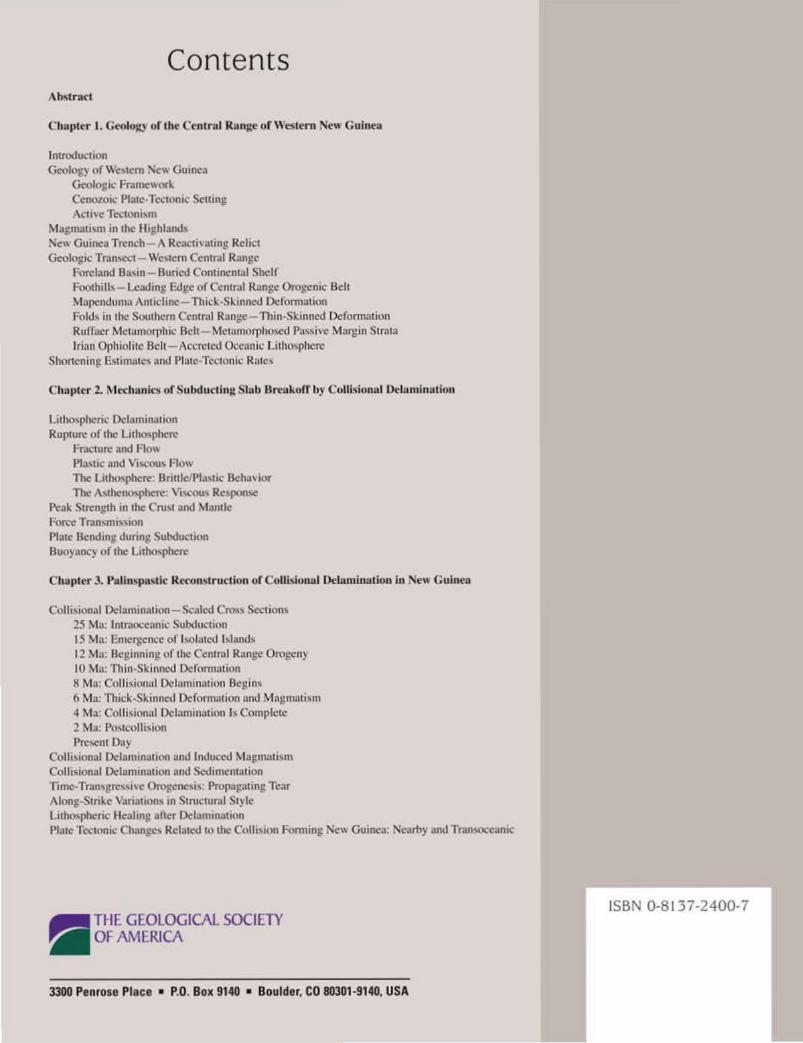
Contents A b.!>lracl
Chapter I. Geol~~ of I he Cen1rol Runge of Western New Guinea
lnlroducaion Geology ot \\e,aem 'loc'' Gumen
Geologu: Fro.~rnc,~orl Ccno1oi\.' Pl.uc-Tc..:tonrc Scurn~ \ 1:11\ c TeliOill\111
Magm:u"m rn lhc lhghlund' 'lei\ Gurm:.1 Trench A Rc.K:II\illing Rc:licl Gcolot!ic Tr.tn,l"CI \\c,lcm Ccnlral Rilnt:c
Foreland Bu"n Buried Con1inental Shell FuoahiiJ,- l..cat.lrng Edge of Ccmntl R;mge Orogenic Bell M~lll'!ndum<~ Anuchnc Th1cl..· Sl..mncd Dcformauon Fold~ rn the Southern Cen1rol Runge - Thin-Skinned Deformmion Rufi,Lcr Metumurrhrc Bch Me~amurpll<>~d P:L,~lve Margin S1n11u lrtclll OJ)hr<llitc fldt A.:crct~.-'\1 0~-cunic l .i ll)u-,phc~
Shoncnlnp E~ummc~ and Pl~tc Tectonic Rtth:~
Chnpttr 2. Mt-chunrc..., or Subducling Slah Breakoff by Collisional Dellimhtalion
Lilho,phenc Dclaminatron Rup1ure of the l.ithu'phere
Fnn.:lllrc ;md Fhn' Pl.l,IIC and Vio,cou~ nm\ The Lilho,phere Bnule I,Ja.,tic Beha' ror The \'thcnu,phere Vi..cuu' Re,pon'e
Pc<lk S1rcngth in the Cru'l .md \Iande Fon:c Tr.tn,mi,\ion Plate BenJrng dunng Suhduc1ion Buo}anq of 1hc Lllhthphcr~
Cbupter 3. Poliru.pru.tlc Rl'Con, truction of Collbional Delaminudon in 'ew Guinea
Colli'il)lllll O.:lamrnalmn - Sc;Jied Cn"' Secuon' 25 Ma: lmrucx:canu: Subduction 15 Ma~ Emer~.tcncc of l,olmcd !\lund<, 12 Mw Bcg,annrng uf the Ccnu,tl Range Orugt:n}
I() M01: Thin-Sklnnc!d Dcfclnmuion 8 Mtl: Colli'lonal Dclnmin.uion Bellin' 6 ~Ia: Thick-SI.innet.l Ddormatiun unu Mul:!m:tli~m -4 ~b: C(llii,ional O.!l.rmin.Ltion ' ' Cumplele 2 Mu. Po,tcolll,ion Pre,cnl Day
Cnlli~ional Dcltunrnalion und lnduL-cd Mapmmi'm Colh,ionul 0\:l:.rmrn:uron und Sedimem.nion 1imc-Tmn,prc''>l\C OroJ!CIIC'" Propaj!.ltmp Tear Along·Stnl.e \iirialion' in Structuml Sl) le Ltlho..pht:nc llc:ahng a her Otlamin;uwn Plutc T~.-'1:tonic Ch.mgc' Rclat\.'tllo the CoJIJ,Jon f-orming New Gulllca: :-.!carl>) Wld Tr..tn'>()Ccunic
8 THE GEOLOGICAL SOCIETY - OF AMERICA
3300 Penrose Place • P.O. Box 9140 • Boulder, CO 80301·9140, USA
ISBN 0·8137-2400-7


![Paleoproterozoic Supercontinent: Origin and Evolution of … · 2019. 3. 13. · GEOTECTONICS Vol. 41 No. 4 2007 PALEOPROTEROZOIC SUPERCONTINENT 259 [42, 45, 111]. The gabbroanorthosite](https://img.pdfslide.us/doc/110x75/60d8b057492df374e2382b3a/paleoproterozoic-supercontinent-origin-and-evolution-of-2019-3-13-geotectonics.jpg)


![Chemical composition of sediments subducting at the Izu ...composition of sediments subducting at the Izu trench. This study is a companion to Kelley et al. [2003], which uses Leg](https://img.pdfslide.us/doc/110x75/60eb377ada598312520373ca/chemical-composition-of-sediments-subducting-at-the-izu-composition-of-sediments.jpg)