Embed Size (px)
Citation preview
SHARE - Sustainable Hydropower in Alpine Rivers Ecosystems http://www.sharealpinerivers.eu
Project reference number: 5-2-3-IT Priority 3 – Environment and Risk Prevention Project duration: 36 months – 1/08/2009 – 31/07/2012
Hydro power plant Bodendorf Pilot case study area of PP6 (TUG)
10/10/2011 version 2.0
Authors Clemens DORFMANN, Josef SCHNEIDER, Christopher SCHREIBER
Member number and name PP6 - TUG
Hydro Power Plant Bodendorf
October 2011 www.share-alpinerivers.eu 2 / 15
Summary
SHORT DESCRIPTION This document intends to give a detailed overview about the PCS area at the run-of-river plant Bodendorf.
Document Control
Project SHARE - Sustainable Hydropower in Alpine Rivers Ecosystems (ref. 5-2-3-IT)
Action WP7 – action 27
Deliverable YES: WP7-27
Due date
Delivery date
Dissemination Restricted
Origin PP6 – TUG
Author Clemens DORFMANN, Christopher SCHREIBER, Josef SCHNEIDER
VERSION DATE AUTHOR AUTHOR’S
ORGANIZATION DESCRIPTION/CHANGES
v01.00 1st version
V02.00 2nd
version
The information contained in this report is subject to change without notice and should not be construed as a commitment by any members of the Share Consortium. The Share Consortium assumes no responsibility for the use or inability to use any procedure, protocol, software or algorithms which might be described in this report. The information is provided without any warranty of any kind and the Share Consortium expressly disclaims all implied warranties, including but not limited to the implied warranties of merchantability and fitness for a particular use.
The responsibility for the content of this publication lies with the authors; it does not necessarily reflect the opinion of the European Community. The European Regional Development Fund is not responsible for any use that may be made of the information contained herein. The information contained is given for information purposes only and does not legally bind any of the parties involved.

Hydro Power Plant Bodendorf
October 2011 www.share-alpinerivers.eu 3 / 15
Table of contents
Index ........................................................................................................................................... 4
Introduction ...................................................................................................................................... 4 1. Pilot case study area ................................................................................................................. 4
1.1 Basin characteristics 4 1.2 Geolithological and land cover characterisation 5 1.3 Hydrological characterisation 6 1.4 River quality 7
2. Plans and management programs .......................................................................................... 10 2.1 Existing management plans and application rules 10 2.2 Monitoring programs 11
3. Water uses .............................................................................................................................. 14 3.1 Hydropower exploitation 14 3.2 Fishery 15 3.3 Farming 15 3.4 Factory 15 3.5 Waste discharges 15 3.6 Drinking water 15 3.7 Touristic fruition 15
4. Pressures and impacts related to water uses ......................................................................... 15 5. Restoration and mitigation actions ........................................................................................ 15
Hydro Power Plant Bodendorf
October 2011 www.share-alpinerivers.eu 4 / 15
Index
Introduction This document describes the Pilot case study (PCS) area of project Partner 6 (TUG), the hydro power plant (HPP) Bodendorf. The HPP Bodendorf is heavily affected by sedimentation of its reservoir. The mean annual sediment input amounts to 53.000 m³, which is approximately 17% of the original reservoir volume (ALPRESERV Vol.5, 2008). Since 1996 the operator performs irregularly reservoir flushings to minimize the negative economic effects of sediment input. The very sensitive ecological situation of the upper river Mur made it necessary to monitor and restrict these flushing events. Within the Interreg IIIB project ALPRESERV a flushing strategy was developed which defines the boundary conditions under which flushing events can be started and performed. For the ALPRESERV project a substantial amount of data was collected which can be considered as a very important basic for the SHARE project. Additionally to these, new data will be collected during future flushing events.
1. Pilot case study area
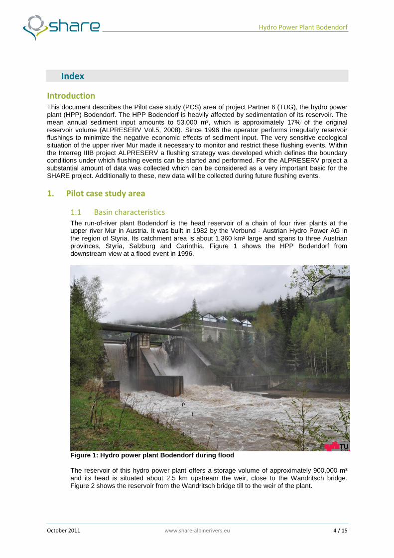
1.1 Basin characteristics The run-of-river plant Bodendorf is the head reservoir of a chain of four river plants at the upper river Mur in Austria. It was built in 1982 by the Verbund - Austrian Hydro Power AG in the region of Styria. Its catchment area is about 1,360 km² large and spans to three Austrian provinces, Styria, Salzburg and Carinthia. Figure 1 shows the HPP Bodendorf from downstream view at a flood event in 1996.
Figure 1: Hydro power plant Bodendorf during flood
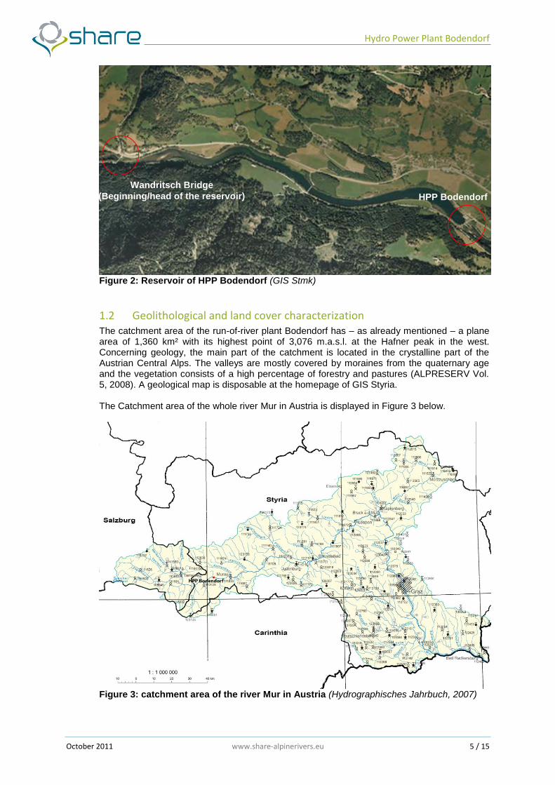
The reservoir of this hydro power plant offers a storage volume of approximately 900,000 m³ and its head is situated about 2.5 km upstream the weir, close to the Wandritsch bridge. Figure 2 shows the reservoir from the Wandritsch bridge till to the weir of the plant.
Hydro Power Plant Bodendorf
October 2011 www.share-alpinerivers.eu 5 / 15
Figure 2: Reservoir of HPP Bodendorf (GIS Stmk)
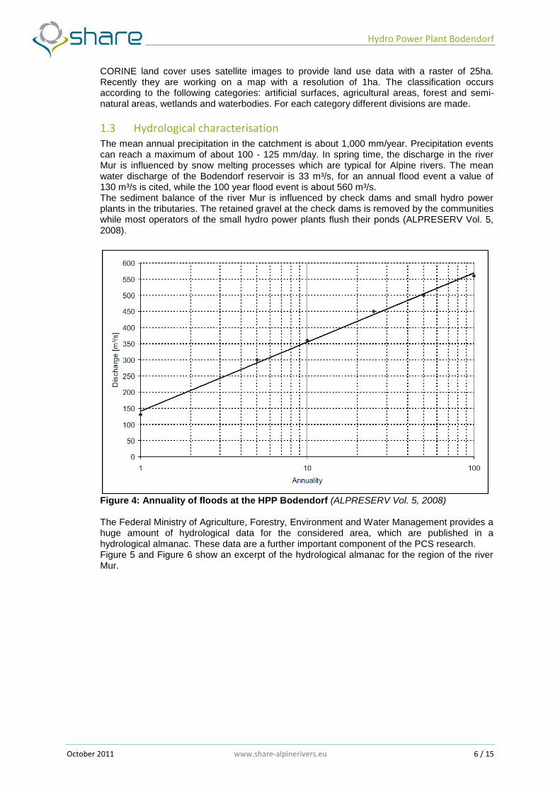
1.2 Geolithological and land cover characterization The catchment area of the run-of-river plant Bodendorf has – as already mentioned – a plane area of 1,360 km² with its highest point of 3,076 m.a.s.l. at the Hafner peak in the west. Concerning geology, the main part of the catchment is located in the crystalline part of the Austrian Central Alps. The valleys are mostly covered by moraines from the quaternary age and the vegetation consists of a high percentage of forestry and pastures (ALPRESERV Vol. 5, 2008). A geological map is disposable at the homepage of GIS Styria. The Catchment area of the whole river Mur in Austria is displayed in Figure 3 below.
Figure 3: catchment area of the river Mur in Austria (Hydrographisches Jahrbuch, 2007)
HPP Bodendorf
Wandritsch Bridge
(Beginning/head of the reservoir)
Hydro Power Plant Bodendorf
October 2011 www.share-alpinerivers.eu 6 / 15
CORINE land cover uses satellite images to provide land use data with a raster of 25ha. Recently they are working on a map with a resolution of 1ha. The classification occurs according to the following categories: artificial surfaces, agricultural areas, forest and semi-natural areas, wetlands and waterbodies. For each category different divisions are made.
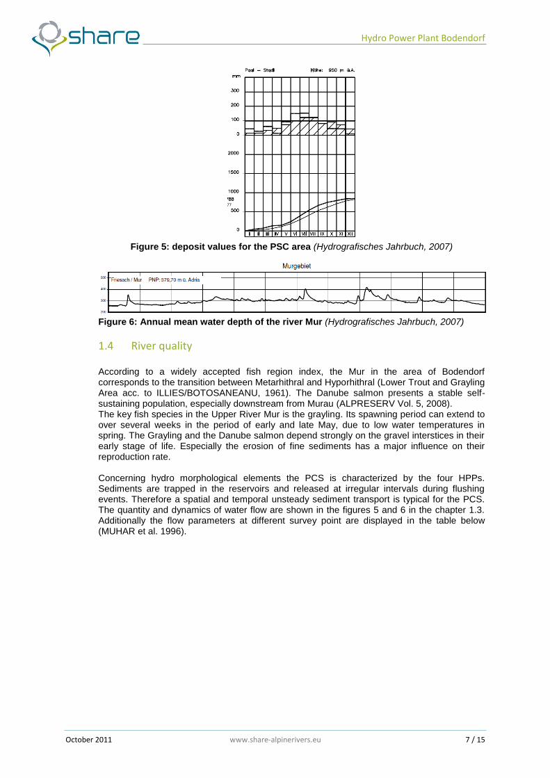
1.3 Hydrological characterisation The mean annual precipitation in the catchment is about 1,000 mm/year. Precipitation events can reach a maximum of about 100 - 125 mm/day. In spring time, the discharge in the river Mur is influenced by snow melting processes which are typical for Alpine rivers. The mean water discharge of the Bodendorf reservoir is 33 m³/s, for an annual flood event a value of 130 m³/s is cited, while the 100 year flood event is about 560 m³/s. The sediment balance of the river Mur is influenced by check dams and small hydro power plants in the tributaries. The retained gravel at the check dams is removed by the communities while most operators of the small hydro power plants flush their ponds (ALPRESERV Vol. 5, 2008).
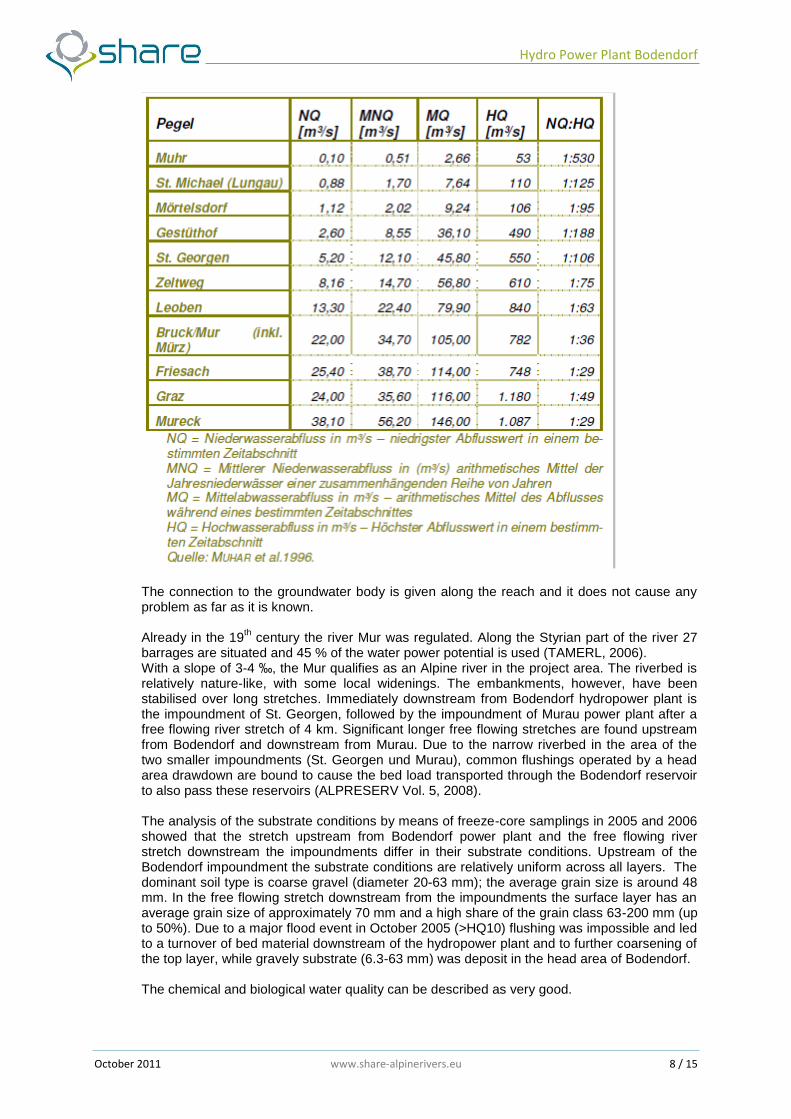
Figure 4: Annuality of floods at the HPP Bodendorf (ALPRESERV Vol. 5, 2008) The Federal Ministry of Agriculture, Forestry, Environment and Water Management provides a huge amount of hydrological data for the considered area, which are published in a hydrological almanac. These data are a further important component of the PCS research. Figure 5 and Figure 6 show an excerpt of the hydrological almanac for the region of the river Mur.
Hydro Power Plant Bodendorf
October 2011 www.share-alpinerivers.eu 7 / 15
Figure 5: deposit values for the PSC area (Hydrografisches Jahrbuch, 2007)
Figure 6: Annual mean water depth of the river Mur (Hydrografisches Jahrbuch, 2007)
1.4 River quality
According to a widely accepted fish region index, the Mur in the area of Bodendorf corresponds to the transition between Metarhithral and Hyporhithral (Lower Trout and Grayling Area acc. to ILLIES/BOTOSANEANU, 1961). The Danube salmon presents a stable self-sustaining population, especially downstream from Murau (ALPRESERV Vol. 5, 2008). The key fish species in the Upper River Mur is the grayling. Its spawning period can extend to over several weeks in the period of early and late May, due to low water temperatures in spring. The Grayling and the Danube salmon depend strongly on the gravel interstices in their early stage of life. Especially the erosion of fine sediments has a major influence on their reproduction rate. Concerning hydro morphological elements the PCS is characterized by the four HPPs. Sediments are trapped in the reservoirs and released at irregular intervals during flushing events. Therefore a spatial and temporal unsteady sediment transport is typical for the PCS. The quantity and dynamics of water flow are shown in the figures 5 and 6 in the chapter 1.3. Additionally the flow parameters at different survey point are displayed in the table below (MUHAR et al. 1996).
Hydro Power Plant Bodendorf
October 2011 www.share-alpinerivers.eu 8 / 15
The connection to the groundwater body is given along the reach and it does not cause any problem as far as it is known. Already in the 19
th century the river Mur was regulated. Along the Styrian part of the river 27
barrages are situated and 45 % of the water power potential is used (TAMERL, 2006). With a slope of 3-4 ‰, the Mur qualifies as an Alpine river in the project area. The riverbed is relatively nature-like, with some local widenings. The embankments, however, have been stabilised over long stretches. Immediately downstream from Bodendorf hydropower plant is the impoundment of St. Georgen, followed by the impoundment of Murau power plant after a free flowing river stretch of 4 km. Significant longer free flowing stretches are found upstream from Bodendorf and downstream from Murau. Due to the narrow riverbed in the area of the two smaller impoundments (St. Georgen und Murau), common flushings operated by a head area drawdown are bound to cause the bed load transported through the Bodendorf reservoir to also pass these reservoirs (ALPRESERV Vol. 5, 2008). The analysis of the substrate conditions by means of freeze-core samplings in 2005 and 2006 showed that the stretch upstream from Bodendorf power plant and the free flowing river stretch downstream the impoundments differ in their substrate conditions. Upstream of the Bodendorf impoundment the substrate conditions are relatively uniform across all layers. The dominant soil type is coarse gravel (diameter 20-63 mm); the average grain size is around 48 mm. In the free flowing stretch downstream from the impoundments the surface layer has an average grain size of approximately 70 mm and a high share of the grain class 63-200 mm (up to 50%). Due to a major flood event in October 2005 (>HQ10) flushing was impossible and led to a turnover of bed material downstream of the hydropower plant and to further coarsening of the top layer, while gravely substrate (6.3-63 mm) was deposit in the head area of Bodendorf.
The chemical and biological water quality can be described as very good.
Hydro Power Plant Bodendorf
October 2011 www.share-alpinerivers.eu 9 / 15
The impact on fauna and flora in the PCS is mainly given by morphological deficits and suspended sediment concentration during flushing events. To evaluate the impact of flood events and the flushing of the reservoir on the fish fauna, regular surveys of fish larvae and juvenile fish fauna were performed along selected gravel bars in 2005 and 2006 and the results were compared with the monitoring of the fish stocks from 1999 to 2006. It was shown that the floods have a bigger impact on the newly hatched larvae than on older life-stages. In the case of the grayling in the Upper River Mur this means that floods lead to a substantial reduction of the larvae population, especially in June and July. In addition, there is no documentable influence of floods on the nutritional situation of larvae/juvenile fish (ALPRESERV Vol. 5, 2008).
Hydro Power Plant Bodendorf
October 2011 www.share-alpinerivers.eu 10 / 15
2. Plans and management programs The reservoir of the HPP Bodendorf is heavily affected by sediment deposition. The operation of the power plant is dominated by its flushing strategy in combination with a continuous monitoring system.
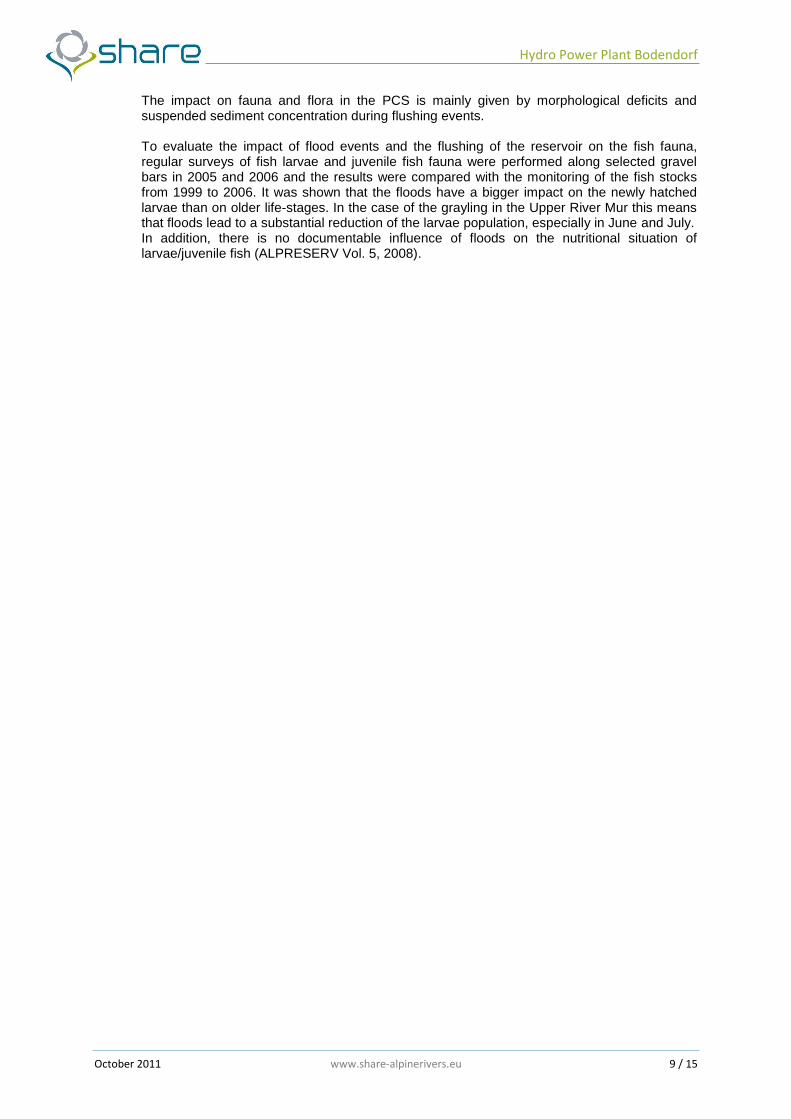
2.1 Existing management plans and application rules As already mentioned in the introduction, the reservoir of the HPP Bodendorf is heavily affected by sedimentation. So the operator has to flush the reservoir regularly. In order to avert negative impacts to the ecosystem of the river Mur, a flushing strategy was developed within the Interreg IIIB project ALPRESERV. This concept consists of two main parts. In the first part, the conditions under which a flushing event can be started are defined, whereas the second part describes the optimal coordination among the four HPPs concerning discharge, velocity or the temporally delay of the flushing start. Furthermore the flushing concept was an important input for the flushing permission of this HPP chain, which is valid from 2007 till open. In Table 1 the legal starting conditions of a flushing event depending on seasonal issues and discharge values can be seen.
Table 1: Legal starting conditions of a flushing event (ALPRESERV Vol. 5, 2008)
The study showed that long flushing periods result in a higher concentration of suspended load, which has a negative impact on the rivers ecological system. This led to a recommendation of a 1-2 year flushing period and a year-round flushing at floods >HQ5 to prevent massive sedimentation at the beginning of the backwater. For the extraction of the sediment load after two years of operation a discharge from 180m²/s for the duration of 2 days is needed for flushing. (Optimierte Entlandsungsmassnahmen an alpinen Speichern, Knoblauch) The research that led to this flushing strategy showed that the impact of natural floods and flushing events on the juvenile fish fauna depends heavily on the season and the developmental stage of the larvae and/or juveniles (ALPRESERV Vol. 5, 2008). The best season in order to prevent a high ecological impact would be the late summer from August to September. Every year without a flushing promotes fish reproduction and therefore helps stabilize the grayling, Danube salmon and brown trout populations. Accordingly, in subsequent years the ecological priority decreases and the sediment management priority increases. The ongoing sedimentation in the reservoirs increases the pressure to empty them. Therefore, the time slot for flushing is extended to include the spring months of April and May. Ultimately, if several years pass without a flushing, then flushing is allowed from April until late September (ALPRESERV Vol. 5, 2008).
Hydro Power Plant Bodendorf
October 2011 www.share-alpinerivers.eu 11 / 15
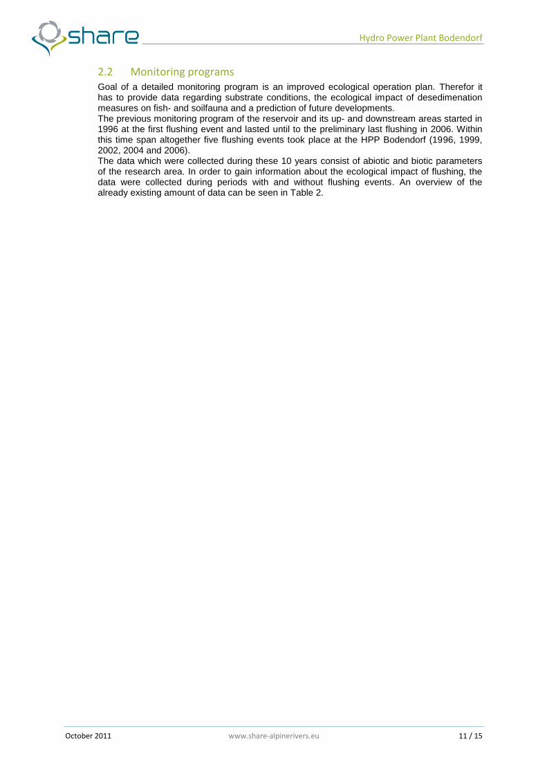
2.2 Monitoring programs Goal of a detailed monitoring program is an improved ecological operation plan. Therefor it has to provide data regarding substrate conditions, the ecological impact of desedimenation measures on fish- and soilfauna and a prediction of future developments. The previous monitoring program of the reservoir and its up- and downstream areas started in 1996 at the first flushing event and lasted until to the preliminary last flushing in 2006. Within this time span altogether five flushing events took place at the HPP Bodendorf (1996, 1999, 2002, 2004 and 2006). The data which were collected during these 10 years consist of abiotic and biotic parameters of the research area. In order to gain information about the ecological impact of flushing, the data were collected during periods with and without flushing events. An overview of the already existing amount of data can be seen in Table 2.
Hydro Power Plant Bodendorf
October 2011 www.share-alpinerivers.eu 12 / 15
Table 2: Available data of the PSC area
AAvvaalliiaabbllee ddaattaa rruunn--ooff--rriivveerr ppllaanntt BBooddeennddoorrff
TTYYPPOOLLOOGGYY NNAAMMEE DDAATTAA PPRROOPPEERRTTYY TTIIMMEE CCOOVVEERRIINNGG SSAAMMPPLLIINNGG FFRREEQQUUEENNCCYY
RIVER ECOSYSTEM
Grain size distribution of the reservoir Bodendorf
and its up- and downstream areas
TUG 2006,2008 -
Suspended sediment measurements at flushing
events TUG 1996, 1999, 2002, 2004, 2006 at flushing events
Bed load transport measurements
TUG
single measurement
Digital Terrain Models TUG 1994 - 2002 yearly
Mass balances of flushings
TUG 1996, 1999, 2002, 2004, 2006 at flushing events
Substrate conditions
(abiotic, biotic conditions) TUG 2005, 2006 at flushing events
Vibert-Boxes TUG 2008 single measurement
Juvenile fish and fish larvae surveys
TUG 2005, 2006 around flood events
Adult fish surver TUG -2010 yearly
Flushing Strategy TUG 2007 single paper
Gauging stations Hydrographischer
Dienst in Österreich
-2007 constantly
Habitat mapping TUG 2008 single mapping
Precipitation amount measurements
Hydrographischer Dienst in
Österreich -2007 constantly
ENERGY PRODUCTION
Annual Power Produces AHP -2010 yearly
Linear Annual Power Produces
AHP -2010 yearly
Power Installed AHP -2010 -
Energy Production Lack AHP -2010 yearly
Annual Energy Production
AHP -2010 yearly
LEGAL ASPECTS
Flushing permission AHP 1998, 2007 two permissions
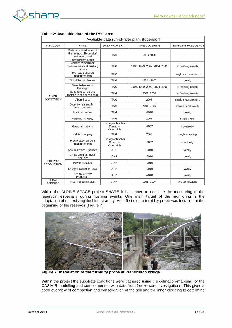
Within the ALPINE SPACE project SHARE it is planned to continue the monitoring of the reservoir, especially during flushing events. One main target of the monitoring is the adaptation of the existing flushing strategy. As a first step a turbidity probe was installed at the beginning of the reservoir (Figure 7).
Figure 7: Installation of the turbidity probe at Wandritsch bridge Within the project the substrate conditions were gathered using the colmation-mapping for the CASiMiR modelling and complemented with data from freeze-core investigations. This gives a good overview of compaction and consolidation of the soil and the inner clogging to determine
Hydro Power Plant Bodendorf
October 2011 www.share-alpinerivers.eu 13 / 15
the impact of altered substrate conditions on the fauna. The influence of flushing on the amount of suspended load was investigated with “sediment-traps” (modified Vibert-boxes). The boxes were also used to gather information about the spawing behaviour and places of fishes. Together with speriodic larvae-fishing and survey of fish population the fish-ecological investigations are necessary to provide information about the impact of flushing on the different life-stages. To estimate the long-term development a compination of habitat model and morphodynamic model (MIKE 21C) was used. (ALPRESERVE Vol. 6, 2008)
Hydro Power Plant Bodendorf
October 2011 www.share-alpinerivers.eu 14 / 15
3. Water uses The water uses at the basin of HPP Bodendorf are limited to hydropower exploitation and fishery, besides some touristic impact. Other kinds of water use, like gaining drinking water or irrigation of farm land are not existing in this area due to its Alpine character (large deposit rate, steep slopes, extensive farming).
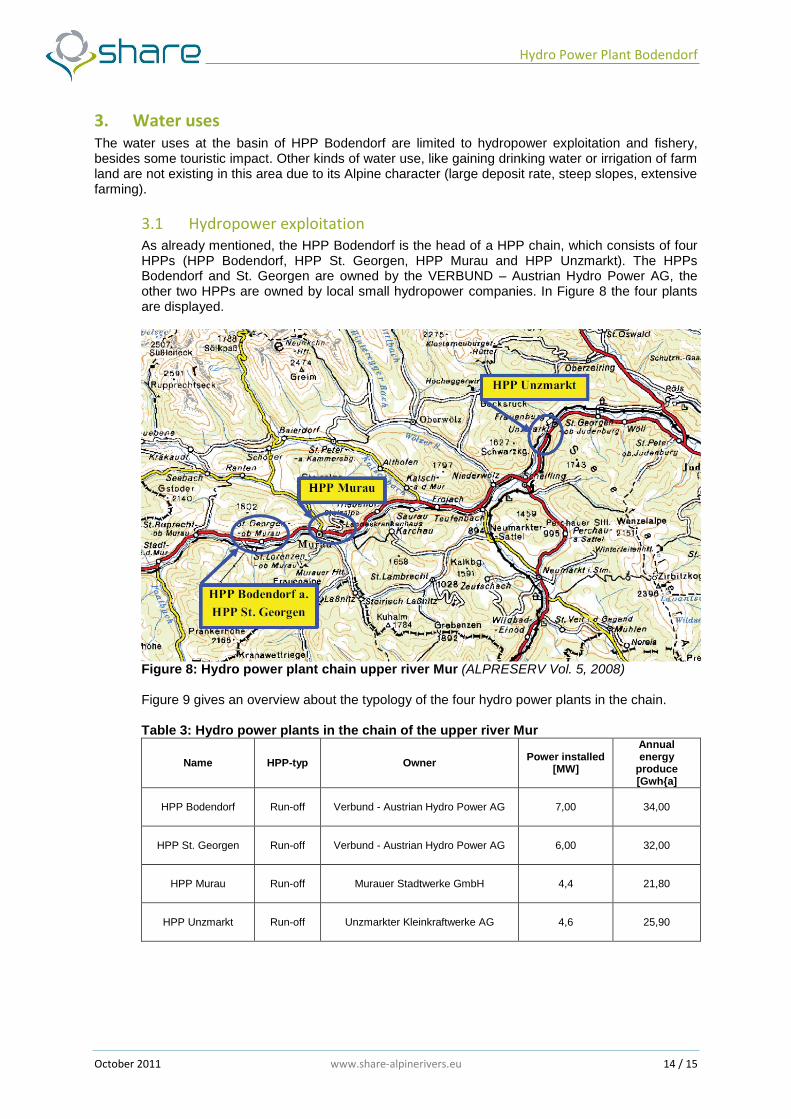
3.1 Hydropower exploitation As already mentioned, the HPP Bodendorf is the head of a HPP chain, which consists of four HPPs (HPP Bodendorf, HPP St. Georgen, HPP Murau and HPP Unzmarkt). The HPPs Bodendorf and St. Georgen are owned by the VERBUND – Austrian Hydro Power AG, the other two HPPs are owned by local small hydropower companies. In Figure 8 the four plants are displayed.
Figure 8: Hydro power plant chain upper river Mur (ALPRESERV Vol. 5, 2008) Figure 9 gives an overview about the typology of the four hydro power plants in the chain. Table 3: Hydro power plants in the chain of the upper river Mur
Name HPP-typ Owner Power installed
[MW]
Annual energy
produce [Gwh{a]
HPP Bodendorf Run-off Verbund - Austrian Hydro Power AG 7,00 34,00
HPP St. Georgen Run-off Verbund - Austrian Hydro Power AG 6,00 32,00
HPP Murau Run-off Murauer Stadtwerke GmbH 4,4 21,80
HPP Unzmarkt Run-off Unzmarkter Kleinkraftwerke AG 4,6 25,90
Hydro Power Plant Bodendorf
October 2011 www.share-alpinerivers.eu 15 / 15
3.2 Fishery Fishery is a leisure activity and no profession in most cases, which is a typical situation for Austrian Alpine rivers. The reservoirs as well as the free-flowing stretches are used by the fishery. However, there are no fish bypasses existing and therefore the migration of fish in the upper Mur region is restricted.
3.3 Farming Not relevant in the PCS area.
3.4 Factory Not relevant in the PCS area.
3.5 Waste discharges Not relevant in the PCS area.
3.6 Drinking water Not relevant in the PCS area.
3.7 Touristic fruition A road which is located directly beside the reservoir is used for walking and cycling. The view, the atmosphere adjacent and the existing bird and animal fauna besides the flora are very attractive for tourists.
4. Pressures and impacts related to water uses The deposition of sediments leads to an aggravation for the operator of the reservoirs. This might be an economic as well as an operational impact. Flushing events imply economic losses during the procedure on one hand and bring economic benefits due to the recovery of storage volume on the other hand. For the fishery the negative impact of suspended sediments during the flushing is apparently. Moreover, the clogging of gravel bars lead to a reduction of reproduction habitat. Flushing events are in most cases not very attractive for touristic purposes.
5. Restoration and mitigation actions The flushing of a reservoir is in most cases a big ecological impact for the habitat. Nevertheless, for operational and maybe even for security reasons reservoirs have to be flushed. A flushing permission for the HPP chain at the upper Mur exists. The mitigation action for the PCS is a verification of the existing permission and an optimisation of flushing events and an improvement of the ecological situation downstream of the reservoirs. The adapted flushing strategy must not worsen the flood security.