Embed Size (px)
Citation preview

HURRICANE HEAT POTENTIAL ESTIMATES FROM SATELLITE
RADAR ALTIMETRY
Lynn K. Shay
Goal: To understand the role of deep warm ocean mixed layers on heat potential estimates relative to hurricane intensity change.
Research support by NSF and NOAA.
COLLABORATORS:
Peter Black, Mike Black, S. Daniel Jacob, Tom Cook, Michelle Mainelli, Sean White, Eric
Uhlhorn, Jim Caswell, Ed Walsh, Bob Cheney, Mark DeMaria, Gustavo Goni
Special thanks to NOAA’s Laboratory for Satellite Altimetry, NOAA TPC, NOAA HRD and AOC who maintain the research aircraft.

BRET (1999):

INTRODUCTION:
• During strong forcing events, SSTs mix with OML.
• Depth of 26oC water deeper in the main ocean features of the gyres.
• Heat content relative to 26oC better indicator for possible TC intensity change (Leipper, 70).
• Discussion focuses on Loop Current Warm Core Ring characteristics and impact on hurricanes.
• Measurements required to evaluate remote sensors (radar altimeters) and oceanic and coupled models.
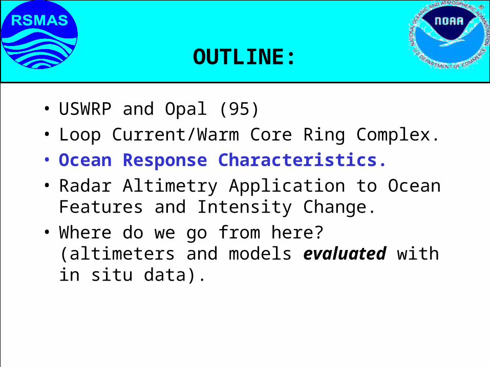
OUTLINE:
• USWRP and Opal (95)• Loop Current/Warm Core Ring Complex.• Ocean Response Characteristics.• Radar Altimetry Application to Ocean Features
and Intensity Change.• Where do we go from here? (altimeters and
models evaluated with in situ data).

IS SST REALLY ENOUGH?DeMaria and Kaplan (94)
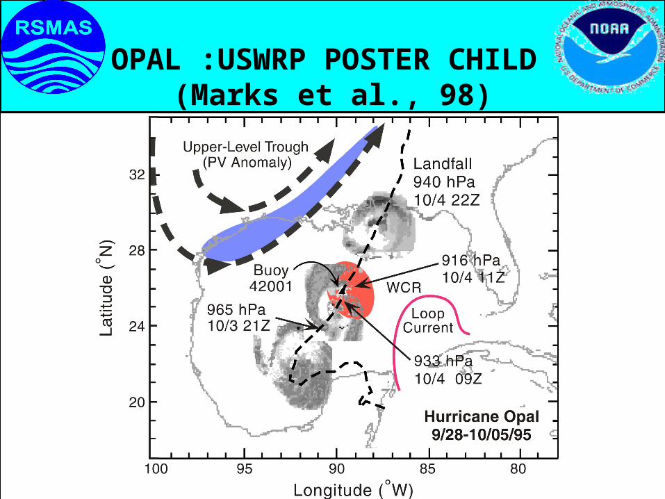
OPAL :USWRP POSTER CHILD (Marks et al., 98)
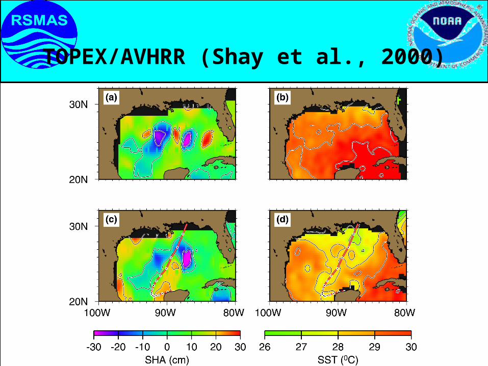
TOPEX/AVHRR (Shay et al., 2000)

LOOP CURRENT-WARM CORE RING COMPLEX:
• Summer 1999;2000: NOAA WP-3D Flights over regime.
• Aircraft-based measurements using AXCTD/AXCP/AXBT over synoptic scales.
• Radar altimetry better indicator of warm water (positive SHA ~ 35 cm).
• Heat Content: 130 KJ cm-2
• d20 > 250 m, d26 >120 m.
• Deeper ocean profiling needed to resolve current structures.

CONCEPTUAL PICTURE:

MICOM SIMULATION: Courtesy of R. Bleck

AXCTD PROFILES (EDDY AND GULF)

AUG 1999: SNAPSHOT

LOOPCURRENT
CROSSSECTIONS:
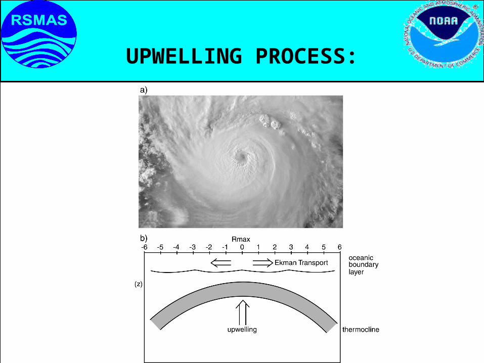
UPWELLING PROCESS:
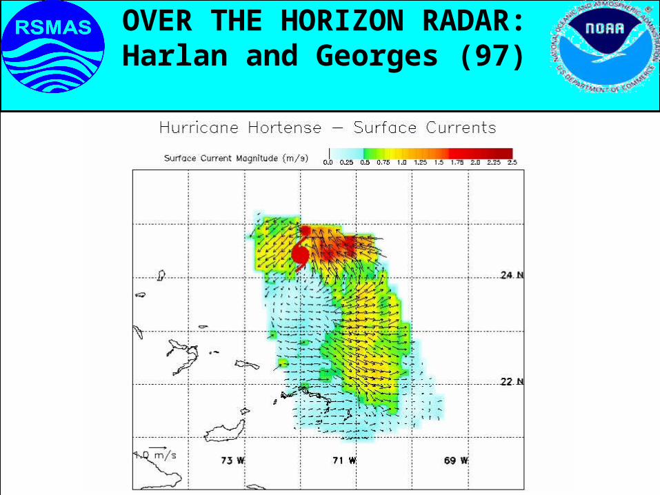
OVER THE HORIZON RADAR:Harlan and Georges (97)

AXCP GRID FROM GILBERT’S WAKE(Shay et al., 92, 98)

HEAT POTENTIAL: Leipper and Volgenau (72)
Q x y t c Tdz
T
c
H p
p
( , , )
,
,
where:
is the density structure (T,S)
is the temperature difference relative to 26 C
is specific heat capacity of sea water.
• Heat Potential

OBJECTIVE ANALYSISOBJECTIVE ANALYSIS
Barnes (1964)
• Represents a 2-D atmos variable by Fourier integral.
• Two critical parameters: d (e-fold distance) & R (radius of influence).
Compared OA for blended SHA fields from altimeters TOPEX/ERS-2 (Mainelli-Huber 2000).
Mariano and Brown (1992) • Decomposes a scalar observation into 3 components.• Least squares fit to each var.& apply an OA technique.• Final est. sum of trend field and the objectively mapped deviation field.

TOPEX/ERS2 ANALYSIS:
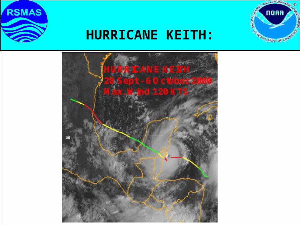
HURRICANE KEITH:
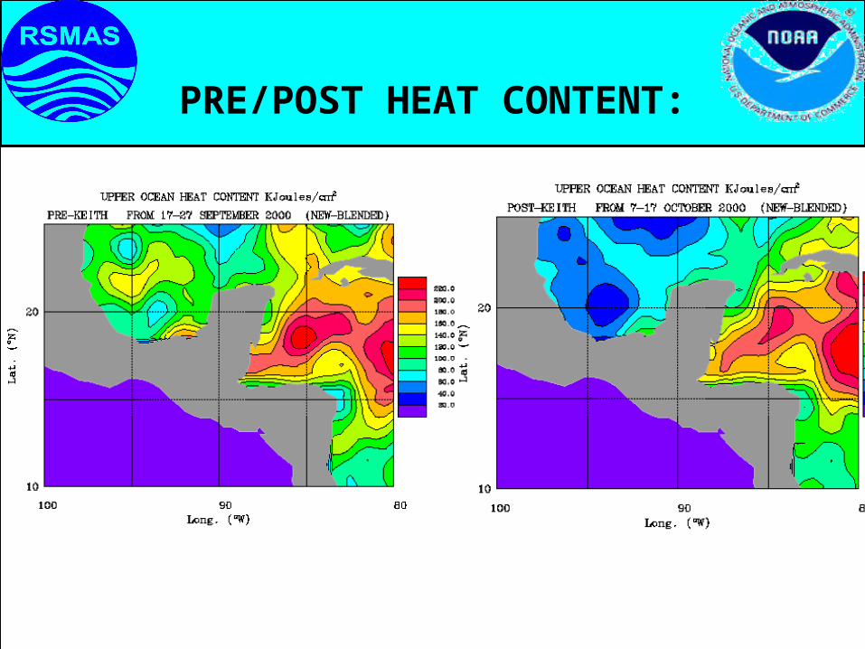
PRE/POST HEAT CONTENT:
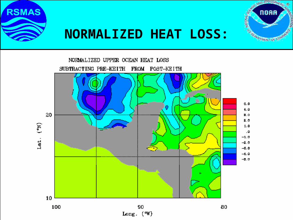
NORMALIZED HEAT LOSS:
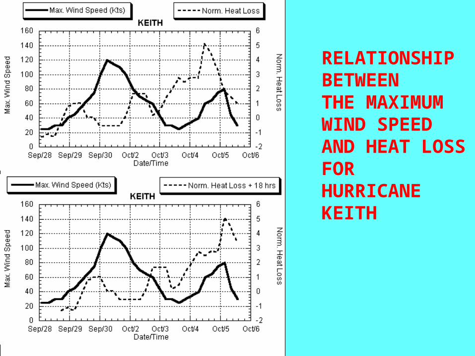
RELATIONSHIP BETWEEN THE MAXIMUM WIND SPEED AND HEAT LOSS FOR HURRICANE KEITH

HEAT POTENTIAL AUGUST 1999

COUPLED OBERVATIONS: A NEW ERA
Experimental programs must acquire measurements in both fluids:
• Surface Wind and Wave Field (SRA,SFMR),• APBL Structure (GPS) ,• Ocean Structure (Floats, AXCP/ AXCTD,
AUVs), and• SHA From TOPEX/ERS-2 and SST Fields.
Required for coupled models (i.e. to examine air-sea parameterization schemes under development).

Two Layer Model
WARMCOLD
l
lThermocline
Sea-surface
gl = 2- 1
2g
1
2
30cm-10cm

MEASUREMENT STRATEGY:
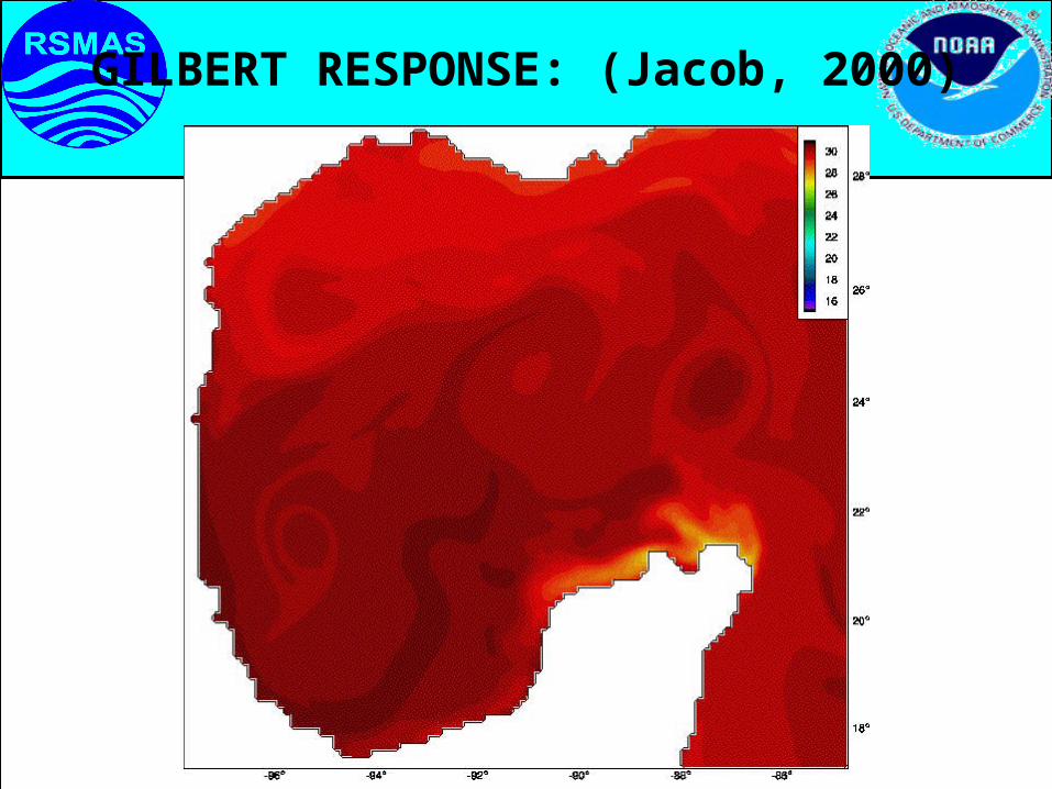
GILBERT RESPONSE: (Jacob, 2000)

OPERATIONAL IMPROVEMENTS:
• TOPEX/ERS-2/ ETC to monitor hurricane heat content Globally (Build a data base).
• Explore different data assimilation schemes to ingest data into oceanic models.
• Evaluate estimates of HC from Floats, etc to improve algorithms.
• Deploy AXBTs/AXCTDs/AXCPs during Recon flights.
• Relate atmospheric data (GPS) to heat content variability and its change.
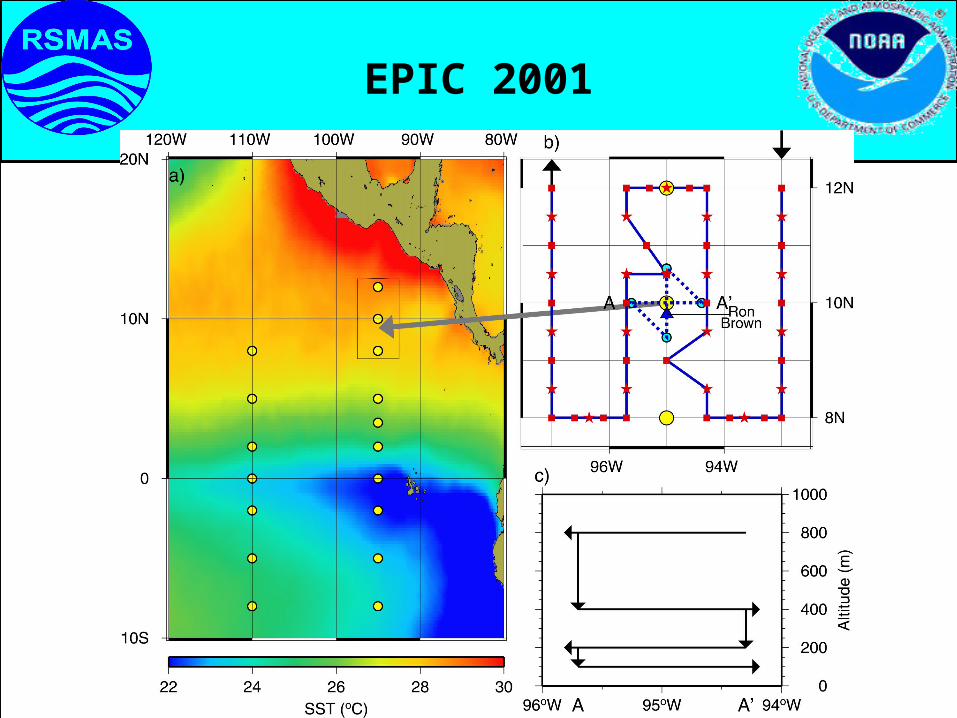
EPIC 2001
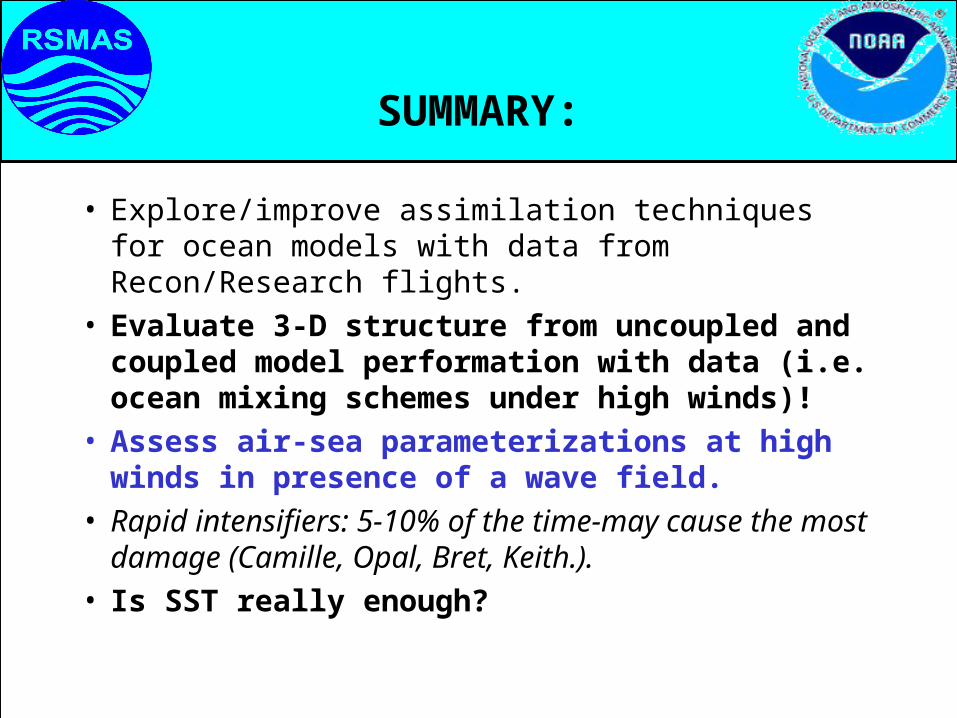
SUMMARY:
• Explore/improve assimilation techniques for ocean models with data from Recon/Research flights.
• Evaluate 3-D structure from uncoupled and coupled model performation with data (i.e. ocean mixing schemes under high winds)!
• Assess air-sea parameterizations at high winds in presence of a wave field.
• Rapid intensifiers: 5-10% of the time-may cause the most damage (Camille, Opal, Bret, Keith.).
• Is SST really enough?