Embed Size (px)
Citation preview
Howe Landscape Unit
Sustainable Resource Management Plan
Ministry of Forests, Lands and Natural Resource Operations
South Coast Region
2012

Howe LU SRMP 2012
i
Sustainable Resource Management Plan: Howe Landscape Unit
Acknowledgements
The Ministry of Forests, Lands and Natural Resource Operations recognises the following participants and contributors, without which the completion of this Sustainable Resource Management Plan would not have been possible:
Smart Forest Planning Consulting: Brian Smart, RPF, RPBio
Pollock Forest Management Ltd.: Tania Pollock, RPF
BC Timber Sales: Rob Martin, RPF
Province of British Columbia: Greg George, RPBio; Chuck Anderson, RPF; Peter Verschoor, RPF; Frank DeGagne, RPF; Lew Greentree; Blake Fougere, RPF
Howe LU SRMP 2012
ii
Table of Contents
1.0 Introduction ................................................................................................. 3 2.0 Howe Landscape Unit Description ..................................................... 4
2.1 Biophysical .............................................................................................................................. 4 2.2 Summary of Land Status........................................................................................................6
3.0 Key Resource Tenures ............................................................................. 7 3.1 Forest Tenures Holders ........................................................................................................... 7 3.2 Mineral Tenure Holders .......................................................................................................... 8
4.0 Significant Resource Values .................................................................. 8 4.1 Fish, Wildlife and Biodiversity ................................................................................................ 8 4.2 Timber Resources ................................................................................................................... 9 4.4 Recreation ............................................................................................................................... 9 4.4 Mineral Resource Values ...................................................................................................... 10 4.5 Water Quality ....................................................................................................................... 10
5.0 First Nations .............................................................................................. 10
6.0 Strategic Level Plans .............................................................................. 11
7.0 OGMA Planning Methodology ........................................................... 11 7.1 Old Growth Management Areas Selection ........................................................................... 11 7.2 Boundary Mapping ............................................................................................................... 13 7.3 Amendment Policy ............................................................................................................... 13
8.0 OGMA Analysis ......................................................................................... 14
9.0 Landscape Unit Plan Objectives ....................................................... 14
List of Tables
Table 1. Land Status of the Howe Landscape Unit ............................................................... 6 Table 2. Crown forest land base classification and OGMA target within the Howe
Landscape Unit ........................................................................................................ 7 Table 3. Old Seral Representation Achieved ...................................................................... 14
List of Figures
Figure 1. Location of the Howe Landscape Unit ................................................................... 5
List of Appendices
Appendix I OGMA Summary and Rationale – Howe LU.................................................... 15 Appendix II List of Acronyms .............................................................................................. 21 Appendix III Public Consultation Summary ......................................................................... 22
Howe LU SRMP 2012
3
1.0 Introduction This report provides background information used during the preparation of the Landscape Unit Plan for the Howe Landscape Unit (LU) and associated proposed legal objectives. A description of the planning unit, discussion on significant resource values, and an Old Growth Management Area (OGMA) summary and rationale are provided. Appendix I contains the OGMA Summary and Appendix II is a list of acronyms used.
Biological diversity or biodiversity is defined as: ‘the diversity of plants, animals and other living organisms in all their forms and levels of organisation, and includes the diversity of genes, species and ecosystems as well as the evolutionary and functional processes that link them1
’. British Columbia is the most biologically diverse province in Canada.
LU Planning through Section 93.4 of the Land Act for the purposes of the Forest and Range Practices Act (FRPA) allows legal establishment of objectives to address and sustain landscape level biodiversity values. Implementation of this initiative is intended to help maintain certain biodiversity values. Managing for biodiversity through retention of old growth forests is considered important not only for wildlife, but can also provide important benefits to ecosystem management, protection of water quality and preservation of other natural resources. Although not all elements of biodiversity can be, or need be, maintained on every hectare, a broad geographic distribution of old growth ecosystems is intended to help sustain the genetic and functional diversity of native species across their historic ranges. In accordance with the direction of government, the Sunshine Coast Forest District has established draft biodiversity Emphasis Options (BEO) for the 26 Landscape Units in its district. Through the ranking process, the Howe LU was rated as “Intermediate” BEO, which requires that priority biodiversity provisions be undertaken immediately. Development of this report and work to identify OGMAs was completed in collaboration with BC Timber Sales and the Ministry of Forests, Lands & Natural Resource Operations (MFLNRO), with original work completed by Smart Forest Planning Ltd. Funding was provided by the Forest Investment Account. First Nations were consulted and public review from the public was sought during a 60-day public review and comment period (Appendix 3). Supporting documentation regarding government policy, planning processes and biodiversity concepts are provided in the Biodiversity Guidebook, the Landscape Unit Planning Guide2
1 from BC Ministry of Forests and BC Environment. 1995. Biodiversity Guidebook.
, the
2 BC Ministry of Forests and Ministry of Environment. 1999. Landscape Unit Planning Guide. Victoria, BC
Howe LU SRMP 2012
4
Vancouver Forest Region Landscape Unit Planning Strategy3,Sustainable Resource Management Planning: A Landscape-level Strategy for Resource Development4
as well as any strategic plan(s) that may be developed post publication of this document.
The distribution of OGMAs will have to be reviewed periodically to ensure the objectives and ecological suitability are maintained through time. Wildlife management practices and operational procedures will improve as more information and technology is acquired.
2.0 Howe Landscape Unit Description
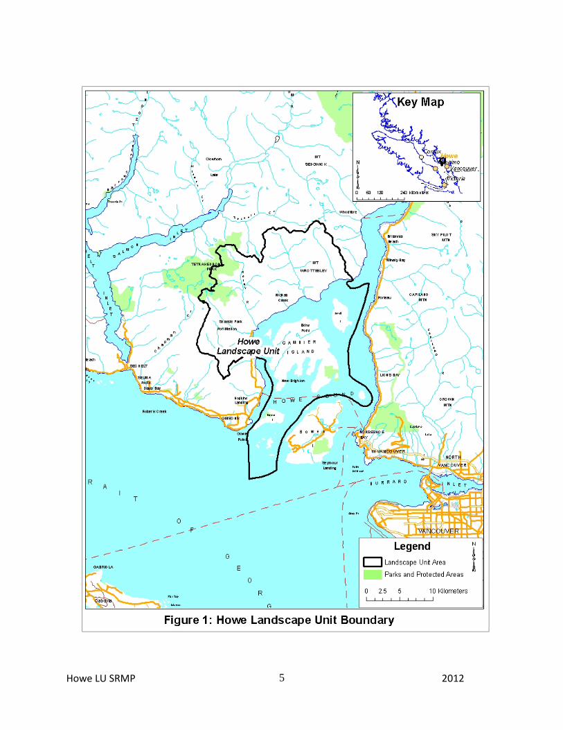
2.1 Biophysical The Howe Landscape Unit encompasses the watersheds that drain into the west side of Howe Sound from Ouillet Creek at the south to Potlatch Creek at the northeast (Figure 1); it also includes Gambier and Anvil Islands. Major watercourses in the Howe LU include Dakota, McNair, McNab, Rainy and Potlatch Rivers. The landscape unit covers a total area of 34,622.4 ha. The Howe LU lies within the Georgia Depression and Coast and Mountains Ecoprovinces, including the Georgia Lowland and Southern Pacific Ranges Ecosections5
.
There are six Biogeoclimatic Ecosystem Classification (BEC) subzones or variants present in the Howe LU, occurring within three natural disturbance types (NDTs). NDT2 includes the CWHdm and the CWHxm1, and NDT1 includes the MHmm1, CWHvm1 and the CWHvm2 (Figure 2). NDT5 is completely comprised of the high-elevation, non-forested Alpine Tundra (AT) zone. Forested stands on lower elevation productive sites (typically on slopes with low to moderate gradient in the CWHvm1, CWHdm and CWHxm1) have been historically disturbed by forest fires and past timber harvesting. Wildfire swept across both Gambier and Anvil Islands and up McNab and Potlatch Creeks in the late 1800’s. An intense fire killed most of the trees in those areas, leaving only remnants of the original old growth forest in the lower elevations. The low representation of old seral forest within these lower to middle elevation BEC subzones/variants and the large amount of maturing timber illustrates this disturbance history.
3 BC Ministry of Forests. 1999. Vancouver Forest Region Landscape Unit Planning Strategy 4 BC Ministry of Agriculture and Lands. 2002. Sustainable Resource Management Planning: A Landscape-level Strategy for Resource Development 5 Demarchi, D. 1996. An introduction to the ecoregions of British Columbia. Wildlife Branch, Ministry of Environment, Lands and Parks, Victoria. Ministry of Sustainable Resource Management. Update March 2004. British Columbia; Ecoregion Ecosystem Classification Units, Ver. 2.01.
Howe LU SRMP 2012
5

Howe LU SRMP 2012
6
2.2 Summary of Land Status
Land status within the Howe LU is summarised in Table 1. Of the total area, 21,819.9 ha (63%) are within the Crown Forested Land Base (CFLB). The remaining 12,786.0 ha (37%) of the landscape unit are classified as non-forested or non-Crown (rock, alpine tundra, water, private land, etc.) and have been excluded from OGMA contributions and calculations. There are 5038 hectares of private land and 11 hectares of Indian Reserve within the Howe landscape unit which has been excluded from the OGMA selection process. Provincial park land, located on the mainland (Tetrahedron Park) and Gambier Island (Halkett Bay Park), occupies about 2,254 ha within the LU.
Table 1. Land Status of the Howe Landscape Unit
Ownership Class Crown Forest Land Base
Excluded Land Base Total Area (Ha)
Total of LU %
Private - 5,038.1 5,038.1 14.6 Indian Reserve - 11.0 11.0 0.0 Crown UREP - 1.6 1.6 0.0 TSA or PSYU 18,407.9 5,797.1 24,205.0 70.0 Provincial Park 797.9 1,456.5 2,254.4 6.5 Misc Reserve 337.8 24.8 362.7 1.0 Misc Reserve 58.4 21.8 80.2 0.2 Timber License 2,188.5 114.4 2,302.8 6.7 Woodlot License 28.7 320.4 349.1 1.0 Community Forest 0.7 0.4 1.0 0.0 Crown Misc. Reserves - 0.0 0.0 0.0 21819.9 12,786.0 34,606.0 100.0
Table 2 provides a breakdown of the Howe LU based on BEC subzones/variants and illustrates the OGMA targets for each. Old seral representation targets are determined and applied based on the Crown forest area in each BEC unit. Landbase classification information is used in the selection of OGMAs to minimize impacts to timber supply, however, operationally the harvestable area and the Timber Harvesting Land Base (THLB) are not consistent because inventories and assumptions used to identify the THLB area are not always an accurate representation of what timber will be harvested. There is usually some harvesting of forest that did not contribute to timber supply forecast used in the last Allowable Annual Cut (AAC) determination and conversely there is timber within the THLB that is unable to be harvested due to operational or economic constraints. Alpine (AT) is included in Table 2 to account for all area in the landscape unit. Old growth targets are not set for this ecotype as it is predominantly non-forest and does not contribute to the productive forest land base. However, it is possible that small forested areas may be

Howe LU SRMP 2012
7
captured in the alpine, and where analysis determines that they are suitable for biodiversity conservation may be selected as OGMAs.
Table 2. Crown forest land base classification and OGMA target within the Howe Landscape Unit
BEC label
Crown Forested Land Base Excluded Land
Base (ha)
Crown Forested
Land Base (ha)
(C + P + N )
Total Area (ha)
OGMA Target %
C P N X % Ha
AT unp - - 14.3 379.2 14.3 393.5 0.00 0.0 CWHdm 1,177.4 958.4 2,528.1 1,369.9 4,663.9 6,033.8 0.09 419.7 CWHvm1 4,896.6 1,213.1 669.6 1,651.7 6,779.3 8,431.1 0.13 881.3 CWHvm2 3,342.5 1,581.5 1,923.7 1,885.3 6,847.6 8,732.9 0.13 890.2 CWHxm1 49.3 76.3 426.5 3,483.5 552.2 4,035.6 0.09 49.7 MHmm1 699.5 362.6 1,893.8 3,966.0 2,955.8 6,921.8 0.19 561.6 10,165.3 4,191.8 7,455.9 12,735.6 21,813.1 34,548.7 2,802.6 CWHxm1 Coastal Western Hemlock biogeoclimatic zone, very dry maritime subzone, windward variant CWHdm: Coastal Western Hemlock biogeoclimatic zone, dry maritime subzone. CWHvm1: Coastal Western Hemlock biogeoclimatic zone, very moist maritime subzone, submontane variant. CWHvm2: Coastal Western Hemlock biogeoclimatic zone, very moist maritime subzone, montane variant. MHmm1: Mountain Hemlock biogeoclimatic zone, moist maritime subzone, variant 1; windward.
Please refer to the attached map for location of OGMAs.
3.0 Key Resource Tenures The process to select OGMAs included the identification of tenures that are administered by the Ministry of Forests, Lands and Natural Resource Operations, and the Ministry of Energy and Mines. Placement of OGMAs over cutblocks and roads that have received approval status, but were not yet harvested, was avoided; as well OGMAs avoided existing blocks. The selection of OGMAs also generally avoided placement within existing tenures where permanent forest disturbance could occur (e.g. clean energy projects). See Planning Methodology for more detail on OGMA placement guidelines.
3.1 Forest Tenures Holders The Howe LU contains several forms of tenures including 2 woodlots, 1 forest licence, and timber licences. A significant portion of the CFLB in the Howe landscape unit is within BC Timber Sales operating area; and Northwest Hardwoods holds an overlapping deciduous licence throughout the LU. Provincial Forest covers most of the mainland portion of the landscape unit as well as Gambier and Anvil Islands, but the rest of the islands are predominantly private land.
Howe LU SRMP 2012
8
The OGMAs were selected to minimize impacts on areas identified for future harvesting opportunities.
3.2 Mineral Tenure Holders
At the time of plan development there were approximately 10 mineral tenures within the Howe LU. Most are adjacent to the foreshore, including a few on Gambier Island. Since the establishment of an OGMA will not have an impact on the status or activity within any existing mineral and gas permits or tenures, there was no real attempt to avoid placing OGMAs over mineral tenures. Exploration and development activities are permitted in OGMAs. The preference is that exploration and development would proceed in a way that is sensitive to the old growth values of the OGMA; however, if exploration and development proceeds to the point of significantly impacting old growth values, then the OGMA will be moved.
4.0 Significant Resource Values
4.1 Fish, Wildlife and Biodiversity
Wildlife resources of significant management concern in the Howe landscape unit include: marbled murrelet, mountain goat, black-tailed deer, tailed frog, Queen Charlotte goshawk, and several species of fish. Some of these species are recognized nationally as ‘species at risk’ under Canada’s Species At Risk Act; and some are managed in British Columbia under the Identified Wildlife Management Strategy (e.g. marbled murrelets for which Wildlife Habitat Areas [WHA] have been established). Knowledge of various species habitats varies widely among the wildlife listed. For the many other species that occur in this landscape unit and are poorly understood, habitat requirements are generally managed within habitat provisions provided for primary species (e.g. old forest dependent species will be managed within murrelet WHAs) or through other regulations (e.g. riparian dependent birds and wildlife within riparian management areas). Stands suitable for marbled murrelet nesting habitat typically have attributes that also make them suitable for selection as OGMA’s, and as such areas established as WHAs have also been selected as OGMAs.
For mountain goat and black-tailed deer, conservation of their critical winter range habitat is provided through establishment as Ungulate Winter Range (UWR) under FRPA. Winter range habitat for mountain goat has been identified and mapped and was legally established early in 2012. Winter habitat for black-tailed deer has not yet been adequately mapped, and its establishment is likely a few years away. Where suitable, stands within UWR were selected as OGMAs.
Howe LU SRMP 2012
9
All of the major streams (McNab, McNair, Potlatch, Rainy, Dakota) in the Howe landscape unit support resident and anadromous salmonid populations; and 3 streams also support sculpins. Rainy River is particularly diverse and supports 10 different fish species; its summer and winter steelhead populations are listed as extreme conservation concern. Rainy has almost 12 km of anadromous habitat and supports a small recreational fishery. Potlatch Creek also supports a suite of 10 species (some different from Rainy), and includes summer steelhead which are also of extreme conservation concern. McNab Creek has about 5 km of anadromous habitat and has low angling effort. Current regulations applicable to forested riparian areas under the Forest Planning and Practices Regulation (FPPR) along with Forest Stewardship Plan (FSP) riparian results and strategies will manage for the effectiveness and function of the riparian values associated with these and other riparian areas within the landscape unit. Where suitable, OGMAs have been delineated in or adjacent to riparian areas.
4.2 Timber Resources
The Howe landscape unit contains some very productive growing sites that are important to the forest industry. The close proximity to local communities makes them valuable as year-round opportunities for employment. Continued access to commercially valuable timber, including upcoming second growth, is of significant importance. Tree species in the Howe landscape unit include Douglas-fir (Pseudotsuga menziesii), western redcedar (Thuja plicata), western hemlock (Tsuga heterophylla), lodgepole pine (Pinus contorta), amabilis fir (Abies amabilis), subalpine fir (Abies lasiocarpa), yellow-cedar (Chamaecyparis nootkatensis), mountain hemlock (Tsuga mertensiana), shore pine (Pinus contorta var. contorta), and deciduous species [such as bigleaf maple (Acer macrophyllum) and red alder (Alnus rubra)].
4.4 Recreation The extensive forest road network in the western half of the Howe landscape unit has allowed recreational opportunities for the public. Hunting of deer, black bears and grouse occurs throughout the area. Winter recreational activity is increasingly popular in the upper Dakota watershed in an area known as Dakota Bowl. Stream angling opportunities are provided in at least McNab Creek and Rainy River where a catch and release fishery for steelhead exists. Angling for stream resident fish is limited since resident fish are quite small. ATV, motorcycle and four wheel drive use of roads for recreation occurs to varying degrees. Hiking, berry and mushroom picking and wildlife viewing/sight-seeing also occurs.
The Halkett Bay Marine Provincial Park on southeast Gambier Island is a popular stop for pleasure boaters; recreational day-use activities such as swimming, kayaking picnicking and hiking occur. Other recreational activities include wilderness camping and overnight moorage.
Howe LU SRMP 2012
10
Tetrahedron Provincial Park protects a wide range of landscapes, including mountain peaks, lakes, streams and wetlands, and the Sechelt area community watershed. Elevations in the Tetrahedron range from 900 to 1,800 metres and include Tetrahedron Peak, Panther Peak and Mount Steele. Recreational opportunities at this park are limited but include hiking, cross country skiing and overnight use of the cabins.
4.4 Mineral Resource Values Subsurface resources (minerals, coal, oil, gas and geothermal) and aggregate resources are valuable to the province, but deposits are difficult to characterize due to their hidden nature. Ongoing or future exploration by tenure holders within the Howe mineral tenures is the most likely way to understand the value of subsurface resources in this area.
4.5 Water Quality There are five community watersheds within the Howe landscape unit; they are located in Dakota, McNair, Gambier, Fircom and Laurena Creeks. OGMAs have been located within the Dakota, McNair and Gambier community watersheds as noted in Appendix I. Water bodies provide aquatic ecosystem habitat and wetland/upland (riparian) habitat that supports a high level of biological diversity. Aquatic ecosystems are often protected and managed through legislated requirements for various resources, including maintaining biodiversity through the OGMA selection process.
5.0 First Nations The Howe landscape unit is located entirely within the traditional territories of the Squamish First Nation and Tsleil-Waututh Nation. It is not the province’s intention to limit the ability of any parties at the treaty negotiation table to discuss issues of interest in these areas, nor to take administrative or operational action that has the potential to infringe the existing Aboriginal or treaty rights of the First Nations in these areas. These OGMAs do not affect First Nations Aboriginal rights and title, nor do they affect traditional and cultural activities. In general, since Landscape Unit planning is a conservation oriented initiative it is not expected to affect First Nations aboriginal rights or title, nor affect their traditional and cultural activities.
Howe LU SRMP 2012
11
6.0 Strategic Level Plans Landscape Unit Plan objectives must be consistent with direction in any established strategic level plans applicable to the plan area. However, there currently are no designated strategic level plans for the Sunshine Coast Forest District that pertain to the Howe landscape unit.
7.0 OGMA Planning Methodology
7.1 Old Growth Management Areas Selection
The Landscape Unit Planning Guide, dated March 1999, provides direction for selecting suitable OGMA candidate stands to maximize their value to landscape level biodiversity conservation. Ecological suitability, managing Identified Wildlife, species at risk, ungulate winter range and ecosystem representation are priority selection criteria. An important part of the OGMA selection process is to ensure that separate planning processes complement each other.
OGMAs were selected based on a review of several criteria and features. Individual forest stand attributes (e.g. age, stocking, site index, species composition, height class) was one of the factors since it was helpful in maximizing OGMA value from a biodiversity standpoint while minimizing timber supply impact. An approach guided strictly by age class or AAC contributions could result in the inclusion of stands of marginal biodiversity value and significant timber supply impact. To this end, effort was also extended to use forests from the non-contributing land base (i.e. highly constrained) first for meeting OGMA objectives; and even when areas from the timber harvesting land base were required they were combined with non-contributing forests as much as possible. Air photo review and high resolution satellite imagery were also used to help verify OGMA biodiversity value.
Old growth targets were achieved in all biogeoclimatic zones in the landscape unit. Where suitable and considered ecologically viable, OGMAs were delineated to be contiguous across biogeoclimatic subzone/variant boundaries. This approach provided an opportunity to significantly improve the biological value of this plan by increasing OGMA patch size, landscape connectivity and distribution over the landscape unit.
Stand level biodiversity objectives (e.g. wildlife tree retention) together with landscape level OGMA and incidentally retained forest is a precautionary approach to management of biodiversity and ecological values. In addition to including areas with specific habitat requirements (like ungulate winter range), other factors, such as patch size (i.e. large patches provide forest interior habitat conditions), distribution and connectivity were considered during OGMA delineation. Due to the naturally rugged and fragmented nature of the landscape, opportunities to recruit larger patches to provide for forest interior conditions were limited, but larger patches were still favoured over smaller patches. Measuring the amount of OGMA that
Howe LU SRMP 2012
12
will provide forest interior habitat is confounded by the eventual fate of adjacent forest. In some cases, forest stands adjacent to OGMAs may never be disturbed and the OGMA (no matter what size) will maintain forest interior habitat; however in other cases adjacent forest will be harvested creating an edge and forest interior habitat will only be provided in large OGMAs (see Incrementally Retained Forest below). Specific efforts were made to ensure OGMAs were distributed throughout the landscape unit to maintain some connectivity at the landscape scale. In some cases, riparian to upland connectivity was improved by expanding a riparian OGMA to include adjacent upland forest. Importantly, narrow and isolated riparian corridors were not considered viable OGMA candidates due to their limited value at the landscape scale.
During the LU planning process, careful consideration was made to ensure that access to timber beyond an OGMA was not cut off by its delineation. Future access corridors, where known, were left out of OGMAs; and OGMA boundaries were delineated to simplify adjacent management. Although OGMAs were primarily delineated within the oldest available age class, old forest stands that were approved or proposed for harvesting on FSPs were excluded from candidate OGMAs following direction outlined in the Landscape Unit Planning Guide.
Recruitment:
As there is insufficient old forest to meet the retention targets, stands that are not characterized as old growth have also been selected as OGMAs. In some cases, these stands have attributes that are similar to old growth stands, which may include veterans, secondary layers or as smaller subunits that are a mosaic of different age classes. Based on the higher biodiversity value of these stands, as compared to even aged stands, they were considered suitable OGMA candidates. Further details regarding selection of these OGMAs is provided as part of the rationale in Appendix I
Wildlife:
OGMAs have been placed to overlap with established WHAs (for marbled murrelet) where suitable attributes for biodiversity conservation were present. Similarly, UWRs for Mountain Goat, which were mapped but not yet established at the time of planning, were used as OGMAs wherever forest stands were suitable (UWRs were approved in early 2102). Achieving this is a good example of separate planning processes complementing each other. Doing so also helped reduce timber supply impact associated with LU Planning because once legally established, timber harvesting, in both WHAs and UWRs, will no longer be permitted. In some cases, wildlife constrained areas provided most of the forest interior habitat conditions contained in OGMAs.

Howe LU SRMP 2012
13
Incrementally Retained Forest:
Incrementally retained forest is a term that refers to forest that has been identified as part of the forest cover database (i.e. sensitive terrain, riparian, wetlands, sub-alpine forest) and has biological, ecological and habitat values that contribute to the overall habitat available for wildlife and biodiversity but is not set aside as OGMA. It provides a diversity of ecosystems that augment connectivity, increase patch sizes, reduces edge effect and contributes to forest interior habitat conditions. These areas may be of low-to-no economic merchantability or forests constrained in some manner whereby it is unavailable for future harvesting activities. Although these areas that are incrementally retained have no legal protection under the objectives of this landscape unit plan they do contribute to achieving old growth and biodiversity management objectives.
7.2 Boundary Mapping
OGMA boundaries were mapped to natural features (i.e. streams, slides, etc.) as well as created edges of forest stands (e.g. cutblocks or roads) wherever possible to ensure they could be located on the ground. OGMAs were also delineated to include complete forest stands wherever possible to reduce operational uncertainty and increase ease of OGMA mapping.
OGMAs were initially digitized and mapped using a 1:20,000 scale TRIM base. Satellite images, aerial photography and reconnaissance flights (summer 2003) were chiefly used to designate OGMAs. During early OGMA identification, structural attributes of the stand, rather than forest cover information, were primarily used to determine appropriateness. To mitigate the issues of utilizing a number of mapping techniques, final OGMAs were mapped with the aid of recent high resolution satellite images.
7.3 Amendment Policy A MFLNRO South Coast Region policy (dated August 13, 2010) provides direction to proponents (forest tenure holders) when applying for amendments to OGMA legal objectives. Amendment procedures will cover such things as minor or major amendments for resource development (e.g. roads, bridges, boundary issues, rock quarries & gravel pits), or the relocation of OGMAs. The policy also discusses acceptable management activities and review procedures, and forms an integral part of this LU plan. In general, most OGMA boundaries are not ‘permanently fixed’, they can be moved over time so long as biodiversity objectives are maintained. Replacement OGMAs are required to be equivalent or better than the original. As stand succession proceeds, some currently unsuitable forests may become good OGMA candidates and as such periodic assessment or revision to the OGMAs may occur.
Howe LU SRMP 2012
14
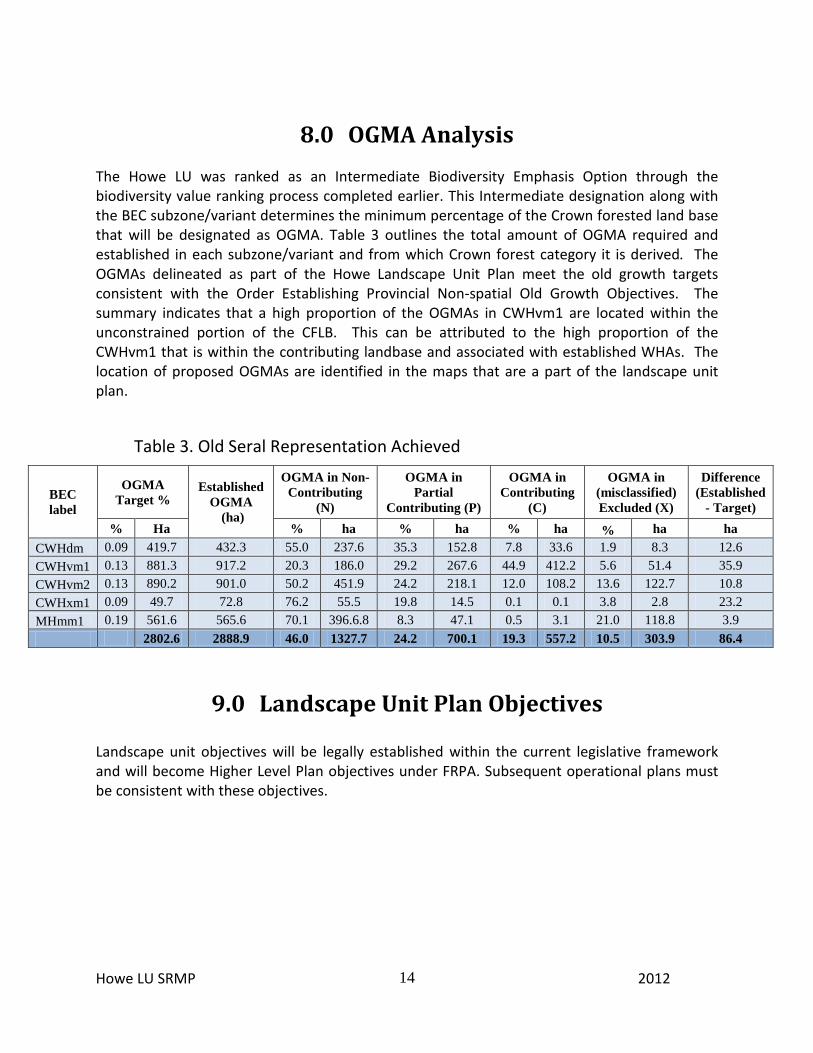
8.0 OGMA Analysis
The Howe LU was ranked as an Intermediate Biodiversity Emphasis Option through the biodiversity value ranking process completed earlier. This Intermediate designation along with the BEC subzone/variant determines the minimum percentage of the Crown forested land base that will be designated as OGMA. Table 3 outlines the total amount of OGMA required and established in each subzone/variant and from which Crown forest category it is derived. The OGMAs delineated as part of the Howe Landscape Unit Plan meet the old growth targets consistent with the Order Establishing Provincial Non-spatial Old Growth Objectives. The summary indicates that a high proportion of the OGMAs in CWHvm1 are located within the unconstrained portion of the CFLB. This can be attributed to the high proportion of the CWHvm1 that is within the contributing landbase and associated with established WHAs. The location of proposed OGMAs are identified in the maps that are a part of the landscape unit plan.
Table 3. Old Seral Representation Achieved
BEC label
OGMA Target %
Established OGMA
(ha)
OGMA in Non-Contributing
(N)
OGMA in Partial
Contributing (P)
OGMA in Contributing
(C)
OGMA in (misclassified) Excluded (X)
Difference (Established
- Target) % Ha % ha % ha % ha % ha ha
CWHdm 0.09 419.7 432.3 55.0 237.6 35.3 152.8 7.8 33.6 1.9 8.3 12.6 CWHvm1 0.13 881.3 917.2 20.3 186.0 29.2 267.6 44.9 412.2 5.6 51.4 35.9 CWHvm2 0.13 890.2 901.0 50.2 451.9 24.2 218.1 12.0 108.2 13.6 122.7 10.8 CWHxm1 0.09 49.7 72.8 76.2 55.5 19.8 14.5 0.1 0.1 3.8 2.8 23.2 MHmm1 0.19 561.6 565.6 70.1 396.6.8 8.3 47.1 0.5 3.1 21.0 118.8 3.9 2802.6 2888.9 46.0 1327.7 24.2 700.1 19.3 557.2 10.5 303.9 86.4
9.0 Landscape Unit Plan Objectives Landscape unit objectives will be legally established within the current legislative framework and will become Higher Level Plan objectives under FRPA. Subsequent operational plans must be consistent with these objectives.
Howe LU SRMP 2012
15
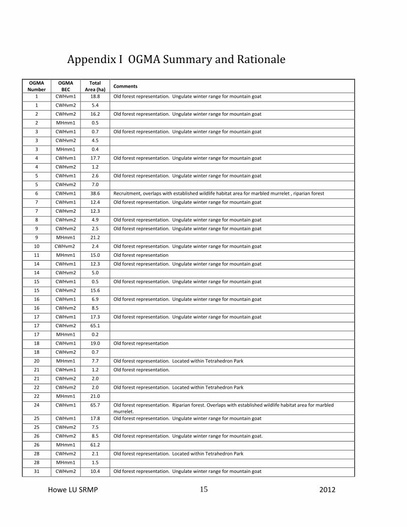
Appendix I OGMA Summary and Rationale
OGMA Number
OGMA BEC
Total Area (ha)
Comments
1 CWHvm1 18.8 Old forest representation. Ungulate winter range for mountain goat
1 CWHvm2 5.4
2 CWHvm2 16.2 Old forest representation. Ungulate winter range for mountain goat
2 MHmm1 0.5
3 CWHvm1 0.7 Old forest representation. Ungulate winter range for mountain goat
3 CWHvm2 4.5
3 MHmm1 0.4
4 CWHvm1 17.7 Old forest representation. Ungulate winter range for mountain goat
4 CWHvm2 1.2
5 CWHvm1 2.6 Old forest representation. Ungulate winter range for mountain goat
5 CWHvm2 7.0
6 CWHvm1 38.6 Recruitment, overlaps with established wildlife habitat area for marbled murrelet , riparian forest
7 CWHvm1 12.4 Old forest representation. Ungulate winter range for mountain goat
7 CWHvm2 12.3
8 CWHvm2 4.9 Old forest representation. Ungulate winter range for mountain goat
9 CWHvm2 2.5 Old forest representation. Ungulate winter range for mountain goat
9 MHmm1 21.2
10 CWHvm2 2.4 Old forest representation. Ungulate winter range for mountain goat
11 MHmm1 15.0 Old forest representation
14 CWHvm1 12.3 Old forest representation. Ungulate winter range for mountain goat
14 CWHvm2 5.0
15 CWHvm1 0.5 Old forest representation. Ungulate winter range for mountain goat
15 CWHvm2 15.6
16 CWHvm1 6.9 Old forest representation. Ungulate winter range for mountain goat
16 CWHvm2 8.5
17 CWHvm1 17.3 Old forest representation. Ungulate winter range for mountain goat
17 CWHvm2 65.1
17 MHmm1 0.2
18 CWHvm1 19.0 Old forest representation
18 CWHvm2 0.7
20 MHmm1 7.7 Old forest representation. Located within Tetrahedron Park
21 CWHvm1 1.2 Old forest representation.
21 CWHvm2 2.0
22 CWHvm2 2.0 Old forest representation. Located within Tetrahedron Park
22 MHmm1 21.0
24 CWHvm1 65.7 Old forest representation. Riparian forest. Overlaps with established wildlife habitat area for marbled murrelet.
25 CWHvm1 17.8 Old forest representation. Ungulate winter range for mountain goat
25 CWHvm2 7.5
26 CWHvm2 8.5 Old forest representation. Ungulate winter range for mountain goat.
26 MHmm1 61.2
28 CWHvm2 2.1 Old forest representation. Located within Tetrahedron Park
28 MHmm1 1.5
31 CWHvm2 10.4 Old forest representation. Ungulate winter range for mountain goat
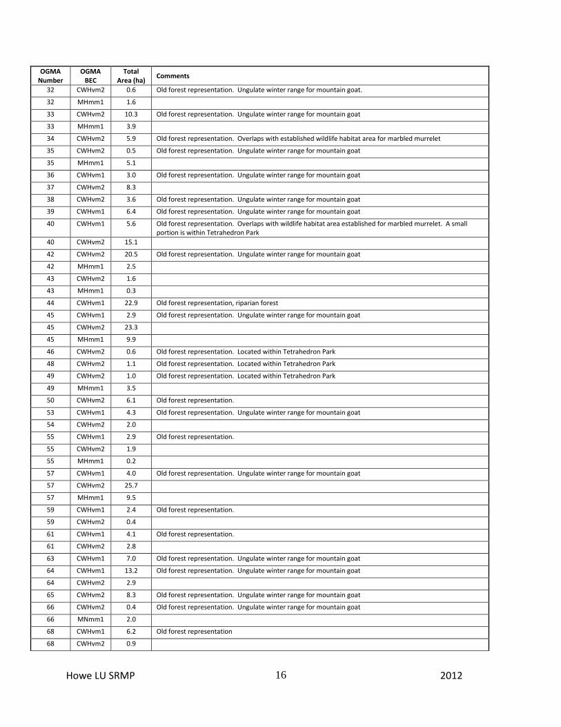
Howe LU SRMP 2012
16
OGMA Number
OGMA BEC
Total Area (ha)
Comments
32 CWHvm2 0.6 Old forest representation. Ungulate winter range for mountain goat.
32 MHmm1 1.6
33 CWHvm2 10.3 Old forest representation. Ungulate winter range for mountain goat
33 MHmm1 3.9
34 CWHvm2 5.9 Old forest representation. Overlaps with established wildlife habitat area for marbled murrelet
35 CWHvm2 0.5 Old forest representation. Ungulate winter range for mountain goat
35 MHmm1 5.1
36 CWHvm1 3.0 Old forest representation. Ungulate winter range for mountain goat
37 CWHvm2 8.3
38 CWHvm2 3.6 Old forest representation. Ungulate winter range for mountain goat
39 CWHvm1 6.4 Old forest representation. Ungulate winter range for mountain goat
40 CWHvm1 5.6 Old forest representation. Overlaps with wildlife habitat area established for marbled murrelet. A small portion is within Tetrahedron Park
40 CWHvm2 15.1
42 CWHvm2 20.5 Old forest representation. Ungulate winter range for mountain goat
42 MHmm1 2.5
43 CWHvm2 1.6
43 MHmm1 0.3
44 CWHvm1 22.9 Old forest representation, riparian forest
45 CWHvm1 2.9 Old forest representation. Ungulate winter range for mountain goat
45 CWHvm2 23.3
45 MHmm1 9.9
46 CWHvm2 0.6 Old forest representation. Located within Tetrahedron Park
48 CWHvm2 1.1 Old forest representation. Located within Tetrahedron Park
49 CWHvm2 1.0 Old forest representation. Located within Tetrahedron Park
49 MHmm1 3.5
50 CWHvm2 6.1 Old forest representation.
53 CWHvm1 4.3 Old forest representation. Ungulate winter range for mountain goat
54 CWHvm2 2.0
55 CWHvm1 2.9 Old forest representation.
55 CWHvm2 1.9
55 MHmm1 0.2
57 CWHvm1 4.0 Old forest representation. Ungulate winter range for mountain goat
57 CWHvm2 25.7
57 MHmm1 9.5
59 CWHvm1 2.4 Old forest representation.
59 CWHvm2 0.4
61 CWHvm1 4.1 Old forest representation.
61 CWHvm2 2.8
63 CWHvm1 7.0 Old forest representation. Ungulate winter range for mountain goat
64 CWHvm1 13.2 Old forest representation. Ungulate winter range for mountain goat
64 CWHvm2 2.9
65 CWHvm2 8.3 Old forest representation. Ungulate winter range for mountain goat
66 CWHvm2 0.4 Old forest representation. Ungulate winter range for mountain goat
66 MNmm1 2.0
68 CWHvm1 6.2 Old forest representation
68 CWHvm2 0.9
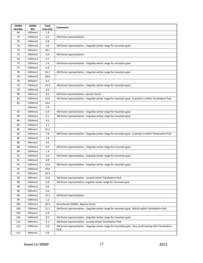
Howe LU SRMP 2012
17
OGMA Number
OGMA BEC
Total Area (ha)
Comments
69 CWHvm1 1.9
70 CWHvm1 0.5 Old forest representation
70 CWHvm2 0.8
72 CWHvm2 4.0 Old forest representation. Ungulate winter range for mountain goat
72 MHmm1 16.1
73 CWHvm1 0.4 Old forest representation
73 CWHvm2 0.7
77 CWHvm1 2.6 Old forest representation. Ungulate winter range for mountain goat
77 CWHvm2 4.4
78 CWHvm1 56.2 Old forest representation. Ungulate winter range for mountain goat
78 CWHvm2 28.6
78 MHmm1 6.5
79 CWHvm1 14.9 Old forest representation. Ungulate winter range for mountain goat
79 CWHvm2 6.0
80 CWHvm1 8.9 Old forest representation, riparian forest
81 CWHvm1 25.6 Old forest representation. Ungulate winter range for mountain goat. A portion is within Tetrahedron Park
81 CHWvm2 14.0
MHmm1 1.9
82 CWHvm2 6.6 Old forest representation. Ungulate winter range for mountain goat
84 CWHvm1 6.1 Old forest representation. Ungulate winter range for mountain goat
84 CWHvm2 4.1
85 CWHvm2 1.2
85 MHmm1 21.2
86 CWHvm1 7.8 Old forest representation. Ungulate winter range for mountain goat. A portion is within Tetrahedron Park
86 CWHvm2 1.4
86 MHmm1 4.5
88 CWHvm1 0.4 Old forest representation. Ungulate winter range for mountain goat.
88 CWHvm2 1.4
91 CWHvm1 3.0 Old forest representation. Ungulate winter range for mountain goat
91 CWHvm2 8.9
92 CWHvm1 11.6 Old forest representation. Ungulate winter range for mountain goat
92 CWHvm2 59.8
92 MHmm1 16.3
93 MHmm1 11.6 Old forest representation. Located within Tetrahedron Park
98 CWHvm1 4.8 Old forest representation, ungulate winter range for mountain goat
98 CWHvm2 9.6
98 MHmm1 0.4
99 CWHvm1 13.2 Old forest representation
99 CWHvm2 1.2
105 CWHvm1 26.3 Recruitment OGMA. Riparian forest
106 CWHvm2 11.1 Old forest representation. Ungulate winter range for mountain goat. Mainly within Tetrahedron Park
106 MHmm1 6.0
110 CWHvm2 8.5 Old forest representation. Ungulate winter range for mountain goat
111 MHmm1 6.3 Old forest representation. Located within Tetrahedron Park
113 CWHvm2 4.6 Old forest representation. Ungulate winter range for mountain goat. Very small overlap with Tetrahedron Park
113 MHmm1 9.0

Howe LU SRMP 2012
18
OGMA Number
OGMA BEC
Total Area (ha)
Comments
115 MHmm1 3.4 Old forest representation. Located within Tetrahedron Park
116 CWHvm2 15.4 Old forest representation. Ungulate winter range for mountain goat
116 MHmm1 5.9
118 CWHvm2 7.9 Old forest representation. Ungulate winter range for mountain goat. Very small overlap with Tetrahedron Park
118 MHmm1 5.0
123 CWHvm2 5.0 Old forest representation.
123 MHmm1 3.1
127 CWHvm2 0.2 Old forest representation. Within Tetrahedron Park
127 MHmm1 3.6
129 MHmm1 2.5 Old forest representation. Within Tetrahedron Park
130 MHmm1 4.2 Old forest representation. Within Tetrahedron Park
131 CWHvm1 3.3
132 MHmm1 1.5 Old forest representation. Within Tetrahedron Park
133 CWHvm1 0.8 Old forest representation. Overlaps with established wildlife habitat area for marbled murrelet
133 CWHvm2 3.1
134 CWHvm2 3.0 Old forest representation. Within Tetrahedron Park
138 CWHvm1 4.8 Recruitment OGMA
139 CWHvm2 22.5 Old forest representation. Within Tetrahedron Park
139 MHmm1 28.9
142 CWHvm2 19.0 Old forest representation. Within Tetrahedron Park
142 MHmm1 72.7
143 CWHvm2 0.8 Old forest representation. Within Tetrahedron Park
143 MHmm1 0.7
144 CWHvm2 3.2 Old forest representation. Within Tetrahedron Park
144 MHmm1 4.2
146 CWHvm2 3.7 Old forest representation. Within Tetrahedron Park
147 CWHvm2 0.4 Old forest representation. Within Tetrahedron Park
147 MHmm1 2.3
148 CWHvm1 2.8
148 CWHvm2 2.8
149 CWHvm2 3.3 Old forest representation. Within Tetrahedron Park
150 CWHvm2 11.4 Old forest representation. Within Tetrahedron Park
150 MHmm1 5.1
153 CWHvm2 0.3 Old forest representation. Within Tetrahedron Park
153 MHmm1 37.8
154 CWHvm2 10.4
154 CWHvm2 1.4
156 CWHvm2 1.5 Old forest representation. Within Tetrahedron Park
156 MHmm1 1.4
162 CWHvm1 21.1 Old forest representation and recruitment
164 CWHvm1 10.4
164 CWHvm2 46.5
164 MHmm1 37.7
165 CWHvm1 7.8 Old forest representation. Riparian forest
167 CWHvm1 2.7
167 CWHvm2 2.6
Howe LU SRMP 2012
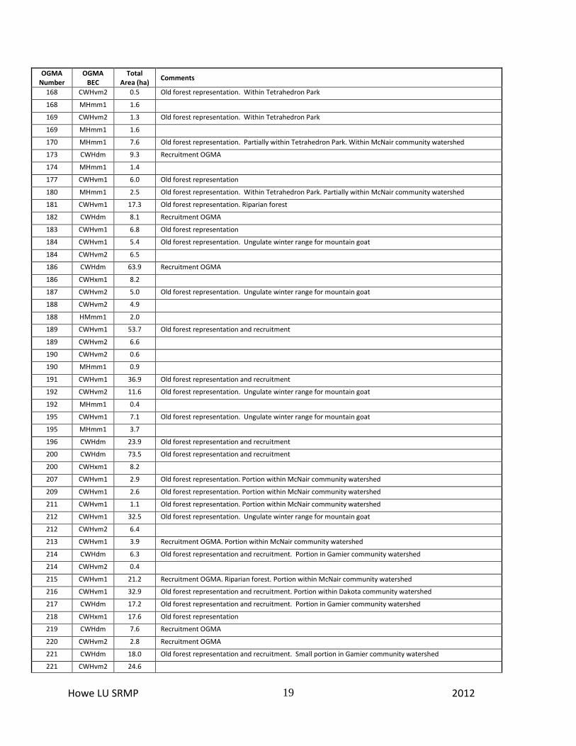
19
OGMA Number
OGMA BEC
Total Area (ha)
Comments
168 CWHvm2 0.5 Old forest representation. Within Tetrahedron Park
168 MHmm1 1.6
169 CWHvm2 1.3 Old forest representation. Within Tetrahedron Park
169 MHmm1 1.6
170 MHmm1 7.6 Old forest representation. Partially within Tetrahedron Park. Within McNair community watershed
173 CWHdm 9.3 Recruitment OGMA
174 MHmm1 1.4
177 CWHvm1 6.0 Old forest representation
180 MHmm1 2.5 Old forest representation. Within Tetrahedron Park. Partially within McNair community watershed
181 CWHvm1 17.3 Old forest representation. Riparian forest
182 CWHdm 8.1 Recruitment OGMA
183 CWHvm1 6.8 Old forest representation
184 CWHvm1 5.4 Old forest representation. Ungulate winter range for mountain goat
184 CWHvm2 6.5
186 CWHdm 63.9 Recruitment OGMA
186 CWHxm1 8.2
187 CWHvm2 5.0 Old forest representation. Ungulate winter range for mountain goat
188 CWHvm2 4.9
188 HMmm1 2.0
189 CWHvm1 53.7 Old forest representation and recruitment
189 CWHvm2 6.6
190 CWHvm2 0.6
190 MHmm1 0.9
191 CWHvm1 36.9 Old forest representation and recruitment
192 CWHvm2 11.6 Old forest representation. Ungulate winter range for mountain goat
192 MHmm1 0.4
195 CWHvm1 7.1 Old forest representation. Ungulate winter range for mountain goat
195 MHmm1 3.7
196 CWHdm 23.9 Old forest representation and recruitment
200 CWHdm 73.5 Old forest representation and recruitment
200 CWHxm1 8.2
207 CWHvm1 2.9 Old forest representation. Portion within McNair community watershed
209 CWHvm1 2.6 Old forest representation. Portion within McNair community watershed
211 CWHvm1 1.1 Old forest representation. Portion within McNair community watershed
212 CWHvm1 32.5 Old forest representation. Ungulate winter range for mountain goat
212 CWHvm2 6.4
213 CWHvm1 3.9 Recruitment OGMA. Portion within McNair community watershed
214 CWHdm 6.3 Old forest representation and recruitment. Portion in Gamier community watershed
214 CWHvm2 0.4
215 CWHvm1 21.2 Recruitment OGMA. Riparian forest. Portion within McNair community watershed
216 CWHvm1 32.9 Old forest representation and recruitment. Portion within Dakota community watershed
217 CWHdm 17.2 Old forest representation and recruitment. Portion in Gamier community watershed
218 CWHxm1 17.6 Old forest representation
219 CWHdm 7.6 Recruitment OGMA
220 CWHvm2 2.8 Recruitment OGMA
221 CWHdm 18.0 Old forest representation and recruitment. Small portion in Gamier community watershed
221 CWHvm2 24.6

Howe LU SRMP 2012
20
OGMA Number
OGMA BEC
Total Area (ha)
Comments
222 CWHvm2 10.2 Old forest representation. Overlaps with established wildlife habitat area for marbled murrelet. Within Dakota community watershed
223 CWHvm1 3.8 Old forest representation and recruitment. Within Dakota community watershed
224 CWHvm1 52.6 Old forest representation. Recruitment forest. Overlaps with established wildlife habitat area for marbled murrelet. Riparian forest. Within Dakota community watershed
224 CWHvm2 35.1
226 CWHdm 52.0 Recruitment OGMA
226 CWHxm1 13.3
227 CWHdm 4.8 Old forest representation
227 CWHxm1 9.4
228 CWHvm2 4.2
230 CWHdm 8.4 Recruitment OGMA. Small portion in Gamier community watershed
231 CWHvm2 3.3 Recruitment OGMA
232 CWHvm2 26.4 Old forest representation. Overlaps with established wildlife habitat area for marbled murrelet. Within Dakota community watershed
234 CWHvm1 9.7
235 CWHvm1 17.4 Old forest representation. Within Dakota community watershed
236 CWHvm1 1.3
238 CWHdm 69.3 Old forest representation and recruitment
238 CWHvm2 0.1
238 CWHxm1 1.5
239 CWHdm 11.6 Recruitment OGMA
240 CWHdm 17.9 Old forest representation and recruitment
240 CWHxm1 0.1
241 CWHdm 2.0 Old forest representation and recruitment
241 CWHxm1 9.7
242 CWHdm 16.2 Old forest representation and recruitment
242 CWHvm1 30.9
245 CWHdm 4.7 Old forest representation and recruitment
245 CWHxm1 4.8
277 CWHdm 17.8
278 MHmm1 33.4 Old forest representation. Overlaps with established wildlife habitat area for marbled murrelet
279 CWHvm2 5.5 Old forest representation. Ungulate winter range for mountain goat. Overlaps with established wildlife habitat for marbled murrelet.
280 CWHvm1 3.5 Old forest representation.
280 MHmm1 11.7
281 CWHvm1 13.5 Recruitment OGMA. Portion within McNair community watershed
282 CWHvm2 0.7 Old forest representation. Ungulate winter range for mountain goat. Overlaps with established wildlife habitat for marbled murrelet.
282 MHmm1 2.4
283 CWHvm2 19.7 Old forest representation. Overlaps with established wildlife habitat area for marbled murrelet. Within Dakota community watershed
284 CWHvm2 0.6 Old forest representation. Ungulate winter range for mountain goat. Overlaps with established wildlife habitat for marbled murrelet.
284 MHmm1 4.5
285 CWHvm1 16.7 Old forest representation. Ungulate winter range for mountain goat
285 CWHvm2 6.5
286 CWHvm1 3.3 Old forest representation. Ungulate winter range for mountain goat
286 CWHvm2 6.8
287 CWHvm1 11.0 Old forest representation
Howe LU SRMP 2012
21
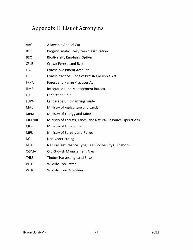
Appendix II List of Acronyms
AAC Allowable Annual Cut
BEC Biogeoclimatic Ecosystem Classification
BEO Biodiversity Emphasis Option
CFLB Crown Forest Land Base
FIA Forest Investment Account
FPC Forest Practices Code of British Columbia Act
FRPA Forest and Range Practices Act
ILMB Integrated Land Management Bureau
LU Landscape Unit
LUPG Landscape Unit Planning Guide
MAL Ministry of Agriculture and Lands
MEM Ministry of Energy and Mines
MFLNRO Ministry of Forests, Lands, and Natural Resource Operations
MOE Ministry of Environment
MFR Ministry of Forests and Range
NC Non-Contributing
NDT Natural Disturbance Type, see Biodiversity Guidebook
OGMA Old Growth Management Area
THLB Timber Harvesting Land Base
WTP Wildlife Tree Patch
WTR Wildlife Tree Retention
Howe LU SRMP 2012
22
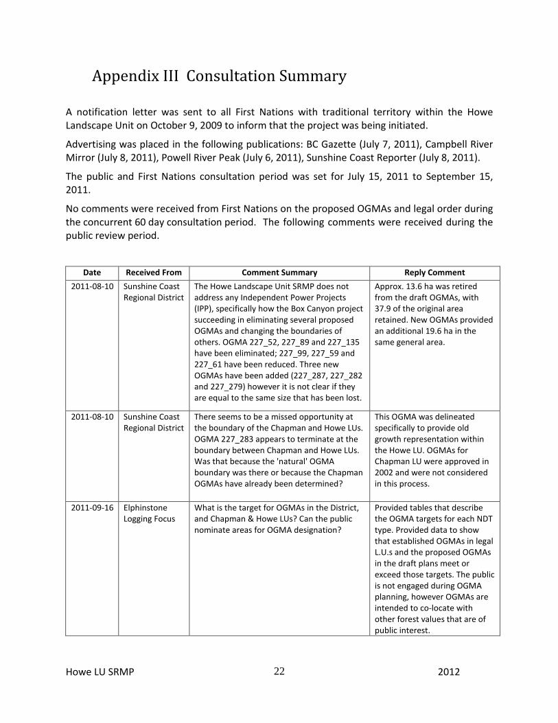
Appendix III Consultation Summary
A notification letter was sent to all First Nations with traditional territory within the Howe Landscape Unit on October 9, 2009 to inform that the project was being initiated.
Advertising was placed in the following publications: BC Gazette (July 7, 2011), Campbell River Mirror (July 8, 2011), Powell River Peak (July 6, 2011), Sunshine Coast Reporter (July 8, 2011).
The public and First Nations consultation period was set for July 15, 2011 to September 15, 2011.
No comments were received from First Nations on the proposed OGMAs and legal order during the concurrent 60 day consultation period. The following comments were received during the public review period.
Date Received From Comment Summary Reply Comment
2011-08-10 Sunshine Coast Regional District
The Howe Landscape Unit SRMP does not address any Independent Power Projects (IPP), specifically how the Box Canyon project succeeding in eliminating several proposed OGMAs and changing the boundaries of others. OGMA 227_52, 227_89 and 227_135 have been eliminated; 227_99, 227_59 and 227_61 have been reduced. Three new OGMAs have been added (227_287, 227_282 and 227_279) however it is not clear if they are equal to the same size that has been lost.
Approx. 13.6 ha was retired from the draft OGMAs, with 37.9 of the original area retained. New OGMAs provided an additional 19.6 ha in the same general area.
2011-08-10 Sunshine Coast Regional District
There seems to be a missed opportunity at the boundary of the Chapman and Howe LUs. OGMA 227_283 appears to terminate at the boundary between Chapman and Howe LUs. Was that because the 'natural' OGMA boundary was there or because the Chapman OGMAs have already been determined?
This OGMA was delineated specifically to provide old growth representation within the Howe LU. OGMAs for Chapman LU were approved in 2002 and were not considered in this process.
2011-09-16 Elphinstone Logging Focus
What is the target for OGMAs in the District, and Chapman & Howe LUs? Can the public nominate areas for OGMA designation?
Provided tables that describe the OGMA targets for each NDT type. Provided data to show that established OGMAs in legal L.U.s and the proposed OGMAs in the draft plans meet or exceed those targets. The public is not engaged during OGMA planning, however OGMAs are intended to co-locate with other forest values that are of public interest.