Embed Size (px)
Citation preview

NASA/TM–2018–220037
HISTORY OF ON-ORBIT SATELLITE FRAGMENTATIONS 15th Edition
Orbital Debris Program Office
Phillip D. Anz-Meador John N. Opiela Debra Shoots
J.-C. Liou
National Aeronautics and Space Administration
Lyndon B. Johnson Space Center Houston, Texas 77058
Publication Date (Information Cut-off Date: 4 July 2018)
https://ntrs.nasa.gov/search.jsp?R=20180008451 2019-02-19T15:52:59+00:00Z

THE NASA STI PROGRAM OFFICE . . . IN PROFILE
Since its founding, NASA has been dedicated to the advancement of aeronautics and space science. The NASA Scientific and Technical Information (STI) Program Office plays a key part in helping NASA maintain this important role.
The NASA STI Program Office is operated by Langley Research Center, the lead center for NASA’s scientific and technical information. The NASA STI Program Office provides access to the NASA STI Database, the largest collection of aeronautical and space science STI in the world. The Program Office is also NASA’s institutional mechanism for disseminating the results of its research and development activities. These results are published by NASA in the NASA STI Report Series, which includes the following report types:
• TECHNICAL PUBLICATION. Reports ofcompleted research or a major significantphase of research that present the results ofNASA programs and include extensive dataor theoretical analysis. Includescompilations of significant scientific andtechnical data and information deemed to beof continuing reference value. NASA’scounterpart of peer-reviewed formalprofessional papers but has less stringentlimitations on manuscript length and extentof graphic presentations.
• TECHNICAL MEMORANDUM. Scientificand technical findings that are preliminaryor of specialized interest, e.g., quick releasereports, working papers, and bibliographiesthat contain minimal annotation. Does notcontain extensive analysis.
• CONTRACTOR REPORT. Scientific andtechnical findings by NASA-sponsoredcontractors and grantees.
• CONFERENCE PUBLICATION. Collectedpapers from scientific and technicalconferences, symposia, seminars, or othermeetings sponsored or cosponsored byNASA.
• SPECIAL PUBLICATION. Scientific,technical, or historical information fromNASA programs, projects, and mission,often concerned with subjects havingsubstantial public interest.
• TECHNICAL TRANSLATION. English-language translations of foreign scientificand technical material pertinent to NASA’smission.
Specialized services that complement the STI Program Office’s diverse offerings include creating custom thesauri, building customized databases, organizing and publishing research results . . . even providing videos.
For more information about the NASA STI Program Office, see the following:
• Access the NASA STI Program Home Pageat http://www.sti.nasa.gov
• E-mail your question via the internet [email protected]
• Fax your question to the NASA Access HelpDesk at (301) 621-0134
• Telephone the NASA Access Help Desk at(301) 621-0390
• Write to:NASA Access Help DeskNASA Center for AeroSpace Information7115 StandardHanover, MD 21076-1320
NASA/TM–2018–220037
HISTORY OF ON-ORBIT SATELLITE FRAGMENTATIONS 15th Edition
Orbital Debris Program Office
Phillip D. Anz-Meador John N. Opiela Debra Shoots
J.-C. Liou
National Aeronautics and Space Administration
Lyndon B. Johnson Space Center Houston, Texas 77058
Publication Date (Information Cut-off Date: 4 July 2018)
Available from:
NASA Center for AeroSpace Information National Technical Information Service 7115 Standard Drive 5285 Port Royal Road Hanover, MD 21076-1320 Springfield, VA 22161 301-621-0390 703-605-6000
This report is also available in electronic form at http://ston.jsc.nasa.gov/collections/TRS/

i
Preface to the Fifteenth Edition
The first edition of the History of On-Orbit Satellite Fragmentations was published by Teledyne Brown Engineering (TBE) in August 1984, under the sponsorship of the NASA Johnson Space Center and with the cooperation of the United States Air Force Space Command and the U.S. Army Ballistic Missile Command. The objective was to bring together information about the 75 satellites, which had at that time experienced noticeable breakups. This update encompasses all known satellite fragmentations. This update is published by the NASA Johnson Space Center Orbital Debris Program Office (ODPO). The information cut-off date for this edition is 4 July 2018.
Since the 14th edition (information cut-off date of 1 August 2007, published in June 2008) there have been 41 identified on-orbit breakups and 18 anomalous events (new or discerned), for a historical total of 242 fragmentations and 78 anomalous events. This activity, in addition to launch activity, has resulted in an approximately 36% increase in the number of cataloged resident space objects since 1 August 2007, which includes on-orbit and decayed objects. More significantly, breakup and anomalous debris accounted for 65% of the catalog growth observed since the last edition. The reason for these large increases was the first accidental collision of two intact spacecraft, Iridium 33 and Cosmos 2251, on 10 February 2009 and the continued cataloging of debris created by the intentional destruction of the Fengyun 1C spacecraft on 11 January 2007. There is no reason to believe that any of these three debris clouds have been cataloged completely, to a limiting RCS, as of this writing. The current authors would like to recognize the substantial contributions of the authors of previous editions of this document. In addition, the assistance of personnel of U.S. Strategic Command, Air Force Space Command, and Naval Network and Space Operations Command (formerly Naval Space Command) has been vital to the present work. Finally, special thanks to Mr. Chris Ostrom of the NASA Orbital Debris Program Office for his thorough review of this 15th edition.

iii
CONTENTS
Preface to the Fifteenth Edition .................................................................................... i
ACRONYMS ................................................................................................................... x
1.0 INTRODUCTION ................................................................................................... 1 1.1 Definition of Terms......................................................................................................... 3 1.2 Information Sources and Accuracy ................................................................................. 4 1.3 Environment Overview ................................................................................................... 5
1.3.1 On-Orbit Spatial Density 5 1.3.2 Population Distribution 7
2.0 SATELLITE BREAKUPS .................................................................................... 11 2.1 Background and Status ................................................................................................. 11 2.2 Identified Satellite Breakups ......................................................................................... 32
TRANSIT 4A R/B 1961-015C 118 ................................................ 34 SPUTNIK 29 1962-057A 443 ................................................ 36 ATLAS CENTAUR 2 1963-047A 694 ................................................ 38 COSMOS 50 1964-070A 919 ................................................ 40 COSMOS 57 1965-012A 1093 .............................................. 42 COSMOS 61-63 R/B 1965-020D 1270 .............................................. 44 COSMOS 95 1965-088A 1706 .............................................. 46 OV2-1/LCS 2 R/B 1965-082DM 1822 .......................................... 48 OV2-3/LES-3,-4/OSCAR 4 R/B 1965-108A 1863 .............................................. 50 OPS 3031 1966-012C 2015 .............................................. 52 GEMINI 9 ATDA R/B 1966-046B 2188 .............................................. 54 PAGEOS 1966-056A 2253 .............................................. 56 AS-203 1966-059A 2289 .............................................. 58 COSMOS U-1 1966-088A 2437 .............................................. 60 COSMOS U-2 1966-101A 2536 .............................................. 62 COSMOS 192 1967-116A 3047 .............................................. 64 COSMOS 199 1968-003A 3099 .............................................. 66 APOLLO 6 R/B 1968-025B 3171 .............................................. 68 OV2-5 R/B 1968-081E 3432 .............................................. 70 COSMOS 248 1968-090A 3503 .............................................. 72 COSMOS 249 1968-091A 3504 .............................................. 74 COSMOS 252 1968-097A 3530 .............................................. 76 ESSA 8 (TOS F) R/B 1968-114B 3616 .............................................. 78 TITAN IIIC TRANSTAGE R/B 1969-013B 3692 .............................................. 80 METEOR 1-1 R/B 1969-029B 3836 .............................................. 82 INTELSAT 3 F-5 R/B 1969-064B 4052 .............................................. 84 OPS 7613 R/B 1969-082AB 4159 ........................................... 86 NIMBUS 4 R/B 1970-025C 4367 .............................................. 88 COSMOS 374 1970-089A 4594 .............................................. 90 COSMOS 375 1970-091A 4598 .............................................. 92 COSMOS 397 1971-015A 4964 .............................................. 94 COSMOS 462 1971-106A 5646 .............................................. 96 LANDSAT 1 R/B 1972-058B 6127 .............................................. 98 SALYUT 2 R/B 1973-017B 6399 ............................................ 100
iv
COSMOS 554 1973-021A 6432 ............................................ 102 NOAA 3 R/B 1973-086B 6921 ............................................ 104 DMSP 5B F5 R/B 1974-015B 7219 ............................................ 106 NOAA 4 R/B 1974-089D 7532 ............................................ 108 COSMOS 699 1974-103A 7587 ............................................ 110 LANDSAT 2 R/B 1975-004B 7616 ............................................ 112 NIMBUS 6 R/B 1975-052B 7946 ............................................ 114 COSMOS 758 1975-080A 8191 ............................................ 116 COSMOS 777 1975-102A 8416 ............................................ 118 COSMOS 838 1976-063A 8932 ............................................ 120 COSMOS 839 1976-067A 9011 ............................................ 122 COSMOS 844 1976-072A 9046 ............................................ 124 NOAA 5 R/B 1976-077B 9063 ............................................ 126 COSMOS 862 1976-105A 9495 ............................................ 128 COSMOS 880 1976-120A 9601 ............................................ 130 COSMOS 884 1976-123A 9614 ............................................ 132 COSMOS 886 1976-126A 9634 ............................................ 134 COSMOS 903 1977-027A 9911 ............................................ 136 COSMOS 917 1977-047A 10059 .......................................... 138 HIMAWARI 1 R/B 1977-065B 10144 .......................................... 140 COSMOS 931 1977-068A 10150 .......................................... 142 EKRAN 2 1977-092A 10365 .......................................... 144 COSMOS 970 1977-121A 10531 .......................................... 146 LANDSAT 3 R/B 1978-026C 10704 .......................................... 148 COSMOS 1030 1978-083A 11015 .......................................... 150 NIMBUS 7 R/B 1978-098B 11081 .......................................... 152 COSMOS 1045 R/B 1978-100D 11087 .......................................... 154 P-78 (SOLWIND) 1979-017A 11278 .......................................... 156 COSMOS 1094 1979-033A 11333 .......................................... 158 COSMOS 1109 1979-058A 11417 .......................................... 160 COSMOS 1124 1979-077A 11509 .......................................... 162 SATCOM 3 1979-101A 11635 .......................................... 164 CAT R/B 1979-104B 11659 .......................................... 166 COSMOS 1167 1980-021A 11729 .......................................... 168 COSMOS 1174 1980-030A 11765 .......................................... 170 COSMOS 1188 1980-050A 11844 .......................................... 172 COSMOS 1191 1980-057A 11871 .......................................... 174 COSMOS 1217 1980-085A 12032 .......................................... 176 COSMOS 1220 1980-089A 12054 .......................................... 178 COSMOS 1247 1981-016A 12303 .......................................... 180 COSMOS 1260 1981-028A 12364 .......................................... 182 COSMOS 1261 1981-031A 12376 .......................................... 184 COSMOS 1275 1981-053A 12504 .......................................... 186 COSMOS 1278 1981-058A 12547 .......................................... 188 COSMOS 1285 1981-071A 12627 .......................................... 190 COSMOS 1286 1981-072A 12631 .......................................... 192 COSMOS 1305 R/B 1981-088F 12827 ........................................... 194 COSMOS 1306 1981-089A 12828 .......................................... 196 COSMOS 1317 1981-108A 12933 .......................................... 198 COSMOS 1348 1982-029A 13124 .......................................... 200 COSMOS 1355 1982-038A 13150 .......................................... 202
v
COSMOS 1375 1982-055A 13259 .......................................... 204 COSMOS 1405 1982-088A 13508 .......................................... 206 COSMOS 1423 R/B 1982-115E 13696 .......................................... 208 ASTRON ULLAGE MOTOR 1983-020B 13902 .......................................... 210 NOAA 8 1983-022A 13923 .......................................... 212 COSMOS 1456 1983-038A 14034 .......................................... 214 COSMOS 1461 1983-044A 14064 .......................................... 216 COSMOS 1481 1983-070A 14182 .......................................... 218 COSMOS 1484 1983-075A 14207 .......................................... 220 COSMOS 1519-1521 ULLAGE MOTOR 1983-127H 14608 .......................................... 222 PALAPA B2 R/B 1984-011E 14693 .......................................... 224 WESTAR 6 R/B 1984-011F 14694 ........................................... 226 COSMOS 1588 1984-083A 15167 .......................................... 228 COSMOS 1603 ULLAGE MOTOR 1984-106F 15338 ........................................... 230 SPACENET 2/MARECS B2 R/B 1984-114C 15388 .......................................... 232 COSMOS 1646 1985-030A 15653 .......................................... 234 COSMOS 1650-1652 ULLAGE MOTOR 1985-037G 15714 .......................................... 236 COSMOS 1654 1985-039A 15734 .......................................... 238 COSMOS 1656 ULLAGE MOTOR 1985-042E 15773 .......................................... 240 COSMOS 1682 1985-082A 16054 .......................................... 242 COSMOS 1691 1985-094B 16139 .......................................... 244 COSMOS 1703 R/B 1985-108B 16263 .......................................... 246 COSMOS 1714 R/B 1985-121F 16439 ........................................... 248 COSMOS 1710-1712 ULLAGE MOTOR 1985-118L 16446 .......................................... 250 SPOT 1 R/B 1986-019C 16615 .......................................... 252 COSMOS 1769 1986-059A 16895 .......................................... 254 USA 19 1986-069A 16937 .......................................... 256 USA 19 R/B 1986-069B 16938 .......................................... 258 COSMOS 1813 1987-004A 17297 .......................................... 260 COSMOS 1823 1987-020A 17535 .......................................... 262 COSMOS 1866 1987-059A 18184 .......................................... 264 COSMOS 1869 1987-062A 18214 .......................................... 266 METEOR 2-16 R/B 1987-068B 18313 .......................................... 268 AUSSAT K3/ECS 4 R/B 1987-078C 18352 .......................................... 270 COSMOS 1883-1885 ULLAGE MOTOR 1987-079G 18374 .......................................... 272 COSMOS 1883-1885 ULLAGE MOTOR 1987-079H 18375 .......................................... 274 COSMOS 1906 1987-108A 18713 .......................................... 276 EKRAN 17 ULLAGE MOTOR 1987-109E 18719 .......................................... 278 METEOR 2-17 1988-005A 18820 .......................................... 280 DMSP 5D-2 F9 (USA 29) 1988-006A 18822 .......................................... 282 COSMOS 1916 1988-007A 18823 .......................................... 284 COSMOS 1934 1988-023A 18985 .......................................... 286 INTELSAT 513 R/B 1988-040B 19122 .......................................... 288 COSMOS 1970-1972 ULLAGE MOTOR 1988-085F 19535 ........................................... 290 COSMOS 1970-1972 ULLAGE MOTOR 1988-085G 19537 .......................................... 292 SKYNET 4B/ASTRA 1A R/B 1988-109C 19689 .......................................... 294 COSMOS 1987-1989 ULLAGE MOTOR 1989-001G 19755 .......................................... 296 COSMOS 1987-1989 ULLAGE MOTOR 1989-001H 19856 .......................................... 298 GORIZONT 17 ULLAGE MOTOR 1989-004E 19771 .......................................... 300 ARIANE 2 R/B 1989-006B 19773 .......................................... 302 COSMOS 2022-2024 ULLAGE MOTOR 1989-039G 20081 .......................................... 304
vi
GORIZONT 18 ULLAGE MOTOR 1989-052F 20116 ........................................... 306 COSMOS 2030 1989-054A 20124 .......................................... 308 COSMOS 2031 1989-056A 20136 .......................................... 310 COBE R/B 1989-089B 20323 .......................................... 312 COSMOS 2053 R/B 1989-100B 20390 .......................................... 314 COSMOS 2054 ULLAGE MOTOR 1989-101E 20399 .......................................... 316 COSMOS 2079-81 ULLAGE MOTOR 1990-045F 20630 ........................................... 318 COSMOS 2079-2081 ULLAGE MOTOR 1990-045G 20631 .......................................... 320 FENGYUN 1-2 R/B 1990-081D 20791 .......................................... 322 COSMOS 2101 1990-087A 20828 .......................................... 324 GORIZONT 22 ULLAGE MOTOR 1990-102E 20957 .......................................... 326 USA 68 1990-105A 20978 .......................................... 328 COSMOS 2109-2111 ULLAGE MOTOR 1990-110G 21012 .......................................... 330 COSMOS 2109-2111 ULLAGE MOTOR 1990-110H 21013 .......................................... 332 ITALSAT 1/EUTELSAT 2 F2 R/B 1991-003C 21057 .......................................... 334 COSMOS 2125-2132 R/B 1991-009J 21108 ........................................... 336 COSMOS 2133 ULLAGE MOTOR 1991-010D 21114 .......................................... 338 ASTRA 1B/MOP 2 R/B 1991-015C 21141 .......................................... 340 COSMOS 2139-41 ULLAGE MOTOR 1991-025F 21220 ........................................... 342 COSMOS 2139-2141 ULLAGE MOTOR 1991-025G 21226 .......................................... 344 COSMOS 2157-2162 R/B 1991-068G 21734 .......................................... 346 COSMOS 2163 1991-071A 21741 .......................................... 348 INTELSAT 601 R/B 1991-075B 21766 .......................................... 350 USA 73 1991-082A 21798 .......................................... 352 TELECOM 2B/INMARSAT 2 R/B 1992-021C 21941 .......................................... 354 INSAT 2A/EUTELSAT 2F4 R/B 1992-041C 22032 .......................................... 356 COSMOS 2204-2206 ULLAGE MOTOR 1992-047G 22066 .......................................... 358 COSMOS 2204-2206 ULLAGE MOTOR 1992-047H 22067 .......................................... 360 GORIZONT 27 ULLAGE MOTOR 1992-082F 22250 ........................................... 362 COSMOS 2224 ULLAGE MOTOR 1992-088F 22274 ........................................... 364 COSMOS 2225 1992-091A 22280 .......................................... 366 COSMOS 2227 R/B 1992-093B 22285 .......................................... 368 COSMOS 2237 R/B 1993-016B 22566 .......................................... 370 COSMOS 2238 1993-018A 22585 .......................................... 372 COSMOS 2243 1993-028A 22641 .......................................... 374 COSMOS 2251 1993-036A 22675 .......................................... 376 COSMOS 2259 1993-045A 22716 .......................................... 378 COSMOS 2262 1993-057A 22789 .......................................... 380 GORIZONT 29 ULLAGE MOTOR 1993-072E 22925 .......................................... 382 CLEMENTINE R/B 1994-004B 22974 .......................................... 384 STEP II R/B 1994-029B 23106 .......................................... 386 COSMOS 2282 ULLAGE MOTOR 1994-038F 23174 ........................................... 388 ELEKTRO ULLAGE MOTOR 1994-069E 23338 .......................................... 390 COSMOS 2294-96 ULLAGE MOTOR 1994-076G 23402 .......................................... 392 RS-15 R/B 1994-085B 23440 .......................................... 394 DMSP 5D-2 F13 (USA 109) 1995-015A 23533 .......................................... 396 COSMOS 2313 1995-028A 23596 .......................................... 398 CERISE 1995-033B 23606 .......................................... 400 COSMOS 2316-2318 ULLAGE MOTOR 1995-037K 23631 .......................................... 402 RADUGA 33 R/B 1996-010D 23797 .......................................... 404 GORIZONT 32 ULLAGE MOTOR 1996-034F 23887 ........................................... 406
vii
COSMOS 2343 1997-024A 24805 .......................................... 408 IRIDIUM 33 1997-051C 24946 .......................................... 410 KUPON ULLAGE MOTOR 1997-070F 25054 ........................................... 412 COSMOS 2347 1997-079A 25088 .......................................... 414 ASIASAT 3 R/B (2) 1997-086D 25129 .......................................... 416 COMETS R/B 1998-011B 25176 .......................................... 418 ARGOS/ORSTED/SUNSAT R/B 1999-008D 25637 .......................................... 420 FENGYUN 1C 1999-025A 25730 .......................................... 422 CBERS 1 1999-057A 25940 .......................................... 424 CBERS-1/SACI-1 R/B 1999-057C 25942 .......................................... 426 COSMOS 2367 1999-072A 26040 .......................................... 428 COSMOS 2371 ULLAGE MOTOR 2000-036E 26398 .......................................... 430 NOAA 16 2000-055A 26536 .......................................... 432 TES R/B 2001-049D 26960 .......................................... 434 COSMOS 2383 2001-057A 27053 .......................................... 436 COSMOS 2392 ULLAGE MOTOR 2002-037E 27474 .......................................... 438 COSMOS 2392 ULLAGE MOTOR 2002-037F 27475 ........................................... 440 COSMOS 2399 2003-035A 27856 .......................................... 442 ALOS-1 R/B 2006-002B 28932 .......................................... 444 ARABSAT 4 BRIZ-M R/B 2006-006B 28944 .......................................... 446 YAOGAN 1 2006-015A 29092 .......................................... 448 COSMOS 2421 2006-026A 29247 .......................................... 450 IGS 3A R/B 2006-037B 29394 .......................................... 452 COSMOS 2423 2006-039A 29402 .......................................... 454 DMSP 5D-3 F17 R/B 2006-050B 29523 .......................................... 456 USA 193 2006-057A 29651 .......................................... 458 COSMOS 2424-2426 ULLAGE MOTOR 2006-062G 29680 .......................................... 460 BEIDOU 1D R/B 2007-003B 30324 .......................................... 462 IGS 4A/4B R/B DEBRIS 2007-005E 30590 .......................................... 464 COSMOS 2428 2007-029A 31792 .......................................... 466 COSMOS 2431-33 ULLAGE MOTOR 2007-052F 32280 ........................................... 468 USA 197 R/B 2007-054B 32288 .......................................... 470 COSMOS 2434-36 ULLAGE MOTOR 2007-065G 32399 .......................................... 472 AMC 14 BRIZ-M R/B 2008-011B 32709 .......................................... 474 COSMOS 2442-44 ULLAGE MOTOR 2008-046H 33385 .......................................... 476 COSMOS 2447-2449 ULLAGE MOTOR 2008-067G 33472 .......................................... 478 COSMOS 2447-2449 ULLAGE MOTOR 2008-067H 33473 .......................................... 480 BEIDOU G2 2009-018A 34779 .......................................... 482 COSMOS 2459-61 ULLAGE MOTOR 2010-007G 36406 .......................................... 484 COSMOS 2459-2461 ULLAGE MOTOR 2010-007H 36407 .......................................... 486 COSMOS 2464-2466 ULLAGE MOTOR 2010-041G 37143 .......................................... 488 CHINASAT 6A R/B 2010-042B 37151 .......................................... 490 BEIDOU G4 R/B 2010-057B 37211 .......................................... 492 SL-23 DEB 2011-037B 37756 .......................................... 494 NIGCOMSAT 1R R/B 2011-077B 38015 .......................................... 496 BEIDOU G5 R/B 2012-008B 38092 .......................................... 498 NIMIQ 6 R/B 2012-026B 38343 .......................................... 500 TELKOM 3 / EXPRESS MD2 BRIZ-M R/B 2012-044C 38746 .......................................... 502 CASSIOPE R/B 2013-055G 39271 .......................................... 504 SENTINEL 1A 2014-016A 39634 .......................................... 506 PROGRESS-M 27M R/B 2015-024A 40620 .......................................... 508

viii
COSMOS 2513 R/B 2015-075B 41122 .......................................... 510 ASTRO H (HITOMI) 2016-012A 41337 .......................................... 512 FREGAT DEB (TANK) 2017-086C 43089 .......................................... 514
3.0 SATELLITE ANOMALOUS EVENTS ............................................................... 517 3.1 Background and Status ............................................................................................... 517 3.2 Identified Satellite Anomalous Events ........................................................................ 518
VANGUARD 3 1959-007A 20 ................................................ 525 TRANSIT 5B-2 1963-049B 704 .............................................. 526 ELEKTRON 1 1964-006A 746 .............................................. 527 OPS 4412 (TRANSIT 9) 1964-026A 801 .............................................. 528 COSMOS 44 R/B 1964-053B 877 .............................................. 529 OPS 4988 (GREB 6) 1965-016A 1271 ............................................ 530 OPS 4682 (SNAPSHOT) 1965-027A 1314 ............................................ 531 OPS 8480 (TRANSIT 5B-6) 1965-048A 1420 ............................................ 532 ALOUETTE 2 1965-098A 1804 ............................................ 533 FR-1 R/B 1965-101B 1815 ............................................ 534 OPS 1509 (TRANSIT 10) 1965-109A 1864 ............................................ 535 OPS 1593 (TRANSIT 11) 1966-005A 1952 ............................................ 536 OPS 1117 (TRANSIT 12) 1966-024A 2119 ............................................ 537 NIMBUS 2 1966-040A 2173 ............................................ 538 OPS 0856 (MIDAS 11) 1966-077A 2403 ............................................ 539 OPS 0100 (TRANSIT 15) 1967-034A 2754 ............................................ 540 OPS 7218 (TRANSIT 16) 1967-048A 2807 ............................................ 541 OPS 4947 (TRANSIT 17) 1967-092A 2965 ............................................ 542 COSMOS 206 R/B 1968-019B 3151 ............................................ 543 ISIS 1 1969-009A 3669 ............................................ 544 TRANSIT 19 1970-067A 4507 ............................................ 545 METEOR 1-7 R/B 1971-003B 4850 ............................................ 546 METEOR 1-12 R/B 1972-049B 6080 ............................................ 547 COSMOS 539 1972-102A 6319 ............................................ 548 GEOS 3 R/B 1975-027B 7735 ............................................ 549 KYOKKOH 1 (EXOS-A) 1978-014A 10664 .......................................... 550 SEASAT 1978-064A 10967 .......................................... 551 COSMOS 1043 1978-094A 11055 .......................................... 552 TIROS N 1978-096A 11060 .......................................... 553 NIMBUS 7 R/B 1978-098B 11081 .......................................... 554 NOAA 6 1979-057A 11416 .......................................... 555 METEOR 2-5 1979-095A 11605 .......................................... 556 METEOR 2-7 1981-043A 12456 .......................................... 557 METEOR 2-7 R/B 1981-043B 12457 .......................................... 558 MOLNIYA 3-16 R/B 1981-054E 12519 .......................................... 559 NOAA 7 1981-059A 12553 .......................................... 560 COSMOS 1417 R/B 1982-102B 13618 .......................................... 561 NOAA 8 1983-022A 13923 .......................................... 562 OSCAR 30 1985-066A 15935 .......................................... 563 COSMOS 1689 R/B 1985-090B 16111 .......................................... 564 NOAA 10 1986-073A 16969 .......................................... 565 COSMOS 1818 1987-011A 17369 .......................................... 566 COSMOS 1823 1987-020A 17535 .......................................... 567 METEOR 2-17 1988-005A 18820 .......................................... 568
ix
COSMOS 1867 1987-060A 18187 .......................................... 569 COSMOS 1939 R/B 1988-032B 19046 .......................................... 570 NOAA 11 1988-089A 19531 .......................................... 571 COBE 1989-089A 20322 .......................................... 572 NADEZHDA 2 R/B 1990-017B 20509 .......................................... 573 HST 1990-037B 20580 .......................................... 574 NOAA 12 1991-032A 21263 .......................................... 575 OKEAN 3 1991-039A 21397 .......................................... 576 ERS-1 1991-050A 21574 .......................................... 577 SARA 1991-050E 21578 .......................................... 578 ERS-1 R/B 1991-050F 21610 ........................................... 579 UARS 1991-063B 21701 .......................................... 580 EKA 1 (START 1) 1993-014A 22561 .......................................... 581 START 1 R/B 1993-014B 22562 .......................................... 582 USA 106 (DMSP 5D-2 F12) 1994-057A 23233 .......................................... 583 COSMOS 2297 R/B 1994-077B 23405 .......................................... 584 NOAA 14 1994-089A 23455 .......................................... 585 ERS-2 1995-021A 23560 .......................................... 586 ERS-2 R/B 1995-021B 23561 .......................................... 587 KOREASAT 1 R/B 1995-041B 23640 .......................................... 588 RADARSAT R/B 1995-059B 23711 .......................................... 589 IRS B3 1996-017A 23827 .......................................... 590 IRIDIUM 47 1997-082C 25106 .......................................... 591 FUSE 1999-035A 25791 .......................................... 592 TELKOM 1 1999-042A 25880 .......................................... 593 IKONOS 2 1999-051A 25919 .......................................... 594 JASON 1 2001-055A 26997 .......................................... 595 IRIDIUM 91 2002-005A 27372 .......................................... 596 AMC-9 (GE-12) 2003-024A 27820 .......................................... 597 BLITS 2009-049G 35871 .......................................... 598 WORLDVIEW 2 2009-055A 35946 .......................................... 599 HAIYANG 2A 2011-043A 37781 .......................................... 600 RISAT 1 2012-017A 38248 .......................................... 601 BRIZ-KM R/B 2015-020E 40556 .......................................... 602
4.0 OTHER SATELLITES ASSOCIATED WITH FRAGMENTATIONS .................. 604 4.1 Aerodynamic Associations with Fragmentation Events ............................................. 604 4.2 Reactor Coolant Debris ............................................................................................... 610 4.3 Spurious Associations with Fragmentation Events..................................................... 610
5.0 SATELLITES NOT ASSOCIATED WITH BREAKUPS .................................... 614
6.0 SATELLITES NOT ASSOCIATED WITH ANOMALOUS EVENTS .................. 620
x
ACRONYMS
ADCOM (USAF) Aerospace Defense Command AFB Air Force Base AFSPC Air Force Space Command AFSSS Air Force Space Surveillance System (formerly NAVSPASUR) AN/FPS-85 See FPS-85 Asc Ascending BMEWS Ballistic Missile Early Warning System CIS Commonwealth of Independent States (see also USSR) Dsc Descending ESA European Space Agency ESRO European Space Research Organization FPS-85 Phased-array UHF radar at Eglin AFB, Florida GEO Geosynchronous Orbit (orbit category) GEODSS Ground-based Electro-Optical Deep-space Surveillance System JSC Johnson Space Center (NASA) LEO Low Earth Orbit, up to 2000 km altitude (orbit category) NASA National Aeronautics and Space Administration NAVSPASUR Naval Space Surveillance System NAVSPOC Naval Space Operations Center NORAD North American Aerospace Defense Command PARCS Phased-array UHF radar at Cavalier AFB, North Dakota: the Perimeter Acquisition Radar
Attack Characterization System RAE The Royal Aerospace Establishment R/B Rocket Body or Rocket Booster RCS Radar Cross Section RORSAT Radar Ocean Reconnaissance Satellite RSO Resident Space Object SATRAK PC compatible astrodynamics toolkit SCC formerly Space Computational Center (obsolete); now Space Control Center SOZ Sistema Obespechanya Zapuska (Proton-K Block DM attitude/ullage motor unit) SSN Space Surveillance Network TBE Teledyne Brown Engineering TLE Two-Line Element Set USSPACECOM United States Space Command USSR/CIS Union of Soviet Socialist Republics/Commonwealth of Independent States (after 1991)
SYMBOLS
∆P The maximum observed change in the orbital period [min]. ∆I The maximum observed change in the inclination [°].

1
1.0 INTRODUCTION Since the first serious satellite fragmentation occurred in June 1961, which instantaneously increased the total Earth satellite population by more than 400%, the issue of space operations within the finite region of space around the Earth has been the subject of increasing interest and concern. The prolific satellite fragmentations of the 1970s and the marked increase in the number of fragmentations in the 1980s served to widen international research into the characteristics and consequences of such events. Continued events in all orbits in later years make definition and historical accounting of those events crucial to future research. Large, manned space stations and the growing number of operational robotic satellites demand a better understanding of the hazards of the dynamic Earth satellite population.
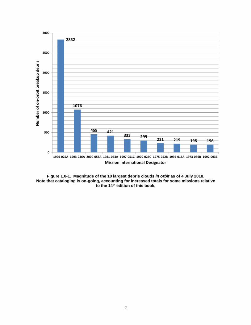
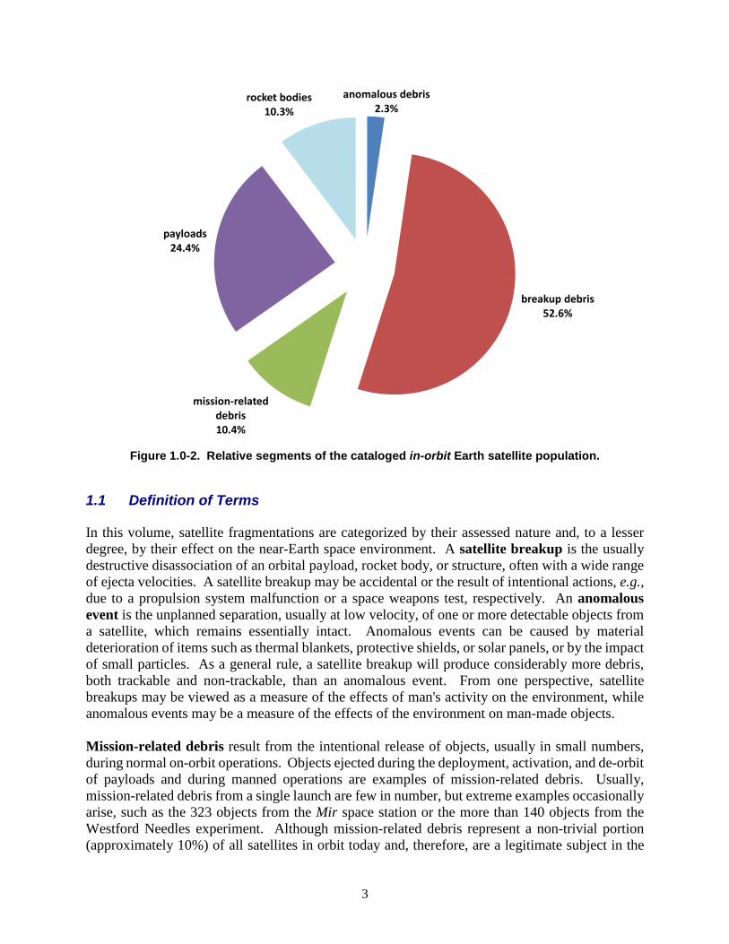
The contribution of satellite fragmentations to the growth of the Earth satellite population is complex and varied. A slight majority of detectable fragmentation debris has already fallen out of orbit, and the effects of 38% of all breakups have completely disappeared. On the other hand, just 10 of the 5385 space missions flown since 1957 are responsible for 33% of all cataloged artificial Earth satellites presently in orbit (Figure 1.0-1). Moreover, the sources of four of these 10 fragmentations were discarded rocket bodies that had operated as designed, but later broke up. Modern debris mitigation best practices would have prevented these six events. The remaining six fragmentations are diverse in character. The oldest, the fragmentation of Cosmos 1275, is assessed by Russian authorities to have been caused by a battery fragmentation. Two, USA 109 and NOAA 16, share a similar spacecraft bus. More recently, the intentional fragmentation of the Fengyun 1C meteorological payload (1999-025) by an Anti-Satellite (ASAT) weapon and the first accidental collision of large intact spacecraft, Cosmos 2251 (1993-036) and Iridium 33 (1997-051), together account for over 30% of all cataloged resident space objects (RSOs). The breakup fragments associated with these three spacecraft account for almost 13% of all objects cataloged since the launch of Sputnik 1 on 4 October 1957. The primary factors affecting the growth of the true Earth satellite population are the international space launch rate, satellite fragmentations, and solar activity. As of 4 July 2018, breakup debris have surpassed half of the cataloged Earth satellite population, as illustrated in Figure 1.0-2. Also, approximately three out of every four payloads are no longer operational and constitute a separate, but statistically important class of orbital debris.
2
Figure 1.0-1. Magnitude of the 10 largest debris clouds in orbit as of 4 July 2018. Note that cataloging is on-going, accounting for increased totals for some missions relative
to the 14th edition of this book.
2832
1076
458 421333 299 231 219 198 196
0
500
1000
1500
2000
2500
3000
1999-025A 1993-036A 2000-055A 1981-053A 1997-051C 1970-025C 1975-052B 1995-015A 1973-086B 1992-093B
Num
ber o
f on-
orbi
t bre
akup
deb
ris
Mission International Designator
3
Figure 1.0-2. Relative segments of the cataloged in-orbit Earth satellite population.
1.1 Definition of Terms In this volume, satellite fragmentations are categorized by their assessed nature and, to a lesser degree, by their effect on the near-Earth space environment. A satellite breakup is the usually destructive disassociation of an orbital payload, rocket body, or structure, often with a wide range of ejecta velocities. A satellite breakup may be accidental or the result of intentional actions, e.g., due to a propulsion system malfunction or a space weapons test, respectively. An anomalous event is the unplanned separation, usually at low velocity, of one or more detectable objects from a satellite, which remains essentially intact. Anomalous events can be caused by material deterioration of items such as thermal blankets, protective shields, or solar panels, or by the impact of small particles. As a general rule, a satellite breakup will produce considerably more debris, both trackable and non-trackable, than an anomalous event. From one perspective, satellite breakups may be viewed as a measure of the effects of man's activity on the environment, while anomalous events may be a measure of the effects of the environment on man-made objects.
Mission-related debris result from the intentional release of objects, usually in small numbers, during normal on-orbit operations. Objects ejected during the deployment, activation, and de-orbit of payloads and during manned operations are examples of mission-related debris. Usually, mission-related debris from a single launch are few in number, but extreme examples occasionally arise, such as the 323 objects from the Mir space station or the more than 140 objects from the Westford Needles experiment. Although mission-related debris represent a non-trivial portion (approximately 10%) of all satellites in orbit today and, therefore, are a legitimate subject in the
anomalous debris2.3%
breakup debris52.6%
mission-related debris10.4%
payloads24.4%
rocket bodies10.3%
4
study of methods to retard the growth of the Earth satellite population, identification of the thousands of mission-related debris events is beyond the scope of this report.
1.2 Information Sources and Accuracy A number of data sources were employed in the compilation of this volume. However, nearly all are derived from observations collected by the U.S. Space Surveillance Network (US SSN). Due to the variety of sources and geodetic models used to create satellite orbital element sets, all altitudes cited within this volume are presented to the nearest 5 km, referenced to a mean Earth of radius 6378.135 km. The accuracy of the data presented is not of adequate fidelity for precision analysis, although it is appropriate for the anticipated uses of this text. Complete base element sets are provided, but manipulation of these data, in particular satellite orbit propagation, should be performed only with validated, Air Force Space Command (AFSPC)-derived software, such as the PC-compatible SATRAK astrodynamics toolkit. Long-term propagation of these elements is not appropriate regardless of the propagation technique applied and is, therefore, discouraged. Although all fragmentations are described by the number of debris cataloged and the number of cataloged debris remaining in orbit, these parameters are poor measures of merit and should be used with extreme caution when undertaking comparative analyses. The sensitivity of the SSN and hence the degree to which debris will be detected and cataloged are highly dependent upon satellite altitude and to a lesser degree on satellite inclination. Additionally, historical cataloging practices have changed over the years. Past practices have included cataloging all debris objects associated with a breakup, even if they had already decayed; cataloging almost no pieces from a low altitude breakup when decay of most of the cloud was imminent; and cataloging objects as they were created, regardless of status. These different practices have resulted in an inconsistent historical record. As a rule of thumb, low altitude, cataloged debris are assessed to be larger than 10 cm in diameter. At higher altitudes objects less than 1 m in diameter may be undetectable. Individual object sensitivities may vary dramatically from this simple generalization. Debris counts for fragmentations occurring in highly elliptical orbits near 63° inclination (Molniya-type) are traditionally low, in part due to stable perigees situated deep in the Southern Hemisphere and often beyond SSN coverage. In February of 2007 a Briz-M upper stage broke up into over 1000 observed fragments. However, due to the elliptical nature of the stage’s orbit which impeded the SSN’s ability to detect, to identify, and to catalog the debris, only 102 fragments had been cataloged, of which 92 remain on orbit. Similar outcomes may occur in practice with other Briz-M upper stage fragmentations. During a special surveillance session in 1987, as many as 250 uncataloged objects were observed in low inclination, highly elliptical orbits, but reliable tracking and parent identification were not achieved. The disclosure by the Russian Government of the Ekran 2 battery explosion on 25 June 1978 is the first known fragmentation in geostationary orbit. This event was not detected by the SSN, but since the event, four pieces have entered the catalog. Cataloging errors, e.g., identification of an object with the wrong parent satellite, normally are not explicitly noted in this volume since many errors have been or may be corrected. For fragmentations at very low altitudes, i.e., below 400 km, much of the debris may reenter before detection, identification, and cataloging can be completed. For example, when the debris cloud from Cosmos 1813 passed over a single SSN radar, 846 individual fragments could be discerned.
5
However, the total number of debris officially cataloged only reached 195. Likewise, more than 380 fragments are known to have been injected into Earth orbits (an equal number probably were sent on reentry trajectories) following the USA 19 test, but only 18 debris were entered into the official satellite catalog.
1.3 Environment Overview To place the debris population component of the orbital environment in context for the reader, it is useful to review the general orbital environment in the near Earth and near geosynchronous regions. Differentiation of the population by source, object type, and orbit type are also included below.
1.3.1 ON-ORBIT SPATIAL DENSITY The spatial density of resident space objects is a common means of describing the space object environment and is adopted here. Spatial density (objects per unit volume) represents the effective number of spacecraft and other objects as a function of altitude. Effective number, rather than the simple counting of objects, is used because many objects traverse the altitude regions of interest yet contribute little to the local collision hazard, e.g., geosynchronous transfer orbits. Such orbits exhibit an effective contribution to the environment at any given altitude of up to two orders of magnitude less than an object in a circular orbit within this same altitude interval. Thus, circular orbits at or near an orbit of interest normally dominate the hazard environment. The following figure portrays the near Earth (up to 2000 km altitude) environment categorized by intact or debris object types. The densities are subdivided into 5-km altitude intervals and graphed linearly. The epoch of the source data, a US SSN Two-Line Element (TLE) set, is 2 October 2018.

6
Figure 1.3.1-1. The near Earth (up to 2000 km) altitude population.
The peak near 890 km is due principally to the January 2007 intentional destruction of the Fengyun 1C weather spacecraft while the peak centered at approximately 770 km altitude was created by the February 2009 accidental collision of Iridium 33 (active) and Cosmos 2251 (derelict) communication spacecraft. Also clearly visible in this figure are other high-density regions of space. The satellite constellations deployed in LEO in the late 1990s are clearly evident: the IRIDIUM constellation inhabits the altitude region at and about 780 km altitude, while the GLOBALSTAR constellation inhabits the region from 1410-1420 km. Other spacecraft constellations, such as the USSR/CIS communications and navigation constellations, are also visible near 1480 km and 950 km, respectively. The geosynchronous altitude environment increased in both importance and number of RSOs over the course of the early 21st century. Fig. 1.3.1-2 shows the geosynchronous altitude using a logarithmic, vertical spatial density axis and altitude intervals of 5 km. Only objects with an inclination less than 15 degrees were included. Consequently, the spatial density values assume all spacecraft are contained within 15 degrees latitude from the equator. Because high inclination orbits normally do not penetrate this true geosynchronous region, the assumption is appropriate to best categorize the spatial density of this region.
0.0E+00
1.0E-08
2.0E-08
3.0E-08
4.0E-08
5.0E-08
6.0E-08
7.0E-08
0 200 400 600 800 1000 1200 1400 1600 1800 2000
spat
ial d
ensi
ty [k
m-3
]
altitude [km]
Intentionally deployed objects
debris
Total

7
Figure 1.3.1-2. The geosynchronous altitude population.
Because the LEO spatial density chart averages over all inclinations and the GEO spatial density chart averages over inclinations between ±15 degrees, collision rates are not linearly related to the spatial density at any given altitude. Rather, collision rates will vary not only with the spatial density, but also with the inclination-dependent relative velocity. Altitudes dominated by high inclination (70-110°) orbits yield a significantly higher collision rate as compared to those populated by lower inclination orbits. Objects in these inclinations can collide at near head-on engagement geometries with objects in complementary inclinations. The exception to this general rule is provided by the commercial constellations in LEO and spacecraft in GEO. The commercial constellations are maintained in precise orbital planes; hence, their expected collision rate would be versus the “background” population only. Therefore, the spikes representing the IRIDIUM and GLOBALSTAR constellations do not present the inordinate collision risk implied by a casual examination. Similarly, the GEO environment is characterized by low collision velocities (< 1.5 km/s) due to the relative motion between controlled and uncontrolled objects.
1.3.2 POPULATION DISTRIBUTION The distribution of objects by type (e.g., spacecraft, rocket bodies) and source (U.S., the People’s Republic of China, etc.) is germane to this discussion since objects are not randomly distributed among these categories. To display the distribution statistics, the 4 July 2018 U.S. Satellite Catalog was categorized by these nominal variables. The reader should note that absolute numbers in these
1.0E-12
1.0E-11
1.0E-10
1.0E-09
1.0E-08
34000 34500 35000 35500 36000 36500 37000
spat
ial d
ensi
ty [k
m-3
]
altitude [km]
Intentionally deployed objects
debris
Total
8
statistics are fluid, in the sense that on-going analyses can sometimes move a given debris object from one parent breakup to another. This is particularly noted for the highly populated sun-synchronous orbital region, and accounts for seven number discrepancies when one compares the numerical count of objects in a given debris cloud with the number implied by the highest piece tag associated with the cloud’s international designator. Tentative identifications are also present in the public satellite catalog, and are indicated by an asterisk (*) appearing in the “common name” field. Finally, some identifications require in-depth analysis and interpretation, and the understanding of a particular launch or debris cloud may evolve over time. In the following table, most category identities should be obvious to the casual reader; however, several require further identification. For example, prior edition’s “debris dispensed” type variable refers to so-called “debris dispensing” spacecraft, such as the International Space Station (ISS), the Soviet/Russian manned orbital stations and the same source’s Romb/Duga-K spacecraft; as these are extinct, excepting ISS debris, the type has been subsumed in the more general “Mission Related Debris” type. In terms of the source variable, spacecraft launched by the USSR are incorporated into the CIS category, while the “ESRO/ESA” category includes only those spacecraft formally launched by either the European Space Research Organization (ESRO) or the European Space Agency (ESA); launches for specific countries, such as Germany or Spain, are distributed into the “other” source category.
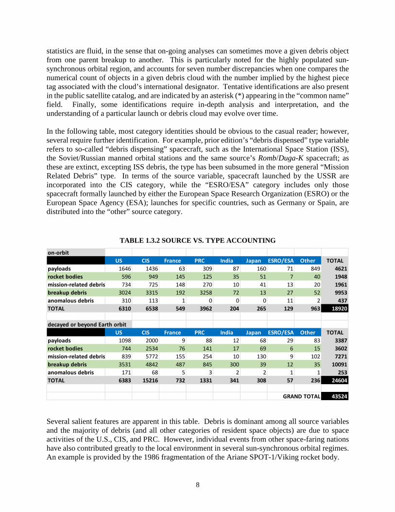
TABLE 1.3.2 SOURCE VS. TYPE ACCOUNTING
Several salient features are apparent in this table. Debris is dominant among all source variables and the majority of debris (and all other categories of resident space objects) are due to space activities of the U.S., CIS, and PRC. However, individual events from other space-faring nations have also contributed greatly to the local environment in several sun-synchronous orbital regimes. An example is provided by the 1986 fragmentation of the Ariane SPOT-1/Viking rocket body.
on-orbitUS CIS France PRC India Japan ESRO/ESA Other TOTAL
payloads 1646 1436 63 309 87 160 71 849 4621rocket bodies 596 949 145 125 35 51 7 40 1948mission-related debris 734 725 148 270 10 41 13 20 1961breakup debris 3024 3315 192 3258 72 13 27 52 9953anomalous debris 310 113 1 0 0 0 11 2 437TOTAL 6310 6538 549 3962 204 265 129 963 18920
decayed or beyond Earth orbitUS CIS France PRC India Japan ESRO/ESA Other TOTAL
payloads 1098 2000 9 88 12 68 29 83 3387rocket bodies 744 2534 76 141 17 69 6 15 3602mission-related debris 839 5772 155 254 10 130 9 102 7271breakup debris 3531 4842 487 845 300 39 12 35 10091anomalous debris 171 68 5 3 2 2 1 1 253TOTAL 6383 15216 732 1331 341 308 57 236 24604
43524GRAND TOTAL
9
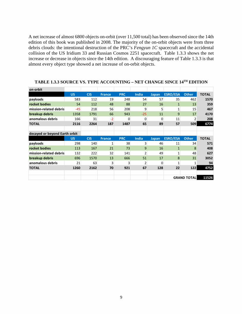
A net increase of almost 6800 objects on-orbit (over 11,500 total) has been observed since the 14th edition of this book was published in 2008. The majority of the on-orbit objects were from three debris clouds: the intentional destruction of the PRC’s Fengyun 1C spacecraft and the accidental collision of the US Iridium 33 and Russian Cosmos 2251 spacecraft. Table 1.3.3 shows the net increase or decrease in objects since the 14th edition. A discouraging feature of Table 1.3.3 is that almost every object type showed a net increase of on-orbit objects.
TABLE 1.3.3 SOURCE VS. TYPE ACCOUNTING – NET CHANGE SINCE 14TH EDITION
on-orbitUS CIS France PRC India Japan ESRO/ESA Other TOTAL
payloads 583 112 19 248 54 57 35 462 1570rocket bodies 54 112 48 88 27 16 1 13 359mission-related debris -45 218 56 208 9 5 1 15 467breakup debris 1358 1791 66 943 -25 11 9 17 4170anomalous debris 166 31 -2 0 0 0 11 2 208TOTAL 2116 2264 187 1487 65 89 57 509 6774
decayed or beyond Earth orbitUS CIS France PRC India Japan ESRO/ESA Other TOTAL
payloads 298 140 1 38 3 46 11 34 571rocket bodies 113 167 21 73 9 16 1 8 408mission-related debris 132 222 32 141 2 49 1 48 627breakup debris 696 1570 13 666 51 17 8 31 3052anomalous debris 21 63 3 3 2 0 1 1 94TOTAL 1260 2162 70 921 67 128 22 122 4752
11526GRAND TOTAL
10
This Page Intentionally Left Blank
11
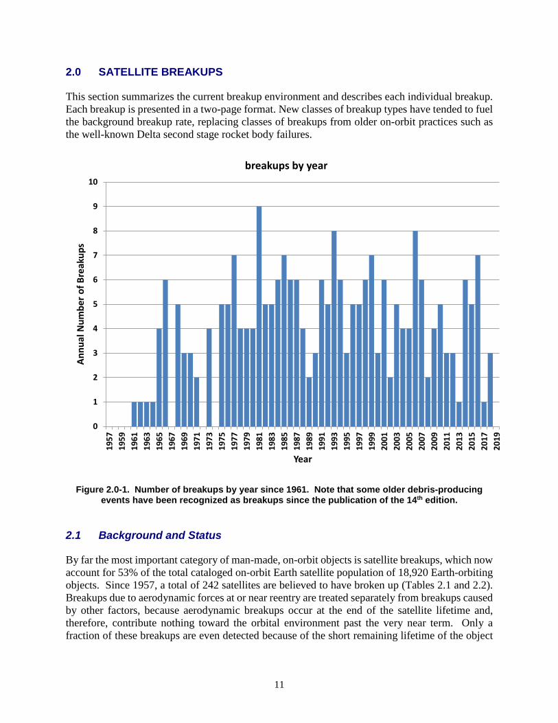
2.0 SATELLITE BREAKUPS This section summarizes the current breakup environment and describes each individual breakup. Each breakup is presented in a two-page format. New classes of breakup types have tended to fuel the background breakup rate, replacing classes of breakups from older on-orbit practices such as the well-known Delta second stage rocket body failures.
Figure 2.0-1. Number of breakups by year since 1961. Note that some older debris-producing events have been recognized as breakups since the publication of the 14th edition.
2.1 Background and Status By far the most important category of man-made, on-orbit objects is satellite breakups, which now account for 53% of the total cataloged on-orbit Earth satellite population of 18,920 Earth-orbiting objects. Since 1957, a total of 242 satellites are believed to have broken up (Tables 2.1 and 2.2). Breakups due to aerodynamic forces at or near reentry are treated separately from breakups caused by other factors, because aerodynamic breakups occur at the end of the satellite lifetime and, therefore, contribute nothing toward the orbital environment past the very near term. Only a fraction of these breakups are even detected because of the short remaining lifetime of the object
0
1
2
3
4
5
6
7
8
9
10
1957
1959
1961
1963
1965
1967
1969
1971
1973
1975
1977
1979
1981
1983
1985
1987
1989
1991
1993
1995
1997
1999
2001
2003
2005
2007
2009
2011
2013
2015
2017
2019
Annu
al N
umbe
r of B
reak
ups
Year
breakups by year
12
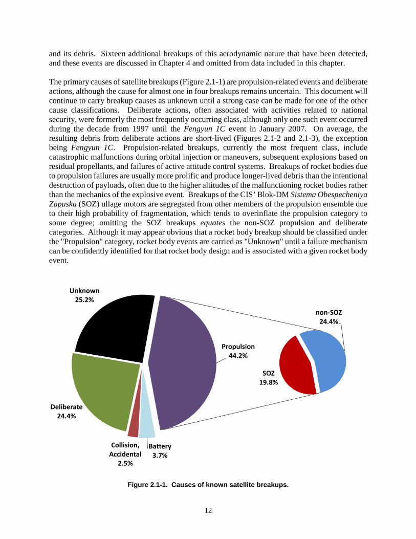
and its debris. Sixteen additional breakups of this aerodynamic nature that have been detected, and these events are discussed in Chapter 4 and omitted from data included in this chapter. The primary causes of satellite breakups (Figure 2.1-1) are propulsion-related events and deliberate actions, although the cause for almost one in four breakups remains uncertain. This document will continue to carry breakup causes as unknown until a strong case can be made for one of the other cause classifications. Deliberate actions, often associated with activities related to national security, were formerly the most frequently occurring class, although only one such event occurred during the decade from 1997 until the Fengyun 1C event in January 2007. On average, the resulting debris from deliberate actions are short-lived (Figures 2.1-2 and 2.1-3), the exception being Fengyun 1C. Propulsion-related breakups, currently the most frequent class, include catastrophic malfunctions during orbital injection or maneuvers, subsequent explosions based on residual propellants, and failures of active attitude control systems. Breakups of rocket bodies due to propulsion failures are usually more prolific and produce longer-lived debris than the intentional destruction of payloads, often due to the higher altitudes of the malfunctioning rocket bodies rather than the mechanics of the explosive event. Breakups of the CIS’ Blok-DM Sistema Obespecheniya Zapuska (SOZ) ullage motors are segregated from other members of the propulsion ensemble due to their high probability of fragmentation, which tends to overinflate the propulsion category to some degree; omitting the SOZ breakups equates the non-SOZ propulsion and deliberate categories. Although it may appear obvious that a rocket body breakup should be classified under the "Propulsion" category, rocket body events are carried as "Unknown" until a failure mechanism can be confidently identified for that rocket body design and is associated with a given rocket body event.
Figure 2.1-1. Causes of known satellite breakups.
Battery3.7%
Collision, Accidental
2.5%
Deliberate24.4%
Unknown25.2%
SOZ19.8%
non-SOZ 24.4%
Propulsion44.2%

13
Figure 2.1-2. Proportion of all cataloged satellite breakup debris.
Figure 2.1-3. Proportion of cataloged satellite breakup debris remaining in orbit.
The rate of satellite breakups increased noticeably in the 1970s and has continued through the 1990s and into the new millennium at an average pace of approximately four fragmentations per year since 2001. The recent low-activity years of 2013 and 2017 appear as statistical anomalies in
Battery5.4% Collisions,
accidental11.6%
Deliberate30.5%
Propulsion34.7%
Unknown17.8%
Battery8.7%
Collisions, accidental
14.3%
Deliberate32.7%
Propulsion30.5%
Unknown13.8%
14
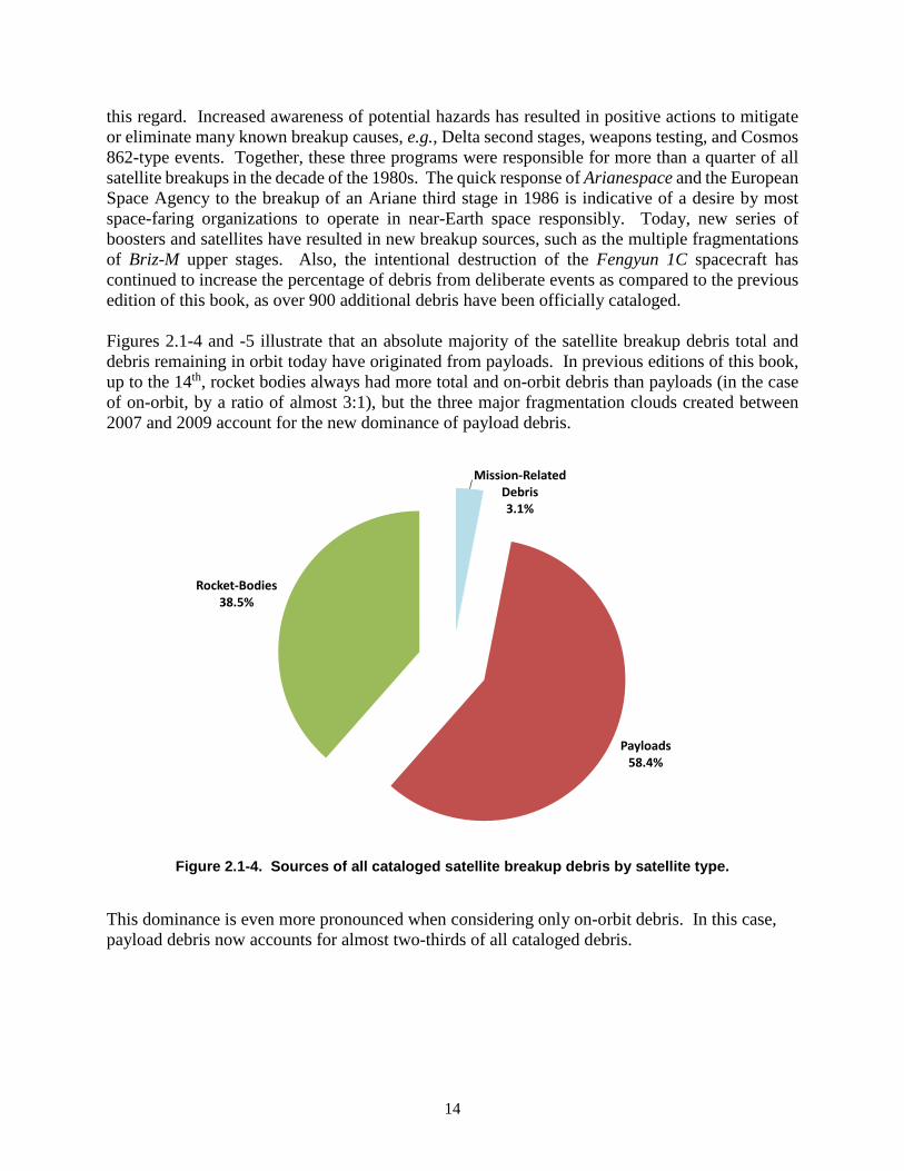
this regard. Increased awareness of potential hazards has resulted in positive actions to mitigate or eliminate many known breakup causes, e.g., Delta second stages, weapons testing, and Cosmos 862-type events. Together, these three programs were responsible for more than a quarter of all satellite breakups in the decade of the 1980s. The quick response of Arianespace and the European Space Agency to the breakup of an Ariane third stage in 1986 is indicative of a desire by most space-faring organizations to operate in near-Earth space responsibly. Today, new series of boosters and satellites have resulted in new breakup sources, such as the multiple fragmentations of Briz-M upper stages. Also, the intentional destruction of the Fengyun 1C spacecraft has continued to increase the percentage of debris from deliberate events as compared to the previous edition of this book, as over 900 additional debris have been officially cataloged. Figures 2.1-4 and -5 illustrate that an absolute majority of the satellite breakup debris total and debris remaining in orbit today have originated from payloads. In previous editions of this book, up to the 14th, rocket bodies always had more total and on-orbit debris than payloads (in the case of on-orbit, by a ratio of almost 3:1), but the three major fragmentation clouds created between 2007 and 2009 account for the new dominance of payload debris.
Figure 2.1-4. Sources of all cataloged satellite breakup debris by satellite type.
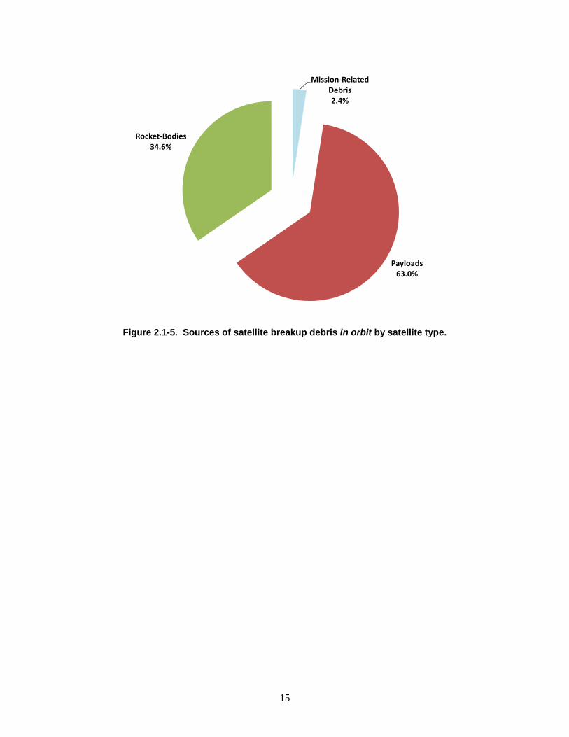
This dominance is even more pronounced when considering only on-orbit debris. In this case, payload debris now accounts for almost two-thirds of all cataloged debris.
Mission-Related Debris3.1%
Payloads58.4%
Rocket-Bodies38.5%
15
Figure 2.1-5. Sources of satellite breakup debris in orbit by satellite type.
Mission-Related Debris2.4%
Payloads63.0%
Rocket-Bodies34.6%
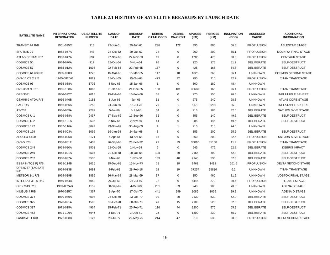
TABLE 2.1 HISTORY OF SATELLITE BREAKUPS BY LAUNCH DATE
16
SATELLITE NAME INTERNATIONAL DESIGNATOR
US SATELLITE NUMBER
LAUNCH DATE
BREAKUP DATE
DEBRIS CATALOGED
DEBRIS ON-ORBIT
APOGEE (KM)
PERIGEE (KM)
INCLINATION (DEG)
ASSESSED CAUSE
ADDITIONAL INFORMATION
TRANSIT 4A R/B 1961-015C 118 29-Jun-61 29-Jun-61 296 172 995 880 66.8 PROPULSION ABLESTAR STAGE
SPUTNIK 29 1962-057A 443 24-Oct-62 29-Oct-62 24 0 260 200 65.1 PROPULSION MOLNIYA FINAL STAGE
ATLAS CENTAUR 2 1963-047A 694 27-Nov-63 27-Nov-63 19 8 1785 475 30.3 PROPULSION CENTAUR STAGE
COSMOS 50 1964-070A 919 28-Oct-64 5-Nov-64 96 0 220 175 51.2 DELIBERATE SELF-DESTRUCT
COSMOS 57 1965-012A 1093 22-Feb-65 22-Feb-65 167 0 425 165 64.8 DELIBERATE SELF-DESTRUCT
COSMOS 61-63 R/B 1965-020D 1270 15-Mar-65 15-Mar-65 147 18 1825 260 56.1 UNKNOWN COSMOS SECOND STAGE
OV2-1/LCS 2 R/B 1965-082DM 1822 15-Oct-65 15-Oct-65 473 32 790 710 32.2 PROPULSION TITAN TRANSTAGE
COSMOS 95 1965-088A 1706 4-Nov-65 15-Jan-66 1 0 300 180 48.4 UNKNOWN
OV2-3/ et al. R/B 1965-108A 1863 21-Dec-65 21-Dec-65 108 101 33660 165 26.4 PROPULSION TITAN TRANSTAGE
OPS 3031 1966-012C 2015 15-Feb-66 15-Feb-66 38 0 270 150 96.5 UNKNOWN INFLATABLE SPHERE
GEMINI 9 ATDA R/B 1966-046B 2188 1-Jun-66 Jun-66 51 0 275 240 28.8 UNKNOWN ATLAS CORE STAGE
PAGEOS 1966-056A 2253 24-Jun-66 12-Jul-75 79 1 5170 3200 85.3 UNKNOWN INFLATABLE SPHERE
AS-203 1966-059A 2289 5-Jul-66 5-Jul-66 34 0 215 185 32.0 DELIBERATE SATURN S-IVB STAGE
COSMOS U-1 1966-088A 2437 17-Sep-66 17-Sep-66 52 0 855 140 49.6 DELIBERATE SELF-DESTRUCT
COSMOS U-2 1966-101A 2536 2-Nov-66 2-Nov-66 41 0 885 145 49.6 DELIBERATE SELF-DESTRUCT
COSMOS 192 1967-116A 3047 23-Nov-67 30-Aug-09 4 1 715 710 74.0 UNKNOWN
COSMOS 199 1968-003A 3099 16-Jan-68 24-Jan-68 3 0 355 200 65.6 DELIBERATE SELF-DESTRUCT
APOLLO 6 R/B 1968-025B 3171 4-Apr-68 13-Apr-68 16 0 360 200 32.6 PROPULSION SATURN S-IVB STAGE
OV2-5 R/B 1968-081E 3432 26-Sep-68 21-Feb-92 29 29 35810 35100 11.9 PROPULSION TITAN TRANSTAGE
COSMOS 248 1968-090A 3503 19-Oct-68 1-Nov-68 5 0 545 475 62.2 DELIBERATE DEBRIS IMPACT
COSMOS 249 1968-091A 3504 20-Oct-68 20-Oct-68 108 39 2165 490 62.3 DELIBERATE SELF-DESTRUCT
COSMOS 252 1968-097A 3530 1-Nov-68 1-Nov-68 139 40 2140 535 62.3 DELIBERATE SELF-DESTRUCT
ESSA 8 (TOS F) R/B 1968-114B 3616 15-Dec-68 15-Nov-73 18 18 1462 1413 101.6 PROPULSION DELTA SECOND STAGE OPS 0757 (TACSAT) R/B 1969-013B 3692 9-Feb-69 28-Feb-18 19 19 37257 35886 6.2 UNKNOWN TITAN TRANSTAGE
METEOR 1-1 R/B 1969-029B 3836 26-Mar-69 28-Mar-69 37 0 850 460 81.2 UNKNOWN VOSTOK FINAL STAGE
INTELSAT 3 F-5 R/B 1969-064B 4052 26-Jul-69 26-Jul-69 22 0 5445 270 30.4 PROPULSION TE 364-4 STAGE
OPS 7613 R/B 1969-082AB 4159 30-Sep-69 4-Oct-69 261 63 940 905 70.0 UNKNOWN AGENA D STAGE
NIMBUS 4 R/B 1970-025C 4367 8-Apr-70 17-Oct-70 441 299 1085 1065 99.9 UNKNOWN AGENA D STAGE
COSMOS 374 1970-089A 4594 23-Oct-70 23-Oct-70 99 20 2130 530 62.9 DELIBERATE SELF-DESTRUCT
COSMOS 375 1970-091A 4598 30-Oct-70 30-Oct-70 47 15 2100 525 62.8 DELIBERATE SELF-DESTRUCT
COSMOS 397 1971-015A 4964 25-Feb-71 25-Feb-71 116 44 2200 575 65.8 DELIBERATE SELF-DESTRUCT
COSMOS 462 1971-106A 5646 3-Dec-71 3-Dec-71 25 0 1800 230 65.7 DELIBERATE SELF-DESTRUCT
LANDSAT 1 R/B 1972-058B 6127 23-Jul-72 22-May-75 244 47 910 635 98.3 PROPULSION DELTA SECOND STAGE

TABLE 2.1 HISTORY OF SATELLITE BREAKUPS BY LAUNCH DATE (CONT’D)
17
SATELLITE NAME INTERNATIONAL DESIGNATOR
US SATELLITE NUMBER
LAUNCH DATE
BREAKUP DATE
DEBRIS CATALOGED
DEBRIS ON-ORBIT
APOGEE (KM)
PERIGEE (KM)
INCLINATION (DEG)
ASSESSED CAUSE
ADDITIONAL INFORMATION
SALYUT 2 R/B 1973-017B 6399 3-Apr-73 3-Apr-73 25 0 245 195 51.5 PROPULSION PROTON-K THIRD STAGE
COSMOS 554 1973-021A 6432 19-Apr-73 6-May-73 193 0 350 170 72.9 DELIBERATE SELF-DESTRUCT
NOAA 3 R/B 1973-086B 6921 6-Nov-73 28-Dec-73 220 198 1510 1500 102.1 PROPULSION DELTA SECOND STAGE
DMSP 5B F5 R/B 1974-015B 7219 16-Mar-74 17-Jan-05 7 7 885 775 99.1 COLLISION, ACCIDENTAL HIT BY DEBRIS (26207)
NOAA 4 R/B 1974-089D 7532 15-Nov-74 20-Aug-75 185 160 1460 1445 101.7 PROPULSION DELTA SECOND STAGE
COSMOS 699 1974-103A 7587 24-Dec-74 17-Apr-75 50 0 445 425 65.0 UNKNOWN COSMOS 699 CLASS
LANDSAT 2 R/B 1975-004B 7616 22-Jan-75 9-Feb-76 207 32 915 740 97.8 PROPULSION DELTA SECOND STAGE
NIMBUS 6 R/B 1975-052B 7946 12-Jun-75 1-May-91 307 231 1105 1095 99.6 PROPULSION DELTA SECOND STAGE
COSMOS 758 1975-080A 8191 5-Sep-75 6-Sep-75 76 0 325 175 67.1 DELIBERATE SELF-DESTRUCT
COSMOS 777 1975-102A 8416 29-Oct-75 25-Jan-76 62 0 440 430 65.0 UNKNOWN COSMOS 699 CLASS
COSMOS 838 1976-063A 8932 2-Jul-76 17-May-77 40 0 445 415 65.1 UNKNOWN COSMOS 699 CLASS
COSMOS 839 1976-067A 9011 8-Jul-76 29-Sep-77 70 68 2100 980 65.9 BATTERY
COSMOS 844 1976-072A 9046 22-Jul-76 25-Jul-76 248 0 355 170 67.1 DELIBERATE SELF-DESTRUCT
NOAA 5 R/B 1976-077B 9063 29-Jul-76 24-Dec-77 184 174 1520 1505 102.0 PROPULSION DELTA SECOND STAGE
COSMOS 862 1976-105A 9495 22-Oct-76 15-Mar-77 13 5 39645 765 63.2 DELIBERATE SELF-DESTRUCT
COSMOS 880 1976-120A 9601 9-Dec-76 27-Nov-78 49 0 620 550 65.8 BATTERY
COSMOS 884 1976-123A 9614 17-Dec-76 29-Dec-76 2 0 320 170 65.0 DELIBERATE SELF-DESTRUCT
COSMOS 886 1976-126A 9634 27-Dec-76 27-Dec-76 76 58 2295 595 65.8 DELIBERATE SELF-DESTRUCT
COSMOS 903 1977-027A 9911 11-Apr-77 8-Jun-78 6 3 39035 1325 63.2 DELIBERATE SELF-DESTRUCT
COSMOS 917 1977-047A 10059 16-Jun-77 30-Mar-79 14 12 38725 1645 62.9 DELIBERATE SELF-DESTRUCT
HIMAWARI 1 R/B 1977-065B 10144 14-Jul-77 14-Jul-77 177 59 2025 535 29.0 PROPULSION DELTA SECOND STAGE
COSMOS 931 1977-068A 10150 20-Jul-77 24-Oct-77 6 5 39665 680 62.9 DELIBERATE SELF-DESTRUCT
EKRAN 2 1977-092A 10365 20-Sep-77 23-Jun-78 5 5 35800 35785 0.1 BATTERY
COSMOS 970 1977-121A 10531 21-Dec-77 21-Dec-77 70 64 1140 945 65.8 DELIBERATE SELF-DESTRUCT
LANDSAT 3 R/B 1978-026C 10704 5-Mar-78 27-Jan-81 248 153 910 900 98.8 PROPULSION DELTA SECOND STAGE
COSMOS 1030 1978-083A 11015 6-Sep-78 10-Oct-78 13 9 39760 665 62.8 DELIBERATE SELF-DESTRUCT
NIMBUS 7 R/B 1978-098B 11081 24-Oct-78 26-Dec-81 2 1 955 935 99.3 PROPULSION DELTA SECOND STAGE
COSMOS 1045 R/B 1978-100D 11087 26-Oct-78 9-May-88 42 32 1705 1685 82.6 PROPULSION TSYKLON THIRD STAGE
P-78/SOLWIND 1979-017A 11278 24-Feb-79 13-Sep-85 285 0 545 515 97.6 COLLISION, DELIBERATE HYPERVELOCITY IMPACT
COSMOS 1094 1979-033A 11333 18-Apr-79 17-Sep-79 1 0 405 380 65.0 UNKNOWN COSMOS 699 CLASS
COSMOS 1109 1979-058A 11417 27-Jun-79 Feb-80 19 8 39425 960 63.3 DELIBERATE SELF-DESTRUCT
COSMOS 1124 1979-077A 11509 28-Aug-79 9-Sep-79 5 5 39795 570 63.0 DELIBERATE SELF-DESTRUCT
SATCOM 3 1979-101A 11635 7-Dec-79 11-Dec-79 21 21 35776 204 23.7 PROPULSION AKM FAILURE
CAT R/B 1979-104B 11659 24-Dec-79 Apr-80 31 24 33140 180 17.9 PROPULSION ARIANE 1 FINAL STAGE
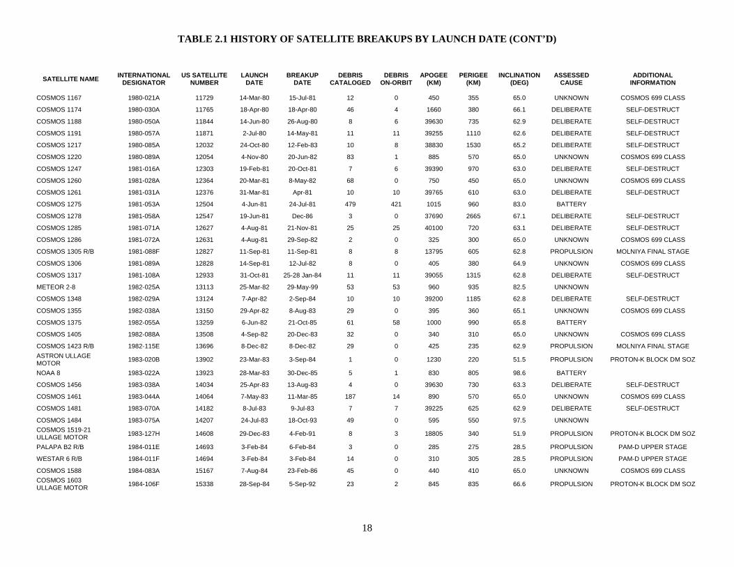
TABLE 2.1 HISTORY OF SATELLITE BREAKUPS BY LAUNCH DATE (CONT’D)
18
SATELLITE NAME INTERNATIONAL DESIGNATOR
US SATELLITE NUMBER
LAUNCH DATE
BREAKUP DATE
DEBRIS CATALOGED
DEBRIS ON-ORBIT
APOGEE (KM)
PERIGEE (KM)
INCLINATION (DEG)
ASSESSED CAUSE
ADDITIONAL INFORMATION
COSMOS 1167 1980-021A 11729 14-Mar-80 15-Jul-81 12 0 450 355 65.0 UNKNOWN COSMOS 699 CLASS
COSMOS 1174 1980-030A 11765 18-Apr-80 18-Apr-80 46 4 1660 380 66.1 DELIBERATE SELF-DESTRUCT
COSMOS 1188 1980-050A 11844 14-Jun-80 26-Aug-80 8 6 39630 735 62.9 DELIBERATE SELF-DESTRUCT
COSMOS 1191 1980-057A 11871 2-Jul-80 14-May-81 11 11 39255 1110 62.6 DELIBERATE SELF-DESTRUCT
COSMOS 1217 1980-085A 12032 24-Oct-80 12-Feb-83 10 8 38830 1530 65.2 DELIBERATE SELF-DESTRUCT
COSMOS 1220 1980-089A 12054 4-Nov-80 20-Jun-82 83 1 885 570 65.0 UNKNOWN COSMOS 699 CLASS
COSMOS 1247 1981-016A 12303 19-Feb-81 20-Oct-81 7 6 39390 970 63.0 DELIBERATE SELF-DESTRUCT
COSMOS 1260 1981-028A 12364 20-Mar-81 8-May-82 68 0 750 450 65.0 UNKNOWN COSMOS 699 CLASS
COSMOS 1261 1981-031A 12376 31-Mar-81 Apr-81 10 10 39765 610 63.0 DELIBERATE SELF-DESTRUCT
COSMOS 1275 1981-053A 12504 4-Jun-81 24-Jul-81 479 421 1015 960 83.0 BATTERY
COSMOS 1278 1981-058A 12547 19-Jun-81 Dec-86 3 0 37690 2665 67.1 DELIBERATE SELF-DESTRUCT
COSMOS 1285 1981-071A 12627 4-Aug-81 21-Nov-81 25 25 40100 720 63.1 DELIBERATE SELF-DESTRUCT
COSMOS 1286 1981-072A 12631 4-Aug-81 29-Sep-82 2 0 325 300 65.0 UNKNOWN COSMOS 699 CLASS
COSMOS 1305 R/B 1981-088F 12827 11-Sep-81 11-Sep-81 8 8 13795 605 62.8 PROPULSION MOLNIYA FINAL STAGE
COSMOS 1306 1981-089A 12828 14-Sep-81 12-Jul-82 8 0 405 380 64.9 UNKNOWN COSMOS 699 CLASS
COSMOS 1317 1981-108A 12933 31-Oct-81 25-28 Jan-84 11 11 39055 1315 62.8 DELIBERATE SELF-DESTRUCT
METEOR 2-8 1982-025A 13113 25-Mar-82 29-May-99 53 53 960 935 82.5 UNKNOWN
COSMOS 1348 1982-029A 13124 7-Apr-82 2-Sep-84 10 10 39200 1185 62.8 DELIBERATE SELF-DESTRUCT
COSMOS 1355 1982-038A 13150 29-Apr-82 8-Aug-83 29 0 395 360 65.1 UNKNOWN COSMOS 699 CLASS
COSMOS 1375 1982-055A 13259 6-Jun-82 21-Oct-85 61 58 1000 990 65.8 BATTERY
COSMOS 1405 1982-088A 13508 4-Sep-82 20-Dec-83 32 0 340 310 65.0 UNKNOWN COSMOS 699 CLASS
COSMOS 1423 R/B 1982-115E 13696 8-Dec-82 8-Dec-82 29 0 425 235 62.9 PROPULSION MOLNIYA FINAL STAGE ASTRON ULLAGE MOTOR 1983-020B 13902 23-Mar-83 3-Sep-84 1 0 1230 220 51.5 PROPULSION PROTON-K BLOCK DM SOZ
NOAA 8 1983-022A 13923 28-Mar-83 30-Dec-85 5 1 830 805 98.6 BATTERY
COSMOS 1456 1983-038A 14034 25-Apr-83 13-Aug-83 4 0 39630 730 63.3 DELIBERATE SELF-DESTRUCT
COSMOS 1461 1983-044A 14064 7-May-83 11-Mar-85 187 14 890 570 65.0 UNKNOWN COSMOS 699 CLASS
COSMOS 1481 1983-070A 14182 8-Jul-83 9-Jul-83 7 7 39225 625 62.9 DELIBERATE SELF-DESTRUCT
COSMOS 1484 1983-075A 14207 24-Jul-83 18-Oct-93 49 0 595 550 97.5 UNKNOWN
COSMOS 1519-21 ULLAGE MOTOR 1983-127H 14608 29-Dec-83 4-Feb-91 8 3 18805 340 51.9 PROPULSION PROTON-K BLOCK DM SOZ
PALAPA B2 R/B 1984-011E 14693 3-Feb-84 6-Feb-84 3 0 285 275 28.5 PROPULSION PAM-D UPPER STAGE
WESTAR 6 R/B 1984-011F 14694 3-Feb-84 3-Feb-84 14 0 310 305 28.5 PROPULSION PAM-D UPPER STAGE
COSMOS 1588 1984-083A 15167 7-Aug-84 23-Feb-86 45 0 440 410 65.0 UNKNOWN COSMOS 699 CLASS COSMOS 1603 ULLAGE MOTOR 1984-106F 15338 28-Sep-84 5-Sep-92 23 2 845 835 66.6 PROPULSION PROTON-K BLOCK DM SOZ
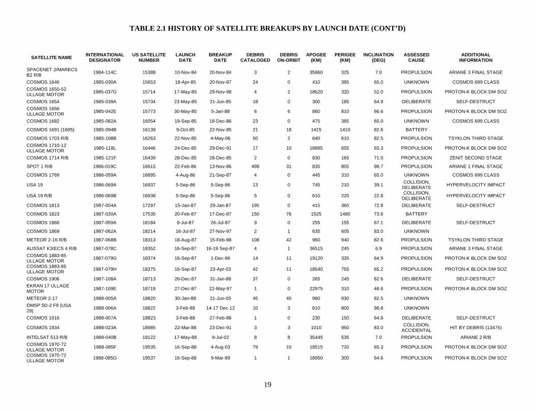
TABLE 2.1 HISTORY OF SATELLITE BREAKUPS BY LAUNCH DATE (CONT’D)
19
SATELLITE NAME INTERNATIONAL DESIGNATOR
US SATELLITE NUMBER
LAUNCH DATE
BREAKUP DATE
DEBRIS CATALOGED
DEBRIS ON-ORBIT
APOGEE (KM)
PERIGEE (KM)
INCLINATION (DEG)
ASSESSED CAUSE
ADDITIONAL INFORMATION
SPACENET 2/MARECS B2 R/B 1984-114C 15388 10-Nov-84 20-Nov-84 3 2 35960 325 7.0 PROPULSION ARIANE 3 FINAL STAGE
COSMOS 1646 1985-030A 15653 18-Apr-85 20-Nov-87 24 0 410 385 65.0 UNKNOWN COSMOS 699 CLASS COSMOS 1650-52 ULLAGE MOTOR 1985-037G 15714 17-May-85 29-Nov-98 4 2 18620 320 52.0 PROPULSION PROTON-K BLOCK DM SOZ
COSMOS 1654 1985-039A 15734 23-May-85 21-Jun-85 18 0 300 185 64.9 DELIBERATE SELF-DESTRUCT COSMOS 1656 ULLAGE MOTOR 1985-042E 15773 30-May-85 5-Jan-88 6 6 860 810 66.6 PROPULSION PROTON-K BLOCK DM SOZ
COSMOS 1682 1985-082A 16054 19-Sep-85 18-Dec-86 23 0 475 385 65.0 UNKNOWN COSMOS 699 CLASS
COSMOS 1691 (1695) 1985-094B 16139 9-Oct-85 22-Nov-85 21 18 1415 1410 82.6 BATTERY
COSMOS 1703 R/B 1985-108B 16263 22-Nov-85 4-May-06 50 2 640 610 82.5 PROPULSION TSYKLON THIRD STAGE COSMOS 1710-12 ULLAGE MOTOR 1985-118L 16446 24-Dec-85 29-Dec-91 17 10 18885 655 65.3 PROPULSION PROTON-K BLOCK DM SOZ
COSMOS 1714 R/B 1985-121F 16439 28-Dec-85 28-Dec-85 2 0 830 165 71.0 PROPULSION ZENIT SECOND STAGE
SPOT 1 R/B 1986-019C 16615 22-Feb-86 13-Nov-86 498 31 835 805 98.7 PROPULSION ARIANE 1 FINAL STAGE
COSMOS 1769 1986-059A 16895 4-Aug-86 21-Sep-87 4 0 445 310 65.0 UNKNOWN COSMOS 699 CLASS
USA 19 1986-069A 16937 5-Sep-86 5-Sep-86 13 0 745 210 39.1 COLLISION, DELIBERATE HYPERVELOCITY IMPACT
USA 19 R/B 1986-069B 16938 5-Sep-86 5-Sep-86 5 0 610 220 22.8 COLLISION, DELIBERATE HYPERVELOCITY IMPACT
COSMOS 1813 1987-004A 17297 15-Jan-87 29-Jan-87 195 0 415 360 72.8 DELIBERATE SELF-DESTRUCT
COSMOS 1823 1987-020A 17535 20-Feb-87 17-Dec-87 150 76 1525 1480 73.6 BATTERY
COSMOS 1866 1987-059A 18184 9-Jul-87 26-Jul-87 9 0 255 155 67.1 DELIBERATE SELF-DESTRUCT
COSMOS 1869 1987-062A 18214 16-Jul-87 27-Nov-97 2 1 635 605 83.0 UNKNOWN
METEOR 2-16 R/B 1987-068B 18313 18-Aug-87 15-Feb-98 108 42 960 940 82.6 PROPULSION TSYKLON THIRD STAGE
AUSSAT K3/ECS 4 R/B 1987-078C 18352 16-Sep-87 16-19 Sep-87 4 1 36515 245 6.9 PROPULSION ARIANE 3 FINAL STAGE COSMOS 1883-85 ULLAGE MOTOR 1987-079G 18374 16-Sep-87 1-Dec-96 14 11 19120 335 64.9 PROPULSION PROTON-K BLOCK DM SOZ
COSMOS 1883-85 ULLAGE MOTOR 1987-079H 18375 16-Sep-87 23-Apr-03 42 11 18540 755 65.2 PROPULSION PROTON-K BLOCK DM SOZ
COSMOS 1906 1987-108A 18713 26-Dec-87 31-Jan-88 37 0 265 245 82.6 DELIBERATE SELF-DESTRUCT EKRAN 17 ULLAGE MOTOR 1987-109E 18719 27-Dec-87 22-May-97 1 0 22975 310 46.6 PROPULSION PROTON-K BLOCK DM SOZ
METEOR 2-17 1988-005A 18820 30-Jan-88 21-Jun-05 45 45 960 930 82.5 UNKNOWN
DMSP 5D-2 F9 (USA 29) 1988-006A 18822 3-Feb-88 14-17 Dec-12 10 3 810 800 98.8 UNKNOWN
COSMOS 1916 1988-007A 18823 3-Feb-88 27-Feb-88 1 0 230 150 64.8 DELIBERATE SELF-DESTRUCT
COSMOS 1934 1988-023A 18985 22-Mar-88 23-Dec-91 3 3 1010 950 83.0 COLLISION, ACCIDENTAL HIT BY DEBRIS (13475)
INTELSAT 513 R/B 1988-040B 19122 17-May-88 9-Jul-02 8 8 35445 535 7.0 PROPULSION ARIANE 2 R/B COSMOS 1970-72 ULLAGE MOTOR 1988-085F 19535 16-Sep-88 4-Aug-03 79 10 18515 720 65.3 PROPULSION PROTON-K BLOCK DM SOZ
COSMOS 1970-72 ULLAGE MOTOR 1988-085G 19537 16-Sep-88 9-Mar-99 1 1 18950 300 64.6 PROPULSION PROTON-K BLOCK DM SOZ
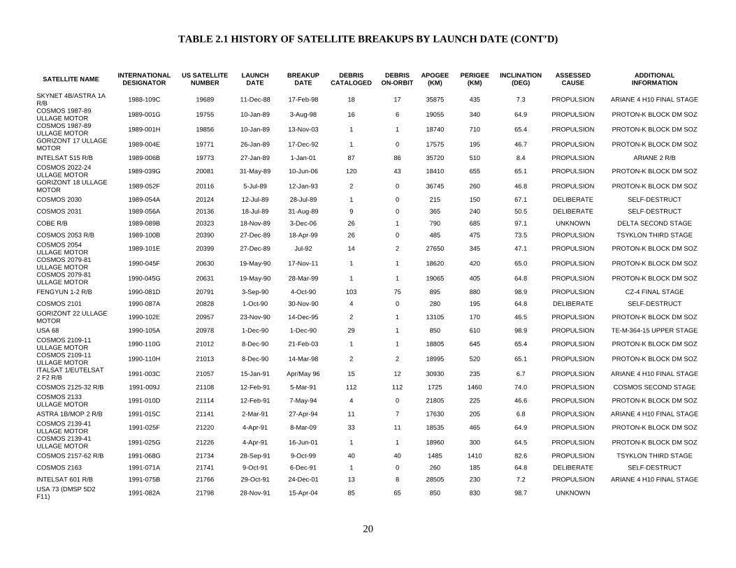
TABLE 2.1 HISTORY OF SATELLITE BREAKUPS BY LAUNCH DATE (CONT’D)
20
SATELLITE NAME INTERNATIONAL DESIGNATOR
US SATELLITE NUMBER
LAUNCH DATE
BREAKUP DATE
DEBRIS CATALOGED
DEBRIS ON-ORBIT
APOGEE (KM)
PERIGEE (KM)
INCLINATION (DEG)
ASSESSED CAUSE
ADDITIONAL INFORMATION
SKYNET 4B/ASTRA 1A R/B 1988-109C 19689 11-Dec-88 17-Feb-98 18 17 35875 435 7.3 PROPULSION ARIANE 4 H10 FINAL STAGE
COSMOS 1987-89 ULLAGE MOTOR 1989-001G 19755 10-Jan-89 3-Aug-98 16 6 19055 340 64.9 PROPULSION PROTON-K BLOCK DM SOZ
COSMOS 1987-89 ULLAGE MOTOR 1989-001H 19856 10-Jan-89 13-Nov-03 1 1 18740 710 65.4 PROPULSION PROTON-K BLOCK DM SOZ
GORIZONT 17 ULLAGE MOTOR 1989-004E 19771 26-Jan-89 17-Dec-92 1 0 17575 195 46.7 PROPULSION PROTON-K BLOCK DM SOZ
INTELSAT 515 R/B 1989-006B 19773 27-Jan-89 1-Jan-01 87 86 35720 510 8.4 PROPULSION ARIANE 2 R/B COSMOS 2022-24 ULLAGE MOTOR 1989-039G 20081 31-May-89 10-Jun-06 120 43 18410 655 65.1 PROPULSION PROTON-K BLOCK DM SOZ
GORIZONT 18 ULLAGE MOTOR 1989-052F 20116 5-Jul-89 12-Jan-93 2 0 36745 260 46.8 PROPULSION PROTON-K BLOCK DM SOZ
COSMOS 2030 1989-054A 20124 12-Jul-89 28-Jul-89 1 0 215 150 67.1 DELIBERATE SELF-DESTRUCT
COSMOS 2031 1989-056A 20136 18-Jul-89 31-Aug-89 9 0 365 240 50.5 DELIBERATE SELF-DESTRUCT
COBE R/B 1989-089B 20323 18-Nov-89 3-Dec-06 26 1 790 685 97.1 UNKNOWN DELTA SECOND STAGE
COSMOS 2053 R/B 1989-100B 20390 27-Dec-89 18-Apr-99 26 0 485 475 73.5 PROPULSION TSYKLON THIRD STAGE COSMOS 2054 ULLAGE MOTOR 1989-101E 20399 27-Dec-89 Jul-92 14 2 27650 345 47.1 PROPULSION PROTON-K BLOCK DM SOZ
COSMOS 2079-81 ULLAGE MOTOR 1990-045F 20630 19-May-90 17-Nov-11 1 1 18620 420 65.0 PROPULSION PROTON-K BLOCK DM SOZ
COSMOS 2079-81 ULLAGE MOTOR 1990-045G 20631 19-May-90 28-Mar-99 1 1 19065 405 64.8 PROPULSION PROTON-K BLOCK DM SOZ
FENGYUN 1-2 R/B 1990-081D 20791 3-Sep-90 4-Oct-90 103 75 895 880 98.9 PROPULSION CZ-4 FINAL STAGE
COSMOS 2101 1990-087A 20828 1-Oct-90 30-Nov-90 4 0 280 195 64.8 DELIBERATE SELF-DESTRUCT GORIZONT 22 ULLAGE MOTOR 1990-102E 20957 23-Nov-90 14-Dec-95 2 1 13105 170 46.5 PROPULSION PROTON-K BLOCK DM SOZ
USA 68 1990-105A 20978 1-Dec-90 1-Dec-90 29 1 850 610 98.9 PROPULSION TE-M-364-15 UPPER STAGE COSMOS 2109-11 ULLAGE MOTOR 1990-110G 21012 8-Dec-90 21-Feb-03 1 1 18805 645 65.4 PROPULSION PROTON-K BLOCK DM SOZ
COSMOS 2109-11 ULLAGE MOTOR 1990-110H 21013 8-Dec-90 14-Mar-98 2 2 18995 520 65.1 PROPULSION PROTON-K BLOCK DM SOZ
ITALSAT 1/EUTELSAT 2 F2 R/B 1991-003C 21057 15-Jan-91 Apr/May 96 15 12 30930 235 6.7 PROPULSION ARIANE 4 H10 FINAL STAGE
COSMOS 2125-32 R/B 1991-009J 21108 12-Feb-91 5-Mar-91 112 112 1725 1460 74.0 PROPULSION COSMOS SECOND STAGE COSMOS 2133 ULLAGE MOTOR 1991-010D 21114 12-Feb-91 7-May-94 4 0 21805 225 46.6 PROPULSION PROTON-K BLOCK DM SOZ
ASTRA 1B/MOP 2 R/B 1991-015C 21141 2-Mar-91 27-Apr-94 11 7 17630 205 6.8 PROPULSION ARIANE 4 H10 FINAL STAGE COSMOS 2139-41 ULLAGE MOTOR 1991-025F 21220 4-Apr-91 8-Mar-09 33 11 18535 465 64.9 PROPULSION PROTON-K BLOCK DM SOZ
COSMOS 2139-41 ULLAGE MOTOR 1991-025G 21226 4-Apr-91 16-Jun-01 1 1 18960 300 64.5 PROPULSION PROTON-K BLOCK DM SOZ
COSMOS 2157-62 R/B 1991-068G 21734 28-Sep-91 9-Oct-99 40 40 1485 1410 82.6 PROPULSION TSYKLON THIRD STAGE
COSMOS 2163 1991-071A 21741 9-Oct-91 6-Dec-91 1 0 260 185 64.8 DELIBERATE SELF-DESTRUCT
INTELSAT 601 R/B 1991-075B 21766 29-Oct-91 24-Dec-01 13 8 28505 230 7.2 PROPULSION ARIANE 4 H10 FINAL STAGE USA 73 (DMSP 5D2 F11) 1991-082A 21798 28-Nov-91 15-Apr-04 85 65 850 830 98.7 UNKNOWN
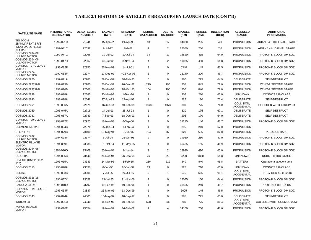
TABLE 2.1 HISTORY OF SATELLITE BREAKUPS BY LAUNCH DATE (CONT’D)
21
SATELLITE NAME INTERNATIONAL DESIGNATOR
US SATELLITE NUMBER
LAUNCH DATE
BREAKUP DATE
DEBRIS CATALOGED
DEBRIS ON-ORBIT
APOGEE (KM)
PERIGEE (KM)
INCLINATION (DEG)
ASSESSED CAUSE
ADDITIONAL INFORMATION
TELECOM 2B/INMARSAT 2 R/B 1992-021C 21941 15-Apr-92 21-Apr-93 18 17 34080 235 4.0 PROPULSION ARIANE 4 H10+ FINAL STAGE
INSAT 2A/EUTELSAT 2F4 R/B 1992-041C 22032 9-Jul-92 Feb-02 2 2 26550 250 7.0 PROPULSION ARIANE 4 H10 FINAL STAGE
COSMOS 2204-06 ULLAGE MOTOR 1992-047G 22066 30-Jul-92 10-Jul-04 34 12 18820 415 64.9 PROPULSION PROTON-K BLOCK DM SOZ
COSMOS 2204-06 ULLAGE MOTOR 1992-047H 22067 30-Jul-92 8-Nov-94 4 2 19035 480 64.8 PROPULSION PROTON-K BLOCK DM SOZ
GORIZONT 27 ULLAGE MOTOR 1992-082F 22250 27-Nov-92 14-Jul-01 1 0 5340 145 46.5 PROPULSION PROTON-K BLOCK DM SOZ
COSMOS 2224 ULLAGE MOTOR 1992-088F 22274 17-Dec-92 ~22-Apr-05 1 0 21140 200 46.7 PROPULSION PROTON-K BLOCK DM SOZ
COSMOS 2225 1992-091A 22280 22-Dec-92 18-Feb-93 6 0 280 225 64.9 DELIBERATE SELF-DESTRUCT
COSMOS 2227 R/B 1992-093B 22285 25-Dec-92 26-Dec-92 279 196 855 845 71.0 PROPULSION ZENIT-2 SECOND STAGE
COSMOS 2237 R/B 1993-016B 22566 26-Mar-93 28-Mar-93 104 100 850 840 71.0 PROPULSION ZENIT-2 SECOND STAGE
COSMOS 2238 1993-018A 22585 30-Mar-93 1-Dec-94 1 0 305 210 65.0 UNKNOWN COSMOS 699 CLASS
COSMOS 2243 1993-028A 22641 27-Apr-93 27-Apr-93 1 0 225 180 70.4 DELIBERATE SELF-DESTRUCT
COSMOS 2251 1993-036A 22675 16-Jun-93 10-Feb-09 1668 1076 800 775 74.0 COLLISION, ACCIDENTAL COLLIDED WITH IRIDIUM 33
COSMOS 2259 1993-045A 22716 14-Jul-93 25-Jul-93 1 0 320 175 67.1 DELIBERATE SELF-DESTRUCT
COSMOS 2262 1993-057A 22789 7-Sep-93 18-Dec-93 1 0 295 170 64.9 DELIBERATE SELF-DESTRUCT GORIZONT 29 ULLAGE MOTOR 1993-072E 22925 18-Nov-93 6-Sep-00 1 0 11215 140 46.7 PROPULSION PROTON-K BLOCK DM SOZ
CLEMENTINE R/B 1994-004B 22974 25-Jan-94 7-Feb-94 1 0 295 240 67.0 PROPULSION
STEP II R/B 1994-029B 23106 19-May-94 3-Jun-96 754 82 820 585 82.0 PROPULSION PEGASUS HAPS COSMOS 2282 ULLAGE MOTOR 1994-038F 23174 6-Jul-94 21-Oct-95 2 0 34930 280 47.0 PROPULSION PROTON-K BLOCK DM SOZ
ELEKTRO ULLAGE MOTOR 1994-069E 23338 31-Oct-94 11-May-95 1 0 35465 155 46.9 PROPULSION PROTON-K BLOCK DM SOZ
COSMOS 2294-96 ULLAGE MOTOR 1994-076G 23402 20-Nov-94 7-Jun-14 2 2 18990 420 65.0 PROPULSION PROTON-K BLOCK DM SOZ
RS-15 R/B 1994-085B 23440 26-Dec-94 26-Dec-94 26 23 2200 1880 64.8 UNKNOWN ROKOT THIRD STAGE USA 109 (DMSP 5D-2 F13) 1995-015A 23533 24-Mar-95 3-Feb-15 236 219 840 840 98.8 BATTERY Operational at event time
COSMOS 2313 1995-028A 23596 8-Jun-95 26-Jun-97 13 0 325 210 65.0 UNKNOWN COSMOS 699 CLASS
CERISE 1995-033B 23606 7-Jul-95 24-Jul-96 2 1 675 665 98.1 COLLISION, ACCIDENTAL HIT BY DEBRIS (18208)
COSMOS 2316-18 ULLAGE MOTOR 1995-037K 23631 24-Jul-95 21-Nov-00 1 0 18085 150 64.4 PROPULSION PROTON-K BLOCK DM SOZ
RADUGA 33 R/B 1996-010D 23797 19-Feb-96 19-Feb-96 1 0 36505 240 48.7 PROPULSION PROTON-K BLOCK DM GORIZONT 32 ULLAGE MOTOR 1996-034F 23887 25-May-96 13-Dec-99 1 0 5605 145 46.5 PROPULSION PROTON-K BLOCK DM SOZ
COSMOS 2343 1997-024A 24805 15-May-97 16-Sep-97 1 0 285 225 65.0 DELIBERATE SELF-DESTRUCT
IRIDIUM 33 1997-051C 24946 14-Sep-97 10-Feb-09 628 333 780 775 86.4 COLLISION, ACCIDENTAL COLLIDED WITH COSMOS 2251
KUPON ULLAGE MOTOR 1997-070F 25054 12-Nov-97 14-Feb-07 7 4 14160 260 46.6 PROPULSION PROTON-K BLOCK DM SOZ
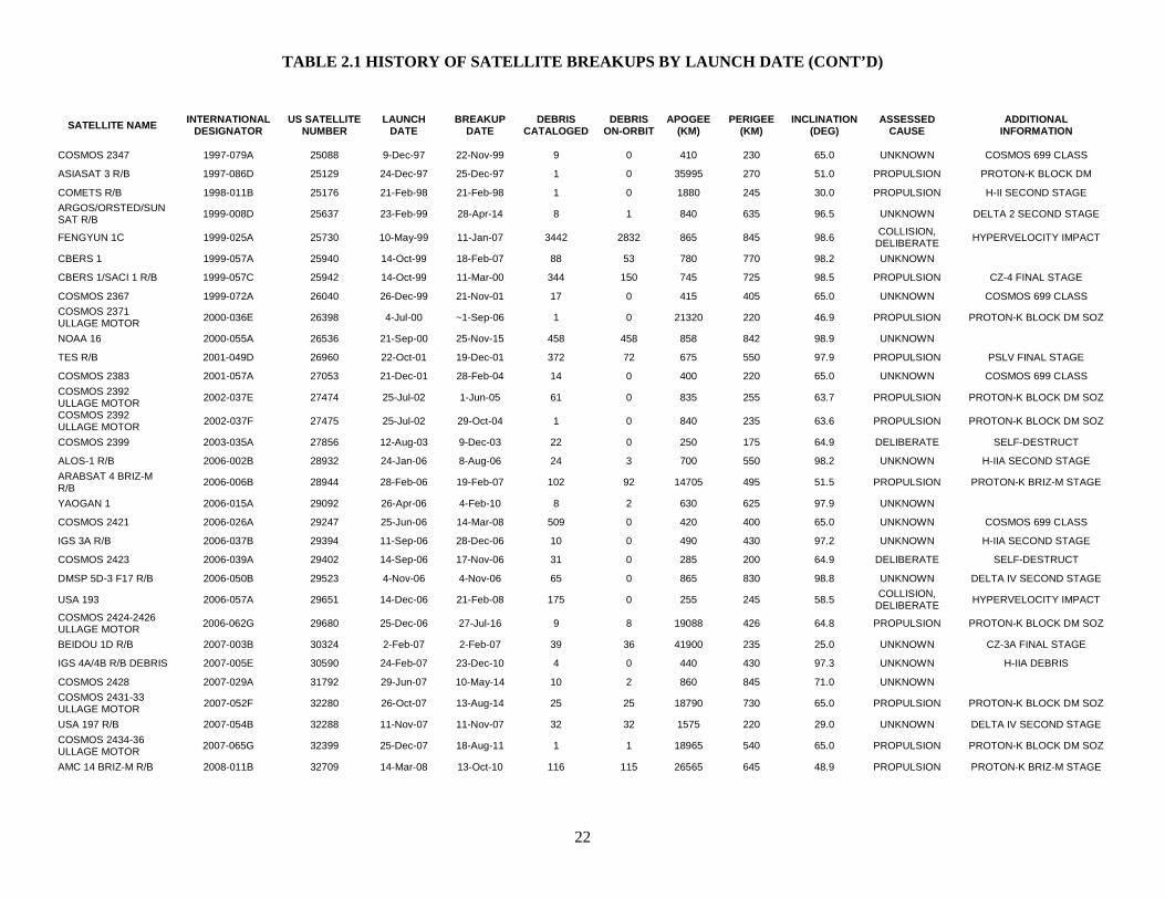
TABLE 2.1 HISTORY OF SATELLITE BREAKUPS BY LAUNCH DATE (CONT’D)
22
SATELLITE NAME INTERNATIONAL DESIGNATOR
US SATELLITE NUMBER
LAUNCH DATE
BREAKUP DATE
DEBRIS CATALOGED
DEBRIS ON-ORBIT
APOGEE (KM)
PERIGEE (KM)
INCLINATION (DEG)
ASSESSED CAUSE
ADDITIONAL INFORMATION
COSMOS 2347 1997-079A 25088 9-Dec-97 22-Nov-99 9 0 410 230 65.0 UNKNOWN COSMOS 699 CLASS
ASIASAT 3 R/B 1997-086D 25129 24-Dec-97 25-Dec-97 1 0 35995 270 51.0 PROPULSION PROTON-K BLOCK DM
COMETS R/B 1998-011B 25176 21-Feb-98 21-Feb-98 1 0 1880 245 30.0 PROPULSION H-II SECOND STAGE ARGOS/ORSTED/SUNSAT R/B 1999-008D 25637 23-Feb-99 28-Apr-14 8 1 840 635 96.5 UNKNOWN DELTA 2 SECOND STAGE
FENGYUN 1C 1999-025A 25730 10-May-99 11-Jan-07 3442 2832 865 845 98.6 COLLISION, DELIBERATE HYPERVELOCITY IMPACT
CBERS 1 1999-057A 25940 14-Oct-99 18-Feb-07 88 53 780 770 98.2 UNKNOWN
CBERS 1/SACI 1 R/B 1999-057C 25942 14-Oct-99 11-Mar-00 344 150 745 725 98.5 PROPULSION CZ-4 FINAL STAGE
COSMOS 2367 1999-072A 26040 26-Dec-99 21-Nov-01 17 0 415 405 65.0 UNKNOWN COSMOS 699 CLASS COSMOS 2371 ULLAGE MOTOR 2000-036E 26398 4-Jul-00 ~1-Sep-06 1 0 21320 220 46.9 PROPULSION PROTON-K BLOCK DM SOZ
NOAA 16 2000-055A 26536 21-Sep-00 25-Nov-15 458 458 858 842 98.9 UNKNOWN
TES R/B 2001-049D 26960 22-Oct-01 19-Dec-01 372 72 675 550 97.9 PROPULSION PSLV FINAL STAGE
COSMOS 2383 2001-057A 27053 21-Dec-01 28-Feb-04 14 0 400 220 65.0 UNKNOWN COSMOS 699 CLASS COSMOS 2392 ULLAGE MOTOR 2002-037E 27474 25-Jul-02 1-Jun-05 61 0 835 255 63.7 PROPULSION PROTON-K BLOCK DM SOZ
COSMOS 2392 ULLAGE MOTOR 2002-037F 27475 25-Jul-02 29-Oct-04 1 0 840 235 63.6 PROPULSION PROTON-K BLOCK DM SOZ
COSMOS 2399 2003-035A 27856 12-Aug-03 9-Dec-03 22 0 250 175 64.9 DELIBERATE SELF-DESTRUCT
ALOS-1 R/B 2006-002B 28932 24-Jan-06 8-Aug-06 24 3 700 550 98.2 UNKNOWN H-IIA SECOND STAGE ARABSAT 4 BRIZ-M R/B 2006-006B 28944 28-Feb-06 19-Feb-07 102 92 14705 495 51.5 PROPULSION PROTON-K BRIZ-M STAGE
YAOGAN 1 2006-015A 29092 26-Apr-06 4-Feb-10 8 2 630 625 97.9 UNKNOWN
COSMOS 2421 2006-026A 29247 25-Jun-06 14-Mar-08 509 0 420 400 65.0 UNKNOWN COSMOS 699 CLASS
IGS 3A R/B 2006-037B 29394 11-Sep-06 28-Dec-06 10 0 490 430 97.2 UNKNOWN H-IIA SECOND STAGE
COSMOS 2423 2006-039A 29402 14-Sep-06 17-Nov-06 31 0 285 200 64.9 DELIBERATE SELF-DESTRUCT
DMSP 5D-3 F17 R/B 2006-050B 29523 4-Nov-06 4-Nov-06 65 0 865 830 98.8 UNKNOWN DELTA IV SECOND STAGE
USA 193 2006-057A 29651 14-Dec-06 21-Feb-08 175 0 255 245 58.5 COLLISION, DELIBERATE HYPERVELOCITY IMPACT
COSMOS 2424-2426 ULLAGE MOTOR 2006-062G 29680 25-Dec-06 27-Jul-16 9 8 19088 426 64.8 PROPULSION PROTON-K BLOCK DM SOZ
BEIDOU 1D R/B 2007-003B 30324 2-Feb-07 2-Feb-07 39 36 41900 235 25.0 UNKNOWN CZ-3A FINAL STAGE
IGS 4A/4B R/B DEBRIS 2007-005E 30590 24-Feb-07 23-Dec-10 4 0 440 430 97.3 UNKNOWN H-IIA DEBRIS
COSMOS 2428 2007-029A 31792 29-Jun-07 10-May-14 10 2 860 845 71.0 UNKNOWN
COSMOS 2431-33 ULLAGE MOTOR 2007-052F 32280 26-Oct-07 13-Aug-14 25 25 18790 730 65.0 PROPULSION PROTON-K BLOCK DM SOZ
USA 197 R/B 2007-054B 32288 11-Nov-07 11-Nov-07 32 32 1575 220 29.0 UNKNOWN DELTA IV SECOND STAGE COSMOS 2434-36 ULLAGE MOTOR 2007-065G 32399 25-Dec-07 18-Aug-11 1 1 18965 540 65.0 PROPULSION PROTON-K BLOCK DM SOZ
AMC 14 BRIZ-M R/B 2008-011B 32709 14-Mar-08 13-Oct-10 116 115 26565 645 48.9 PROPULSION PROTON-K BRIZ-M STAGE
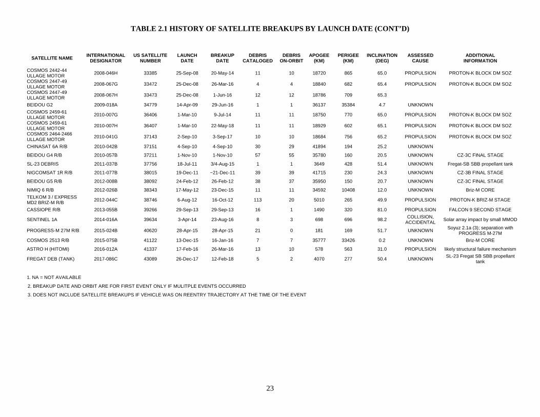
TABLE 2.1 HISTORY OF SATELLITE BREAKUPS BY LAUNCH DATE (CONT’D)
23
SATELLITE NAME INTERNATIONAL DESIGNATOR
US SATELLITE NUMBER
LAUNCH DATE
BREAKUP DATE
DEBRIS CATALOGED
DEBRIS ON-ORBIT
APOGEE (KM)
PERIGEE (KM)
INCLINATION (DEG)
ASSESSED CAUSE
ADDITIONAL INFORMATION
COSMOS 2442-44 ULLAGE MOTOR 2008-046H 33385 25-Sep-08 20-May-14 11 10 18720 865 65.0 PROPULSION PROTON-K BLOCK DM SOZ
COSMOS 2447-49 ULLAGE MOTOR 2008-067G 33472 25-Dec-08 26-Mar-16 4 4 18840 682 65.4 PROPULSION PROTON-K BLOCK DM SOZ
COSMOS 2447-49 ULLAGE MOTOR 2008-067H 33473 25-Dec-08 1-Jun-16 12 12 18786 709 65.3
BEIDOU G2 2009-018A 34779 14-Apr-09 29-Jun-16 1 1 36137 35384 4.7 UNKNOWN
COSMOS 2459-61 ULLAGE MOTOR 2010-007G 36406 1-Mar-10 9-Jul-14 11 11 18750 770 65.0 PROPULSION PROTON-K BLOCK DM SOZ
COSMOS 2459-61 ULLAGE MOTOR 2010-007H 36407 1-Mar-10 22-May-18 11 11 18929 602 65.1 PROPULSION PROTON-K BLOCK DM SOZ
COSMOS 2464-2466 ULLAGE MOTOR 2010-041G 37143 2-Sep-10 3-Sep-17 10 10 18684 756 65.2 PROPULSION PROTON-K BLOCK DM SOZ
CHINASAT 6A R/B 2010-042B 37151 4-Sep-10 4-Sep-10 30 29 41894 194 25.2 UNKNOWN
BEIDOU G4 R/B 2010-057B 37211 1-Nov-10 1-Nov-10 57 55 35780 160 20.5 UNKNOWN CZ-3C FINAL STAGE
SL-23 DEBRIS 2011-037B 37756 18-Jul-11 3/4-Aug-15 1 1 3649 428 51.4 UNKNOWN Fregat-SB SBB propellant tank
NIGCOMSAT 1R R/B 2011-077B 38015 19-Dec-11 ~21-Dec-11 39 39 41715 230 24.3 UNKNOWN CZ-3B FINAL STAGE
BEIDOU G5 R/B 2012-008B 38092 24-Feb-12 26-Feb-12 38 37 35950 150 20.7 UNKNOWN CZ-3C FINAL STAGE
NIMIQ 6 R/B 2012-026B 38343 17-May-12 23-Dec-15 11 11 34592 10408 12.0 UNKNOWN Briz-M CORE TELKOM 3 / EXPRESS MD2 BRIZ-M R/B 2012-044C 38746 6-Aug-12 16-Oct-12 113 20 5010 265 49.9 PROPULSION PROTON-K BRIZ-M STAGE
CASSIOPE R/B 2013-055B 39266 29-Sep-13 29-Sep-13 16 1 1490 320 81.0 PROPULSION FALCON 9 SECOND STAGE
SENTINEL 1A 2014-016A 39634 3-Apr-14 23-Aug-16 8 3 698 696 98.2 COLLISION, ACCIDENTAL Solar array impact by small MMOD
PROGRESS-M 27M R/B 2015-024B 40620 28-Apr-15 28-Apr-15 21 0 181 169 51.7 UNKNOWN Soyuz 2.1a (3); separation with PROGRESS M-27M
COSMOS 2513 R/B 2015-075B 41122 13-Dec-15 16-Jan-16 7 7 35777 33426 0.2 UNKNOWN Briz-M CORE
ASTRO H (HITOMI) 2016-012A 41337 17-Feb-16 26-Mar-16 13 10 578 563 31.0 PROPULSION likely structural failure mechanism
FREGAT DEB (TANK) 2017-086C 43089 26-Dec-17 12-Feb-18 5 2 4070 277 50.4 UNKNOWN SL-23 Fregat SB SBB propellant tank
1. NA = NOT AVAILABLE
2. BREAKUP DATE AND ORBIT ARE FOR FIRST EVENT ONLY IF MULITPLE EVENTS OCCURRED
3. DOES NOT INCLUDE SATELLITE BREAKUPS IF VEHICLE WAS ON REENTRY TRAJECTORY AT THE TIME OF THE EVENT
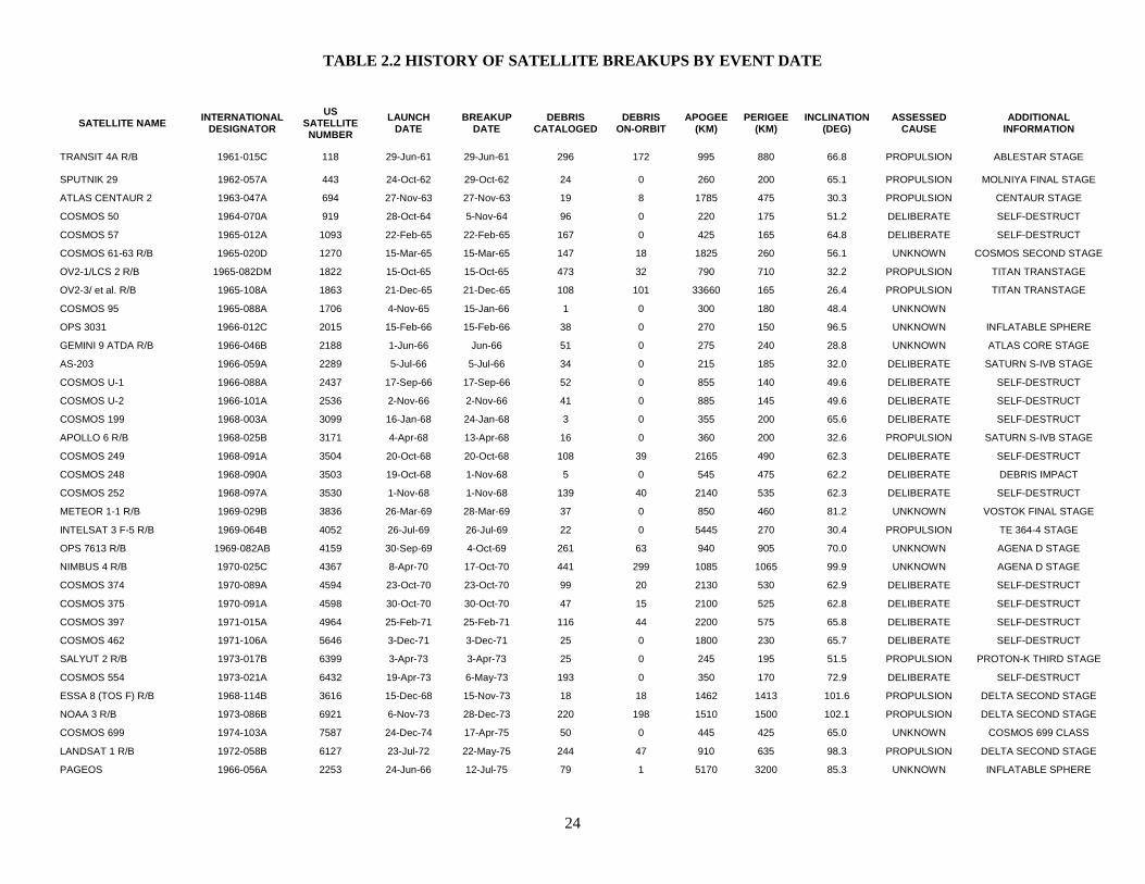
TABLE 2.2 HISTORY OF SATELLITE BREAKUPS BY EVENT DATE
24
SATELLITE NAME INTERNATIONAL DESIGNATOR
US SATELLITE NUMBER
LAUNCH DATE
BREAKUP DATE
DEBRIS CATALOGED
DEBRIS ON-ORBIT
APOGEE (KM)
PERIGEE (KM)
INCLINATION (DEG)
ASSESSED CAUSE
ADDITIONAL INFORMATION
TRANSIT 4A R/B 1961-015C 118 29-Jun-61 29-Jun-61 296 172 995 880 66.8 PROPULSION ABLESTAR STAGE
SPUTNIK 29 1962-057A 443 24-Oct-62 29-Oct-62 24 0 260 200 65.1 PROPULSION MOLNIYA FINAL STAGE
ATLAS CENTAUR 2 1963-047A 694 27-Nov-63 27-Nov-63 19 8 1785 475 30.3 PROPULSION CENTAUR STAGE
COSMOS 50 1964-070A 919 28-Oct-64 5-Nov-64 96 0 220 175 51.2 DELIBERATE SELF-DESTRUCT
COSMOS 57 1965-012A 1093 22-Feb-65 22-Feb-65 167 0 425 165 64.8 DELIBERATE SELF-DESTRUCT
COSMOS 61-63 R/B 1965-020D 1270 15-Mar-65 15-Mar-65 147 18 1825 260 56.1 UNKNOWN COSMOS SECOND STAGE
OV2-1/LCS 2 R/B 1965-082DM 1822 15-Oct-65 15-Oct-65 473 32 790 710 32.2 PROPULSION TITAN TRANSTAGE
OV2-3/ et al. R/B 1965-108A 1863 21-Dec-65 21-Dec-65 108 101 33660 165 26.4 PROPULSION TITAN TRANSTAGE
COSMOS 95 1965-088A 1706 4-Nov-65 15-Jan-66 1 0 300 180 48.4 UNKNOWN
OPS 3031 1966-012C 2015 15-Feb-66 15-Feb-66 38 0 270 150 96.5 UNKNOWN INFLATABLE SPHERE
GEMINI 9 ATDA R/B 1966-046B 2188 1-Jun-66 Jun-66 51 0 275 240 28.8 UNKNOWN ATLAS CORE STAGE
AS-203 1966-059A 2289 5-Jul-66 5-Jul-66 34 0 215 185 32.0 DELIBERATE SATURN S-IVB STAGE
COSMOS U-1 1966-088A 2437 17-Sep-66 17-Sep-66 52 0 855 140 49.6 DELIBERATE SELF-DESTRUCT
COSMOS U-2 1966-101A 2536 2-Nov-66 2-Nov-66 41 0 885 145 49.6 DELIBERATE SELF-DESTRUCT
COSMOS 199 1968-003A 3099 16-Jan-68 24-Jan-68 3 0 355 200 65.6 DELIBERATE SELF-DESTRUCT
APOLLO 6 R/B 1968-025B 3171 4-Apr-68 13-Apr-68 16 0 360 200 32.6 PROPULSION SATURN S-IVB STAGE
COSMOS 249 1968-091A 3504 20-Oct-68 20-Oct-68 108 39 2165 490 62.3 DELIBERATE SELF-DESTRUCT
COSMOS 248 1968-090A 3503 19-Oct-68 1-Nov-68 5 0 545 475 62.2 DELIBERATE DEBRIS IMPACT
COSMOS 252 1968-097A 3530 1-Nov-68 1-Nov-68 139 40 2140 535 62.3 DELIBERATE SELF-DESTRUCT
METEOR 1-1 R/B 1969-029B 3836 26-Mar-69 28-Mar-69 37 0 850 460 81.2 UNKNOWN VOSTOK FINAL STAGE
INTELSAT 3 F-5 R/B 1969-064B 4052 26-Jul-69 26-Jul-69 22 0 5445 270 30.4 PROPULSION TE 364-4 STAGE
OPS 7613 R/B 1969-082AB 4159 30-Sep-69 4-Oct-69 261 63 940 905 70.0 UNKNOWN AGENA D STAGE
NIMBUS 4 R/B 1970-025C 4367 8-Apr-70 17-Oct-70 441 299 1085 1065 99.9 UNKNOWN AGENA D STAGE
COSMOS 374 1970-089A 4594 23-Oct-70 23-Oct-70 99 20 2130 530 62.9 DELIBERATE SELF-DESTRUCT
COSMOS 375 1970-091A 4598 30-Oct-70 30-Oct-70 47 15 2100 525 62.8 DELIBERATE SELF-DESTRUCT
COSMOS 397 1971-015A 4964 25-Feb-71 25-Feb-71 116 44 2200 575 65.8 DELIBERATE SELF-DESTRUCT
COSMOS 462 1971-106A 5646 3-Dec-71 3-Dec-71 25 0 1800 230 65.7 DELIBERATE SELF-DESTRUCT
SALYUT 2 R/B 1973-017B 6399 3-Apr-73 3-Apr-73 25 0 245 195 51.5 PROPULSION PROTON-K THIRD STAGE
COSMOS 554 1973-021A 6432 19-Apr-73 6-May-73 193 0 350 170 72.9 DELIBERATE SELF-DESTRUCT
ESSA 8 (TOS F) R/B 1968-114B 3616 15-Dec-68 15-Nov-73 18 18 1462 1413 101.6 PROPULSION DELTA SECOND STAGE
NOAA 3 R/B 1973-086B 6921 6-Nov-73 28-Dec-73 220 198 1510 1500 102.1 PROPULSION DELTA SECOND STAGE
COSMOS 699 1974-103A 7587 24-Dec-74 17-Apr-75 50 0 445 425 65.0 UNKNOWN COSMOS 699 CLASS
LANDSAT 1 R/B 1972-058B 6127 23-Jul-72 22-May-75 244 47 910 635 98.3 PROPULSION DELTA SECOND STAGE
PAGEOS 1966-056A 2253 24-Jun-66 12-Jul-75 79 1 5170 3200 85.3 UNKNOWN INFLATABLE SPHERE
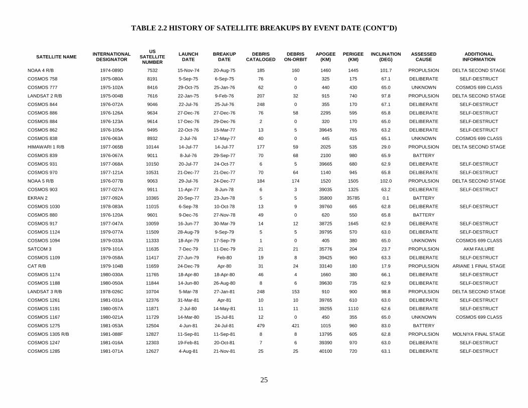
TABLE 2.2 HISTORY OF SATELLITE BREAKUPS BY EVENT DATE (CONT’D)
25
SATELLITE NAME INTERNATIONAL DESIGNATOR
US SATELLITE NUMBER
LAUNCH DATE
BREAKUP DATE
DEBRIS CATALOGED
DEBRIS ON-ORBIT
APOGEE (KM)
PERIGEE (KM)
INCLINATION (DEG)
ASSESSED CAUSE
ADDITIONAL INFORMATION
NOAA 4 R/B 1974-089D 7532 15-Nov-74 20-Aug-75 185 160 1460 1445 101.7 PROPULSION DELTA SECOND STAGE
COSMOS 758 1975-080A 8191 5-Sep-75 6-Sep-75 76 0 325 175 67.1 DELIBERATE SELF-DESTRUCT
COSMOS 777 1975-102A 8416 29-Oct-75 25-Jan-76 62 0 440 430 65.0 UNKNOWN COSMOS 699 CLASS
LANDSAT 2 R/B 1975-004B 7616 22-Jan-75 9-Feb-76 207 32 915 740 97.8 PROPULSION DELTA SECOND STAGE
COSMOS 844 1976-072A 9046 22-Jul-76 25-Jul-76 248 0 355 170 67.1 DELIBERATE SELF-DESTRUCT
COSMOS 886 1976-126A 9634 27-Dec-76 27-Dec-76 76 58 2295 595 65.8 DELIBERATE SELF-DESTRUCT
COSMOS 884 1976-123A 9614 17-Dec-76 29-Dec-76 2 0 320 170 65.0 DELIBERATE SELF-DESTRUCT
COSMOS 862 1976-105A 9495 22-Oct-76 15-Mar-77 13 5 39645 765 63.2 DELIBERATE SELF-DESTRUCT
COSMOS 838 1976-063A 8932 2-Jul-76 17-May-77 40 0 445 415 65.1 UNKNOWN COSMOS 699 CLASS
HIMAWARI 1 R/B 1977-065B 10144 14-Jul-77 14-Jul-77 177 59 2025 535 29.0 PROPULSION DELTA SECOND STAGE
COSMOS 839 1976-067A 9011 8-Jul-76 29-Sep-77 70 68 2100 980 65.9 BATTERY
COSMOS 931 1977-068A 10150 20-Jul-77 24-Oct-77 6 5 39665 680 62.9 DELIBERATE SELF-DESTRUCT
COSMOS 970 1977-121A 10531 21-Dec-77 21-Dec-77 70 64 1140 945 65.8 DELIBERATE SELF-DESTRUCT
NOAA 5 R/B 1976-077B 9063 29-Jul-76 24-Dec-77 184 174 1520 1505 102.0 PROPULSION DELTA SECOND STAGE
COSMOS 903 1977-027A 9911 11-Apr-77 8-Jun-78 6 3 39035 1325 63.2 DELIBERATE SELF-DESTRUCT
EKRAN 2 1977-092A 10365 20-Sep-77 23-Jun-78 5 5 35800 35785 0.1 BATTERY
COSMOS 1030 1978-083A 11015 6-Sep-78 10-Oct-78 13 9 39760 665 62.8 DELIBERATE SELF-DESTRUCT
COSMOS 880 1976-120A 9601 9-Dec-76 27-Nov-78 49 0 620 550 65.8 BATTERY
COSMOS 917 1977-047A 10059 16-Jun-77 30-Mar-79 14 12 38725 1645 62.9 DELIBERATE SELF-DESTRUCT
COSMOS 1124 1979-077A 11509 28-Aug-79 9-Sep-79 5 5 39795 570 63.0 DELIBERATE SELF-DESTRUCT
COSMOS 1094 1979-033A 11333 18-Apr-79 17-Sep-79 1 0 405 380 65.0 UNKNOWN COSMOS 699 CLASS
SATCOM 3 1979-101A 11635 7-Dec-79 11-Dec-79 21 21 35776 204 23.7 PROPULSION AKM FAILURE
COSMOS 1109 1979-058A 11417 27-Jun-79 Feb-80 19 8 39425 960 63.3 DELIBERATE SELF-DESTRUCT
CAT R/B 1979-104B 11659 24-Dec-79 Apr-80 31 24 33140 180 17.9 PROPULSION ARIANE 1 FINAL STAGE
COSMOS 1174 1980-030A 11765 18-Apr-80 18-Apr-80 46 4 1660 380 66.1 DELIBERATE SELF-DESTRUCT
COSMOS 1188 1980-050A 11844 14-Jun-80 26-Aug-80 8 6 39630 735 62.9 DELIBERATE SELF-DESTRUCT
LANDSAT 3 R/B 1978-026C 10704 5-Mar-78 27-Jan-81 248 153 910 900 98.8 PROPULSION DELTA SECOND STAGE
COSMOS 1261 1981-031A 12376 31-Mar-81 Apr-81 10 10 39765 610 63.0 DELIBERATE SELF-DESTRUCT
COSMOS 1191 1980-057A 11871 2-Jul-80 14-May-81 11 11 39255 1110 62.6 DELIBERATE SELF-DESTRUCT
COSMOS 1167 1980-021A 11729 14-Mar-80 15-Jul-81 12 0 450 355 65.0 UNKNOWN COSMOS 699 CLASS
COSMOS 1275 1981-053A 12504 4-Jun-81 24-Jul-81 479 421 1015 960 83.0 BATTERY
COSMOS 1305 R/B 1981-088F 12827 11-Sep-81 11-Sep-81 8 8 13795 605 62.8 PROPULSION MOLNIYA FINAL STAGE
COSMOS 1247 1981-016A 12303 19-Feb-81 20-Oct-81 7 6 39390 970 63.0 DELIBERATE SELF-DESTRUCT
COSMOS 1285 1981-071A 12627 4-Aug-81 21-Nov-81 25 25 40100 720 63.1 DELIBERATE SELF-DESTRUCT
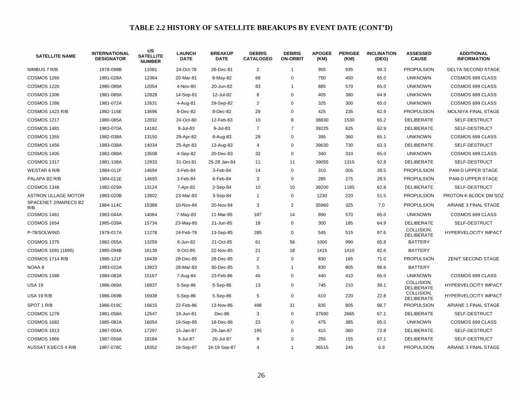
TABLE 2.2 HISTORY OF SATELLITE BREAKUPS BY EVENT DATE (CONT’D)
26
SATELLITE NAME INTERNATIONAL DESIGNATOR
US SATELLITE NUMBER
LAUNCH DATE
BREAKUP DATE
DEBRIS CATALOGED
DEBRIS ON-ORBIT
APOGEE (KM)
PERIGEE (KM)
INCLINATION (DEG)
ASSESSED CAUSE
ADDITIONAL INFORMATION
NIMBUS 7 R/B 1978-098B 11081 24-Oct-78 26-Dec-81 2 1 955 935 99.3 PROPULSION DELTA SECOND STAGE
COSMOS 1260 1981-028A 12364 20-Mar-81 8-May-82 68 0 750 450 65.0 UNKNOWN COSMOS 699 CLASS
COSMOS 1220 1980-089A 12054 4-Nov-80 20-Jun-82 83 1 885 570 65.0 UNKNOWN COSMOS 699 CLASS
COSMOS 1306 1981-089A 12828 14-Sep-81 12-Jul-82 8 0 405 380 64.9 UNKNOWN COSMOS 699 CLASS
COSMOS 1286 1981-072A 12631 4-Aug-81 29-Sep-82 2 0 325 300 65.0 UNKNOWN COSMOS 699 CLASS
COSMOS 1423 R/B 1982-115E 13696 8-Dec-82 8-Dec-82 29 0 425 235 62.9 PROPULSION MOLNIYA FINAL STAGE
COSMOS 1217 1980-085A 12032 24-Oct-80 12-Feb-83 10 8 38830 1530 65.2 DELIBERATE SELF-DESTRUCT
COSMOS 1481 1983-070A 14182 8-Jul-83 9-Jul-83 7 7 39225 625 62.9 DELIBERATE SELF-DESTRUCT
COSMOS 1355 1982-038A 13150 29-Apr-82 8-Aug-83 29 0 395 360 65.1 UNKNOWN COSMOS 699 CLASS
COSMOS 1456 1983-038A 14034 25-Apr-83 13-Aug-83 4 0 39630 730 63.3 DELIBERATE SELF-DESTRUCT
COSMOS 1405 1982-088A 13508 4-Sep-82 20-Dec-83 32 0 340 310 65.0 UNKNOWN COSMOS 699 CLASS
COSMOS 1317 1981-108A 12933 31-Oct-81 25-28 Jan-84 11 11 39055 1315 62.8 DELIBERATE SELF-DESTRUCT
WESTAR 6 R/B 1984-011F 14694 3-Feb-84 3-Feb-84 14 0 310 305 28.5 PROPULSION PAM-D UPPER STAGE
PALAPA B2 R/B 1984-011E 14693 3-Feb-84 6-Feb-84 3 0 285 275 28.5 PROPULSION PAM-D UPPER STAGE
COSMOS 1348 1982-029A 13124 7-Apr-82 2-Sep-84 10 10 39200 1185 62.8 DELIBERATE SELF-DESTRUCT
ASTRON ULLAGE MOTOR 1983-020B 13902 23-Mar-83 3-Sep-84 1 0 1230 220 51.5 PROPULSION PROTON-K BLOCK DM SOZ SPACENET 2/MARECS B2 R/B 1984-114C 15388 10-Nov-84 20-Nov-84 3 2 35960 325 7.0 PROPULSION ARIANE 3 FINAL STAGE
COSMOS 1461 1983-044A 14064 7-May-83 11-Mar-85 187 14 890 570 65.0 UNKNOWN COSMOS 699 CLASS
COSMOS 1654 1985-039A 15734 23-May-85 21-Jun-85 18 0 300 185 64.9 DELIBERATE SELF-DESTRUCT
P-78/SOLWIND 1979-017A 11278 24-Feb-79 13-Sep-85 285 0 545 515 97.6 COLLISION, DELIBERATE HYPERVELOCITY IMPACT
COSMOS 1375 1982-055A 13259 6-Jun-82 21-Oct-85 61 58 1000 990 65.8 BATTERY
COSMOS 1691 (1695) 1985-094B 16139 9-Oct-85 22-Nov-85 21 18 1415 1410 82.6 BATTERY
COSMOS 1714 R/B 1985-121F 16439 28-Dec-85 28-Dec-85 2 0 830 165 71.0 PROPULSION ZENIT SECOND STAGE
NOAA 8 1983-022A 13923 28-Mar-83 30-Dec-85 5 1 830 805 98.6 BATTERY
COSMOS 1588 1984-083A 15167 7-Aug-84 23-Feb-86 45 0 440 410 65.0 UNKNOWN COSMOS 699 CLASS
USA 19 1986-069A 16937 5-Sep-86 5-Sep-86 13 0 745 210 39.1 COLLISION, DELIBERATE HYPERVELOCITY IMPACT
USA 19 R/B 1986-069B 16938 5-Sep-86 5-Sep-86 5 0 610 220 22.8 COLLISION, DELIBERATE HYPERVELOCITY IMPACT
SPOT 1 R/B 1986-019C 16615 22-Feb-86 13-Nov-86 498 31 835 805 98.7 PROPULSION ARIANE 1 FINAL STAGE
COSMOS 1278 1981-058A 12547 19-Jun-81 Dec-86 3 0 37690 2665 67.1 DELIBERATE SELF-DESTRUCT
COSMOS 1682 1985-082A 16054 19-Sep-85 18-Dec-86 23 0 475 385 65.0 UNKNOWN COSMOS 699 CLASS
COSMOS 1813 1987-004A 17297 15-Jan-87 29-Jan-87 195 0 415 360 72.8 DELIBERATE SELF-DESTRUCT
COSMOS 1866 1987-059A 18184 9-Jul-87 26-Jul-87 9 0 255 155 67.1 DELIBERATE SELF-DESTRUCT
AUSSAT K3/ECS 4 R/B 1987-078C 18352 16-Sep-87 16-19 Sep-87 4 1 36515 245 6.9 PROPULSION ARIANE 3 FINAL STAGE
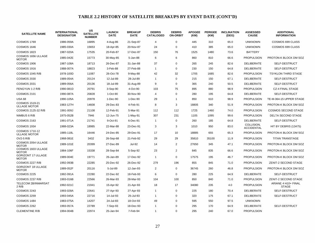
TABLE 2.2 HISTORY OF SATELLITE BREAKUPS BY EVENT DATE (CONT’D)
27
SATELLITE NAME INTERNATIONAL DESIGNATOR
US SATELLITE NUMBER
LAUNCH DATE
BREAKUP DATE
DEBRIS CATALOGED
DEBRIS ON-ORBIT
APOGEE (KM)
PERIGEE (KM)
INCLINATION (DEG)
ASSESSED CAUSE
ADDITIONAL INFORMATION
COSMOS 1769 1986-059A 16895 4-Aug-86 21-Sep-87 4 0 445 310 65.0 UNKNOWN COSMOS 699 CLASS
COSMOS 1646 1985-030A 15653 18-Apr-85 20-Nov-87 24 0 410 385 65.0 UNKNOWN COSMOS 699 CLASS
COSMOS 1823 1987-020A 17535 20-Feb-87 17-Dec-87 150 76 1525 1480 73.6 BATTERY
COSMOS 1656 ULLAGE MOTOR 1985-042E 15773 30-May-85 5-Jan-88 6 6 860 810 66.6 PROPULSION PROTON-K BLOCK DM SOZ
COSMOS 1906 1987-108A 18713 26-Dec-87 31-Jan-88 37 0 265 245 82.6 DELIBERATE SELF-DESTRUCT
COSMOS 1916 1988-007A 18823 3-Feb-88 27-Feb-88 1 0 230 150 64.8 DELIBERATE SELF-DESTRUCT
COSMOS 1045 R/B 1978-100D 11087 26-Oct-78 9-May-88 42 32 1705 1685 82.6 PROPULSION TSYKLON THIRD STAGE
COSMOS 2030 1989-054A 20124 12-Jul-89 28-Jul-89 1 0 215 150 67.1 DELIBERATE SELF-DESTRUCT
COSMOS 2031 1989-056A 20136 18-Jul-89 31-Aug-89 9 0 365 240 50.5 DELIBERATE SELF-DESTRUCT
FENGYUN 1-2 R/B 1990-081D 20791 3-Sep-90 4-Oct-90 103 75 895 880 98.9 PROPULSION CZ-4 FINAL STAGE
COSMOS 2101 1990-087A 20828 1-Oct-90 30-Nov-90 4 0 280 195 64.8 DELIBERATE SELF-DESTRUCT
USA 68 1990-105A 20978 1-Dec-90 1-Dec-90 29 1 850 610 98.9 PROPULSION TE-M-364-15 UPPER STAGE COSMOS 1519-21 ULLAGE MOTOR 1983-127H 14608 29-Dec-83 4-Feb-91 8 3 18805 340 51.9 PROPULSION PROTON-K BLOCK DM SOZ
COSMOS 2125-32 R/B 1991-009J 21108 12-Feb-91 5-Mar-91 112 112 1725 1460 74.0 PROPULSION COSMOS SECOND STAGE
NIMBUS 6 R/B 1975-052B 7946 12-Jun-75 1-May-91 307 231 1105 1095 99.6 PROPULSION DELTA SECOND STAGE
COSMOS 2163 1991-071A 21741 9-Oct-91 6-Dec-91 1 0 260 185 64.8 DELIBERATE SELF-DESTRUCT
COSMOS 1934 1988-023A 18985 22-Mar-88 23-Dec-91 3 3 1010 950 83.0 COLLISION, ACCIDENTAL HIT BY DEBRIS (13475)
COSMOS 1710-12 ULLAGE MOTOR 1985-118L 16446 24-Dec-85 29-Dec-91 17 10 18885 655 65.3 PROPULSION PROTON-K BLOCK DM SOZ
OV2-5 R/B 1968-081E 3432 26-Sep-68 21-Feb-92 29 29 35810 35100 11.9 PROPULSION TITAN TRANSTAGE COSMOS 2054 ULLAGE MOTOR 1989-101E 20399 27-Dec-89 Jul-92 14 2 27650 345 47.1 PROPULSION PROTON-K BLOCK DM SOZ
COSMOS 1603 ULLAGE MOTOR 1984-106F 15338 28-Sep-84 5-Sep-92 23 2 845 835 66.6 PROPULSION PROTON-K BLOCK DM SOZ
GORIZONT 17 ULLAGE MOTOR 1989-004E 19771 26-Jan-89 17-Dec-92 1 0 17575 195 46.7 PROPULSION PROTON-K BLOCK DM SOZ
COSMOS 2227 R/B 1992-093B 22285 25-Dec-92 26-Dec-92 279 196 855 845 71.0 PROPULSION ZENIT-2 SECOND STAGE GORIZONT 18 ULLAGE MOTOR 1989-052F 20116 5-Jul-89 12-Jan-93 2 0 36745 260 46.8 PROPULSION PROTON-K BLOCK DM SOZ
COSMOS 2225 1992-091A 22280 22-Dec-92 18-Feb-93 6 0 280 225 64.9 DELIBERATE SELF-DESTRUCT
COSMOS 2237 R/B 1993-016B 22566 26-Mar-93 28-Mar-93 104 100 850 840 71.0 PROPULSION ZENIT-2 SECOND STAGE TELECOM 2B/INMARSAT 2 R/B 1992-021C 21941 15-Apr-92 21-Apr-93 18 17 34080 235 4.0 PROPULSION ARIANE 4 H10+ FINAL
STAGE COSMOS 2243 1993-028A 22641 27-Apr-93 27-Apr-93 1 0 225 180 70.4 DELIBERATE SELF-DESTRUCT
COSMOS 2259 1993-045A 22716 14-Jul-93 25-Jul-93 1 0 320 175 67.1 DELIBERATE SELF-DESTRUCT
COSMOS 1484 1983-075A 14207 24-Jul-83 18-Oct-93 49 0 595 550 97.5 UNKNOWN
COSMOS 2262 1993-057A 22789 7-Sep-93 18-Dec-93 1 0 295 170 64.9 DELIBERATE SELF-DESTRUCT
CLEMENTINE R/B 1994-004B 22974 25-Jan-94 7-Feb-94 1 0 295 240 67.0 PROPULSION

TABLE 2.2 HISTORY OF SATELLITE BREAKUPS BY EVENT DATE (CONT’D)
28
SATELLITE NAME INTERNATIONAL DESIGNATOR
US SATELLITE NUMBER
LAUNCH DATE
BREAKUP DATE
DEBRIS CATALOGED
DEBRIS ON-ORBIT
APOGEE (KM)
PERIGEE (KM)
INCLINATION (DEG)
ASSESSED CAUSE
ADDITIONAL INFORMATION
ASTRA 1B/MOP 2 R/B 1991-015C 21141 2-Mar-91 27-Apr-94 11 7 17630 205 6.8 PROPULSION ARIANE 4 H10 FINAL STAGE COSMOS 2133 ULLAGE MOTOR 1991-010D 21114 12-Feb-91 7-May-94 4 0 21805 225 46.6 PROPULSION PROTON-K BLOCK DM SOZ
COSMOS 2204-06 ULLAGE MOTOR 1992-047H 22067 30-Jul-92 8-Nov-94 4 2 19035 480 64.8 PROPULSION PROTON-K BLOCK DM SOZ
COSMOS 2238 1993-018A 22585 30-Mar-93 1-Dec-94 1 0 305 210 65.0 UNKNOWN COSMOS 699 CLASS
RS-15 R/B 1994-085B 23440 26-Dec-94 26-Dec-94 26 23 2200 1880 64.8 UNKNOWN ROKOT THIRD STAGE ELEKTRO ULLAGE MOTOR 1994-069E 23338 31-Oct-94 11-May-95 1 0 35465 155 46.9 PROPULSION PROTON-K BLOCK DM SOZ
COSMOS 2282 ULLAGE MOTOR 1994-038F 23174 6-Jul-94 21-Oct-95 2 0 34930 280 47.0 PROPULSION PROTON-K BLOCK DM SOZ
GORIZONT 22 ULLAGE MOTOR 1990-102E 20957 23-Nov-90 14-Dec-95 2 1 13105 170 46.5 PROPULSION PROTON-K BLOCK DM SOZ
RADUGA 33 R/B 1996-010D 23797 19-Feb-96 19-Feb-96 1 0 36505 240 48.7 PROPULSION PROTON-K BLOCK DM ITALSAT 1/EUTELSAT 2 F2 R/B 1991-003C 21057 15-Jan-91 Apr/May 96 15 12 30930 235 6.7 PROPULSION ARIANE 4 H10 FINAL STAGE
STEP II R/B 1994-029B 23106 19-May-94 3-Jun-96 754 82 820 585 82.0 PROPULSION PEGASUS HAPS
CERISE 1995-033B 23606 7-Jul-95 24-Jul-96 2 1 675 665 98.1 COLLISION, ACCIDENTAL HIT BY DEBRIS (18208)
COSMOS 1883-85 ULLAGE MOTOR 1987-079G 18374 16-Sep-87 1-Dec-96 14 11 19120 335 64.9 PROPULSION PROTON-K BLOCK DM SOZ
EKRAN 17 ULLAGE MOTOR 1987-109E 18719 27-Dec-87 22-May-97 1 0 22975 310 46.6 PROPULSION PROTON-K BLOCK DM SOZ
COSMOS 2313 1995-028A 23596 8-Jun-95 26-Jun-97 13 0 325 210 65.0 UNKNOWN COSMOS 699 CLASS
COSMOS 2343 1997-024A 24805 15-May-97 16-Sep-97 1 0 285 225 65.0 DELIBERATE SELF-DESTRUCT
COSMOS 1869 1987-062A 18214 16-Jul-87 27-Nov-97 2 1 635 605 83.0 UNKNOWN
ASIASAT 3 R/B 1997-086D 25129 24-Dec-97 25-Dec-97 1 0 35995 270 51.0 PROPULSION PROTON-K BLOCK DM
METEOR 2-16 R/B 1987-068B 18313 18-Aug-87 15-Feb-98 108 42 960 940 82.6 PROPULSION TSYKLON THIRD STAGE SKYNET 4B/ASTRA 1A R/B 1988-109C 19689 11-Dec-88 17-Feb-98 18 17 35875 435 7.3 PROPULSION ARIANE 4 H10 FINAL STAGE
COMETS R/B 1998-011B 25176 21-Feb-98 21-Feb-98 1 0 1880 245 30.0 PROPULSION H-II SECOND STAGE COSMOS 2109-11 ULLAGE MOTOR 1990-110H 21013 8-Dec-90 14-Mar-98 2 2 18995 520 65.1 PROPULSION PROTON-K BLOCK DM SOZ
COSMOS 1987-89 ULLAGE MOTOR 1989-001G 19755 10-Jan-89 3-Aug-98 16 6 19055 340 64.9 PROPULSION PROTON-K BLOCK DM SOZ
COSMOS 1650-52 ULLAGE MOTOR 1985-037G 15714 17-May-85 29-Nov-98 4 2 18620 320 52.0 PROPULSION PROTON-K BLOCK DM SOZ
COSMOS 1970-72 ULLAGE MOTOR 1988-085G 19537 16-Sep-88 9-Mar-99 1 1 18950 300 64.6 PROPULSION PROTON-K BLOCK DM SOZ
COSMOS 2079-81 ULLAGE MOTOR 1990-045G 20631 19-May-90 28-Mar-99 1 1 19065 405 64.8 PROPULSION PROTON-K BLOCK DM SOZ
COSMOS 2053 R/B 1989-100B 20390 27-Dec-89 18-Apr-99 26 0 485 475 73.5 PROPULSION TSYKLON THIRD STAGE
METEOR 2-8 1982-025A 13113 25-Mar-82 29-May-99 53 53 960 935 82.5 UNKNOWN
COSMOS 2157-62 R/B 1991-068G 21734 28-Sep-91 9-Oct-99 40 40 1485 1410 82.6 PROPULSION TSYKLON THIRD STAGE
COSMOS 2347 1997-079A 25088 9-Dec-97 22-Nov-99 9 0 410 230 65.0 UNKNOWN COSMOS 699 CLASS
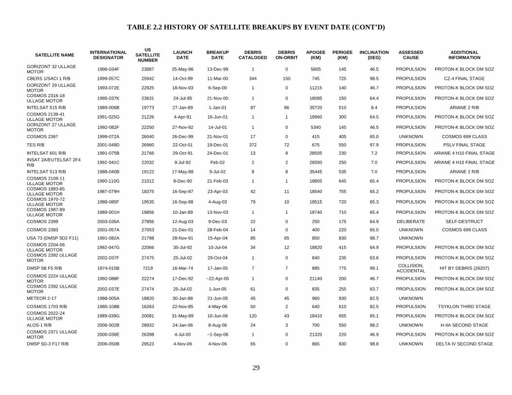
TABLE 2.2 HISTORY OF SATELLITE BREAKUPS BY EVENT DATE (CONT’D)
29
SATELLITE NAME INTERNATIONAL DESIGNATOR
US SATELLITE NUMBER
LAUNCH DATE
BREAKUP DATE
DEBRIS CATALOGED
DEBRIS ON-ORBIT
APOGEE (KM)
PERIGEE (KM)
INCLINATION (DEG)
ASSESSED CAUSE
ADDITIONAL INFORMATION
GORIZONT 32 ULLAGE MOTOR 1996-034F 23887 25-May-96 13-Dec-99 1 0 5605 145 46.5 PROPULSION PROTON-K BLOCK DM SOZ
CBERS 1/SACI 1 R/B 1999-057C 25942 14-Oct-99 11-Mar-00 344 150 745 725 98.5 PROPULSION CZ-4 FINAL STAGE GORIZONT 29 ULLAGE MOTOR 1993-072E 22925 18-Nov-93 6-Sep-00 1 0 11215 140 46.7 PROPULSION PROTON-K BLOCK DM SOZ
COSMOS 2316-18 ULLAGE MOTOR 1995-037K 23631 24-Jul-95 21-Nov-00 1 0 18085 150 64.4 PROPULSION PROTON-K BLOCK DM SOZ
INTELSAT 515 R/B 1989-006B 19773 27-Jan-89 1-Jan-01 87 86 35720 510 8.4 PROPULSION ARIANE 2 R/B COSMOS 2139-41 ULLAGE MOTOR 1991-025G 21226 4-Apr-91 16-Jun-01 1 1 18960 300 64.5 PROPULSION PROTON-K BLOCK DM SOZ
GORIZONT 27 ULLAGE MOTOR 1992-082F 22250 27-Nov-92 14-Jul-01 1 0 5340 145 46.5 PROPULSION PROTON-K BLOCK DM SOZ
COSMOS 2367 1999-072A 26040 26-Dec-99 21-Nov-01 17 0 415 405 65.0 UNKNOWN COSMOS 699 CLASS
TES R/B 2001-049D 26960 22-Oct-01 19-Dec-01 372 72 675 550 97.9 PROPULSION PSLV FINAL STAGE
INTELSAT 601 R/B 1991-075B 21766 29-Oct-91 24-Dec-01 13 8 28505 230 7.2 PROPULSION ARIANE 4 H10 FINAL STAGE INSAT 2A/EUTELSAT 2F4 R/B 1992-041C 22032 9-Jul-92 Feb-02 2 2 26550 250 7.0 PROPULSION ARIANE 4 H10 FINAL STAGE
INTELSAT 513 R/B 1988-040B 19122 17-May-88 9-Jul-02 8 8 35445 535 7.0 PROPULSION ARIANE 2 R/B COSMOS 2109-11 ULLAGE MOTOR 1990-110G 21012 8-Dec-90 21-Feb-03 1 1 18805 645 65.4 PROPULSION PROTON-K BLOCK DM SOZ
COSMOS 1883-85 ULLAGE MOTOR 1987-079H 18375 16-Sep-87 23-Apr-03 42 11 18540 755 65.2 PROPULSION PROTON-K BLOCK DM SOZ
COSMOS 1970-72 ULLAGE MOTOR 1988-085F 19535 16-Sep-88 4-Aug-03 79 10 18515 720 65.3 PROPULSION PROTON-K BLOCK DM SOZ
COSMOS 1987-89 ULLAGE MOTOR 1989-001H 19856 10-Jan-89 13-Nov-03 1 1 18740 710 65.4 PROPULSION PROTON-K BLOCK DM SOZ
COSMOS 2399 2003-035A 27856 12-Aug-03 9-Dec-03 22 0 250 175 64.9 DELIBERATE SELF-DESTRUCT
COSMOS 2383 2001-057A 27053 21-Dec-01 28-Feb-04 14 0 400 220 65.0 UNKNOWN COSMOS 699 CLASS
USA 73 (DMSP 5D2 F11) 1991-082A 21798 28-Nov-91 15-Apr-04 85 65 850 830 98.7 UNKNOWN
COSMOS 2204-06 ULLAGE MOTOR 1992-047G 22066 30-Jul-92 10-Jul-04 34 12 18820 415 64.9 PROPULSION PROTON-K BLOCK DM SOZ
COSMOS 2392 ULLAGE MOTOR 2002-037F 27475 25-Jul-02 29-Oct-04 1 0 840 235 63.6 PROPULSION PROTON-K BLOCK DM SOZ
DMSP 5B F5 R/B 1974-015B 7219 16-Mar-74 17-Jan-05 7 7 885 775 99.1 COLLISION, ACCIDENTAL HIT BY DEBRIS (26207)
COSMOS 2224 ULLAGE MOTOR 1992-088F 22274 17-Dec-92 ~22-Apr-05 1 0 21140 200 46.7 PROPULSION PROTON-K BLOCK DM SOZ
COSMOS 2392 ULLAGE MOTOR 2002-037E 27474 25-Jul-02 1-Jun-05 61 0 835 255 63.7 PROPULSION PROTON-K BLOCK DM SOZ
METEOR 2-17 1988-005A 18820 30-Jan-88 21-Jun-05 45 45 960 930 82.5 UNKNOWN
COSMOS 1703 R/B 1985-108B 16263 22-Nov-85 4-May-06 50 2 640 610 82.5 PROPULSION TSYKLON THIRD STAGE COSMOS 2022-24 ULLAGE MOTOR 1989-039G 20081 31-May-89 10-Jun-06 120 43 18410 655 65.1 PROPULSION PROTON-K BLOCK DM SOZ
ALOS-1 R/B 2006-002B 28932 24-Jan-06 8-Aug-06 24 3 700 550 98.2 UNKNOWN H-IIA SECOND STAGE COSMOS 2371 ULLAGE MOTOR 2000-036E 26398 4-Jul-00 ~1-Sep-06 1 0 21320 220 46.9 PROPULSION PROTON-K BLOCK DM SOZ
DMSP 5D-3 F17 R/B 2006-050B 29523 4-Nov-06 4-Nov-06 65 0 865 830 98.8 UNKNOWN DELTA IV SECOND STAGE
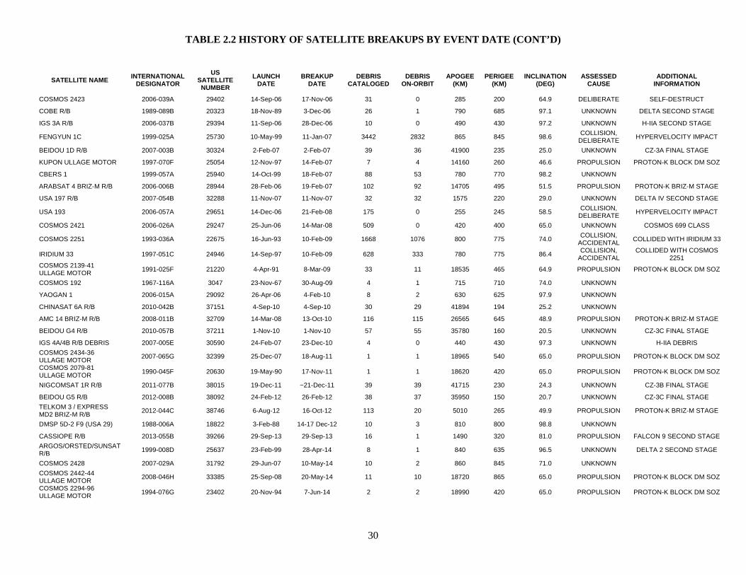
TABLE 2.2 HISTORY OF SATELLITE BREAKUPS BY EVENT DATE (CONT’D)
30
SATELLITE NAME INTERNATIONAL DESIGNATOR
US SATELLITE NUMBER
LAUNCH DATE
BREAKUP DATE
DEBRIS CATALOGED
DEBRIS ON-ORBIT
APOGEE (KM)
PERIGEE (KM)
INCLINATION (DEG)
ASSESSED CAUSE
ADDITIONAL INFORMATION
COSMOS 2423 2006-039A 29402 14-Sep-06 17-Nov-06 31 0 285 200 64.9 DELIBERATE SELF-DESTRUCT
COBE R/B 1989-089B 20323 18-Nov-89 3-Dec-06 26 1 790 685 97.1 UNKNOWN DELTA SECOND STAGE
IGS 3A R/B 2006-037B 29394 11-Sep-06 28-Dec-06 10 0 490 430 97.2 UNKNOWN H-IIA SECOND STAGE
FENGYUN 1C 1999-025A 25730 10-May-99 11-Jan-07 3442 2832 865 845 98.6 COLLISION, DELIBERATE HYPERVELOCITY IMPACT
BEIDOU 1D R/B 2007-003B 30324 2-Feb-07 2-Feb-07 39 36 41900 235 25.0 UNKNOWN CZ-3A FINAL STAGE
KUPON ULLAGE MOTOR 1997-070F 25054 12-Nov-97 14-Feb-07 7 4 14160 260 46.6 PROPULSION PROTON-K BLOCK DM SOZ
CBERS 1 1999-057A 25940 14-Oct-99 18-Feb-07 88 53 780 770 98.2 UNKNOWN
ARABSAT 4 BRIZ-M R/B 2006-006B 28944 28-Feb-06 19-Feb-07 102 92 14705 495 51.5 PROPULSION PROTON-K BRIZ-M STAGE
USA 197 R/B 2007-054B 32288 11-Nov-07 11-Nov-07 32 32 1575 220 29.0 UNKNOWN DELTA IV SECOND STAGE
USA 193 2006-057A 29651 14-Dec-06 21-Feb-08 175 0 255 245 58.5 COLLISION, DELIBERATE HYPERVELOCITY IMPACT
COSMOS 2421 2006-026A 29247 25-Jun-06 14-Mar-08 509 0 420 400 65.0 UNKNOWN COSMOS 699 CLASS
COSMOS 2251 1993-036A 22675 16-Jun-93 10-Feb-09 1668 1076 800 775 74.0 COLLISION, ACCIDENTAL COLLIDED WITH IRIDIUM 33
IRIDIUM 33 1997-051C 24946 14-Sep-97 10-Feb-09 628 333 780 775 86.4 COLLISION, ACCIDENTAL
COLLIDED WITH COSMOS 2251
COSMOS 2139-41 ULLAGE MOTOR 1991-025F 21220 4-Apr-91 8-Mar-09 33 11 18535 465 64.9 PROPULSION PROTON-K BLOCK DM SOZ
COSMOS 192 1967-116A 3047 23-Nov-67 30-Aug-09 4 1 715 710 74.0 UNKNOWN
YAOGAN 1 2006-015A 29092 26-Apr-06 4-Feb-10 8 2 630 625 97.9 UNKNOWN
CHINASAT 6A R/B 2010-042B 37151 4-Sep-10 4-Sep-10 30 29 41894 194 25.2 UNKNOWN
AMC 14 BRIZ-M R/B 2008-011B 32709 14-Mar-08 13-Oct-10 116 115 26565 645 48.9 PROPULSION PROTON-K BRIZ-M STAGE
BEIDOU G4 R/B 2010-057B 37211 1-Nov-10 1-Nov-10 57 55 35780 160 20.5 UNKNOWN CZ-3C FINAL STAGE
IGS 4A/4B R/B DEBRIS 2007-005E 30590 24-Feb-07 23-Dec-10 4 0 440 430 97.3 UNKNOWN H-IIA DEBRIS COSMOS 2434-36 ULLAGE MOTOR 2007-065G 32399 25-Dec-07 18-Aug-11 1 1 18965 540 65.0 PROPULSION PROTON-K BLOCK DM SOZ
COSMOS 2079-81 ULLAGE MOTOR 1990-045F 20630 19-May-90 17-Nov-11 1 1 18620 420 65.0 PROPULSION PROTON-K BLOCK DM SOZ
NIGCOMSAT 1R R/B 2011-077B 38015 19-Dec-11 ~21-Dec-11 39 39 41715 230 24.3 UNKNOWN CZ-3B FINAL STAGE
BEIDOU G5 R/B 2012-008B 38092 24-Feb-12 26-Feb-12 38 37 35950 150 20.7 UNKNOWN CZ-3C FINAL STAGE TELKOM 3 / EXPRESS MD2 BRIZ-M R/B 2012-044C 38746 6-Aug-12 16-Oct-12 113 20 5010 265 49.9 PROPULSION PROTON-K BRIZ-M STAGE
DMSP 5D-2 F9 (USA 29) 1988-006A 18822 3-Feb-88 14-17 Dec-12 10 3 810 800 98.8 UNKNOWN
CASSIOPE R/B 2013-055B 39266 29-Sep-13 29-Sep-13 16 1 1490 320 81.0 PROPULSION FALCON 9 SECOND STAGE ARGOS/ORSTED/SUNSAT R/B 1999-008D 25637 23-Feb-99 28-Apr-14 8 1 840 635 96.5 UNKNOWN DELTA 2 SECOND STAGE
COSMOS 2428 2007-029A 31792 29-Jun-07 10-May-14 10 2 860 845 71.0 UNKNOWN
COSMOS 2442-44 ULLAGE MOTOR 2008-046H 33385 25-Sep-08 20-May-14 11 10 18720 865 65.0 PROPULSION PROTON-K BLOCK DM SOZ
COSMOS 2294-96 ULLAGE MOTOR 1994-076G 23402 20-Nov-94 7-Jun-14 2 2 18990 420 65.0 PROPULSION PROTON-K BLOCK DM SOZ
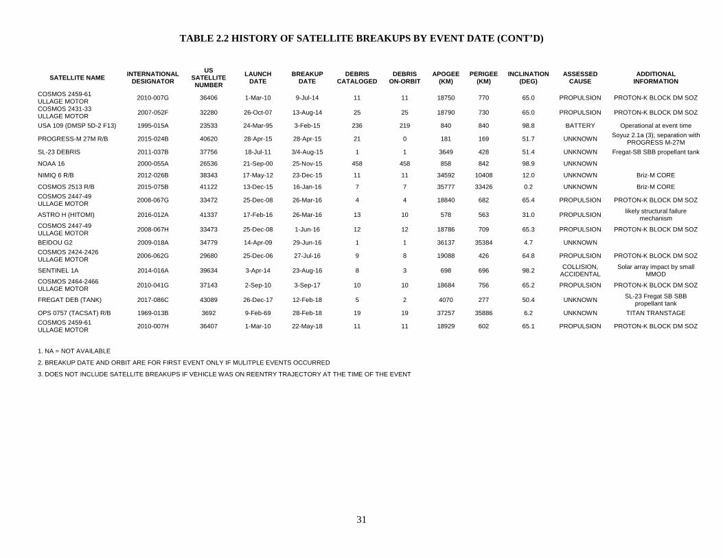
TABLE 2.2 HISTORY OF SATELLITE BREAKUPS BY EVENT DATE (CONT’D)
31
SATELLITE NAME INTERNATIONAL DESIGNATOR
US SATELLITE NUMBER
LAUNCH DATE
BREAKUP DATE
DEBRIS CATALOGED
DEBRIS ON-ORBIT
APOGEE (KM)
PERIGEE (KM)
INCLINATION (DEG)
ASSESSED CAUSE
ADDITIONAL INFORMATION
COSMOS 2459-61 ULLAGE MOTOR 2010-007G 36406 1-Mar-10 9-Jul-14 11 11 18750 770 65.0 PROPULSION PROTON-K BLOCK DM SOZ
COSMOS 2431-33 ULLAGE MOTOR 2007-052F 32280 26-Oct-07 13-Aug-14 25 25 18790 730 65.0 PROPULSION PROTON-K BLOCK DM SOZ
USA 109 (DMSP 5D-2 F13) 1995-015A 23533 24-Mar-95 3-Feb-15 236 219 840 840 98.8 BATTERY Operational at event time
PROGRESS-M 27M R/B 2015-024B 40620 28-Apr-15 28-Apr-15 21 0 181 169 51.7 UNKNOWN Soyuz 2.1a (3); separation with PROGRESS M-27M
SL-23 DEBRIS 2011-037B 37756 18-Jul-11 3/4-Aug-15 1 1 3649 428 51.4 UNKNOWN Fregat-SB SBB propellant tank
NOAA 16 2000-055A 26536 21-Sep-00 25-Nov-15 458 458 858 842 98.9 UNKNOWN
NIMIQ 6 R/B 2012-026B 38343 17-May-12 23-Dec-15 11 11 34592 10408 12.0 UNKNOWN Briz-M CORE
COSMOS 2513 R/B 2015-075B 41122 13-Dec-15 16-Jan-16 7 7 35777 33426 0.2 UNKNOWN Briz-M CORE COSMOS 2447-49 ULLAGE MOTOR 2008-067G 33472 25-Dec-08 26-Mar-16 4 4 18840 682 65.4 PROPULSION PROTON-K BLOCK DM SOZ
ASTRO H (HITOMI) 2016-012A 41337 17-Feb-16 26-Mar-16 13 10 578 563 31.0 PROPULSION likely structural failure mechanism
COSMOS 2447-49 ULLAGE MOTOR 2008-067H 33473 25-Dec-08 1-Jun-16 12 12 18786 709 65.3 PROPULSION PROTON-K BLOCK DM SOZ
BEIDOU G2 2009-018A 34779 14-Apr-09 29-Jun-16 1 1 36137 35384 4.7 UNKNOWN
COSMOS 2424-2426 ULLAGE MOTOR 2006-062G 29680 25-Dec-06 27-Jul-16 9 8 19088 426 64.8 PROPULSION PROTON-K BLOCK DM SOZ
SENTINEL 1A 2014-016A 39634 3-Apr-14 23-Aug-16 8 3 698 696 98.2 COLLISION, ACCIDENTAL
Solar array impact by small MMOD
COSMOS 2464-2466 ULLAGE MOTOR 2010-041G 37143 2-Sep-10 3-Sep-17 10 10 18684 756 65.2 PROPULSION PROTON-K BLOCK DM SOZ
FREGAT DEB (TANK) 2017-086C 43089 26-Dec-17 12-Feb-18 5 2 4070 277 50.4 UNKNOWN SL-23 Fregat SB SBB propellant tank
OPS 0757 (TACSAT) R/B 1969-013B 3692 9-Feb-69 28-Feb-18 19 19 37257 35886 6.2 UNKNOWN TITAN TRANSTAGE COSMOS 2459-61 ULLAGE MOTOR 2010-007H 36407 1-Mar-10 22-May-18 11 11 18929 602 65.1 PROPULSION PROTON-K BLOCK DM SOZ
1. NA = NOT AVAILABLE
2. BREAKUP DATE AND ORBIT ARE FOR FIRST EVENT ONLY IF MULITPLE EVENTS OCCURRED
3. DOES NOT INCLUDE SATELLITE BREAKUPS IF VEHICLE WAS ON REENTRY TRAJECTORY AT THE TIME OF THE EVENT
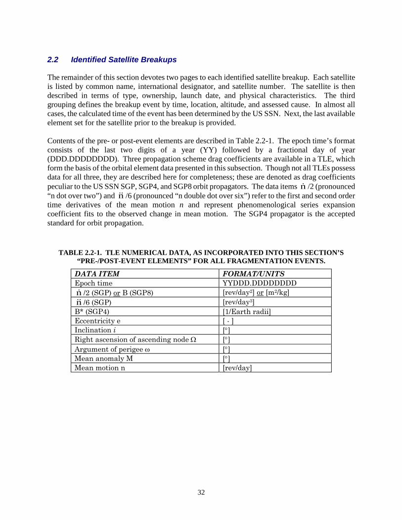
32
2.2 Identified Satellite Breakups The remainder of this section devotes two pages to each identified satellite breakup. Each satellite is listed by common name, international designator, and satellite number. The satellite is then described in terms of type, ownership, launch date, and physical characteristics. The third grouping defines the breakup event by time, location, altitude, and assessed cause. In almost all cases, the calculated time of the event has been determined by the US SSN. Next, the last available element set for the satellite prior to the breakup is provided. Contents of the pre- or post-event elements are described in Table 2.2-1. The epoch time’s format consists of the last two digits of a year (YY) followed by a fractional day of year (DDD.DDDDDDDD). Three propagation scheme drag coefficients are available in a TLE, which form the basis of the orbital element data presented in this subsection. Though not all TLEs possess data for all three, they are described here for completeness; these are denoted as drag coefficients peculiar to the US SSN SGP, SGP4, and SGP8 orbit propagators. The data items n /2 (pronounced “n dot over two”) and n /6 (pronounced “n double dot over six”) refer to the first and second order time derivatives of the mean motion n and represent phenomenological series expansion coefficient fits to the observed change in mean motion. The SGP4 propagator is the accepted standard for orbit propagation.
TABLE 2.2-1. TLE NUMERICAL DATA, AS INCORPORATED INTO THIS SECTION’S “PRE-/POST-EVENT ELEMENTS” FOR ALL FRAGMENTATION EVENTS.
DATA ITEM FORMAT/UNITS Epoch time YYDDD.DDDDDDDD n /2 (SGP) or B (SGP8) [rev/day2] or [m2/kg] n /6 (SGP) [rev/day3] B* (SGP4) [1/Earth radii] Eccentricity e [ - ] Inclination i [°] Right ascension of ascending node Ω [°] Argument of perigee ω [°] Mean anomaly M [°] Mean motion n [rev/day]
33
If the breakup occurred soon after launch or after a maneuver and before an element set could be generated, the most appropriate post-event element set is given. The maximum observed changes in the orbital period (∆P) and inclination (∆I), referenced to the parent's pre-event element set, are then summarized. The reader is reminded that for a given event, the magnitudes of the resultant ∆P and ∆I are a function of the satellite's latitude and altitude. Comparisons of these values from one event to another cannot be made directly. Additionally, inclination changes measure only one portion of the fragmentation orbital plane change. Changes in Right Ascension also occur in most events and can account for some plane change fragmentation energy.
A general summary of the event, actions leading to the event, debris cataloging progress, and evaluations of the event are collected under the Comments heading. Documents that relate directly to the subject breakup or to breakups of satellites of this type are then listed. Gabbard diagrams of the early debris cloud prior to the effects of perturbations, if the data were available, are reconstructed. These diagrams often include uncataloged as well as cataloged debris data. When used correctly, Gabbard diagrams can provide important insights into the features of the fragmentation.
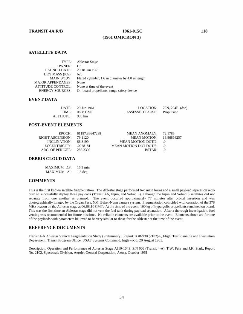
34
TRANSIT 4A R/B 1961-015C 118 (1961 OMICRON 3)
SATELLITE DATA TYPE: Ablestar Stage OWNER: US LAUNCH DATE: 29.18 Jun 1961 DRY MASS (KG): 625 MAIN BODY: Flared cylinder; 1.6 m diameter by 4.8 m length MAJOR APPENDAGES: None ATTITUDE CONTROL: None at time of the event ENERGY SOURCES: On-board propellants, range safety device EVENT DATA DATE: 29 Jun 1961 LOCATION: 28N, 254E (dsc) TIME: 0608 GMT ASSESSED CAUSE: Propulsion ALTITUDE: 990 km POST-EVENT ELEMENTS EPOCH: 61187.36647288 MEAN ANOMALY: 72.1786 RIGHT ASCENSION: 79.1120 MEAN MOTION: 13.86864257 INCLINATION: 66.8199 MEAN MOTION DOT/2: .0 ECCENTRICITY: .0078181 MEAN MOTION DOT DOT/6: .0 ARG. OF PERIGEE: 288.2398 BSTAR: .0 DEBRIS CLOUD DATA MAXIMUM ∆P: 15.5 min MAXIMUM ∆I: 1.3 deg COMMENTS This is the first known satellite fragmentation. The Ablestar stage performed two main burns and a small payload separation retro burn to successfully deploy three payloads (Transit 4A, Injun, and Solrad 3), although the Injun and Solrad 3 satellites did not separate from one another as planned. The event occurred approximately 77 minutes after orbital insertion and was photographically imaged by the Organ Pass, NM, Baker-Nunn camera system. Fragmentation coincided with cessation of the 378 MHz beacon on the Ablestar stage at 06:08:10 GMT. At the time of the event, 100 kg of hypergolic propellants remained on board. This was the first time an Ablestar stage did not vent the fuel tank during payload separation. After a thorough investigation, fuel venting was recommended for future missions. No reliable elements are available prior to the event. Elements above are for one of the payloads with parameters believed to be very similar to those for the Ablestar at the time of the event. REFERENCE DOCUMENTS Transit 4-A Ablestar Vehicle Fragmentation Study (Preliminary), Report TOR-930 (2102)-6, Flight Test Planning and Evaluation Department, Transit Program Office, USAF Systems Command, Inglewood, 28 August 1961. Description, Operation and Performance of Ablestar Stage AJ10-104S, S/N 008 (Transit 4-A), T.W. Fehr and J.K. Stark, Report No. 2102, Spacecraft Division, Aerojet-General Corporation, Azusa, October 1961.

35
Transit 4A R/B debris cloud of 201 cataloged fragments in May 1964 as reconstructed
from the US SSN database.
0
500
1000
1500
2000
2500
90 95 100 105 110 115 120
Apog
ee/P
erig
ee A
ltitu
de (k
m)
Period (min)
Apogee
Perigee
SSN 118
36
SPUTNIK 29 1962-057A 443 (1962-BETA IOTA 1) SATELLITE DATA TYPE: Payload and R/B(s) (?) OWNER: CIS LAUNCH DATE: 24.75 Oct 1962 DRY MASS (KG): 1500 MAIN BODY: Cylinder; 2.6 m diameter by 7.15 m length MAJOR APPENDAGES: None ATTITUDE CONTROL: Unknown at time of event ENERGY SOURCES: On-board propellants EVENT DATA DATE: 29 Oct 1962 LOCATION: Unknown TIME: Unknown ASSESSED CAUSE: Propulsion ALTITUDE: ~200 km PRE-EVENT ELEMENTS EPOCH: 62297.80327270 MEAN ANOMALY: 229.0409 RIGHT ASCENSION: 336.4972 MEAN MOTION: 16.15589719 INCLINATION: 65.1128 MEAN MOTION DOT/2: .01124103 ECCENTRICITY: .0044520 MEAN MOTION DOT DOT/6: .0 ARG. OF PERIGEE: 92.2650 BSTAR: .0 DEBRIS CLOUD DATA MAXIMUM ∆P: Unknown MAXIMUM ∆I: 0.6 deg COMMENTS Sputnik 29 (also known as Sputnik 22) was not acknowledged at launch by the USSR and was probably a Mars probe that failed to leave Earth orbit. This was apparently the fourth orbital failure of the Molniya third stage since 25 August 1962. No Molniya orbital (3rd) stage nor final (4th) stage was cataloged after launch. Possible that orbital and final stages never separated. Sputnik 29 was officially decayed 29 October 1962 but no debris were cataloged before 11 November. Consequently, ∆P cannot be calculated. Source of the fragmentation was probably the fully-fueled Molniya final stage. REFERENCE DOCUMENT History of Soviet/Russian Satellite Fragmentations-A Joint U.S.-Russian Investigation, N. L. Johnson et al, Kaman Sciences Corporation, October 1995.
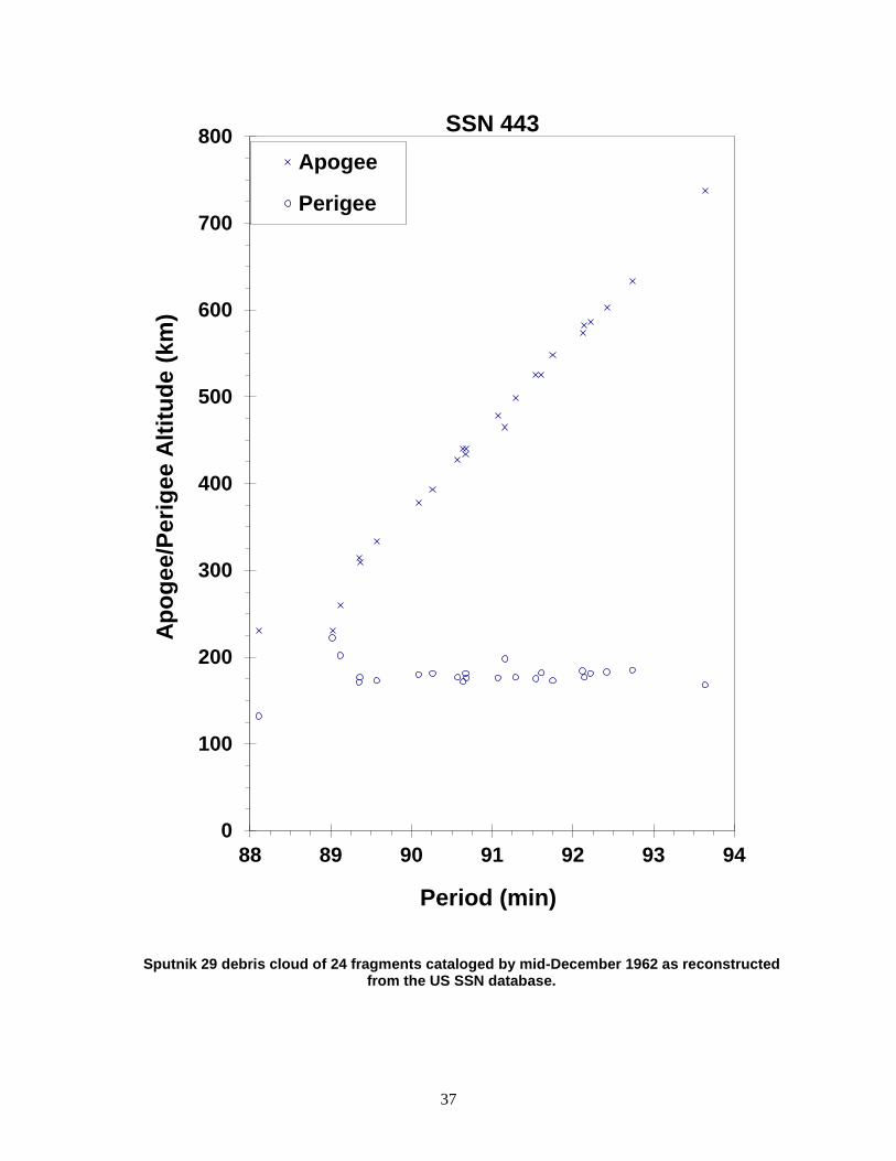
37
Sputnik 29 debris cloud of 24 fragments cataloged by mid-December 1962 as reconstructed from the US SSN database.
0
100
200
300
400
500
600
700
800
88 89 90 91 92 93 94
Apog
ee/P
erig
ee A
ltitu
de (k
m)
Period (min)
Apogee
Perigee
SSN 443

38
ATLAS CENTAUR 2 1963-047A 694 SATELLITE DATA TYPE: Centaur Stage OWNER: US LAUNCH DATE: 27.79 Nov 1963 DRY MASS (KG): 4600 MAIN BODY: Cylinder; 3 m diameter by 9 m length MAJOR APPENDAGES: None ATTITUDE CONTROL: Unknown at time of the event ENERGY SOURCES: Unknown EVENT DATA DATE: 27 Nov 1963 LOCATION: Unknown TIME: Unknown ASSESSED CAUSE: Propulsion ALTITUDE: Unknown POST-EVENT ELEMENTS EPOCH: 63336.85832214 MEAN ANOMALY: 213.1623 RIGHT ASCENSION: 135.1828 MEAN MOTION: 13.34437775 INCLINATION: 30.3440 MEAN MOTION DOT/2: .00003262 ECCENTRICITY: .0869282 MEAN MOTION DOT DOT/6: .0 ARG. OF PERIGEE: 151.8246 BSTAR: .0 DEBRIS CLOUD DATA MAXIMUM ∆P: 0.9 min MAXIMUM ∆I: 0.4 deg COMMENTS First Centaur stage to reach Earth orbit. No payload was carried. After orbital insertion, residual liquid hydrogen vaporized, resulting in an increase in tank pressurization. Venting via an aft tube then induced a pin-wheel tumble that reached 48 rpm a little more than 1 hour after launch. At the beginning of the third orbit insulation blankets around the Centaur stage were thrown off. Subsequent Centaur missions were not subject to this phenomenon that was caused by the unique configuration of Atlas Centaur 2. First six fragments were cataloged within 1 week of launch. Centaur stage retains large radar cross-section, while all debris are substantially smaller. REFERENCE DOCUMENT Supplementary Information on AC-2 Post-Injection Flight Events, W.S. Hicks, Memorandum BXN63-521, 27 December 1963.
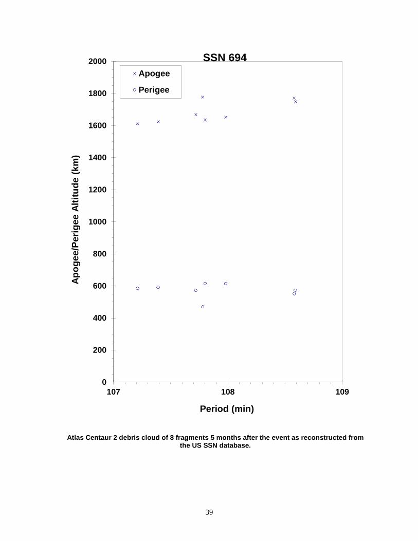
39
Atlas Centaur 2 debris cloud of 8 fragments 5 months after the event as reconstructed from the US SSN database.
0
200
400
600
800
1000
1200
1400
1600
1800
2000
107 108 109
Apog
ee/P
erig
ee A
ltitu
de (k
m)
Period (min)
Apogee
Perigee
SSN 694
40
COSMOS 50 1964-070A 919 SATELLITE DATA TYPE: Payload OWNER: CIS LAUNCH DATE: 28.45 Oct 1964 DRY MASS (KG): 4750 MAIN BODY: Sphere-cylinder; 2.4 m diameter by 4.3 m length MAJOR APPENDAGES: None ATTITUDE CONTROL: Active, 3-axis ENERGY SOURCES: On-board propellants, 10 kg TNT explosive charge EVENT DATA DATE: 5 Nov 1964 LOCATION: Unknown TIME: Unknown ASSESSED CAUSE: Deliberate ALTITUDE: ~200 km PRE-EVENT ELEMENTS EPOCH: 64303.72916435 MEAN ANOMALY: 46.7488 RIGHT ASCENSION: 198.5952 MEAN MOTION: 16.23335350 INCLINATION: 51.2318 MEAN MOTION DOT/2: .00269057 ECCENTRICITY: .0034483 MEAN MOTION DOT DOT/6: .0 ARG. OF PERIGEE: 312.9624 BSTAR: .0 DEBRIS CLOUD DATA MAXIMUM ∆P: Unknown MAXIMUM ∆I: Unknown COMMENTS Spacecraft was destroyed after a malfunction prevented reentry and landing in the Soviet Union. Event occurred on the anticipated day of recovery. All debris were cataloged without elements. A probable fragment from this event reentered on 12 November 1964, landing in Malawi. See cited reference below. REFERENCE DOCUMENTS The Examination of a Sample of Space Debris, P.H.H. Bishop and K.F. Rogers, Technical Report 65165, Royal Aircraft Establishment, Farnborough Hants, August 1965. History of Soviet/Russian Satellite Fragmentations-A Joint U.S.-Russian Investigation, N. L. Johnson et al, Kaman Sciences Corporation, October 1995.

41
Insufficient data to construct a Gabbard diagram.
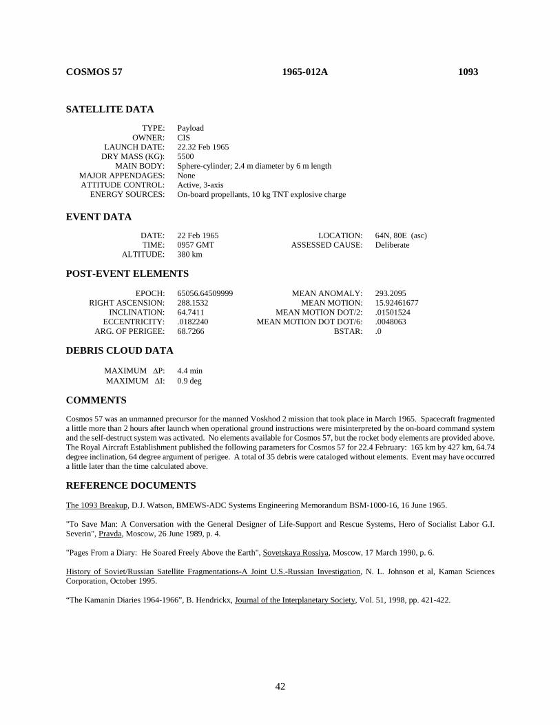
42
COSMOS 57 1965-012A 1093 SATELLITE DATA TYPE: Payload OWNER: CIS LAUNCH DATE: 22.32 Feb 1965 DRY MASS (KG): 5500 MAIN BODY: Sphere-cylinder; 2.4 m diameter by 6 m length MAJOR APPENDAGES: None ATTITUDE CONTROL: Active, 3-axis ENERGY SOURCES: On-board propellants, 10 kg TNT explosive charge EVENT DATA DATE: 22 Feb 1965 LOCATION: 64N, 80E (asc) TIME: 0957 GMT ASSESSED CAUSE: Deliberate ALTITUDE: 380 km POST-EVENT ELEMENTS EPOCH: 65056.64509999 MEAN ANOMALY: 293.2095 RIGHT ASCENSION: 288.1532 MEAN MOTION: 15.92461677 INCLINATION: 64.7411 MEAN MOTION DOT/2: .01501524 ECCENTRICITY: .0182240 MEAN MOTION DOT DOT/6: .0048063 ARG. OF PERIGEE: 68.7266 BSTAR: .0 DEBRIS CLOUD DATA MAXIMUM ∆P: 4.4 min MAXIMUM ∆I: 0.9 deg COMMENTS Cosmos 57 was an unmanned precursor for the manned Voskhod 2 mission that took place in March 1965. Spacecraft fragmented a little more than 2 hours after launch when operational ground instructions were misinterpreted by the on-board command system and the self-destruct system was activated. No elements available for Cosmos 57, but the rocket body elements are provided above. The Royal Aircraft Establishment published the following parameters for Cosmos 57 for 22.4 February: 165 km by 427 km, 64.74 degree inclination, 64 degree argument of perigee. A total of 35 debris were cataloged without elements. Event may have occurred a little later than the time calculated above. REFERENCE DOCUMENTS The 1093 Breakup, D.J. Watson, BMEWS-ADC Systems Engineering Memorandum BSM-1000-16, 16 June 1965. "To Save Man: A Conversation with the General Designer of Life-Support and Rescue Systems, Hero of Socialist Labor G.I. Severin", Pravda, Moscow, 26 June 1989, p. 4. "Pages From a Diary: He Soared Freely Above the Earth", Sovetskaya Rossiya, Moscow, 17 March 1990, p. 6. History of Soviet/Russian Satellite Fragmentations-A Joint U.S.-Russian Investigation, N. L. Johnson et al, Kaman Sciences Corporation, October 1995. “The Kamanin Diaries 1964-1966”, B. Hendrickx, Journal of the Interplanetary Society, Vol. 51, 1998, pp. 421-422.
43
Cosmos 57 debris cloud of 133 fragments cataloged within 1 month of the event as reconstructed from the US SSN database.
0
100
200
300
400
500
600
700
87 88 89 90 91 92 93
Apog
ee/P
erig
ee A
ltitu
de (k
m)
Period (min)
Apogee
Perigee
SSN 1093
44
COSMOS 61-63 R/B 1965-020D 1270 SATELLITE DATA TYPE: Cosmos Second Stage OWNER: CIS LAUNCH DATE: 15.46 Mar 1965 DRY MASS (KG): 1600 MAIN BODY: Cylinder; 2.4 m diameter by 5 m length MAJOR APPENDAGES: None ATTITUDE CONTROL: None at time of the event. ENERGY SOURCES: Unknown EVENT DATA DATE: 15 Mar 1965 LOCATION: 51S, 162E (dsc) TIME: 1714 GMT ASSESSED CAUSE: Unknown ALTITUDE: 1640 km POST-EVENT ELEMENTS EPOCH: 65074.89183830 MEAN ANOMALY: 265.7165 RIGHT ASCENSION: 357.3218 MEAN MOTION: 13.57884745 INCLINATION: 56.0538 MEAN MOTION DOT/2: .00231832 ECCENTRICITY: .1056119 MEAN MOTION DOT DOT/6: .0 ARG. OF PERIGEE: 106.1560 BSTAR: .0 DEBRIS CLOUD DATA MAXIMUM ∆P: 10.3 min MAXIMUM ∆I: 0.4 deg COMMENTS This is the first confirmed case of the fragmentation of the Cosmos 3 (SL-8 or C-1) second stage. This was the third mission to deploy three payloads and was a repeat of the Cosmos 54-56 mission 3 weeks earlier. The event occurred a little more than 6 hours after the successful deployment of the three payloads. Elements above are the first developed for the rocket body and are about 4 hours after the event. Official debris cataloging did not begin for 6 weeks. REFERENCE DOCUMENTS "Fragmentations of Asteroids and Artificial Satellites in Orbit", W. Wiesel, Icarus, Vol. 34, 1978, pp. 99-116. History of Soviet/Russian Satellite Fragmentations-A Joint U.S.-Russian Investigation, N. L. Johnson et al, Kaman Sciences Corporation, October 1995.
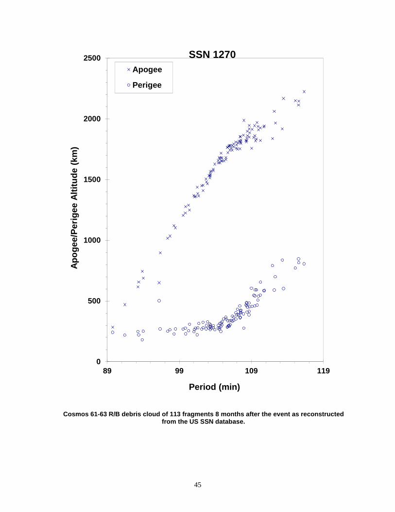
45
Cosmos 61-63 R/B debris cloud of 113 fragments 8 months after the event as reconstructed from the US SSN database.
0
500
1000
1500
2000
2500
89 99 109 119
Apog
ee/P
erig
ee A
ltitu
de (k
m)
Period (min)
Apogee
Perigee
SSN 1270

46
COSMOS 95 1965-088A 1706 SATELLITE DATA TYPE: Payload OWNER: CIS LAUNCH DATE: 4.23 Nov 1965 DRY MASS (KG): 400 MAIN BODY: Ellipsoid; 1.2 m diameter by 1.8 m length MAJOR APPENDAGES: Unknown ATTITUDE CONTROL: Unknown ENERGY SOURCES: Unknown EVENT DATA DATE: 15 Jan 1966 LOCATION: Unknown TIME: Unknown ASSESSED CAUSE: Unknown ALTITUDE: Unknown PRE-EVENT ELEMENTS EPOCH: 66009.5 MEAN ANOMALY: Unknown RIGHT ASCENSION: Unknown MEAN MOTION: 16.09757275 INCLINATION: 48.39 MEAN MOTION DOT/2: Unknown ECCENTRICITY: 0.009282 MEAN MOTION DOT DOT/6: Unknown ARG. OF PERIGEE: 77 BSTAR: Unknown DEBRIS CLOUD DATA MAXIMUM ∆P: Unknown MAXIMUM ∆I: Unknown COMMENTS Pre-event elements were taken from RAE Table of Earth Satellites. Cosmos 95 was placed into a low Earth orbit on 4 November 1965. Within 2 weeks nearly two dozen debris had been detected and were later cataloged. However, the nature of the debris, i.e. breakup versus operational, was not determined. The last of these debris decayed naturally by 6 January 1966. Russian records indicate that a breakup may have occurred on 15 January 1966, 3 days before the 400 kg spacecraft itself reentered. No other information on this event has been discovered, and no debris remains in orbit. REFERENCE DOCUMENT History of Soviet/Russian Satellite Fragmentations-A Joint U.S.-Russian Investigation, N. L. Johnson et al, Kaman Sciences Corporation, October 1995.

47
Insufficient data to construct a Gabbard diagram.
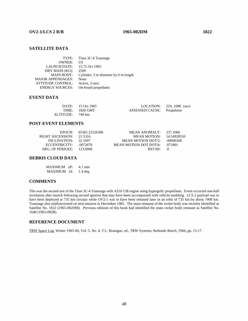
48
OV2-1/LCS 2 R/B 1965-082DM 1822 SATELLITE DATA TYPE: Titan 3C-4 Transtage OWNER: US LAUNCH DATE: 15.72 Oct 1965 DRY MASS (KG): 2500 MAIN BODY: Cylinder; 3 m diameter by 6 m length MAJOR APPENDAGES: None ATTITUDE CONTROL: Active, 3-axis ENERGY SOURCES: On-board propellants EVENT DATA DATE: 15 Oct 1965 LOCATION: 22S, 108E (asc) TIME: 1820 GMT ASSESSED CAUSE: Propulsion ALTITUDE: 740 km POST-EVENT ELEMENTS EPOCH: 65361.23126396 MEAN ANOMALY: 237.1066 RIGHT ASCENSION: 21.5316 MEAN MOTION: 14.54928550 INCLINATION: 32.1697 MEAN MOTION DOT/2: .00000268 ECCENTRICITY: .0072678 MEAN MOTION DOT DOT/6: .071801 ARG. OF PERIGEE: 123.6068 BSTAR: .0 DEBRIS CLOUD DATA MAXIMUM ∆P: 4.1 min MAXIMUM ∆I: 1.4 deg COMMENTS This was the second test of the Titan 3C-4 Transtage with AJ10-138 engine using hypergolic propellants. Event occurred one-half revolution after launch following second ignition that may have been accompanied with vehicle tumbling. LCS 2 payload was to have been deployed at 735 km circular while OV2-1 was to have been released later in an orbit of 735 km by about 7400 km. Transtage also malfunctioned on next mission in December 1965. The main remnant of the rocket body was recently identified as Satellite No. 1822 (1965-082DM). Previous editions of this book had identified the main rocket body remnant as Satellite No. 1640 (1965-082B). REFERENCE DOCUMENT TRW Space Log, Winter 1965-66, Vol. 5, No. 4, T.L. Branigan, ed., TRW Systems, Redondo Beach, 1966, pp. 15-17.
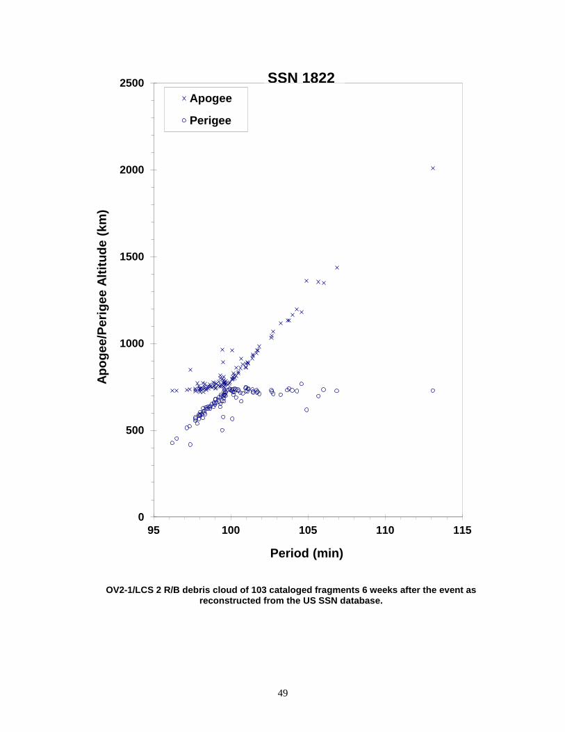
49
OV2-1/LCS 2 R/B debris cloud of 103 cataloged fragments 6 weeks after the event as reconstructed from the US SSN database.
0
500
1000
1500
2000
2500
95 100 105 110 115
Apog
ee/P
erig
ee A
ltitu
de (k
m)
Period (min)
Apogee
Perigee
SSN 1822

50
OV2-3/LES-3,-4/OSCAR 4 R/B 1965-108A 1863 SATELLITE DATA TYPE: Titan IIIC Transtage Rocket Body OWNER: US LAUNCH DATE: 21 Dec 1965 DRY MASS (KG): 2,555 MAIN BODY: 3.048 m diameter x ~5 m long right circular cylinder MAJOR APPENDAGES: none ATTITUDE CONTROL: 3-axis ENERGY SOURCES: on-board propellants; pressure vessels; chemical batteries EVENT DATA DATE: 21 Dec 1965 LOCATION: unknown TIME: unknown ASSESSED CAUSE: Propulsion ALTITUDE: unknown POST-EVENT ELEMENTS EPOCH: 69013.84962483 MEAN ANOMALY: 2.6587 RIGHT ASCENSION: 206.0825 MEAN MOTION: 4.07936348 INCLINATION: 26.4899 MEAN MOTION DOT/2: 0.00014521 ECCENTRICITY: 0.6007336 MEAN MOTION DOT DOT/6: 0.00000 ARG. OF PERIGEE: 346.5872 BSTAR: 0.0097405 DEBRIS CLOUD DATA MAXIMUM ∆P: unknown MAXIMUM ∆I: unknown COMMENTS The cause of this event is assessed to be propulsion-related. The 13th ed. of the History of On-Orbit Satellite Fragmentations described this event as a provisional fragmentation. REFERENCE DOCUMENT
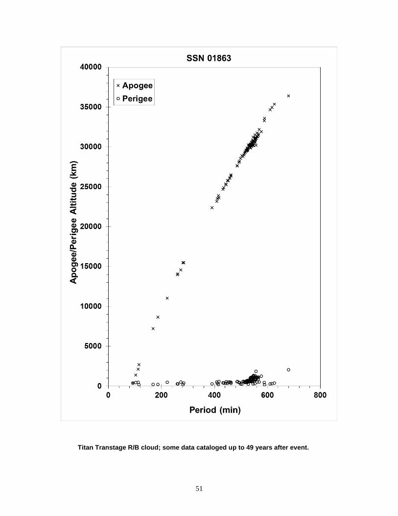
51
Titan Transtage R/B cloud; some data cataloged up to 49 years after event.
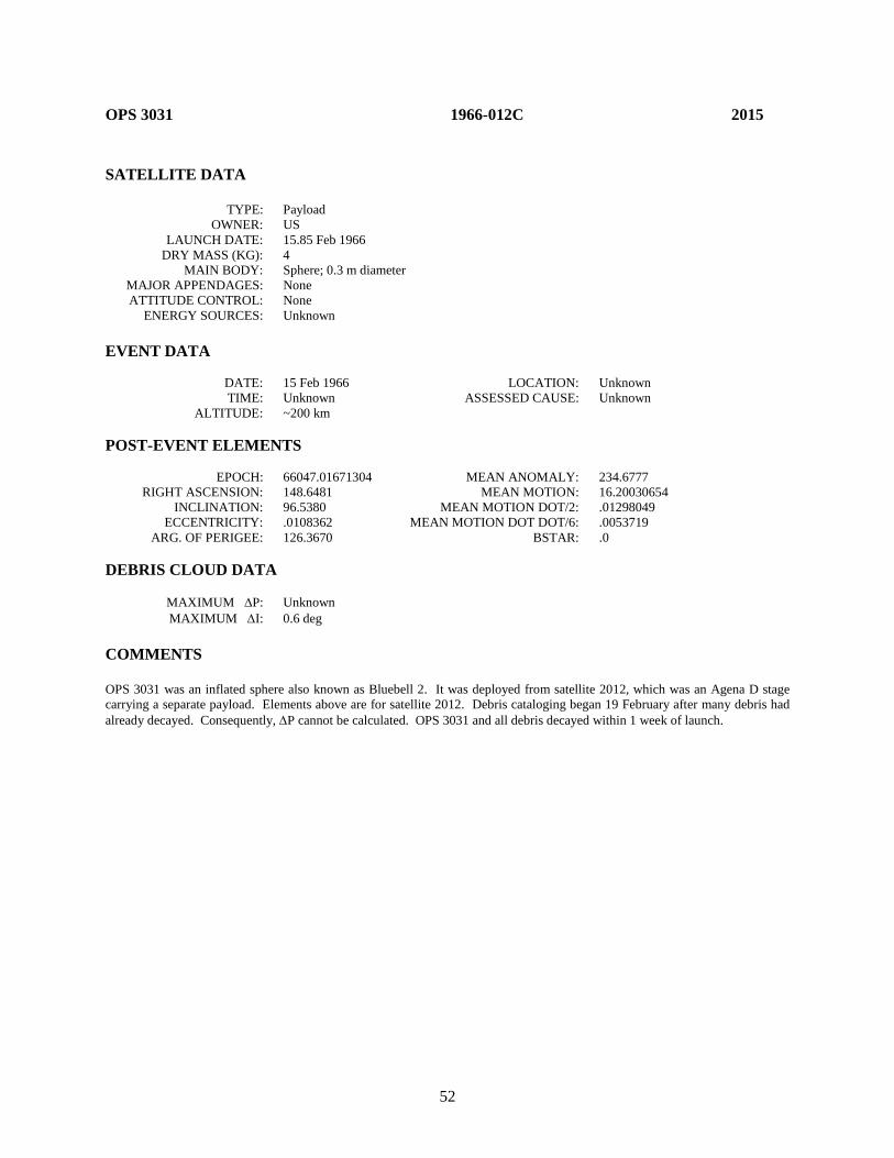
52
OPS 3031 1966-012C 2015 SATELLITE DATA TYPE: Payload OWNER: US LAUNCH DATE: 15.85 Feb 1966 DRY MASS (KG): 4 MAIN BODY: Sphere; 0.3 m diameter MAJOR APPENDAGES: None ATTITUDE CONTROL: None ENERGY SOURCES: Unknown EVENT DATA DATE: 15 Feb 1966 LOCATION: Unknown TIME: Unknown ASSESSED CAUSE: Unknown ALTITUDE: ~200 km POST-EVENT ELEMENTS EPOCH: 66047.01671304 MEAN ANOMALY: 234.6777 RIGHT ASCENSION: 148.6481 MEAN MOTION: 16.20030654 INCLINATION: 96.5380 MEAN MOTION DOT/2: .01298049 ECCENTRICITY: .0108362 MEAN MOTION DOT DOT/6: .0053719 ARG. OF PERIGEE: 126.3670 BSTAR: .0 DEBRIS CLOUD DATA MAXIMUM ∆P: Unknown MAXIMUM ∆I: 0.6 deg COMMENTS OPS 3031 was an inflated sphere also known as Bluebell 2. It was deployed from satellite 2012, which was an Agena D stage carrying a separate payload. Elements above are for satellite 2012. Debris cataloging began 19 February after many debris had already decayed. Consequently, ∆P cannot be calculated. OPS 3031 and all debris decayed within 1 week of launch.
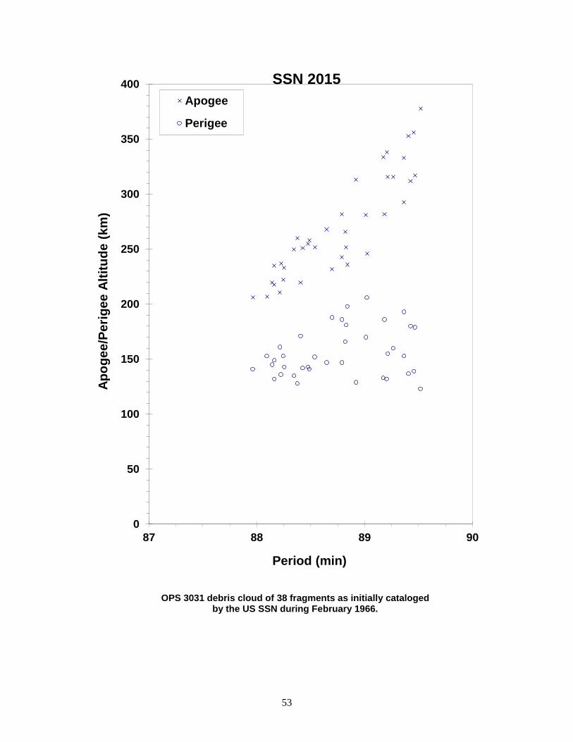
53
OPS 3031 debris cloud of 38 fragments as initially cataloged by the US SSN during February 1966.
0
50
100
150
200
250
300
350
400
87 88 89 90
Apog
ee/P
erig
ee A
ltitu
de (k
m)
Period (min)
Apogee
Perigee
SSN 2015

54
GEMINI 9 ATDA R/B 1966-046B 2188 SATELLITE DATA TYPE: Atlas Core Stage OWNER: US LAUNCH DATE: 1.63 Jun 1966 DRY MASS (KG): 3400 MAIN BODY: Cylinder; 3 m diameter by 20 m length MAJOR APPENDAGES: None ATTITUDE CONTROL: None at time of the event. ENERGY SOURCES: Unknown EVENT DATA DATE: Mid-Jun 1966 LOCATION: Unknown TIME: Unknown ASSESSED CAUSE: Unknown ALTITUDE ~250 km PRE-EVENT ELEMENTS EPOCH: 66164.96883397 MEAN ANOMALY: 224.9775 RIGHT ASCENSION: 223.9064 MEAN MOTION: 16.05545399 INCLINATION: 28.7968 MEAN MOTION DOT/2: .00654808 ECCENTRICITY: .0025152 MEAN MOTION DOT DOT/6: .0010778 ARG. OF PERIGEE: 135.2510 BSTAR: .0 DEBRIS CLOUD DATA MAXIMUM ∆P: 5.5 min MAXIMUM ∆I: 1.5 deg COMMENTS This stage successfully deployed the Augmented Target Docking Adapter (ATDA) for the Gemini 9 mission. The elements above are the last available for the rocket body. Debris cataloging began on 21 June. Debris decay dates ranged from 21 June to 4 July with the rocket body officially decaying on 22 June. A review of NASA archives for this mission revealed no documented anomaly with the Atlas booster. Discussions in 1989 with General Dynamics personnel involved in the mission (Mr. Phil Genser of General Dynamics, San Diego) also failed to uncover any knowledge of the event. Pressure relief valves should have relieved pressurization increases, particularly in the oxygen tank. Possible failure of the oxygen relief valve could not be ruled out.

55
Gemini 9 ATDA R/B debris cloud of 24 fragments cataloged between 21 and 24 June as reconstructed from the US SSN database.
0
100
200
300
400
500
600
88 89 90 91 92 93
Apog
ee/P
erig
ee A
ltitu
de (k
m)
Period (min)
Apogee
Perigee
SSN 2188

56
PAGEOS 1966-056A 2253 SATELLITE DATA TYPE: Payload OWNER: US LAUNCH DATE: 24.01 Jun 1966 DRY MASS (KG): 55 MAIN BODY: Sphere; 30 m diameter MAJOR APPENDAGES: None ATTITUDE CONTROL: None ENERGY SOURCES: None EVENT DATA (1) DATE: 12 Jul 1975 LOCATION: 67N, 135E (dsc) TIME: 2248 GMT ASSESSED CAUSE: Unknown ALTITUDE: 5145 km PRE-EVENT ELEMENTS (1) EPOCH: 75192.78059719 MEAN ANOMALY: 67.9594 RIGHT ASCENSION: 238.7429 MEAN MOTION: 7.99684492 INCLINATION: 85.2811 MEAN MOTION DOT/2: .00001217 ECCENTRICITY: .0931904 MEAN MOTION DOT DOT/6: .0 ARG. OF PERIGEE: 281.8264 BSTAR: .77087 EVENT DATA (2) DATE: 20 Jan 1976 LOCATION: Unknown TIME: Unknown ASSESSED CAUSE: Unknown ALTITUDE: Unknown PRE-EVENT ELEMENTS (2) EPOCH: 76019.86486339 MEAN ANOMALY: 305.5539 RIGHT ASCENSION: 209.8639 MEAN MOTION: 8.00368182 INCLINATION: 85.0720 MEAN MOTION DOT/2: .0 ECCENTRICITY: .1179567 MEAN MOTION DOT DOT/6: .0 ARG. OF PERIGEE: 66.4633 BSTAR: .0 DEBRIS CLOUD DATA MAXIMUM ∆P: 0.1 min* MAXIMUM ∆I: 0.7 deg* *Based on 1st event data COMMENTS PAGEOS (Passive Geodetic Earth-Orbiting Satellite) was an inflated balloon made of thin Mylar with an aluminum coating. The first fragmentation event occurred 9 years after launch and resulted in 11 new cataloged objects. The second event was detected by D.G. King-Hele of the RAE, and NAVSPASUR confirmed 44 additional fragments. By August 1976 no additional debris had been cataloged but 19 objects were being tracked in orbits with mean motions near 8 and eccentricities between 0.16 and 0.34. Due to the character of PAGEOS and its subsequent debris, natural perturbations had little effect on orbital period but strongly increased eccentricity by simultaneously lowering perigee and raising apogee. About 10 September 1976 one of the 19 unofficial objects is believed to have broken up into perhaps more than 250 new pieces, none of which were cataloged prior to reentry. Eighteen objects were later cataloged during 7-8 October 1976. On the first anniversary of the second fragmentation (20 Jan 1977), 45 fragments were cataloged without elements and immediately decayed administratively. Additional fragmentations are suspected

57
to have taken place in June 1978, September 1984, and December 1985. Historically, radar tracking of PAGEOS debris has been extremely difficult and cross-tagging frequent. Cause for the second and subsequent events may be material deterioration under environmental stress. A suspected PAGEOS fragment, SSN 5994, which was cataloged as a Westford Needles object, fragmented on 8 September 1995 and again on 14 September 1995 with 12 associated objects. REFERENCE DOCUMENT Spacetrack System Data Related to Some Non-Routine Events Through May 1981, J.R. Gabbard, Technical Memorandum 81-6, DCS/Plans, Hdqtrs NORAD/ADCOM, Colorado Springs, 30 June 1981.
PAGEOS debris cloud of 12 fragments 5 weeks after the first event as reconstructed from the US SSN database.
2000
2500
3000
3500
4000
4500
5000
5500
6000
6500
179 180 181
Apo
gee/
Perig
ee A
ltitu
de (k
m)
Period (min)
Apogee
Perigee
SSN 2253

58
AS-203 1966-059A 2289 SATELLITE DATA TYPE: Saturn SIVB Stage OWNER: US LAUNCH DATE: 5.62 Jul 1966 DRY MASS (KG): 26,600 MAIN BODY: Cylinder; 6.6 m diameter by 28.3 m length MAJOR APPENDAGES: None ATTITUDE CONTROL: Active, 3-axis ENERGY SOURCES: Attitude control and pressurization systems EVENT DATA DATE: 5 Jul 1966 LOCATION: 20N, 277E (dsc) TIME: 2111 GMT ASSESSED CAUSE: Deliberate ALTITUDE: 205 km PRE-EVENT ELEMENTS EPOCH: 66186.73481847 MEAN ANOMALY: 353.9219 RIGHT ASCENSION: 5.5870 MEAN MOTION: 16.27379993 INCLINATION: 31.9810 MEAN MOTION DOT/2: .03796193 ECCENTRICITY: .0022272 MEAN MOTION DOT DOT/6: .17429 ARG. OF PERIGEE: 6.1632 BSTAR: .0 DEBRIS CLOUD DATA MAXIMUM ∆P: 3.5 min MAXIMUM ∆I: 1.4 deg COMMENTS This was the second flight of the SIVB stage. After orbital insertion, the vehicle was intentionally subjected to dynamic integrity tests, including high gravity loadings during attitude control maneuvers and high pressure tests. The vehicle finally broke up after exceeding structural design limits with a propellant tank bulkhead differential pressure in excess of 23.7 N/cm2. The fragmentation occurred early on the fifth revolution. Elements for the first fragments were not cataloged until 8 July. REFERENCE DOCUMENT Saturn AS-203 Evaluation Bulletin, No. 2, R-AERO-F-142-66, J.P. Lindberg, NASA Marshall Space Flight Center, Alabama, 21 July 1966.

59
AS-203 debris cloud of 25 fragments using orbits developed within 1 week of the event as reconstructed from the US SSN database.
0
100
200
300
400
500
600
700
88 89 90 91 92
Apog
ee/P
erig
ee A
ltitu
de (k
m)
Period (min)
Apogee
Perigee
SSN 2289

60
COSMOS U-1 1966-088A 2437 SATELLITE DATA TYPE: Unknown OWNER: CIS LAUNCH DATE: 17.94 Sep 1966 DRY MASS (KG): Unknown MAIN BODY: Cone-cylinder; 1.5 m diameter by 6 m length MAJOR APPENDAGES: None ATTITUDE CONTROL: Unknown ENERGY SOURCES: Explosive device EVENT DATA DATE: 17 Sep 1966 LOCATION: Unknown TIME: Unknown ASSESSED CAUSE: Deliberate ALTITUDE: ~300 km POST-EVENT ELEMENTS EPOCH: 66261.0 MEAN ANOMALY: 283 RIGHT ASCENSION: 338 MEAN MOTION: 14.879 INCLINATION: 49.63 MEAN MOTION DOT/2: .0 ECCENTRICITY: .063 MEAN MOTION DOT DOT/6: .0 ARG. OF PERIGEE: 83 BSTAR: .0 DEBRIS CLOUD DATA MAXIMUM ∆P: Unknown MAXIMUM ∆I: Unknown COMMENTS This was the first of two missions of this type flown in 1966 and not acknowledged by the USSR. The identity of the parent orbit is uncertain. Satellite 2437 was the first cataloged fragment. The above elements are taken or derived from the RAE Table of Earth Satellites. The debris distribution is consistent with a fragmentation near 300 km. Failure of the payload led to immediate activation of the self-destruct system. REFERENCE DOCUMENT History of Soviet/Russian Satellite Fragmentations-A Joint U.S.-Russian Investigation, N. L. Johnson et al, Kaman Sciences Corporation, October 1995.
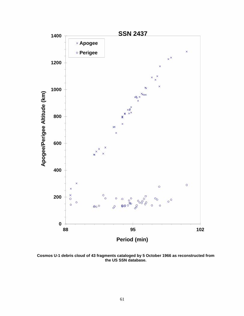
61
Cosmos U-1 debris cloud of 43 fragments cataloged by 5 October 1966 as reconstructed from the US SSN database.
0
200
400
600
800
1000
1200
1400
88 95 102
Apog
ee/P
erig
ee A
ltitu
de (k
m)
Period (min)
Apogee
Perigee
SSN 2437

62
COSMOS U-2 1966-101A 2536 SATELLITE DATA TYPE: Unknown OWNER: CIS LAUNCH DATE: 2.03 Nov 1966 DRY MASS (KG): Unknown MAIN BODY: Cone-cylinder; 1.5 m diameter by 6 m length MAJOR APPENDAGES: None ATTITUDE CONTROL: Unknown ENERGY SOURCES: Explosive device EVENT DATA DATE: 2 Nov 1966 LOCATION: Unknown TIME: Unknown ASSESSED CAUSE: Deliberate ALTITUDE: ~225 km POST-EVENT ELEMENTS EPOCH: 66309.99121234 MEAN ANOMALY: 265.7893 RIGHT ASCENSION: 35.2944 MEAN MOTION: 15.17033022 INCLINATION: 49.5617 MEAN MOTION DOT/2: .01866914 ECCENTRICITY: .05339049 MEAN MOTION DOT DOT/6: .0043309 ARG. OF PERIGEE: 100.3324 BSTAR: .0 DEBRIS CLOUD DATA MAXIMUM ∆P: Unknown MAXIMUM ∆I: Unknown COMMENTS This was the second mission of this type flown in 1966 and not acknowledged by the USSR. No elements were cataloged until 3 days after the launch. The identity of the parent orbit is uncertain. Satellite 2536 was the first object cataloged and was near the center of the debris cloud. The debris distribution is consistent with a fragmentation near 225 km. Failure of the payload led to immediate activation of the self-destruct system. REFERENCE DOCUMENT History of Soviet/Russian Satellite Fragmentations-A Joint U.S.-Russian Investigation, N. L. Johnson et al, Kaman Sciences Corporation, October 1995.

63
Cosmos U-2 debris cloud composed of 14 different orbits as developed by the US SSN within 1 week of the event.
0
500
1000
1500
2000
90 95 100 105 110
Apog
ee/P
erig
ee A
ltitu
de (k
m)
Period (min)
Apogee
Perigee
SSN 2536
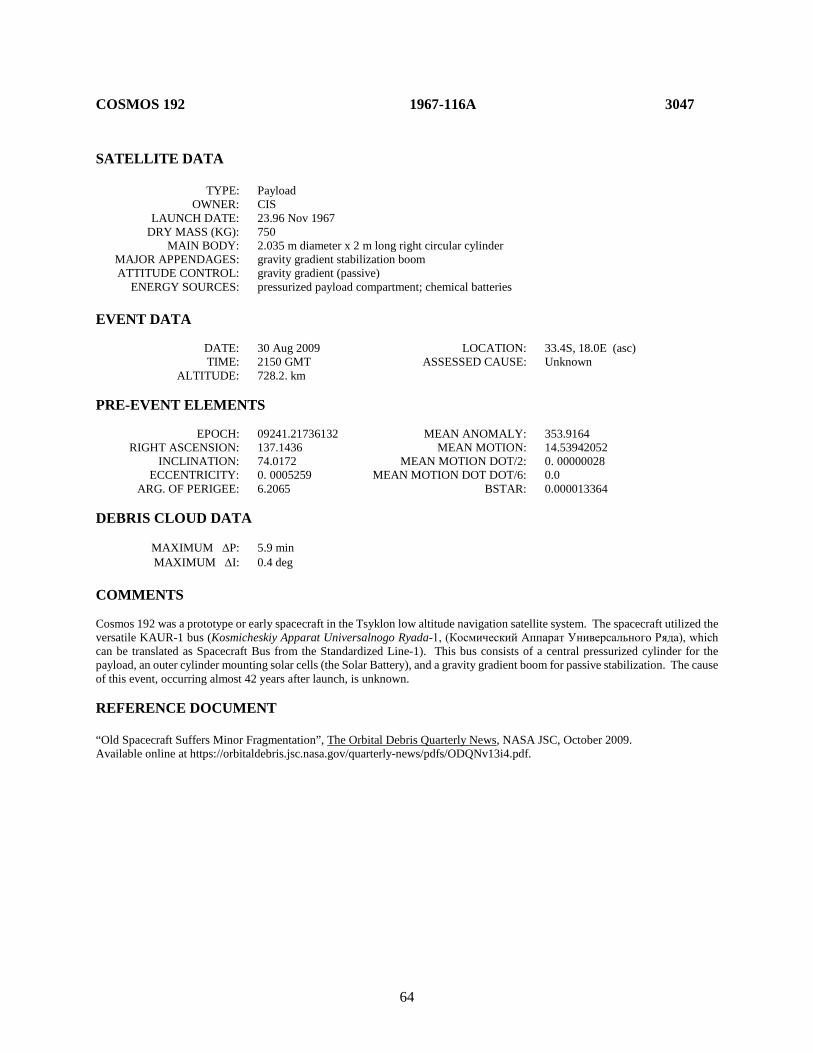
64
COSMOS 192 1967-116A 3047 SATELLITE DATA TYPE: Payload OWNER: CIS LAUNCH DATE: 23.96 Nov 1967 DRY MASS (KG): 750 MAIN BODY: 2.035 m diameter x 2 m long right circular cylinder MAJOR APPENDAGES: gravity gradient stabilization boom ATTITUDE CONTROL: gravity gradient (passive) ENERGY SOURCES: pressurized payload compartment; chemical batteries EVENT DATA DATE: 30 Aug 2009 LOCATION: 33.4S, 18.0E (asc) TIME: 2150 GMT ASSESSED CAUSE: Unknown ALTITUDE: 728.2. km PRE-EVENT ELEMENTS EPOCH: 09241.21736132 MEAN ANOMALY: 353.9164 RIGHT ASCENSION: 137.1436 MEAN MOTION: 14.53942052 INCLINATION: 74.0172 MEAN MOTION DOT/2: 0. 00000028 ECCENTRICITY: 0. 0005259 MEAN MOTION DOT DOT/6: 0.0 ARG. OF PERIGEE: 6.2065 BSTAR: 0.000013364 DEBRIS CLOUD DATA MAXIMUM ∆P: 5.9 min MAXIMUM ∆I: 0.4 deg COMMENTS Cosmos 192 was a prototype or early spacecraft in the Tsyklon low altitude navigation satellite system. The spacecraft utilized the versatile KAUR-1 bus (Kosmicheskiy Apparat Universalnogo Ryada-1, (Космический Аппарат Универсального Ряда), which can be translated as Spacecraft Bus from the Standardized Line-1). This bus consists of a central pressurized cylinder for the payload, an outer cylinder mounting solar cells (the Solar Battery), and a gravity gradient boom for passive stabilization. The cause of this event, occurring almost 42 years after launch, is unknown. REFERENCE DOCUMENT “Old Spacecraft Suffers Minor Fragmentation”, The Orbital Debris Quarterly News, NASA JSC, October 2009. Available online at https://orbitaldebris.jsc.nasa.gov/quarterly-news/pdfs/ODQNv13i4.pdf.
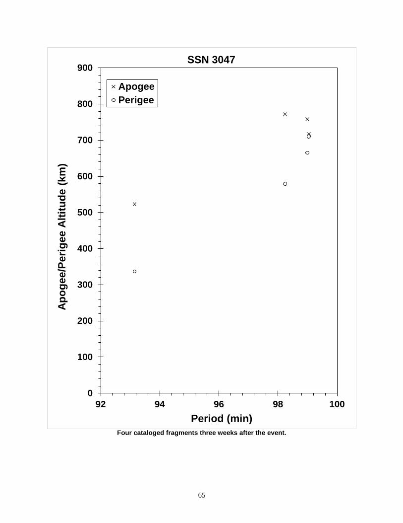
65
Four cataloged fragments three weeks after the event.
0
100
200
300
400
500
600
700
800
900
92 94 96 98 100
Apog
ee/P
erig
ee A
ltitu
de (k
m)
Period (min)
SSN 3047
ApogeePerigee

66
COSMOS 199 1968-003A 3099 SATELLITE DATA TYPE: Payload OWNER: CIS LAUNCH DATE: 16.50 Jan 1968 DRY MASS (KG): 5500 MAIN BODY: Sphere-cylinder; 2.4 m diameter by 6.0 m length MAJOR APPENDAGES: None ATTITUDE CONTROL: Active, 3-axis ENERGY SOURCES: On-board propellants, 10 kg TNT explosive charge EVENT DATA DATE: 24 Jan 1968 LOCATION: Unknown TIME: Unknown ASSESSED CAUSE: Deliberate ALTITUDE: Unknown PRE-EVENT ELEMENTS EPOCH: 68024. 25242706 MEAN ANOMALY: 305.4920 RIGHT ASCENSION: 247.4278 MEAN MOTION: 15.98596524 INCLINATION: 65.6289 MEAN MOTION DOT/2: 0.00196964 ECCENTRICITY: 0.0118074 MEAN MOTION DOT DOT/6: 0 ARG. OF PERIGEE: 55.7254 BSTAR: 0 DEBRIS CLOUD DATA MAXIMUM ∆P: Unknown MAXIMUM ∆I: Unknown COMMENTS Spacecraft was destroyed after a malfunction prevented reentry and landing in the Soviet Union. REFERENCE DOCUMENT History of Soviet/Russian Satellite Fragmentations-A Joint U.S.-Russian Investigation, N. L. Johnson et al, Kaman Sciences Corporation, October 1995.

67
Insufficient data to construct a Gabbard diagram.
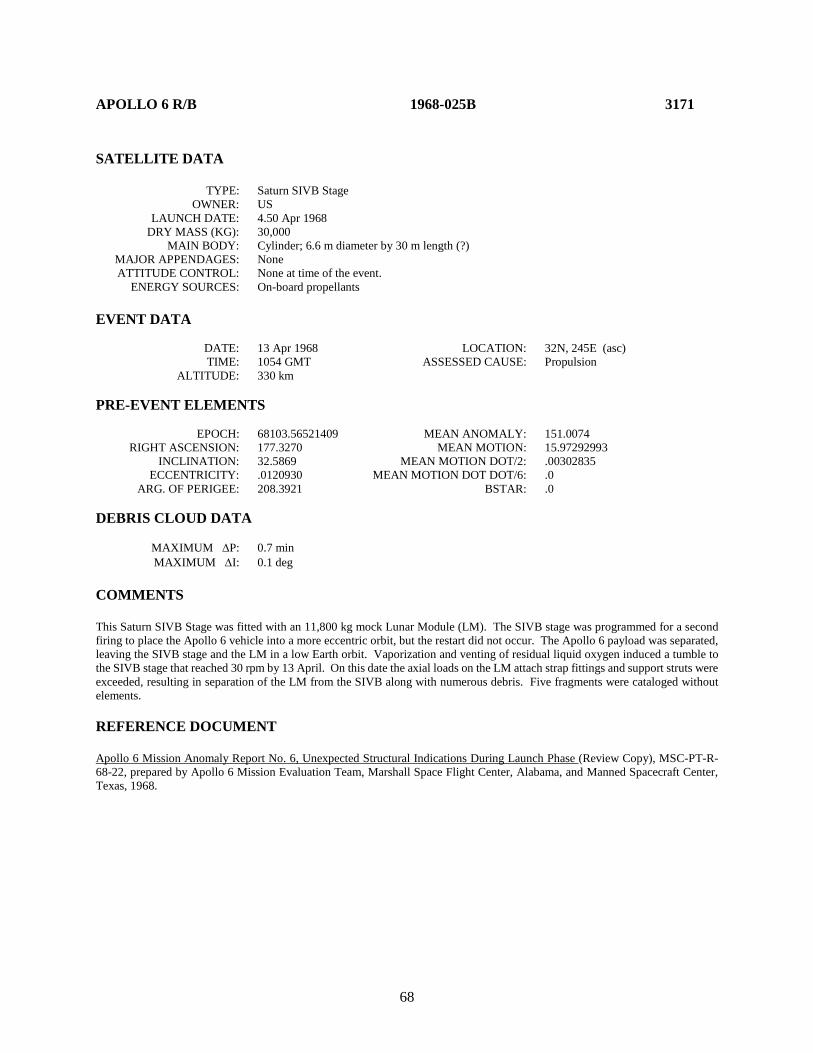
68
APOLLO 6 R/B 1968-025B 3171 SATELLITE DATA TYPE: Saturn SIVB Stage OWNER: US LAUNCH DATE: 4.50 Apr 1968 DRY MASS (KG): 30,000 MAIN BODY: Cylinder; 6.6 m diameter by 30 m length (?) MAJOR APPENDAGES: None ATTITUDE CONTROL: None at time of the event. ENERGY SOURCES: On-board propellants EVENT DATA DATE: 13 Apr 1968 LOCATION: 32N, 245E (asc) TIME: 1054 GMT ASSESSED CAUSE: Propulsion ALTITUDE: 330 km PRE-EVENT ELEMENTS EPOCH: 68103.56521409 MEAN ANOMALY: 151.0074 RIGHT ASCENSION: 177.3270 MEAN MOTION: 15.97292993 INCLINATION: 32.5869 MEAN MOTION DOT/2: .00302835 ECCENTRICITY: .0120930 MEAN MOTION DOT DOT/6: .0 ARG. OF PERIGEE: 208.3921 BSTAR: .0 DEBRIS CLOUD DATA MAXIMUM ∆P: 0.7 min MAXIMUM ∆I: 0.1 deg COMMENTS This Saturn SIVB Stage was fitted with an 11,800 kg mock Lunar Module (LM). The SIVB stage was programmed for a second firing to place the Apollo 6 vehicle into a more eccentric orbit, but the restart did not occur. The Apollo 6 payload was separated, leaving the SIVB stage and the LM in a low Earth orbit. Vaporization and venting of residual liquid oxygen induced a tumble to the SIVB stage that reached 30 rpm by 13 April. On this date the axial loads on the LM attach strap fittings and support struts were exceeded, resulting in separation of the LM from the SIVB along with numerous debris. Five fragments were cataloged without elements. REFERENCE DOCUMENT Apollo 6 Mission Anomaly Report No. 6, Unexpected Structural Indications During Launch Phase (Review Copy), MSC-PT-R-68-22, prepared by Apollo 6 Mission Evaluation Team, Marshall Space Flight Center, Alabama, and Manned Spacecraft Center, Texas, 1968.
69
Apollo 6 R/B debris cloud of 9 fragments 4 days after the event as reconstructed from the US SSN database.
0
100
200
300
400
500
600
89 90 91
Apog
ee/P
erig
ee A
ltitu
de (k
m)
Period (min)
Apogee
Perigee
SSN 3171
70
OV2-5 R/B 1968-081E 3432 SATELLITE DATA TYPE: Titan 3C Transtage OWNER: US LAUNCH DATE: 26.32 Sep 1968 DRY MASS (KG): 2500 MAIN BODY: Cylinder; 3 m diameter by 6 m length MAJOR APPENDAGES: None ATTITUDE CONTROL: Active, 3-axis ENERGY SOURCES: On-board propellants EVENT DATA DATE: 21 Feb 1992 LOCATION: Unknown (~ 197E) TIME: 0931 GMT ASSESSED CAUSE: Propulsion ALTITUDE: ~ 35600 PRE-EVENT ELEMENTS EPOCH: 92043.23217642 MEAN ANOMALY: 284.5600 RIGHT ASCENSION: 21.8025 MEAN MOTION: 1.01459126 INCLINATION: 11.9035 MEAN MOTION DOT/2: .00000174 ECCENTRICITY: .0084771 MEAN MOTION DOT DOT/6: .0 ARG. OF PERIGEE: 76.2786 BSTAR: .0 DEBRIS CLOUD DATA MAXIMUM ∆P: Unknown MAXIMUM ∆I: Unknown COMMENTS This was the second major fragmentation of a Titan 3C Transtage (the first was 1965-082DM). This transtage released ERS-28 (also known as OV5-2) in highly eccentric transfer orbit, then released LES-6 and ERS-21 (also known as OV5-4) in synchronous orbit, before slightly decelerating and releasing OV2-5 into a slightly lower orbit. This rocket body successfully completed its mission and remained on-orbit for 281 months before fragmenting. Mr. Bob Brock, operating the Maui GEODSS sensor, observed this transtage as it fragmented, liberating a reported 20 objects. REFERENCE DOCUMENTS TRW Space Log, Winter 1968-69 edition, Vol. 8, No. 4, H. T. Seaborn, ed., TRW Systems Group, Redondo Beach, pp. 32-35. “Debris in Geosynchronous Orbits”, A.F. Pensa et al, Space Forum, special issue, 1st International Workshop on Space Debris, Moscow, October 1995.
71
Insufficient data to construct a Gabbard diagram.

72
COSMOS 248 1968-090A 3503 SATELLITE DATA TYPE: Payload OWNER: CIS LAUNCH DATE: 19.18 Oct 1968 DRY MASS (KG): 1400 MAIN BODY: Irregular; 1.8 m by 4.2 m MAJOR APPENDAGES: Unknown ATTITUDE CONTROL: Active, 3-axis ENERGY SOURCES: On-board propellants EVENT DATA DATE: 1 Nov 1968 LOCATION: 55N, 104E (dsc) TIME: 0412 GMT ASSESSED CAUSE: Deliberate ALTITUDE: 540 km PRE-EVENT ELEMENTS EPOCH: 68304.83833772 MEAN ANOMALY: 61.1261 RIGHT ASCENSION: 82.2502 MEAN MOTION: 15.19330723 INCLINATION: 62.2495 MEAN MOTION DOT/2: .00016932 ECCENTRICITY: .0050333 MEAN MOTION DOT DOT/6: .0 ARG. OF PERIGEE: 298.4670 BSTAR: .0 DEBRIS CLOUD DATA MAXIMUM ∆P: Unknown MAXIMUM ∆I: 0.1 deg COMMENTS Cosmos 248 was the target of rendezvous for the Cosmos 249 and Cosmos 252 tests. Calculations suggest the few fragments detected from Cosmos 248 were released within 10 minutes of the Cosmos 252 event that took place in the vicinity of Cosmos 248. The four observed fragments were not cataloged until 4-6 weeks after the event, preventing an accurate assessment of the event due to drag effects. It is possible that the Cosmos 248 event occurred immediately after the rendezvous and was a direct result of interaction with Cosmos 252 debris. REFERENCE DOCUMENTS "Artificial Satellite Break-Ups (Part 2): Soviet Anti-Satellite Program", N.L. Johnson, Journal of the British Interplanetary Society, August 1983, pp. 357-362. History of Soviet/Russian Satellite Fragmentations-A Joint U.S.-Russian Investigation, N. L. Johnson et al, Kaman Sciences Corporation, October 1995.

73
Insufficient data to construct a Gabbard diagram.

74
COSMOS 249 1968-091A 3504 SATELLITE DATA TYPE: Payload OWNER: CIS LAUNCH DATE: 20.17 Oct 1968 DRY MASS (KG): 1400 MAIN BODY: Irregular; 1.8 m by 4.2 m MAJOR APPENDAGES: None ATTITUDE CONTROL: Active, 3-axis ENERGY SOURCES: On-board propellants, explosive charge EVENT DATA DATE: 20 Oct 1968 LOCATION: 57S, 181E (asc) TIME: 1427 GMT ASSESSED CAUSE: Deliberate ALTITUDE: 1995 km POST-EVENT ELEMENTS EPOCH: 68294.85197372 MEAN ANOMALY: 295.3555 RIGHT ASCENSION: 118.4255 MEAN MOTION: 12.83515528 INCLINATION: 62.3313 MEAN MOTION DOT/2: .0 ECCENTRICITY: .1088260 MEAN MOTION DOT DOT/6: .0 ARG. OF PERIGEE: 76.6147 BSTAR: .0 DEBRIS CLOUD DATA MAXIMUM ∆P: 3.9 min MAXIMUM ∆I: 0.4 deg COMMENTS Cosmos 249 was the first of a class of maneuverable spacecraft flown to rendezvous within 4 hours with another Cosmos satellite. In 9 of 20 such missions, orbital debris clouds were created by the active spacecraft, and in one case a passive (target) spacecraft also spawned a few fragments. Fragmentations occurred either in the vicinity of the passive satellite or a few hours after the rendezvous. In the case of Cosmos 249, the spacecraft was launched on a two-revolution rendezvous with Cosmos 248. After a close approach, Cosmos 249 continued on before its warhead was intentionally fired. The elements above are the first available for the final orbit. Some debris from Cosmos 249 and Cosmos 252 have been cross-tagged. REFERENCE DOCUMENTS "Artificial Satellite Break-Ups (Part 2): Soviet Anti-Satellite Program", N.L. Johnson, Journal of the British Interplanetary Society, August 1983, pp. 357-362. History of Soviet/Russian Satellite Fragmentations-A Joint U.S.-Russian Investigation, N. L. Johnson et al, Kaman Sciences Corporation, October 1995.
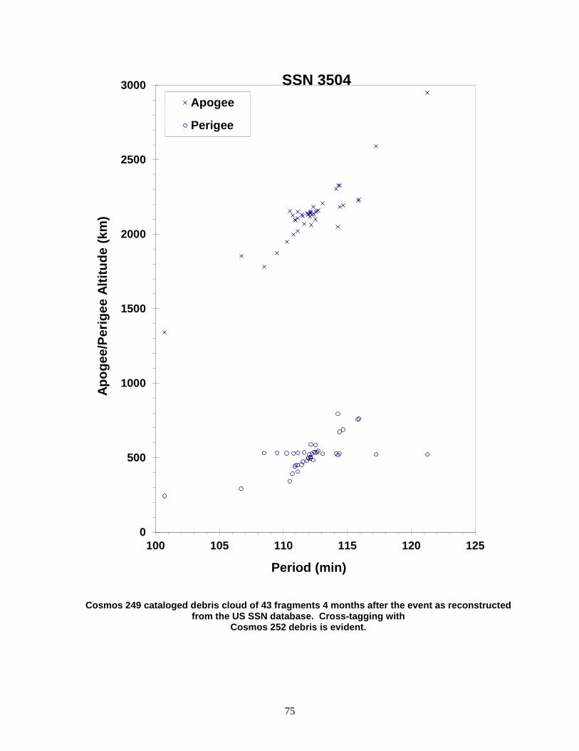
75
Cosmos 249 cataloged debris cloud of 43 fragments 4 months after the event as reconstructed from the US SSN database. Cross-tagging with
Cosmos 252 debris is evident.
0
500
1000
1500
2000
2500
3000
100 105 110 115 120 125
Apog
ee/P
erig
ee A
ltitu
de (k
m)
Period (min)
Apogee
Perigee
SSN 3504
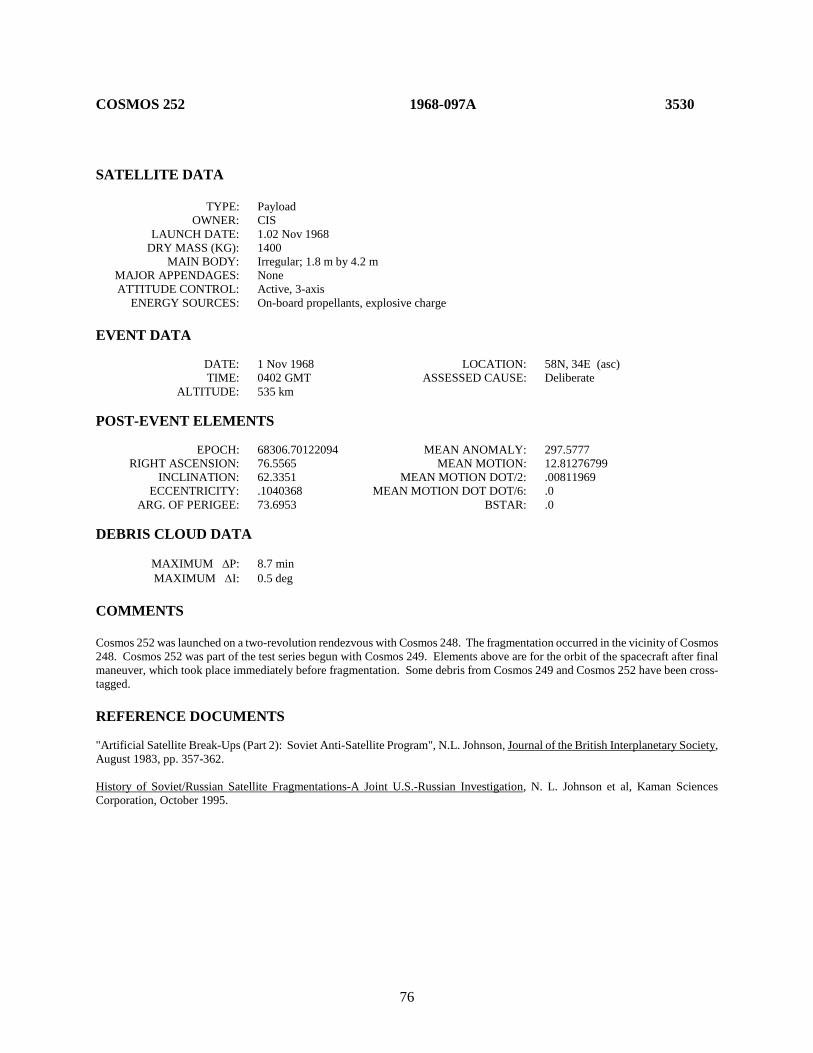
76
COSMOS 252 1968-097A 3530
SATELLITE DATA TYPE: Payload OWNER: CIS LAUNCH DATE: 1.02 Nov 1968 DRY MASS (KG): 1400 MAIN BODY: Irregular; 1.8 m by 4.2 m MAJOR APPENDAGES: None ATTITUDE CONTROL: Active, 3-axis ENERGY SOURCES: On-board propellants, explosive charge EVENT DATA DATE: 1 Nov 1968 LOCATION: 58N, 34E (asc) TIME: 0402 GMT ASSESSED CAUSE: Deliberate ALTITUDE: 535 km POST-EVENT ELEMENTS EPOCH: 68306.70122094 MEAN ANOMALY: 297.5777 RIGHT ASCENSION: 76.5565 MEAN MOTION: 12.81276799 INCLINATION: 62.3351 MEAN MOTION DOT/2: .00811969 ECCENTRICITY: .1040368 MEAN MOTION DOT DOT/6: .0 ARG. OF PERIGEE: 73.6953 BSTAR: .0 DEBRIS CLOUD DATA MAXIMUM ∆P: 8.7 min MAXIMUM ∆I: 0.5 deg COMMENTS Cosmos 252 was launched on a two-revolution rendezvous with Cosmos 248. The fragmentation occurred in the vicinity of Cosmos 248. Cosmos 252 was part of the test series begun with Cosmos 249. Elements above are for the orbit of the spacecraft after final maneuver, which took place immediately before fragmentation. Some debris from Cosmos 249 and Cosmos 252 have been cross-tagged. REFERENCE DOCUMENTS "Artificial Satellite Break-Ups (Part 2): Soviet Anti-Satellite Program", N.L. Johnson, Journal of the British Interplanetary Society, August 1983, pp. 357-362. History of Soviet/Russian Satellite Fragmentations-A Joint U.S.-Russian Investigation, N. L. Johnson et al, Kaman Sciences Corporation, October 1995.

77
Cosmos 252 cataloged debris cloud of 43 fragments 4 months after the event as reconstructed from the US SSN database. Cross-tagging with the
Cosmos 249 cloud is evident.
0
400
800
1200
1600
2000
2400
2800
99 104 109 114 119
Apog
ee/P
erig
ee A
ltitu
de (k
m)
Period (min)
Apogee
Perigee
SSN 3530

78
ESSA 8 (TOS F) R/B 1968-114B 3616 SATELLITE DATA TYPE: Delta 1 (model N) second stage Rocket Body OWNER: US LAUNCH DATE: 15.72 Dec 1968 DRY MASS (KG): 765 MAIN BODY: cylinder-nozzle; 1.4 m diameter x 4.8 m long right circular cylinder MAJOR APPENDAGES: none ATTITUDE CONTROL: none at time of event ENERGY SOURCES: on-board propellants; pressure vessels; chemical batteries EVENT DATA DATE: 15 Nov 1973 LOCATION: Unknown TIME: Unknown ASSESSED CAUSE: Propulsion ALTITUDE: Unknown PRE-EVENT ELEMENTS EPOCH: 73318.68417963 MEAN ANOMALY: 337.0891 RIGHT ASCENSION: 26.4043 MEAN MOTION: 12.56868935 INCLINATION: 101.6374 MEAN MOTION DOT/2: 0.00000260 ECCENTRICITY: 0.0031347 MEAN MOTION DOT DOT/6: 7.694E-8 ARG. OF PERIGEE: 23.1544 BSTAR: 0.00000 DEBRIS CLOUD DATA MAXIMUM ∆P: 5.7 min MAXIMUM ∆I: 0.8 deg COMMENTS The cause of this event, occurring approximately 4.9 years after launch, is assessed to be propulsion-related. This event is recognized, as of this edition, as the first breakup of a Delta 1 rocket body, predating the previously acknowledged first Delta event, the NOAA 3 R/B [q.v.], by approximately 43 days. REFERENCE DOCUMENT “First Delta Rocket Body Fragmentation Discovered”, The Orbital Debris Quarterly News, NASA JSC, August 2017. Available online at https://www.orbitaldebris.jsc.nasa.gov/quarterly-news/pdfs/odqnv21i3.pdf.

79
ESSA 8 R/B debris cloud of 17 fragments as reconstructed from the US SSN database.
These debris entered the public catalog approximately 43.4 years after the event.

80
TITAN IIIC TRANSTAGE R/B 1969-013B 3692 SATELLITE DATA TYPE: Transtage Rocket Body OWNER: US LAUNCH DATE: 9 Feb 1969 DRY MASS (KG): 1,874 MAIN BODY: 3.048 m diameter x ~5 m long right circular cylinder MAJOR APPENDAGES: none ATTITUDE CONTROL: inactive 3-axis ENERGY SOURCES: on-board propellants; pressure vessels; chemical batteries EVENT DATA DATE: 28 Feb 2018 LOCATION: 5.26S, 129.97E (asc) TIME: 2101 GMT ASSESSED CAUSE: Propulsion ALTITUDE: 37247.3 km PRE-EVENT ELEMENTS EPOCH: 18059.72033524 MEAN ANOMALY: 119.8108 RIGHT ASCENSION: 300.9448 MEAN MOTION: 0.97608930 INCLINATION: 6.2739 MEAN MOTION DOT/2: -0.00000274 ECCENTRICITY: 0.0164003 MEAN MOTION DOT DOT/6: 0.00000 ARG. OF PERIGEE: 128.1168 BSTAR: 0.00000 DEBRIS CLOUD DATA MAXIMUM ∆P: 134 min MAXIMUM ∆I: 0.9 deg COMMENTS The cause of this event, occurring approximately 49 years after launch, is likely due to on-board stored energy sources. This is the fourth breakup of a Titan Transtage rocket body, and the second Transtage fragmentation near geosynchronous orbit. Due to difficulties in cataloging highly elliptical and deep-space orbit many more fragments may be resident on-orbit than those cataloged. REFERENCE DOCUMENTS “Fragmentation of Titan Transtage in GEO”, The Orbital Debris Quarterly News, NASA JSC, May 2018. Available online at https://www.orbitaldebris.jsc.nasa.gov/quarterly-news/pdfs/odqnv22i2.pdf. Cowardin, H., P. Anz-Meador, and J. Reyes, “Characterizing GEO Titan IIIC Transtage Fragmentations using Ground-based and Telescopic Measurements”. In Proceedings of the AMOS 2017 Technical Conference. Available online at https://amostech.com/TechnicalPapers/2017/Orbital-Debris/Cowardin.pdf
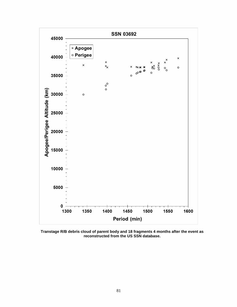
81
Transtage R/B debris cloud of parent body and 18 fragments 4 months after the event as reconstructed from the US SSN database.

82
METEOR 1-1 R/B 1969-029B 3836 SATELLITE DATA TYPE: Vostok Second Stage OWNER: CIS LAUNCH DATE: 26.52 Mar 1969 DRY MASS (KG): 1440 MAIN BODY: Cylinder; 2.6 m diameter by 3.8 m length MAJOR APPENDAGES: None ATTITUDE CONTROL: None at time of the event. ENERGY SOURCES: Unknown EVENT DATA DATE: 28 Mar 1969 LOCATION: 59N, 91E (dsc) TIME: 1845 GMT ASSESSED CAUSE: Unknown ALTITUDE: 555 km PRE-EVENT ELEMENTS EPOCH: 69087.21308063 MEAN ANOMALY: 175.1148 RIGHT ASCENSION: 33.3926 MEAN MOTION: 14.71400174 INCLINATION: 81.1687 MEAN MOTION DOT/2: .0 ECCENTRICITY: .0276787 MEAN MOTION DOT DOT/6: .0 ARG. OF PERIGEE: 184.7318 BSTAR: .0 DEBRIS CLOUD DATA MAXIMUM ∆P: 2.4 min MAXIMUM ∆I: 0.5 deg COMMENTS The vehicle successfully deployed the Meteor 1-1 payload into the desired orbit. An object believed to be the rocket body was found on 27 March in an orbit (1) of 565 km by 755 km, similar to earlier missions of the Vostok second stage. Early on 28 March an object was found in an orbit (2) of 460 km by 850 km with elements as indicated above. Analysis indicates that a transition from orbit (1) to orbit (2) was possible during the latter part of 27 March. Debris analysis clearly indicates that the orbit of the parent satellite had to be similar to orbit (2). Radar cross-section data supports the belief that the post-event object in the center of the debris cloud is the rocket body. No object was found in orbit (1) after the event. REFERENCE DOCUMENT History of the Soviet/Russian Satellite Fragmentations-A Joint U.S.-Russian Investigation, N. L. Johnson et al, Kaman Sciences Corporation, October 1995.
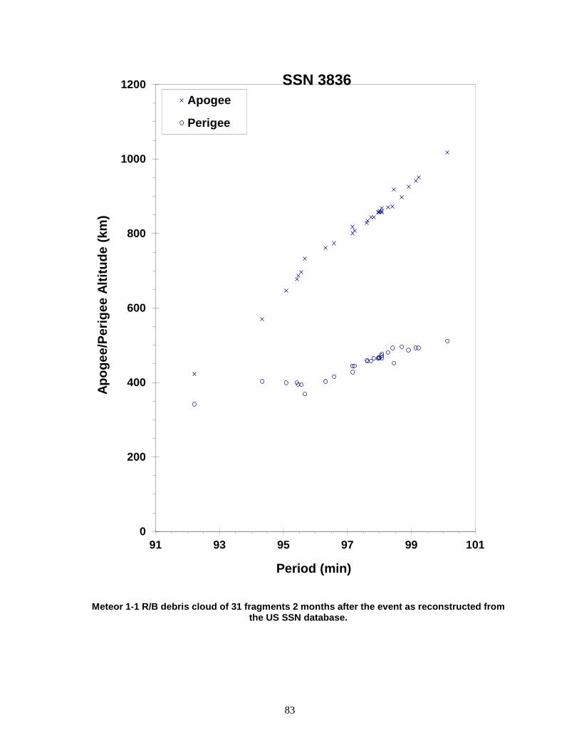
83
Meteor 1-1 R/B debris cloud of 31 fragments 2 months after the event as reconstructed from the US SSN database.
0
200
400
600
800
1000
1200
91 93 95 97 99 101
Apog
ee/P
erig
ee A
ltitu
de (k
m)
Period (min)
Apogee
Perigee
SSN 3836
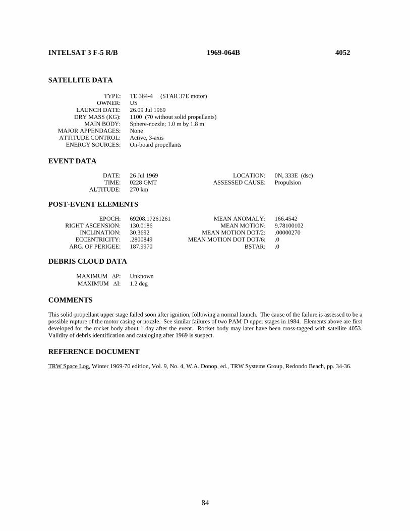
84
INTELSAT 3 F-5 R/B 1969-064B 4052 SATELLITE DATA TYPE: TE 364-4 (STAR 37E motor) OWNER: US LAUNCH DATE: 26.09 Jul 1969 DRY MASS (KG): 1100 (70 without solid propellants) MAIN BODY: Sphere-nozzle; 1.0 m by 1.8 m MAJOR APPENDAGES: None ATTITUDE CONTROL: Active, 3-axis ENERGY SOURCES: On-board propellants EVENT DATA DATE: 26 Jul 1969 LOCATION: 0N, 333E (dsc) TIME: 0228 GMT ASSESSED CAUSE: Propulsion ALTITUDE: 270 km POST-EVENT ELEMENTS EPOCH: 69208.17261261 MEAN ANOMALY: 166.4542 RIGHT ASCENSION: 130.0186 MEAN MOTION: 9.78100102 INCLINATION: 30.3692 MEAN MOTION DOT/2: .00000270 ECCENTRICITY: .2800849 MEAN MOTION DOT DOT/6: .0 ARG. OF PERIGEE: 187.9970 BSTAR: .0 DEBRIS CLOUD DATA MAXIMUM ∆P: Unknown MAXIMUM ∆I: 1.2 deg COMMENTS This solid-propellant upper stage failed soon after ignition, following a normal launch. The cause of the failure is assessed to be a possible rupture of the motor casing or nozzle. See similar failures of two PAM-D upper stages in 1984. Elements above are first developed for the rocket body about 1 day after the event. Rocket body may later have been cross-tagged with satellite 4053. Validity of debris identification and cataloging after 1969 is suspect. REFERENCE DOCUMENT TRW Space Log, Winter 1969-70 edition, Vol. 9, No. 4, W.A. Donop, ed., TRW Systems Group, Redondo Beach, pp. 34-36.
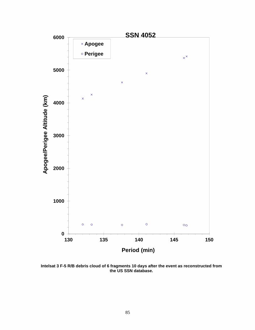
85
Intelsat 3 F-5 R/B debris cloud of 6 fragments 10 days after the event as reconstructed from the US SSN database.
0
1000
2000
3000
4000
5000
6000
130 135 140 145 150
Apog
ee/P
erig
ee A
ltitu
de (k
m)
Period (min)
Apogee
Perigee
SSN 4052

86
OPS 7613 R/B 1969-082AB 4159 SATELLITE DATA TYPE: Agena D Stage OWNER: US LAUNCH DATE: 30.57 Sep 1969 DRY MASS (KG): 600 MAIN BODY: Cylinder; 1.5 m diameter by 7.1 m length MAJOR APPENDAGES: None ATTITUDE CONTROL: None at time of the event. ENERGY SOURCES: Unknown EVENT DATA DATE: 4 Oct 1969 LOCATION: 54N, 178E (dsc) TIME: 1553 GMT ASSESSED CAUSE: Unknown ALTITUDE: 920 km POST-EVENT ELEMENTS EPOCH: 69295.54249482 MEAN ANOMALY: 274.0514 RIGHT ASCENSION: 243.5157 MEAN MOTION: 13.68701087 INCLINATION: 69.9611 MEAN MOTION DOT/2: .00000064 ECCENTRICITY: .0117819 MEAN MOTION DOT DOT/6: .0 ARG. OF PERIGEE: 87.4011 BSTAR: .0 DEBRIS CLOUD DATA MAXIMUM ∆P: 3.1 min MAXIMUM ∆I: 1.0 deg COMMENTS This was the first of two Agena D stages to fragment in a span of only 12 months. The vehicle delivered ten payloads to an orbit of about 905 km by 940 km. Four days later, before the rocket body had been cataloged, a large fragmentation occurred. What appeared to be the largest piece of the rocket body was found in the orbit described by the elements above almost 3 weeks after the event. See 1967-53 as a reference to an earlier mission of this type. Both missions were sponsored by DOD and public information is limited. REFERENCE DOCUMENT "Fragmentations of Asteroids and Artificial Satellites in Orbit", W. Wiesel, Icarus, Vol. 34, 1978, pp. 99-116.
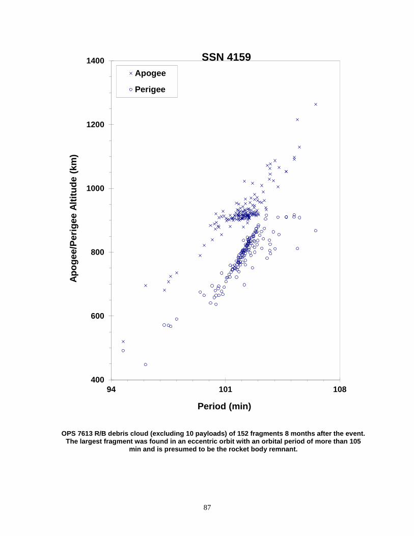
87
OPS 7613 R/B debris cloud (excluding 10 payloads) of 152 fragments 8 months after the event. The largest fragment was found in an eccentric orbit with an orbital period of more than 105
min and is presumed to be the rocket body remnant.
400
600
800
1000
1200
1400
94 101 108
Apog
ee/P
erig
ee A
ltitu
de (k
m)
Period (min)
Apogee
Perigee
SSN 4159
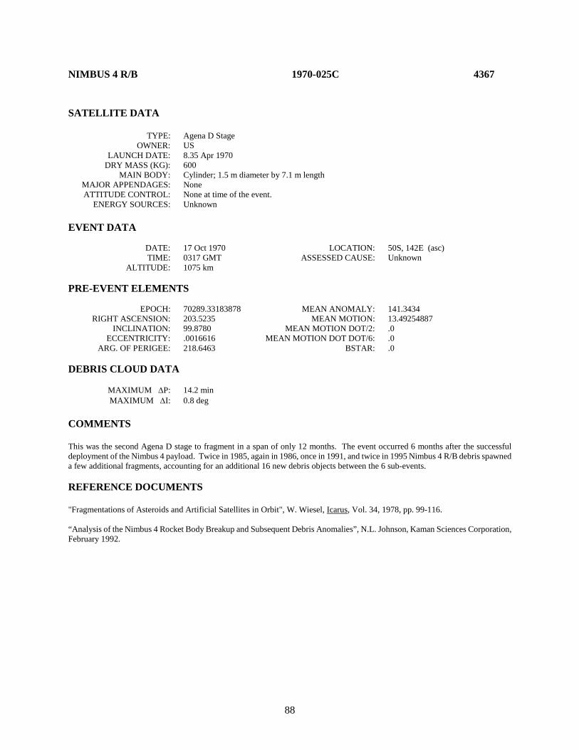
88
NIMBUS 4 R/B 1970-025C 4367 SATELLITE DATA TYPE: Agena D Stage OWNER: US LAUNCH DATE: 8.35 Apr 1970 DRY MASS (KG): 600 MAIN BODY: Cylinder; 1.5 m diameter by 7.1 m length MAJOR APPENDAGES: None ATTITUDE CONTROL: None at time of the event. ENERGY SOURCES: Unknown EVENT DATA DATE: 17 Oct 1970 LOCATION: 50S, 142E (asc) TIME: 0317 GMT ASSESSED CAUSE: Unknown ALTITUDE: 1075 km PRE-EVENT ELEMENTS EPOCH: 70289.33183878 MEAN ANOMALY: 141.3434 RIGHT ASCENSION: 203.5235 MEAN MOTION: 13.49254887 INCLINATION: 99.8780 MEAN MOTION DOT/2: .0 ECCENTRICITY: .0016616 MEAN MOTION DOT DOT/6: .0 ARG. OF PERIGEE: 218.6463 BSTAR: .0 DEBRIS CLOUD DATA MAXIMUM ∆P: 14.2 min MAXIMUM ∆I: 0.8 deg COMMENTS This was the second Agena D stage to fragment in a span of only 12 months. The event occurred 6 months after the successful deployment of the Nimbus 4 payload. Twice in 1985, again in 1986, once in 1991, and twice in 1995 Nimbus 4 R/B debris spawned a few additional fragments, accounting for an additional 16 new debris objects between the 6 sub-events. REFERENCE DOCUMENTS "Fragmentations of Asteroids and Artificial Satellites in Orbit", W. Wiesel, Icarus, Vol. 34, 1978, pp. 99-116. “Analysis of the Nimbus 4 Rocket Body Breakup and Subsequent Debris Anomalies”, N.L. Johnson, Kaman Sciences Corporation, February 1992.

89
Nimbus 4 R/B debris cloud of 246 fragments 8 months after the event as reconstructed from the US SSN database. Some lower period fragments already exhibit the
effects of natural decay.
0
400
800
1200
1600
2000
2400
90 95 100 105 110 115 120 125
Apog
ee/P
erig
ee A
ltitu
de (k
m)
Period (min)
Apogee
Perigee
SSN 4367
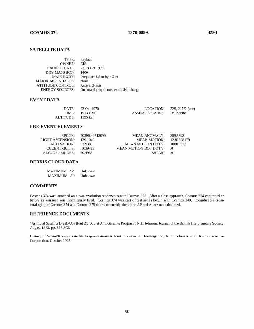
90
COSMOS 374 1970-089A 4594 SATELLITE DATA TYPE: Payload OWNER: CIS LAUNCH DATE: 23.18 Oct 1970 DRY MASS (KG): 1400 MAIN BODY: Irregular; 1.8 m by 4.2 m MAJOR APPENDAGES: None ATTITUDE CONTROL: Active, 3-axis ENERGY SOURCES: On-board propellants, explosive charge EVENT DATA DATE: 23 Oct 1970 LOCATION: 22S, 217E (asc) TIME: 1513 GMT ASSESSED CAUSE: Deliberate ALTITUDE: 1195 km PRE-EVENT ELEMENTS EPOCH: 70296.40542099 MEAN ANOMALY: 309.5623 RIGHT ASCENSION: 129.1049 MEAN MOTION: 12.82808179 INCLINATION: 62.9380 MEAN MOTION DOT/2: .00019973 ECCENTRICITY: .1039489 MEAN MOTION DOT DOT/6: .0 ARG. OF PERIGEE: 60.4933 BSTAR: .0 DEBRIS CLOUD DATA MAXIMUM ∆P: Unknown MAXIMUM ∆I: Unknown COMMENTS Cosmos 374 was launched on a two-revolution rendezvous with Cosmos 373. After a close approach, Cosmos 374 continued on before its warhead was intentionally fired. Cosmos 374 was part of test series begun with Cosmos 249. Considerable cross-cataloging of Cosmos 374 and Cosmos 375 debris occurred; therefore, ∆P and ∆I are not calculated. REFERENCE DOCUMENTS "Artificial Satellite Break-Ups (Part 2): Soviet Anti-Satellite Program", N.L. Johnson, Journal of the British Interplanetary Society, August 1983, pp. 357-362. History of Soviet/Russian Satellite Fragmentations-A Joint U.S.-Russian Investigation, N. L. Johnson et al, Kaman Sciences Corporation, October 1995.
91
Cosmos 374 official debris cloud of 43 fragments 5 months after the event as reconstructed from the US SSN database. All fragments were cataloged after
the Cosmos 375 fragmentation, and some contamination exists.
0
400
800
1200
1600
2000
2400
2800
3200
105 110 115 120 125
Apog
ee/P
erig
ee A
ltitu
de (k
m)
Period (min)
Apogee
Perigee
SSN 4594

92
COSMOS 375 1970-091A 4598 SATELLITE DATA TYPE: Payload OWNER: CIS LAUNCH DATE: 30.09 Oct 1970 DRY MASS (KG): 1400 MAIN BODY: Irregular; 1.8 m by 4.2 m MAJOR APPENDAGES: None ATTITUDE CONTROL: Active, 3-axis ENERGY SOURCES: On-board propellants, explosive charge EVENT DATA DATE: 30 Oct 1970 LOCATION: 54N, 23E (asc) TIME: 0600 GMT ASSESSED CAUSE: Deliberate ALTITUDE: 535 km POST-EVENT ELEMENTS EPOCH: 70306.81102869 MEAN ANOMALY: 313.3102 RIGHT ASCENSION: 96.4080 MEAN MOTION: 12.87482205 INCLINATION: 62.8057 MEAN MOTION DOT/2: .00009999 ECCENTRICITY: .1022289 MEAN MOTION DOT DOT/6: .0 ARG. OF PERIGEE: 56.0864 BSTAR: .0 DEBRIS CLOUD DATA MAXIMUM ∆P: Unknown MAXIMUM ∆I: Unknown COMMENTS Cosmos 375 was launched on a two-revolution rendezvous with Cosmos 373. The fragmentation occurred in the vicinity of Cosmos 373. Cosmos 375 was part of test series begun with Cosmos 249. Elements above are first reliable ones for orbit after final maneuver that took place immediately before fragmentation. Considerable cross-cataloging of Cosmos 374 and Cosmos 375 debris occurred; therefore, ∆P and ∆I are not calculated. REFERENCE DOCUMENTS "Artificial Satellite Break-Ups (Part 2): Soviet Anti-Satellite Program", N.L. Johnson, Journal of the British Interplanetary Society, August 1983, pp. 357-362. History of Soviet/Russian Satellite Fragmentations-A Joint U.S.-Russian Investigation, N. L. Johnson et al, Kaman Sciences Corporation, October 1995.
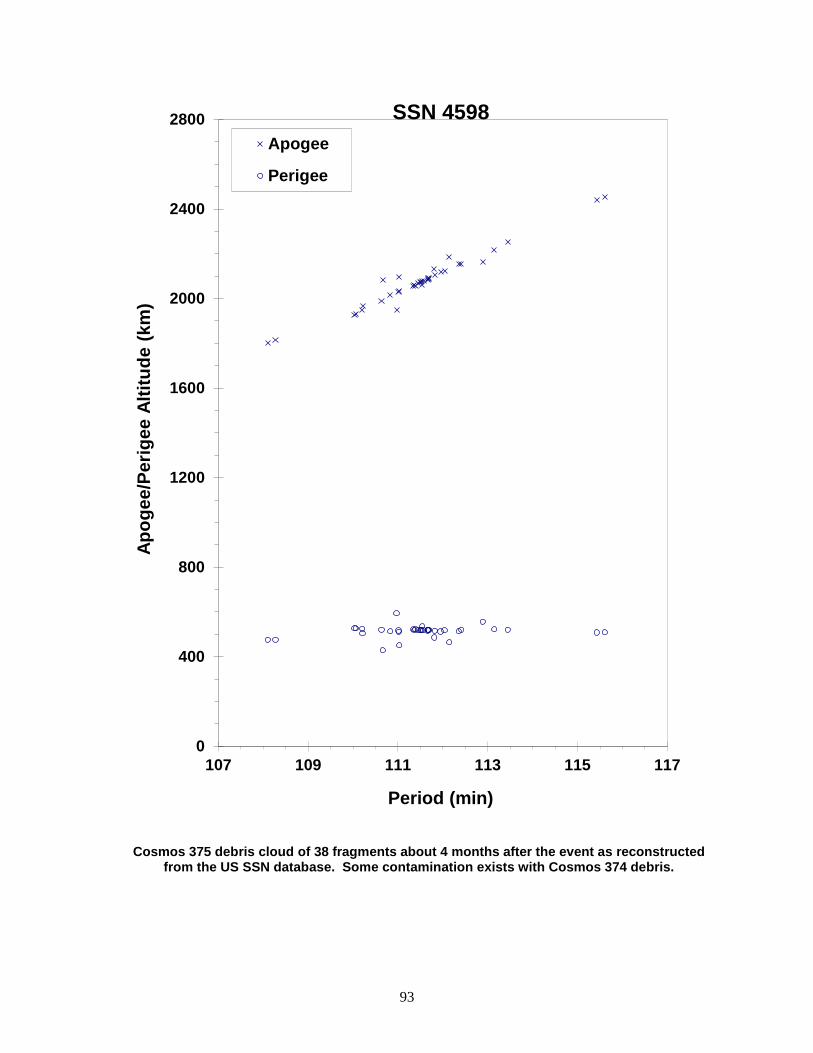
93
Cosmos 375 debris cloud of 38 fragments about 4 months after the event as reconstructed from the US SSN database. Some contamination exists with Cosmos 374 debris.
0
400
800
1200
1600
2000
2400
2800
107 109 111 113 115 117
Apog
ee/P
erig
ee A
ltitu
de (k
m)
Period (min)
Apogee
Perigee
SSN 4598

94
COSMOS 397 1971-015A 4964 SATELLITE DATA TYPE: Payload OWNER: CIS LAUNCH DATE: 25.47 Feb 1971 DRY MASS (KG): 1400 MAIN BODY: Irregular; 1.8 m by 4.2 m MAJOR APPENDAGES: None ATTITUDE CONTROL: Active, 3-axis ENERGY SOURCES: On-board propellants, explosive charge EVENT DATA DATE: 25 Feb 1971 LOCATION: 54N, 21E (asc) TIME: 1431 GMT ASSESSED CAUSE: Deliberate ALTITUDE: 585 km POST-EVENT ELEMENTS EPOCH: 71057.77590281 MEAN ANOMALY: 318.5528 RIGHT ASCENSION: 352.8670 MEAN MOTION: 12.68709606 INCLINATION: 65.7618 MEAN MOTION DOT/2: .00013192 ECCENTRICITY: .1046189 MEAN MOTION DOT DOT/6: .0 ARG. OF PERIGEE: 50.3064 BSTAR: .0 DEBRIS CLOUD DATA MAXIMUM ∆P: 2.8 min MAXIMUM ∆I: 1.2 deg COMMENTS Cosmos 397 was launched on a two-revolution rendezvous with Cosmos 394. The fragmentation occurred in the vicinity of Cosmos 394. Cosmos 397 was part of the test series begun with Cosmos 249. Elements above are first available for orbit after final maneuver that took place immediately before fragmentation. REFERENCE DOCUMENTS "Artificial Satellite Break-Ups (Part 2): Soviet Anti-Satellite Program", N.L. Johnson, Journal of the British Interplanetary Society, August 1983, pp. 357-362. History of Soviet/Russian Satellite Fragmentations-A Joint U.S.-Russian Investigation, N. L. Johnson et al, Kaman Sciences Corporation, October 1995.

95
Cosmos 397 cataloged debris cloud of 26 fragments about 7 weeks after the event as reconstructed from the US SSN database.
0
400
800
1200
1600
2000
2400
2800
110 111 112 113 114 115 116
Apog
ee/P
erig
ee A
ltitu
de (k
m)
Period (min)
Apogee
Perigee
SSN 4964
96
COSMOS 462 1971-106A 5646 SATELLITE DATA TYPE: Payload OWNER: CIS LAUNCH DATE: 3.55 Dec 1971 DRY MASS (KG): 1400 MAIN BODY: Irregular; 1.8 m by 4.2 m MAJOR APPENDAGES: None ATTITUDE CONTROL: Active, 3-axis ENERGY SOURCES: On-board propellants, explosive charge EVENT DATA DATE: 3 Dec 1971 LOCATION: 51N, 7E (asc) TIME: 1651 GMT ASSESSED CAUSE: Deliberate ALTITUDE: 230 km POST-EVENT ELEMENTS EPOCH: 71339.01001769 MEAN ANOMALY: 316.0762 RIGHT ASCENSION: 294.0999 MEAN MOTION: 13.65823046 INCLINATION: 65.7483 MEAN MOTION DOT/2: .00001349 ECCENTRICITY: .1062360 MEAN MOTION DOT DOT/6: .0 ARG. OF PERIGEE: 53.3215 BSTAR: .0 DEBRIS CLOUD DATA MAXIMUM ∆P: 3.6 min MAXIMUM ∆I: 0.7 deg COMMENTS Cosmos 462 was launched on a two-revolution rendezvous with Cosmos 459. The fragmentation occurred in the vicinity of Cosmos 459. Cosmos 462 was part of test series begun with Cosmos 249. Elements above are first available for orbit after final maneuver that took place immediately before fragmentation. REFERENCE DOCUMENTS "Artificial Satellite Break-Ups (Part 2): Soviet Anti-Satellite Program", N.L. Johnson, Journal of the British Interplanetary Society, August 1983, pp. 357-362. History of Soviet/Russian Satellite Fragmentations-A Joint U.S.-Russian Investigation, N. L. Johnson et al, Kaman Sciences Corporation, October 1995.

97
Cosmos 462 debris cloud of 25 cataloged fragments within 1 week of the event as reconstructed from the US SSN database.
0
400
800
1200
1600
2000
2400
90 95 100 105 110
Apog
ee/P
erig
ee A
ltitu
de (k
m)
Period (min)
Apogee
Perigee
SSN 5646
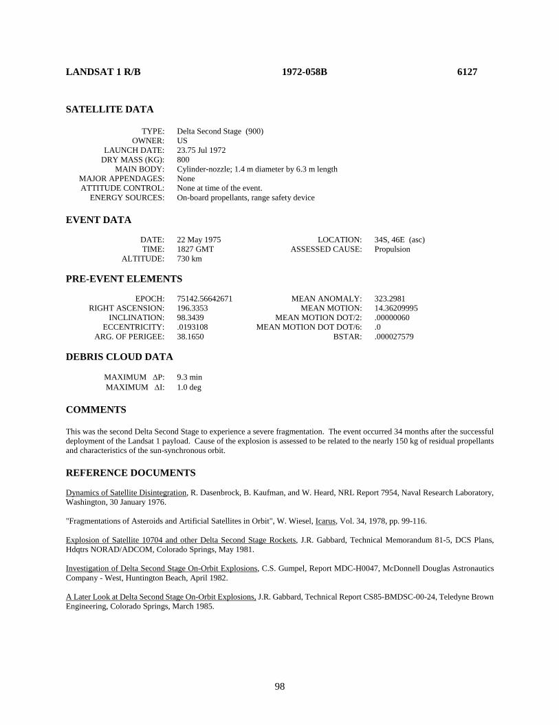
98
LANDSAT 1 R/B 1972-058B 6127 SATELLITE DATA TYPE: Delta Second Stage (900) OWNER: US LAUNCH DATE: 23.75 Jul 1972 DRY MASS (KG): 800 MAIN BODY: Cylinder-nozzle; 1.4 m diameter by 6.3 m length MAJOR APPENDAGES: None ATTITUDE CONTROL: None at time of the event. ENERGY SOURCES: On-board propellants, range safety device EVENT DATA DATE: 22 May 1975 LOCATION: 34S, 46E (asc) TIME: 1827 GMT ASSESSED CAUSE: Propulsion ALTITUDE: 730 km PRE-EVENT ELEMENTS EPOCH: 75142.56642671 MEAN ANOMALY: 323.2981 RIGHT ASCENSION: 196.3353 MEAN MOTION: 14.36209995 INCLINATION: 98.3439 MEAN MOTION DOT/2: .00000060 ECCENTRICITY: .0193108 MEAN MOTION DOT DOT/6: .0 ARG. OF PERIGEE: 38.1650 BSTAR: .000027579 DEBRIS CLOUD DATA MAXIMUM ∆P: 9.3 min MAXIMUM ∆I: 1.0 deg COMMENTS This was the second Delta Second Stage to experience a severe fragmentation. The event occurred 34 months after the successful deployment of the Landsat 1 payload. Cause of the explosion is assessed to be related to the nearly 150 kg of residual propellants and characteristics of the sun-synchronous orbit. REFERENCE DOCUMENTS Dynamics of Satellite Disintegration, R. Dasenbrock, B. Kaufman, and W. Heard, NRL Report 7954, Naval Research Laboratory, Washington, 30 January 1976. "Fragmentations of Asteroids and Artificial Satellites in Orbit", W. Wiesel, Icarus, Vol. 34, 1978, pp. 99-116. Explosion of Satellite 10704 and other Delta Second Stage Rockets, J.R. Gabbard, Technical Memorandum 81-5, DCS Plans, Hdqtrs NORAD/ADCOM, Colorado Springs, May 1981. Investigation of Delta Second Stage On-Orbit Explosions, C.S. Gumpel, Report MDC-H0047, McDonnell Douglas Astronautics Company - West, Huntington Beach, April 1982. A Later Look at Delta Second Stage On-Orbit Explosions, J.R. Gabbard, Technical Report CS85-BMDSC-00-24, Teledyne Brown Engineering, Colorado Springs, March 1985.
99
Landsat 1 R/B debris cloud of 133 fragments 4 months after the event as reconstructed from the US SSN database.
0
400
800
1200
1600
2000
90 95 100 105 110
Apog
ee/P
erig
ee A
ltitu
de (k
m)
Period (min)
Apogee
Perigee
SSN 6127
100
SALYUT 2 R/B 1973-017B 6399 SATELLITE DATA TYPE: Proton Third Stage OWNER: CIS LAUNCH DATE: 3.38 Apr 1973 DRY MASS (KG): 4000 MAIN BODY: Cylinder; 4.0 m diameter by 12.0 m length MAJOR APPENDAGES: None ATTITUDE CONTROL: None at time of the event. ENERGY SOURCES: On-board propellants EVENT DATA DATE: 3 Apr 1973 LOCATION: 45N, 290E (dsc) TIME: 2236 GMT ASSESSED CAUSE: Propulsion ALTITUDE: 225 km PRE-EVENT ELEMENTS EPOCH: 73093.61404736 MEAN ANOMALY: 357.9254 RIGHT ASCENSION: 334.5652 MEAN MOTION: 16.20127597 INCLINATION: 51.4798 MEAN MOTION DOT/2: .00508885 ECCENTRICITY: .0037670 MEAN MOTION DOT DOT/6: .0 ARG. OF PERIGEE: 2.1878 BSTAR: .0 DEBRIS CLOUD DATA MAXIMUM ∆P: 3.8 min MAXIMUM ∆I: 0.5 deg COMMENTS This is the only known fragmentation of the Proton third stage. The event occurred less than 14 hours after reaching orbit. The event was apparently unrelated to the later payload malfunction. NAVSPASUR counted at least 95 objects shortly after the event, but most reentered before being officially cataloged. Information uncovered by Mr. Nicholas Johnson during an information exchange with Russian officials in the Spring of 1993 revealed that residual propellants resulted in an over-pressurization of the rocket body, causing this fragmentation. After this event, the Russians reported that the Proton third stage has been vented to avoid future events of this nature.

101
Salyut 2 R/B debris cloud of 25 fragments as reconstructed from the US SSN database. Most elements were developed within 2 days of the event.
100
200
300
400
500
600
700
88 89 90 91 92 93
Apog
ee/P
erig
ee A
ltitu
de (k
m)
Period (min)
Apogee
Perigee
SSN 6399
102
COSMOS 554 1973-021A 6432 SATELLITE DATA TYPE: Payload OWNER: CIS LAUNCH DATE: 19.38 Apr 1973 DRY MASS (KG): 6300 MAIN BODY: Sphere-cylinder; 2.8 m diameter by 6.5 m length MAJOR APPENDAGES: None ATTITUDE CONTROL: Active, 3-axis ENERGY SOURCES: On-board propellants, explosive charge EVENT DATA DATE: 6 May 1973 LOCATION: 71S, 215E (asc) TIME: 0724 GMT ASSESSED CAUSE: Deliberate ALTITUDE: 310 km PRE-EVENT ELEMENTS EPOCH: 73125.63953480 MEAN ANOMALY: 337.7411 RIGHT ASCENSION: 305.5573 MEAN MOTION: 16.05578988 INCLINATION: 72.8514 MEAN MOTION DOT/2: .00433078 ECCENTRICITY: .0137599 MEAN MOTION DOT DOT/6: .00010923 ARG. OF PERIGEE: 22.9846 BSTAR: .0 DEBRIS CLOUD DATA MAXIMUM ∆P: 6.0 min MAXIMUM ∆I: 1.3 deg COMMENTS Spacecraft was destroyed after a malfunction prevented controlled reentry and landing in the Soviet Union. A total of 88 fragments were cataloged without elements. REFERENCE DOCUMENT History of Soviet/Russian Satellite Fragmentations-A Joint U.S.-Russian Investigation, N. L. Johnson et al, Kaman Sciences Corporation, October 1995.
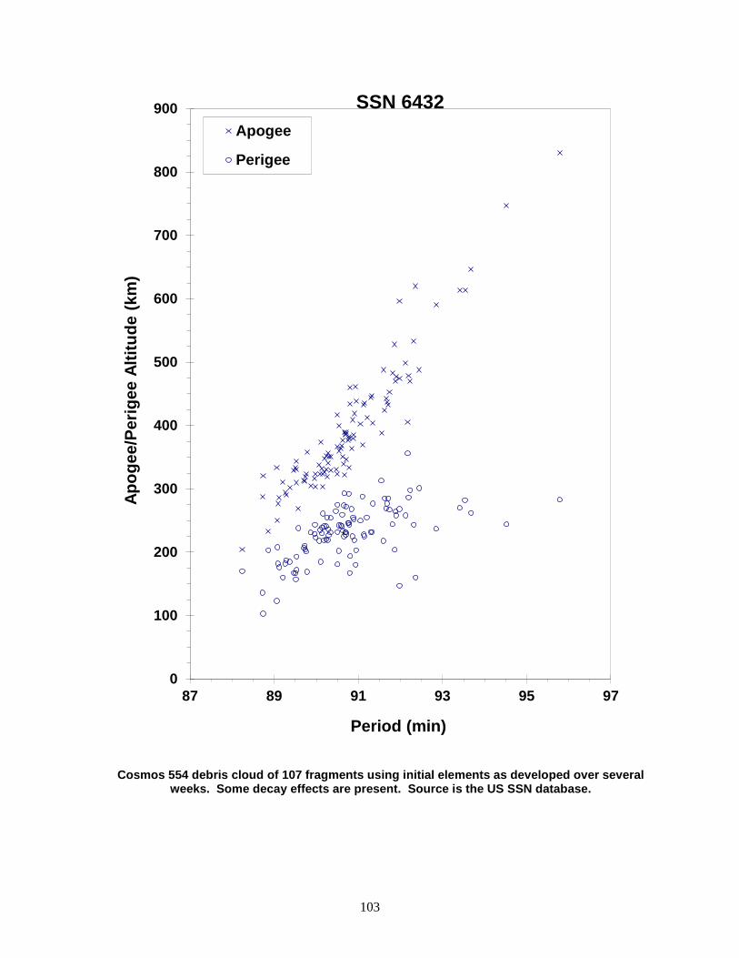
103
Cosmos 554 debris cloud of 107 fragments using initial elements as developed over several weeks. Some decay effects are present. Source is the US SSN database.
0
100
200
300
400
500
600
700
800
900
87 89 91 93 95 97
Apog
ee/P
erig
ee A
ltitu
de (k
m)
Period (min)
Apogee
Perigee
SSN 6432
104
NOAA 3 R/B 1973-086B 6921 SATELLITE DATA TYPE: Delta Second Stage (300) OWNER: US LAUNCH DATE: 6.71 Nov 1973 DRY MASS (KG): 840 MAIN BODY: Cylinder-nozzle; 1.4 m diameter by 6.3 m length MAJOR APPENDAGES: None ATTITUDE CONTROL: None at time of the event. ENERGY SOURCES: On-board propellants, range safety device EVENT DATA DATE: 28 Dec 1973 LOCATION: 37S, 181E (asc) TIME: 0904 GMT ASSESSED CAUSE: Propulsion ALTITUDE: 1515 km PRE-EVENT ELEMENTS EPOCH: 73359.56303028 MEAN ANOMALY: 202.2816 RIGHT ASCENSION: 41.7242 MEAN MOTION: 12.40088347 INCLINATION: 102.0500 MEAN MOTION DOT/2: .00000577 ECCENTRICITY: .0005689 MEAN MOTION DOT DOT/6: .000000056523 ARG. OF PERIGEE: 157.8450 BSTAR: .0 DEBRIS CLOUD DATA MAXIMUM ∆P: 10.4 min MAXIMUM ∆I: 1.4 deg COMMENTS This was the first of seven Delta Second Stages to experience severe fragmentations between 1973 and 1981. Six of the seven stages were left in mid-morning, sun-synchronous orbits with residual propellants. Fragmentations occurred from 2-35 months after launch. The seventh stage exploded within hours of launch on a geosynchronous mission. The assessed cause in all cases is a propellant-induced explosion. Depletion burns to remove residual propellants were initiated in 1981, and no vented Delta Second Stages have fragmented since. In the case of the NOAA 3 R/B, fragmentation took place nearly 2 months after successful deployment of the NOAA 3 payload. Approximately 130 kg of propellants were left on board. REFERENCE DOCUMENTS Dynamics of Satellite Disintegration, R. Dasenbrock, B. Kaufman, and W. Heard, NRL Report 7954, Naval Research Laboratory, Washington, 30 January 1976. Explosion of Satellite 10704 and other Delta Second Stage Rockets, J.R. Gabbard, Technical Memorandum 81-5, DCS Plans, Hdqtrs NORAD/ADCOM, Colorado Springs, May 1981. Investigation of Delta Second Stage On-Orbit Explosions, C.S. Gumpel, Report MDC-H0047, McDonnell Douglas Astronautics Company - West, Huntington Beach, April 1982. A Later Look at Delta Second Stage On-Orbit Explosions, J.R. Gabbard, Technical Report CS85-BMDSC-00-24, Teledyne Brown Engineering, Colorado Springs, March 1985.

105
NOAA 3 R/B debris cloud of 160 fragments 4 months after the event as reconstructed from the US SSN database.
200
600
1000
1400
1800
2200
2600
100 110 120 130
Apog
ee/P
erig
ee A
ltitu
de (k
m)
Period (min)
Apogee
Perigee
SSN 6921

106
DMSP 5B F5 R/B 1974-015B 7219 SATELLITE DATA TYPE: Rocket Body OWNER: US LAUNCH DATE: 16.33 Mar 1974 DRY MASS (KG): 50 MAIN BODY: Box; 1 m long by 1 m wide by 1 m high MAJOR APPENDAGES: None ATTITUDE CONTROL: None at time of event ENERGY SOURCES: None at time of event EVENT DATA DATE: 17 Jan 2005 LOCATION: 80.6S, 306.8E TIME: 0214 GMT ASSESSED CAUSE: Accidental Collision ALTITUDE: 885 km PRE-EVENT ELEMENTS EPOCH: 05016.54972523 MEAN ANOMALY: 256.1717 RIGHT ASCENSION: 350.2846 MEAN MOTION: 14.24162249 INCLINATION: 99.0928 MEAN MOTION DOT/2: 0.00000028 ECCENTRICITY: .0066248 MEAN MOTION DOT DOT/6: 0.0 ARG. OF PERIGEE: 104.6813 BSTAR: 0.000031607 DEBRIS CLOUD DATA MAXIMUM ∆P: Unknown MAXIMUM ∆I: Unknown COMMENTS The THOR 2A upper stage collided with a piece of fragmentation debris (1999-57CV, SSN# 26207) from the March 2000 explosion of the third stage of a Chinese CZ-4 launch vehicle (1999-57C, SSN# 25942). This was the third historical collision of cataloged objects; the collision occurred over Antarctica as both object were near the southernmost point in their respective retrograde orbits. The relative velocity of the collision was just under 6 km/s. 1999-57CV is believed to be relatively small, with a radar cross-section of 600 cm2. The collision produced less than 10 cataloged debris. Because the upper stage had been in orbit for over 30 years, it is believed there was no on-board propellant remaining at the time of the event. REFERENCE DOCUMENT “Accidental Collisions of Cataloged Satellites Identified”, The Orbital Debris Quarterly News, NASA JSC, April 2005. Available online at https://orbitaldebris.jsc.nasa.gov/quarterly-news/pdfs/ODQNv9i2.pdf.

107
Insufficient data to construct a Gabbard diagram.
108
NOAA 4 R/B 1974-089D 7532 SATELLITE DATA TYPE: Delta Second Stage (2310) OWNER: US LAUNCH DATE: 15.72 Nov 1974 DRY MASS (KG): 840 MAIN BODY: Cylinder-nozzle; 1.4 m diameter by 5.8 m length MAJOR APPENDAGES: Mini-skirt; 2.4m by 0.3 m ATTITUDE CONTROL: None at time of the event. ENERGY SOURCES: On-board propellants, range safety device EVENT DATA DATE: 20 Aug 1975 LOCATION: 52S, 278E (dsc) TIME: 1307 GMT ASSESSED CAUSE: Propulsion ALTITUDE: 1465 km PRE-EVENT ELEMENTS EPOCH: 75231.53619619 MEAN ANOMALY: 309.0001 RIGHT ASCENSION: 277.2201 MEAN MOTION: 12.52826370 INCLINATION: 101.6940 MEAN MOTION DOT/2: .00000083 ECCENTRICITY: .0009694 MEAN MOTION DOT DOT/6: .0 ARG. OF PERIGEE: 51.1891 BSTAR: .0 DEBRIS CLOUD DATA MAXIMUM ∆P: 15.7 min MAXIMUM ∆I: 1.8 deg COMMENTS This was the third Delta Second Stage to experience a severe fragmentation. The event occurred 9 months after the successful deployment of the NOAA 4 payload. Cause of the explosion is assessed to be related to the estimated more than 200 kg of residual propellants and characteristics of the sun-synchronous orbit. A fragment from this event (satellite number 8138) may have generated six or more additional pieces in September 1981. REFERENCE DOCUMENTS Explosion of Satellite 10704 and other Delta Second Stage Rockets, J.R. Gabbard, Technical Memorandum 81-5, DCS Plans, Hdqtrs NORAD/ADCOM, Colorado Springs, May 1981. Investigation of Delta Second Stage On-Orbit Explosions, C.S. Gumpel, Report MDC-H0047, McDonnell Douglas Astronautics Company - West, Huntington Beach, April 1982. A Later Look at Delta Second Stage On-Orbit Explosions, J.R. Gabbard, Technical Report CS85-BMDSC-00-24, Teledyne Brown Engineering, Colorado Springs, March 1985.
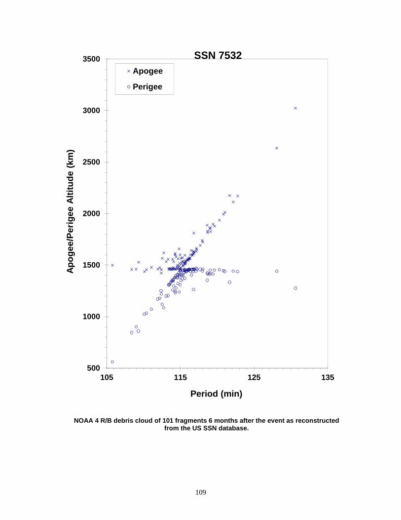
109
NOAA 4 R/B debris cloud of 101 fragments 6 months after the event as reconstructed from the US SSN database.
500
1000
1500
2000
2500
3000
3500
105 115 125 135
Apog
ee/P
erig
ee A
ltitu
de (k
m)
Period (min)
Apogee
Perigee
SSN 7532
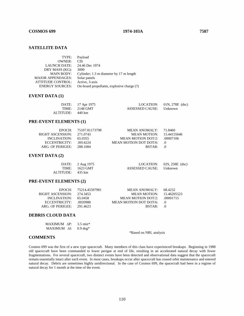
110
COSMOS 699 1974-103A 7587 SATELLITE DATA TYPE: Payload OWNER: CIS LAUNCH DATE: 24.46 Dec 1974 DRY MASS (KG): 3000 MAIN BODY: Cylinder; 1.3 m diameter by 17 m length MAJOR APPENDAGES: Solar panels ATTITUDE CONTROL: Active, 3-axis ENERGY SOURCES: On-board propellants, explosive charge (?) EVENT DATA (1) DATE: 17 Apr 1975 LOCATION: 01N, 278E (dsc) TIME: 2148 GMT ASSESSED CAUSE: Unknown ALTITUDE: 440 km PRE-EVENT ELEMENTS (1) EPOCH: 75107.81173798 MEAN ANOMALY: 71.8460 RIGHT ASCENSION: 271.0743 MEAN MOTION: 15.44155646 INCLINATION: 65.0355 MEAN MOTION DOT/2: .00007106 ECCENTRICITY: .0014224 MEAN MOTION DOT DOT/6: .0 ARG. OF PERIGEE: 288.1084 BSTAR: .0 EVENT DATA (2) DATE: 2 Aug 1975 LOCATION: 02S, 258E (dsc) TIME: 1623 GMT ASSESSED CAUSE: Unknown ALTITUDE: 435 km PRE-EVENT ELEMENTS (2) EPOCH: 75214.45597981 MEAN ANOMALY: 68.4232 RIGHT ASCENSION: 274.3453 MEAN MOTION: 15.46205523 INCLINATION: 65.0458 MEAN MOTION DOT/2: .00001715 ECCENTRICITY: .0020980 MEAN MOTION DOT DOT/6: .0 ARG. OF PERIGEE: 291.4623 BSTAR: .0 DEBRIS CLOUD DATA MAXIMUM ∆P: 3.5 min* MAXIMUM ∆I: 0.9 deg* *Based on NRL analysis COMMENTS Cosmos 699 was the first of a new type spacecraft. Many members of this class have experienced breakups. Beginning in 1988 old spacecraft have been commanded to lower perigee at end of life, resulting in an accelerated natural decay with fewer fragmentations. For several spacecraft, two distinct events have been detected and observational data suggest that the spacecraft remain essentially intact after each event. In most cases, breakups occur after spacecraft has ceased orbit maintenance and entered natural decay. Debris are sometimes highly unidirectional. In the case of Cosmos 699, the spacecraft had been in a regime of natural decay for 1 month at the time of the event.
111
REFERENCE DOCUMENTS An Analysis of the Breakup of Satellite 1974-103A (Cosmos 699), W. B. Heard, NRL Report 7991, Naval Research Laboratory, Washington, 23 April 1976. "Artificial Satellite Break-Ups (Part 1): Soviet Ocean Surveillance Satellites", N. L. Johnson, Journal of the British Interplanetary Society, February 1983, pp. 51-58. History of the Soviet/Russian Satellite Fragmentations-A Joint U.S.-Russian Investigation, N. L. Johnson et al, Kaman Sciences Corporation, October 1995.
Cosmos 699 debris cloud of 41 fragments after the first breakup event as reconstructed from radar observations following the first breakup event.
300
400
500
600
700
800
91 92 93 94 95 96 97
Apog
ee/P
erig
ee A
ltitu
de (k
m)
Period (min)
Apogee
Perigee
SSN 7587
112
LANDSAT 2 R/B 1975-004B 7616 SATELLITE DATA TYPE: Delta Second Stage (2910) OWNER: US LAUNCH DATE: 22.75 Jan 1975 DRY MASS (KG): 840 MAIN BODY: Cylinder-nozzle; 1.4 m diameter by 5.8 m length MAJOR APPENDAGES: Mini-skirt; 2.4 m by 0.2 m ATTITUDE CONTROL: None at time of the event. ENERGY SOURCES: On-board propellants, range safety device EVENT DATA (1) DATE: 9 Feb 1976 LOCATION: Unknown TIME: Unknown ASSESSED CAUSE: Propulsion ALTITUDE: Unknown PRE-EVENT ELEMENTS (1) EPOCH: 76040.08509016 MEAN ANOMALY: 189.3492 RIGHT ASCENSION: 60.2329 MEAN MOTION: 14.19373945 INCLINATION: 97.7751 MEAN MOTION DOT/2: .0 ECCENTRICITY: .0120730 MEAN MOTION DOT DOT/6: .0 ARG. OF PERIGEE: 170.9843 BSTAR: .0 EVENT DATA (2) DATE: 19 Jun 1976 LOCATION: 7N, 344E (dsc) TIME: 0659 GMT ASSESSED CAUSE: Propulsion ALTITUDE: 750 km PRE-EVENT ELEMENTS (2) EPOCH: 76170.97576375 MEAN ANOMALY: 217.2433 RIGHT ASCENSION: 175.3897 MEAN MOTION: 14.19574919 INCLINATION: 97.7497 MEAN MOTION DOT/2: .0 ECCENTRICITY: .0115288 MEAN MOTION DOT DOT/6: .0 ARG. OF PERIGEE: 143.6594 BSTAR: .0 DEBRIS CLOUD DATA MAXIMUM ∆P: 5.6 min MAXIMUM ∆I: 2.3 deg COMMENTS This was the fourth Delta Second Stage to experience a severe fragmentation. The first event occurred almost 13 months after the successful deployment of the Landsat 2 payload. Only 14 fragments were cataloged after the first event and all possessed orbital period changes of less than 0.6 min. Four months later a much larger fragmentation occurred. The cause of the second event is assessed to be related to the estimated 150 kg of residual propellants on board and characteristics of the sun-synchronous orbit.
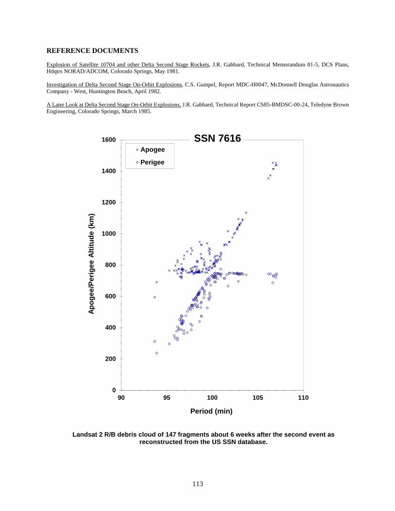
113
REFERENCE DOCUMENTS Explosion of Satellite 10704 and other Delta Second Stage Rockets, J.R. Gabbard, Technical Memorandum 81-5, DCS Plans, Hdqtrs NORAD/ADCOM, Colorado Springs, May 1981. Investigation of Delta Second Stage On-Orbit Explosions, C.S. Gumpel, Report MDC-H0047, McDonnell Douglas Astronautics Company - West, Huntington Beach, April 1982. A Later Look at Delta Second Stage On-Orbit Explosions, J.R. Gabbard, Technical Report CS85-BMDSC-00-24, Teledyne Brown Engineering, Colorado Springs, March 1985.
Landsat 2 R/B debris cloud of 147 fragments about 6 weeks after the second event as reconstructed from the US SSN database.
0
200
400
600
800
1000
1200
1400
1600
90 95 100 105 110
Apog
ee/P
erig
ee A
ltitu
de (k
m)
Period (min)
Apogee
Perigee
SSN 7616
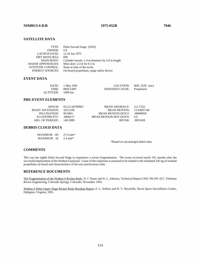
114
NIMBUS 6 R/B 1975-052B 7946 SATELLITE DATA TYPE: Delta Second Stage (2910) OWNER: US LAUNCH DATE: 12.34 Jun 1975 DRY MASS (KG): 840 MAIN BODY: Cylinder-nozzle; 1.4 m diameter by 5.8 m length MAJOR APPENDAGES: Mini-skirt; 2.4 m by 0.3 m ATTITUDE CONTROL: None at time of the event. ENERGY SOURCES: On-board propellants, range safety device EVENT DATA DATE: 1 May 1991 LOCATION: 66N, 322E (asc) TIME: 0856 GMT ASSESSED CAUSE: Propulsion ALTITUDE: 1090 km PRE-EVENT ELEMENTS EPOCH: 91112.56709963 MEAN ANOMALY: 211.7525 RIGHT ASCENSION: 329.2109 MEAN MOTION: 13.43007146 INCLINATION: 99.5801 MEAN MOTION DOT/2: .00000050 ECCENTRICITY: .0006217 MEAN MOTION DOT DOT/6: 0.0 ARG. OF PERIGEE: 148.3989 BSTAR: .0055458 DEBRIS CLOUD DATA MAXIMUM ∆P: 27.4 min* MAXIMUM ∆I: 2.4 min* *Based on uncataloged debris data COMMENTS This was the eighth Delta Second Stage to experience a severe fragmentation. The event occurred nearly 191 months after the successful deployment of the Nimbus 6 payload. Cause of the explosion is assessed to be related to the estimated 245 kg of residual propellants on board and characteristics of the sun-synchronous orbit. REFERENCE DOCUMENTS The Fragmentation of the Nimbus 6 Rocket Body, D. J. Nauer and N. L. Johnson, Technical Report CS91-TR-JSC-017, Teledyne Brown Engineering, Colorado Springs, Colorado, November 1991. Nimbus 6 Delta Upper Stage Rocket Body Breakup Report, E. L. Jenkins and H. V. Reynolds, Naval Space Surveillance Center, Dahlgren, Virginia, 1991.
115
Nimbus 6 R/B debris cloud of 386 identified fragments within 1 week after the event as reconstructed from Naval Space Surveillance System database. This diagram is taken from
the first cited reference.
0
500
1000
1500
2000
2500
3000
3500
4000
4500
96 106 116 126 136
Apog
ee/P
erig
ee A
ltitu
de (k
m)
Period (min)
Apogee
Perigee
SSN 7946

116
COSMOS 758 1975-080A 8191 SATELLITE DATA TYPE: Payload OWNER: CIS LAUNCH DATE: 5.62 Sep 1975 DRY MASS (KG): 5700 MAIN BODY: Cone-cylinder; 2.7 m diameter by 6.3 m length MAJOR APPENDAGES: Solar panels ATTITUDE CONTROL: Active, 3-axis ENERGY SOURCES: On-board propellants, explosive charge EVENT DATA DATE: 6 Sep 1975 LOCATION: 32N, 293E (asc) TIME: 1906 GMT ASSESSED CAUSE: Deliberate ALTITUDE: 185 km PRE-EVENT ELEMENTS EPOCH: 75249.72782895 MEAN ANOMALY: 294.2107 RIGHT ASCENSION: 189.2795 MEAN MOTION: 16.09422927 INCLINATION: 67.1445 MEAN MOTION DOT/2: .00430774 ECCENTRICITY: .0113994 MEAN MOTION DOT DOT/6: .0 ARG. OF PERIGEE: 67.1020 BSTAR: .0 DEBRIS CLOUD DATA MAXIMUM ∆P: Unknown MAXIMUM ∆I: Unknown COMMENTS Spacecraft was apparently destroyed after a malfunction prevented controlled reentry and landing in the Soviet Union. Most debris reentered before being officially cataloged. All but three official fragments were cataloged without elements. REFERENCE DOCUMENT History of Soviet/Russian Satellite Fragmentations-A Joint U.S.-Russian Investigation, N. L. Johnson et al, Kaman Sciences Corporation, October 1995.

117
Insufficient data to construct a Gabbard diagram.
118
COSMOS 777 1975-102A 8416 SATELLITE DATA TYPE: Payload OWNER: CIS LAUNCH DATE: 29.46 Oct 1975 DRY MASS (KG): 3000 MAIN BODY: Cylinder; 1.3 m diameter by 17 m length MAJOR APPENDAGES: Solar panels ATTITUDE CONTROL: Active, 3-axis ENERGY SOURCES: On-board propellants, explosive charge (?) EVENT DATA DATE: 25 Jan 1976 LOCATION: 53N, 7E (asc) TIME: 1400 GMT ASSESSED CAUSE: Unknown ALTITUDE: 440 km PRE-EVENT ELEMENTS EPOCH: 76025.37753295 MEAN ANOMALY: 88.9272 RIGHT ASCENSION: 303.6319 MEAN MOTION: 15.43461781 INCLINATION: 65.0177 MEAN MOTION DOT/2: .00000373 ECCENTRICITY: .0009065 MEAN MOTION DOT DOT/6: .0 ARG. OF PERIGEE: 271.0782 BSTAR: .0 DEBRIS CLOUD DATA MAXIMUM ∆P: 1.6 min MAXIMUM ∆I: 0.4 deg COMMENTS Cosmos 777 was the second spacecraft of the Cosmos 699-type to experience a fragmentation. It is the only one to breakup before terminating its precise orbit maintenance pattern and entering a regime of natural decay. A second event may have occurred about 90 minutes after the event cited above. REFERENCE DOCUMENTS "Artificial Satellite Break-Ups (Part 1): Soviet Ocean Surveillance Satellites", N. L. Johnson, Journal of the British Interplanetary Society, February 1983, pp. 51-58. History of Soviet/Russian Satellite Fragmentations-A Joint U.S.-Russian Investigation, N. L. Johnson et al, Kaman Sciences Corporation, October 1995.

119
Cosmos 777 debris cloud of 35 fragments about 10 days after the event as reconstructed from the US SSN database. Some drag effects are already evident.
300
400
500
600
700
91 92 93 94 95 96
Apog
ee/P
erig
ee A
ltitu
de (k
m)
Period (min)
Apogee
Perigee
SSN 8416

120
COSMOS 838 1976-063A 8932 SATELLITE DATA TYPE: Payload OWNER: CIS LAUNCH DATE: 2.44 Jul 1976 DRY MASS (KG): 3000 MAIN BODY: Cylinder; 1.3 m diameter by 17 m length MAJOR APPENDAGES: Solar panels ATTITUDE CONTROL: Active, 3-axis ENERGY SOURCES: On-board propellants, explosive charge (?) EVENT DATA DATE: 17 May 1977 LOCATION: 9S, 284E (dsc) TIME: 1018 GMT ASSESSED CAUSE: Unknown ALTITUDE: 430 km PRE-EVENT ELEMENTS EPOCH: 77136.94211102 MEAN ANOMALY: 73.5502 RIGHT ASCENSION: 131.3837 MEAN MOTION: 15.45822335 INCLINATION: 65.0556 MEAN MOTION DOT/2: .00007521 ECCENTRICITY: .0021270 MEAN MOTION DOT DOT/6: .0 ARG. OF PERIGEE: 286.3253 BSTAR: .0 DEBRIS CLOUD DATA MAXIMUM ∆P: 8.0 min* MAXIMUM ∆I: 1.1 deg* *Based on uncataloged debris data COMMENTS Cosmos 838 was the third spacecraft of the Cosmos 699-type to experience a fragmentation. Spacecraft had been in a regime of natural decay for 6 months prior to the event. Many debris reentered before being officially cataloged. REFERENCE DOCUMENTS "Artificial Satellite Break-Ups (Part 1): Soviet Ocean Surveillance Satellites", N. L. Johnson, Journal of the British Interplanetary Society, February 1983, pp. 51-58. History of Soviet/Russian Satellite Fragmentations-A Joint U.S.-Russian Investigation, N. L. Johnson et al, Kaman Sciences Corporation, October 1995.
121
Cosmos 838 debris cloud of 59 fragments about 1 week after the event as reconstructed from the US SSN database.
0
200
400
600
800
1000
1200
1400
90 92 94 96 98 100 102
Apog
ee/P
erig
ee A
ltitu
de (k
m)
Period (min)
Apogee
Perigee
SSN 8932
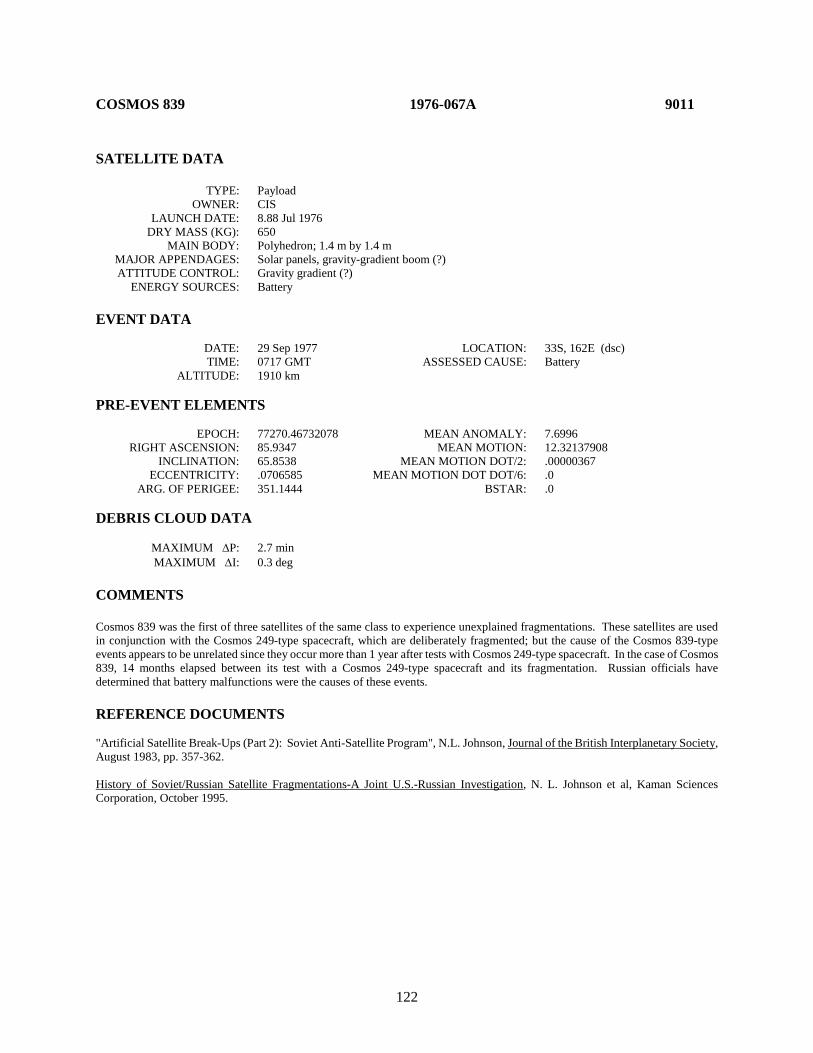
122
COSMOS 839 1976-067A 9011 SATELLITE DATA TYPE: Payload OWNER: CIS LAUNCH DATE: 8.88 Jul 1976 DRY MASS (KG): 650 MAIN BODY: Polyhedron; 1.4 m by 1.4 m MAJOR APPENDAGES: Solar panels, gravity-gradient boom (?) ATTITUDE CONTROL: Gravity gradient (?) ENERGY SOURCES: Battery EVENT DATA DATE: 29 Sep 1977 LOCATION: 33S, 162E (dsc) TIME: 0717 GMT ASSESSED CAUSE: Battery ALTITUDE: 1910 km PRE-EVENT ELEMENTS EPOCH: 77270.46732078 MEAN ANOMALY: 7.6996 RIGHT ASCENSION: 85.9347 MEAN MOTION: 12.32137908 INCLINATION: 65.8538 MEAN MOTION DOT/2: .00000367 ECCENTRICITY: .0706585 MEAN MOTION DOT DOT/6: .0 ARG. OF PERIGEE: 351.1444 BSTAR: .0 DEBRIS CLOUD DATA MAXIMUM ∆P: 2.7 min MAXIMUM ∆I: 0.3 deg COMMENTS Cosmos 839 was the first of three satellites of the same class to experience unexplained fragmentations. These satellites are used in conjunction with the Cosmos 249-type spacecraft, which are deliberately fragmented; but the cause of the Cosmos 839-type events appears to be unrelated since they occur more than 1 year after tests with Cosmos 249-type spacecraft. In the case of Cosmos 839, 14 months elapsed between its test with a Cosmos 249-type spacecraft and its fragmentation. Russian officials have determined that battery malfunctions were the causes of these events. REFERENCE DOCUMENTS "Artificial Satellite Break-Ups (Part 2): Soviet Anti-Satellite Program", N.L. Johnson, Journal of the British Interplanetary Society, August 1983, pp. 357-362. History of Soviet/Russian Satellite Fragmentations-A Joint U.S.-Russian Investigation, N. L. Johnson et al, Kaman Sciences Corporation, October 1995.
123
Cosmos 839 debris cloud of 33 fragments about 5 weeks after the event as reconstructed from the US SSN database.
500
1000
1500
2000
2500
115 116 117 118 119 120
Apog
ee/P
erig
ee A
ltitu
de (k
m)
Period (min)
Apogee
Perigee
SSN 9011

124
COSMOS 844 1976-072A 9046 SATELLITE DATA TYPE: Payload OWNER: CIS LAUNCH DATE: 22.66 Jul 1976 DRY MASS (KG): 5700 MAIN BODY: Cone-cylinder; 2.7 m diameter by 6.3 m length MAJOR APPENDAGES: Solar panels ATTITUDE CONTROL: Active, 3-axis ENERGY SOURCES: On-board propellants, explosive charge (?) EVENT DATA DATE: 25 Jul 1976 LOCATION: 49N, 100E (dsc) TIME: 1718 GMT ASSESSED CAUSE: Deliberate ALTITUDE: 210 km PRE-EVENT ELEMENTS EPOCH: 76207.45032150 MEAN ANOMALY: 291.2246 RIGHT ASCENSION: 152.6930 MEAN MOTION: 16.04433196 INCLINATION: 67.1467 MEAN MOTION DOT/2: .00313532 ECCENTRICITY: .0136374 MEAN MOTION DOT DOT/6: .0 ARG. OF PERIGEE: 70.3553 BSTAR: .0 DEBRIS CLOUD DATA MAXIMUM ∆P: Unknown MAXIMUM ∆I: Unknown COMMENTS Spacecraft was apparently destroyed after a malfunction prevented controlled reentry and landing in the Soviet Union. No elements were cataloged on any of the official debris. Most fragments reentered rapidly. REFERENCE DOCUMENT History of Soviet/Russian Satellite Fragmentations-A Joint U.S.-Russian Investigation, N. L. Johnson et al, Kaman Sciences Corporation, October 1995.

125
Insufficient data to construct a Gabbard diagram.
126
NOAA 5 R/B 1976-077B 9063 SATELLITE DATA TYPE: Delta Second Stage (2310) OWNER: US LAUNCH DATE: 29.71 Jul 1976 DRY MASS (KG): 840 MAIN BODY: Cylinder-nozzle; 1.4 m diameter by 5.8 m length MAJOR APPENDAGES: Mini-skirt; 2.4 m by 0.3 m ATTITUDE CONTROL: None at time of the event. ENERGY SOURCES: On-board propellants, range safety device EVENT DATA DATE: 24 Dec 1977 LOCATION: 40S, 146E (asc) TIME: 1133 GMT ASSESSED CAUSE: Propulsion ALTITUDE: 1510 km PRE-EVENT ELEMENTS EPOCH: 77354.53228225 MEAN ANOMALY: 330.8663 RIGHT ASCENSION: 38.5560 MEAN MOTION: 12.38394892 INCLINATION: 102.0192 MEAN MOTION DOT/2: .0 ECCENTRICITY: .0010085 MEAN MOTION DOT DOT/6: .0 ARG. OF PERIGEE: 29.2920 BSTAR: .0 DEBRIS CLOUD DATA MAXIMUM ∆P: 12.5 min MAXIMUM ∆I: 3.0 deg COMMENTS This was the sixth Delta Second Stage to experience a severe fragmentation. The event occurred 17 months after the successful deployment of the NOAA 5 payload. Cause of the explosion is assessed to be related to the estimated 250 kg of residual propellants on board and characteristics of the sun-synchronous orbit. REFERENCE DOCUMENTS Explosion of Satellite 10704 and other Delta Second Stage Rockets, J.R. Gabbard, Technical Memorandum 81-5, DCS Plans, Hdqtrs NORAD/ADCOM, Colorado Springs, May 1981. Investigation of Delta Second Stage On-Orbit Explosions, C.S. Gumpel, Report MDC-H0047, McDonnell Douglas Astronautics Company - West, Huntington Beach, April 1982. A Later Look at Delta Second Stage On-Orbit Explosions, J.R. Gabbard, Technical Report CS85-BMDSC-00-24, Teledyne Brown Engineering, Colorado Springs, March 1985.

127
NOAA 5 R/B debris cloud of 98 fragments about 4 months after the event as reconstructed from the US SSN database.
1000
1500
2000
2500
3000
110 115 120 125 130
Apog
ee/P
erig
ee A
ltitu
de (k
m)
Period (min)
Apogee
Perigee
SSN 9063
128
COSMOS 862 1976-105A 9495 SATELLITE DATA TYPE: Payload OWNER: CIS LAUNCH DATE: 22.38 Oct 1976 DRY MASS (KG): 1250 MAIN BODY: Cylinder; 1.7 m diameter by 2 m length MAJOR APPENDAGES: Solar panels ATTITUDE CONTROL: Active, 3-axis ENERGY SOURCES: On-board propellants, explosive device EVENT DATA DATE: 15 Mar 1977 LOCATION: 39N, 114E (asc) TIME: 1256 GMT ASSESSED CAUSE: Deliberate ALTITUDE: 5375 km PRE-EVENT ELEMENTS EPOCH: 77066.03986408 MEAN ANOMALY: 4.4196 RIGHT ASCENSION: 98.8078 MEAN MOTION: 2.00311741 INCLINATION: 63.1553 MEAN MOTION DOT/2: .0 ECCENTRICITY: .7312859 MEAN MOTION DOT DOT/6: .0 ARG. OF PERIGEE: 318.6653 BSTAR: .0 DEBRIS CLOUD DATA MAXIMUM ∆P: 5.7 min MAXIMUM ∆I: 0.4 deg COMMENTS Cosmos 862 was the first of a new class of operational satellites in highly elliptical, semi-synchronous orbits that experienced a total of 16 fragmentations during the period 1977-1986. Due to the nature of these orbits, which result in high altitudes over the Northern Hemisphere where most surveillance sensors are located, debris detection and tracking is extremely difficult. Only the largest fragments can be seen. Cosmos 862 spacecraft were equipped with self-destruct packages in the event that spacecraft control was lost; this was the cause of breakups until the explosives were removed after Cosmos 1481. REFERENCE DOCUMENT History of Soviet/Russian Satellite Fragmentations-A Joint U.S.-Russian Investigation, N. L. Johnson et al, Kaman Sciences Corporation, October 1995.

129
Cosmos 862 debris cloud of 10 cataloged fragments 2 weeks after the event as reconstructed from the US SSN database.
0
5000
10000
15000
20000
25000
30000
35000
40000
45000
50000
715 717 719 721 723 725
Apog
ee/P
erig
ee A
ltitu
de (k
m)
Period (min)
Apogee
Perigee
SSN 9495
130
COSMOS 880 1976-120A 9601 SATELLITE DATA TYPE: Payload OWNER: CIS LAUNCH DATE: 9.84 Dec 1976 DRY MASS (KG): 650 MAIN BODY: Polyhedron; 1.4 m by 1.4 m MAJOR APPENDAGES: Solar panels, gravity-gradient boom (?) ATTITUDE CONTROL: Gravity gradient (?) ENERGY SOURCES: Battery EVENT DATA DATE: 27 Nov 1978 LOCATION: 65S, 306E (dsc) TIME: 1703 GMT ASSESSED CAUSE: Battery ALTITUDE: 560 km PRE-EVENT ELEMENTS EPOCH: 78331.59395829 MEAN ANOMALY: 55.5772 RIGHT ASCENSION: 11.0317 MEAN MOTION: 14.93841919 INCLINATION: 65.8440 MEAN MOTION DOT/2: .00000004 ECCENTRICITY: .0050108 MEAN MOTION DOT DOT/6: .0 ARG. OF PERIGEE: 304.0553 BSTAR: .0 DEBRIS CLOUD DATA MAXIMUM ∆P: 1.3 min* MAXIMUM ∆I: 0.0 deg* *Based on uncataloged debris data COMMENTS Cosmos 880 was the second spacecraft of the Cosmos 839-type to experience a fragmentation. Although these satellites are used in conjunction with the Cosmos 249-type spacecraft that are deliberately fragmented, the cause of the Cosmos 839-type events appears to be unrelated. In the case of Cosmos 880, 23 months elapsed since its test with a Cosmos 249-type spacecraft. Russian officials have determined that battery malfunctions were the cause of these events. REFERENCE DOCUMENTS "Artificial Satellite Break-Ups (Part 2): Soviet Anti-Satellite Program", N.L. Johnson, Journal of the British Interplanetary Society, August 1983, pp. 357-362. History of Soviet/Russian Satellite Fragmentations-A Joint U.S.-Russian Investigation, N. L. Johnson et al, Kaman Sciences Corporation, October 1995.

131
Cosmos 880 debris cloud of 40 fragments 2 days after the event as reconstructed from the US SSN database.
400
500
600
700
800
95 96 97 98
Apog
ee/P
erig
ee A
ltitu
de (k
m)
Period (min)
Apogee
Perigee
SSN 9601

132
COSMOS 884 1976-123A 9614 SATELLITE DATA TYPE: Payload OWNER: CIS LAUNCH DATE: 17.40 Dec 1976 DRY MASS (KG): 6300 MAIN BODY: Sphere-cylinder; 2.4 m diameter by 6.5 m length MAJOR APPENDAGES: None ATTITUDE CONTROL: Active, 3-axis ENERGY SOURCES: On-board propellants, explosive charge EVENT DATA DATE: 29 Dec 1976 LOCATION: Unknown TIME: Unknown ASSESSED CAUSE: Deliberate ALTITUDE: Unknown PRE-EVENT ELEMENTS EPOCH: 76362.45360574 MEAN ANOMALY: 302.3648 RIGHT ASCENSION: 227.6719 MEAN MOTION: 16.11011505 INCLINATION: 65.0214 MEAN MOTION DOT/2: 0.00147448 ECCENTRICITY: 0.0113306 MEAN MOTION DOT DOT/6: 0 ARG. OF PERIGEE: 58.8529 BSTAR: 0 DEBRIS CLOUD DATA MAXIMUM ∆P: Unknown MAXIMUM ∆I: Unknown COMMENTS Spacecraft was destroyed after a malfunction prevented reentry and landing in the Soviet Union. Event identified by Russian officials during investigation cited below. REFERENCE DOCUMENT History of Soviet/Russian Satellite Fragmentations-A Joint U.S.-Russian Investigation, N. L. Johnson et al, Kaman Sciences Corporation, October 1995.

133
Insufficient data to construct a Gabbard diagram.

134
COSMOS 886 1976-126A 9634 SATELLITE DATA TYPE: Payload OWNER: CIS LAUNCH DATE: 27.53 Dec 1976 DRY MASS (KG): 1400 MAIN BODY: Irregular; 1.8 m by 4.2 m MAJOR APPENDAGES: None ATTITUDE CONTROL: Active, 3-axis ENERGY SOURCES: On-board propellants, explosive charge EVENT DATA DATE: 27 Dec 1976 LOCATION: 65S, 210E (asc) TIME: 1840 GMT ASSESSED CAUSE: Deliberate ALTITUDE: 2090 km POST-EVENT ELEMENTS EPOCH: 76362.79720829 MEAN ANOMALY: 313.0540 RIGHT ASCENSION: 306.5669 MEAN MOTION: 12.54457816 INCLINATION: 65.8434 MEAN MOTION DOT/2: .00004000 ECCENTRICITY: .1087102 MEAN MOTION DOT DOT/6: .0 ARG. OF PERIGEE: 57.0236 BSTAR: .0 DEBRIS CLOUD DATA MAXIMUM ∆P: 4.3 min MAXIMUM ∆I: 0.2 deg COMMENTS Cosmos 886 was launched on a two-revolution rendezvous with Cosmos 880. After a close approach, Cosmos 886 continued on before its warhead was intentionally fired. Cosmos 886 was part of test series begun with Cosmos 249. The elements above are the first available after the final maneuver of Cosmos 886 but represent the revolution immediately after the event. REFERENCE DOCUMENTS "Artificial Satellite Break-Ups (Part 2): Soviet Anti-Satellite Program", N.L. Johnson, Journal of the British Interplanetary Society, August 1983, pp. 357-362. History of Soviet/Russian Satellite Fragmentations-A Joint U.S.-Russian Investigation, N. L. Johnson et al, Kaman Sciences Corporation, October 1995.
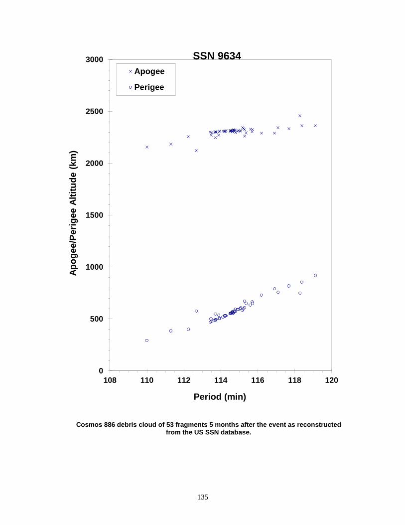
135
Cosmos 886 debris cloud of 53 fragments 5 months after the event as reconstructed from the US SSN database.
0
500
1000
1500
2000
2500
3000
108 110 112 114 116 118 120
Apog
ee/P
erig
ee A
ltitu
de (k
m)
Period (min)
Apogee
Perigee
SSN 9634

136
COSMOS 903 1977-027A 9911 SATELLITE DATA TYPE: Payload OWNER: CIS LAUNCH DATE: 11.07 Apr 1977 DRY MASS (KG): 1250 MAIN BODY: Cylinder; 1.7 m diameter by 2 m length MAJOR APPENDAGES: Solar panels ATTITUDE CONTROL: Active, 3-axis ENERGY SOURCES: On-board propellants, explosive charge EVENT DATA DATE: 8 Jun 1978 LOCATION: Unknown TIME: Unknown ASSESSED CAUSE: Deliberate ALTITUDE: Unknown PRE-EVENT ELEMENTS EPOCH: 78156.86414074 MEAN ANOMALY: 5.0496 RIGHT ASCENSION: 115.5660 MEAN MOTION: 2.00599850 INCLINATION: 63.1514 MEAN MOTION DOT/2: .0 ECCENTRICITY: .7100107 MEAN MOTION DOT DOT/6: .0 ARG. OF PERIGEE: 319.7397 BSTAR: .0 DEBRIS CLOUD DATA MAXIMUM ∆P: 2.6 min* MAXIMUM ∆I: 0.5 deg* *See Comments COMMENTS Cosmos 903 was another spacecraft of the Cosmos 862-type to experience a fragmentation. One new fragment was cataloged within a week of the event. The ∆P and ∆I values above are based on the lower period (717.5 min) orbit of Cosmos 903 after the event. REFERENCE DOCUMENT History of Soviet/Russian Satellite Fragmentations-A Joint U.S.-Russian Investigation, N. L. Johnson et al, Kaman Sciences Corporation, October 1995.

137
Cosmos 903 and a single piece of debris 3 weeks after the event as reconstructed from the US SSN database.
0
5000
10000
15000
20000
25000
30000
35000
40000
45000
714 715 716 717 718
Apog
ee/P
erig
ee A
ltitu
de (k
m)
Period (min)
Apogee
Perigee
SSN 9911
138
COSMOS 917 1977-047A 10059 SATELLITE DATA TYPE: Payload OWNER: CIS LAUNCH DATE: 16.08 Jun 1977 DRY MASS (KG): 1250 MAIN BODY: Irregular; 1.7 m by 2 m MAJOR APPENDAGES: Solar panels ATTITUDE CONTROL: Active, 3-axis ENERGY SOURCES: On-board propellants, explosive charge EVENT DATA DATE: 30 March 1979 LOCATION: 63S, 0E (dsc) TIME: 1545 GMT ASSESSED CAUSE: Deliberate ALTITUDE: 3280 km PRE-EVENT ELEMENTS EPOCH: 79089.17562851 MEAN ANOMALY: 5.2297 RIGHT ASCENSION: 156.1576 MEAN MOTION: 2.00553521 INCLINATION: 62.9498 MEAN MOTION DOT/2: .0 ECCENTRICITY: .6980052 MEAN MOTION DOT DOT/6: .0 ARG. OF PERIGEE: 322.3289 BSTAR: .0 DEBRIS CLOUD DATA MAXIMUM ∆P: 22.6 min* MAXIMUM ∆I: 0.6 deg* *Based on uncataloged debris data COMMENTS Cosmos 917 was another spacecraft of the Cosmos 862-type to experience a fragmentation. REFERENCE DOCUMENT History of Soviet/Russian Satellite Fragmentations-A Joint U.S.-Russian Investigation, N. L. Johnson et al, Kaman Sciences Corporation, October 1995.

139
Cosmos 917 debris cloud of 12 fragments about 3 weeks after the event as reconstructed from the US SSN database.
0
5000
10000
15000
20000
25000
30000
35000
40000
45000
670 690 710 730 750
Apog
ee/P
erig
ee A
ltitu
de (k
m)
Period (min)
Apogee
Perigee
SSN 10059
140
HIMAWARI 1 R/B 1977-065B 10144 SATELLITE DATA TYPE: Delta Second Stage (2914) OWNER: US LAUNCH DATE: 14.44 Jul 1977 DRY MASS (KG): 900 MAIN BODY: Cylinder-nozzle; 1.4 m diameter by 5.8 m length MAJOR APPENDAGES: Mini-skirt; 2.4 m by 0.3 m ATTITUDE CONTROL: None at time of the event. ENERGY SOURCES: On-board propellants, range safety device EVENT DATA DATE: 14 Jul 1977 LOCATION: 14N, 249E (dsc) TIME: 1612 GMT ASSESSED CAUSE: Propulsion ALTITUDE: 1450 km POST-EVENT ELEMENTS EPOCH: 77197.57445278 MEAN ANOMALY: 303.2693 RIGHT ASCENSION: 262.0317 MEAN MOTION: 12.95114397 INCLINATION: 29.0493 MEAN MOTION DOT/2: .00007335 ECCENTRICITY: .0973469 MEAN MOTION DOT DOT/6: .0 ARG. OF PERIGEE: 66.7255 BSTAR: .0 DEBRIS CLOUD DATA MAXIMUM ∆P: 9.7 min* MAXIMUM ∆I: 3.0 deg* *Based on uncataloged debris data COMMENTS This was the fifth Delta Second Stage to experience a severe fragmentation. It is also the only one that was not in a sun-synchronous orbit, which had performed a depletion burn, and which fragmented on the day of launch. This rocket body did perform its mission successfully, carrying the third stage and the payload into a low Earth orbit. The energy for the breakup is assessed to have been the 40 kg of propellants (mainly oxidizer) remaining after the depletion burn. The elements above are the first available after the depletion burn although also after the event. REFERENCE DOCUMENTS Explosion of Satellite 10704 and other Delta Second Stage Rockets, J.R. Gabbard, Technical Memorandum 81-5, DCS Plans, Hdqtrs NORAD/ADCOM, Colorado Springs, May 1981. Investigation of Delta Second Stage On-Orbit Explosions, C.S. Gumpel, Report MDC-H0047, McDonnell Douglas Astronautics Company - West, Huntington Beach, April 1982. A Later Look at Delta Second Stage On-Orbit Explosions, J.R. Gabbard, Technical Report CS85-BMDSC-00-24, Teledyne Brown Engineering, Colorado Springs, March 1985.

141
Himawari 1 R/B debris cloud of 132 fragments 5 months after the event as reconstructed from the US SSN database.
0
400
800
1200
1600
2000
2400
2800
102 107 112 117 122
Apog
ee/P
erig
ee A
ltitu
de (k
m)
Period (min)
Apogee
Perigee
SSN 10144
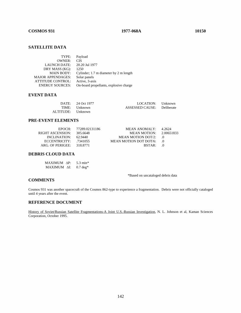
142
COSMOS 931 1977-068A 10150 SATELLITE DATA TYPE: Payload OWNER: CIS LAUNCH DATE: 20.20 Jul 1977 DRY MASS (KG): 1250 MAIN BODY: Cylinder; 1.7 m diameter by 2 m length MAJOR APPENDAGES: Solar panels ATTITUDE CONTROL: Active, 3-axis ENERGY SOURCES: On-board propellants, explosive charge EVENT DATA DATE: 24 Oct 1977 LOCATION: Unknown TIME: Unknown ASSESSED CAUSE: Deliberate ALTITUDE: Unknown PRE-EVENT ELEMENTS EPOCH: 77289.02131186 MEAN ANOMALY: 4.2624 RIGHT ASCENSION: 305.6648 MEAN MOTION: 2.00651833 INCLINATION: 62.9440 MEAN MOTION DOT/2: .0 ECCENTRICITY: .7341055 MEAN MOTION DOT DOT/6: .0 ARG. OF PERIGEE: 318.8771 BSTAR: .0 DEBRIS CLOUD DATA MAXIMUM ∆P: 5.3 min* MAXIMUM ∆I: 0.7 deg* *Based on uncataloged debris data COMMENTS Cosmos 931 was another spacecraft of the Cosmos 862-type to experience a fragmentation. Debris were not officially cataloged until 4 years after the event. REFERENCE DOCUMENT History of Soviet/Russian Satellite Fragmentations-A Joint U.S.-Russian Investigation, N. L. Johnson et al, Kaman Sciences Corporation, October 1995.
143
Cosmos 931 debris cloud of 13 fragments 2 weeks after the event as reconstructed from the US SSN database.
0
5000
10000
15000
20000
25000
30000
35000
40000
45000
50000
715 717 719 721 723 725
Apog
ee/P
erig
ee A
ltitu
de (k
m)
Period (min)
Apogee
Perigee
SSN 10150
144
EKRAN 2 1977-092A 10365 SATELLITE DATA TYPE: Payload OWNER: CIS LAUNCH DATE: 20.73 Sept 1977 DRY MASS (KG): 1750 MAIN BODY: Cone; 2 m by 4 m MAJOR APPENDAGES: Plate + 2 solar panels ATTITUDE CONTROL: Active, 3-axis ENERGY SOURCES: On-board propellants, Battery EVENT DATA DATE: 23 Jun 1978 LOCATION: 0.0N, 98.7E TIME: Unknown ASSESSED CAUSE: Battery ALTITUDE: 35790 km PRE-EVENT ELEMENTS EPOCH: 88166.03647595 MEAN ANOMALY: 78.3897 RIGHT ASCENSION: 78.3897 MEAN MOTION: 1.00252588 INCLINATION: 0.1137 MEAN MOTION DOT/2: .0 ECCENTRICITY .0001436 MEAN MOTION DOT DOT/6: .0 ARG. OF PERIGEE: 325.2771 BSTAR: .0 DEBRIS CLOUD DATA MAXIMUM ∆P: Unknown MAXIMUM ∆I: Unknown COMMENTS This event was revealed by Russian officials in an orbital debris meeting in February 1992 in Moscow. This is the first known geostationary orbit fragmentation and was not detected by the Space Surveillance Network (SSN). Russian photographs originally linked to the breakup were later determined to have been misidentified. REFERENCE DOCUMENTS History of Soviet/Russian Satellite Fragmentations-A Joint U.S.-Russian Investigation, N. L. Johnson et al, Kaman Sciences Corporation, October 1995. “Breakup in Review-Two GEO Breakups”, Orbital Debris Monitor, April 1992, p 35-36.

145
Insufficient data to construct a Gabbard diagram.
146
COSMOS 970 1977-121A 10531 SATELLITE DATA TYPE: Payload OWNER: CIS LAUNCH DATE: 21.44 Dec 1977 DRY MASS (KG): 1400 MAIN BODY: Cylinder; 2 m diameter by 4 m length MAJOR APPENDAGES: None ATTITUDE CONTROL: Active, 3-axis ENERGY SOURCES: On-board propellants, explosive charge EVENT DATA DATE: 21 Dec 1977 LOCATION: 38S, 274E (asc) TIME: 1710 GMT ASSESSED CAUSE: Deliberate ALTITUDE: 1135 km PRE-EVENT ELEMENTS EPOCH: 77355.65049149 MEAN ANOMALY: 245.5638 RIGHT ASCENSION: 282.1792 MEAN MOTION: 13.58084598 INCLINATION: 65.8467 MEAN MOTION DOT/2: .00023007 ECCENTRICITY: .0129854 MEAN MOTION DOT DOT/6: .0 ARG. OF PERIGEE: 116.3098 BSTAR: .0 DEBRIS CLOUD DATA MAXIMUM ∆P: 4.7 min MAXIMUM ∆I: 1.1 deg COMMENTS Cosmos 970 was launched on a two-revolution rendezvous with Cosmos 967. After a close approach, Cosmos 970 continued on before its warhead was intentionally fired. Cosmos 970 was part of test series begun with Cosmos 249. REFERENCE DOCUMENTS "Artificial Satellite Break-Ups (Part 2): Soviet Anti-Satellite Program", N. L. Johnson, Journal of the British Interplanetary Society, August 1983, p. 357-362. History of Soviet/Russian Satellite Fragmentations-A Joint U.S.-Russian Investigation, N. L. Johnson et al, Kaman Sciences Corporation, October 1995.

147
Cosmos 970 debris cloud of 34 fragments about 5 months after the event as reconstructed from the US SSN database.
600
800
1000
1200
1400
1600
1800
105 106 107 108 109 110 111
Apog
ee/P
erig
ee A
ltitu
de (k
m)
Period (min)
Apogee
Perigee
SSN 10531
148
LANDSAT 3 R/B 1978-026C 10704 SATELLITE DATA TYPE: Delta Second Stage (2910) OWNER: US LAUNCH DATE: 5.75 Mar 1978 DRY MASS (KG): 900 MAIN BODY: Cylinder-nozzle; 1.4 m diameter by 5.8 m length MAJOR APPENDAGES: Mini-skirt; 2.4 m by 0.3 m ATTITUDE CONTROL: None at time of the event. ENERGY SOURCES: On-board propellants, range safety device EVENT DATA DATE: 27 Jan 1981 LOCATION: 80S, 301E (asc) TIME: 0432 GMT ASSESSED CAUSE: Propulsion ALTITUDE: 910 km PRE-EVENT ELEMENTS EPOCH: 81026.99107090 MEAN ANOMALY: 147.0549 RIGHT ASCENSION: 68.7927 MEAN MOTION: 13.96108433 INCLINATION: 98.8485 MEAN MOTION DOT/2: .00000434 ECCENTRICITY: .0006255 MEAN MOTION DOT DOT/6: .0 ARG. OF PERIGEE: 212.9842 BSTAR: .00032708 DEBRIS CLOUD DATA MAXIMUM ∆P: 9.1 min MAXIMUM ∆I: 0.5 deg COMMENTS This was the seventh Delta Second Stage to experience a severe fragmentation. The event occurred nearly 35 months after the successful deployment of the Landsat 3 payload. Cause of the explosion is assessed to be related to the estimated 100 kg of residual propellants on board and characteristics of the sun-synchronous orbit. REFERENCE DOCUMENTS Explosion of Satellite 10704 and other Delta Second Stage Rockets, J.R. Gabbard, Technical Memorandum 81-5, DCS Plans, Hdqtrs NORAD/ADCOM, Colorado Springs, May 1981. Analysis of PARCS Recorded Data on the Breakup of Satellite 10704 on 27 January 1981, S.F. Hoffman and P.P. Shinkunas, Technical Report MSB82-ADC-0138, Teledyne Brown Engineering, Huntsville, February 1982. Investigation of Delta Second Stage On-Orbit Explosions, C.S. Gumpel, Report MDC-H0047, McDonnell Douglas Astronautics Company - West, Huntington Beach, April 1982. A Later Look at Delta Second Stage On-Orbit Explosions, J.R. Gabbard, Technical Report CS85-BMDSC-00-24, Teledyne Brown Engineering, Colorado Springs, March 1985.

149
Landsat 3 R/B debris cloud of 90 identified fragments 4 days after the event as reconstructed from the US SSN database.
0
200
400
600
800
1000
1200
1400
1600
1800
95 100 105 110
Apog
ee/P
erig
ee A
ltitu
de (k
m)
Period (min)
Apogee
Perigee
SSN 10704

150
COSMOS 1030 1978-083A 11015 SATELLITE DATA TYPE: Payload OWNER: CIS LAUNCH DATE: 6.13 Sep 1978 DRY MASS (KG): 1250 MAIN BODY: Cylinder; 1.7 m diameter by 2 m length MAJOR APPENDAGES: Solar panels (?) ATTITUDE CONTROL: Active, 3-axis ENERGY SOURCES: On-board propellants, explosive charge EVENT DATA DATE: 10 Oct 1978 LOCATION: Unknown TIME: Unknown ASSESSED CAUSE: Deliberate ALTITUDE: Unknown PRE-EVENT ELEMENTS EPOCH: 78277.19859350 MEAN ANOMALY: 4.9827 RIGHT ASCENSION: 336.7676 MEAN MOTION: 2.00213289 INCLINATION: 62.8388 MEAN MOTION DOT/2: .0 ECCENTRICITY: .7350882 MEAN MOTION DOT DOT/6: .0 ARG. OF PERIGEE: 318.4262 BSTAR: .0 DEBRIS CLOUD DATA MAXIMUM ∆P: Unknown MAXIMUM ∆I: Unknown COMMENTS Cosmos 1030 was another spacecraft of the Cosmos 862-type to experience a fragmentation. After entering a Molniya-type transfer orbit on 6 September, Cosmos 1030 maneuvered about 14 September to enter an operational orbit. Elements on the first identifiable fragment did not appear until a year after the event. Official cataloging of debris did not begin until 3 years after the event. REFERENCE DOCUMENT History of Soviet/Russian Satellite Fragmentations-A Joint U.S.-Russian Investigation, N. L. Johnson et al, Kaman Sciences Corporation, October 1995.

151
Cosmos 1030 and a single debris fragment 1 year after the event as reconstructed from the US SSN database.
0
5000
10000
15000
20000
25000
30000
35000
40000
45000
716 717 718 719
Apog
ee/P
erig
ee A
ltitu
de (k
m)
Period (min)
Apogee
Perigee
SSN 11015
152
NIMBUS 7 R/B 1978-098B 11081 SATELLITE DATA TYPE: Delta Second Stage (2910) OWNER: US LAUNCH DATE: 24.34 Oct 1978 DRY MASS (KG): 900 MAIN BODY: Cylinder-nozzle; 2.4 m diameter by 8 m length MAJOR APPENDAGES: None ATTITUDE CONTROL: None at time of the event. ENERGY SOURCES: On-board propellants, range safety device EVENT DATA DATE: 26 Dec 1981 LOCATION: Unknown TIME: Unknown ASSESSED CAUSE: Propulsion ALTITUDE: Unknown PRE-EVENT ELEMENTS EPOCH: 81360.19972720 MEAN ANOMALY: 311.8261 RIGHT ASCENSION: 277.7553 MEAN MOTION: 13.85390161 INCLINATION: 99.3003 MEAN MOTION DOT/2: .000000425 ECCENTRICITY: .0010821 MEAN MOTION DOT DOT/6: .0 ARG. OF PERIGEE: 48.3801 BSTAR: .00004426123 DEBRIS CLOUD DATA MAXIMUM ∆P: Unknown MAXIMUM ∆I: 0.6 deg* *Based on uncataloged debris data COMMENTS Nimbus 7 R/B is designated Cameo in US Space Command Satellite Catalog in reference to scientific piggy-back payload attached to the Delta second stage. This satellite experienced an anomalous event prior to and after the event cited above (See Section 3). Most fragments decayed very rapidly, preventing an accurate assessment of the event and its resulting debris cloud. No new objects were cataloged as a result of this event. The event apparently occurred prior to 0700 GMT.
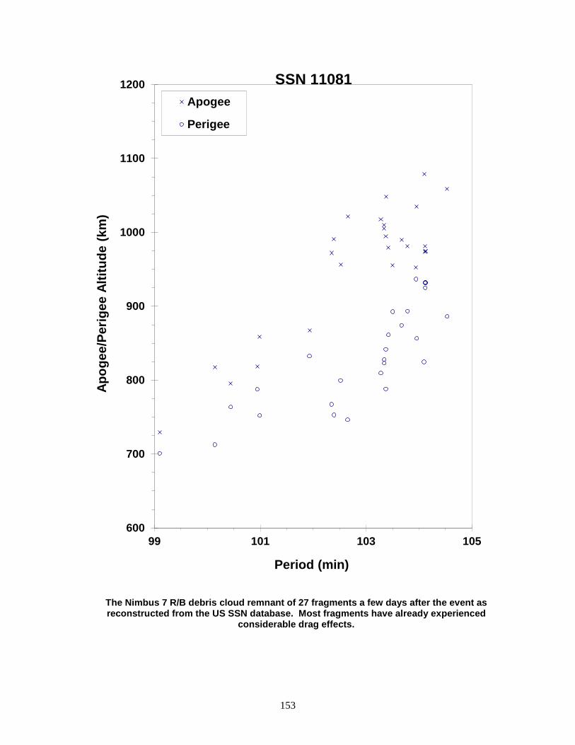
153
The Nimbus 7 R/B debris cloud remnant of 27 fragments a few days after the event as reconstructed from the US SSN database. Most fragments have already experienced
considerable drag effects.
600
700
800
900
1000
1100
1200
99 101 103 105
Apog
ee/P
erig
ee A
ltitu
de (k
m)
Period (min)
Apogee
Perigee
SSN 11081
154
COSMOS 1045 R/B 1978-100D 11087 SATELLITE DATA TYPE: Tsyklon Third Stage OWNER: CIS LAUNCH DATE: 26.29 Oct 1978 DRY MASS (KG): 1360 MAIN BODY: Cone-cylinder; 2.1 m diameter by 3.3 m length MAJOR APPENDAGES: None ATTITUDE CONTROL: None at time of the event. ENERGY SOURCES: Unknown EVENT DATA DATE: 9 May 1988 LOCATION: 29S, 126E (dsc) TIME: 1218 GMT ASSESSED CAUSE: Propulsion ALTITUDE: 1705 km PRE-EVENT ELEMENTS EPOCH: 88121.02005933 MEAN ANOMALY: 279.0818 RIGHT ASCENSION: 359.3059 MEAN MOTION: 11.97080974 INCLINATION: 82.5543 MEAN MOTION DOT/2: .000000208 ECCENTRICITY: .0011463 MEAN MOTION DOT DOT/6: .0 ARG. OF PERIGEE: 81.1553 BSTAR: .0 DEBRIS CLOUD DATA MAXIMUM ∆P: 7.8 min MAXIMUM ∆I: 0.9 deg COMMENTS This flight, which successfully carried three separate payloads, was the fifth orbital mission of the Tsyklon third stage. Propellants used were N2O4 and UDMH. Nearly 10 years elapsed from launch to breakup. A second Tsyklon third stage breakup after a similar length of time; see 1987-068B. REFERENCE DOCUMENT History of Soviet/Russian Satellite Fragmentations-A Joint U.S.-Russian Investigation, N. L. Johnson et al, Kaman Sciences Corporation, October 1995.
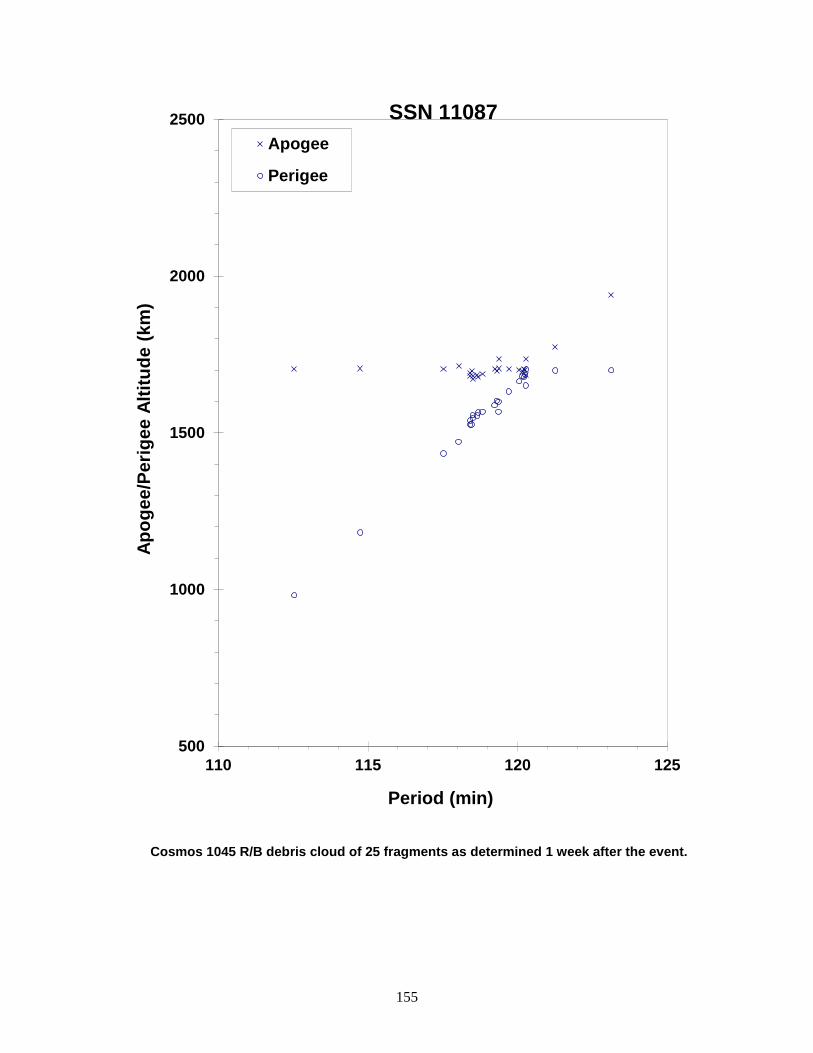
155
Cosmos 1045 R/B debris cloud of 25 fragments as determined 1 week after the event.
500
1000
1500
2000
2500
110 115 120 125
Apog
ee/P
erig
ee A
ltitu
de (k
m)
Period (min)
Apogee
Perigee
SSN 11087

156
P-78 (SOLWIND) 1979-017A 11278 SATELLITE DATA TYPE: Payload OWNER: US LAUNCH DATE: 24.35 Feb 1979 DRY MASS (KG): 850 MAIN BODY: Cylinder; 2.1 m diameter by 1.3 m length MAJOR APPENDAGES: 1 solar panel ATTITUDE CONTROL: Spin-stabilized ENERGY SOURCES: None EVENT DATA DATE: 13 Sep 1985 LOCATION: 35N, 234E (asc) TIME: 2043 GMT ASSESSED CAUSE: Deliberate ALTITUDE: 525 km PRE-EVENT ELEMENTS EPOCH: 85256.72413718 MEAN ANOMALY: 260.9644 RIGHT ASCENSION: 182.5017 MEAN MOTION: 15.11755304 INCLINATION: 97.6346 MEAN MOTION DOT/2: .00000616 ECCENTRICITY: .0022038 MEAN MOTION DOT DOT/6: .0 ARG. OF PERIGEE: 99.4081 BSTAR: .000037918 DEBRIS CLOUD DATA MAXIMUM ∆P: 12.7 min MAXIMUM ∆I: 1.4 deg COMMENTS P-78 was impacted by a sub-orbital object at high velocity as part of a planned test. REFERENCE DOCUMENT Postmortem of a Hypervelocity Impact: Summary, R. L. Kling, Technical Report CS86-LKD-001, Teledyne Brown Engineering, Colorado Springs, September 1986.
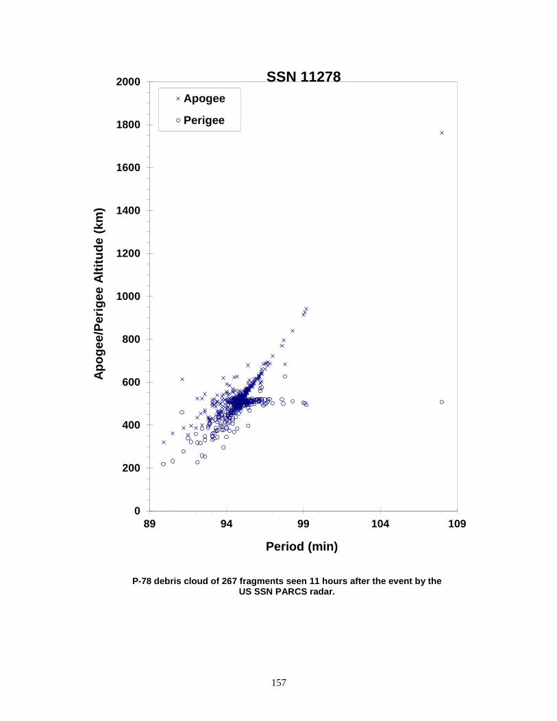
157
P-78 debris cloud of 267 fragments seen 11 hours after the event by the US SSN PARCS radar.
0
200
400
600
800
1000
1200
1400
1600
1800
2000
89 94 99 104 109
Apog
ee/P
erig
ee A
ltitu
de (k
m)
Period (min)
Apogee
Perigee
SSN 11278
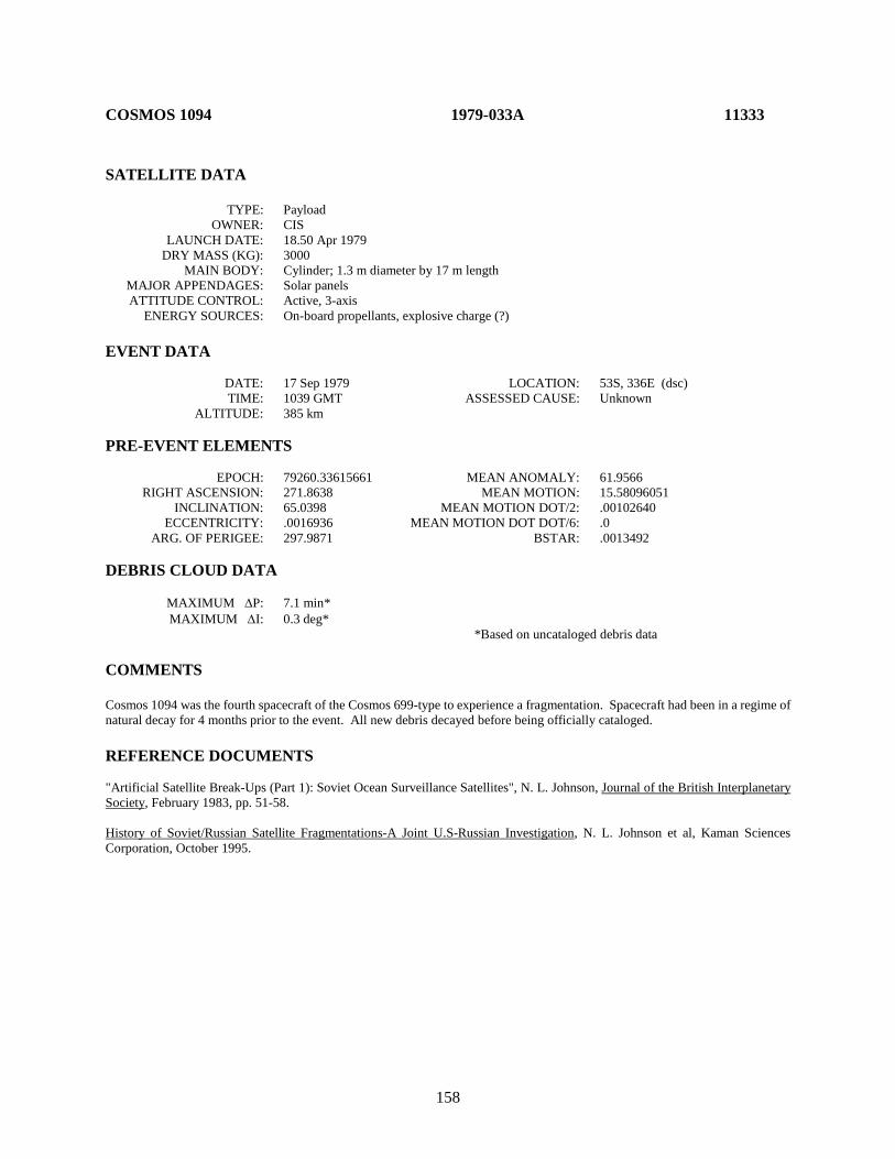
158
COSMOS 1094 1979-033A 11333 SATELLITE DATA TYPE: Payload OWNER: CIS LAUNCH DATE: 18.50 Apr 1979 DRY MASS (KG): 3000 MAIN BODY: Cylinder; 1.3 m diameter by 17 m length MAJOR APPENDAGES: Solar panels ATTITUDE CONTROL: Active, 3-axis ENERGY SOURCES: On-board propellants, explosive charge (?) EVENT DATA DATE: 17 Sep 1979 LOCATION: 53S, 336E (dsc) TIME: 1039 GMT ASSESSED CAUSE: Unknown ALTITUDE: 385 km PRE-EVENT ELEMENTS EPOCH: 79260.33615661 MEAN ANOMALY: 61.9566 RIGHT ASCENSION: 271.8638 MEAN MOTION: 15.58096051 INCLINATION: 65.0398 MEAN MOTION DOT/2: .00102640 ECCENTRICITY: .0016936 MEAN MOTION DOT DOT/6: .0 ARG. OF PERIGEE: 297.9871 BSTAR: .0013492 DEBRIS CLOUD DATA MAXIMUM ∆P: 7.1 min* MAXIMUM ∆I: 0.3 deg* *Based on uncataloged debris data COMMENTS Cosmos 1094 was the fourth spacecraft of the Cosmos 699-type to experience a fragmentation. Spacecraft had been in a regime of natural decay for 4 months prior to the event. All new debris decayed before being officially cataloged. REFERENCE DOCUMENTS "Artificial Satellite Break-Ups (Part 1): Soviet Ocean Surveillance Satellites", N. L. Johnson, Journal of the British Interplanetary Society, February 1983, pp. 51-58. History of Soviet/Russian Satellite Fragmentations-A Joint U.S-Russian Investigation, N. L. Johnson et al, Kaman Sciences Corporation, October 1995.
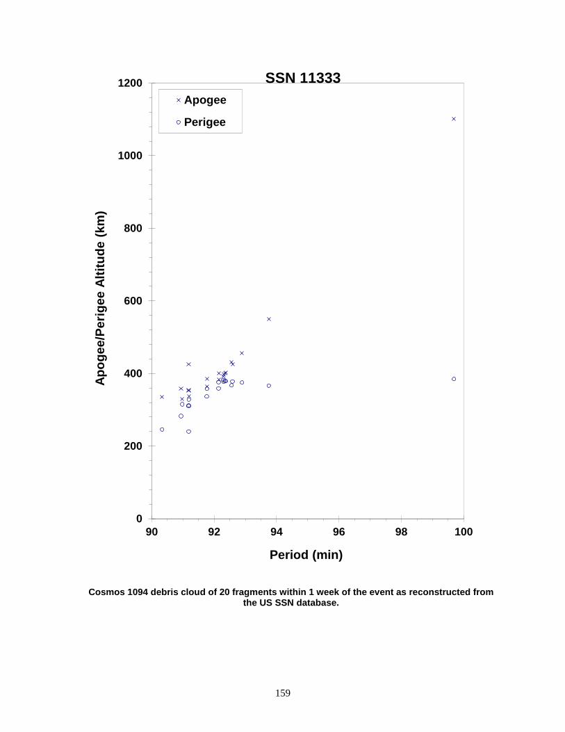
159
Cosmos 1094 debris cloud of 20 fragments within 1 week of the event as reconstructed from the US SSN database.
0
200
400
600
800
1000
1200
90 92 94 96 98 100
Apog
ee/P
erig
ee A
ltitu
de (k
m)
Period (min)
Apogee
Perigee
SSN 11333
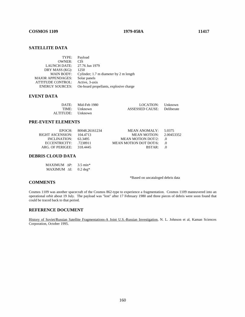
160
COSMOS 1109 1979-058A 11417 SATELLITE DATA TYPE: Payload OWNER: CIS LAUNCH DATE: 27.76 Jun 1979 DRY MASS (KG): 1250 MAIN BODY: Cylinder; 1.7 m diameter by 2 m length MAJOR APPENDAGES: Solar panels ATTITUDE CONTROL: Active, 3-axis ENERGY SOURCES: On-board propellants, explosive charge EVENT DATA DATE: Mid-Feb 1980 LOCATION: Unknown TIME: Unknown ASSESSED CAUSE: Deliberate ALTITUDE: Unknown PRE-EVENT ELEMENTS EPOCH: 80048.26161234 MEAN ANOMALY: 5.0375 RIGHT ASCENSION: 104.4713 MEAN MOTION: 2.00453352 INCLINATION: 63.3495 MEAN MOTION DOT/2: .0 ECCENTRICITY: .7238911 MEAN MOTION DOT DOT/6: .0 ARG. OF PERIGEE: 318.4445 BSTAR: .0 DEBRIS CLOUD DATA MAXIMUM ∆P: 3.5 min* MAXIMUM ∆I: 0.2 deg* *Based on uncataloged debris data COMMENTS Cosmos 1109 was another spacecraft of the Cosmos 862-type to experience a fragmentation. Cosmos 1109 maneuvered into an operational orbit about 19 July. The payload was "lost" after 17 February 1980 and three pieces of debris were soon found that could be traced back to that period. REFERENCE DOCUMENT History of Soviet/Russian Satellite Fragmentations-A Joint U.S.-Russian Investigation, N. L. Johnson et al, Kaman Sciences Corporation, October 1995.
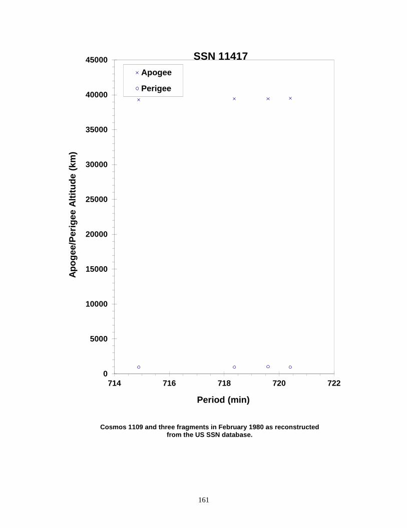
161
Cosmos 1109 and three fragments in February 1980 as reconstructed from the US SSN database.
0
5000
10000
15000
20000
25000
30000
35000
40000
45000
714 716 718 720 722
Apog
ee/P
erig
ee A
ltitu
de (k
m)
Period (min)
Apogee
Perigee
SSN 11417

162
COSMOS 1124 1979-077A 11509 SATELLITE DATA TYPE: Payload OWNER: CIS LAUNCH DATE: 28.01 Aug 1979 DRY MASS (KG): 1250 MAIN BODY: Cylinder; 1.7 m diameter by 2 m length MAJOR APPENDAGES: Solar panels ATTITUDE CONTROL: Active, 3-axis ENERGY SOURCES: On-board propellants, explosive charge EVENT DATA DATE: 9 Sep 1979 LOCATION: 52N, 304E (asc) TIME: 0230 GMT ASSESSED CAUSE: Deliberate ALTITUDE: 8375 km PRE-EVENT ELEMENTS EPOCH: 79249.09448656 MEAN ANOMALY: 3.7678 RIGHT ASCENSION: 288.1742 MEAN MOTION: 2.00548359 INCLINATION: 63.0212 MEAN MOTION DOT/2: .0 ECCENTRICITY: .7383335 MEAN MOTION DOT DOT/6: .0 ARG. OF PERIGEE: 318.3799 BSTAR: .0 DEBRIS CLOUD DATA MAXIMUM ∆P: 4.0 min* MAXIMUM ∆I: 0.1 deg* *Based on uncataloged debris data COMMENTS Cosmos 1124 was another spacecraft of the Cosmos 862-type to experience a fragmentation. After insertion into a Molniya-type transfer orbit on 28 August, Cosmos 1124's ascending node was allowed to drift until 3 September when a maneuver placed the spacecraft into an operational, semi-synchronous orbit. The fragmentation occurred 6 days later. The spacecraft never maneuvered again and soon drifted off station. REFERENCE DOCUMENT History of Soviet/Russian Satellite Fragmentations-A Joint U.S.-Russian Investigation, N. L. Johnson et al, Kaman Sciences Corporation, October 1995.
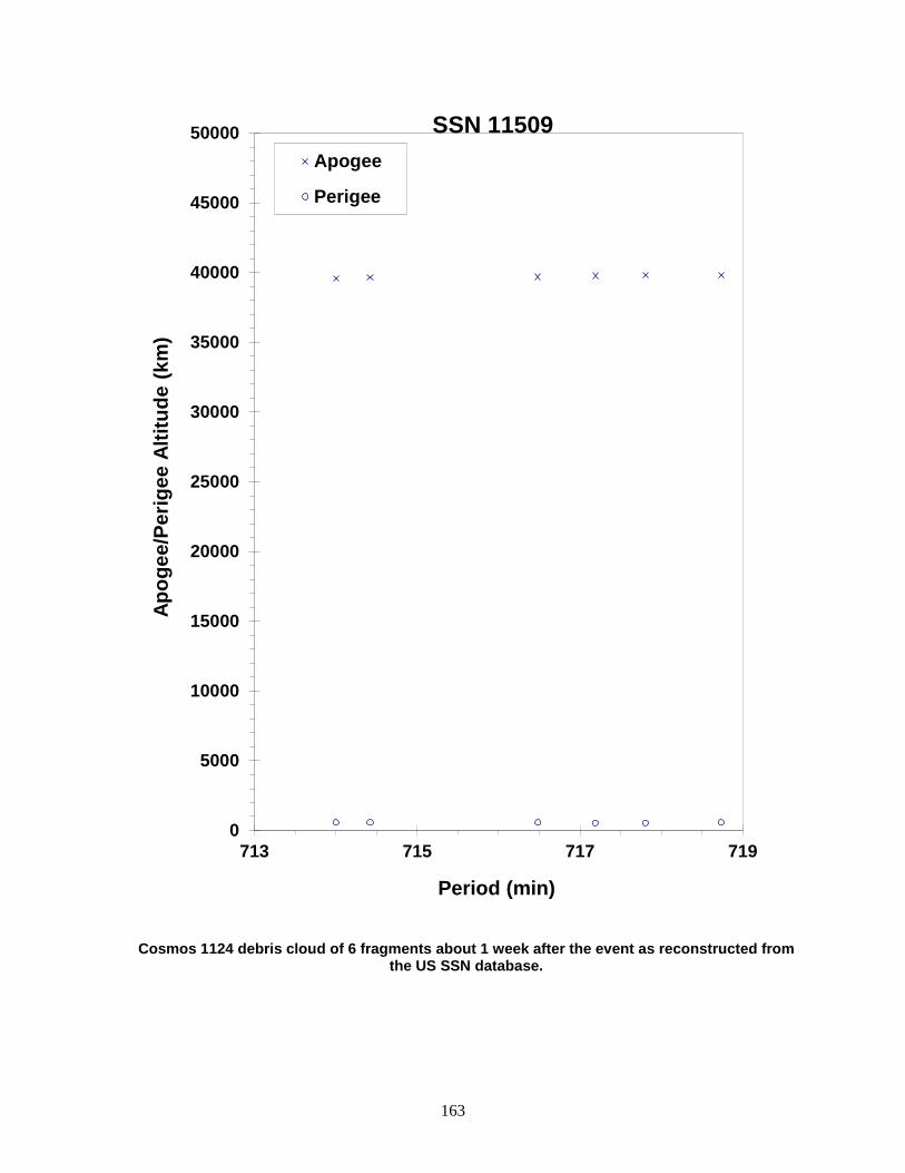
163
Cosmos 1124 debris cloud of 6 fragments about 1 week after the event as reconstructed from the US SSN database.
0
5000
10000
15000
20000
25000
30000
35000
40000
45000
50000
713 715 717 719
Apog
ee/P
erig
ee A
ltitu
de (k
m)
Period (min)
Apogee
Perigee
SSN 11509
164
SATCOM 3 1979-101A 11635 SATELLITE DATA TYPE: Payload OWNER: US LAUNCH DATE: 7.07 Dec 1979 DRY MASS (KG): 463 MAIN BODY: Box; 1.2 m length by 1.62 m length by 1.17 m height MAJOR APPENDAGES: 2 Solar Panels, antenna/feeds ATTITUDE CONTROL: Active, 3 axis ENERGY SOURCES: On-board solid AKM and liquid monopropellants EVENT DATA DATE: ~ 11 Dec 1979 LOCATION: Unknown TIME: Unknown ASSESSED CAUSE: Propulsion (solid) ALTITUDE: Unknown PRE-EVENT ELEMENTS EPOCH: 79345.24087748 MEAN ANOMALY: 174.6228 RIGHT ASCENSION: 276.7452 MEAN MOTION: 2.28199220 INCLINATION: 23.7341 MEAN MOTION DOT/2: .00044295 ECCENTRICITY: .7298759 MEAN MOTION DOT DOT/6: .0 ARG. OF PERIGEE: 181.2679 BSTAR: .000009999 POST-EVENT ELEMENTS EPOCH: 82327.71145422 MEAN ANOMALY: 349.7392 RIGHT ASCENSION: 164.2803 MEAN MOTION: 1.82544069 INCLINATION: 8.1767 MEAN MOTION DOT/2: .00000069 ECCENTRICITY: .4789421 MEAN MOTION DOT DOT/6: .0 ARG. OF PERIGEE: 31.9453 BSTAR: .0 DEBRIS CLOUD DATA MAXIMUM ∆P: Unknown MAXIMUM ∆I: Unknown COMMENTS Detected by software. This mission was the third launch of the RCA SATCOM series. Communications with payload was lost upon firing of Aerojet SVM-7 solid apogee kick motor. Detection and tracking of debris has always been extremely difficult in part due to low inclination and highly elliptical orbit. Debris entered the SSN catalog in 2006 and after. The magnitude of the event and the total number of pieces created are unknown. REFERENCE DOCUMENT
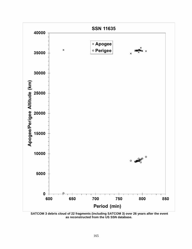
165
SATCOM 3 debris cloud of 22 fragments (including SATCOM 3) over 26 years after the event
as reconstructed from the US SSN database.
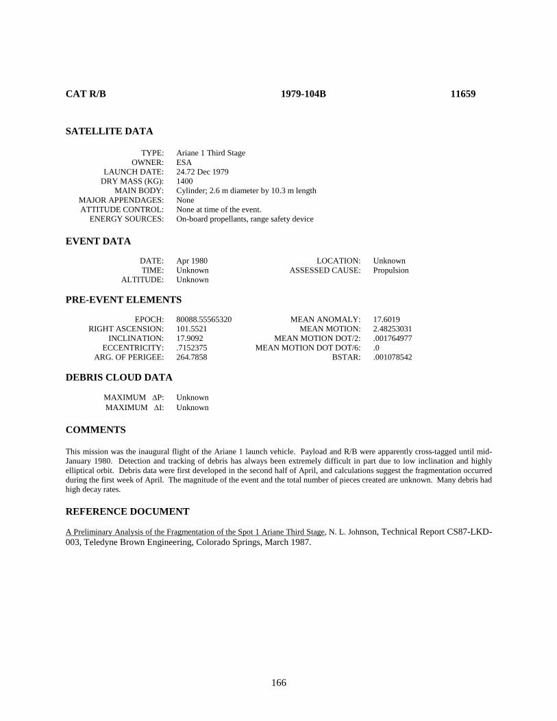
166
CAT R/B 1979-104B 11659 SATELLITE DATA TYPE: Ariane 1 Third Stage OWNER: ESA LAUNCH DATE: 24.72 Dec 1979 DRY MASS (KG): 1400 MAIN BODY: Cylinder; 2.6 m diameter by 10.3 m length MAJOR APPENDAGES: None ATTITUDE CONTROL: None at time of the event. ENERGY SOURCES: On-board propellants, range safety device EVENT DATA DATE: Apr 1980 LOCATION: Unknown TIME: Unknown ASSESSED CAUSE: Propulsion ALTITUDE: Unknown PRE-EVENT ELEMENTS EPOCH: 80088.55565320 MEAN ANOMALY: 17.6019 RIGHT ASCENSION: 101.5521 MEAN MOTION: 2.48253031 INCLINATION: 17.9092 MEAN MOTION DOT/2: .001764977 ECCENTRICITY: .7152375 MEAN MOTION DOT DOT/6: .0 ARG. OF PERIGEE: 264.7858 BSTAR: .001078542 DEBRIS CLOUD DATA MAXIMUM ∆P: Unknown MAXIMUM ∆I: Unknown COMMENTS This mission was the inaugural flight of the Ariane 1 launch vehicle. Payload and R/B were apparently cross-tagged until mid-January 1980. Detection and tracking of debris has always been extremely difficult in part due to low inclination and highly elliptical orbit. Debris data were first developed in the second half of April, and calculations suggest the fragmentation occurred during the first week of April. The magnitude of the event and the total number of pieces created are unknown. Many debris had high decay rates. REFERENCE DOCUMENT A Preliminary Analysis of the Fragmentation of the Spot 1 Ariane Third Stage, N. L. Johnson, Technical Report CS87-LKD-003, Teledyne Brown Engineering, Colorado Springs, March 1987.
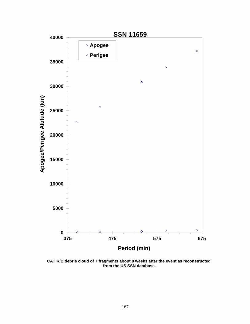
167
CAT R/B debris cloud of 7 fragments about 8 weeks after the event as reconstructed from the US SSN database.
0
5000
10000
15000
20000
25000
30000
35000
40000
375 475 575 675
Apog
ee/P
erig
ee A
ltitu
de (k
m)
Period (min)
Apogee
Perigee
SSN 11659

168
COSMOS 1167 1980-021A 11729 SATELLITE DATA TYPE: Payload OWNER: CIS LAUNCH DATE: 14.44 Mar 1980 DRY MASS (KG): 3000 MAIN BODY: Cylinder; 1.3 m diameter by 17 m length MAJOR APPENDAGES: Solar panels ATTITUDE CONTROL: Active, 3-axis ENERGY SOURCES: On-board propellants, explosive charge (?) EVENT DATA DATE: 15 Jul 1981 LOCATION: 10N, 106E (asc) TIME: 0921 GMT ASSESSED CAUSE: Unknown ALTITUDE: 430 km PRE-EVENT ELEMENTS EPOCH: 81196.19449955 MEAN ANOMALY: 110.8351 RIGHT ASCENSION: 174.9184 MEAN MOTION: 15.54665775 INCLINATION: 65.0101 MEAN MOTION DOT/2: .00025375 ECCENTRICITY: .0068471 MEAN MOTION DOT DOT/6: .0 ARG. OF PERIGEE: 248.6139 BSTAR: .00034595 DEBRIS CLOUD DATA MAXIMUM ∆P: 1.0 min* MAXIMUM ∆I: 0.5 deg* *Based on uncataloged debris data COMMENTS Cosmos 1167 was the fifth spacecraft of the Cosmos 699-type to experience a fragmentation. The spacecraft had been in a regime of natural decay for 3 months prior to the event. Most debris reentered before being officially cataloged. REFERENCE DOCUMENTS The Fragmentations of USSR Satellites 11729 and 12504 (U), J. R. Gabbard and P. M. Landry, Technical Memorandum 82-S-03, DCS/Plans, Hdqtrs NORAD/ADCOM, Colorado Springs, August 1982 (Secret). "Artificial Satellite Break-Ups (Part 1): Soviet Ocean Surveillance Satellites", N. L. Johnson, Journal of the British Interplanetary Society, February 1983, pp. 51-58. History of Soviet/Russian Satellite Fragmentations-A Joint U.S.-Russian Investigation, N. L Johnson et al, Kaman Sciences Corporation, October 1995.
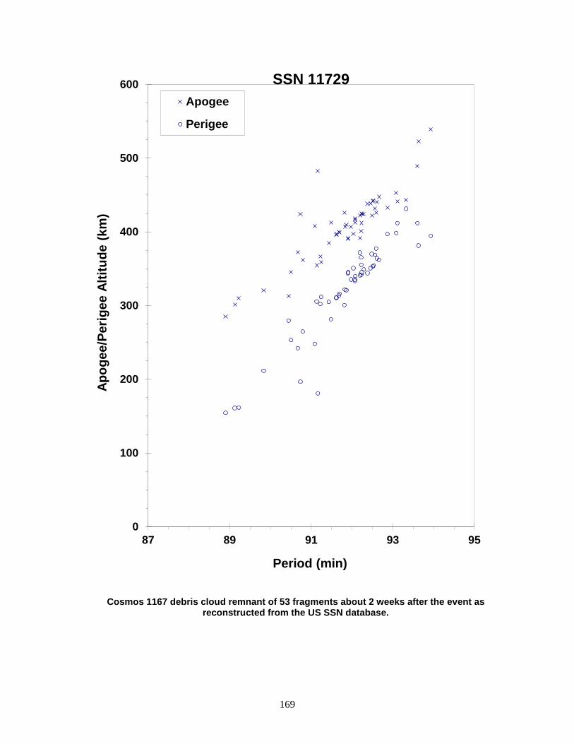
169
Cosmos 1167 debris cloud remnant of 53 fragments about 2 weeks after the event as reconstructed from the US SSN database.
0
100
200
300
400
500
600
87 89 91 93 95
Apog
ee/P
erig
ee A
ltitu
de (k
m)
Period (min)
Apogee
Perigee
SSN 11729
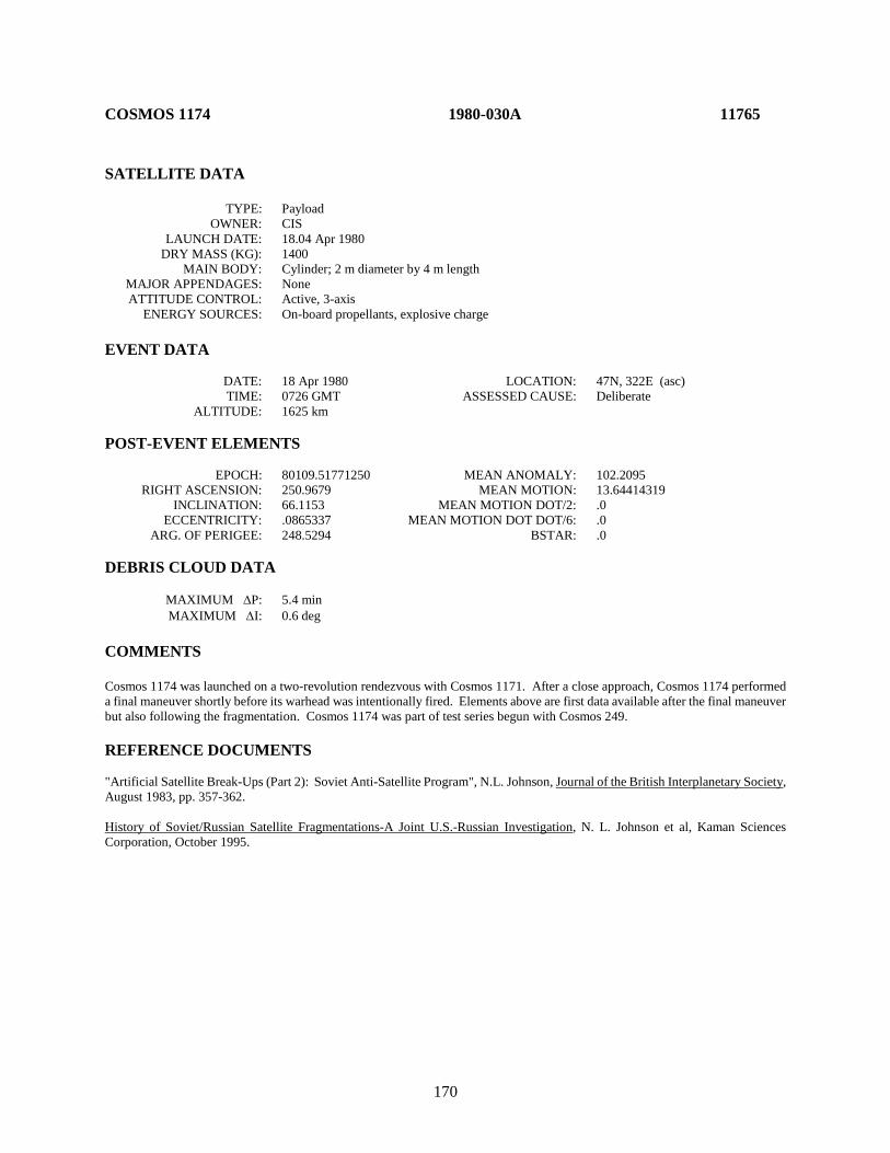
170
COSMOS 1174 1980-030A 11765 SATELLITE DATA TYPE: Payload OWNER: CIS LAUNCH DATE: 18.04 Apr 1980 DRY MASS (KG): 1400 MAIN BODY: Cylinder; 2 m diameter by 4 m length MAJOR APPENDAGES: None ATTITUDE CONTROL: Active, 3-axis ENERGY SOURCES: On-board propellants, explosive charge EVENT DATA DATE: 18 Apr 1980 LOCATION: 47N, 322E (asc) TIME: 0726 GMT ASSESSED CAUSE: Deliberate ALTITUDE: 1625 km POST-EVENT ELEMENTS EPOCH: 80109.51771250 MEAN ANOMALY: 102.2095 RIGHT ASCENSION: 250.9679 MEAN MOTION: 13.64414319 INCLINATION: 66.1153 MEAN MOTION DOT/2: .0 ECCENTRICITY: .0865337 MEAN MOTION DOT DOT/6: .0 ARG. OF PERIGEE: 248.5294 BSTAR: .0 DEBRIS CLOUD DATA MAXIMUM ∆P: 5.4 min MAXIMUM ∆I: 0.6 deg COMMENTS Cosmos 1174 was launched on a two-revolution rendezvous with Cosmos 1171. After a close approach, Cosmos 1174 performed a final maneuver shortly before its warhead was intentionally fired. Elements above are first data available after the final maneuver but also following the fragmentation. Cosmos 1174 was part of test series begun with Cosmos 249. REFERENCE DOCUMENTS "Artificial Satellite Break-Ups (Part 2): Soviet Anti-Satellite Program", N.L. Johnson, Journal of the British Interplanetary Society, August 1983, pp. 357-362. History of Soviet/Russian Satellite Fragmentations-A Joint U.S.-Russian Investigation, N. L. Johnson et al, Kaman Sciences Corporation, October 1995.
171
Cosmos 1174 debris cloud of 18 identified fragments about 10 days after the event as reconstructed from the US SSN database.
0
400
800
1200
1600
2000
104 106 108 110 112
Apog
ee/P
erig
ee A
ltitu
de (k
m)
Period (min)
Apogee
Perigee
SSN 11765
172
COSMOS 1188 1980-050A 11844 SATELLITE DATA TYPE: Payload OWNER: CIS LAUNCH DATE: 14.87 June 1980 DRY MASS (KG): 1250 MAIN BODY: Cylinder; 1.7 m diameter by 2 m length MAJOR APPENDAGES: Solar panels ATTITUDE CONTROL: Active, 3-axis ENERGY SOURCES: On-board propellants, explosive device EVENT DATA DATE: 26 August 1980 LOCATION: Unknown TIME: Unknown ASSESSED CAUSE: Deliberate ALTITUDE: Unknown PRE-EVENT ELEMENTS EPOCH: 80238.74437670 MEAN ANOMALY: 4.7027 RIGHT ASCENSION: 155.4878 MEAN MOTION: 2.00554276 INCLINATION: 62.9033 MEAN MOTION DOT/2: .00000217 ECCENTRICITY: .7321456 MEAN MOTION DOT DOT/6: .0 ARG. OF PERIGEE: 318.3182 BSTAR: .0 DEBRIS CLOUD DATA MAXIMUM ∆P: 42.6 min MAXIMUM ∆I: 7.1 deg COMMENTS Cosmos 1188 was a member of the Cosmos 862 class of operational satellites in highly elliptical, semi-synchronous orbits that experienced a total of 16 fragmentations during the period 1977-1986. Due to the nature of these orbits, which result in high altitudes over the Northern Hemisphere where most surveillance sensors are located, debris detection and tracking is extremely difficult. Only the largest fragments can be seen. Cosmos 862 class spacecraft were equipped with self-destruct packages in the event that spacecraft control was lost; this was the cause of breakups until the explosives were removed after Cosmos 1481. REFERENCE DOCUMENT History of Soviet/Russian Satellite Fragmentations-A Joint U.S.-Russian Investigation, N. L. Johnson et al, Kaman Sciences Corporation, October 1995.

173
Cosmos 1188 debris cloud; fragments cataloged up to 23 years after the event as
reconstructed from the US SSN database.
174
COSMOS 1191 1980-057A 11871 SATELLITE DATA TYPE: Payload OWNER: CIS LAUNCH DATE: 2.04 Jul 1980 DRY MASS (KG): 1250 MAIN BODY: Cylinder; 1.7 m diameter by 2 m length MAJOR APPENDAGES: Solar panels ATTITUDE CONTROL: Active, 3-axis ENERGY SOURCES: On-board propellants, explosive charge EVENT DATA DATE: 14 May 1981 LOCATION: Unknown TIME: Unknown ASSESSED CAUSE: Deliberate ALTITUDE: Unknown PRE-EVENT ELEMENTS EPOCH: 81133.07322634 MEAN ANOMALY: 5.1166 RIGHT ASCENSION: 198.5704 MEAN MOTION: 2.00555560 INCLINATION: 62.6448 MEAN MOTION DOT/2: .00001257 ECCENTRICITY: .7180863 MEAN MOTION DOT DOT/6: .0 ARG. OF PERIGEE: 319.4330 BSTAR: .0 DEBRIS CLOUD DATA MAXIMUM ∆P: 6.0 min* MAXIMUM ∆I: 0.1 deg* *Based on uncataloged debris data COMMENTS Cosmos 1191 was another spacecraft of the Cosmos 862-type to experience a fragmentation. The first debris elements were developed for 25 May. REFERENCE DOCUMENT History of Soviet/Russian Satellite Fragmentations-A Joint U.S.-Russian Investigation, N. L. Johnson et al, Kaman Sciences Corporation, October 1995.
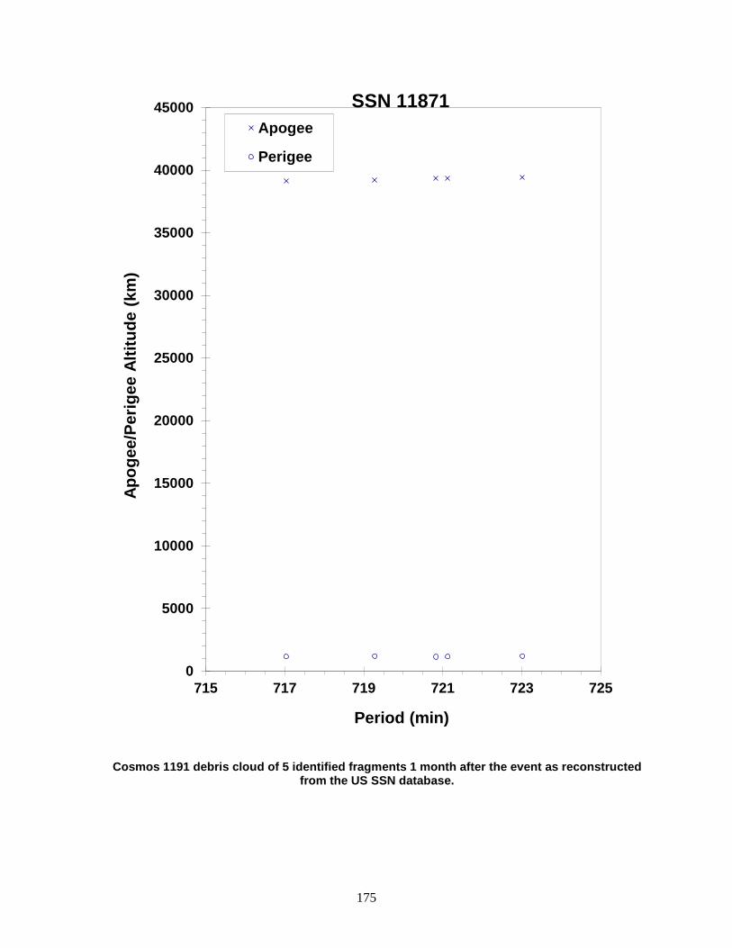
175
Cosmos 1191 debris cloud of 5 identified fragments 1 month after the event as reconstructed from the US SSN database.
0
5000
10000
15000
20000
25000
30000
35000
40000
45000
715 717 719 721 723 725
Apog
ee/P
erig
ee A
ltitu
de (k
m)
Period (min)
Apogee
Perigee
SSN 11871

176
COSMOS 1217 1980-085A 12032 SATELLITE DATA TYPE: Payload OWNER: CIS LAUNCH DATE: 24.46 Oct 1980 DRY MASS (KG): 1250 MAIN BODY: Cylinder; 1.7 m diameter by 2 m length MAJOR APPENDAGES: Solar panels ATTITUDE CONTROL: Active, 3-axis ENERGY SOURCES: On-board propellants, explosive charge EVENT DATA DATE: 12 Feb 1983 LOCATION: Unknown TIME: Unknown ASSESSED CAUSE: Deliberate ALTITUDE: Unknown PRE-EVENT ELEMENTS EPOCH: 83042.34036514 MEAN ANOMALY: 6.0502 RIGHT ASCENSION: 36.1600 MEAN MOTION: 2.00587025 INCLINATION: 65.2478 MEAN MOTION DOT/2: 0.00001154 ECCENTRICITY: 0.7021051 MEAN MOTION DOT DOT/6: 0 ARG. OF PERIGEE: 314.5975 BSTAR: 0 DEBRIS CLOUD DATA MAXIMUM ∆P: Unknown MAXIMUM ∆I: Unknown COMMENTS Cosmos 1217 was another member of the Cosmos 862-type to experience a fragmentation. REFERENCE DOCUMENT History of Soviet/Russian Satellite Fragmentation-A Joint U.S.-Russian Investigation, N. L. Johnson et al, Kaman Sciences Corporation, October 1995.

177
Insufficient data to construct a Gabbard diagram.
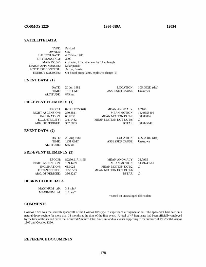
178
COSMOS 1220 1980-089A 12054 SATELLITE DATA TYPE: Payload OWNER: CIS LAUNCH DATE: 4.63 Nov 1980 DRY MASS (KG): 3000 MAIN BODY: Cylinder; 1.3 m diameter by 17 m length MAJOR APPENDAGES: Solar panels ATTITUDE CONTROL: Active, 3-axis ENERGY SOURCES: On-board propellants, explosive charge (?) EVENT DATA (1) DATE: 20 Jun 1982 LOCATION: 10S, 332E (dsc) TIME: 1818 GMT ASSESSED CAUSE: Unknown ALTITUDE: 875 km PRE-EVENT ELEMENTS (1) EPOCH: 82171.72558670 MEAN ANOMALY: 0.2166 RIGHT ASCENSION: 330.3811 MEAN MOTION: 14.49658466 INCLINATION: 65.0033 MEAN MOTION DOT/2: .00000066 ECCENTRICITY: .0219432 MEAN MOTION DOT DOT/6: .0 ARG. OF PERIGEE: 357.8883 BSTAR: .000025640 EVENT DATA (2) DATE: 25 Aug 1982 LOCATION: 65S, 238E (dsc) TIME: 1231 GMT ASSESSED CAUSE: Unknown ALTITUDE: 665 km PRE-EVENT ELEMENTS (2) EPOCH: 82230.91714195 MEAN ANOMALY: 22.7965 RIGHT ASCENSION: 159.4489 MEAN MOTION: 14.49745561 INCLINATION: 65.0025 MEAN MOTION DOT/2: .0 ECCENTRICITY: .0225583 MEAN MOTION DOT DOT/6: .0 ARG. OF PERIGEE: 336.3217 BSTAR: .0 DEBRIS CLOUD DATA MAXIMUM ∆P: 3.4 min* MAXIMUM ∆I: 1.8 deg* *Based on uncataloged debris data COMMENTS Cosmos 1220 was the seventh spacecraft of the Cosmos 699-type to experience a fragmentation. The spacecraft had been in a natural decay regime for more than 14 months at the time of the first event. A total of 47 fragments had been officially cataloged by the time of the second event that occurred 2 months later. See similar dual events happening in the summer of 1982 with Cosmos 1306 and Cosmos 1260. REFERENCE DOCUMENTS
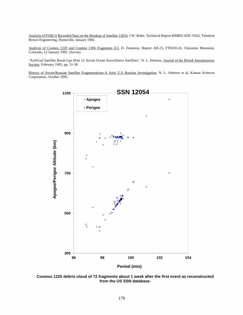
179
Analysis of PARCS Recorded Data on the Breakup of Satellite 12054, J.W. Rider, Technical Report MSB83-ADC-0162, Teledyne Brown Engineering, Huntsville, January 1983. Analysis of Cosmos 1220 and Cosmos 1306 Fragments (U), D. Fennessy, Report AH-23, FTD/OLAI, Cheyenne Mountain, Colorado, 12 January 1983 (Secret). "Artificial Satellite Break-Ups (Part 1): Soviet Ocean Surveillance Satellites", N. L. Johnson, Journal of the British Interplanetary Society, February 1983, pp. 51-58. History of Soviet/Russian Satellite Fragmentations-A Joint U.S.-Russian Investigation, N. L. Johnson et al, Kaman Sciences Corporation, October 1995.
Cosmos 1220 debris cloud of 72 fragments about 1 week after the first event as reconstructed
from the US SSN database.
300
500
700
900
1100
96 98 100 102 104
Apog
ee/P
erig
ee A
ltitu
de (k
m)
Period (min)
Apogee
Perigee
SSN 12054

180
COSMOS 1247 1981-016A 12303 SATELLITE DATA TYPE: Payload OWNER: CIS LAUNCH DATE: 19.41 Feb 1981 DRY MASS (KG): 1250 MAIN BODY: Cylinder; 1.7 m diameter by 2 m length MAJOR APPENDAGES: Solar panels ATTITUDE CONTROL: Active, 3-axis ENERGY SOURCES: On-board propellants, explosive charge EVENT DATA DATE: 20 Oct 1981 LOCATION: Unknown TIME: Unknown ASSESSED CAUSE: Deliberate ALTITUDE: Unknown PRE-EVENT ELEMENTS EPOCH: 81293.17083627 MEAN ANOMALY: 5.0298 RIGHT ASCENSION: 214.2278 MEAN MOTION: 2.00570861 INCLINATION: 62.9685 MEAN MOTION DOT/2: .0 ECCENTRICITY: .7233048 MEAN MOTION DOT DOT/6: .0 ARG. OF PERIGEE: 318.2473 BSTAR: .0 DEBRIS CLOUD DATA MAXIMUM ∆P: 2.7 min* MAXIMUM ∆I: 0.4 deg* *See comments below COMMENTS Cosmos 1247 was another spacecraft of the Cosmos 862-type to experience a fragmentation. Cosmos 1247 appears to have completed the first burn of a 2-phase maneuver sequence on the event date, followed by debris generation. The ∆P and ∆I values above are based on the post-maneuver, 711-minute orbit of 12303 rather than the pre-maneuver, 718-minute orbit cited above. REFERENCE DOCUMENT History of Soviet/Russian Satellite Fragmentations-A Joint U.S.-Russian Investigation, N. L Johnson et al, Kaman Sciences Corporation, October 1995.
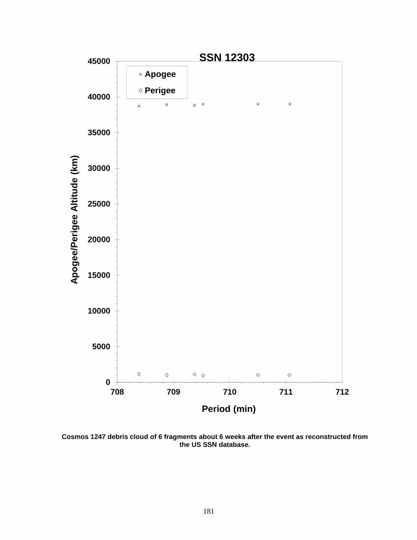
181
Cosmos 1247 debris cloud of 6 fragments about 6 weeks after the event as reconstructed from the US SSN database.
0
5000
10000
15000
20000
25000
30000
35000
40000
45000
708 709 710 711 712
Apog
ee/P
erig
ee A
ltitu
de (k
m)
Period (min)
Apogee
Perigee
SSN 12303

182
COSMOS 1260 1981-028A 12364 SATELLITE DATA TYPE: Payload OWNER: CIS LAUNCH DATE: 20.99+ Mar 1981 DRY MASS (KG): 3000 MAIN BODY: Cylinder; 1.3 m diameter by 17 m length MAJOR APPENDAGES: Solar panels ATTITUDE CONTROL: Active, 3-axis ENERGY SOURCES: On-board propellants, explosive charge (?) EVENT DATA (1) DATE: 8 May 1982 LOCATION: 40N, 62E (asc) TIME: 0444 GMT ASSESSED CAUSE: Unknown ALTITUDE: 555 km PRE-EVENT ELEMENTS (1) EPOCH: 82127.98788154 MEAN ANOMALY: 28.1726 RIGHT ASCENSION: 337.2406 MEAN MOTION: 14.88799005 INCLINATION: 65.0246 MEAN MOTION DOT/2: .00003980 ECCENTRICITY: .0214690 MEAN MOTION DOT DOT/6: .0 ARG. OF PERIGEE: 330.7493 BSTAR: .00028791 EVENT DATA (2) DATE: 10 Aug 1982 LOCATION: 51N, 238E (dsc) TIME: 2335 GMT ASSESSED CAUSE: Deliberate ALTITUDE: 750 km PRE-EVENT ELEMENTS (2) EPOCH: 82222.89259484 MEAN ANOMALY: 62.7628 RIGHT ASCENSION: 45.7388 MEAN MOTION: 14.89366232 INCLINATION: 65.0248 MEAN MOTION DOT/2: .00004369 ECCENTRICITY: .0219155 MEAN MOTION DOT DOT/6: .0 ARG. OF PERIGEE: 295.0884 BSTAR: .00030390 DEBRIS CLOUD DATA MAXIMUM ∆P: 5.2 min MAXIMUM ∆I: 1.0 deg COMMENTS Cosmos 1260 was the sixth spacecraft of the Cosmos 699-type to experience a fragmentation. The spacecraft had been in a regime of natural decay for 8 months before the first event. After the event the main remnant became satellite 13183, which then fragmented 3 months later. A total of 40 new fragments were officially cataloged prior to the second event. See also Cosmos 1220 and Cosmos 1306 for similar dual fragmentations of Cosmos 699-type spacecraft during this period.
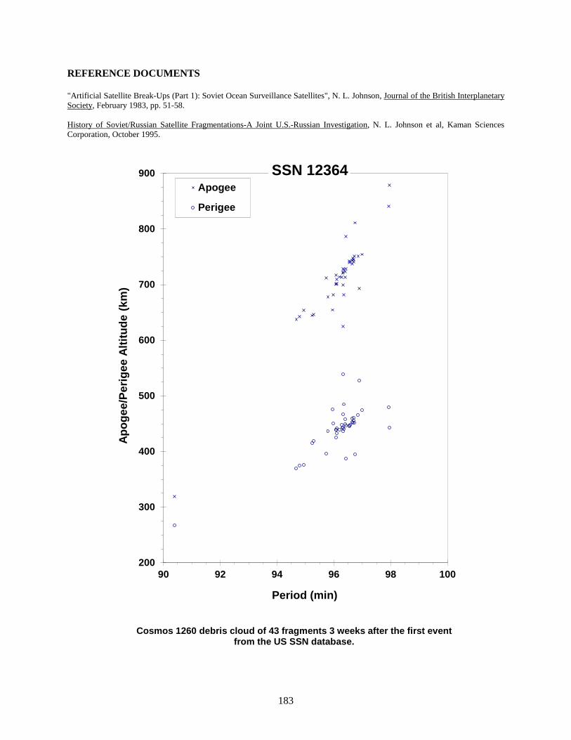
183
REFERENCE DOCUMENTS "Artificial Satellite Break-Ups (Part 1): Soviet Ocean Surveillance Satellites", N. L. Johnson, Journal of the British Interplanetary Society, February 1983, pp. 51-58. History of Soviet/Russian Satellite Fragmentations-A Joint U.S.-Russian Investigation, N. L. Johnson et al, Kaman Sciences Corporation, October 1995.
Cosmos 1260 debris cloud of 43 fragments 3 weeks after the first event from the US SSN database.
200
300
400
500
600
700
800
900
90 92 94 96 98 100
Apog
ee/P
erig
ee A
ltitu
de (k
m)
Period (min)
Apogee
Perigee
SSN 12364

184
COSMOS 1261 1981-031A 12376 SATELLITE DATA TYPE: Payload OWNER: CIS LAUNCH DATE: 31.40 Mar 1981 DRY MASS (KG): 1250 MAIN BODY: Cylinder; 1.7 m diameter by 2 m length MAJOR APPENDAGES: Solar panels ATTITUDE CONTROL: Active, 3-axis ENERGY SOURCES: On-board propellants, explosive charge EVENT DATA DATE: Apr-May 1981 LOCATION: Unknown TIME: Unknown ASSESSED CAUSE: Deliberate ALTITUDE: Unknown PRE-EVENT ELEMENTS EPOCH: 81095.90157023 MEAN ANOMALY: 4.6715 RIGHT ASCENSION: 282.6240 MEAN MOTION: 2.00494188 INCLINATION: 63.0386 MEAN MOTION DOT/2: .0 ECCENTRICITY: .7369210 MEAN MOTION DOT DOT/6: .0 ARG. OF PERIGEE: 316.4347 BSTAR: .0 DEBRIS CLOUD DATA MAXIMUM ∆P: 2.3 min* MAXIMUM ∆I: 0.3 deg* *Based on uncataloged debris data COMMENTS Cosmos 1261 was another spacecraft of the Cosmos 862-type to experience a fragmentation. The spacecraft attempted to maneuver from its transfer orbit to an operational orbit 3 days after launch. The maneuver appears to have been unsuccessful, and the spacecraft never became groundtrack-stabilized. Some debris appeared immediately after the maneuver, while additional debris were discovered in mid-May. More than one event may have occurred. The element set above is the first available after the unsuccessful maneuver. REFERENCE DOCUMENT History of Soviet/Russian Satellite Fragmentations-A Joint U.S.-Russian Investigation, N. L. Johnson et al, Kaman Sciences Corporation, October 1995.
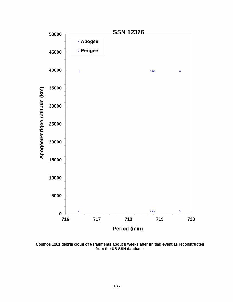
185
Cosmos 1261 debris cloud of 6 fragments about 8 weeks after (initial) event as reconstructed from the US SSN database.
0
5000
10000
15000
20000
25000
30000
35000
40000
45000
50000
716 717 718 719 720
Apog
ee/P
erig
ee A
ltitu
de (k
m)
Period (min)
Apogee
Perigee
SSN 12376
186
COSMOS 1275 1981-053A 12504 SATELLITE DATA TYPE: Payload OWNER: CIS LAUNCH DATE: 4.66 Jun 1981 DRY MASS (KG): 800 MAIN BODY: Cylinder; 2.4 m diameter by 2 m length MAJOR APPENDAGES: Gravity-gradient boom ATTITUDE CONTROL: Gravity gradient ENERGY SOURCES: Unknown EVENT DATA DATE: 24 Jul 1981 LOCATION: 68N, 197E (asc) TIME: 2351 GMT ASSESSED CAUSE: Battery ALTITUDE: 980 km PRE-EVENT ELEMENTS EPOCH: 81205.39693092 MEAN ANOMALY: 221.3567 RIGHT ASCENSION: 119.8245 MEAN MOTION: 13.73455672 INCLINATION: 82.9633 MEAN MOTION DOT/2: .000000580 ECCENTRICITY: .0036415 MEAN MOTION DOT DOT/6: .0 ARG. OF PERIGEE: 139.0334 BSTAR: .00004538900 DEBRIS CLOUD DATA MAXIMUM ∆P: 4.9 min MAXIMUM ∆I: 0.4 deg COMMENTS Cosmos 1275 is the only member of its class, Parus, to explosively fragment; the Cosmos 1934 event was a collision with tracked, mission-related debris. The satellite was only 50 days old at the time of the event. During the February 1992 Space Debris Conference in Moscow, Russian analysts discussed independent studies about the probable cause of the breakup. Later, the official Russian assessment asserted that a battery malfunction was the likely culprit. REFERENCE DOCUMENTS The Fragmentations of USSR Satellites 11729 and 12504 (U), J.R. Gabbard and P.M. Landry, Technical Memorandum 82-S-03, DCS/Plans, Hdqtrs NORAD/ADCOM, Colorado Springs, August 1982 (Secret). Determining the Cause of a Satellite Breakup: A Case Study of the Kosmos 1275 Breakup, D.S. McKnight, IAA-87-573, 38th Congress of the International Astronautical Federation, Brighton, England, October 1987. History of Soviet/Russian Satellite Fragmentations-A Joint U.S.-Russian Investigation, N. L. Johnson et al, Kaman Sciences Corporation, October 1995.

187
Cosmos 1275 debris cloud of 136 identified fragments 1 week after the event as reconstructed from the US SSN database.
600
800
1000
1200
1400
100 102 104 106 108 110
Apog
ee/P
erig
ee A
ltitu
de (k
m)
Period (min)
Apogee
Perigee
SSN 12504
188
COSMOS 1278 1981-058A 12547 SATELLITE DATA TYPE: Payload OWNER: CIS LAUNCH DATE: 19.81 Jun 1981 DRY MASS (KG): 1250 MAIN BODY: Cylinder; 1.7 m diameter by 2 m length MAJOR APPENDAGES: Solar panels ATTITUDE CONTROL: Active, 3-axis ENERGY SOURCES: On-board propellants, explosive charge EVENT DATA DATE: Early Dec 1986 LOCATION: Unknown TIME: Unknown ASSESSED CAUSE: Deliberate ALTITUDE: Unknown PRE-EVENT ELEMENTS EPOCH: 86334.22199701 MEAN ANOMALY: 12.7886 RIGHT ASCENSION: 288.0814 MEAN MOTION: 2.00618298 INCLINATION: 67.1073 MEAN MOTION DOT/2: .0 ECCENTRICITY: .6594262 MEAN MOTION DOT DOT/6: .0 ARG. OF PERIGEE: 291.9890 BSTAR: .0 DEBRIS CLOUD DATA MAXIMUM ∆P: 0.1 min MAXIMUM ∆I: 0.0 deg COMMENTS Cosmos 1278 was another spacecraft of the Cosmos 862-type to experience a fragmentation. Spacecraft had apparently been inactive since early 1984. Additional fragments may exist, but surveillance for small objects in this high eccentricity orbit is difficult. REFERENCE DOCUMENT History of Soviet/Russian Satellite Fragmentations-A Joint U.S.-Russian Investigation, N. L. Johnson et al, Kaman Sciences Corporation, October 1995.
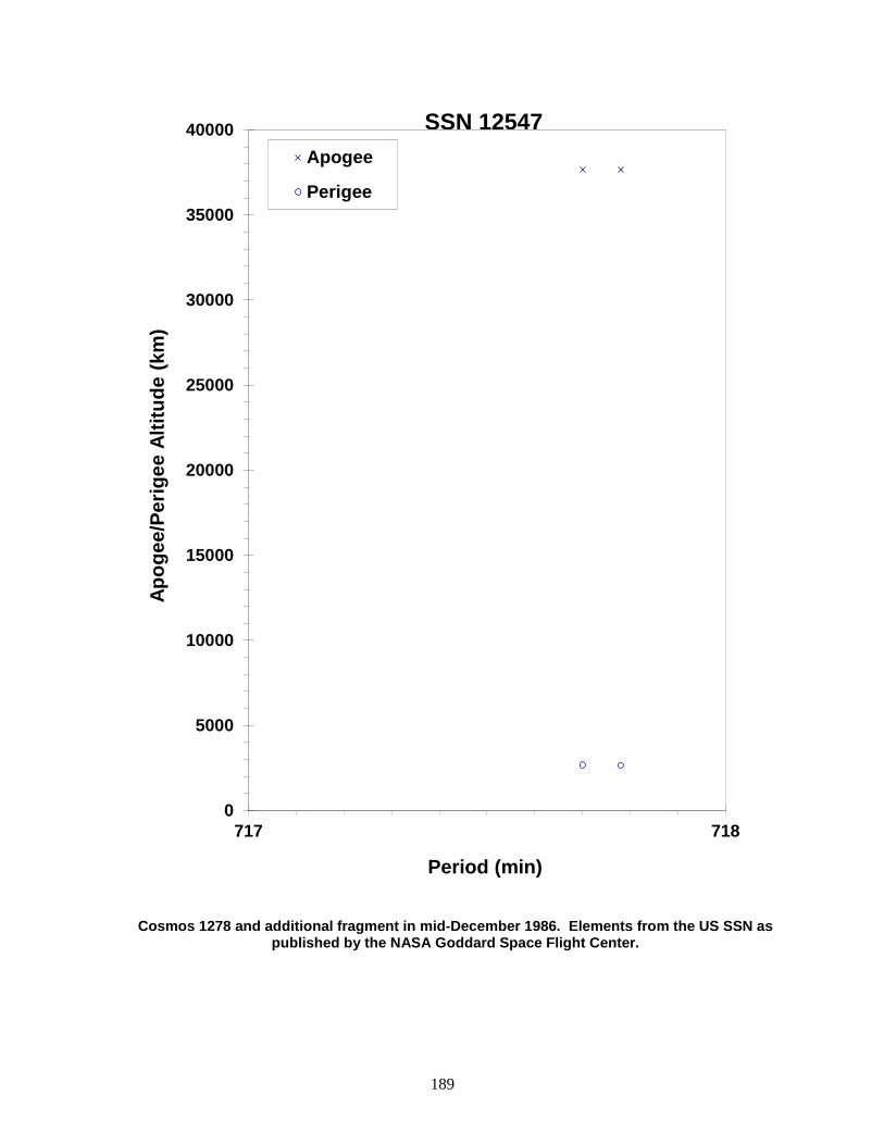
189
Cosmos 1278 and additional fragment in mid-December 1986. Elements from the US SSN as published by the NASA Goddard Space Flight Center.
0
5000
10000
15000
20000
25000
30000
35000
40000
717 718
Apog
ee/P
erig
ee A
ltitu
de (k
m)
Period (min)
Apogee
Perigee
SSN 12547
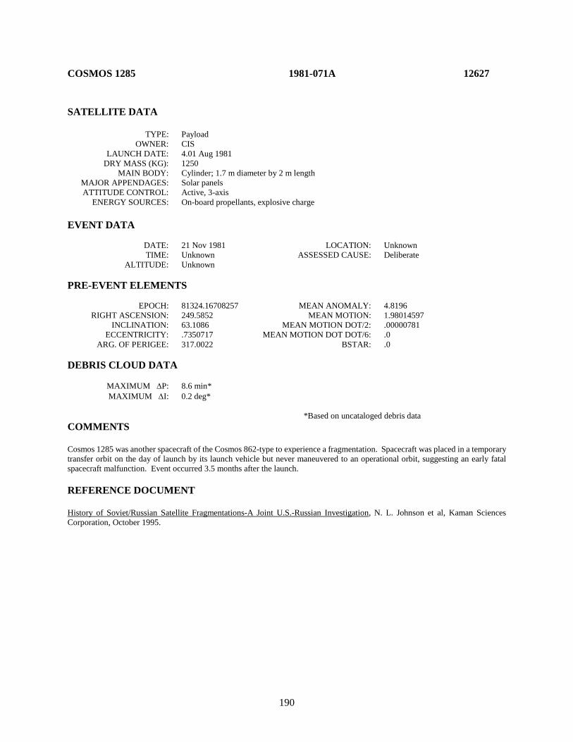
190
COSMOS 1285 1981-071A 12627 SATELLITE DATA TYPE: Payload OWNER: CIS LAUNCH DATE: 4.01 Aug 1981 DRY MASS (KG): 1250 MAIN BODY: Cylinder; 1.7 m diameter by 2 m length MAJOR APPENDAGES: Solar panels ATTITUDE CONTROL: Active, 3-axis ENERGY SOURCES: On-board propellants, explosive charge EVENT DATA DATE: 21 Nov 1981 LOCATION: Unknown TIME: Unknown ASSESSED CAUSE: Deliberate ALTITUDE: Unknown PRE-EVENT ELEMENTS EPOCH: 81324.16708257 MEAN ANOMALY: 4.8196 RIGHT ASCENSION: 249.5852 MEAN MOTION: 1.98014597 INCLINATION: 63.1086 MEAN MOTION DOT/2: .00000781 ECCENTRICITY: .7350717 MEAN MOTION DOT DOT/6: .0 ARG. OF PERIGEE: 317.0022 BSTAR: .0 DEBRIS CLOUD DATA MAXIMUM ∆P: 8.6 min* MAXIMUM ∆I: 0.2 deg* *Based on uncataloged debris data COMMENTS Cosmos 1285 was another spacecraft of the Cosmos 862-type to experience a fragmentation. Spacecraft was placed in a temporary transfer orbit on the day of launch by its launch vehicle but never maneuvered to an operational orbit, suggesting an early fatal spacecraft malfunction. Event occurred 3.5 months after the launch. REFERENCE DOCUMENT History of Soviet/Russian Satellite Fragmentations-A Joint U.S.-Russian Investigation, N. L. Johnson et al, Kaman Sciences Corporation, October 1995.
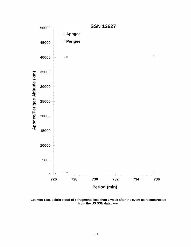
191
Cosmos 1285 debris cloud of 5 fragments less than 1 week after the event as reconstructed from the US SSN database.
0
5000
10000
15000
20000
25000
30000
35000
40000
45000
50000
726 728 730 732 734 736
Apog
ee/P
erig
ee A
ltitu
de (k
m)
Period (min)
Apogee
Perigee
SSN 12627

192
COSMOS 1286 1981-072A 12631 SATELLITE DATA TYPE: Payload OWNER: CIS LAUNCH DATE: 4.35 Aug 1981 DRY MASS (KG): 3000 MAIN BODY: Cylinder; 1.3 m diameter by 17 m length MAJOR APPENDAGES: Solar panels ATTITUDE CONTROL: Active, 3-axis ENERGY SOURCES: On-board propellants, explosive charge (?) EVENT DATA DATE: 29 Sep 1982 LOCATION: 51N, 80E (asc) TIME: 0520 GMT ASSESSED CAUSE: Unknown ALTITUDE: 325 km PRE-EVENT ELEMENTS EPOCH: 82272.21193719 MEAN ANOMALY: 92.4681 RIGHT ASCENSION: 132.9736 MEAN MOTION: 15.86141247 INCLINATION: 65.0071 MEAN MOTION DOT/2: .00400345 ECCENTRICITY: .0017215 MEAN MOTION DOT DOT/6: .0 ARG. OF PERIGEE: 267.4145 BSTAR: .0015199 DEBRIS CLOUD DATA MAXIMUM ∆P: 0.9 min* MAXIMUM ∆I: 0.2 deg* *Based on uncataloged debris data COMMENTS Cosmos 1286 was the ninth spacecraft of the Cosmos 699-type to experience a fragmentation. The spacecraft had been in a regime of natural decay for more than 6 months at the time of the event. The low altitude and high drag conditions made determination of the precise breakup time uncertain. The breakup or a precursor event may have occurred earlier on 29 September 1982. Most fragments decayed before being officially cataloged. REFERENCE DOCUMENTS "Artificial Satellite Break-Ups (Part 1): Soviet Ocean Surveillance Satellites", N. L. Johnson, Journal of the British Interplanetary Society, February 1983, pp. 51-58. History of Soviet/Russian Satellite Fragmentation-A Joint U.S.-Russian Investigation, N. L. Johnson et al, Kaman Sciences Corporation, October 1995.
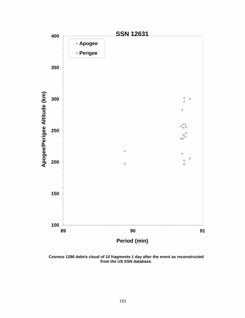
193
Cosmos 1286 debris cloud of 10 fragments 1 day after the event as reconstructed from the US SSN database.
100
150
200
250
300
350
400
89 90 91
Apog
ee/P
erig
ee A
ltitu
de (k
m)
Period (min)
Apogee
Perigee
SSN 12631
194
COSMOS 1305 R/B 1981-088F 12827 SATELLITE DATA TYPE: Molniya Final Stage OWNER: CIS LAUNCH DATE: 11.36 Sep 1981 DRY MASS (KG): 1100 MAIN BODY: Cylinder; 2.7 m diameter by 3 m length MAJOR APPENDAGES: None ATTITUDE CONTROL: Active, 3-axis ENERGY SOURCES: On-board propellants EVENT DATA DATE: 11 Sep 1981 LOCATION: Unknown TIME: Unknown ASSESSED CAUSE: Propulsion ALTITUDE: Unknown POST-EVENT ELEMENTS EPOCH: 81258.60717998 MEAN ANOMALY: 26.9249 RIGHT ASCENSION: 68.6245 MEAN MOTION: 5.48678032 INCLINATION: 62.8166 MEAN MOTION DOT/2: .0 ECCENTRICITY: .4855644 MEAN MOTION DOT DOT/6: .0 ARG. OF PERIGEE: 286.6972 BSTAR: .0 DEBRIS CLOUD DATA MAXIMUM ∆P: Unknown MAXIMUM ∆I: Unknown COMMENTS Cosmos 1305 R/B malfunctioned about 1 hour after launch during a maneuver from a LEO parking orbit to a Molniya-type orbit. The maneuver was initiated at approximately 0937 GMT near 58S, 245E (asc) at an altitude of 600 km. Apogee was raised to less than 14,000 km. Debris tracking after the event was limited, preventing an accurate assessment of magnitude of the event. First debris officially cataloged in June 1983. Debris generation is assumed to have occurred during or immediately after the unsuccessful maneuver. The element set above is for the rocket body after burn termination. REFERENCE DOCUMENT History of Soviet/Russian Satellite Fragmentations-A Joint U.S.-Russian Investigation, N. L. Johnson et al, Kaman Sciences Corporation, October 1995.

195
Cosmos 1305 R/B debris cloud of 7 fragments about 2 years after the event as reconstructed from the US SSN database.
0
3000
6000
9000
12000
15000
220 230 240 250 260 270
Apog
ee/P
erig
ee A
ltitu
de (k
m)
Period (min)
Apogee
Perigee
SSN 12827
196
COSMOS 1306 1981-089A 12828 SATELLITE DATA TYPE: Payload OWNER: CIS LAUNCH DATE: 14.85 Sep 1981 DRY MASS (KG): 3000 MAIN BODY: Cylinder; 1.3 m diameter by 17 m length MAJOR APPENDAGES: Solar panels ATTITUDE CONTROL: Active, 3-axis ENERGY SOURCES: On-board propellants, explosive charge (?) EVENT DATA (1) DATE: 12 Jul 1982 LOCATION: 65S, 40E (asc) TIME: 2325 GMT ASSESSED CAUSE: Unknown ALTITUDE: 380 km PRE-EVENT ELEMENTS (1) EPOCH: 82193.22052182 MEAN ANOMALY: 72.7640 RIGHT ASCENSION: 43.8843 MEAN MOTION: 15.58171668 INCLINATION: 64.9399 MEAN MOTION DOT/2: .00042116 ECCENTRICITY: .0019953 MEAN MOTION DOT DOT/6: .0 ARG. OF PERIGEE: 287.2390 BSTAR: .00055055 EVENT DATA (2) DATE: 18 Sep 1982 LOCATION: 32N, 293E (asc) TIME: 1702 GMT ASSESSED CAUSE: Unknown ALTITUDE: 370 km PRE-EVENT ELEMENTS (2) EPOCH: 82260.17037940 MEAN ANOMALY: 44.8033 RIGHT ASCENSION: 173.7764 MEAN MOTION: 15.65882738 INCLINATION: 64.9408 MEAN MOTION DOT/2: .00076164 ECCENTRICITY: .0002181 MEAN MOTION DOT DOT/6: .0 ARG. OF PERIGEE: 315.2578 BSTAR: .00073994 DEBRIS CLOUD DATA MAXIMUM ∆P: 2.1 min* MAXIMUM ∆I: 0.2 deg *Based on uncataloged debris data COMMENTS Cosmos 1306 was the eighth spacecraft of the Cosmos 699-type to experience a fragmentation. The first event occurred 5 months after the spacecraft had entered a regime of natural decay. After the event the main remnant was tagged as satellite 13369, while a piece of debris tagged as 12828 decayed on 16 July 1982. Only 5 new fragments were officially cataloged prior to the second event when satellite 13369 experienced a fragmentation. Three long-lived fragments cataloged with 1981-89 (13393, 13404, and 14837) were actually part of the breakup of 1980-89, another Cosmos 699-type satellite. Most Cosmos 1306 debris reentered quickly and elements were developed for only a few fragments.
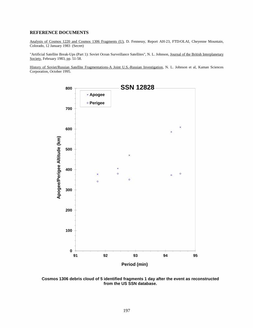
197
REFERENCE DOCUMENTS Analysis of Cosmos 1220 and Cosmos 1306 Fragments (U), D. Fennessy, Report AH-23, FTD/OLAI, Cheyenne Mountain, Colorado, 12 January 1983 (Secret) "Artificial Satellite Break-Ups (Part 1): Soviet Ocean Surveillance Satellites", N. L. Johnson, Journal of the British Interplanetary Society, February 1983, pp. 51-58. History of Soviet/Russian Satellite Fragmentations-A Joint U.S.-Russian Investigation, N. L. Johnson et al, Kaman Sciences Corporation, October 1995.
Cosmos 1306 debris cloud of 5 identified fragments 1 day after the event as reconstructed from the US SSN database.
0
100
200
300
400
500
600
700
800
91 92 93 94 95
Apog
ee/P
erig
ee A
ltitu
de (k
m)
Period (min)
Apogee
Perigee
SSN 12828
198
COSMOS 1317 1981-108A 12933 SATELLITE DATA TYPE: Payload OWNER: CIS LAUNCH DATE: 31.95 Oct 1981 DRY MASS (KG): 1250 MAIN BODY: Cylinder; 1.7 m diameter by 2 m length MAJOR APPENDAGES: Solar panels ATTITUDE CONTROL: Active, 3-axis ENERGY SOURCES: On-board propellants, explosive EVENT DATA DATE: 25-28 Jan 1984 LOCATION: Unknown TIME: Unknown ASSESSED CAUSE: Deliberate ALTITUDE: Unknown PRE-EVENT ELEMENTS EPOCH: 84024.46309667 MEAN ANOMALY: 4.4900 RIGHT ASCENSION: 219.5352 MEAN MOTION: 2.00535027 INCLINATION: 62.8286 MEAN MOTION DOT/2: .0 ECCENTRICITY: .7103977 MEAN MOTION DOT DOT/6: .0 ARG. OF PERIGEE: 324.1891 BSTAR: .0 DEBRIS CLOUD DATA MAXIMUM ∆P: 1.8 min MAXIMUM ∆I: 0.3 deg COMMENTS Cosmos 1317 was another spacecraft of the Cosmos 862-type to experience a fragmentation REFERENCE DOCUMENT History of Soviet/Russian Satellite Fragmentations-A Joint U.S.-Russian Investigation, N. L. Johnson et al, Kaman Sciences Corporation, October 1995.
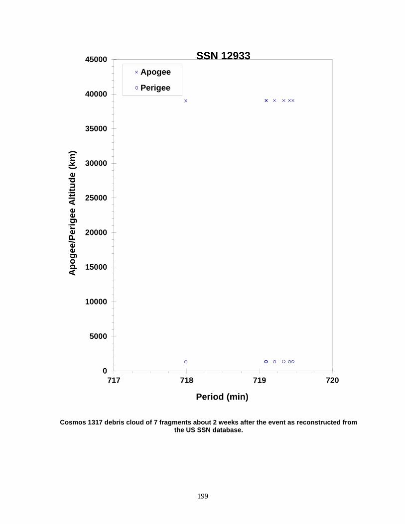
199
Cosmos 1317 debris cloud of 7 fragments about 2 weeks after the event as reconstructed from the US SSN database.
0
5000
10000
15000
20000
25000
30000
35000
40000
45000
717 718 719 720
Apog
ee/P
erig
ee A
ltitu
de (k
m)
Period (min)
Apogee
Perigee
SSN 12933
200
COSMOS 1348 1982-029A 13124 SATELLITE DATA TYPE: Payload OWNER: CIS LAUNCH DATE: 7.57 April 1982 DRY MASS (KG): 1250 MAIN BODY: Cylinder; 1.7 m diameter by 2 m length MAJOR APPENDAGES: Solar panels ATTITUDE CONTROL: Active, 3-axis ENERGY SOURCES: On-board propellants, explosive device EVENT DATA DATE: 2 September 1984 LOCATION: 39.5N, 121.3E (asc) TIME: 0957 GMT ASSESSED CAUSE: Deliberate ALTITUDE: 5020 km PRE-EVENT ELEMENTS EPOCH: 84246.40302854 MEAN ANOMALY: 3.8405 RIGHT ASCENSION: 227.2447 MEAN MOTION: 2.00449045 INCLINATION: 62.8163 MEAN MOTION DOT/2: .00000970 ECCENTRICITY: .7154927 MEAN MOTION DOT DOT/6: .0 ARG. OF PERIGEE: 326.7879 BSTAR: .0 DEBRIS CLOUD DATA MAXIMUM ∆P: 25.5 min MAXIMUM ∆I: 7.3 deg COMMENTS Cosmos 1348 was a member of the Cosmos 862 class of operational satellites in highly elliptical, semi-synchronous orbits that experienced a total of 16 fragmentations during the period 1977-1986. Due to the nature of these orbits, which result in high altitudes over the Northern Hemisphere where most surveillance sensors are located, debris detection and tracking is extremely difficult. Only the largest fragments can be seen. Cosmos 862 class spacecraft were equipped with self-destruct packages in the event that spacecraft control was lost; this was the cause of breakups until the explosives were removed after Cosmos 1481. Podvig reported an estimate end of life for Cosmos 1348 as 22 July 1984. If correct, this could imply a breakup mechanism different that other members of the Cosmos 862 class. An examination of the mean motion history of Cosmos 1348 indicated, however, that it was under active control until the event date of 2 September 1984, implying that the cause attributed to the fragmentation of other class members was similarly responsible for this spacecraft’s fragmentation. REFERENCE DOCUMENT History of Soviet/Russian Satellite Fragmentations-A Joint U.S.-Russian Investigation, N. L. Johnson et al., Kaman Sciences Corporation, October 1995. Podvig, P., “History and the Current Status of the Russian Early-Warning System”. Science and Global Security 10 (2002): 21-60.
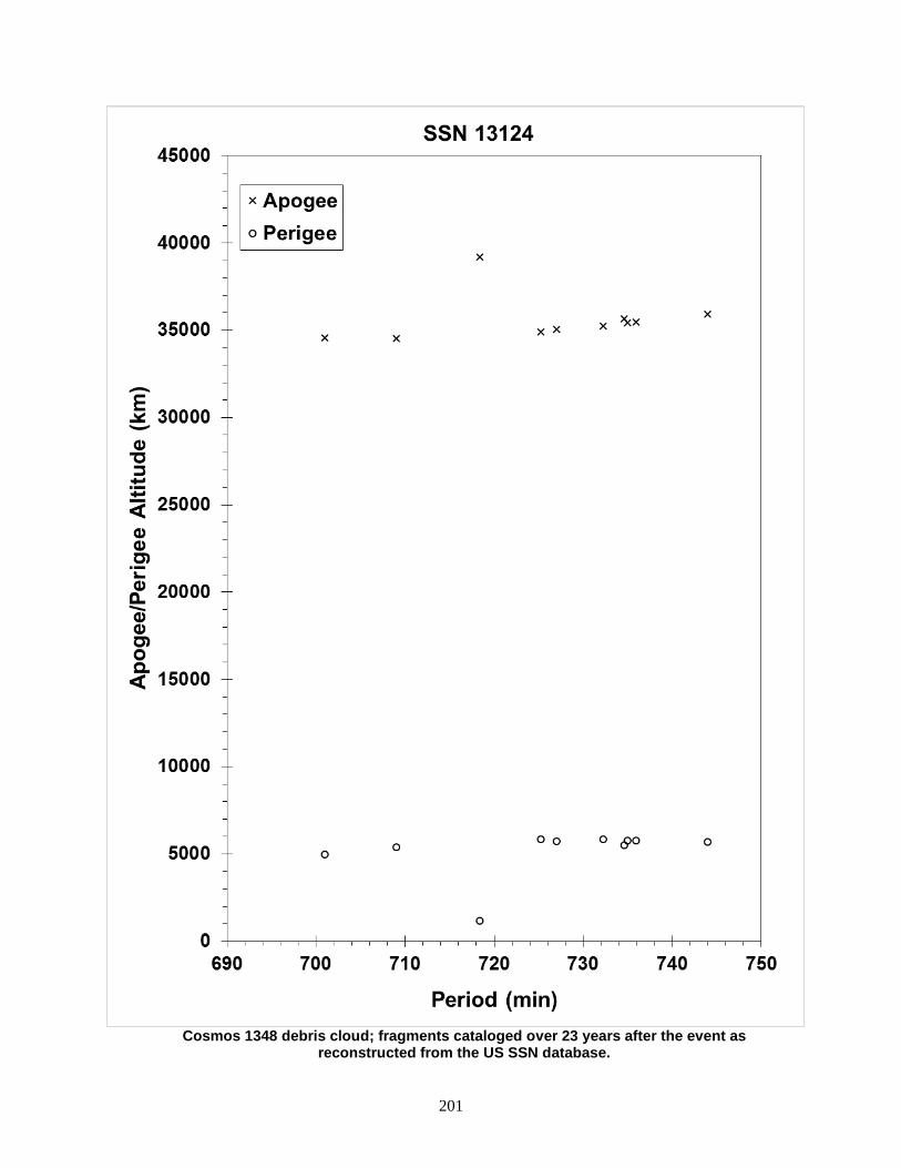
201
Cosmos 1348 debris cloud; fragments cataloged over 23 years after the event as
reconstructed from the US SSN database.
202
COSMOS 1355 1982-038A 13150 SATELLITE DATA TYPE: Payload OWNER: CIS LAUNCH DATE: 29.41 Apr 1982 DRY MASS (KG): 3000 MAIN BODY: Cylinder; 1.3 m diameter by 17 m length MAJOR APPENDAGES: Solar panels ATTITUDE CONTROL: Active, 3-axis ENERGY SOURCES: On-board propellants, explosive charge (?) EVENT DATA (1) DATE: 8 Aug 1983 LOCATION: 32S, 310E (asc) TIME: 2331 GMT ASSESSED CAUSE: Unknown ALTITUDE: 365 km PRE-EVENT ELEMENTS (1) EPOCH: 83220.21851552 MEAN ANOMALY: 66.8795 RIGHT ASCENSION: 279.4096 MEAN MOTION: 15.63233551 INCLINATION: 65.0504 MEAN MOTION DOT/2: .00048258 ECCENTRICITY: .0024043 MEAN MOTION DOT DOT/6: .0 ARG. OF PERIGEE: 292.8515 BSTAR: .00051620 EVENT DATA (2) DATE: 1 Feb 1984 LOCATION: 4S, 200E (asc) TIME: 0322 GMT ASSESSED CAUSE: Unknown ALTITUDE: 320 km PRE-EVENT ELEMENTS (2) EPOCH: 84031.38369465 MEAN ANOMALY: 81.7159 RIGHT ASCENSION: 25.3553 MEAN MOTION: 15.84652631 INCLINATION: 65.0404 MEAN MOTION DOT/2: .00119378 ECCENTRICITY: .0017572 MEAN MOTION DOT DOT/6: .0 ARG. OF PERIGEE: 278.1110 BSTAR: .00050318 EVENT DATA (3) DATE: 20 Feb 1984 LOCATION: Unknown TIME: Before 0340 GMT ASSESSED CAUSE: Unknown ALTITUDE: Unknown PRE-EVENT ELEMENTS (3) EPOCH: 84050.69015256 MEAN ANOMALY: 105.8772 RIGHT ASCENSION: 316.3115 MEAN MOTION: 15.97914042 INCLINATION: 65.0338 MEAN MOTION DOT/2: .00430956 ECCENTRICITY: .0014134 MEAN MOTION DOT DOT/6: .000083799 ARG. OF PERIGEE: 254.0517 BSTAR: .00093344 DEBRIS CLOUD DATA MAXIMUM ∆P: 36.8 min* MAXIMUM ∆I: 2.3 deg* *Based on uncataloged debris data (Event 1) COMMENTS Cosmos 1355 was the tenth spacecraft of the Cosmos 699-type to experience a fragmentation. The spacecraft had been in a regime of natural decay for 6 months prior to the first event. Twenty-one fragments were cataloged following the first event, and the main body became satellite 14275. This object spawned at least seven more fragments on 1 February. The parent was then retagged to the original 13150 satellite number. The third event resulted in the development of 13 new fragment element sets, but none were cataloged and the low altitude prevented an estimate of a precise breakup location.
REFERENCE DOCUMENTS
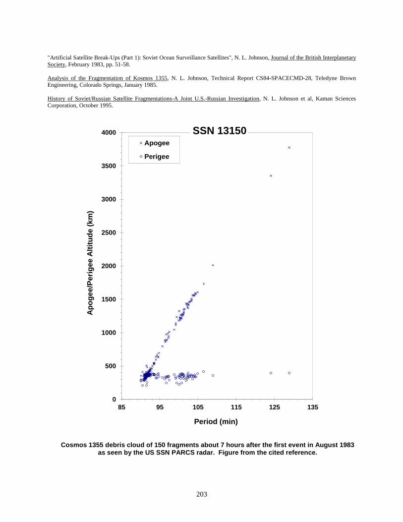
203
"Artificial Satellite Break-Ups (Part 1): Soviet Ocean Surveillance Satellites", N. L. Johnson, Journal of the British Interplanetary Society, February 1983, pp. 51-58. Analysis of the Fragmentation of Kosmos 1355, N. L. Johnson, Technical Report CS84-SPACECMD-28, Teledyne Brown Engineering, Colorado Springs, January 1985. History of Soviet/Russian Satellite Fragmentations-A Joint U.S.-Russian Investigation, N. L. Johnson et al, Kaman Sciences Corporation, October 1995.
Cosmos 1355 debris cloud of 150 fragments about 7 hours after the first event in August 1983 as seen by the US SSN PARCS radar. Figure from the cited reference.
0
500
1000
1500
2000
2500
3000
3500
4000
85 95 105 115 125 135
Apo
gee/
Perig
ee A
ltitu
de (k
m)
Period (min)
Apogee
Perigee
SSN 13150

204
COSMOS 1375 1982-055A 13259 SATELLITE DATA TYPE: Payload OWNER: CIS LAUNCH DATE: 6.72 Jun 1982 DRY MASS (KG): 650 MAIN BODY: Polyhedron; 1.4 m by 1.4 m MAJOR APPENDAGES: Solar panels, gravity-gradient boom (?) ATTITUDE CONTROL: Gravity gradient (?) ENERGY SOURCES: Battery EVENT DATA DATE: 21 Oct 1985 LOCATION: 66N, 351E (asc) TIME: 0353 GMT ASSESSED CAUSE: Battery ALTITUDE: 995 km PRE-EVENT ELEMENTS EPOCH: 85293.85195210 MEAN ANOMALY: 333.5602 RIGHT ASCENSION: 350.2805 MEAN MOTION: 13.71079597 INCLINATION: 65.8390 MEAN MOTION DOT/2: .00000158 ECCENTRICITY: .0005355 MEAN MOTION DOT DOT/6: .0 ARG. OF PERIGEE: 26.5667 BSTAR: .00023894 DEBRIS CLOUD DATA MAXIMUM ∆P: 2.3 min* MAXIMUM ∆I: 0.1 deg* *Based on uncataloged debris data COMMENTS Cosmos 1375 was the third spacecraft of the Cosmos 839-type to experience a fragmentation. Although these satellites are used in conjunction with the Cosmos 249-type spacecraft that are deliberately fragmented, the cause of Cosmos 839-type events appears to be unrelated. In the case of Cosmos 1375, 40 months elapsed since its test with a Cosmos 249-type spacecraft. REFERENCE DOCUMENTS "Artificial Satellite Break-Ups (Part 2): Soviet Anti-Satellite Program", N.L. Johnson, Journal of the British Interplanetary Society, August 1983, pp. 357-362. Analysis of the Kosmos 1375 Fragmentation, J. M. Koskella and R. L. Kling, Technical Report CS86-USASDC-0006, Teledyne Brown Engineering, Colorado Springs, March 1986. History of Soviet/Russian Satellite Fragmentations-A Joint U.S.-Russian Investigation, N. L. Johnson et al, Kaman Sciences Corporation, October 1995.

205
Cosmos 1375 debris cloud of 68 fragments seen a few hours after the event by the US SSN PARCS radar.
700
800
900
1000
1100
1200
1300
103 104 105 106 107 108
Apog
ee/P
erig
ee A
ltitu
de (k
m)
Period (min)
Apogee
Perigee
SSN 13259

206
COSMOS 1405 1982-088A 13508 SATELLITE DATA TYPE: Payload OWNER: CIS LAUNCH DATE: 4.74 Sep 1982 DRY MASS (KG): 3000 MAIN BODY: Cylinder; 1.3 m diameter by 17 m length MAJOR APPENDAGES: Solar panels ATTITUDE CONTROL: Active, 3-axis ENERGY SOURCES: On-board propellants, explosive charge (?) EVENT DATA DATE: 20 Dec 1983 LOCATION: 25S, 45E (dsc) TIME: 1215 GMT ASSESSED CAUSE: Unknown ALTITUDE: 330 km PRE-EVENT ELEMENTS EPOCH: 83354.22079767 MEAN ANOMALY: 42.0375 RIGHT ASCENSION: 126.1259 MEAN MOTION: 15.81899265 INCLINATION: 65.0055 MEAN MOTION DOT/2: .00186341 ECCENTRICITY: .0020774 MEAN MOTION DOT DOT/6: .0 ARG. OF PERIGEE: 318.0927 BSTAR: .00088277 DEBRIS CLOUD DATA MAXIMUM ∆P: 7.3 min* MAXIMUM ∆I: 2.0 deg* *Based on uncataloged debris data COMMENTS Cosmos 1405 was the eleventh spacecraft of the Cosmos 699-type to experience a fragmentation. Spacecraft had been in natural decay for 12 months prior to the event. Most debris reentered before being officially cataloged. REFERENCE DOCUMENTS "Artificial Satellite Break-Ups (Part 1): Soviet Ocean Surveillance Satellites", N. L. Johnson, Journal of the British Interplanetary Society, February 1983, pp. 51-58. Separation of Objects from Cosmos 1405, F.T. Lipp, NAVSPASUR Technical Note 1-84, Naval Space Surveillance System, Dahlgren, 2 April 1984. Analysis of the Fragmentation of Kosmos 1405, N.L. Johnson, Technical Report CS84-SPACECMD-10, Teledyne Brown Engineering, Colorado Springs, September 1984. History of Soviet/Russian Satellite Fragmentations-A Joint U.S.-Russian Investigation, N. L. Johnson et al, Kaman Sciences Corporation, October 1995.
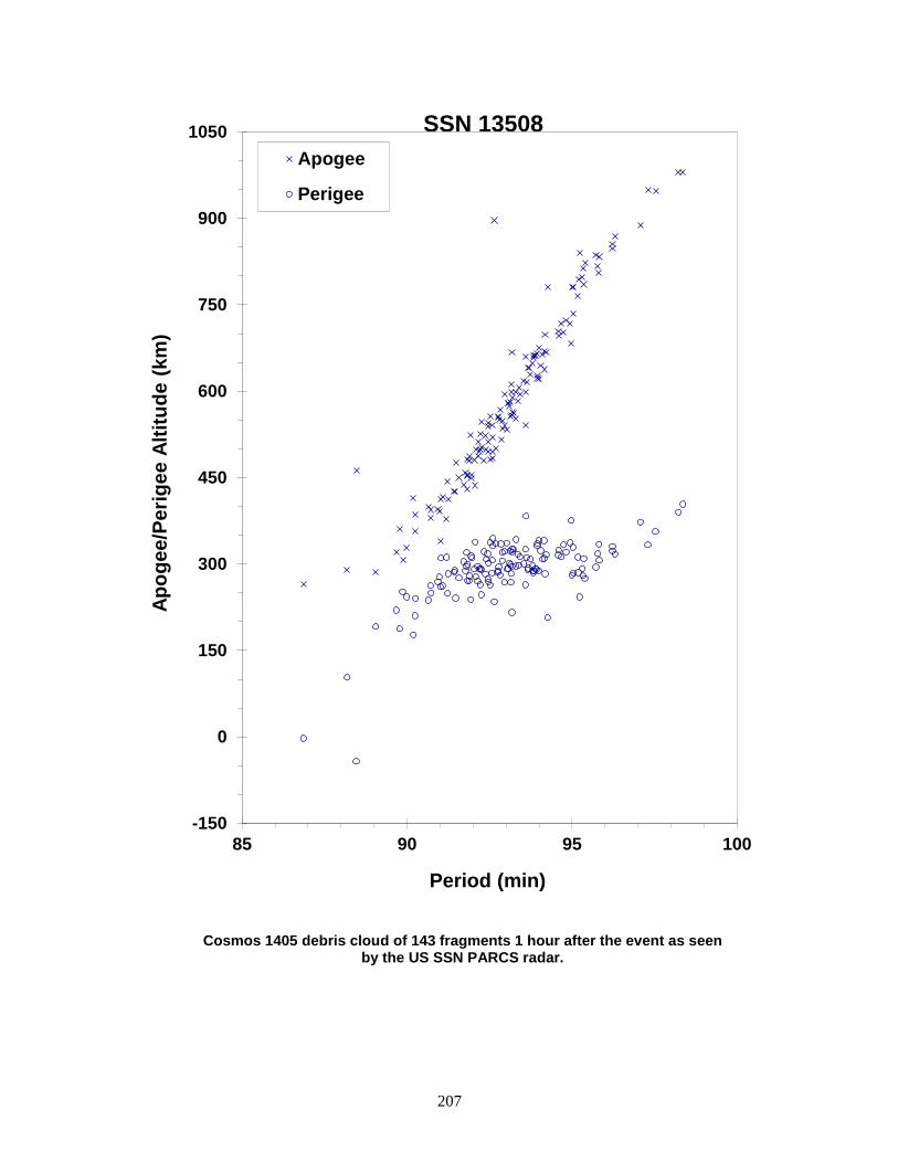
207
Cosmos 1405 debris cloud of 143 fragments 1 hour after the event as seen by the US SSN PARCS radar.
-150
0
150
300
450
600
750
900
1050
85 90 95 100
Apog
ee/P
erig
ee A
ltitu
de (k
m)
Period (min)
Apogee
Perigee
SSN 13508

208
COSMOS 1423 R/B 1982-115E 13696 SATELLITE DATA TYPE: Molniya Final Stage OWNER: CIS LAUNCH DATE: 8.58 Dec 1982 DRY MASS (KG): 1100 MAIN BODY: Cylinder; 2.7 m diameter by 3 m length MAJOR APPENDAGES: None ATTITUDE CONTROL: Active, 3-axis ENERGY SOURCES: On-board propellants EVENT DATA DATE: 8 Dec 1982 LOCATION: 62S, 302E (asc) TIME: 1448 GMT ASSESSED CAUSE: Propulsion ALTITUDE: 400 km PRE-EVENT ELEMENTS EPOCH: 82342.56790507 MEAN ANOMALY: 305.2204 RIGHT ASCENSION: 316.3789 MEAN MOTION: 15.79849844 INCLINATION: 62.9496 MEAN MOTION DOT/2: .0 ECCENTRICITY: .0143321 MEAN MOTION DOT DOT/6: .0 ARG. OF PERIGEE: 56.2493 BSTAR: .0 DEBRIS CLOUD DATA MAXIMUM ∆P: 4.9 min MAXIMUM ∆I: 0.2 deg COMMENTS Fragmentation occurred at the time the Molniya final stage was fired to move the payload from a parking orbit to a Molniya-type transfer orbit. Pre-event elements are taken from satellite 13686 for first revolution parking orbit. A second fragmentation may have occurred on 9 December 1982. REFERENCE DOCUMENT History of Soviet/Russian Satellite Fragmentations-A Joint U.S.-Russian Investigation, N. L. Johnson et al, Kaman Sciences Corporation, October 1995.
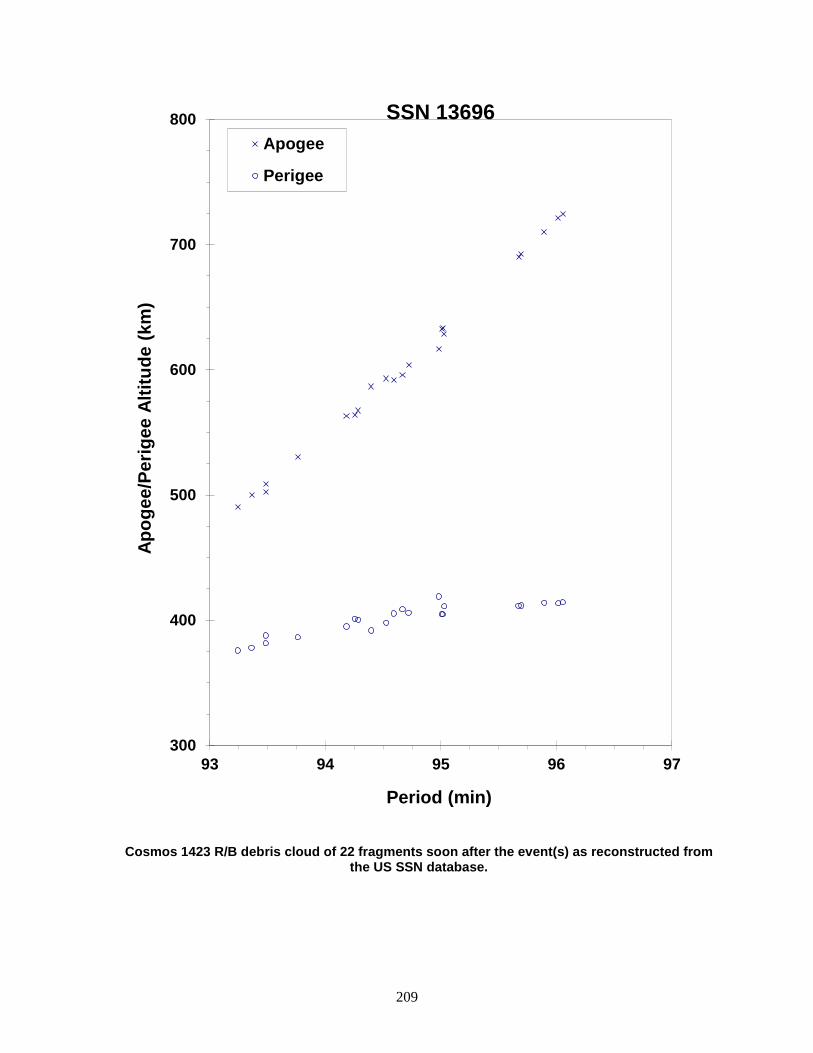
209
Cosmos 1423 R/B debris cloud of 22 fragments soon after the event(s) as reconstructed from the US SSN database.
300
400
500
600
700
800
93 94 95 96 97
Apog
ee/P
erig
ee A
ltitu
de (k
m)
Period (min)
Apogee
Perigee
SSN 13696
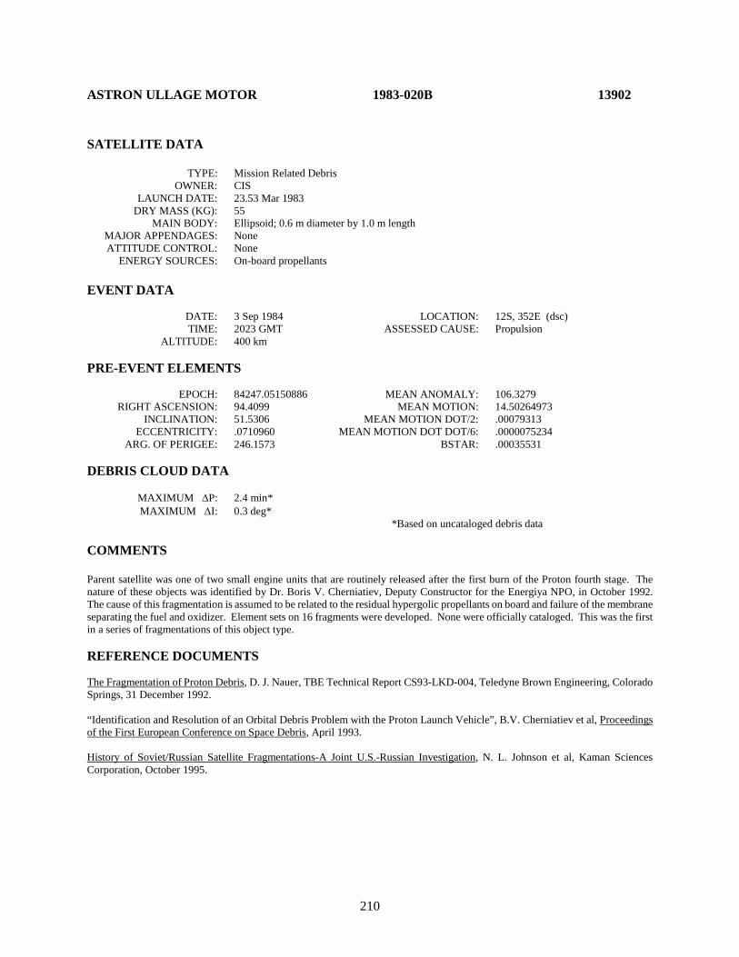
210
ASTRON ULLAGE MOTOR 1983-020B 13902 SATELLITE DATA TYPE: Mission Related Debris OWNER: CIS LAUNCH DATE: 23.53 Mar 1983 DRY MASS (KG): 55 MAIN BODY: Ellipsoid; 0.6 m diameter by 1.0 m length MAJOR APPENDAGES: None ATTITUDE CONTROL: None ENERGY SOURCES: On-board propellants EVENT DATA DATE: 3 Sep 1984 LOCATION: 12S, 352E (dsc) TIME: 2023 GMT ASSESSED CAUSE: Propulsion ALTITUDE: 400 km PRE-EVENT ELEMENTS EPOCH: 84247.05150886 MEAN ANOMALY: 106.3279 RIGHT ASCENSION: 94.4099 MEAN MOTION: 14.50264973 INCLINATION: 51.5306 MEAN MOTION DOT/2: .00079313 ECCENTRICITY: .0710960 MEAN MOTION DOT DOT/6: .0000075234 ARG. OF PERIGEE: 246.1573 BSTAR: .00035531 DEBRIS CLOUD DATA MAXIMUM ∆P: 2.4 min* MAXIMUM ∆I: 0.3 deg* *Based on uncataloged debris data COMMENTS Parent satellite was one of two small engine units that are routinely released after the first burn of the Proton fourth stage. The nature of these objects was identified by Dr. Boris V. Cherniatiev, Deputy Constructor for the Energiya NPO, in October 1992. The cause of this fragmentation is assumed to be related to the residual hypergolic propellants on board and failure of the membrane separating the fuel and oxidizer. Element sets on 16 fragments were developed. None were officially cataloged. This was the first in a series of fragmentations of this object type. REFERENCE DOCUMENTS The Fragmentation of Proton Debris, D. J. Nauer, TBE Technical Report CS93-LKD-004, Teledyne Brown Engineering, Colorado Springs, 31 December 1992. “Identification and Resolution of an Orbital Debris Problem with the Proton Launch Vehicle”, B.V. Cherniatiev et al, Proceedings of the First European Conference on Space Debris, April 1993. History of Soviet/Russian Satellite Fragmentations-A Joint U.S.-Russian Investigation, N. L. Johnson et al, Kaman Sciences Corporation, October 1995.
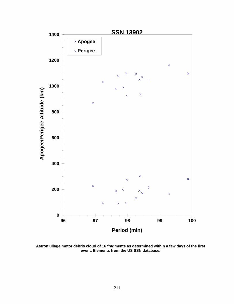
211
Astron ullage motor debris cloud of 16 fragments as determined within a few days of the first event. Elements from the US SSN database.
0
200
400
600
800
1000
1200
1400
96 97 98 99 100
Apog
ee/P
erig
ee A
ltitu
de (k
m)
Period (min)
Apogee
Perigee
SSN 13902
212
NOAA 8 1983-022A 13923 SATELLITE DATA TYPE: Payload OWNER: US LAUNCH DATE: 28.66 Mar 1983 DRY MASS (KG): 1000 MAIN BODY: Cylinder-box; 1.9 m diameter by 7.5 m length MAJOR APPENDAGES: 1 solar panel ATTITUDE CONTROL: Active, 3-axis ENERGY SOURCES: On-board propellants EVENT DATA DATE: 30 Dec 1985 LOCATION: 68S, 300E (dsc) TIME: 1005 GMT ASSESSED CAUSE: Battery ALTITUDE: 825 km PRE-EVENT ELEMENTS EPOCH: 85348.40460348 MEAN ANOMALY: 83.2801 RIGHT ASCENSION: 16.9717 MEAN MOTION: 14.22481975 INCLINATION: 98.6488 MEAN MOTION DOT/2: .00000037 ECCENTRICITY: .0015724 MEAN MOTION DOT DOT/6: .0 ARG. OF PERIGEE: 276.6589 BSTAR: .000025130 DEBRIS CLOUD DATA MAXIMUM ∆P: 4.7 min MAXIMUM ∆I: 0.1 deg COMMENTS A malfunction on NOAA 8 caused a battery to overcharge, resulting in a minor explosion of the battery. The spacecraft was operational at the time of the event. Six new fragments were detected and cataloged. All decayed by February 1989, leaving the parent still in orbit. REFERENCE DOCUMENT "NOAA Turns Off Satellite Following Malfunction", Aviation Week and Space Technology, 13 January 1986, p. 21.
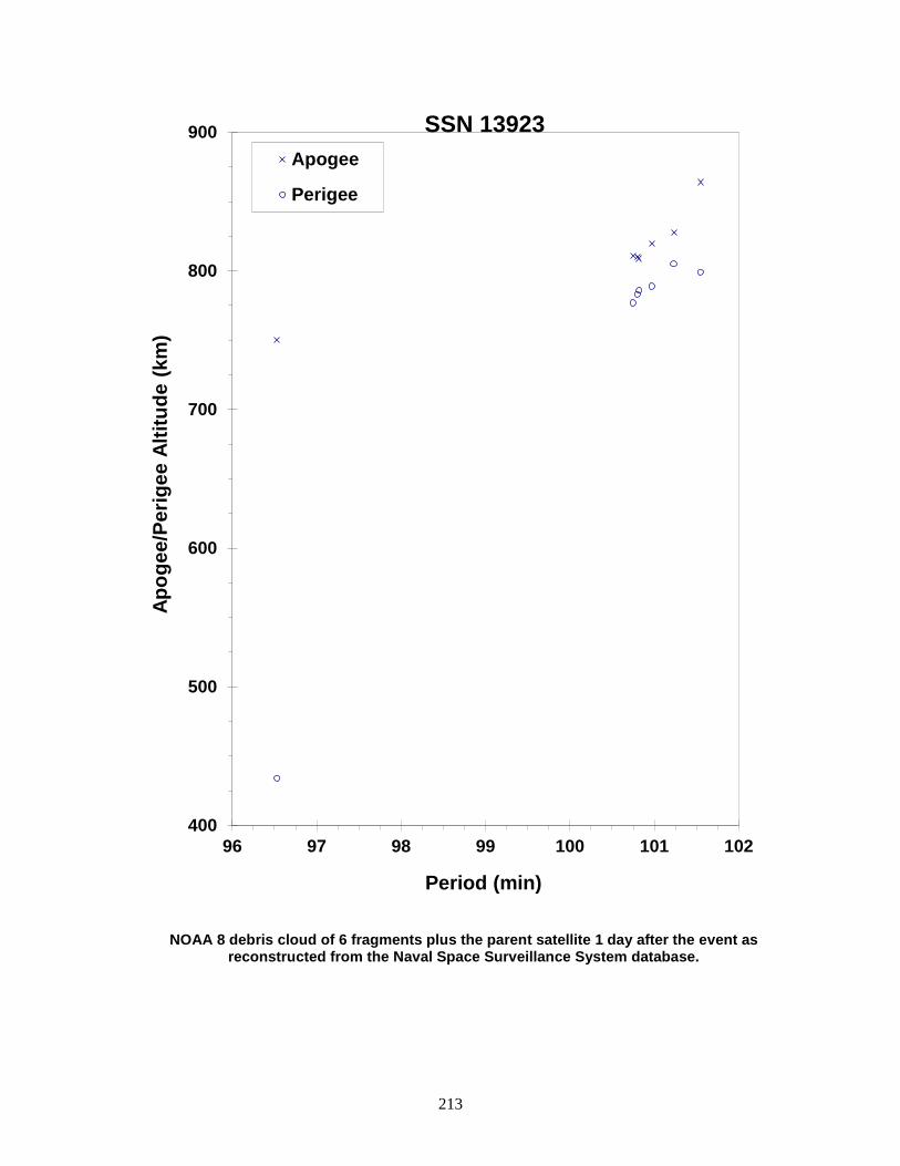
213
NOAA 8 debris cloud of 6 fragments plus the parent satellite 1 day after the event as reconstructed from the Naval Space Surveillance System database.
400
500
600
700
800
900
96 97 98 99 100 101 102
Apog
ee/P
erig
ee A
ltitu
de (k
m)
Period (min)
Apogee
Perigee
SSN 13923

214
COSMOS 1456 1983-038A 14034 SATELLITE DATA TYPE: Payload OWNER: CIS LAUNCH DATE: 25.81 Apr 1983 DRY MASS (KG): 1250 MAIN BODY: Cylinder; 1.7 m diameter by 2 m length MAJOR APPENDAGES: Solar panels ATTITUDE CONTROL: Active, 3-axis ENERGY SOURCES: On-board propellants, explosive charge EVENT DATA DATE: 13 Aug 1983 LOCATION: Unknown TIME: Unknown ASSESSED CAUSE: Deliberate ALTITUDE: Unknown PRE-EVENT ELEMENTS EPOCH: 83225.00107283 MEAN ANOMALY: 4.5332 RIGHT ASCENSION: 79.8630 MEAN MOTION: 2.00589678 INCLINATION: 63.3076 MEAN MOTION DOT/2: .0 ECCENTRICITY: .7324437 MEAN MOTION DOT DOT/6: .0 ARG. OF PERIGEE: 320.0041 BSTAR: .0068163 DEBRIS CLOUD DATA MAXIMUM ∆P: 4.8 min* MAXIMUM ∆I: 0.4 deg* *Based on uncataloged debris data COMMENTS Cosmos 1456 was another spacecraft of the Cosmos 862-type to experience a fragmentation. The spacecraft may have been active at the time of the event, having last made a station-keeping maneuver on 22 June 1983. The next station-keeping maneuver should have occurred in the second half of August or early September 1983. The spacecraft began drifting off station immediately after the event and never recovered. REFERENCE DOCUMENT History of Soviet/Russian Satellite Fragmentations-A Joint U.S.-Russian Investigation, N. L. Johnson et al, Kaman Sciences Corporation, October 1995.

215
Cosmos 1456 debris cloud of 6 fragments less than 3 weeks after the event as reconstructed
from the US SSN database.
0
10000
20000
30000
40000
50000
716 718 720 722 724
Apog
ee/P
erig
ee A
ltitu
de (k
m)
Period (min)
Apogee
Perigee
SSN 14034
216
COSMOS 1461 1983-044A 14064
SATELLITE DATA TYPE: Payload OWNER: CIS LAUNCH DATE: 7.44 May 1983 DRY MASS (KG): 3000 MAIN BODY: Cylinder; 1.3 m diameter by 17 m length MAJOR APPENDAGES: Solar panels ATTITUDE CONTROL: Active, 3-axis ENERGY SOURCES: On-board propellants, explosive charge (?) EVENT DATA (1) DATE: 11 Mar 1985 LOCATION: 4S, 196E (asc) TIME: 0940 GMT ASSESSED CAUSE: Unknown ALTITUDE: 750 km PRE-EVENT ELEMENTS (1) EPOCH: 85068.60956125 MEAN ANOMALY: 101.2285 RIGHT ASCENSION: 157.6403 MEAN MOTION: 14.49322542 INCLINATION: 65.0244 MEAN MOTION DOT/2: .00000357 ECCENTRICITY: .0224980 MEAN MOTION DOT DOT/6: .0 ARG. OF PERIGEE: 256.3703 BSTAR: .000080310 EVENT DATA (2) DATE: 13 May 1985 LOCATION: 10N, 82E (asc) TIME: 0133 GMT ASSESSED CAUSE: Unknown ALTITUDE: 845 km PRE-EVENT ELEMENTS (2) EPOCH: 85125.54047130 MEAN ANOMALY: 121.1528 RIGHT ASCENSION: 353.4544 MEAN MOTION: 14.49239036 INCLINATION: 65.0248 MEAN MOTION DOT/2: .0 ECCENTRICITY: .0222492 MEAN MOTION DOT DOT/6: .0 ARG. OF PERIGEE: 236.8082 BSTAR: .0 DEBRIS CLOUD DATA MAXIMUM ∆P: 5.9 min* MAXIMUM ∆I: 1.0 deg* *Based on uncataloged debris data COMMENTS Cosmos 1461 was the twelfth spacecraft of the Cosmos 699-type to experience a fragmentation. Cosmos 1461 entered a natural decay regime more than 13 months prior to first event. After the first event as many as 20 fragments were detected but only six new objects were cataloged. The second event occurred 2 months later and produced considerably more debris. These events followed the pattern set by Cosmos 1220 and Cosmos 1260.
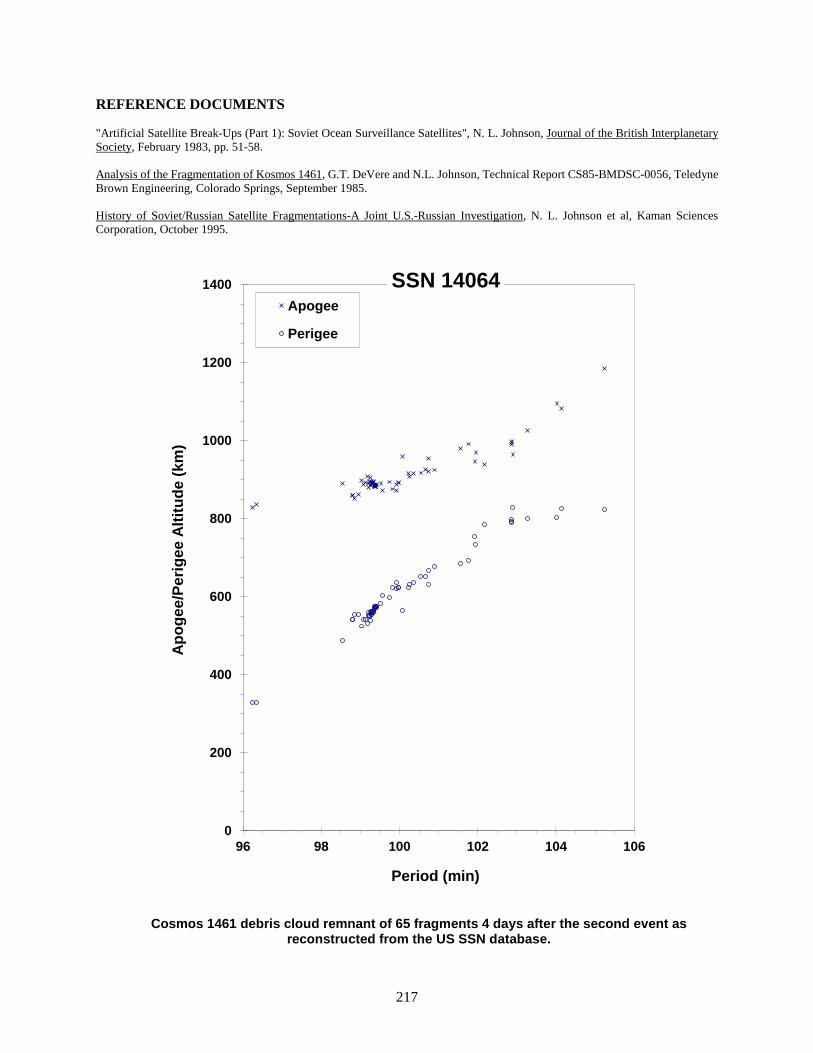
217
REFERENCE DOCUMENTS "Artificial Satellite Break-Ups (Part 1): Soviet Ocean Surveillance Satellites", N. L. Johnson, Journal of the British Interplanetary Society, February 1983, pp. 51-58. Analysis of the Fragmentation of Kosmos 1461, G.T. DeVere and N.L. Johnson, Technical Report CS85-BMDSC-0056, Teledyne Brown Engineering, Colorado Springs, September 1985. History of Soviet/Russian Satellite Fragmentations-A Joint U.S.-Russian Investigation, N. L. Johnson et al, Kaman Sciences Corporation, October 1995.
Cosmos 1461 debris cloud remnant of 65 fragments 4 days after the second event as reconstructed from the US SSN database.
0
200
400
600
800
1000
1200
1400
96 98 100 102 104 106
Apo
gee/
Perig
ee A
ltitu
de (k
m)
Period (min)
Apogee
Perigee
SSN 14064

218
COSMOS 1481 1983-070A 14182 SATELLITE DATA TYPE: Payload OWNER: CIS LAUNCH DATE: 8.80 Jul 1983 DRY MASS (KG): 1250 MAIN BODY: Cylinder; 1.7 m diameter by 2 m length MAJOR APPENDAGES: Solar panels ATTITUDE CONTROL: Active, 3-axis ENERGY SOURCES: On-board propellants, explosive charge EVENT DATA DATE: 9 Jul 1983 LOCATION: Unknown TIME: Unknown ASSESSED CAUSE: Deliberate ALTITUDE: Unknown PRE-EVENT ELEMENTS EPOCH: 83189.85702098 MEAN ANOMALY: 4.6462 RIGHT ASCENSION: 166.3194 MEAN MOTION: 2.03523282 INCLINATION: 62.9394 MEAN MOTION DOT/2: .00000702 ECCENTRICITY: .7337681 MEAN MOTION DOT DOT/6: .0 ARG. OF PERIGEE: 317.9301 BSTAR: .0 DEBRIS CLOUD DATA MAXIMUM ∆P: 8.7 min* MAXIMUM ∆I: 0.8 deg* *Based on uncataloged debris data COMMENTS Cosmos 1481 was the twelfth spacecraft of the Cosmos 862-type to experience a fragmentation. The event apparently occurred within a day of launch. An expected orbital maneuver by Cosmos 1481 to move from its transfer orbit to an operational orbit about 3 days after launch was never performed. REFERENCE DOCUMENT History of Soviet/Russian Satellite Fragmentations-A Joint U.S.-Russian Investigation, N. L. Johnson et al, Kaman Sciences Corporation, October 1995.
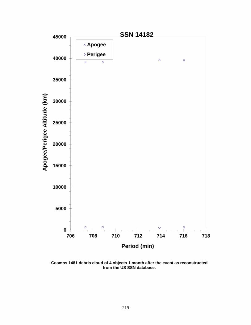
219
Cosmos 1481 debris cloud of 4 objects 1 month after the event as reconstructed from the US SSN database.
0
5000
10000
15000
20000
25000
30000
35000
40000
45000
706 708 710 712 714 716 718
Apog
ee/P
erig
ee A
ltitu
de (k
m)
Period (min)
Apogee
Perigee
SSN 14182
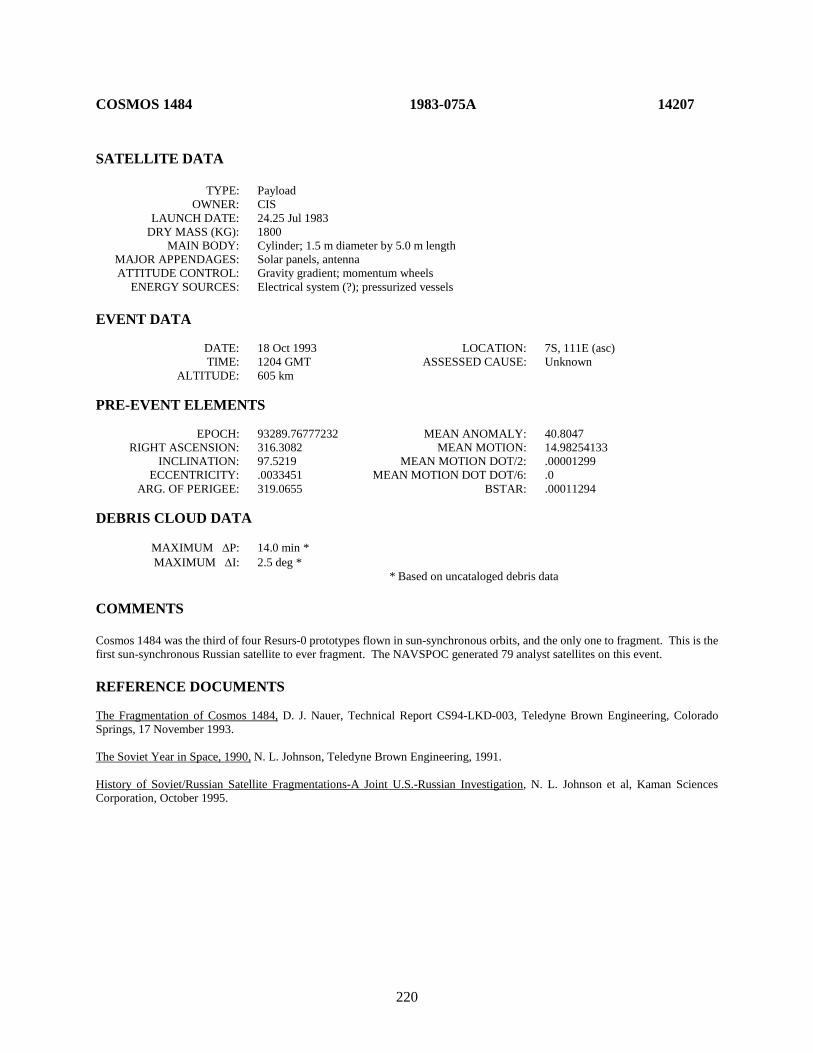
220
COSMOS 1484 1983-075A 14207 SATELLITE DATA TYPE: Payload OWNER: CIS LAUNCH DATE: 24.25 Jul 1983 DRY MASS (KG): 1800 MAIN BODY: Cylinder; 1.5 m diameter by 5.0 m length MAJOR APPENDAGES: Solar panels, antenna ATTITUDE CONTROL: Gravity gradient; momentum wheels ENERGY SOURCES: Electrical system (?); pressurized vessels EVENT DATA DATE: 18 Oct 1993 LOCATION: 7S, 111E (asc) TIME: 1204 GMT ASSESSED CAUSE: Unknown ALTITUDE: 605 km PRE-EVENT ELEMENTS EPOCH: 93289.76777232 MEAN ANOMALY: 40.8047 RIGHT ASCENSION: 316.3082 MEAN MOTION: 14.98254133 INCLINATION: 97.5219 MEAN MOTION DOT/2: .00001299 ECCENTRICITY: .0033451 MEAN MOTION DOT DOT/6: .0 ARG. OF PERIGEE: 319.0655 BSTAR: .00011294 DEBRIS CLOUD DATA MAXIMUM ∆P: 14.0 min * MAXIMUM ∆I: 2.5 deg * * Based on uncataloged debris data COMMENTS Cosmos 1484 was the third of four Resurs-0 prototypes flown in sun-synchronous orbits, and the only one to fragment. This is the first sun-synchronous Russian satellite to ever fragment. The NAVSPOC generated 79 analyst satellites on this event. REFERENCE DOCUMENTS The Fragmentation of Cosmos 1484, D. J. Nauer, Technical Report CS94-LKD-003, Teledyne Brown Engineering, Colorado Springs, 17 November 1993. The Soviet Year in Space, 1990, N. L. Johnson, Teledyne Brown Engineering, 1991. History of Soviet/Russian Satellite Fragmentations-A Joint U.S.-Russian Investigation, N. L. Johnson et al, Kaman Sciences Corporation, October 1995.
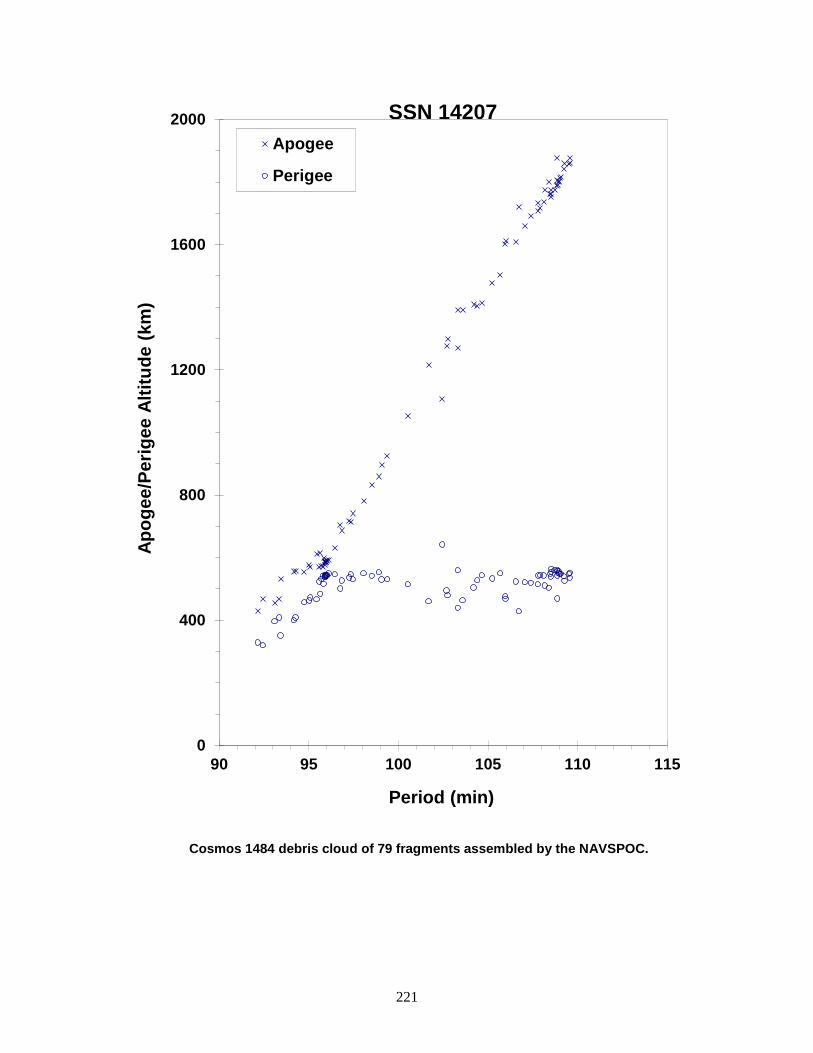
221
Cosmos 1484 debris cloud of 79 fragments assembled by the NAVSPOC.
0
400
800
1200
1600
2000
90 95 100 105 110 115
Apog
ee/P
erig
ee A
ltitu
de (k
m)
Period (min)
Apogee
Perigee
SSN 14207
222
COSMOS 1519-1521 ULLAGE MOTOR 1983-127H 14608 SATELLITE DATA TYPE: Mission Related Debris OWNER: CIS LAUNCH DATE: 29.04 Dec 1983 DRY MASS (KG): 55 MAIN BODY: Ellipsoid; 0.6 m diameter by 1 m length MAJOR APPENDAGES: None ATTITUDE CONTROL: None ENERGY SOURCES: On-board propellants EVENT DATA DATE: 4 Feb 1991 LOCATION: 28N, 106E (dsc) TIME: 0312 GMT ASSESSED CAUSE: Propulsion ALTITUDE: 18550 km PRE-EVENT ELEMENTS EPOCH: 91032.22560633 MEAN ANOMALY: 10.4843 RIGHT ASCENSION: 133.4557 MEAN MOTION: 4.30882556 INCLINATION: 51.9464 MEAN MOTION DOT/2: .00004140 ECCENTRICITY: .5787304 MEAN MOTION DOT DOT/6: .0 ARG. OF PERIGEE: 315.5487 BSTAR: .0018354 DEBRIS CLOUD DATA MAXIMUM ∆P: Unknown MAXIMUM ∆I: Unknown COMMENTS Parent satellite was one of two small engine units that are routinely released after the first burn of the Proton fourth stage. The nature of these objects was identified by Dr. Boris V. Chernlatiev, Deputy Constructor for the Energiya NPO, in October 1992. The cause of this fragmentation is assumed to be related to the residual hypergolic propellants on board and failure of the membrane separating the fuel and oxidizer. NAVSPASUR observed at least 12 fragments on the day of the event and approximately three dozen on 7 February. An element set was initially developed on only one new fragment. This was the third in a series of fragmentations of this object type. REFERENCE DOCUMENTS The Fragmentation of Proton Debris, D. J. Nauer, TBE Technical Report CS93-LKD-004, Teledyne Brown Engineering, Colorado Springs, 31 December 1992.
History of Soviet/Russian Satellite Fragmentations-A Joint U.S.-Russian Investigation, N. L. Johnson et al, Kaman Sciences Corporation, October 1995. “Identification and Resolution of an Orbital Debris Problem with the Proton Launch Vehicle”, B. V. Cherniatiev et al, Proceedings of the First European Conference on Space Debris, April 1993.
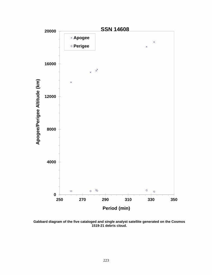
223
Gabbard diagram of the five cataloged and single analyst satellite generated on the Cosmos 1519-21 debris cloud.
0
4000
8000
12000
16000
20000
250 270 290 310 330 350
Apog
ee/P
erig
ee A
ltitu
de (k
m)
Period (min)
Apogee
Perigee
SSN 14608
224
PALAPA B2 R/B 1984-011E 14693 SATELLITE DATA TYPE: PAM-D Upper Stage (STAR 48 motor) OWNER: US LAUNCH DATE: 3.54 Feb 1984 DRY MASS (KG): 2200 MAIN BODY: Sphere-nozzle; 1.2 m by 2.1 m MAJOR APPENDAGES: None ATTITUDE CONTROL: Spin-stabilized ENERGY SOURCES: On-board propellants EVENT DATA DATE: 6 Feb 1984 LOCATION: 0N, 120E (asc) TIME: 1600 GMT ASSESSED CAUSE: Propulsion ALTITUDE: 280 km PRE-EVENT ELEMENTS EPOCH: 84037.35377144 MEAN ANOMALY: 82.4657 RIGHT ASCENSION: 138.8370 MEAN MOTION: 15.97451864 INCLINATION: 28.4669 MEAN MOTION DOT/2: .00197501 ECCENTRICITY: .0006481 MEAN MOTION DOT DOT/6: .0 ARG. OF PERIGEE: 277.3659 BSTAR: .00040999 DEBRIS CLOUD DATA MAXIMUM ∆P: 9.4 min* MAXIMUM ∆I: 0.3 deg* *Based on uncataloged debris data COMMENTS Palapa B2 and its PAM-D upper stage were deployed from the Space Shuttle Challenger at 1513 GMT, 6 February 1984. Ignition of the upper stage occurred on schedule at 1600 GMT, but the nozzle fragmented within 10 seconds. Without the nozzle the burn could not be sustained and a natural shutdown quickly followed. The PAM-D then separated from Palapa B2. The above elements are for the Shuttle prior to deployment. The Shuttle made a small posigrade evasive maneuver after deployment and before ignition of the PAM-D. See also Westar 6 R/B fragmentation.

225
Palapa B2 R/B debris cloud of 5 fragments about 3 days after the event as reconstructed from the US SSN database. The Palapa B2 R/B is the object with the
second highest orbital period.
0
200
400
600
800
1000
1200
1400
90 92 94 96 98 100
Apog
ee/P
erig
ee A
ltitu
de (k
m)
Period (min)
Apogee
Perigee
SSN 14693
226
WESTAR 6 R/B 1984-011F 14694 SATELLITE DATA TYPE: PAM-D Upper Stage (STAR 48 motor) OWNER: US LAUNCH DATE: 3.54 Feb 1984 DRY MASS (KG): 2200 MAIN BODY: Sphere-nozzle; 1.2 m by 2.1 m MAJOR APPENDAGES: None ATTITUDE CONTROL: Spin-stabilized ENERGY SOURCES: On-board propellants EVENT DATA DATE: 3 Feb 1984 LOCATION: 0N, 56E (asc) TIME: 2145 GMT ASSESSED CAUSE: Propulsion ALTITUDE: 305 km PRE-EVENT ELEMENTS EPOCH: 84034.84362284 MEAN ANOMALY: 48.7355 RIGHT ASCENSION: 157.5848 MEAN MOTION: 15.88299499 INCLINATION: 28.4660 MEAN MOTION DOT/2: .00000250 ECCENTRICITY: .0006644 MEAN MOTION DOT DOT/6: .0 ARG. OF PERIGEE: 311.2683 BSTAR: .0 DEBRIS CLOUD DATA MAXIMUM ∆P: 9.7 min MAXIMUM ∆I: 0.8 deg COMMENTS Westar 6 and its PAM-D upper stage were deployed from the Space Shuttle Challenger at 2100 GMT, 3 February 1984. Ignition of the upper stage occurred on schedule at 2145 GMT but the nozzle fragmented within 10 seconds. Without the nozzle the burn could not be sustained and a natural shutdown quickly followed. The PAM-D then separated from Westar 6. See also Palapa B2 R/B fragmentation. REFERENCE DOCUMENT Westar Failure, Technical Memorandum from N.L. Johnson, Teledyne Brown Engineering, to Preston Landry, NORAD/ADCOM/XPYS, Colorado Springs, 7 February 1984.

227
Westar 6 R/B debris cloud of 7 fragments less than 2 days after the event as reconstructed from the US SSN database. The Westar 6 R/B is the object in the high, 100-min orbit.
0
200
400
600
800
1000
1200
1400
90 92 94 96 98 100 102
Apog
ee/P
erig
ee A
ltitu
de (k
m)
Period (min)
Apogee
Perigee
SSN 14694

228
COSMOS 1588 1984-083A 15167 SATELLITE DATA TYPE: Payload OWNER: CIS LAUNCH DATE: 7.95 Aug 1984 DRY MASS (KG): 3000 MAIN BODY: Cylinder; 1.3 m diameter by 17 m length MAJOR APPENDAGES: Solar panels ATTITUDE CONTROL: Active, 3-axis ENERGY SOURCES: On-board propellants, explosive charge (?) EVENT DATA DATE: 23 Feb 1986 LOCATION: 29N, 187E (asc) TIME: 1850 GMT ASSESSED CAUSE: Unknown ALTITUDE: 430 km PRE-EVENT ELEMENTS EPOCH: 86048.57631415 MEAN ANOMALY: 72.5463 RIGHT ASCENSION: 268.3025 MEAN MOTION: 15.47795866 INCLINATION: 65.0271 MEAN MOTION DOT/2: .00005888 ECCENTRICITY: .0022403 MEAN MOTION DOT DOT/6: .0 ARG. OF PERIGEE: 287.3230 BSTAR: .00011680 DEBRIS CLOUD DATA MAXIMUM ∆P: 2.0 min MAXIMUM ∆I: 0.4 deg COMMENTS Cosmos 1588 was the thirteenth spacecraft of the Cosmos 699-type to experience a fragmentation. Spacecraft had been in natural decay for 7 months prior to the event. REFERENCE DOCUMENTS "Artificial Satellite Break-Ups (Part 1): Soviet Ocean Surveillance Satellites", N. L. Johnson, Journal of the British Interplanetary Society, February 1983, pp. 51-58. History of Soviet/Russian Satellite Fragmentations-A Joint U.S.-Russian Investigation, N. L. Johnson et al, Kaman Sciences Corporation, October 1995.
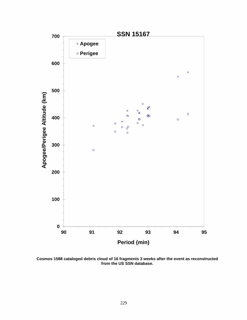
229
Cosmos 1588 cataloged debris cloud of 16 fragments 3 weeks after the event as reconstructed from the US SSN database.
0
100
200
300
400
500
600
700
90 91 92 93 94 95
Apog
ee/P
erig
ee A
ltitu
de (k
m)
Period (min)
Apogee
Perigee
SSN 15167

230
COSMOS 1603 ULLAGE MOTOR 1984-106F 15338 SATELLITE DATA TYPE: Mission Related Debris OWNER: CIS LAUNCH DATE: 28.58 Sep 1984 DRY MASS (KG): 55 MAIN BODY: Ellipsoid; 0.6 m diameter by 1 m length MAJOR APPENDAGES: None ATTITUDE CONTROL: None ENERGY SOURCES: On-board propellants EVENT DATA DATE: 5 Sep 1992 LOCATION: 46.1S, 351.8E TIME: 1451 GMT ASSESSED CAUSE: Propulsion ALTITUDE: 835 km PRE-EVENT ELEMENTS EPOCH: 92249.36121283 MEAN ANOMALY: 6.5555 RIGHT ASCENSION: 353.4197 MEAN MOTION: 14.15474339 INCLINATION: 66.5712 MEAN MOTION DOT/2: -.00009086 ECCENTRICITY: .0007128 MEAN MOTION DOT DOT/6: .0 ARG. OF PERIGEE: 353.5641 BSTAR: -.004641 DEBRIS CLOUD DATA MAXIMUM ∆P: 2.9 min MAXIMUM ∆I: 0.5 deg COMMENTS Parent satellite was one of two small engine units that are routinely released after the first burn of the Proton fourth stage. The nature of these objects was identified by Dr. Boris V. Chernlatiev, Deputy Constructor for the Energiya NPO, in October 1992. The cause of this fragmentation is assumed to be related to the residual hypergolic propellants on board and failure of the membrane separating the fuel and oxidizer. NAVSPASUR has observed 62 objects associated with this breakup. This was the sixth in a series of fragmentations of this object type. REFERENCE DOCUMENTS Soviet Space Programs 1980-1985, Science and Technology Series, Volume 66, Nicholas L. Johnson, American Astronautical Society, Univelt, Inc., 1987. The Fragmentation of Proton Debris, D. J. Nauer, TBE Technical Report CS93-LKD-004, Teledyne Brown Engineering, Colorado Springs, 31 December 1992. History of Soviet/Russian Satellite Fragmentations-A Joint U.S.-Russian Investigation, N. L. Johnson et al, Kaman Sciences Corporation, October 1995. “Identification and Resolution of an Orbital Debris Problem with the Proton Launch Vehicle”, B. V. Cherniatiev et al, Proceedings of the First European Conference on Space Debris, April 1993.
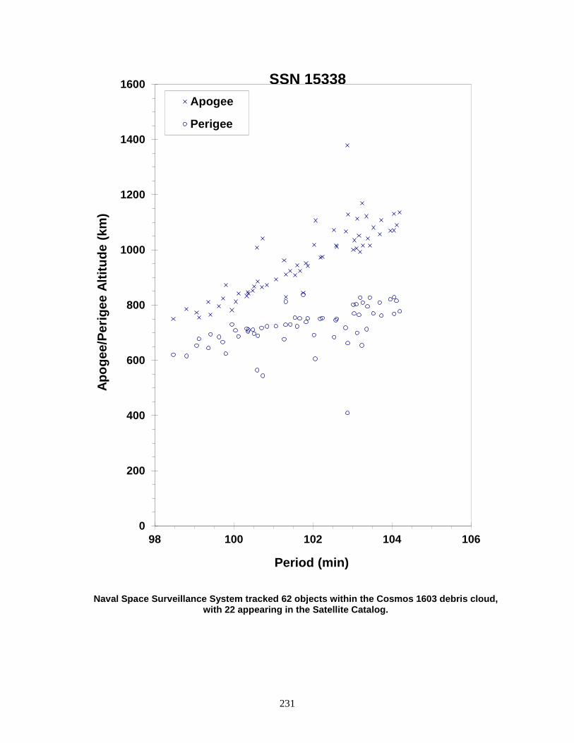
231
Naval Space Surveillance System tracked 62 objects within the Cosmos 1603 debris cloud, with 22 appearing in the Satellite Catalog.
0
200
400
600
800
1000
1200
1400
1600
98 100 102 104 106
Apog
ee/P
erig
ee A
ltitu
de (k
m)
Period (min)
Apogee
Perigee
SSN 15338

232
SPACENET 2/MARECS B2 R/B 1984-114C 15388 SATELLITE DATA TYPE: Ariane 3 Final Stage OWNER: France LAUNCH DATE: 10.05 Nov 1984 DRY MASS (KG): ~1100 MAIN BODY: Unknown MAJOR APPENDAGES: None ATTITUDE CONTROL: None ENERGY SOURCES: On-board propellants EVENT DATA DATE: 20 Nov 1984 LOCATION: Unknown TIME: 1425Z ASSESSED CAUSE: Propulsion ALTITUDE: Unknown PRE-EVENT ELEMENTS EPOCH: 84325.41617 MEAN ANOMALY: 146.5463 RIGHT ASCENSION: 236.1289 MEAN MOTION: 2.26087292 INCLINATION: 7.0293 MEAN MOTION DOT/2: .00001128 ECCENTRICITY: .7265710 MEAN MOTION DOT DOT/6: .0 ARG. OF PERIGEE: 187.8823 BSTAR: .0010954 DEBRIS CLOUD DATA MAXIMUM ∆P: Unknown MAXIMUM ∆I: Unknown COMMENTS This Ariane R/B fragmentation occurred to 10 days after launch but not detected until 2003. This is the first Ariane Rocket Body fragmentation that is attributed to France. Previous Ariane Stages were attributed to ESA.

233
Insufficient data to construct a Gabbard diagram.
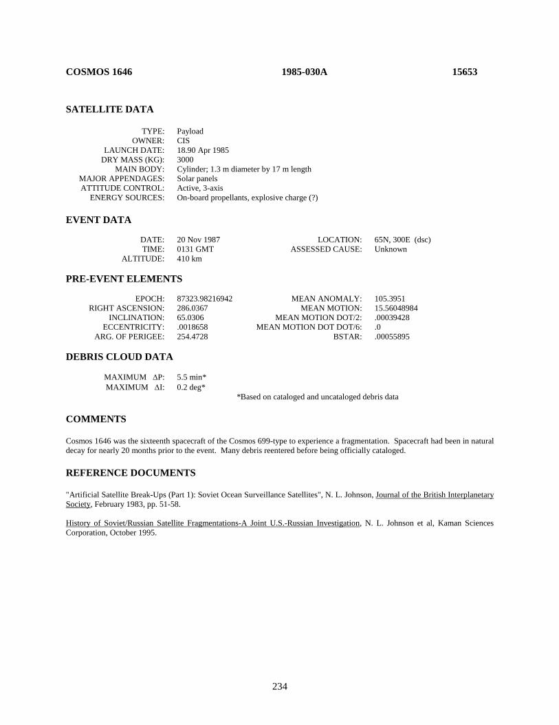
234
COSMOS 1646 1985-030A 15653 SATELLITE DATA TYPE: Payload OWNER: CIS LAUNCH DATE: 18.90 Apr 1985 DRY MASS (KG): 3000 MAIN BODY: Cylinder; 1.3 m diameter by 17 m length MAJOR APPENDAGES: Solar panels ATTITUDE CONTROL: Active, 3-axis ENERGY SOURCES: On-board propellants, explosive charge (?) EVENT DATA DATE: 20 Nov 1987 LOCATION: 65N, 300E (dsc) TIME: 0131 GMT ASSESSED CAUSE: Unknown ALTITUDE: 410 km PRE-EVENT ELEMENTS EPOCH: 87323.98216942 MEAN ANOMALY: 105.3951 RIGHT ASCENSION: 286.0367 MEAN MOTION: 15.56048984 INCLINATION: 65.0306 MEAN MOTION DOT/2: .00039428 ECCENTRICITY: .0018658 MEAN MOTION DOT DOT/6: .0 ARG. OF PERIGEE: 254.4728 BSTAR: .00055895 DEBRIS CLOUD DATA MAXIMUM ∆P: 5.5 min* MAXIMUM ∆I: 0.2 deg* *Based on cataloged and uncataloged debris data COMMENTS Cosmos 1646 was the sixteenth spacecraft of the Cosmos 699-type to experience a fragmentation. Spacecraft had been in natural decay for nearly 20 months prior to the event. Many debris reentered before being officially cataloged. REFERENCE DOCUMENTS "Artificial Satellite Break-Ups (Part 1): Soviet Ocean Surveillance Satellites", N. L. Johnson, Journal of the British Interplanetary Society, February 1983, pp. 51-58. History of Soviet/Russian Satellite Fragmentations-A Joint U.S.-Russian Investigation, N. L. Johnson et al, Kaman Sciences Corporation, October 1995.
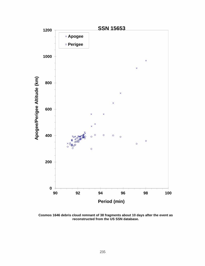
235
Cosmos 1646 debris cloud remnant of 38 fragments about 10 days after the event as reconstructed from the US SSN database.
0
200
400
600
800
1000
1200
90 92 94 96 98 100
Apog
ee/P
erig
ee A
ltitu
de (k
m)
Period (min)
Apogee
Perigee
SSN 15653

236
COSMOS 1650-1652 ULLAGE MOTOR 1985-037G 15714 SATELLITE DATA TYPE: Mission Related Debris OWNER: CIS LAUNCH DATE: 17 May 1985 DRY MASS (KG): 55 MAIN BODY: Ellipsoid; 0.6 m diameter by 1 m length MAJOR APPENDAGES: None ATTITUDE CONTROL: None ENERGY SOURCES: On-board propellants EVENT DATA DATE: 29 Nov 1998 LOCATION: 38.3N, 172.6E TIME: 0925 GMT ASSESSED CAUSE: Propulsion ALTITUDE: 16420 km POST-EVENT ELEMENTS EPOCH: 98332.38151447 MEAN ANOMALY: 98.9018 RIGHT ASCENSION: 344.4719 MEAN MOTION: 4.35077855212150 INCLINATION: 52.0277 MEAN MOTION DOT/2: .00009109 ECCENTRICITY: .5772516 MEAN MOTION DOT DOT/6: 00000-0 ARG. OF PERIGEE: 209.7130 BSTAR: .030939 DEBRIS CLOUD DATA MAXIMUM ∆P: 91.18 min MAXIMUM ∆I: .76 deg COMMENTS This is the 18th event of the Proton Block DM SOZ Ullage Motor class identified to date; it is the seventh associated with a GLONASS mission. This mission was conducted before the engineering defect was identified and passivation measures implemented. In this orbit, debris may be long-lived but hard to track. A total of 60 debris objects were detected. REFERENCE DOCUMENT “1998 Ends with Eighth Satellite Breakup”, The Orbital Debris Quarterly News, NASA JSC, January 1999. Available online at https://orbitaldebris.jsc.nasa.gov/quarterly-news/pdfs/ODQNv4i1.pdf.

237
Cosmos 1650-1652 ullage motor debris cloud of 4 fragments within 1 day of the event as reconstructed from the US SSN database.
0
5000
10000
15000
20000
25000
200 220 240 260 280 300 320 340 360 380 400
Apog
ee/P
erig
ee A
ltitu
de (k
m)
Period (min)
Apogee
Perigee
SSN 15714
238
COSMOS 1654 1985-039A 15734 SATELLITE DATA TYPE: Payload OWNER: CIS LAUNCH DATE: 23.53 May 1985 DRY MASS (KG): 5700 MAIN BODY: Cone-cylinder; 2.7 m diameter by 6.3 m length MAJOR APPENDAGES: Solar panels ATTITUDE CONTROL: Active, 3-axis ENERGY SOURCES: On-board propellants, explosive charge EVENT DATA DATE: 21 Jun 1985 LOCATION: 8N, 292E (asc) TIME: 1047 GMT ASSESSED CAUSE: Deliberate ALTITUDE: 200 km PRE-EVENT ELEMENTS EPOCH: 85172.01363851 MEAN ANOMALY: 313.0734 RIGHT ASCENSION: 1.2391 MEAN MOTION: 16.11890623 INCLINATION: 64.8566 MEAN MOTION DOT/2: .00311214 ECCENTRICITY: .0086971 MEAN MOTION DOT DOT/6: .000034493 ARG. OF PERIGEE: 47.8764 BSTAR: .00015520 DEBRIS CLOUD DATA MAXIMUM ∆P: 22.1 min* MAXIMUM ∆I: 1.5 deg* *Based on uncataloged debris data COMMENTS Spacecraft was destroyed after a malfunction prevented controlled reentry and landing in the Soviet Union. Most debris reentered before being officially cataloged. REFERENCE DOCUMENTS Analysis of the Fragmentation of Kosmos 1654, G.T. DeVere, Technical Report CS86-BMDSC-0003, Teledyne Brown Engineering, Colorado Springs, October 1985. History of Soviet/Russian Satellite Fragmentations-A Joint U.S.-Russian Investigation, N. L. Johnson et al, Kaman Sciences Corporation, October 1995.

239
Cosmos 1654 debris cloud remnant of 543 fragments seen 9 hours after the event by the US SSN PARCS radar.
-1000
-500
0
500
1000
1500
2000
2500
3000
75 85 95 105 115
Apog
ee/P
erig
ee A
ltitu
de (k
m)
Period (min)
Apogee
Perigee
SSN 15734
240
COSMOS 1656 ULLAGE MOTOR 1985-042E 15773 SATELLITE DATA TYPE: Mission Related Debris OWNER: CIS LAUNCH DATE: 30.62 May 1985 DRY MASS (KG): 55 MAIN BODY: Ellipsoid; 0.6 m diameter by 1 m length MAJOR APPENDAGES: None ATTITUDE CONTROL: None ENERGY SOURCES: On-board propellants EVENT DATA DATE: 5 Jan 1988 LOCATION: 66N, 151E (asc) TIME: 0147 GMT ASSESSED CAUSE: Propulsion ALTITUDE: 860 km PRE-EVENT ELEMENTS EPOCH: 88002.58690356 MEAN ANOMALY: 91.9605 RIGHT ASCENSION: 205.7335 MEAN MOTION: 14.17143400 INCLINATION: 66.5867 MEAN MOTION DOT/2: .00000144 ECCENTRICITY: .0034143 MEAN MOTION DOT DOT/6: .0 ARG. OF PERIGEE: 267.7562 BSTAR: .000088961 DEBRIS CLOUD DATA MAXIMUM ∆P: 3.3 min MAXIMUM ∆I: 0.0 deg COMMENTS Parent satellite was one of two small engine units that are routinely released after the first burn of the Proton fourth stage. The nature of these objects was identified by Dr. Boris V. Chernlatiev, Deputy Constructor for the Energiya NPO, in October 1992. The cause of this fragmentation is assumed to be related to the residual hypergolic propellants on board and failure of the membrane separating the fuel and oxidizer. NAVSPASUR observed two additional, uncataloged fragments associated with this event. This was the second in a series of fragmentations of this object type. REFERENCE DOCUMENTS The Fragmentation of Proton Debris, D. J. Nauer, TBE Technical Report CS93-LKD-004, Teledyne Brown Engineering, Colorado Springs, 31 December 1992. History of Soviet/Russian Satellite Fragmentations-A Joint U.S.-Russian Investigation, N. L. Johnson et al, Kaman Sciences Corporation, October 1995. “Identification and Resolution of an Orbital Debris Problem with the Proton Launch Vehicle”, B. V. Cherniatiev et al, Proceedings of the First European Conference on Space Debris, April 1993.

241
Fragments from Cosmos 1656 debris as determined 2 weeks after the event. Elements from the US SSN database as published by NASA Goddard Space Flight Center.
0
200
400
600
800
1000
1200
1400
100 101 102 103 104 105 106
Apog
ee/P
erig
ee A
ltitu
de (k
m)
Period (min)
Apogee
Perigee
SSN 15773

242
COSMOS 1682 1985-082A 16054 SATELLITE DATA TYPE: Payload OWNER: CIS LAUNCH DATE: 19.07 Sep 1985 DRY MASS (KG): 3000 MAIN BODY: Cylinder; 1.3 m diameter by 17 m length MAJOR APPENDAGES: Solar panels ATTITUDE CONTROL: Active, 3-axis ENERGY SOURCES: On-board propellants, explosive charge (?) EVENT DATA DATE: 18 Dec 1986 LOCATION: 22S, 292 E (asc) TIME: 2017 GMT ASSESSED CAUSE: Unknown ALTITUDE: 415 km PRE-EVENT ELEMENTS EPOCH: 86351. 87879723 MEAN ANOMALY: 315.5258 RIGHT ASCENSION: 337.4852 MEAN MOTION: 15.45249396 INCLINATION: 65.0089 MEAN MOTION DOT/2: .00011076 ECCENTRICITY: .0068048 MEAN MOTION DOT DOT/6: .0 ARG. OF PERIGEE: 45.1423 BSTAR: .00021714 DEBRIS CLOUD DATA MAXIMUM ∆P: 2.3 min* MAXIMUM ∆I: 0.7 deg* *Based on uncataloged debris data COMMENTS Cosmos 1682 was the 14th spacecraft of the Cosmos 699-type to experience a fragmentation. Spacecraft had been in natural decay for 2 months prior to the event. Many debris reentered before being officially cataloged. REFERENCE DOCUMENTS "Artificial Satellite Break-Ups (Part 1): Soviet Ocean Surveillance Satellites", N. L. Johnson, Journal of the British Interplanetary Society, February 1983, p. 51-58. History of Soviet/Russian Satellite Fragmentations-A Joint U.S.-Russian Investigation, N. L. Johnson et al, Kaman Sciences Corporation, October 1995.
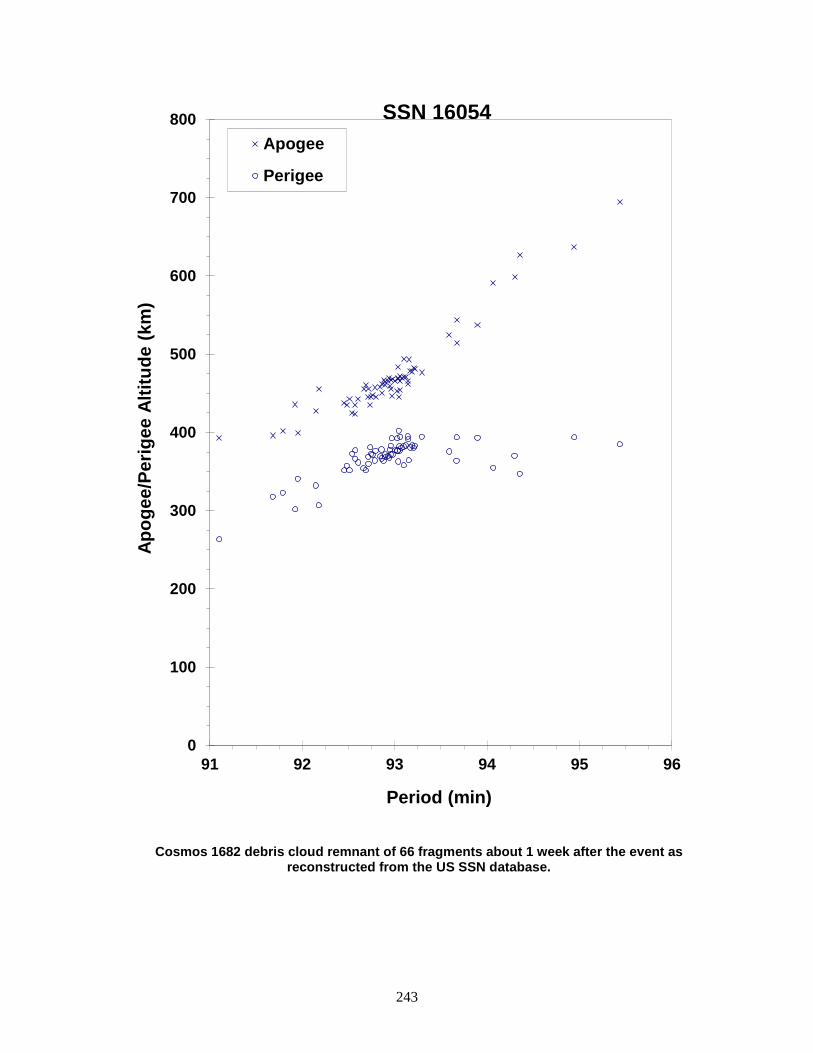
243
Cosmos 1682 debris cloud remnant of 66 fragments about 1 week after the event as reconstructed from the US SSN database.
0
100
200
300
400
500
600
700
800
91 92 93 94 95 96
Apog
ee/P
erig
ee A
ltitu
de (k
m)
Period (min)
Apogee
Perigee
SSN 16054

244
COSMOS 1691 1985-094B 16139 SATELLITE DATA TYPE: Payload OWNER: CIS LAUNCH DATE: 9.90 Oct 1985 DRY MASS (KG): 220 MAIN BODY: Cylinder; 1.0 m diameter by 1.5 m length MAJOR APPENDAGES: Gravity gradient boom ATTITUDE CONTROL: Gravity gradient ENERGY SOURCES: Battery EVENT DATA DATE: 22 Nov 1985 LOCATION: 31N, 326E (dsc) TIME: 0840 GMT ASSESSED CAUSE: Battery ALTITUDE: 1415 km PRE-EVENT ELEMENTS EPOCH: 85320.62059878 MEAN ANOMALY: 91.0897 RIGHT ASCENSION: 345.1807 MEAN MOTION: 12.62038878 INCLINATION: 82.6124 MEAN MOTION DOT/2: .00000022 ECCENTRICITY: .0002812 MEAN MOTION DOT DOT/6: .0 ARG. OF PERIGEE: 268.9870 BSTAR: .000099999 DEBRIS CLOUD DATA MAXIMUM ∆P: 1.0 min MAXIMUM ∆I: 0.1 deg COMMENTS Cosmos 1691 was one of six independent payloads on this launch, which was only the second in this program. Cosmos 1691 was the last payload deployed and may be referred to as Cosmos 1695 in the former Soviet Union. One fragment was administratively decayed in February 1989. No other payloads in this program have fragmented. This event is assessed to be the second known NiH2 battery failure as indicated by Dr. K. M. Suitnshev during the early 1992 Space Debris Conference in Moscow. See also reference below. REFERENCE DOCUMENT History of Soviet/Russian Satellite Fragmentations-A Joint U.S.-Russian Investigation, N. L. Johnson et al, Kaman Sciences Corporation, October 1995.
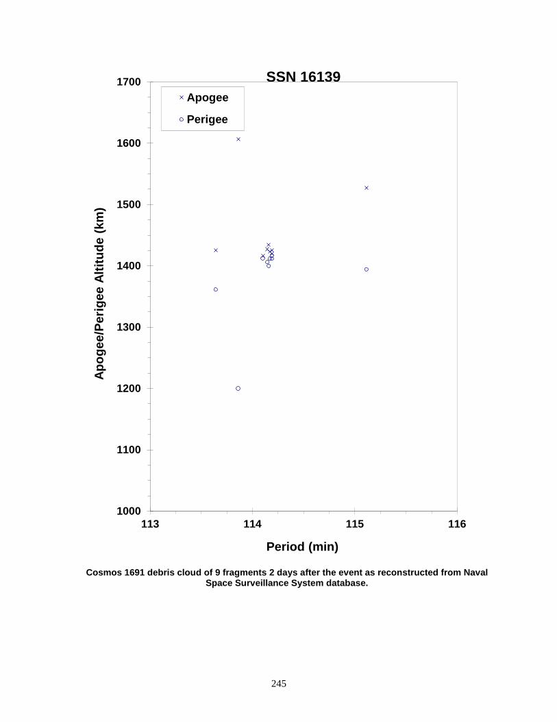
245
Cosmos 1691 debris cloud of 9 fragments 2 days after the event as reconstructed from Naval
Space Surveillance System database.
1000
1100
1200
1300
1400
1500
1600
1700
113 114 115 116
Apog
ee/P
erig
ee A
ltitu
de (k
m)
Period (min)
Apogee
Perigee
SSN 16139
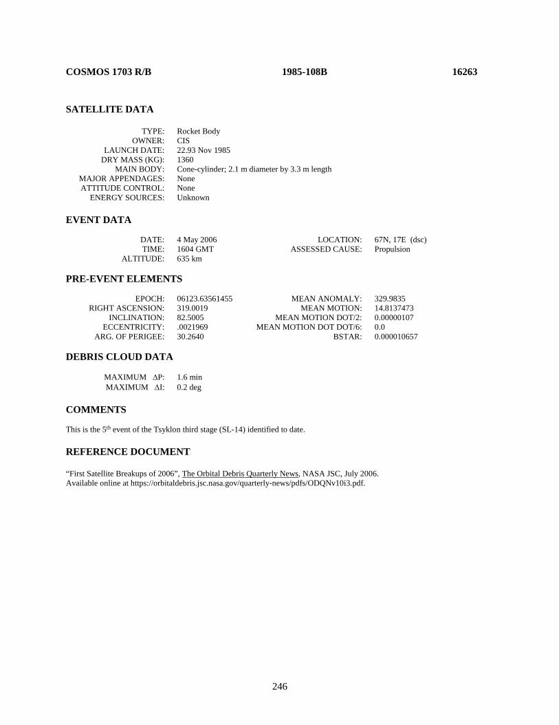
246
COSMOS 1703 R/B 1985-108B 16263 SATELLITE DATA TYPE: Rocket Body OWNER: CIS LAUNCH DATE: 22.93 Nov 1985 DRY MASS (KG): 1360 MAIN BODY: Cone-cylinder; 2.1 m diameter by 3.3 m length MAJOR APPENDAGES: None ATTITUDE CONTROL: None ENERGY SOURCES: Unknown EVENT DATA DATE: 4 May 2006 LOCATION: 67N, 17E (dsc) TIME: 1604 GMT ASSESSED CAUSE: Propulsion ALTITUDE: 635 km PRE-EVENT ELEMENTS EPOCH: 06123.63561455 MEAN ANOMALY: 329.9835 RIGHT ASCENSION: 319.0019 MEAN MOTION: 14.8137473 INCLINATION: 82.5005 MEAN MOTION DOT/2: 0.00000107 ECCENTRICITY: .0021969 MEAN MOTION DOT DOT/6: 0.0 ARG. OF PERIGEE: 30.2640 BSTAR: 0.000010657 DEBRIS CLOUD DATA MAXIMUM ∆P: 1.6 min MAXIMUM ∆I: 0.2 deg COMMENTS This is the 5th event of the Tsyklon third stage (SL-14) identified to date. REFERENCE DOCUMENT “First Satellite Breakups of 2006”, The Orbital Debris Quarterly News, NASA JSC, July 2006. Available online at https://orbitaldebris.jsc.nasa.gov/quarterly-news/pdfs/ODQNv10i3.pdf.
247
Tsyklon third stage debris cloud of 44 fragments six days after the event as reconstructed
from the US SSN database.
500
550
600
650
700
750
800
95.5 96 96.5 97 97.5 98 98.5 99
Period (min)
Apo
gee/
Perig
ee A
ltitu
de (k
m)
Apogee Perigee
SSN 16263
248
COSMOS 1714 R/B 1985-121F 16439 SATELLITE DATA TYPE: Zenit Second Stage OWNER: CIS LAUNCH DATE: 28.40 Dec 1985 DRY MASS (KG): 9000 MAIN BODY: Cylinder; 3.9 m diameter by 12 m length MAJOR APPENDAGES: None ATTITUDE CONTROL: Active, 3-axis ENERGY SOURCES: On-board propellants EVENT DATA DATE: 28 Dec 1985 LOCATION: Unknown TIME: Unknown ASSESSED CAUSE: Propulsion ALTITUDE: Unknown PRE-EVENT ELEMENTS EPOCH: 85363.19328410 MEAN ANOMALY: 84.6199 RIGHT ASCENSION: 281.3886 MEAN MOTION: 14.77971051 INCLINATION: 71.0178 MEAN MOTION DOT/2: 0.00065991 ECCENTRICITY: 0.0306365 MEAN MOTION DOT DOT/6: 0 ARG. OF PERIGEE: 271.9949 BSTAR: 0.0041108 DEBRIS CLOUD DATA MAXIMUM ∆P: Unknown MAXIMUM ∆I: Unknown COMMENTS The Zenit second stage low thrust engine used to perform final orbit insertion exploded. Four pieces of debris cataloged with this mission are probably not associated with the breakup. REFERENCE DOCUMENT History of Soviet/Russian Satellite Fragmentations-A Joint U.S.-Russian Investigation, N. L. Johnson et al, Kaman Sciences Corporation, October 1995.

249
Insufficient data to construct a Gabbard diagram.
250
COSMOS 1710-1712 ULLAGE MOTOR 1985-118L 16446 SATELLITE DATA TYPE: Mission Related Debris OWNER: CIS LAUNCH DATE: 24.91 Dec 1985 DRY MASS (KG): 55 MAIN BODY: Ellipsoid; 0.6 m diameter by 1 m length MAJOR APPENDAGES: None ATTITUDE CONTROL: None ENERGY SOURCES: On-board propellants EVENT DATA DATE: 29 Dec 1991 LOCATION: 25.3N, 331.9E TIME: 0903 GMT ASSESSED CAUSE: Propulsion ALTITUDE: 4730 km PRE-EVENT ELEMENTS EPOCH: 91333.40579226 MEAN ANOMALY: 46.8976 RIGHT ASCENSION: 48.0333 MEAN MOTION: 4.23089679 INCLINATION: 65.2547 MEAN MOTION DOT/2: .00000167 ECCENTRICITY: .5645362 MEAN MOTION DOT DOT/6: .0 ARG. OF PERIGEE: 245.7447 BSTAR: .0012603 DEBRIS CLOUD DATA MAXIMUM ∆P: 5.7 min * MAXIMUM ∆I: 0.8 deg * * based upon uncataloged debris data COMMENTS Parent satellite was one of two small engine units that are routinely released after the first burn of the Proton fourth stage. The nature of these objects was identified by Dr. Boris V. Chernlatiev, Deputy Constructor for the Energiya NPO, in October 1992. The cause of this fragmentation is assumed to be related to the residual hypergolic propellants on board and failure of the membrane separating the fuel and oxidizer. There were 26 objects associated with this event on 30 December per a telecon with NAVSPASUR (Edna Jenkins). Only 2 analyst satellites were generated and insufficient data was available for a Gabbard diagram. This was the fourth in a series of fragmentations of this object type. REFERENCE DOCUMENTS The Fragmentation of Proton Debris, D. J. Nauer, TBE Technical Report CS93-LKD-004, Teledyne Brown Engineering, Colorado Springs, 31 December 1992. History of Soviet/Russian Satellite Fragmentations-A Joint U.S.-Russian Investigation, N. L. Johnson et al, Kaman Sciences Corporation, October 1995. “Identification and Resolution of an Orbital Debris Problem with the Proton Launch Vehicle”, B. V. Cherniatiev et al, Proceedings of the First European Conference on Space Debris, April 1993.

251
Insufficient data to construct a Gabbard diagram.

252
SPOT 1 R/B 1986-019C 16615 SATELLITE DATA TYPE: Ariane 1 Third Stage OWNER: France LAUNCH DATE: 22.07 Feb 1986 DRY MASS (KG): 1400 MAIN BODY: Cylinder; 2.6 m diameter by 10.3 m length MAJOR APPENDAGES: None ATTITUDE CONTROL: None at time of the event. ENERGY SOURCES: On-board propellants, range safety package EVENT DATA DATE: 13 Nov 1986 LOCATION: 7N, 42E (asc) TIME: 1940 GMT ASSESSED CAUSE: Propulsion ALTITUDE: 805 km PRE-EVENT ELEMENTS EPOCH: 86305.08337689 MEAN ANOMALY: 300.1947 RIGHT ASCENSION: 18.0087 MEAN MOTION: 14.22163662 INCLINATION: 98.6973 MEAN MOTION DOT/2: .00000203 ECCENTRICITY: .0021203 MEAN MOTION DOT DOT/6: .0 ARG. OF PERIGEE: 60.1312 BSTAR: .000099999 DEBRIS CLOUD DATA MAXIMUM ∆P: 6.2 min MAXIMUM ∆I: 1.2 deg COMMENTS Event occurred approximately 9 months after the rocket body had successfully deployed the SPOT 1 and Viking payloads. First use of Ariane launch vehicle for low Earth orbit. May be related to other Ariane fragmentations. REFERENCE DOCUMENTS A Preliminary Analysis of the Fragmentation of the Spot 1 Ariane Third Stage, N. L. Johnson, Technical Report CS87-LKD-003, Teledyne Brown Engineering, Colorado Springs, March 1987. Orbital Debris from Upper Stage Breakup, J.P. Loftus, Jr., ed., Vol. 121, Progress in Astronautics and Aeronautics, AIAA, 1989.

253
Spot 1 R/B debris cloud of 463 fragments 3 months after the event as reconstructed from the US SSN database.
400
600
800
1000
1200
1400
1600
94 99 104 109
Apog
ee/P
erig
ee A
ltitu
de (k
m)
Period (min)
Apogee
Perigee
SSN 16615
254
COSMOS 1769 1986-059A 16895 SATELLITE DATA TYPE: Payload OWNER: CIS LAUNCH DATE: 4.21 Aug 1986 DRY MASS (KG): 3000 MAIN BODY: Cylinder; 1.3 m diameter by 17 m length MAJOR APPENDAGES: Solar panels ATTITUDE CONTROL: Active, 3-axis ENERGY SOURCES: On-board propellants, explosive charge (?) EVENT DATA DATE: 21 Sep 1987 LOCATION: 60S, 174E (dsc) TIME: 1205 GMT ASSESSED CAUSE: Unknown ALTITUDE: 320 km PRE-EVENT ELEMENTS EPOCH: 87263.81808697 MEAN ANOMALY: 70.4851 RIGHT ASCENSION: 122.5376 MEAN MOTION: 15.63167584 INCLINATION: 65.0147 MEAN MOTION DOT/2: .00078200 ECCENTRICITY: .0099296 MEAN MOTION DOT DOT/6: .0 ARG. OF PERIGEE: 288.4915 BSTAR: .00065556 DEBRIS CLOUD DATA MAXIMUM ∆P: 1.9 min* MAXIMUM ∆I: 0.0 deg* *Based on uncataloged debris data COMMENTS Cosmos 1769 was the fifteenth spacecraft of the Cosmos 699-type to experience a fragmentation. Spacecraft was regularly maneuvered until 17 Sep 1987 when the vehicle began to decay naturally. Most debris reentered before being officially cataloged. REFERENCE DOCUMENTS "Artificial Satellite Break-Ups (Part 1): Soviet Ocean Surveillance Satellites", N. L. Johnson, Journal of the British Interplanetary Society, February 1983, pp. 51-58. History of Soviet/Russian Satellite Fragmentations-A Joint U.S.-Russian Investigation, N. L. Johnson et al, Kaman Sciences Corporation, October 1995.

255
Cosmos 1769 debris cloud remnant of 34 fragments 3 days after the event as reconstructed
from Naval Space Surveillance System database.
200
250
300
350
400
450
500
550
600
90 91 92 93 94
Apog
ee/P
erig
ee A
ltitu
de (k
m)
Period (min)
Apogee
Perigee
SSN 16895
256
USA 19 1986-069A 16937 SATELLITE DATA TYPE: Payload OWNER: US LAUNCH DATE: 5.63 Sep 1986 DRY MASS (KG): 930 MAIN BODY: Cylinder-cone; 1.2 m diameter by 4.6 m length MAJOR APPENDAGES: None ATTITUDE CONTROL: Active, 3-axis ENERGY SOURCES: On-board propellants, explosive charge (?) EVENT DATA DATE: 5 Sep 1986 LOCATION: 15N, 166E (asc) TIME: 1752 GMT ASSESSED CAUSE: Deliberate ALTITUDE: 220 km POST-EVENT ELEMENTS EPOCH: 86250.63774662 MEAN ANOMALY: 335.3264 RIGHT ASCENSION: 28.1524 MEAN MOTION: 15.28976390 INCLINATION: 39.0665 MEAN MOTION DOT/2: .01159823 ECCENTRICITY: .0390567 MEAN MOTION DOT DOT/6: .0000050922 ARG. OF PERIGEE: 26.7075 BSTAR: .0028192 DEBRIS CLOUD DATA MAXIMUM ∆P: 424.1 min* MAXIMUM ∆I: 4.4 deg*
*Based on uncataloged debris data
COMMENTS USA 19 deliberately collided with USA 19 R/B at high relative velocity. Both satellites were thrusting at the time of impact. Element set above is post-event and is best estimate of orbit at time of the event. Most debris reentered before being officially cataloged. REFERENCE DOCUMENTS The Collision of Satellites 16937 and 16938: A Preliminary Report, N. L. Johnson, Technical Report CS87-LKD-002, Teledyne Brown Engineering, Colorado Springs, 3 December 1986. The Collision of Satellites 16937 and 16938: Debris Characterization, R. L. Kling, Technical Report CS87-LKD-005, Teledyne Brown Engineering, Colorado Springs, 15 May 1987. Hazard Analysis of the Breakup of Satellites 16937 and 16938, Technical Report JSC 22471(U), NASA Lyndon B. Johnson Space Center, Houston, 27 February 1987.

257
USA 19 debris cloud remnant of 187 fragments 1 day after the event as seen by the US SSN radar FPS-85 at Eglin AFB, Florida.
-1000
0
1000
2000
3000
4000
5000
75 95 115 135
Apog
ee/P
erig
ee A
ltitu
de (k
m)
Period (min)
Apogee
Perigee
SSN 16937

258
USA 19 R/B 1986-069B 16938 SATELLITE DATA TYPE: Delta Second Stage (3920) with auxiliary payload OWNER: US LAUNCH DATE: 5.63 Sep 1986 DRY MASS (KG): 1455 MAIN BODY: Cylinder-nozzle; 1.4 m diameter by 4.8 m length MAJOR APPENDAGES: Mini-skirt; 2.4 m by 0.3 m ATTITUDE CONTROL: Active ENERGY SOURCES: On-board propellants EVENT DATA DATE: 5 Sep 1986 LOCATION: 15N, 166E (asc) TIME: 1752 GMT ASSESSED CAUSE: Deliberate ALTITUDE: 220 km POST-EVENT ELEMENTS EPOCH: 86249.96053354 MEAN ANOMALY: 307.9381 RIGHT ASCENSION: 10.4654 MEAN MOTION: 15.50608380 INCLINATION: 22.7830 MEAN MOTION DOT/2: .00138611 ECCENTRICITY: .0288474 MEAN MOTION DOT DOT/6: .0 ARG. OF PERIGEE: 54.7772 BSTAR: .00033298 DEBRIS CLOUD DATA MAXIMUM ∆P: 53.6 min* MAXIMUM ∆I: 2.5 deg* *Based on uncataloged debris data COMMENTS USA 19 R/B was deliberately struck by USA 19 at high relative velocity. Both satellites were thrusting at the time of impact. Element set above is post-event and is best estimate of orbit at time of the event. Most debris reentered before being officially cataloged. REFERENCE DOCUMENTS The Collision of Satellites 16937 and 16938: A Preliminary Report, N. L. Johnson, Technical Report CS87-LKD-002, Teledyne Brown Engineering, Colorado Springs, 3 December 1986. The Collision of Satellites 16937 and 16938: Debris Characterization, R. L. Kling, Technical Report CS87-LKD-005, Teledyne Brown Engineering, Colorado Springs, 15 May 1987. Hazard Analysis of the Breakup of Satellites 16937 and 16938, Technical Report JSC 22471(U), NASA Lyndon B. Johnson Space Center, Houston, 27 February 1987.
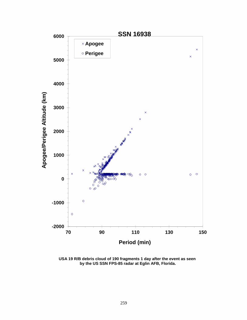
259
USA 19 R/B debris cloud of 190 fragments 1 day after the event as seen by the US SSN FPS-85 radar at Eglin AFB, Florida.
-2000
-1000
0
1000
2000
3000
4000
5000
6000
70 90 110 130 150
Apog
ee/P
erig
ee A
ltitu
de (k
m)
Period (min)
Apogee
Perigee
SSN 16938
260
COSMOS 1813 1987-004A 17297 SATELLITE DATA TYPE: Payload OWNER: CIS LAUNCH DATE: 15.47 Jan 1987 DRY MASS (KG): 6300 MAIN BODY: Sphere-cylinder; 2.4 m diameter by 6.5 m length MAJOR APPENDAGES: None ATTITUDE CONTROL: Active, 3-axis ENERGY SOURCES: On-board propellants, explosive charge EVENT DATA DATE: 29 Jan 1987 LOCATION: 73N, 122E (asc) TIME: 0555 GMT ASSESSED CAUSE: Deliberate ALTITUDE: 390 km PRE-EVENT ELEMENTS EPOCH: 87028.91020168 MEAN ANOMALY: 178.1696 RIGHT ASCENSION: 256.7724 MEAN MOTION: 15.60427146 INCLINATION: 72.8163 MEAN MOTION DOT/2: .00008569 ECCENTRICITY: .0043147 MEAN MOTION DOT DOT/6: .0 ARG. OF PERIGEE: 182.0100 BSTAR: .000099999 DEBRIS CLOUD DATA MAXIMUM ∆P: 9.1 min* MAXIMUM ∆I: 0.1 deg* *Based on PARCS observations COMMENTS Spacecraft apparently destroyed after a malfunction prevented controlled reentry and landing in the Soviet Union. A total of 846 separate fragments were observed during one pass over a U.S. Space Surveillance Network radar (PARCS) 2 days after the event. REFERENCE DOCUMENTS The Fragmentation of Kosmos 1813, R. L. Kling and J. S. Dowdy, Technical Report CS87-LKD-004, Teledyne Brown Engineering, Colorado Springs, 8 May 1987.
History of Soviet/Russian Satellite Fragmentations-A Joint U.S.-Russian Investigation, N. L. Johnson et al, Kaman Sciences Corporation, October 1995.
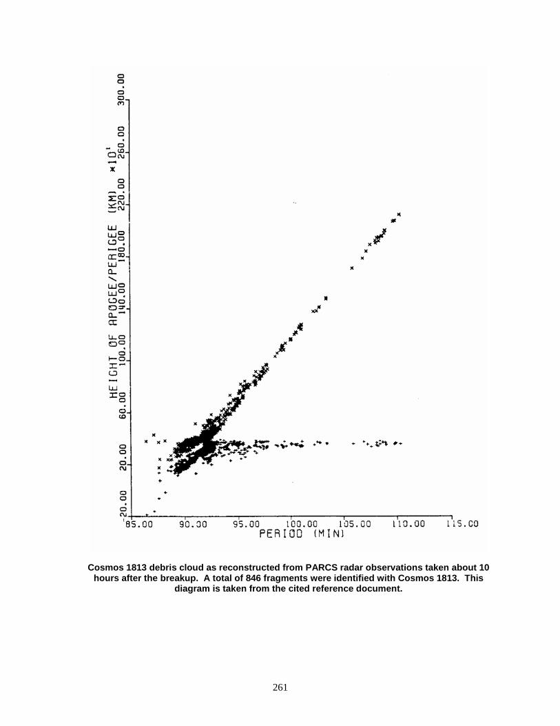
261
Cosmos 1813 debris cloud as reconstructed from PARCS radar observations taken about 10 hours after the breakup. A total of 846 fragments were identified with Cosmos 1813. This
diagram is taken from the cited reference document.

262
COSMOS 1823 1987-020A 17535 SATELLITE DATA TYPE: Payload OWNER: CIS LAUNCH DATE: 20.20 Feb 1987 DRY MASS (KG): 1500 MAIN BODY: Cylinder; 2.4 m diameter by 4 m length MAJOR APPENDAGES: Gravity-gradient boom; 10 small solar panels ATTITUDE CONTROL: Gravity gradient ENERGY SOURCES: Battery EVENT DATA DATE: 17 Dec 1987 LOCATION: 15S, 18E (dsc) TIME: 1739 GMT ASSESSED CAUSE: Battery ALTITUDE: 1485 km PRE-EVENT ELEMENTS EPOCH: 87351.61079422 MEAN ANOMALY: 147.6712 RIGHT ASCENSION: 184.5746 MEAN MOTION: 12.40947361 INCLINATION: 73.6064 MEAN MOTION DOT/2: .0 ECCENTRICITY: .0028819 MEAN MOTION DOT DOT/6: .0 ARG. OF PERIGEE: 212.2988 BSTAR: .0 DEBRIS CLOUD DATA MAXIMUM ∆P: 4.9 min MAXIMUM ∆I: 1.4 deg COMMENTS Cosmos 1823 has been acknowledged by the Soviet Union as a geodetic spacecraft, the eighth in a series that debuted in 1981. The spacecraft is known to have been operating 3 months before the event. USSR acknowledged mission termination as of 19 December 1987. Unusually strong radial velocity components are evident in cloud analyses over a period of many months. This event has been confirmed to be the third known failure of the NiH2 battery as reported by Dr. K. M. Suitashev at the February, 1992 Space Debris Conference held in Moscow. REFERENCE DOCUMENT History of Soviet/Russian Satellite Fragmentations-A Joint U.S.-Russian Investigation, N. L. Johnson et al, Kaman Sciences Corporation, October 1995.

263
Cosmos 1823 debris cloud of 165 fragments 2 weeks after the event as reconstructed from Naval Space Surveillance System database.
500
1000
1500
2000
2500
111 113 115 117 119 121
Apog
ee/P
erig
ee A
ltitu
de (k
m)
Period (min)
Apogee
Perigee
SSN 17535
264
COSMOS 1866 1987-059A 18184 SATELLITE DATA TYPE: Payload OWNER: CIS LAUNCH DATE: 9.67 Jul 1987 DRY MASS (KG): 5700 MAIN BODY: Cone-cylinder; 2.7 m diameter by 6.3 m length MAJOR APPENDAGES: Solar panels ATTITUDE CONTROL: Active, 3-axis ENERGY SOURCES: On-board propellants, explosive charge EVENT DATA DATE: 26 Jul 1987 LOCATION: 57S, 239E (asc) TIME: 1539 GMT ASSESSED CAUSE: Deliberate ALTITUDE: 245 km PRE-EVENT ELEMENTS EPOCH: 87207.60199851 MEAN ANOMALY: 300.9577 RIGHT ASCENSION: 98.7735 MEAN MOTION: 16.25421506 INCLINATION: 67.1494 MEAN MOTION DOT/2: .01099941 ECCENTRICITY: .0073576 MEAN MOTION DOT DOT/6: .000028662 ARG. OF PERIGEE: 61.7654 BSTAR: .00016423 DEBRIS CLOUD DATA MAXIMUM ∆P: 17.3 min MAXIMUM ∆I: 0.5 deg COMMENTS Spacecraft was destroyed after a malfunction prevented controlled reentry and landing in the Soviet Union. Hundreds of fragments were detected but most reentered before being officially cataloged. REFERENCE DOCUMENT History of Soviet/Russian Satellite Fragmentations-A Joint U.S.-Russian Investigation, N. L. Johnson et al, Kaman Sciences Corporation, October 1995.

265
Cosmos 1866 debris cloud of 27 fragments one to 2 days after the event as reconstructed from the US SSN database. Two fragments with orbital periods greater than 103 minutes
were cataloged in mid-August 1987.
0
200
400
600
800
1000
1200
85 90 95 100
Apog
ee/P
erig
ee A
ltitu
de (k
m)
Period (min)
Apogee
Perigee
SSN 18184
266
COSMOS 1869 1987-062A 18214 SATELLITE DATA TYPE: Payload OWNER: CIS LAUNCH DATE: 16.18 Jul 1987 DRY MASS (KG): 1900 MAIN BODY: Cylinder; 0.8-1.4 m diameter by 3 m length MAJOR APPENDAGES: Solar arrays, radar and other payload systems ATTITUDE CONTROL: Gravity gradient ENERGY SOURCES: Battery, pressurized vessels EVENT DATA DATE: 27 Nov 1997 LOCATION: Unknown TIME: 0006-0040 GMT? ASSESSED CAUSE: Unknown ALTITUDE: ∼630 km PRE-EVENT ELEMENTS EPOCH: 97329.88487815 MEAN ANOMALY: 245.1014 RIGHT ASCENSION: 97.7878 MEAN MOTION: 14.83337853 INCLINATION: 82.5131 MEAN MOTION DOT/2: 0.00000439 ECCENTRICITY: 0.0021357 MEAN MOTION DOT DOT/6: 0 ARG. OF PERIGEE: 115.2417 BSTAR: 0.000050420 DEBRIS CLOUD DATA MAXIMUM ∆P: Unknown MAXIMUM ∆I: Unknown COMMENTS Cosmos 1869 suffered a failure of its radar antenna to deploy immediately after launch. The spacecraft carried other optical sensors, but the vehicle appears to have become non-operational by 1988. At least 20 debris were detected. Virtually all the debris associated with the breakup event exhibited very large area-to-mass ratios, resulting in exceptionally rapid orbital decay. REFERENCE DOCUMENT “Recent Satellite Fragmentation Investigations”, N. Johnson, The Orbital Debris Quarterly News, NASA JSC, January 1998, p. 3. Available online at https://orbitaldebris.jsc.nasa.gov/quarterly-news/pdfs/ODQNv3i1.pdf.
267
Insufficient data to construct a Gabbard diagram.
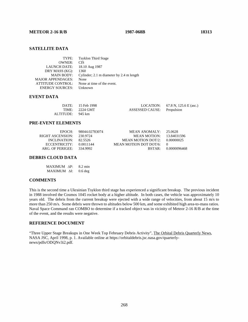
268
METEOR 2-16 R/B 1987-068B 18313 SATELLITE DATA TYPE: Tsyklon Third Stage OWNER: CIS LAUNCH DATE: 18.10 Aug 1987 DRY MASS (KG): 1360 MAIN BODY: Cylinder; 2.1 m diameter by 2.4 m length MAJOR APPENDAGES: None ATTITUDE CONTROL: None at time of the event. ENERGY SOURCES: Unknown EVENT DATA DATE: 15 Feb 1998 LOCATION: 67.8 N, 125.6 E (asc.) TIME: 2224 GMT ASSESSED CAUSE: Propulsion ALTITUDE: 945 km PRE-EVENT ELEMENTS EPOCH: 98044.02783074 MEAN ANOMALY: 25.0628 RIGHT ASCENSION: 230.9724 MEAN MOTION: 13.84031596 INCLINATION: 82.5526 MEAN MOTION DOT/2: 0.00000025 ECCENTRICITY: 0.0011144 MEAN MOTION DOT DOT/6: 0 ARG. OF PERIGEE: 334.9992 BSTAR: 0.0000096468 DEBRIS CLOUD DATA MAXIMUM ∆P: 8.2 min MAXIMUM ∆I: 0.6 deg COMMENTS This is the second time a Ukrainian Tsyklon third stage has experienced a significant breakup. The previous incident in 1988 involved the Cosmos 1045 rocket body at a higher altitude. In both cases, the vehicle was approximately 10 years old. The debris from the current breakup were ejected with a wide range of velocities, from about 15 m/s to more than 250 m/s. Some debris were thrown to altitudes below 500 km, and some exhibited high area-to-mass ratios. Naval Space Command ran COMBO to determine if a tracked object was in vicinity of Meteor 2-16 R/B at the time of the event, and the results were negative. REFERENCE DOCUMENT “Three Upper Stage Breakups in One Week Top February Debris Activity”, The Orbital Debris Quarterly News, NASA JSC, April 1998, p. 1. Available online at https://orbitaldebris.jsc.nasa.gov/quarterly-news/pdfs/ODQNv3i2.pdf.
269
Meteor 2-16 R/B debris cloud of 67 fragments 1 week after the event as reconstructed from the US SSN database.
0
200
400
600
800
1000
1200
1400
98 100 102 104 106 108
Apog
ee/P
erig
ee A
ltitu
de (k
m)
Period (min)
Apogee
Perigee
SSN 18313
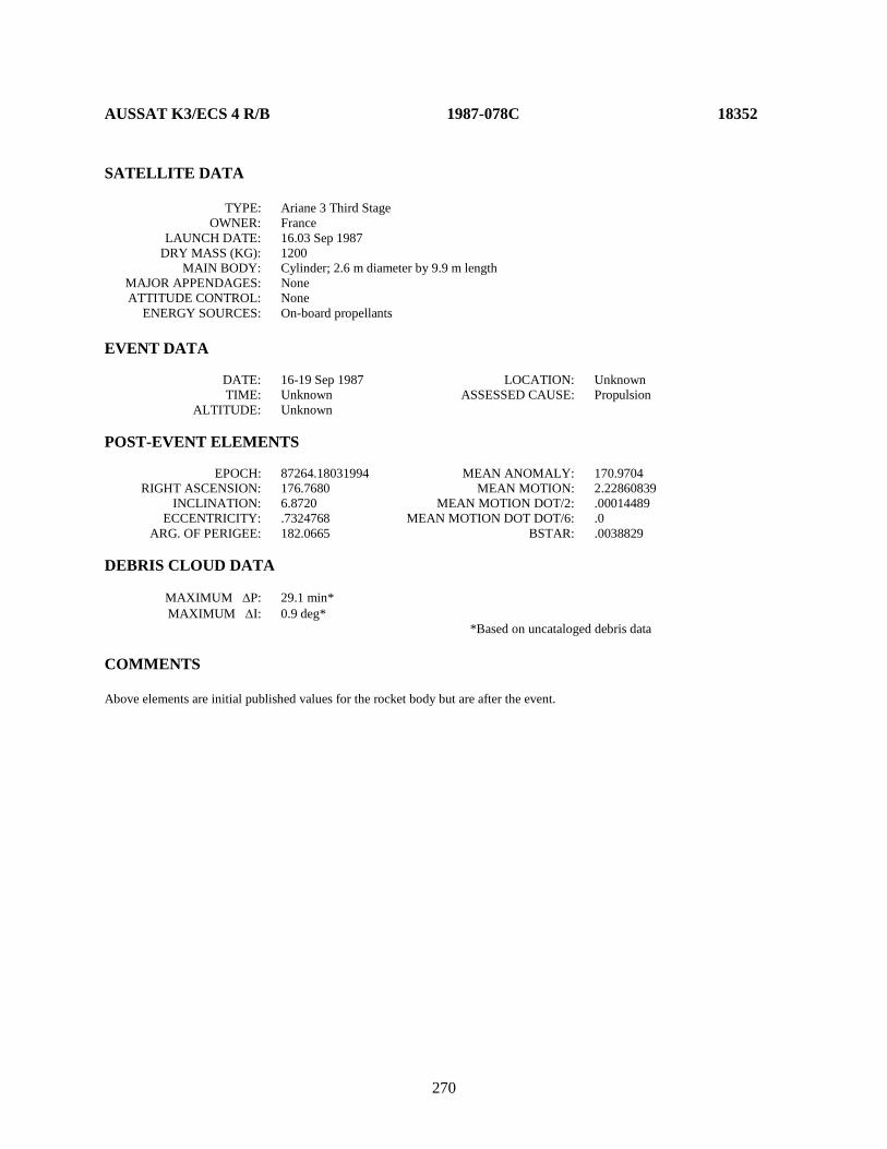
270
AUSSAT K3/ECS 4 R/B 1987-078C 18352 SATELLITE DATA TYPE: Ariane 3 Third Stage OWNER: France LAUNCH DATE: 16.03 Sep 1987 DRY MASS (KG): 1200 MAIN BODY: Cylinder; 2.6 m diameter by 9.9 m length MAJOR APPENDAGES: None ATTITUDE CONTROL: None ENERGY SOURCES: On-board propellants EVENT DATA DATE: 16-19 Sep 1987 LOCATION: Unknown TIME: Unknown ASSESSED CAUSE: Propulsion ALTITUDE: Unknown POST-EVENT ELEMENTS EPOCH: 87264.18031994 MEAN ANOMALY: 170.9704 RIGHT ASCENSION: 176.7680 MEAN MOTION: 2.22860839 INCLINATION: 6.8720 MEAN MOTION DOT/2: .00014489 ECCENTRICITY: .7324768 MEAN MOTION DOT DOT/6: .0 ARG. OF PERIGEE: 182.0665 BSTAR: .0038829 DEBRIS CLOUD DATA MAXIMUM ∆P: 29.1 min* MAXIMUM ∆I: 0.9 deg* *Based on uncataloged debris data COMMENTS Above elements are initial published values for the rocket body but are after the event.
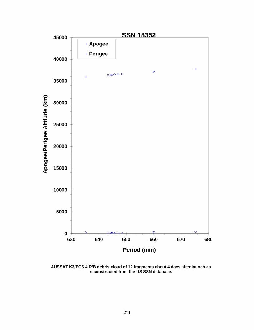
271
AUSSAT K3/ECS 4 R/B debris cloud of 12 fragments about 4 days after launch as reconstructed from the US SSN database.
0
5000
10000
15000
20000
25000
30000
35000
40000
45000
630 640 650 660 670 680
Apog
ee/P
erig
ee A
ltitu
de (k
m)
Period (min)
Apogee
Perigee
SSN 18352
272
COSMOS 1883-1885 ULLAGE MOTOR 1987-079G 18374 SATELLITE DATA TYPE: Mission Related Debris OWNER: CIS LAUNCH DATE: 16.12 Sep 1987 DRY MASS (KG): 55 MAIN BODY: Ellipsoid; 0.6 m diameter by 1 m length MAJOR APPENDAGES: None ATTITUDE CONTROL: None ENERGY SOURCES: On-board propellants EVENT DATA DATE: ∼ 01 December 1996 LOCATION: Unknown TIME: Unknown ASSESSED CAUSE: Propulsion ALTITUDE: Unknown PRE-EVENT ELEMENTS EPOCH: 96335.26612005 MEAN ANOMALY: 175.6198 RIGHT ASCENSION: 300.4954 MEAN MOTION: 4.24439384 INCLINATION: 64.9068 MEAN MOTION DOT/2: 0.00015773 ECCENTRICITY: 0.5826382 MEAN MOTION DOT DOT/6: 0 ARG. OF PERIGEE: 181.3565 BSTAR: 0 DEBRIS CLOUD DATA MAXIMUM ∆P: 234.1 min MAXIMUM ∆I: 2.6 deg COMMENTS This is the 14th event of this class identified to date. REFERENCE DOCUMENTS "Identification and Resolution of an Orbital Debris Problem with the Proton Launch Vehicle", Cherniatiev, Chernyavskiy, Johnson, and McKnight, First European Conference on Space Debris, 5-7 April 1993. "The Fragmentation of Proton Debris", Nauer, Teledyne Brown Engineering Technical Report CS93LKD-004, 31 December 1992. History of Soviet/Russian Satellite Fragmentations-A Joint U.S.-Russian Investigation, N. L. Johnson et al, Kaman Sciences Corporation, October 1995.
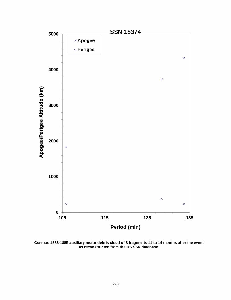
273
Cosmos 1883-1885 auxiliary motor debris cloud of 3 fragments 11 to 14 months after the event as reconstructed from the US SSN database.
0
1000
2000
3000
4000
5000
105 115 125 135
Apog
ee/P
erig
ee A
ltitu
de (k
m)
Period (min)
Apogee
Perigee
SSN 18374

274
COSMOS 1883-1885 ULLAGE MOTOR 1987-079H 18375 SATELLITE DATA TYPE: Mission Related Debris OWNER: CIS LAUNCH DATE: 16.12 Sep 1987 DRY MASS (KG): ~55 MAIN BODY: Ellipsoid; 0.6 m diameter by 1.0 m length MAJOR APPENDAGES: None ATTITUDE CONTROL: None ENERGY SOURCES: On-board propellants EVENT DATA DATE: 23 Apr 2003 LOCATION: Unknown TIME: ~1800Z ASSESSED CAUSE: Propulsion ALTITUDE: Unknown PRE-EVENT ELEMENTS EPOCH: 03113.46108488 MEAN ANOMALY: 332.8061 RIGHT ASCENSION: 156.9474 MEAN MOTION: 4.27871903 INCLINATION: 65.2438 MEAN MOTION DOT/2: .00000068 ECCENTRICITY: .5548829 MEAN MOTION DOT DOT/6: .0 ARG. OF PERIGEE: 85.3049 BSTAR: .00025672 DEBRIS CLOUD DATA MAXIMUM ∆P: 26.0 min* MAXIMUM ∆I: 1.19 deg* * Based on uncataloged debris data COMMENTS This event marks the 27th known breakup of a Proton Blok DM SOZ ullage motor since 1984. This ullage motor was launched before implementation of breakup preventive measures. 31 debris objects were cataloged from this breakup. REFERENCE DOCUMENT “Satellite Fragmentations in 2003”, The Orbital Debris Quarterly News, NASA JSC, January 2004. Available online at https://orbitaldebris.jsc.nasa.gov/quarterly-news/pdfs/ODQNv8i1.pdf.
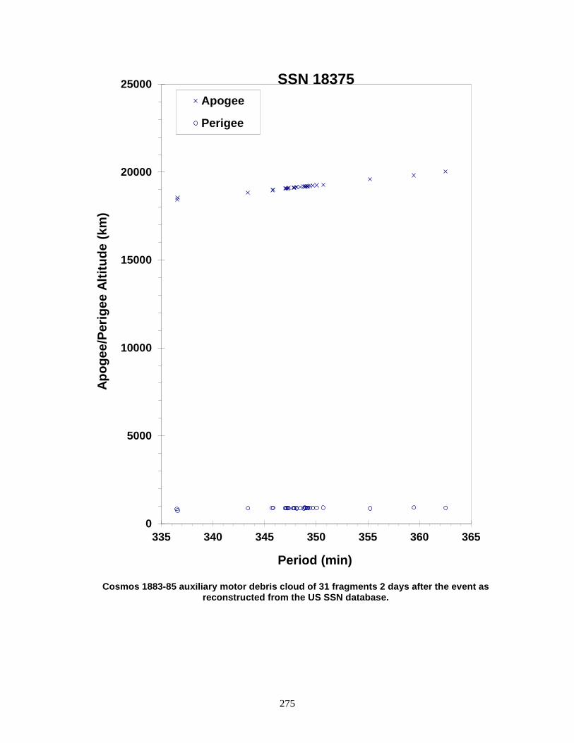
275
Cosmos 1883-85 auxiliary motor debris cloud of 31 fragments 2 days after the event as
reconstructed from the US SSN database.
0
5000
10000
15000
20000
25000
335 340 345 350 355 360 365
Apog
ee/P
erig
ee A
ltitu
de (k
m)
Period (min)
Apogee
Perigee
SSN 18375
276
COSMOS 1906 1987-108A 18713 SATELLITE DATA TYPE: Payload OWNER: CIS LAUNCH DATE: 26.48 Dec 1987 DRY MASS (KG): 6300 MAIN BODY: Sphere-Cylinder; 2.4 m diameter by 6.5 m length MAJOR APPENDAGES: Solar panels ATTITUDE CONTROL: Active, 3-axis ENERGY SOURCES: On-board propellants, explosive charge EVENT DATA DATE: 31 Jan 1988 LOCATION: 11S, 138E (dsc) TIME: 1109 GMT ASSESSED CAUSE: Deliberate ALTITUDE: 250 km PRE-EVENT ELEMENTS EPOCH: 88030.87152193 MEAN ANOMALY: 208.0352 RIGHT ASCENSION: 254.6565 MEAN MOTION: 16.07089398 INCLINATION: 82.5872 MEAN MOTION DOT/2: .00174892 ECCENTRICITY: .0015551 MEAN MOTION DOT DOT/6: .000012805 ARG. OF PERIGEE: 152.1926 BSTAR: .00022253 DEBRIS CLOUD DATA MAXIMUM ∆P: 5.7 min* MAXIMUM ∆I: 1.7 deg* *Based on cataloged and uncataloged debris data COMMENTS Spacecraft destroyed after a malfunction prevented controlled reentry and landing in the Soviet Union. Elements for 83 objects remaining in orbit about 10 days after the event were developed. Other debris reentered before being officially cataloged. REFERENCE DOCUMENTS The Soviet Year in Space 1988, N. L. Johnson, Teledyne Brown Engineering, 1989, p. 27. History of Soviet/Russian Satellite Fragmentations-A Joint U.S.-Russian Investigation, N. L. Johnson et al, Kaman Sciences Corporation, October 1995.
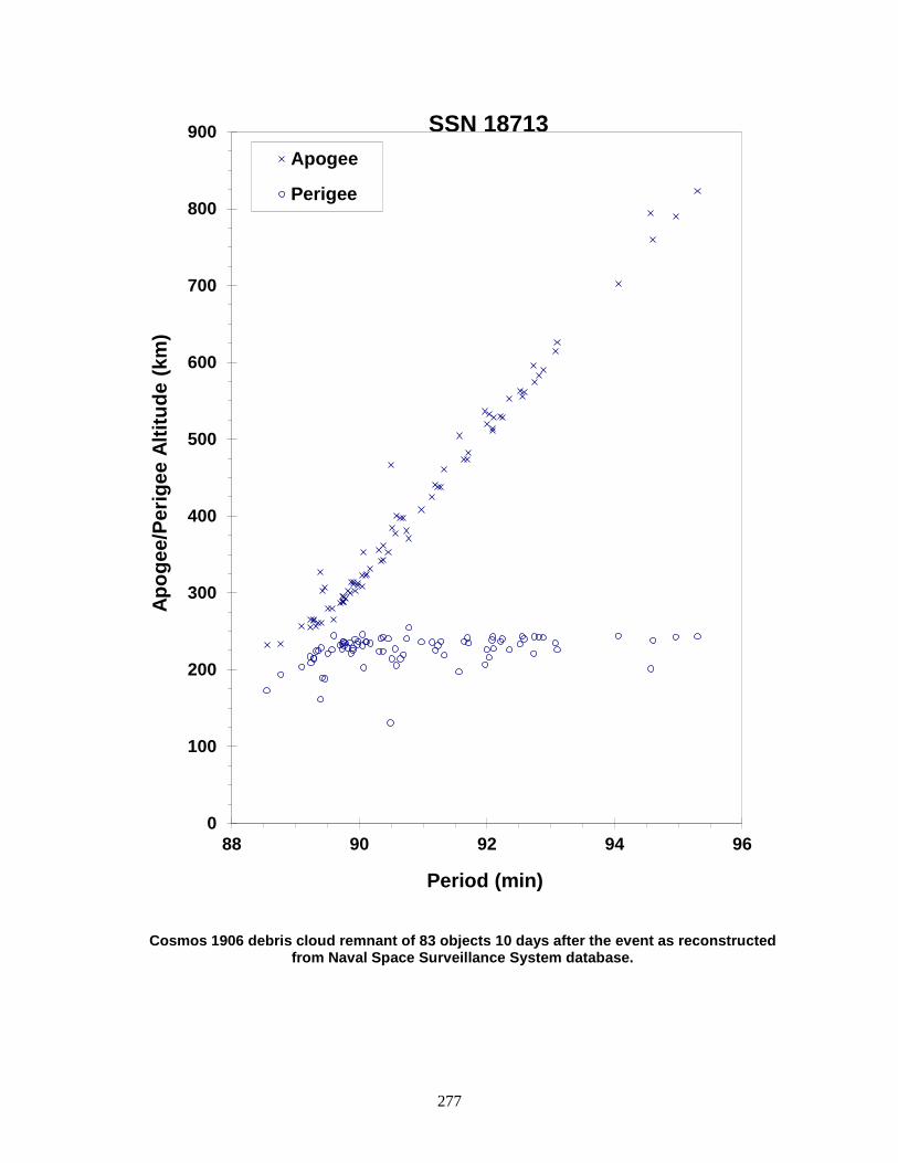
277
Cosmos 1906 debris cloud remnant of 83 objects 10 days after the event as reconstructed from Naval Space Surveillance System database.
0
100
200
300
400
500
600
700
800
900
88 90 92 94 96
Apog
ee/P
erig
ee A
ltitu
de (k
m)
Period (min)
Apogee
Perigee
SSN 18713

278
EKRAN 17 ULLAGE MOTOR 1987-109E 18719 SATELLITE DATA TYPE: Mission Related Debris OWNER: CIS LAUNCH DATE: 27.48 Dec 1987 DRY MASS (KG): 55 MAIN BODY: Ellipsoid; 0.6 m diameter by 1.0 m length MAJOR APPENDAGES: None ATTITUDE CONTROL: None at time of the event. ENERGY SOURCES: On-board propellants EVENT DATA DATE: 22 May 1997 LOCATION: Unknown TIME: Unknown ASSESSED CAUSE: Propulsion ALTITUDE: Unknown PRE-EVENT ELEMENTS EPOCH: 97141.34020043 MEAN ANOMALY: 1.8603 RIGHT ASCENSION: 253.0389 MEAN MOTION: 3.58845480 INCLINATION: 46.6273 MEAN MOTION DOT/2: -0.00000117 ECCENTRICITY: 0.6287941 MEAN MOTION DOT DOT/6: 0 ARG. OF PERIGEE: 349.7051 BSTAR: 0 DEBRIS CLOUD DATA MAXIMUM ∆P: Unknown MAXIMUM ∆I: Unknown COMMENTS This is the 15th event of this class identified to date. At least 72 debris were detected. REFERENCE DOCUMENTS “Three Satellite Breakups During May-June,” The Orbital Debris Quarterly News, NASA JSC, July 1997, p. 2. Available online at https://orbitaldebris.jsc.nasa.gov/quarterly-news/pdfs/ODQNv2i3.pdf. "Identification and Resolution of an Orbital Debris Problem with Proton Launch Vehicle", Cherniatiev, Chernyavskiy, Johnson, and McKnight, First European Conference on Space Debris, 5-7 April 1993. "The Fragmentation of Proton Debris", Nauer, Teledyne Brown Engineering Technical Report CS93-LKD-004, 31 Dec 1992. History of Soviet/Russian Satellite Fragmentations-A Joint U.S.-Russian Investigation, N. L. Johnson et al, Kaman Sciences Corporation, October 1995.

279
Insufficient data to construct a Gabbard diagram.
280
METEOR 2-17 1988-005A 18820 SATELLITE DATA TYPE: Payload OWNER: CIS LAUNCH DATE: 30.46 January 1988 DRY MASS (KG): 2750 MAIN BODY: Cylinder MAJOR APPENDAGES: Solar panels ATTITUDE CONTROL: none at time of event ENERGY SOURCES: unknown EVENT DATA DATE: 21 June 2005 LOCATION: 36.5N, 74.22E (asc) TIME: 09:14:54.5 GMT ASSESSED CAUSE: Unknown ALTITUDE: 954 km PRE-EVENT ELEMENTS EPOCH: 05171.27320873 MEAN ANOMALY: 320.4591 RIGHT ASCENSION: 309.0605 MEAN MOTION: 13.85140738 INCLINATION: 82.5393 MEAN MOTION DOT/2: .00000047 ECCENTRICITY: .0018107 MEAN MOTION DOT DOT/6: .0 ARG. OF PERIGEE: 39.7894 BSTAR: .000027897 DEBRIS CLOUD DATA MAXIMUM ∆P: 1.5 min MAXIMUM ∆I: 0.03 deg COMMENTS This meteorological spacecraft suffered both an anomalous event as well as a breakup event.
281
Meteor 2-17 debris cloud cataloged up to seven years after the event as reconstructed from the US SSN database.
282
DMSP 5D-2 F9 (USA 29) 1988-006A 18822 SATELLITE DATA TYPE: Payload OWNER: US LAUNCH DATE: 3.25 February 1988 DRY MASS (KG): 767 MAIN BODY: Cylinder; 1.0 m diameter by 3.6 m length MAJOR APPENDAGES: Solar panel and deployable instrumentation ATTITUDE CONTROL: none at time of event ENERGY SOURCES: unknown EVENT DATA DATE: 14-17 December 2012 LOCATION: Unknown TIME: Unknown ASSESSED CAUSE: Unknown ALTITUDE: Unknown PRE-EVENT ELEMENTS EPOCH: 12349.62481750 MEAN ANOMALY: 233.9639 RIGHT ASCENSION: 203.9910 MEAN MOTION: 14.26449692 INCLINATION: 98.8446 MEAN MOTION DOT/2: .00000181 ECCENTRICITY: .0006372 MEAN MOTION DOT DOT/6: .0 ARG. OF PERIGEE: 126.2134 BSTAR: .000094135 DEBRIS CLOUD DATA MAXIMUM ∆P: 1.3 min MAXIMUM ∆I: 0.2 deg COMMENTS Detected by software. DMSP 5D-2 F9 debris objects B-F are mission-related debris typical for this spacecraft series. Pieces G-N (SSN 39041-6 inclusive, 43329) appear to be relatively high area-to-mass objects, with only two of the seven objects (39046 and 43329) remaining on orbit as of 4 July 2018. This event may be similar in root cause to the F11 (USA 73) and F13 (USA 109) events.
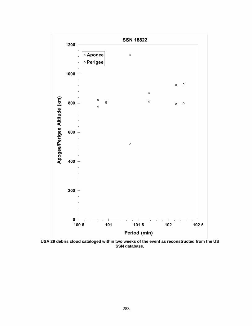
283
USA 29 debris cloud cataloged within two weeks of the event as reconstructed from the US
SSN database.
284
COSMOS 1916 1988-007A 18823 SATELLITE DATA TYPE: Payload OWNER: CIS LAUNCH DATE: 3.15 Feb 1988 DRY MASS (KG): 5700 MAIN BODY: Cone-cylinder; 2.7 m diameter by 6.3 m length MAJOR APPENDAGES: Solar panels ATTITUDE CONTROL: Active, 3-axis ENERGY SOURCES: On-board propellants, explosive charge EVENT DATA DATE: 27 Feb 1988 LOCATION: 62N, 98E (asc) TIME: 0444 GMT ASSESSED CAUSE: Deliberate ALTITUDE: 155 km PRE-EVENT ELEMENTS EPOCH: 88058.12322153 MEAN ANOMALY: 309.0154 RIGHT ASCENSION: 264.6529 MEAN MOTION: 16.30989909 INCLINATION: 64.8359 MEAN MOTION DOT/2: .03233928 ECCENTRICITY: .0060041 MEAN MOTION DOT DOT/6: .00003669 ARG. OF PERIGEE: 51.6410 BSTAR: .00025587 DEBRIS CLOUD DATA MAXIMUM ∆P: 4.2 min* MAXIMUM ∆I: 1.1 deg* *Based on uncataloged debris data COMMENTS Spacecraft destroyed after a malfunction prevented controlled reentry and landing in the Soviet Union. Early elements on only 6 objects available. All debris reentered before being officially cataloged. REFERENCE DOCUMENTS The Soviet Year in Space 1988, N. L. Johnson, Teledyne Brown Engineering, 1989, p. 31. History of Soviet/Russian Satellite Fragmentations-A Joint U.S.-Russian Investigation, N. L. Johnson et al, Kaman Sciences Corporation, October 1995.
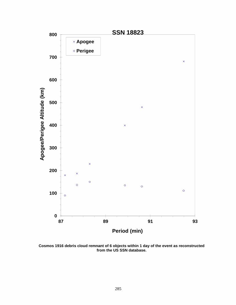
285
Cosmos 1916 debris cloud remnant of 6 objects within 1 day of the event as reconstructed from the US SSN database.
0
100
200
300
400
500
600
700
800
87 89 91 93
Apog
ee/P
erig
ee A
ltitu
de (k
m)
Period (min)
Apogee
Perigee
SSN 18823
286
COSMOS 1934 1988-023A 18985 SATELLITE DATA TYPE: Payload OWNER: CIS LAUNCH DATE: 22.59 Mar 1988 DRY MASS (KG): 800 MAIN BODY: Cylinder; 2.035 m diameter x 2 m length MAJOR APPENDAGES: Several short booms ATTITUDE CONTROL: Gravity-gradient (passive) ENERGY SOURCES: Batteries EVENT DATA DATE: 23 Dec 1991 LOCATION: Unknown TIME: Unknown ASSESSED CAUSE: Accidental Collision ALTITUDE: Unknown PRE-EVENT ELEMENTS EPOCH: 91356.93360267 MEAN ANOMALY: 291.3330 RIGHT ASCENSION: 126.2142 MEAN MOTION: 13.75709229 INCLINATION: 82.9564 MEAN MOTION DOT/2: 0.00000135 ECCENTRICITY: .0041502 MEAN MOTION DOT DOT/6: 0.0 ARG. OF PERIGEE: 69.2265 BSTAR: 0.00012752 DEBRIS CLOUD DATA MAXIMUM ∆P: Unknown MAXIMUM ∆I: Unknown COMMENTS The collision occurred with a piece of launch debris from Cosmos 926. The debris piece (Sat. No. 13475) was evidently shattered into smaller, non-trackable debris by the impact and the public satellite catalog now notes that it “COLLIDED WITH SATELLITE” in lieu of the standard orbital elements. There were several very close conjunctions during the day in question, the exact time of the collision is unknown. Two pieces of debris were cataloged from the event long before the event was recognized as a collision. REFERENCE DOCUMENT “Accidental Collisions of Cataloged Satellites Identified”, The Orbital Debris Quarterly News, NASA JSC, April 2005. Available online at https://orbitaldebris.jsc.nasa.gov/quarterly-news/pdfs/ODQNv9i2.pdf.

287
Insufficient data to construct a Gabbard diagram.
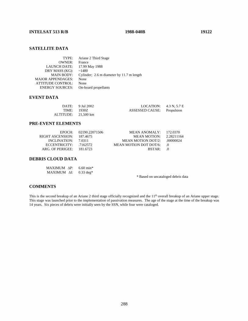
288
INTELSAT 513 R/B 1988-040B 19122 SATELLITE DATA TYPE: Ariane 2 Third Stage OWNER: France LAUNCH DATE: 17.99 May 1988 DRY MASS (KG): ~1480 MAIN BODY: Cylinder; 2.6 m diameter by 11.7 m length MAJOR APPENDAGES: None ATTITUDE CONTROL: None ENERGY SOURCES: On-board propellants EVENT DATA DATE: 9 Jul 2002 LOCATION: 4.3 N, 5.7 E TIME: 1930Z ASSESSED CAUSE: Propulsion ALTITUDE: 21,500 km PRE-EVENT ELEMENTS EPOCH: 02190.22071506 MEAN ANOMALY: 172.0370 RIGHT ASCENSION: 187.4675 MEAN MOTION: 2.28211164 INCLINATION: 7.0311 MEAN MOTION DOT/2: .00000024 ECCENTRICITY: .7162572 MEAN MOTION DOT DOT/6: .0 ARG. OF PERIGEE: 181.6723 BSTAR: .0 DEBRIS CLOUD DATA MAXIMUM ∆P: 6.60 min* MAXIMUM ∆I: 0.33 deg* * Based on uncataloged debris data COMMENTS This is the second breakup of an Ariane 2 third stage officially recognized and the 11th overall breakup of an Ariane upper stage. This stage was launched prior to the implementation of passivation measures. The age of the stage at the time of the breakup was 14 years. Six pieces of debris were initially seen by the SSN, while four were cataloged.
289
Intelsat 513 R/B debris cloud of 6 fragments 2 weeks after the breakup as reconstructed from
the US SSN database.
0
5000
10000
15000
20000
25000
30000
35000
40000
45000
630 632 634 636 638
Apog
ee/P
erig
ee A
ltitu
de (k
m)
Period (min)
Apogee
Perigee
SSN 19122

290
COSMOS 1970-1972 ULLAGE MOTOR 1988-085F 19535 SATELLITE DATA TYPE: Mission Related Debris OWNER: CIS LAUNCH DATE: 16.08 Sep 1988 DRY MASS (KG): ~55 MAIN BODY: Ellipsoid; 0.6 m diameter by 1.0 m length MAJOR APPENDAGES: None ATTITUDE CONTROL: None ENERGY SOURCES: On-board propellants EVENT DATA DATE: 04 Aug 2003 LOCATION: Unknown TIME: ~0725Z ASSESSED CAUSE: Propulsion ALTITUDE: Unknown PRE-EVENT ELEMENTS EPOCH: 03214.47923598 MEAN ANOMALY: 334.9286 RIGHT ASCENSION: 239.4643 MEAN MOTION: 4.29128214 INCLINATION: 65.3341 MEAN MOTION DOT/2: .00007107 ECCENTRICITY: .5561230 MEAN MOTION DOT DOT/6: .0 ARG. OF PERIGEE: 85.1870 BSTAR: .071402 DEBRIS CLOUD DATA MAXIMUM ∆P: 18.8 min* MAXIMUM ∆I: 2.79 deg* * Based on uncataloged debris data COMMENTS This event marks the 28th known breakup of a Proton Block DM SOZ ullage motor since 1984. This ullage motor was launched before implementation of breakup preventive measures. Approximately 175 objects were initially seen by the SSN 1 week after the event. 76 debris objects were cataloged. REFERENCE DOCUMENT “Satellite Fragmentations in 2003”, The Orbital Debris Quarterly News, NASA JSC, January 2004. Available online at https://orbitaldebris.jsc.nasa.gov/quarterly-news/pdfs/ODQNv8i1.pdf.

291
Cosmos 1970-72 auxiliary motor debris cloud of 175 fragments 1 week after the event as
reconstructed from the US SSN database.
0
5000
10000
15000
20000
25000
320 325 330 335 340 345 350
Apog
ee/P
erig
ee A
ltitu
de (k
m)
Period (min)
Apogee
Perigee
SSN 19535
292
COSMOS 1970-1972 ULLAGE MOTOR 1988-085G 19537 SATELLITE DATA TYPE: Mission Related Debris OWNER: CIS LAUNCH DATE: 16 Sep 1988 DRY MASS (KG): 55 MAIN BODY: Ellipsoid; 0.6 m diameter by 1.0 m length MAJOR APPENDAGES: None ATTITUDE CONTROL: None ENERGY SOURCES: On-board propellants EVENT DATA DATE: 9 Mar 1999 LOCATION: Unknown TIME: Unknown ASSESSED CAUSE: Propulsion ALTITUDE: Unknown POST-EVENT ELEMENTS EPOCH: 99067.36656961 MEAN ANOMALY: 189.8576 RIGHT ASCENSION: 108.7309 MEAN MOTION: 4.28860956162171 INCLINATION: 64.6425 MEAN MOTION DOT/2: .00000813 ECCENTRICITY: .5827119 MEAN MOTION DOT DOT/6: 00000-0 ARG. OF PERIGEE: 176.8483 BSTAR: .0022335 DEBRIS CLOUD DATA MAXIMUM ∆P: Unknown MAXIMUM ∆I: Unknown COMMENTS This is the 19th event of the Proton Block DM SOZ Ullage Motor class identified to date; it is the eighth associated with a GLONASS mission. This mission was conducted before the engineering defect was identified and passivation measures implemented. In this highly-eccentric orbit, debris may be long-lived but hard to track. 17 debris objects were detected. REFERENCE DOCUMENT “Abandoned Proton Ullage Motors Continue to Create Debris”, The Orbital Debris Quarterly News, NASA JSC, April 1999. Available online at https://orbitaldebris.jsc.nasa.gov/quarterly-news/pdfs/ODQNv4i2.pdf.

293
Insufficient data to construct a Gabbard diagram.

294
SKYNET 4B/ASTRA 1A R/B 1988-109C 19689 SATELLITE DATA TYPE: Ariane 4 H-10 Third Stage OWNER: France LAUNCH DATE: 11.02 Dec 1988 DRY MASS (KG): 1760 MAIN BODY: Cylinder; 2.6 m diameter by 11.4 m length MAJOR APPENDAGES: None ATTITUDE CONTROL: None at time of the event. ENERGY SOURCES: On-board propellants EVENT DATA DATE: 17 Feb 1998 LOCATION: 6.9 N, 157.2 E (dsc) TIME: 1235 GMT ASSESSED CAUSE: Propulsion ALTITUDE: 19630 km PRE-EVENT ELEMENTS EPOCH: 98047.29326560 MEAN ANOMALY: 25.3394 RIGHT ASCENSION: 23.7998 MEAN MOTION: 2.25942020 INCLINATION: 7.3381 MEAN MOTION DOT/2: 0.00000046 ECCENTRICITY: 0.7222736 MEAN MOTION DOT DOT/6: 0 ARG. OF PERIGEE: 248.1711 BSTAR: 0.00057969 DEBRIS CLOUD DATA MAXIMUM ∆P: Unknown MAXIMUM ∆I: Unknown COMMENTS This mission was the second for the Ariane 4 series and occurred prior to implementation of passivation measures. Using observations from the Eglin radar, specialists at Millstone radar found four new pieces from the upper stage. Naval Space Command personnel generated the first two debris element sets and calculated the approximate breakup time noted above. REFERENCE DOCUMENT “Three Upper Stage Breakups in One Week Top February Debris Activity”, The Orbital Debris Quarterly News, NASA JSC, April 1998, p. 1. Available online at https://orbitaldebris.jsc.nasa.gov/quarterly-news/pdfs/ODQNv3i2.pdf.

295
Insufficient data to construct a Gabbard diagram.
296
COSMOS 1987-1989 ULLAGE MOTOR 1989-001G 19755 SATELLITE DATA TYPE: Mission Related Debris OWNER: CIS LAUNCH DATE: 10 Jan 1989 DRY MASS (KG): 55 MAIN BODY: Ellipsoid; 0.6 m diameter by 1 m length MAJOR APPENDAGES: None ATTITUDE CONTROL: None ENERGY SOURCES: On-board propellants EVENT DATA DATE: 3 Aug 1998 LOCATION: Unknown TIME: Unknown ASSESSED CAUSE: Propulsion ALTITUDE: Unknown POST-EVENT ELEMENTS EPOCH: 98211.80543118 MEAN ANOMALY: 172.2753 RIGHT ASCENSION: 16.7694 MEAN MOTION: 4.24137167 INCLINATION: 64.9243 MEAN MOTION DOT/2: .00000287 ECCENTRICITY: .5776927 MEAN MOTION DOT DOT/6: 00000-0 ARG. OF PERIGEE: 182.6029 BSTAR: .0041366 DEBRIS CLOUD DATA MAXIMUM ∆P: 162.64 min MAXIMUM ∆I: 3.78 deg COMMENTS This is the 17th event of the Proton Block DM SOZ Ullage Motor class identified to date; it is the sixth associated with a GLONASS mission. This mission was conducted before the engineering defect was identified and passivation measures implemented. In this orbit, debris may be long-lived but hard to track. More than 110 debris objects were detected. REFERENCE DOCUMENT “Solitary Breakup and Anomalous Events in Third Quarter are Familiar”, The Orbital Debris Quarterly News, NASA JSC, October 1998. Available online at: https://orbitaldebris.jsc.nasa.gov/quarterly-news/pdfs/ODQNv3i4.pdf.
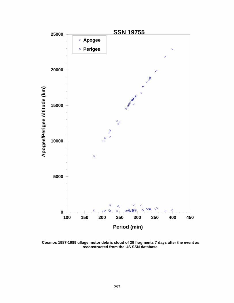
297
Cosmos 1987-1989 ullage motor debris cloud of 39 fragments 7 days after the event as reconstructed from the US SSN database.
0
5000
10000
15000
20000
25000
100 150 200 250 300 350 400 450
Apog
ee/P
erig
ee A
ltitu
de (k
m)
Period (min)
Apogee
Perigee
SSN 19755

298
COSMOS 1987-1989 ULLAGE MOTOR 1989-001H 19856 SATELLITE DATA TYPE: Mission Related Debris OWNER: CIS LAUNCH DATE: 10 Jan 1989 DRY MASS (KG): ~55 MAIN BODY: Ellipsoid; 0.6 m diameter by 1.0 m length MAJOR APPENDAGES: None ATTITUDE CONTROL: None ENERGY SOURCES: On-board propellants EVENT DATA DATE: 13 Nov 2003 LOCATION: Unknown TIME: Unknown ASSESSED CAUSE: Propulsion ALTITUDE: Unknown PRE-EVENT ELEMENTS EPOCH: 03317.76135862 MEAN ANOMALY: 339.1502 RIGHT ASCENSION: 52.9695 MEAN MOTION: 4.24824637 INCLINATION: 65.4357 MEAN MOTION DOT/2: .00000161 ECCENTRICITY: .5599025 MEAN MOTION DOT DOT/6: .0 ARG. OF PERIGEE: 72.44443 BSTAR: .0017638 DEBRIS CLOUD DATA MAXIMUM ∆P: Unknown MAXIMUM ∆I: Unknown COMMENTS This event marks the 29th known breakup of a Proton Block DM SOZ ullage motor since 1984, although the event went undetected for over 3 months. This ullage motor was launched before implementation of breakup preventive measures. No debris objects were cataloged from this breakup.

299
Insufficient data to construct a Gabbard diagram.
300
GORIZONT 17 ULLAGE MOTOR 1989-004E 19771 SATELLITE DATA TYPE: Mission Related Debris OWNER: CIS LAUNCH DATE: 26.39 Jan 1989 DRY MASS (KG): 55 MAIN BODY: Ellipsoid; 0.6 m diameter by 1 m diameter MAJOR APPENDAGES: None ATTITUDE CONTROL: None ENERGY SOURCES: On-board propellants EVENT DATA DATE: 17-18 Dec 1992 LOCATION: Unknown TIME: Unknown ASSESSED CAUSE: Propulsion ALTITUDE: Unknown PRE-EVENT ELEMENTS EPOCH: 92351.90838995 MEAN ANOMALY: 1.4295 RIGHT ASCENSION: 266.2338 MEAN MOTION: 4.60309514 INCLINATION: 46.7001 MEAN MOTION DOT/2: .00060784 ECCENTRICITY: .5692927 MEAN MOTION DOT DOT/6: .0000093219 ARG. OF PERIGEE: 353.9854 BSTAR: .0015056 DEBRIS CLOUD DATA MAXIMUM ∆P: Unknown MAXIMUM ∆I: Unknown COMMENTS Parent satellite was one of two small engine units that are routinely released after the first burn of the Proton fourth stage. The nature of these objects was identified by Dr. Boris V. Chernlatiev, Deputy Constructor for the Energiya NPO, in October 1992. The cause of this fragmentation is assumed to be related to the residual hypergolic propellants on board and failure of the membrane separating the fuel and oxidizer. NAVSPASUR observed between 30-40 objects that were associated with this breakup. Only 4 element sets were generated, insufficient for a Gabbard Diagram or BLAST point. This was the seventh in a series of fragmentations of this object type, and was the second located in a geosynchronous transfer orbit. REFERENCE DOCUMENTS The Fragmentation of Proton Debris, D. J. Nauer, TBE Technical Report CS93-LKD-004, Teledyne Brown Engineering, Colorado Springs, 31 December 1992. Analysis of Fragmentations From December 1992 - February 1993, TBE Technical Report CS93-LKD-010, Teledyne Brown Engineering, Colorado Springs, 30 March 1993. History of Soviet/Russian Satellite Fragmentations-A Joint U.S.-Russian Investigation, N. L. Johnson et al, Kaman Sciences Corporation, October 1995. “Identification and Resolution of an Orbital Debris Problem with the Proton Launch Vehicle”, B. V. Cherniatiev et al, Proceedings of the First European Conference on Space Debris, April 1993.

301
Insufficient data to construct a Gabbard diagram.
302
ARIANE 2 R/B 1989-006B 19773 SATELLITE DATA TYPE: Ariane 2 third stage with VEB OWNER: France LAUNCH DATE: 27.06 Jan 1989 DRY MASS (KG): ~1480 kg MAIN BODY: 2.6 m diameter by 11.7 m length MAJOR APPENDAGES: None ATTITUDE CONTROL: None ENERGY SOURCES: On-board propellants? EVENT DATA DATE: ~1 Jan 2001 LOCATION: Unknown TIME: Unknown ASSESSED CAUSE: Propulsion ALTITUDE: Unknown PRE-EVENT ELEMENTS EPOCH: 00366.06151127 MEAN ANOMALY: 45.8970 RIGHT ASCENSION: 73.3900 MEAN MOTION: 2.26500973 INCLINATION: 8.3781 MEAN MOTION DOT/2: .00000580 ECCENTRICITY: .7188412 MEAN MOTION DOT DOT/6: .0000000 ARG. OF PERIGEE: 225.8250 BSTAR: .0040973 DEBRIS CLOUD DATA MAXIMUM ∆P: Unknown* MAXIMUM ∆I: Unknown* * Not calculated due to provisional nature of orbital data at event time. COMMENTS This is the first breakup of an Ariane 2 third stage officially recognized. One Ariane 3 third stage (same as Ariane 2) is known to have broken-up within a few days of launch in 1987. Both vehicles were launched before passivation measures were incorporated with Ariane third stages. Ariane third stage passivation was introduced in January 1990 and has been employed on all Ariane missions since October 1993. The age of the Ariane 2 third stage at the time of the breakup was nearly 12 years.
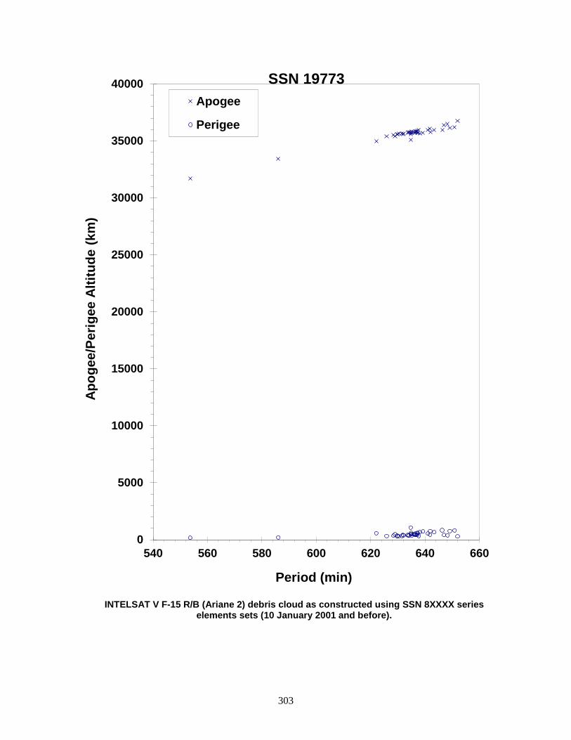
303
INTELSAT V F-15 R/B (Ariane 2) debris cloud as constructed using SSN 8XXXX series
elements sets (10 January 2001 and before).
0
5000
10000
15000
20000
25000
30000
35000
40000
540 560 580 600 620 640 660
Apog
ee/P
erig
ee A
ltitu
de (k
m)
Period (min)
Apogee
Perigee
SSN 19773
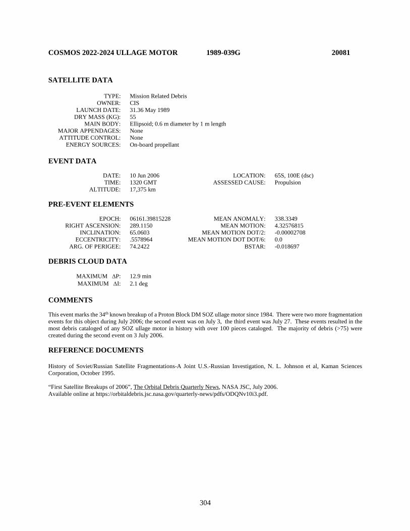
304
COSMOS 2022-2024 ULLAGE MOTOR 1989-039G 20081 SATELLITE DATA TYPE: Mission Related Debris OWNER: CIS LAUNCH DATE: 31.36 May 1989 DRY MASS (KG): 55 MAIN BODY: Ellipsoid; 0.6 m diameter by 1 m length MAJOR APPENDAGES: None ATTITUDE CONTROL: None ENERGY SOURCES: On-board propellant EVENT DATA DATE: 10 Jun 2006 LOCATION: 65S, 100E (dsc) TIME: 1320 GMT ASSESSED CAUSE: Propulsion ALTITUDE: 17,375 km PRE-EVENT ELEMENTS EPOCH: 06161.39815228 MEAN ANOMALY: 338.3349 RIGHT ASCENSION: 289.1150 MEAN MOTION: 4.32576815 INCLINATION: 65.0603 MEAN MOTION DOT/2: -0.00002708 ECCENTRICITY: .5578964 MEAN MOTION DOT DOT/6: 0.0 ARG. OF PERIGEE: 74.2422 BSTAR: -0.018697 DEBRIS CLOUD DATA MAXIMUM ∆P: 12.9 min MAXIMUM ∆I: 2.1 deg COMMENTS This event marks the 34th known breakup of a Proton Block DM SOZ ullage motor since 1984. There were two more fragmentation events for this object during July 2006; the second event was on July 3, the third event was July 27. These events resulted in the most debris cataloged of any SOZ ullage motor in history with over 100 pieces cataloged. The majority of debris (>75) were created during the second event on 3 July 2006. REFERENCE DOCUMENTS History of Soviet/Russian Satellite Fragmentations-A Joint U.S.-Russian Investigation, N. L. Johnson et al, Kaman Sciences Corporation, October 1995. “First Satellite Breakups of 2006”, The Orbital Debris Quarterly News, NASA JSC, July 2006. Available online at https://orbitaldebris.jsc.nasa.gov/quarterly-news/pdfs/ODQNv10i3.pdf.
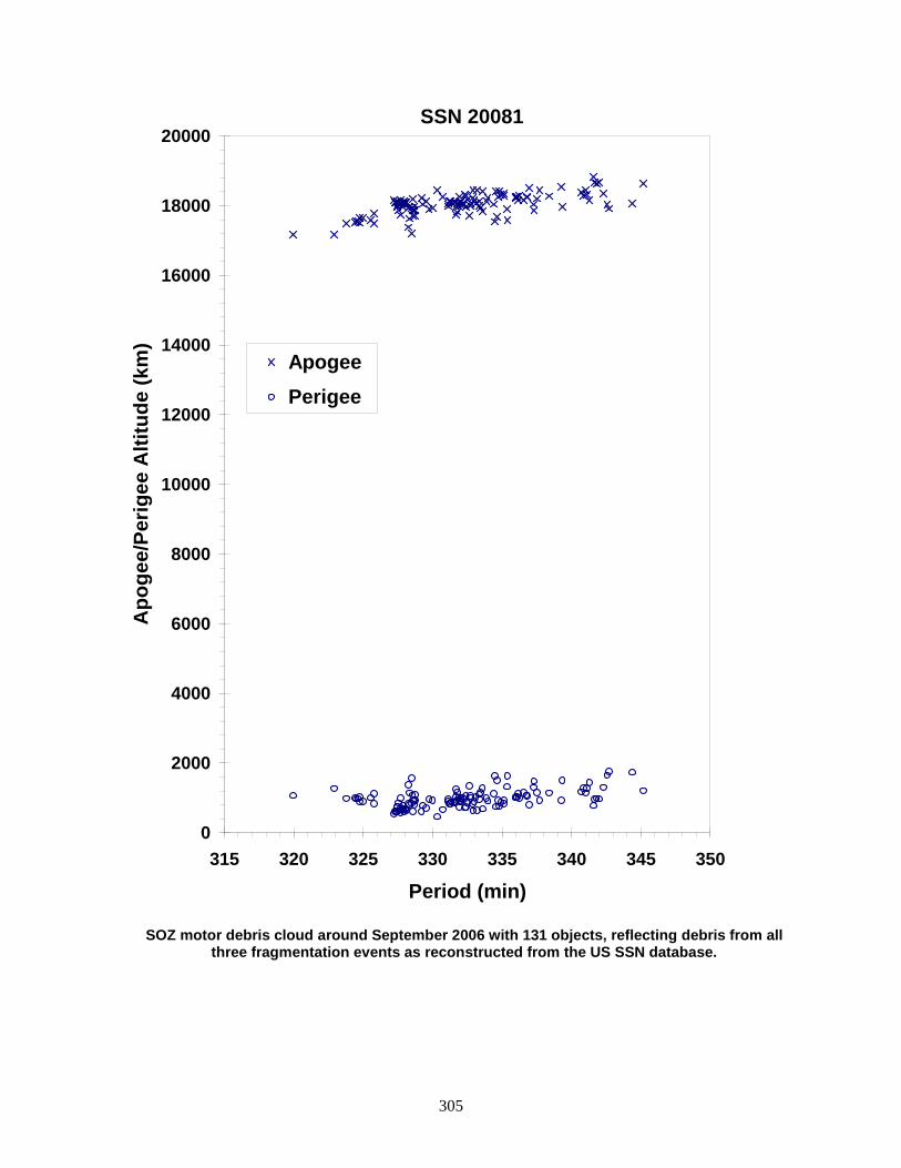
305
SOZ motor debris cloud around September 2006 with 131 objects, reflecting debris from all
three fragmentation events as reconstructed from the US SSN database.
0
2000
4000
6000
8000
10000
12000
14000
16000
18000
20000
315 320 325 330 335 340 345 350
Period (min)
Apo
gee/
Perig
ee A
ltitu
de (k
m)
Apogee Perigee
SSN 20081

306
GORIZONT 18 ULLAGE MOTOR 1989-052F 20116 SATELLITE DATA TYPE: Mission Related Debris OWNER: CIS LAUNCH DATE: 5.95 Jul 1989 DRY MASS (KG): 55 MAIN BODY: Ellipsoid; 0.6 m diameter by 1 m length MAJOR APPENDAGES: None ATTITUDE CONTROL: None ENERGY SOURCES: On-board propellants EVENT DATA DATE: 12 Jan 1993 LOCATION: Unknown TIME: Unknown ASSESSED CAUSE: Propulsion ALTITUDE: Unknown PRE-EVENT ELEMENTS EPOCH: 93004.96424013 MEAN ANOMALY: 353.7659 RIGHT ASCENSION: 215.2912 MEAN MOTION: 2.68234049 INCLINATION: 46.7556 MEAN MOTION DOT/2: .00007021 ECCENTRICITY: .6967354 MEAN MOTION DOT DOT/6: .0 ARG. OF PERIGEE: 45.1358 BSTAR: .0017532 DEBRIS CLOUD DATA MAXIMUM ∆P: Unknown MAXIMUM ∆I: Unknown COMMENTS Parent satellite was one of two small engine units that are routinely released after the first burn of the Proton fourth stage. The nature of these objects was identified by Dr. Boris V. Chernlatiev, Deputy Constructor for the Energiya NPO, in October 1992. The cause of this fragmentation is assumed to be related to the residual hypergolic propellants on board and failure of the membrane separating the fuel and oxidizer. NAVSPASUR observed 18 objects that were associated with this breakup. Only 5 element sets were generated, and were of insufficient quality for a credible Gabbard Diagram or BLAST point. This was the eighth in a series of fragmentations of this object type, and was the third located in a geosynchronous transfer orbit. REFERENCE DOCUMENTS The Fragmentation of Proton Debris, D. J. Nauer, TBE Technical Report CS93-LKD-004, Teledyne Brown Engineering, Colorado Springs, 31 December 1992. Analysis of Fragmentations From December 1992 - February 1993, TBE Technical Report CS93-LKD-010, Teledyne Brown Engineering, Colorado Springs, 30 March 1993. History of Soviet/Russian Satellite Fragmentations-A Joint U.S.-Russian Investigation, N. L. Johnson et al, Kaman Sciences Corporation, October 1995. “Identification and Resolution of an Orbital Debris Problem with the Proton Launch Vehicle”, B. V. Cherniatiev et al, Proceedings of the First European Conference on Space Debris, April 1993.

307
Insufficient data to construct a Gabbard diagram.
308
COSMOS 2030 1989-054A 20124 SATELLITE DATA TYPE: Payload OWNER: CIS LAUNCH DATE: 12.63 Jul 1989 DRY MASS (KG): 5700 MAIN BODY: Cone-cylinder; 2.7 m diameter by 6.3 m length MAJOR APPENDAGES: Solar panels ATTITUDE CONTROL: Active, 3-axis ENERGY SOURCES: On-board propellants, explosive charge EVENT DATA DATE: 28 Jul 1989 LOCATION: 35-65N, 95-140E (asc) TIME: 0410-0420 GMT ASSESSED CAUSE: Deliberate ALTITUDE: 150 km PRE-EVENT ELEMENTS EPOCH: 89208.98384568 MEAN ANOMALY: 302.7810 RIGHT ASCENSION: 89.7470 MEAN MOTION: 16.33519268 INCLINATION: 67.1441 MEAN MOTION DOT/2: .03079561 ECCENTRICITY: .0048139 MEAN MOTION DOT DOT/6: .000029506 ARG. OF PERIGEE: 57.9032 BSTAR: .00023479 DEBRIS CLOUD DATA MAXIMUM ∆P: 7.1 min* MAXIMUM ∆I: 1.3 deg* *Based on uncataloged debris data COMMENTS Spacecraft was destroyed after a malfunction prevented controlled reentry and landing in the Soviet Union. Early element sets on only 20 objects available. Rapid decay of objects made calculation of breakup time and location difficult. REFERENCE DOCUMENTS The Fragmentation of Kosmos 2030, N. L. Johnson, Technical Report CS89-TR-JSC-002, Teledyne Brown Engineering, Colorado Springs, Colorado, September 1989. History of Soviet/Russian Satellite Fragmentations-A Joint U.S.-Russian Investigation, N. L. Johnson et al, Kaman Sciences Corporation, October 1995.
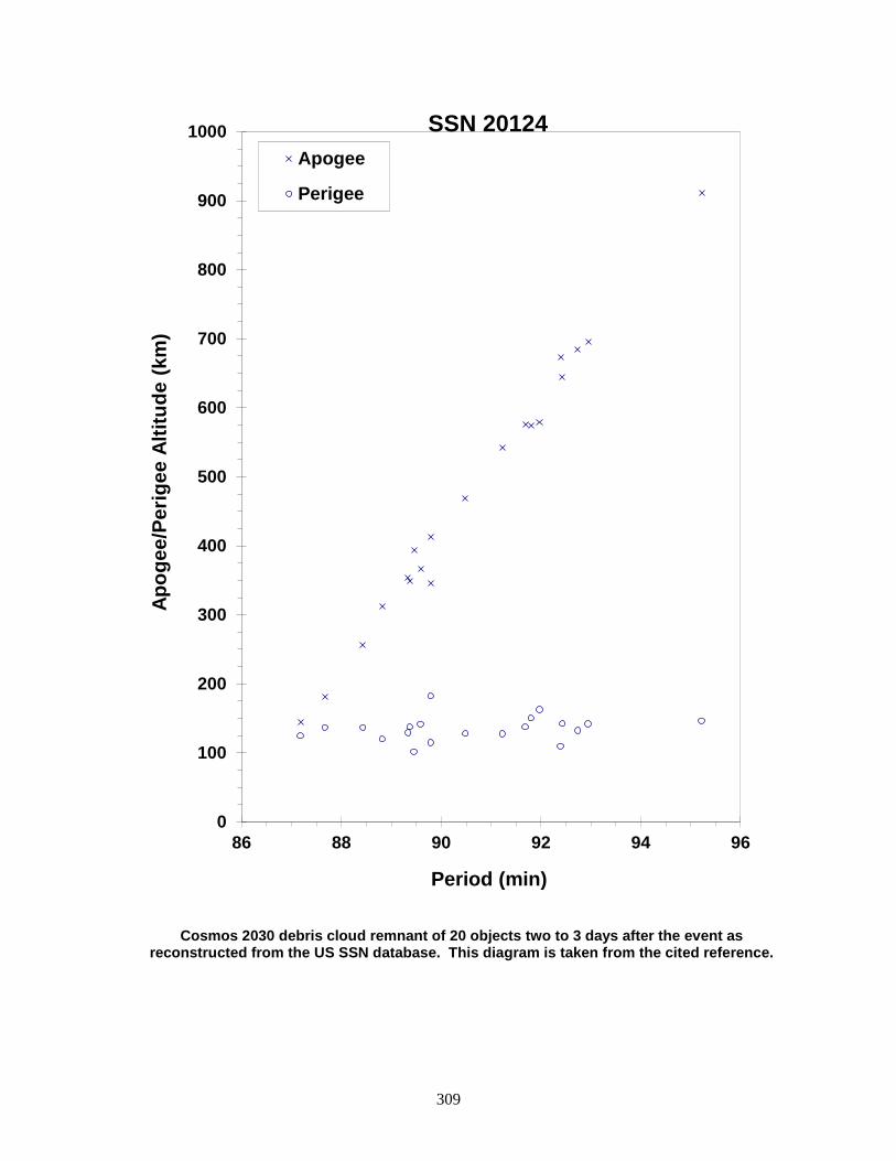
309
Cosmos 2030 debris cloud remnant of 20 objects two to 3 days after the event as reconstructed from the US SSN database. This diagram is taken from the cited reference.
0
100
200
300
400
500
600
700
800
900
1000
86 88 90 92 94 96
Apog
ee/P
erig
ee A
ltitu
de (k
m)
Period (min)
Apogee
Perigee
SSN 20124
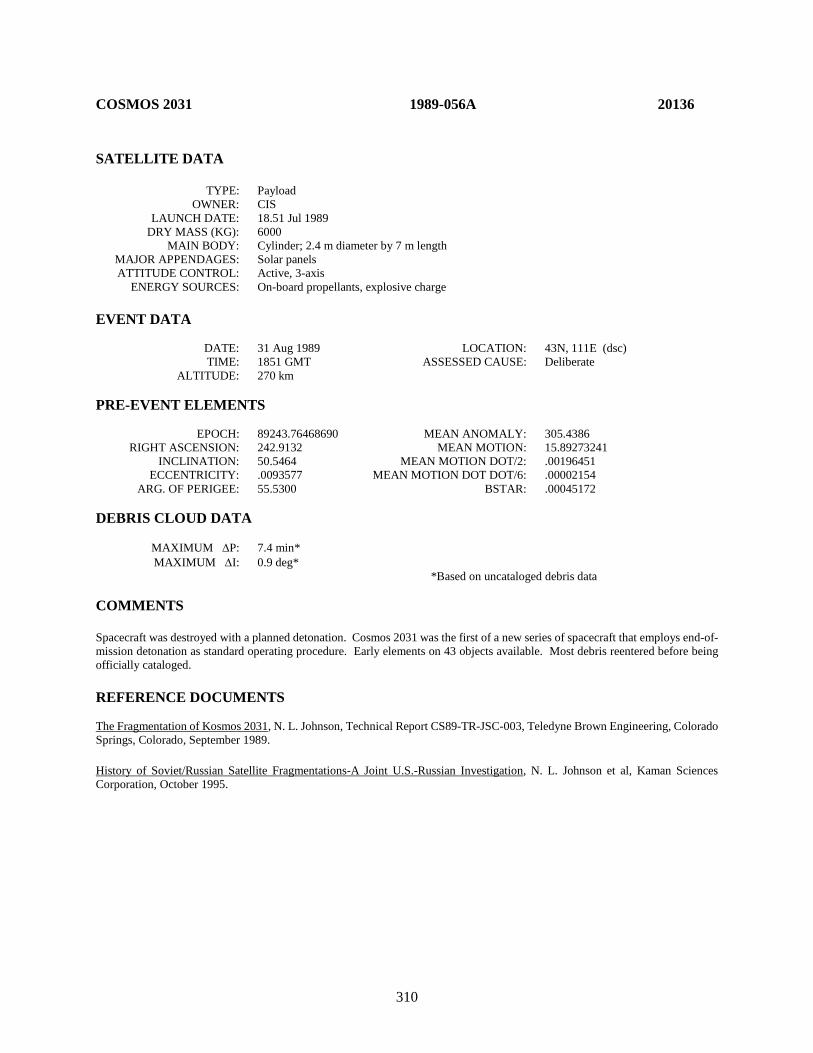
310
COSMOS 2031 1989-056A 20136 SATELLITE DATA TYPE: Payload OWNER: CIS LAUNCH DATE: 18.51 Jul 1989 DRY MASS (KG): 6000 MAIN BODY: Cylinder; 2.4 m diameter by 7 m length MAJOR APPENDAGES: Solar panels ATTITUDE CONTROL: Active, 3-axis ENERGY SOURCES: On-board propellants, explosive charge EVENT DATA DATE: 31 Aug 1989 LOCATION: 43N, 111E (dsc) TIME: 1851 GMT ASSESSED CAUSE: Deliberate ALTITUDE: 270 km PRE-EVENT ELEMENTS EPOCH: 89243.76468690 MEAN ANOMALY: 305.4386 RIGHT ASCENSION: 242.9132 MEAN MOTION: 15.89273241 INCLINATION: 50.5464 MEAN MOTION DOT/2: .00196451 ECCENTRICITY: .0093577 MEAN MOTION DOT DOT/6: .00002154 ARG. OF PERIGEE: 55.5300 BSTAR: .00045172 DEBRIS CLOUD DATA MAXIMUM ∆P: 7.4 min* MAXIMUM ∆I: 0.9 deg* *Based on uncataloged debris data COMMENTS Spacecraft was destroyed with a planned detonation. Cosmos 2031 was the first of a new series of spacecraft that employs end-of-mission detonation as standard operating procedure. Early elements on 43 objects available. Most debris reentered before being officially cataloged. REFERENCE DOCUMENTS The Fragmentation of Kosmos 2031, N. L. Johnson, Technical Report CS89-TR-JSC-003, Teledyne Brown Engineering, Colorado Springs, Colorado, September 1989. History of Soviet/Russian Satellite Fragmentations-A Joint U.S.-Russian Investigation, N. L. Johnson et al, Kaman Sciences Corporation, October 1995.
311
Cosmos 2031 debris cloud remnant of 43 objects 3 days after the event as reconstructed from Naval Space Surveillance System database. This diagram is taken
from the cited reference.
0
200
400
600
800
1000
1200
85 90 95 100
Apog
ee/P
erig
ee A
ltitu
de (k
m)
Period (min)
Apogee
Perigee
SSN 20136
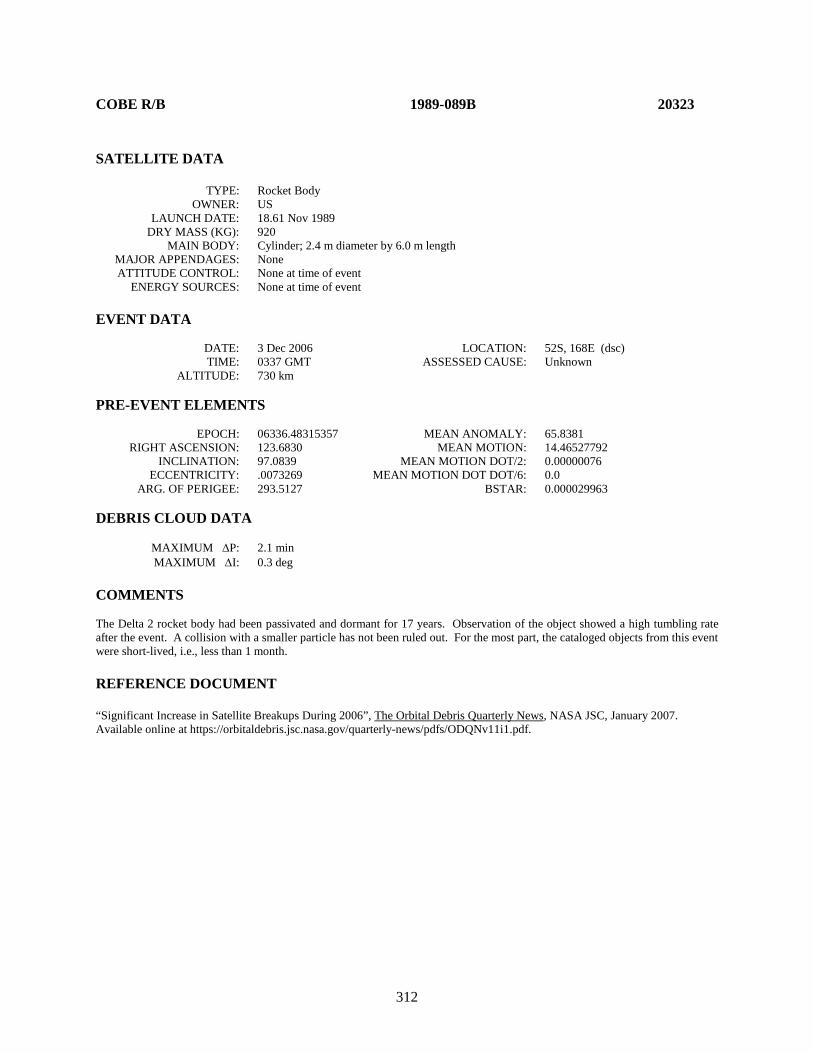
312
COBE R/B 1989-089B 20323 SATELLITE DATA TYPE: Rocket Body OWNER: US LAUNCH DATE: 18.61 Nov 1989 DRY MASS (KG): 920 MAIN BODY: Cylinder; 2.4 m diameter by 6.0 m length MAJOR APPENDAGES: None ATTITUDE CONTROL: None at time of event ENERGY SOURCES: None at time of event EVENT DATA DATE: 3 Dec 2006 LOCATION: 52S, 168E (dsc) TIME: 0337 GMT ASSESSED CAUSE: Unknown ALTITUDE: 730 km PRE-EVENT ELEMENTS EPOCH: 06336.48315357 MEAN ANOMALY: 65.8381 RIGHT ASCENSION: 123.6830 MEAN MOTION: 14.46527792 INCLINATION: 97.0839 MEAN MOTION DOT/2: 0.00000076 ECCENTRICITY: .0073269 MEAN MOTION DOT DOT/6: 0.0 ARG. OF PERIGEE: 293.5127 BSTAR: 0.000029963 DEBRIS CLOUD DATA MAXIMUM ∆P: 2.1 min MAXIMUM ∆I: 0.3 deg COMMENTS The Delta 2 rocket body had been passivated and dormant for 17 years. Observation of the object showed a high tumbling rate after the event. A collision with a smaller particle has not been ruled out. For the most part, the cataloged objects from this event were short-lived, i.e., less than 1 month. REFERENCE DOCUMENT “Significant Increase in Satellite Breakups During 2006”, The Orbital Debris Quarterly News, NASA JSC, January 2007. Available online at https://orbitaldebris.jsc.nasa.gov/quarterly-news/pdfs/ODQNv11i1.pdf.
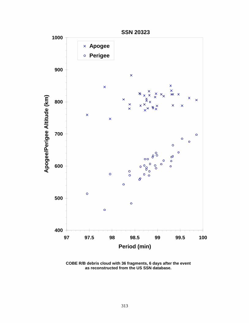
313
COBE R/B debris cloud with 36 fragments, 6 days after the event as reconstructed from the US SSN database.
400
500
600
700
800
900
1000
97 97.5 98 98.5 99 99.5 100
Period (min)
Apo
gee/
Perig
ee A
ltitu
de (k
m)
Apogee Perigee
SSN 20323
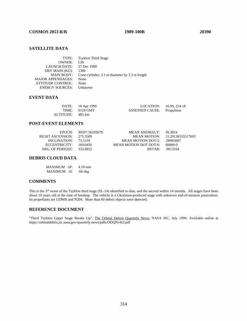
314
COSMOS 2053 R/B 1989-100B 20390 SATELLITE DATA TYPE: Tsyklon Third Stage OWNER: CIS LAUNCH DATE: 27 Dec 1989 DRY MASS (KG): 1360 MAIN BODY: Cone-cylinder; 2.1 m diameter by 3.3 m length MAJOR APPENDAGES: None ATTITUDE CONTROL: None ENERGY SOURCES: Unknown EVENT DATA DATE: 18 Apr 1999 LOCATION: 16.9S, 234.1E TIME: 0119 GMT ASSESSED CAUSE: Propulsion ALTITUDE: 485 km POST-EVENT ELEMENTS EPOCH: 99107.56102679 MEAN ANOMALY: 26.3814 RIGHT ASCENSION: 275.5509 MEAN MOTION: 15.29126555517603 INCLINATION: 73.5159 MEAN MOTION DOT/2: .00003667 ECCENTRICITY: .0010450 MEAN MOTION DOT DOT/6: 00000-0 ARG. OF PERIGEE: 333.6852 BSTAR: .0013164 DEBRIS CLOUD DATA MAXIMUM ∆P: 4.18 min MAXIMUM ∆I: .66 deg COMMENTS This is the 3rd event of the Tsyklon third stage (SL-14) identified to date, and the second within 14 months. All stages have been about 10 years old at the time of breakup. The vehicle is a Ukrainian-produced stage with unknown end-of-mission passivation. Its propellants are UDMH and N204. More than 60 debris objects were detected. REFERENCE DOCUMENT “Third Tsyklon Upper Stage Breaks Up”, The Orbital Debris Quarterly News, NASA JSC, July 1999. Available online at https://orbitaldebris.jsc.nasa.gov/quarterly-news/pdfs/ODQNv4i3.pdf
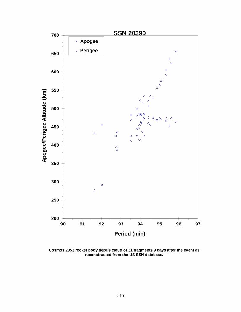
315
Cosmos 2053 rocket body debris cloud of 31 fragments 9 days after the event as reconstructed from the US SSN database.
200
250
300
350
400
450
500
550
600
650
700
90 91 92 93 94 95 96 97
Apog
ee/P
erig
ee A
ltitu
de (k
m)
Period (min)
Apogee
Perigee
SSN 20390

316
COSMOS 2054 ULLAGE MOTOR 1989-101E 20399 SATELLITE DATA TYPE: Mission Related Debris OWNER: CIS LAUNCH DATE: 27.47 Dec 1989 DRY MASS (KG): 55 MAIN BODY: Ellipsoid; 0.6 m diameter by 1 m length MAJOR APPENDAGES: None ATTITUDE CONTROL: None ENERGY SOURCES: On-board propellants EVENT DATA DATE: Jul 1992 (?) LOCATION: Unknown TIME: Unknown ASSESSED CAUSE: Propulsion ALTITUDE: Unknown PRE-EVENT ELEMENTS EPOCH: 92182.661921495 MEAN ANOMALY: 6.2737 RIGHT ASCENSION: 305.7529 MEAN MOTION: 2.98492104 INCLINATION: 47.1115 MEAN MOTION DOT/2: .00001757 ECCENTRICITY: .6700939 MEAN MOTION DOT DOT/6: .0 ARG. OF PERIGEE: 319.3202 BSTAR: .0014976 DEBRIS CLOUD DATA MAXIMUM ∆P: Unknown MAXIMUM ∆I: Unknown COMMENTS Parent satellite was one of two small engine units that are routinely released after the first burn of the Proton fourth stage. The nature of these objects was identified by Dr. Boris V. Chernlatiev, Deputy Constructor for the Energiya NPO, in October 1992. The cause of this fragmentation is assumed to be related to the residual hypergolic propellants on board and failure of the membrane separating the fuel and oxidizer. NAVSPASUR observed 18 objects that were associated with this breakup. Twelve element sets were generated, but were of insufficient quality for a credible Gabbard Diagram or BLAST point. One object was cataloged on this event in early August 1992. This was the fifth in a series of fragmentations of this object type, and was the first located in a geosynchronous transfer orbit. REFERENCE DOCUMENTS The Fragmentation of Proton Debris, D. J. Nauer, TBE Technical Report CS93-LKD-004, Teledyne Brown Engineering, Colorado Springs, 31 December 1992. Analysis of Fragmentations From December 1992 - February 1993, TBE Technical Report CS93-LKD-010, Teledyne Brown Engineering, Colorado Springs, 30 March 1993. History of Soviet/Russian Satellite Fragmentations-A Joint U.S.-Russian Investigation, N. L. Johnson et al, Kaman Sciences Corporation, October 1995. “Identification and Resolution of an Orbital Debris Problem with the Proton Launch Vehicle”, B. V. Cherniatiev et al, Proceedings of the First European Conference on Space Debris, April 1993.

317
Insufficient data to construct a Gabbard diagram.

318
COSMOS 2079-81 ULLAGE MOTOR 1990-045F 20630 SATELLITE DATA TYPE: Mission Related Debris OWNER: CIS LAUNCH DATE: 20.0 May 1990 DRY MASS (KG): 56 MAIN BODY: ellipsoid; 0.6 m diameter x 1 m length MAJOR APPENDAGES: none ATTITUDE CONTROL: none ENERGY SOURCES: on-board propellants EVENT DATA DATE: 18 Nov 2011 LOCATION: 60.2S, 217.8E (asc) TIME: 0344 GMT ASSESSED CAUSE: Propulsion ALTITUDE: 1292.55 km PRE-EVENT ELEMENTS EPOCH: 11321.47402816 MEAN ANOMALY: 6.2919 RIGHT ASCENSION: 24.8398 MEAN MOTION: 4.33127778 INCLINATION: 65.0258 MEAN MOTION DOT/2: 0.00000578 ECCENTRICITY: 0.5722498 MEAN MOTION DOT DOT/6: 0.0 ARG. OF PERIGEE: 332.9281 BSTAR: 0.00072502 DEBRIS CLOUD DATA MAXIMUM ∆P: 0 min MAXIMUM ∆I: 0 deg COMMENTS This is the 39th known breakup of a Proton-DM SOZ ullage unit since 1984. The breakups are believed to be caused by residual propellants. Russian officials have been aware of the problem since 1992 and have made design changes, although the date of full implementation is unknown. Only one object has been officially cataloged. Due to the difficulty in observing and cataloging debris in deep-space, highly elliptical orbits, a much larger debris ensemble may have been created by this event. REFERENCE DOCUMENT History of Soviet/Russian Satellite Fragmentations: A Joint U.S.-Russian Investigation. N.L. Johnson et al. Kaman Sciences Corporation, October 2005. “Only a Few Minor Satellite Breakups in 2011”, The Orbital Debris Quarterly News, NASA JSC, January 2012. Available online at https://orbitaldebris.jsc.nasa.gov/quarterly-news/ODQNv16i1.pdf.
319
Insufficient data to construct a Gabbard diagram.

320
COSMOS 2079-2081 ULLAGE MOTOR 1990-045G 20631 SATELLITE DATA TYPE: Mission Related Debris OWNER: CIS LAUNCH DATE: 19 May 1990 DRY MASS (KG): 55 MAIN BODY: Ellipsoid; 0.6 m diameter by 1 m length MAJOR APPENDAGES: None ATTITUDE CONTROL: None ENERGY SOURCES: On-board propellants EVENT DATA DATE: ~28 Mar 1999 LOCATION: Unknown TIME: Unknown ASSESSED CAUSE: Propulsion ALTITUDE: Unknown POST-EVENT ELEMENTS EPOCH: 99087.88291821 MEAN ANOMALY: 123.5812 RIGHT ASCENSION: 319.9610 MEAN MOTION: 4.24414150137202 INCLINATION: 64.8090 MEAN MOTION DOT/2: 0.00000311 ECCENTRICITY: 0.5789417 MEAN MOTION DOT DOT/6: 0.0 ARG. OF PERIGEE: 199.4305 BSTAR: 0.0040281 DEBRIS CLOUD DATA MAXIMUM ∆P: Unknown MAXIMUM ∆I: Unknown COMMENTS This is the 20th event of the Proton Block DM SOZ Ullage Motor class identified to date; it is the ninth associated with a GLONASS mission. This mission was conducted before the engineering defect was identified and passivation measures implemented. In this orbit, debris may be long-lived but hard to track. 76 debris objects were detected. REFERENCE DOCUMENT “Abandoned Proton Ullage Motors Continue to Create Debris”, The Orbital Debris Quarterly News, NASA JSC, April 1999. Available online at https://orbitaldebris.jsc.nasa.gov/quarterly-news/pdfs/ODQNv4i2.pdf.

321
Insufficient data to construct a Gabbard diagram.
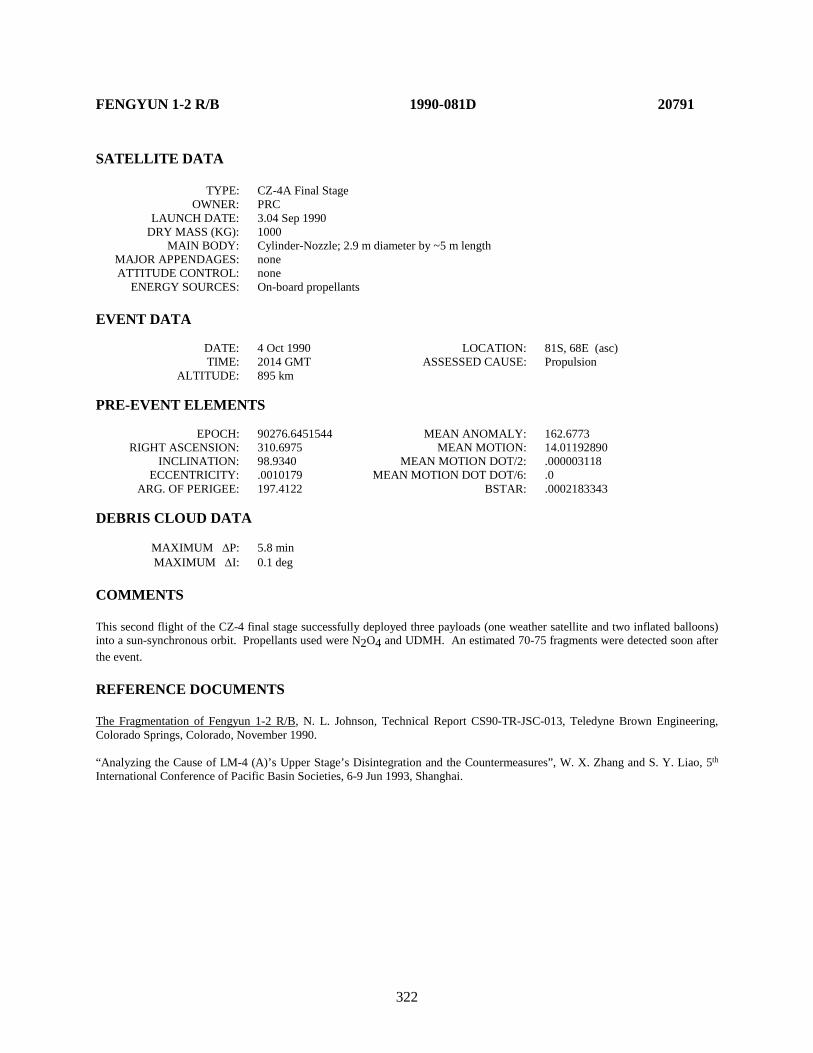
322
FENGYUN 1-2 R/B 1990-081D 20791 SATELLITE DATA TYPE: CZ-4A Final Stage OWNER: PRC LAUNCH DATE: 3.04 Sep 1990 DRY MASS (KG): 1000 MAIN BODY: Cylinder-Nozzle; 2.9 m diameter by ~5 m length MAJOR APPENDAGES: none ATTITUDE CONTROL: none ENERGY SOURCES: On-board propellants EVENT DATA DATE: 4 Oct 1990 LOCATION: 81S, 68E (asc) TIME: 2014 GMT ASSESSED CAUSE: Propulsion ALTITUDE: 895 km PRE-EVENT ELEMENTS EPOCH: 90276.6451544 MEAN ANOMALY: 162.6773 RIGHT ASCENSION: 310.6975 MEAN MOTION: 14.01192890 INCLINATION: 98.9340 MEAN MOTION DOT/2: .000003118 ECCENTRICITY: .0010179 MEAN MOTION DOT DOT/6: .0 ARG. OF PERIGEE: 197.4122 BSTAR: .0002183343 DEBRIS CLOUD DATA MAXIMUM ∆P: 5.8 min MAXIMUM ∆I: 0.1 deg COMMENTS This second flight of the CZ-4 final stage successfully deployed three payloads (one weather satellite and two inflated balloons) into a sun-synchronous orbit. Propellants used were N2O4 and UDMH. An estimated 70-75 fragments were detected soon after the event. REFERENCE DOCUMENTS The Fragmentation of Fengyun 1-2 R/B, N. L. Johnson, Technical Report CS90-TR-JSC-013, Teledyne Brown Engineering, Colorado Springs, Colorado, November 1990. “Analyzing the Cause of LM-4 (A)’s Upper Stage’s Disintegration and the Countermeasures”, W. X. Zhang and S. Y. Liao, 5th International Conference of Pacific Basin Societies, 6-9 Jun 1993, Shanghai.
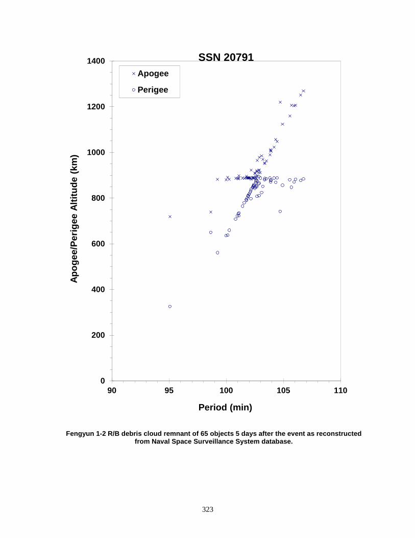
323
Fengyun 1-2 R/B debris cloud remnant of 65 objects 5 days after the event as reconstructed from Naval Space Surveillance System database.
0
200
400
600
800
1000
1200
1400
90 95 100 105 110
Apog
ee/P
erig
ee A
ltitu
de (k
m)
Period (min)
Apogee
Perigee
SSN 20791

324
COSMOS 2101 1990-087A 20828 SATELLITE DATA TYPE: Payload OWNER: CIS LAUNCH DATE: 1.46 Oct 1990 DRY MASS (KG): 6000 MAIN BODY: Cylinder; 2.4 m diameter by 7 m length MAJOR APPENDAGES: Solar panels ATTITUDE CONTROL: Active, 3-axis ENERGY SOURCES: On-board propellants, explosive charge EVENT DATA DATE: 30 Nov 1990 LOCATION: 54N, 157E (dsc) TIME: 1720 GMT ASSESSED CAUSE: Deliberate ALTITUDE: 210 km PRE-EVENT ELEMENTS EPOCH: 90334.45391019 MEAN ANOMALY: 205.3252 RIGHT ASCENSION: 347.9431 MEAN MOTION: 16.12811753 INCLINATION: 64.7547 MEAN MOTION DOT/2: .00671617 ECCENTRICITY: .0065418 MEAN MOTION DOT DOT/6: .000035339 ARG. OF PERIGEE: 155.2258 BSTAR: .00040815 DEBRIS CLOUD DATA MAXIMUM ∆P: >7.3 min* MAXIMUM ∆I: 0.3 deg* *Based on uncataloged debris data COMMENTS Spacecraft was destroyed with a planned detonation. Second fragmentation of the Cosmos 2031 subclass. Early elements on only 7 objects available. Most debris reentered before being officially cataloged. REFERENCE DOCUMENTS The Fragmentation of Kosmos 2101, N. L. Johnson, Technical Report CS91-TR-JSC-002, Teledyne Brown Engineering, Colorado Springs, Colorado, January 1991. History of Soviet/Russian Satellite Fragmentations-A Joint U.S.-Russian Investigation, N. L. Johnson et al, Kaman Sciences Corporation, October 1995.

325
Cosmos 2101 debris cloud remnant of 7 objects 3 days after the event was reconstructed from Naval Space Surveillance System database. This diagram is taken
from the cited reference.
0
200
400
600
800
1000
1200
89 91 93 95 97 99
Apog
ee/P
erig
ee A
ltitu
de (k
m)
Period (min)
Apogee
Perigee
SSN 20828
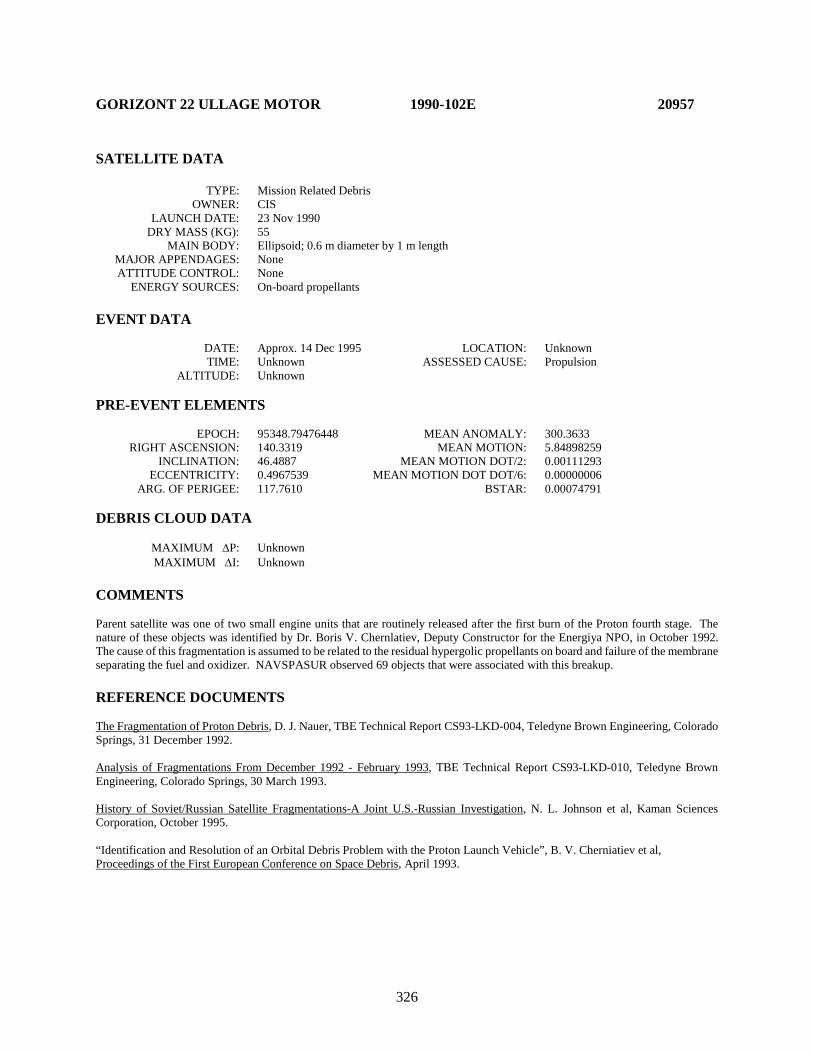
326
GORIZONT 22 ULLAGE MOTOR 1990-102E 20957 SATELLITE DATA TYPE: Mission Related Debris OWNER: CIS LAUNCH DATE: 23 Nov 1990 DRY MASS (KG): 55 MAIN BODY: Ellipsoid; 0.6 m diameter by 1 m length MAJOR APPENDAGES: None ATTITUDE CONTROL: None ENERGY SOURCES: On-board propellants EVENT DATA DATE: Approx. 14 Dec 1995 LOCATION: Unknown TIME: Unknown ASSESSED CAUSE: Propulsion ALTITUDE: Unknown PRE-EVENT ELEMENTS EPOCH: 95348.79476448 MEAN ANOMALY: 300.3633 RIGHT ASCENSION: 140.3319 MEAN MOTION: 5.84898259 INCLINATION: 46.4887 MEAN MOTION DOT/2: 0.00111293 ECCENTRICITY: 0.4967539 MEAN MOTION DOT DOT/6: 0.00000006 ARG. OF PERIGEE: 117.7610 BSTAR: 0.00074791 DEBRIS CLOUD DATA MAXIMUM ∆P: Unknown MAXIMUM ∆I: Unknown COMMENTS Parent satellite was one of two small engine units that are routinely released after the first burn of the Proton fourth stage. The nature of these objects was identified by Dr. Boris V. Chernlatiev, Deputy Constructor for the Energiya NPO, in October 1992. The cause of this fragmentation is assumed to be related to the residual hypergolic propellants on board and failure of the membrane separating the fuel and oxidizer. NAVSPASUR observed 69 objects that were associated with this breakup. REFERENCE DOCUMENTS The Fragmentation of Proton Debris, D. J. Nauer, TBE Technical Report CS93-LKD-004, Teledyne Brown Engineering, Colorado Springs, 31 December 1992. Analysis of Fragmentations From December 1992 - February 1993, TBE Technical Report CS93-LKD-010, Teledyne Brown Engineering, Colorado Springs, 30 March 1993. History of Soviet/Russian Satellite Fragmentations-A Joint U.S.-Russian Investigation, N. L. Johnson et al, Kaman Sciences Corporation, October 1995. “Identification and Resolution of an Orbital Debris Problem with the Proton Launch Vehicle”, B. V. Cherniatiev et al, Proceedings of the First European Conference on Space Debris, April 1993.

327
Insufficient data to construct a Gabbard diagram.
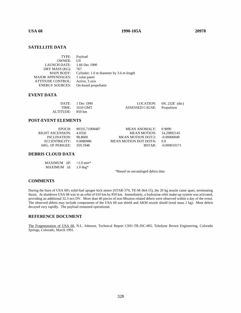
328
USA 68 1990-105A 20978 SATELLITE DATA TYPE: Payload OWNER: US LAUNCH DATE: 1.66 Dec 1990 DRY MASS (KG): 767 MAIN BODY: Cylinder; 1.0 m diameter by 3.6 m length MAJOR APPENDAGES: 1 solar panel ATTITUDE CONTROL: Active, 3 axis ENERGY SOURCES: On-board propellants EVENT DATA DATE: 1 Dec 1990 LOCATION: 6N, 232E (dsc) TIME: 1610 GMT ASSESSED CAUSE: Propulsion ALTITUDE: 850 km POST-EVENT ELEMENTS EPOCH: 90335.71008487 MEAN ANOMALY: 0.9090 RIGHT ASCENSION: 4.0350 MEAN MOTION: 14.29892145 INCLINATION: 98.8600 MEAN MOTION DOT/2: -0.00000049 ECCENTRICITY: 0.0080986 MEAN MOTION DOT DOT/6: 0.0 ARG. OF PERIGEE: 359.1948 BSTAR: -0.000010171 DEBRIS CLOUD DATA MAXIMUM ∆P: >2.0 min* MAXIMUM ∆I: 1.0 deg* *Based on uncataloged debris data COMMENTS During the burn of USA 68's solid-fuel apogee kick motor (STAR-37S, TE-M-364-15), the 20 kg nozzle came apart, terminating thrust. At shutdown USA 68 was in an orbit of 610 km by 850 km. Immediately, a hydrazine orbit make-up system was activated, providing an additional 32.3 m/s DV. More than 40 pieces of non-Mission related debris were observed within a day of the event. The observed debris may include components of the USA 68 sun shield and AKM nozzle shield (total mass 2 kg). Most debris decayed very rapidly. The payload remained operational. REFERENCE DOCUMENT The Fragmentation of USA 68, N.L. Johnson, Technical Report CS91-TR-JSC-005, Teledyne Brown Engineering, Colorado Springs, Colorado, March 1991.
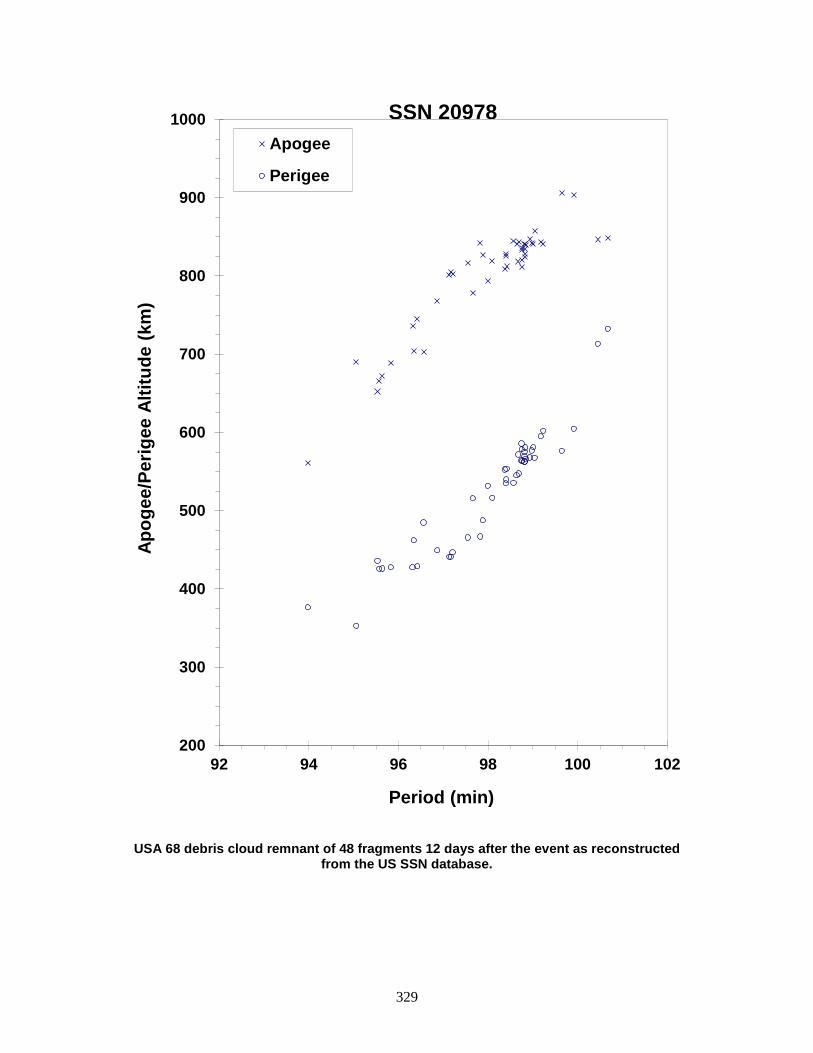
329
USA 68 debris cloud remnant of 48 fragments 12 days after the event as reconstructed from the US SSN database.
200
300
400
500
600
700
800
900
1000
92 94 96 98 100 102
Apog
ee/P
erig
ee A
ltitu
de (k
m)
Period (min)
Apogee
Perigee
SSN 20978
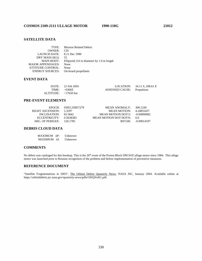
330
COSMOS 2109-2111 ULLAGE MOTOR 1990-110G 21012 SATELLITE DATA TYPE: Mission Related Debris OWNER: CIS LAUNCH DATE: 8.11 Dec 1990 DRY MASS (KG): 55 MAIN BODY: Ellipsoid; 0.6 m diameter by 1.0 m length MAJOR APPENDAGES: None ATTITUDE CONTROL: None ENERGY SOURCES: On-board propellants EVENT DATA DATE: 21 Feb 2003 LOCATION: 34.11 S, 208.61 E TIME: ~0300Z ASSESSED CAUSE: Propulsion ALTITUDE: ~17650 km PRE-EVENT ELEMENTS EPOCH: 03051.93857279 MEAN ANOMALY: 300.1330 RIGHT ASCENSION: 5.3297 MEAN MOTION: 4.24855437 INCLINATION: 65.3642 MEAN MOTION DOT/2: -0.00000082 ECCENTRICITY: 0.5638383 MEAN MOTION DOT DOT/6: 0.0 ARG. OF PERIGEE: 126.1785 BSTAR: -0.00014197 DEBRIS CLOUD DATA MAXIMUM ∆P: Unknown MAXIMUM ∆I: Unknown COMMENTS No debris was cataloged for this breakup. This is the 26th event of the Proton Block DM SOZ ullage motor since 1984. This ullage motor was launched prior to Russian recognition of the problem and before implementation of preventive measures. REFERENCE DOCUMENT “Satellite Fragmentations in 2003”, The Orbital Debris Quarterly News, NASA JSC, January 2004. Available online at https://orbitaldebris.jsc.nasa.gov/quarterly-news/pdfs/ODQNv8i1.pdf.

331
Insufficient data to construct a Gabbard diagram.
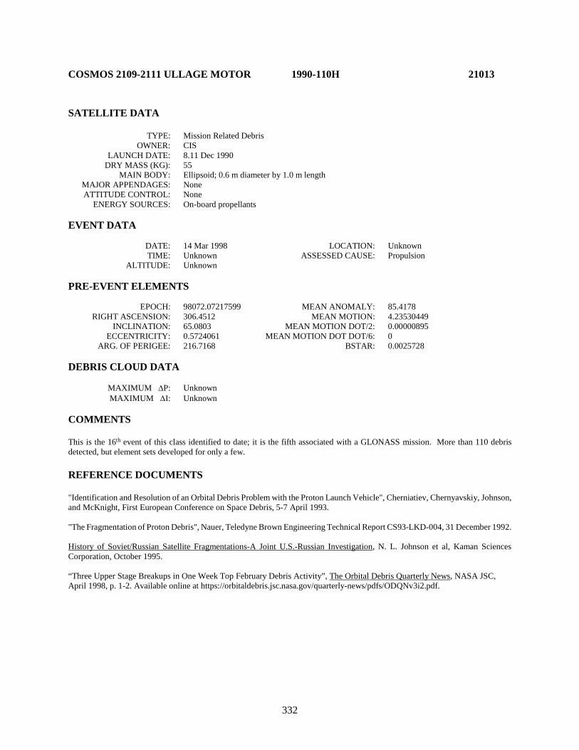
332
COSMOS 2109-2111 ULLAGE MOTOR 1990-110H 21013 SATELLITE DATA TYPE: Mission Related Debris OWNER: CIS LAUNCH DATE: 8.11 Dec 1990 DRY MASS (KG): 55 MAIN BODY: Ellipsoid; 0.6 m diameter by 1.0 m length MAJOR APPENDAGES: None ATTITUDE CONTROL: None ENERGY SOURCES: On-board propellants EVENT DATA DATE: 14 Mar 1998 LOCATION: Unknown TIME: Unknown ASSESSED CAUSE: Propulsion ALTITUDE: Unknown PRE-EVENT ELEMENTS EPOCH: 98072.07217599 MEAN ANOMALY: 85.4178 RIGHT ASCENSION: 306.4512 MEAN MOTION: 4.23530449 INCLINATION: 65.0803 MEAN MOTION DOT/2: 0.00000895 ECCENTRICITY: 0.5724061 MEAN MOTION DOT DOT/6: 0 ARG. OF PERIGEE: 216.7168 BSTAR: 0.0025728 DEBRIS CLOUD DATA MAXIMUM ∆P: Unknown MAXIMUM ∆I: Unknown COMMENTS This is the 16th event of this class identified to date; it is the fifth associated with a GLONASS mission. More than 110 debris detected, but element sets developed for only a few. REFERENCE DOCUMENTS "Identification and Resolution of an Orbital Debris Problem with the Proton Launch Vehicle", Cherniatiev, Chernyavskiy, Johnson, and McKnight, First European Conference on Space Debris, 5-7 April 1993. "The Fragmentation of Proton Debris", Nauer, Teledyne Brown Engineering Technical Report CS93-LKD-004, 31 December 1992. History of Soviet/Russian Satellite Fragmentations-A Joint U.S.-Russian Investigation, N. L. Johnson et al, Kaman Sciences Corporation, October 1995. “Three Upper Stage Breakups in One Week Top February Debris Activity”, The Orbital Debris Quarterly News, NASA JSC, April 1998, p. 1-2. Available online at https://orbitaldebris.jsc.nasa.gov/quarterly-news/pdfs/ODQNv3i2.pdf.

333
Insufficient data to construct a Gabbard diagram.

334
ITALSAT 1/EUTELSAT 2 F2 R/B 1991-003C 21057 SATELLITE DATA TYPE: Ariane 4 H-10 Third Stage OWNER: France LAUNCH DATE: 15.97 Jan 1991 DRY MASS (KG): 1760 MAIN BODY: Cylinder; 2.6 m diameter by 11.4 m length MAJOR APPENDAGES: None ATTITUDE CONTROL: None at time of the event. ENERGY SOURCES: On-board propellants EVENT DATA DATE: Late Apr-early May 1996 LOCATION: Unknown TIME: Unknown ASSESSED CAUSE: Propulsion ALTITUDE: Unknown PRE-EVENT ELEMENTS EPOCH: 96106.15481796 MEAN ANOMALY: 312.6005 RIGHT ASCENSION: 104.8696 MEAN MOTION: 2.66496263 INCLINATION: 6.7146 MEAN MOTION DOT/2: 0.00007071 ECCENTRICITY: 0.6989841 MEAN MOTION DOT DOT/6: 0 ARG. OF PERIGEE: 132.7372 BSTAR: 0.0012265 DEBRIS CLOUD DATA MAXIMUM ∆P: 147.3 min MAXIMUM ∆I: 1.3 deg COMMENTS The event was first recognized by Naval Space Command analysts in early May 1996. Element sets for as many as 20 debris were developed. Since deliberate passivation of Ariane GTO stages was not implemented until 1993, the vehicle was not purged of its residual propellants or pressurants. REFERENCE DOCUMENT “Newly Recognized 1996 Breakup”, N. L. Johnson, The Orbital Debris Quarterly News, April 1997, p. 2. Available online at https://orbitaldebris.jsc.nasa.gov/quarterly-news/pdfs/ODQNv2i2.pdf.

335
Italsat 1/Eutelsat 2 F2 R/B debris cloud of 20 fragments 1 year after the event as reconstructed from the US SSN database.
0
5000
10000
15000
20000
25000
30000
35000
40000
45000
375 475 575
Apog
ee/P
erig
ee A
ltitu
de (k
m)
Period (min)
Apogee
Perigee
SSN 21057
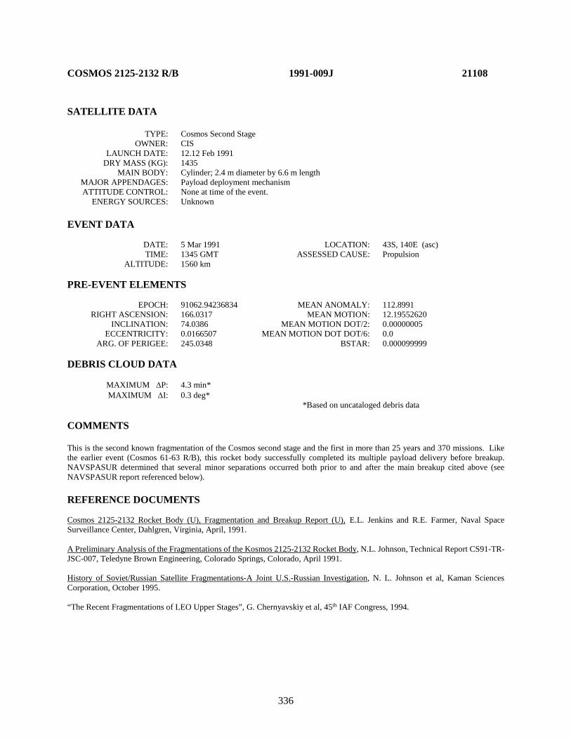
336
COSMOS 2125-2132 R/B 1991-009J 21108 SATELLITE DATA TYPE: Cosmos Second Stage OWNER: CIS LAUNCH DATE: 12.12 Feb 1991 DRY MASS (KG): 1435 MAIN BODY: Cylinder; 2.4 m diameter by 6.6 m length MAJOR APPENDAGES: Payload deployment mechanism ATTITUDE CONTROL: None at time of the event. ENERGY SOURCES: Unknown EVENT DATA DATE: 5 Mar 1991 LOCATION: 43S, 140E (asc) TIME: 1345 GMT ASSESSED CAUSE: Propulsion ALTITUDE: 1560 km PRE-EVENT ELEMENTS EPOCH: 91062.94236834 MEAN ANOMALY: 112.8991 RIGHT ASCENSION: 166.0317 MEAN MOTION: 12.19552620 INCLINATION: 74.0386 MEAN MOTION DOT/2: 0.00000005 ECCENTRICITY: 0.0166507 MEAN MOTION DOT DOT/6: 0.0 ARG. OF PERIGEE: 245.0348 BSTAR: 0.000099999 DEBRIS CLOUD DATA MAXIMUM ∆P: 4.3 min* MAXIMUM ∆I: 0.3 deg* *Based on uncataloged debris data COMMENTS This is the second known fragmentation of the Cosmos second stage and the first in more than 25 years and 370 missions. Like the earlier event (Cosmos 61-63 R/B), this rocket body successfully completed its multiple payload delivery before breakup. NAVSPASUR determined that several minor separations occurred both prior to and after the main breakup cited above (see NAVSPASUR report referenced below). REFERENCE DOCUMENTS Cosmos 2125-2132 Rocket Body (U), Fragmentation and Breakup Report (U), E.L. Jenkins and R.E. Farmer, Naval Space Surveillance Center, Dahlgren, Virginia, April, 1991. A Preliminary Analysis of the Fragmentations of the Kosmos 2125-2132 Rocket Body, N.L. Johnson, Technical Report CS91-TR-JSC-007, Teledyne Brown Engineering, Colorado Springs, Colorado, April 1991. History of Soviet/Russian Satellite Fragmentations-A Joint U.S.-Russian Investigation, N. L. Johnson et al, Kaman Sciences Corporation, October 1995. “The Recent Fragmentations of LEO Upper Stages”, G. Chernyavskiy et al, 45th IAF Congress, 1994.

337
Cosmos 2125-32 R/B debris cloud of 54 objects 5 days after the major breakup event as reconstructed from Naval Space Surveillance System database. This diagram is taken from
the reference cited at the top of this page.
1000
1200
1400
1600
1800
2000
116 117 118 119 120 121
Apog
ee/P
erig
ee A
ltitu
de (k
m)
Period (min)
Apogee
Perigee
SSN 21108

338
COSMOS 2133 ULLAGE MOTOR 1991-010D 21114 SATELLITE DATA TYPE: Mission Related Debris OWNER: CIS LAUNCH DATE: 12 Feb 1991 DRY MASS (KG): 55 MAIN BODY: Ellipsoid; 0.6 m diameter by 1 m length MAJOR APPENDAGES: None ATTITUDE CONTROL: Unknown ENERGY SOURCES: On-board propellants EVENT DATA DATE: 7 May 1994 LOCATION: 10N, 112E TIME: 0930 GMT ASSESSED CAUSE: Propulsion ALTITUDE: 16195 km PRE-EVENT ELEMENTS EPOCH: 94126.31580012 MEAN ANOMALY: 240.6661 RIGHT ASCENSION: 110.6447 MEAN MOTION: 3.78477656 INCLINATION: 46.6223 MEAN MOTION DOT/2: 0.000127656 ECCENTRICITY: 0.6204369 MEAN MOTION DOT DOT/6: 0.0 ARG. OF PERIGEE: 160.8637 BSTAR: 0.00086951 DEBRIS CLOUD DATA MAXIMUM ∆P: Unknown MAXIMUM ∆I: Unknown COMMENTS Parent satellite was one of two small engine units that are routinely released after the first burn of the Proton fourth stage. The nature of these objects was identified by Dr. Boris V. Chernlatiev, Deputy Constructor for the Energiya NPO, in October 1992. The cause of this fragmentation appears to be related to the residual hypergolic propellants on board and failure of the membrane separating the fuel and oxidizer. NAVSPASUR observed 38 objects that were associated with this breakup. Only 6 element sets were generated. This was the ninth in a series of fragmentations of this object type, and was the fourth located in a geosynchronous transfer orbit. Two possible fragmentation locations were calculated by the NAVSPOC. The numbers above represent the first possible calculated location. REFERENCE DOCUMENTS The Fragmentation of Proton Debris, D. J. Nauer, TBE Technical Report CS93-LKD-004, Teledyne Brown Engineering, Colorado Springs, 31 December 1992. Analysis of Fragmentations From December 1992 - February 1993, TBE Technical Report CS93-LKD-010, Teledyne Brown Engineering, Colorado Springs, 30 March 1993. The Fragmentation of Cosmos 2133 Debris, I. W. Grissom and D. J. Nauer, TBE Technical Report CS94-LKD-016, Teledyne Brown Engineering, Colorado Springs, 30 June 1994.

339
History of Soviet/Russian Satellite Fragmentations-A Joint U.S.-Russian Investigation, N. L. Johnson et al, Kaman Sciences Corporation, October 1995. “Identification and Resolution of an Orbital Debris Problem with the Proton Launch Vehicle”, B. V. Cherniatiev et al, Proceedings of the First European Conference on Space Debris, April 1993.
Gabbard diagram of six objects from the Cosmos 2133 debris fragmentation.
0
5000
10000
15000
20000
25000
335 345 355 365 375 385
Apog
ee/P
erig
ee A
ltitu
de (k
m)
Period (min)
Apogee
Perigee
SSN 21114
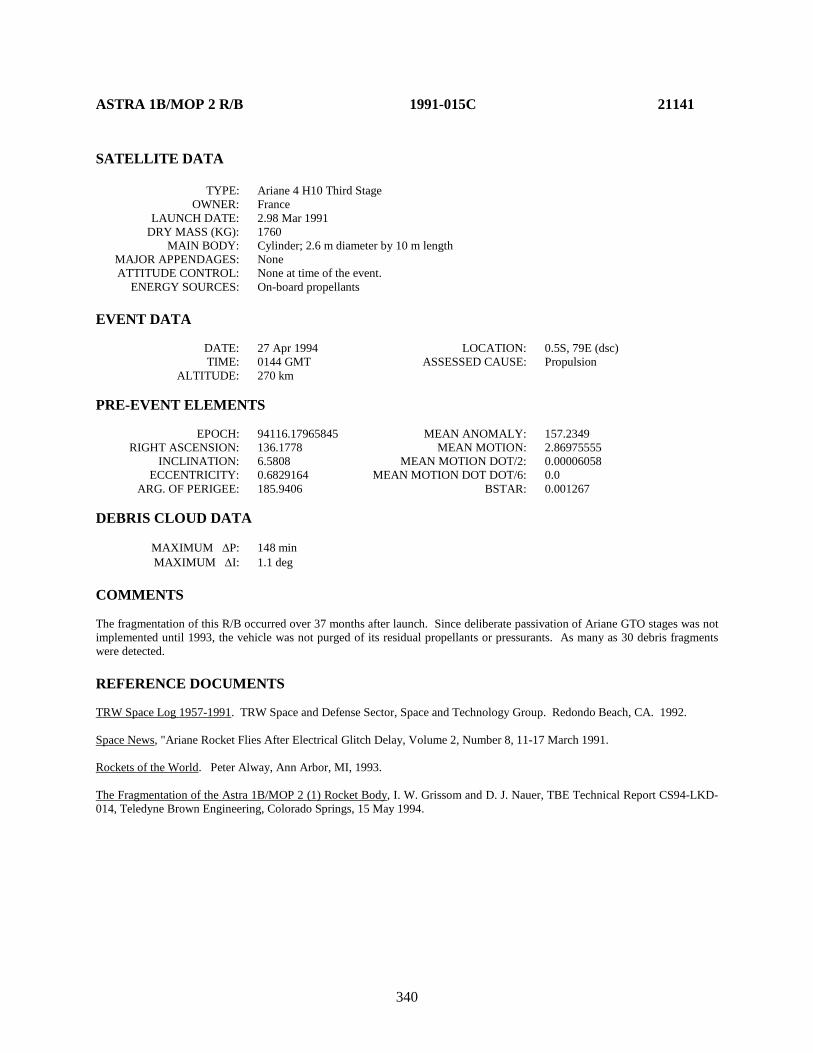
340
ASTRA 1B/MOP 2 R/B 1991-015C 21141 SATELLITE DATA TYPE: Ariane 4 H10 Third Stage OWNER: France LAUNCH DATE: 2.98 Mar 1991 DRY MASS (KG): 1760 MAIN BODY: Cylinder; 2.6 m diameter by 10 m length MAJOR APPENDAGES: None ATTITUDE CONTROL: None at time of the event. ENERGY SOURCES: On-board propellants EVENT DATA DATE: 27 Apr 1994 LOCATION: 0.5S, 79E (dsc) TIME: 0144 GMT ASSESSED CAUSE: Propulsion ALTITUDE: 270 km PRE-EVENT ELEMENTS EPOCH: 94116.17965845 MEAN ANOMALY: 157.2349 RIGHT ASCENSION: 136.1778 MEAN MOTION: 2.86975555 INCLINATION: 6.5808 MEAN MOTION DOT/2: 0.00006058 ECCENTRICITY: 0.6829164 MEAN MOTION DOT DOT/6: 0.0 ARG. OF PERIGEE: 185.9406 BSTAR: 0.001267 DEBRIS CLOUD DATA MAXIMUM ∆P: 148 min MAXIMUM ∆I: 1.1 deg COMMENTS The fragmentation of this R/B occurred over 37 months after launch. Since deliberate passivation of Ariane GTO stages was not implemented until 1993, the vehicle was not purged of its residual propellants or pressurants. As many as 30 debris fragments were detected. REFERENCE DOCUMENTS TRW Space Log 1957-1991. TRW Space and Defense Sector, Space and Technology Group. Redondo Beach, CA. 1992. Space News, "Ariane Rocket Flies After Electrical Glitch Delay, Volume 2, Number 8, 11-17 March 1991. Rockets of the World. Peter Alway, Ann Arbor, MI, 1993. The Fragmentation of the Astra 1B/MOP 2 (1) Rocket Body, I. W. Grissom and D. J. Nauer, TBE Technical Report CS94-LKD-014, Teledyne Brown Engineering, Colorado Springs, 15 May 1994.
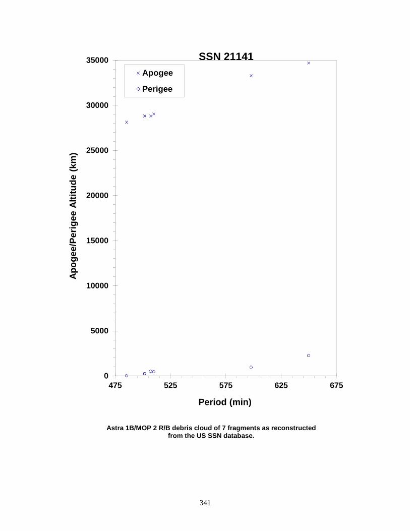
341
Astra 1B/MOP 2 R/B debris cloud of 7 fragments as reconstructed from the US SSN database.
0
5000
10000
15000
20000
25000
30000
35000
475 525 575 625 675
Apog
ee/P
erig
ee A
ltitu
de (k
m)
Period (min)
Apogee
Perigee
SSN 21141
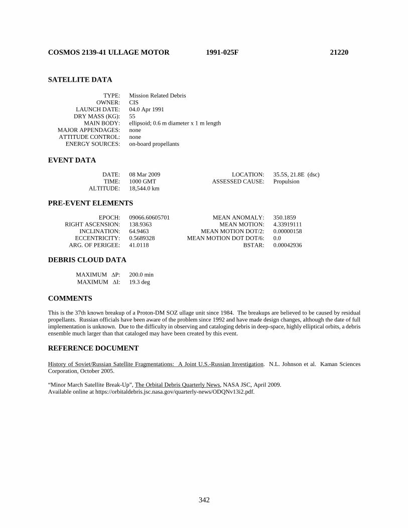
342
COSMOS 2139-41 ULLAGE MOTOR 1991-025F 21220 SATELLITE DATA TYPE: Mission Related Debris OWNER: CIS LAUNCH DATE: 04.0 Apr 1991 DRY MASS (KG): 55 MAIN BODY: ellipsoid; 0.6 m diameter x 1 m length MAJOR APPENDAGES: none ATTITUDE CONTROL: none ENERGY SOURCES: on-board propellants EVENT DATA DATE: 08 Mar 2009 LOCATION: 35.5S, 21.8E (dsc) TIME: 1000 GMT ASSESSED CAUSE: Propulsion ALTITUDE: 18,544.0 km PRE-EVENT ELEMENTS EPOCH: 09066.60605701 MEAN ANOMALY: 350.1859 RIGHT ASCENSION: 138.9363 MEAN MOTION: 4.33919111 INCLINATION: 64.9463 MEAN MOTION DOT/2: 0.00000158 ECCENTRICITY: 0.5689328 MEAN MOTION DOT DOT/6: 0.0 ARG. OF PERIGEE: 41.0118 BSTAR: 0.00042936 DEBRIS CLOUD DATA MAXIMUM ∆P: 200.0 min MAXIMUM ∆I: 19.3 deg COMMENTS This is the 37th known breakup of a Proton-DM SOZ ullage unit since 1984. The breakups are believed to be caused by residual propellants. Russian officials have been aware of the problem since 1992 and have made design changes, although the date of full implementation is unknown. Due to the difficulty in observing and cataloging debris in deep-space, highly elliptical orbits, a debris ensemble much larger than that cataloged may have been created by this event. REFERENCE DOCUMENT History of Soviet/Russian Satellite Fragmentations: A Joint U.S.-Russian Investigation. N.L. Johnson et al. Kaman Sciences Corporation, October 2005. “Minor March Satellite Break-Up”, The Orbital Debris Quarterly News, NASA JSC, April 2009. Available online at https://orbitaldebris.jsc.nasa.gov/quarterly-news/ODQNv13i2.pdf.
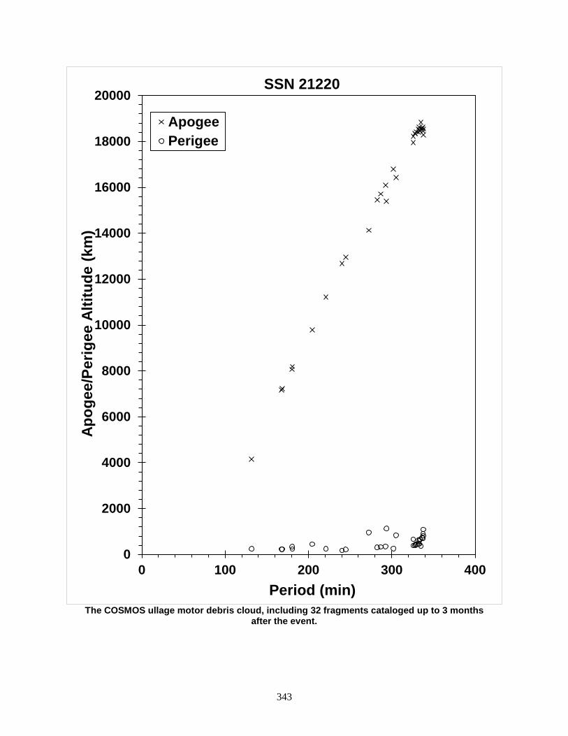
343
The COSMOS ullage motor debris cloud, including 32 fragments cataloged up to 3 months
after the event.
0
2000
4000
6000
8000
10000
12000
14000
16000
18000
20000
0 100 200 300 400
Apog
ee/P
erig
ee A
ltitu
de (k
m)
Period (min)
SSN 21220
ApogeePerigee
344
COSMOS 2139-2141 ULLAGE MOTOR 1991-025G 21226
SATELLITE DATA TYPE: Mission Related Debris OWNER: CIS LAUNCH DATE: 4.45 Apr 1991 DRY MASS (KG): ~55 MAIN BODY: Ellipsoid; 0.6 m diameter by 1.0 m length MAJOR APPENDAGES: None ATTITUDE CONTROL: None ENERGY SOURCES: On-board propellants EVENT DATA DATE: 16 Jun 2001 LOCATION: Unknown TIME: ~0700Z ASSESSED CAUSE: Propulsion ALTITUDE: Unknown PRE-EVENT ELEMENTS EPOCH: 01165.32627059 MEAN ANOMALY: 158.6980 RIGHT ASCENSION: 118.5521 MEAN MOTION: 4.28587592 INCLINATION: 64.5545 MEAN MOTION DOT/2: 0.00004370 ECCENTRICITY: 0.5826262 MEAN MOTION DOT DOT/6: 0.0 ARG. OF PERIGEE: 187.0212 BSTAR: 0.0011075 DEBRIS CLOUD DATA MAXIMUM ∆P: 236.7 min* MAXIMUM ∆I: 2.13 deg* * Based on uncataloged debris data COMMENTS The debris from this breakup were difficult for the US Space Surveillance Network to track. Although over 100 debris were initially tracked, none were cataloged. This is the 24th event of the Proton Block DM SOZ ullage motor since 1984. This ullage motor was launched prior to Russian recognition of the problem and before implementation of preventive measures. REFERENCE DOCUMENT “Two More Satellite Breakups Detected”, The Orbital Debris Quarterly News, NASA JSC, July 2001. Available online at https://orbitaldebris.jsc.nasa.gov/quarterly-news/pdfs/ODQNv6i3.pdf.

345
Cosmos 2139-41 auxiliary motor debris cloud of 77 fragments within 2 weeks after the
event as reconstructed from the US SSN database.
0
5000
10000
15000
20000
25000
30000
35000
50 150 250 350 450
Apog
ee/P
erig
ee A
ltitu
de (k
m)
Period (min)
Apogee
Perigee
SSN 21226

346
COSMOS 2157-2162 R/B 1991-068G 21734 SATELLITE DATA TYPE: Tsyklon Third Stage OWNER: CIS LAUNCH DATE: 28.30 Sep 1991 DRY MASS (KG): 1360 MAIN BODY: Cone-cylinder; 2.1 m diameter by 2.4 m length MAJOR APPENDAGES: None ATTITUDE CONTROL: None ENERGY SOURCES: Unknown EVENT DATA DATE: 09 Oct 1999 LOCATION: 41.5N, 217.9E (dsc) TIME: 1508 GMT ASSESSED CAUSE: Propulsion ALTITUDE: 1460 km PRE-EVENT ELEMENTS EPOCH: 99281.98318497 MEAN ANOMALY: 220.2415 RIGHT ASCENSION: 96.5043 MEAN MOTION: 12.54216420 INCLINATION: 82.5731 MEAN MOTION DOT/2: 0.00000027 ECCENTRICITY: 0.0046780 MEAN MOTION DOT DOT/6: 0.0 ARG. OF PERIGEE: 140.1600 BSTAR: 0.00010000 DEBRIS CLOUD DATA MAXIMUM ∆P: 2.716 min MAXIMUM ∆I: 0.79 deg COMMENTS This is the 4th event of this class identified to date and the second of 1999. All stages have been about 8-10 years old at the time of breakup. The vehicle is a Ukrainian-produced stage, using UDMH and N2O4 as propellants. To date these stages have not been passivated at end of mission and may contain up to 300 kg of residual propellants. The issue of Tsyklon orbital stage breakups was discussed with representatives of the National Space Agency of Ukraine during 11-13 October 1999 in Darmstadt, Germany. More than 100 of these stages are currently in Earth orbit. Although the exact cause of these breakups remains unknown, all four events have occurred during periods of high solar flux, i.e., near solar maximum. REFERENCE DOCUMENT “Third Tsyklon Upper Stage Breaks Up”, The Orbital Debris Quarterly News, NASA JSC, July 1999. Available online at https://orbitaldebris.jsc.nasa.gov/quarterly-news/pdfs/ODQNv4i3.pdf.
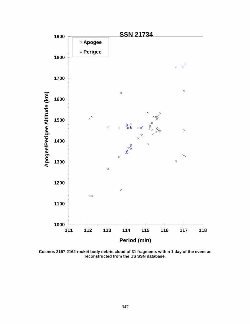
347
Cosmos 2157-2162 rocket body debris cloud of 31 fragments within 1 day of the event as
reconstructed from the US SSN database.
1000
1100
1200
1300
1400
1500
1600
1700
1800
1900
111 112 113 114 115 116 117 118
Apog
ee/P
erig
ee A
ltitu
de (k
m)
Period (min)
Apogee
Perigee
SSN 21734
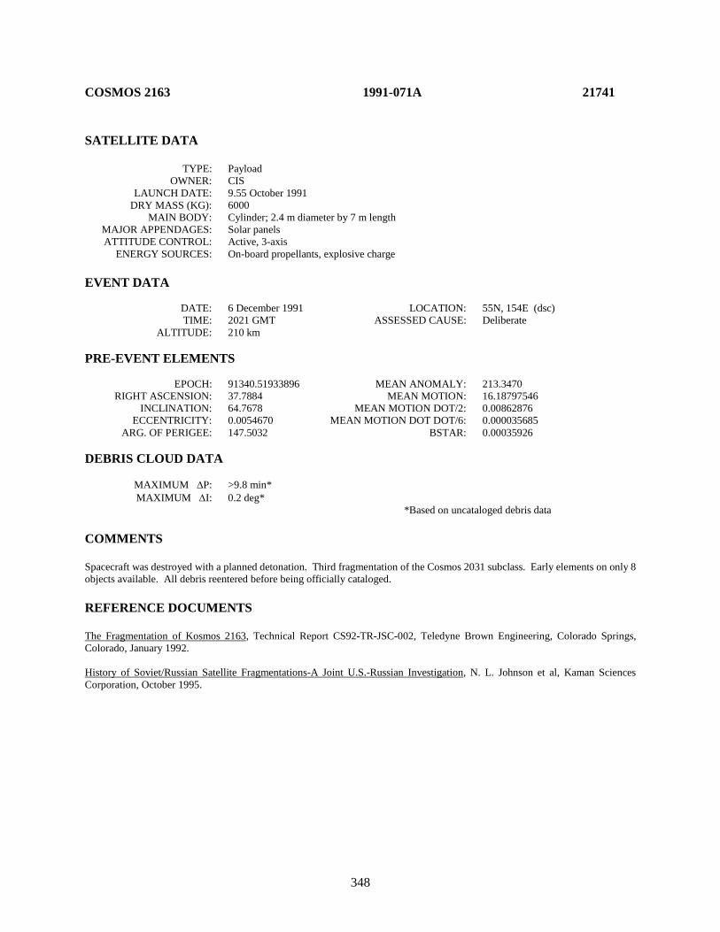
348
COSMOS 2163 1991-071A 21741 SATELLITE DATA TYPE: Payload OWNER: CIS LAUNCH DATE: 9.55 October 1991 DRY MASS (KG): 6000 MAIN BODY: Cylinder; 2.4 m diameter by 7 m length MAJOR APPENDAGES: Solar panels ATTITUDE CONTROL: Active, 3-axis ENERGY SOURCES: On-board propellants, explosive charge EVENT DATA DATE: 6 December 1991 LOCATION: 55N, 154E (dsc) TIME: 2021 GMT ASSESSED CAUSE: Deliberate ALTITUDE: 210 km PRE-EVENT ELEMENTS EPOCH: 91340.51933896 MEAN ANOMALY: 213.3470 RIGHT ASCENSION: 37.7884 MEAN MOTION: 16.18797546 INCLINATION: 64.7678 MEAN MOTION DOT/2: 0.00862876 ECCENTRICITY: 0.0054670 MEAN MOTION DOT DOT/6: 0.000035685 ARG. OF PERIGEE: 147.5032 BSTAR: 0.00035926 DEBRIS CLOUD DATA MAXIMUM ∆P: >9.8 min* MAXIMUM ∆I: 0.2 deg* *Based on uncataloged debris data COMMENTS Spacecraft was destroyed with a planned detonation. Third fragmentation of the Cosmos 2031 subclass. Early elements on only 8 objects available. All debris reentered before being officially cataloged. REFERENCE DOCUMENTS The Fragmentation of Kosmos 2163, Technical Report CS92-TR-JSC-002, Teledyne Brown Engineering, Colorado Springs, Colorado, January 1992. History of Soviet/Russian Satellite Fragmentations-A Joint U.S.-Russian Investigation, N. L. Johnson et al, Kaman Sciences Corporation, October 1995.

349
Cosmos 2163 debris cloud remnant of 8 objects 1 day after the event as reconstructed from the US SSN database. This diagram is taken from the cited reference.
0
100
200
300
400
500
600
700
800
87 89 91 93
Apog
ee/P
erig
ee A
ltitu
de (k
m)
Period (min)
Apogee
Perigee
SSN 21741

350
INTELSAT 601 R/B 1991-075B 21766 SATELLITE DATA TYPE: Ariane 4 Third Stage OWNER: France LAUNCH DATE: 29.96 Oct 1991 DRY MASS (KG): ~1760 MAIN BODY: Cylinder: 2.6 m diameter by 11.4 m length MAJOR APPENDAGES: None ATTITUDE CONTROL: None ENERGY SOURCES: On-board propellants EVENT DATA DATE: 24 Dec 2001 LOCATION: 4.0 N, 344.4 E (asc) TIME: ~2212Z ASSESSED CAUSE: Propulsion ALTITUDE: 22,100 km PRE-EVENT ELEMENTS EPOCH: 01358.15120659 MEAN ANOMALY: 1.1953 RIGHT ASCENSION: 264.6850 MEAN MOTION: 2.90501578 INCLINATION: 7.1968 MEAN MOTION DOT/2: 0.00042976 ECCENTRICITY: 0.6814056 MEAN MOTION DOT DOT/6: 0.0 ARG. OF PERIGEE: 351.9651 BSTAR: 0.0055981 DEBRIS CLOUD DATA MAXIMUM ∆P: 4.45 min* MAXIMUM ∆I: 0.08 deg* * Based on uncataloged debris data COMMENTS This 10-year-old Ariane 4 third stage appears to have suffered a minor fragmentation. The low inclination and high eccentricity of the orbit made debris detection and tracking difficult. Three pieces were initially detected by the SSN and ten objects cataloged a month after the event. The object was seen intact at about 2030 UTC, 24 December. Approximately 25 hours later a debris cloud of eight objects was seen by the same sensor. The perigee of the vehicle prior to breakup was sufficiently high that aerodynamic forces should not have been a factor in the event. REFERENCE DOCUMENT “Two Major Satellite Breakups Near End of 2001,” The Orbital Debris Quarterly News, NASA JSC, January 2002. Available online at https://orbitaldebris.jsc.nasa.gov/quarterly-news/pdfs/ODQNv7i1.pdf.

351
Intelsat 601 R/B debris cloud of 3 fragments 3 days after the breakup as reconstructed
from the US SSN database.
0
5000
10000
15000
20000
25000
30000
35000
489 490 491 492 493 494 495
Apog
ee/P
erig
ee A
ltitu
de (k
m)
Period (min)
Apogee
Perigee
SSN 21766
352
USA 73 1991-082A 21798 SATELLITE DATA TYPE: Payload OWNER: US LAUNCH DATE: 28.56 Nov 1991 DRY MASS (KG): 767 MAIN BODY: Cylinder; 1.0 m diameter by 3.6 m length MAJOR APPENDAGES: 1 solar panel ATTITUDE CONTROL: None at time of event ENERGY SOURCES: On-board propellant EVENT DATA DATE: 15 Apr 2004 LOCATION: 31N, 56E (asc) TIME: 1454 GMT ASSESSED CAUSE: Propulsion ALTITUDE: 835 km POST-EVENT ELEMENTS EPOCH: 04106.47330773 MEAN ANOMALY: 346.2855 RIGHT ASCENSION: 129.0059 MEAN MOTION: 14.15516644 INCLINATION: 98.6744 MEAN MOTION DOT/2: 0.00000244 ECCENTRICITY: .0012890 MEAN MOTION DOT DOT/6: 0.0 ARG. OF PERIGEE: 13.8671 BSTAR: 0.0014668 DEBRIS CLOUD DATA MAXIMUM ∆P: 2.8 min MAXIMUM ∆I: 0.4 deg COMMENTS The spacecraft was non-operational at the time of the event. The electrical power generation system had been passivated by discharging the batteries and disconnecting them from the charging circuit. Virtually no nitrogen remained on board due to a leak detected early in the mission. The only energy source assessed to be on the spacecraft at the time of the event was approximately 6 kg of hydrazine. REFERENCE DOCUMENT “Recent Satellite Breakups”, The Orbital Debris Quarterly News, NASA JSC, October 2004. Available online at https://orbitaldebris.jsc.nasa.gov/quarterly-news/pdfs/ODQNv8i4.pdf.
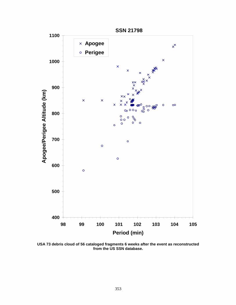
353
USA 73 debris cloud of 56 cataloged fragments 6 weeks after the event as reconstructed
from the US SSN database.
400
500
600
700
800
900
1000
1100
98 99 100 101 102 103 104 105
Period (min)
Apo
gee/
Perig
ee A
ltitu
de (k
m)
Apogee Perigee
SSN 21798
354
TELECOM 2B/INMARSAT 2 R/B 1992-021C 21941 SATELLITE DATA TYPE: Ariane 4 H10+ Third Stage OWNER: France LAUNCH DATE: 15.98 Apr 1992 DRY MASS (KG): 1800 MAIN BODY: Cylinder; 2.6 m diameter by 10 m length MAJOR APPENDAGES: None ATTITUDE CONTROL: None at time of the event. ENERGY SOURCES: On-board propellants EVENT DATA DATE: 21 Apr 1993 (EST) LOCATION: Unknown TIME: Unknown ASSESSED CAUSE: Propulsion ALTITUDE: Unknown PRE-EVENT ELEMENTS EPOCH: 93110.33659871 MEAN ANOMALY: 335.5551 RIGHT ASCENSION: 224.3451 MEAN MOTION: 2.28914093 INCLINATION: 4.03 MEAN MOTION DOT/2: 0.000024 ECCENTRICITY: 0.7248434 MEAN MOTION DOT DOT/6: 0.0 ARG. OF PERIGEE: 110.6851 BSTAR: 0.0020699 DEBRIS CLOUD DATA MAXIMUM ∆P: Unknown MAXIMUM ∆I: Unknown COMMENTS Although analysis indicates that 92-021C fragmented around 21 April 1993, the event was not recognized until eight pieces were cataloged during the period from 30 August 1994 to 2 September 1994. Naval Space Command reported that the eight objects were discovered during the period from July 1993 to July 1994.

355
Insufficient data to construct a Gabbard diagram.
356
INSAT 2A/EUTELSAT 2F4 R/B 1992-041C 22032 SATELLITE DATA TYPE: Ariane 4 H10 Final Stage OWNER: France LAUNCH DATE: 9.95 Jul 1992 DRY MASS (KG): ~1760 MAIN BODY: Cylinder: 2.6 m diameter by 11.4 m length MAJOR APPENDAGES: None ATTITUDE CONTROL: None ENERGY SOURCES: On-board propellants EVENT DATA DATE: Feb 2002 LOCATION: Unknown TIME: Unknown ASSESSED CAUSE: Propulsion ALTITUDE: Unknown PRE-EVENT ELEMENTS EPOCH: 02032.98792301 MEAN ANOMALY: 23.4497 RIGHT ASCENSION: 196.5922 MEAN MOTION: 3.10885568 INCLINATION: 7.0154 MEAN MOTION DOT/2: .00036687 ECCENTRICITY: .6663885 MEAN MOTION DOT DOT/6: .0 ARG. OF PERIGEE: 261.6162 BSTAR: .0 DEBRIS CLOUD DATA MAXIMUM ∆P: 41.05 min* MAXIMUM ∆I: 0.25 deg* * Based on uncataloged debris data COMMENTS This marks the sixth known fragmentation of an Ariane 4 third stage. The last three vehicles involved in such events (1988-109C, 1991-075C, and 1992-041C) had been in orbit 9-10 years at the time of their respective breakups. All flights were conducted prior to the implementation of passivation measures for Ariane GTO missions in September 1993. No Ariane launch vehicle launched since that time is known to have experienced an on-orbit fragmentation. REFERENCE DOCUMENT “Second Identified Satellite Breakup of 2002”, The Orbital Debris Quarterly News, NASA JSC, July 2002. Available online at https://orbitaldebris.jsc.nasa.gov/quarterly-news/pdfs/ODQNv7i3.pdf.
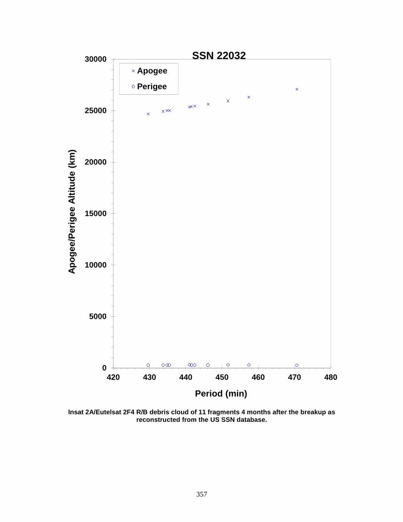
357
Insat 2A/Eutelsat 2F4 R/B debris cloud of 11 fragments 4 months after the breakup as
reconstructed from the US SSN database.
0
5000
10000
15000
20000
25000
30000
420 430 440 450 460 470 480
Apog
ee/P
erig
ee A
ltitu
de (k
m)
Period (min)
Apogee
Perigee
SSN 22032
358
COSMOS 2204-2206 ULLAGE MOTOR 1992-047G 22066 SATELLITE DATA TYPE: Mission Related Debris OWNER: CIS LAUNCH DATE: 30.08 Jul 1992 DRY MASS (KG): 55 MAIN BODY: Ellipsoid; 0.6 m diameter by 1 m length MAJOR APPENDAGES: None ATTITUDE CONTROL: None ENERGY SOURCES: On-board propellant EVENT DATA DATE: 10 Jul 2004 LOCATION: 34S, 240E (asc) TIME: 0240 GMT (est.) ASSESSED CAUSE: Propulsion ALTITUDE: 18,525 km POST-EVENT ELEMENTS EPOCH: 04190.17957430 MEAN ANOMALY: 263.0579 RIGHT ASCENSION: 223.5224 MEAN MOTION: 4.29145980 INCLINATION: 64.8832 MEAN MOTION DOT/2: 0.00005202 ECCENTRICITY: 0.5757033 MEAN MOTION DOT DOT/6: 0.0 ARG. OF PERIGEE: 149.3553 BSTAR: 0.0055262 DEBRIS CLOUD DATA MAXIMUM ∆P: 37.6 min MAXIMUM ∆I: 0.5 deg COMMENTS The object was in a decaying, eccentric orbit; this event marks the 30th known breakup of a Proton Block DM SOZ ullage motor since 1984. More than 100 debris were detected from Sat. No. 22066 by the US SSN. The sister SOZ motor for this launch broke up in an unrelated event ten years earlier (22067). REFERENCE DOCUMENT History of Soviet/Russian Satellite Fragmentations-A Joint U.S.-Russian Investigation, N. L. Johnson et al, Kaman Sciences Corporation, October 1995. “Recent Satellite Breakups”, The Orbital Debris Quarterly News, NASA JSC, October 2004. Available online at https://orbitaldebris.jsc.nasa.gov/quarterly-news/pdfs/ODQNv8i4.pdf.
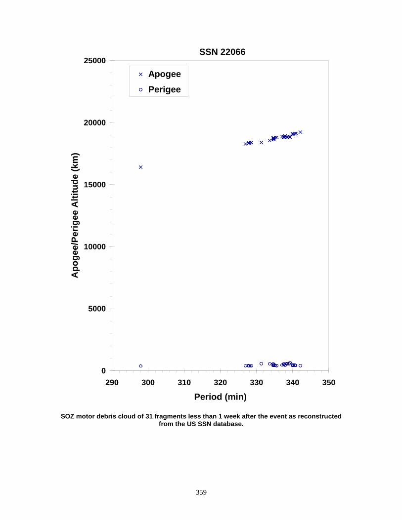
359
SOZ motor debris cloud of 31 fragments less than 1 week after the event as reconstructed
from the US SSN database.
0
5000
10000
15000
20000
25000
290 300 310 320 330 340 350
Period (min)
Apo
gee/
Perig
ee A
ltitu
de (k
m)
Apogee Perigee
SSN 22066

360
COSMOS 2204-2206 ULLAGE MOTOR 1992-047H 22067 SATELLITE DATA TYPE: Mission Related Debris OWNER: CIS LAUNCH DATE: 30.08 Jul 1992 DRY MASS (KG): 55 MAIN BODY: Ellipsoid; 0.6 m diameter by 1.0 m length MAJOR APPENDAGES: None ATTITUDE CONTROL: None ENERGY SOURCES: On-board propellants EVENT DATA DATE: Prior to 0824 GMT, 8 Nov 1994 LOCATION: Unknown TIME: Unknown ASSESSED CAUSE: Propulsion ALTITUDE: Unknown PRE-EVENT ELEMENTS EPOCH: 94310.28602258 MEAN ANOMALY: 9.8460 RIGHT ASCENSION: 65.2049 MEAN MOTION: 4.23571466 INCLINATION: 64.8556 MEAN MOTION DOT/2: 0.00001002 ECCENTRICITY: 0.5708388 MEAN MOTION DOT DOT/6: 0.0 ARG. OF PERIGEE: 316.7786 BSTAR: 0.0033777 DEBRIS CLOUD DATA MAXIMUM ∆P: 4.2 min MAXIMUM ∆I: 0.9 deg COMMENTS Parent satellite was one of two small engine units that are routinely released after the first burn of the Proton fourth stage. The nature of these objects was identified by Dr. Boris V. Cherniatiev, Deputy Constructor for the Energiya NPO and Mr. Nicholas Johnson of Kaman Sciences, in October, 1992. The cause of this fragmentation appears to be related to the residual hypergolic propellants on board and failure of the membrane separating the fuel and oxidizer. NAVSPASUR observed 32 objects that were associated with this breakup on 8 Nov 94, 36 objects on 9 Nov and 31 objects on 10 Nov. This was the tenth in a series of fragmentations of this object type. REFERENCE DOCUMENTS The Fragmentation of Proton Debris, D. J. Nauer, TBE Technical Report CS93-LKD-004, Teledyne Brown Engineering, Colorado Springs, 31 December 1992. Identification and Resolution of an Orbital Debris Problem with the Proton Launch Vehicle, B. V. Cherniatiev, et al, First European Conference on Space Debris, 5-7 April 1993. History of Soviet/Russian Satellite Fragmentations-A Joint U.S.-Russian Investigation, N. L. Johnson et al, Kaman Sciences Corporation, October 1995.

361
Gabbard Diagram from the Cosmos 2204-2206 debris fragmentation.
0
5000
10000
15000
20000
25000
337 339 341 343 345
Apog
ee/P
erig
ee A
ltitu
de (k
m)
Period (min)
Apogee
Perigee
SSN 22067

362
GORIZONT 27 ULLAGE MOTOR 1992-082F 22250 SATELLITE DATA TYPE: Mission Related Debris OWNER: CIS LAUNCH DATE: 27.55 Nov 1992 DRY MASS (KG): ~55 MAIN BODY: Ellipsoid; 0.6 m diameter by 1.0 m length MAJOR APPENDAGES: None ATTITUDE CONTROL: None ENERGY SOURCES: On-board propellants EVENT DATA DATE: 14 Jul 2001 LOCATION: Unknown TIME: ~1800Z ASSESSED CAUSE: Propulsion ALTITUDE: Unknown PRE-EVENT ELEMENTS EPOCH: 01194.12977223 MEAN ANOMALY: 232.1640 RIGHT ASCENSION: 101.3588 MEAN MOTION: 9.96766196 INCLINATION: 46.4697 MEAN MOTION DOT/2: 0.01023324 ECCENTRICITY: 0.2850325 MEAN MOTION DOT DOT/6: 0.0000014714 ARG. OF PERIGEE: 148.6125 BSTAR: 0.00050789 DEBRIS CLOUD DATA MAXIMUM ∆P: Unknown MAXIMUM ∆I: Unknown COMMENTS This event marks the 25th known breakup of a Proton Blok DM SOZ ullage motor since 1984. Due to the moderate eccentricity and altitude of the orbits, the debris were difficult for the US Space Surveillance Network to track. This ullage motor was launched before implementation of breakup preventive measures. No debris were cataloged from this breakup. REFERENCE DOCUMENT “New Satellite Breakups Detected”, The Orbital Debris Quarterly News, NASA JSC, October 2001. Available online at https://orbitaldebris.jsc.nasa.gov/quarterly-news/pdfs/ODQNv6i4.pdf.

363
Insufficient data to construct a Gabbard diagram.
364
COSMOS 2224 ULLAGE MOTOR 1992-088F 22274 SATELLITE DATA TYPE: Mission Related Debris OWNER: CIS LAUNCH DATE: 17.53 Dec 1992 DRY MASS (KG): 55 MAIN BODY: Ellipsoid; 0.6 m diameter by 1 m length MAJOR APPENDAGES: None ATTITUDE CONTROL: None ENERGY SOURCES: On-board propellant EVENT DATA DATE: ~22 Apr 2005 LOCATION: Unknown TIME: Unknown ASSESSED CAUSE: Propulsion ALTITUDE: Unknown PRE-EVENT ELEMENTS EPOCH: 05112.46798568 MEAN ANOMALY: 2.1228 RIGHT ASCENSION: 268.8209 MEAN MOTION: 3.90056983 INCLINATION: 46.7270 MEAN MOTION DOT/2: 0.00018984 ECCENTRICITY: 0.6142562 MEAN MOTION DOT DOT/6: 0.00000003 ARG. OF PERIGEE: 348.3165 BSTAR: 0.0006277 DEBRIS CLOUD DATA MAXIMUM ∆P: Unknown MAXIMUM ∆I: Unknown COMMENTS This event marks the 32nd known breakup of a Proton Blok DM SOZ ullage motor since 1984. This object had a perigee near 200 km. The event happened sometime between 1100 GMT on April 22, and 1200 GMT on April 23. Only about a dozen pieces were detected by the US SSN. REFERENCE DOCUMENT History of Soviet/Russian Satellite Fragmentations-A Joint U.S.-Russian Investigation, N. L. Johnson et al, Kaman Sciences Corporation, October 1995. “Recent Satellite Breakups”, The Orbital Debris Quarterly News, NASA JSC, July 2005. Available online at https://orbitaldebris.jsc.nasa.gov/quarterly-news/pdfs/ODQNv9i3.pdf.

365
Insufficient data to construct a Gabbard diagram.

366
COSMOS 2225 1992-091A 22280 SATELLITE DATA TYPE: Payload OWNER: CIS LAUNCH DATE: 22.50 Dec 1992 DRY MASS (KG): 6000 MAIN BODY: Cylinder; 2.4 m diameter by 7 m length MAJOR APPENDAGES: Solar panels ATTITUDE CONTROL: Active, 3-axis ENERGY SOURCES: On-board propellants, explosive charge EVENT DATA DATE: 18 Feb 1993 LOCATION: 55N, 157E (dsc) TIME: 1856 GMT ASSESSED CAUSE: Deliberate ALTITUDE: 220 km PRE-EVENT ELEMENTS EPOCH: 93040.89217375 MEAN ANOMALY: 244.5776 RIGHT ASCENSION: 125.1196 MEAN MOTION: 16.07940666 INCLINATION: 64.8919 MEAN MOTION DOT/2: 0.00301303 ECCENTRICITY: 0.0039285 MEAN MOTION DOT DOT/6: 0.000049705 ARG. OF PERIGEE: 115.8892 BSTAR: 0.00032572 DEBRIS CLOUD DATA MAXIMUM ∆P: > 2.3 min MAXIMUM ∆I: > 0.5 deg COMMENTS Spacecraft was destroyed with a planned detonation. Fourth fragmentation of the Cosmos 2031 subclass. Early elements on only 10 objects (including the parent) available; 21 objects were observed by Fylingdales soon after the event. REFERENCE DOCUMENTS Analysis of Fragmentations from December 1992 - February 1993, Technical Report CS93-LKD-010, Teledyne Brown Engineering, Colorado Springs, Colorado, 30 March 1993. History of Soviet/Russian Satellite Fragmentations-A Joint U.S.-Russian Investigation, N. L. Johnson et al, Kaman Sciences Corporation, October 1995.
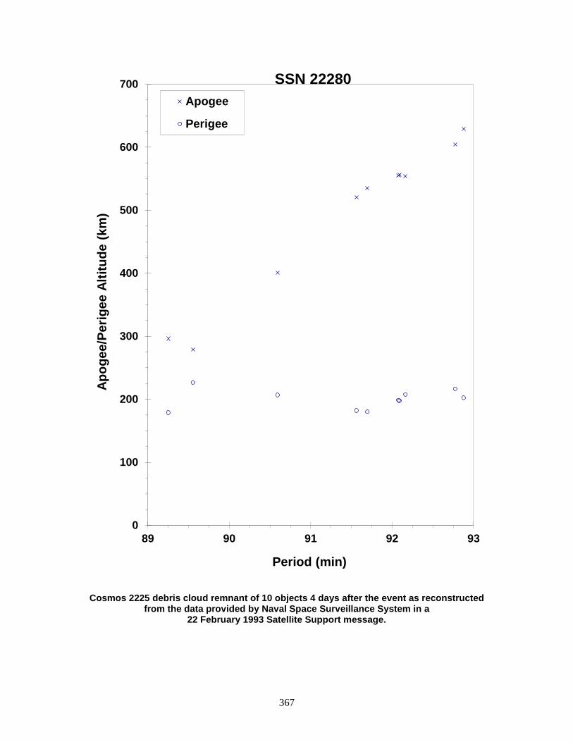
367
Cosmos 2225 debris cloud remnant of 10 objects 4 days after the event as reconstructed from the data provided by Naval Space Surveillance System in a
22 February 1993 Satellite Support message.
0
100
200
300
400
500
600
700
89 90 91 92 93
Apog
ee/P
erig
ee A
ltitu
de (k
m)
Period (min)
Apogee
Perigee
SSN 22280
368
COSMOS 2227 R/B 1992-093B 22285 SATELLITE DATA TYPE: Zenit Second Stage OWNER: CIS LAUNCH DATE: 25.25 Dec 1992 DRY MASS (KG): 8300 MAIN BODY: Cylinder; 3.9 m diameter by 12 m length MAJOR APPENDAGES: None ATTITUDE CONTROL: None at time of the event. ENERGY SOURCES: On-board propellants (~900 kg), explosive charge (?) EVENT DATA (1) DATE: 26 Dec 1992 LOCATION: 63 N, 60 E (asc) TIME: 0738 GMT ASSESSED CAUSE: Propulsion ALTITUDE: 830 km Note: NAVSPASUR could not correlate with 22285, but 22285 was closest object. EVENT DATA (2) DATE: 26 Dec 1992 LOCATION: 44 N, 168 E (asc) TIME: 2249 GMT ASSESSED CAUSE: Unknown ALTITUDE: 830 km EVENT DATA (3) DATE: 26 Dec 1992 LOCATION: 52 N, 63 E (dsc) TIME: 2310 GMT ASSESSED CAUSE: Unknown ALTITUDE: 835 km EVENT DATA (4) DATE: 30 Dec 1992 LOCATION: 22 S, 172 E (dsc) TIME: 0903 GMT ASSESSED CAUSE: Propulsion ALTITUDE: ~ 830 km PRE-EVENT ELEMENTS TO EVENT 1 EPOCH: 92361.30431818 MEAN ANOMALY: 289.8749 RIGHT ASCENSION: 227.4354 MEAN MOTION: 14.1258288 INCLINATION: 71.0274 MEAN MOTION DOT/2: -0.00061925 ECCENTRICITY: 0.0005311 MEAN MOTION DOT DOT/6: 0.0 ARG. OF PERIGEE: 71.7543 BSTAR: -0.034134 DEBRIS CLOUD DATA MAXIMUM ∆P: 4.3 min * MAXIMUM ∆I: 1.4 deg * * Based upon comparison to pre-event elements, includes all four events, based upon cataloged elements only. COMMENTS Four separate events were reported by NAVSPASUR. The first observed event was accompanied by an initial 18 objects, but could not be correlated with the rocket body element set. The rocket body was the closest object to the BLAST point. The second event followed 15 hours later with 96 objects. The third event followed the second by less than 20 minutes and was based upon 51 pieces. The fourth event was accompanied by 3 objects. Element data on 164 objects has been combined into a single Gabbard Diagram.
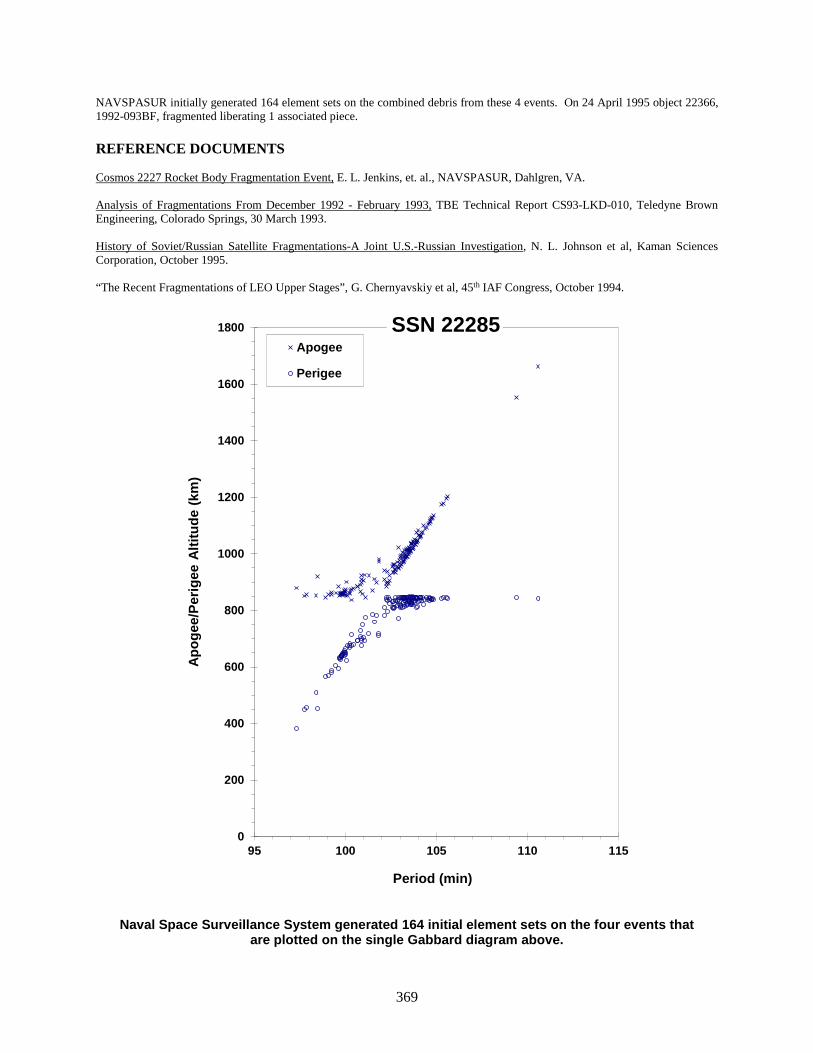
369
NAVSPASUR initially generated 164 element sets on the combined debris from these 4 events. On 24 April 1995 object 22366, 1992-093BF, fragmented liberating 1 associated piece. REFERENCE DOCUMENTS Cosmos 2227 Rocket Body Fragmentation Event, E. L. Jenkins, et. al., NAVSPASUR, Dahlgren, VA. Analysis of Fragmentations From December 1992 - February 1993, TBE Technical Report CS93-LKD-010, Teledyne Brown Engineering, Colorado Springs, 30 March 1993. History of Soviet/Russian Satellite Fragmentations-A Joint U.S.-Russian Investigation, N. L. Johnson et al, Kaman Sciences Corporation, October 1995. “The Recent Fragmentations of LEO Upper Stages”, G. Chernyavskiy et al, 45th IAF Congress, October 1994.
Naval Space Surveillance System generated 164 initial element sets on the four events that are plotted on the single Gabbard diagram above.
0
200
400
600
800
1000
1200
1400
1600
1800
95 100 105 110 115
Apog
ee/P
erig
ee A
ltitu
de (k
m)
Period (min)
Apogee
Perigee
SSN 22285
370
COSMOS 2237 R/B 1993-016B 22566 SATELLITE DATA TYPE: Zenit Second Stage OWNER: CIS LAUNCH DATE: 26.10 Mar 1993 DRY MASS (KG): 8300 MAIN BODY: Cylinder; 3.9 m diameter by 12 m length MAJOR APPENDAGES: None ATTITUDE CONTROL: None ENERGY SOURCES: On-board propellants (~900 kg), explosive charge (?) EVENT DATA DATE: 28 Mar 1993 LOCATION: 70N, 37E (dsc) TIME: 0716 GMT ASSESSED CAUSE: Propulsion ALTITUDE: 840 km PRE-EVENT ELEMENTS EPOCH: 93088.27687915 MEAN ANOMALY: 84.1791 RIGHT ASCENSION: 258.8192 MEAN MOTION: 14.14093359 INCLINATION: 70.9947 MEAN MOTION DOT/2: 0.00255882 ECCENTRICITY: 0.0006748 MEAN MOTION DOT DOT/6: 0.0 ARG. OF PERIGEE: 275.8565 BSTAR: 0.12879 DEBRIS CLOUD DATA MAXIMUM ∆P: 3.5 min MAXIMUM ∆I: 0.1 deg COMMENTS At least 26 initial element sets were generated on this event by NAVSPASUR. The BLAST point was calculated from 12 objects. REFERENCE DOCUMENTS The Fragmentation of the Cosmos 2237 & 2243 Rocket Bodies, D. J. Nauer, TBE Technical Report CS93-LKD-016, Teledyne Brown Engineering, Colorado Springs, 15 June 1993. History of Soviet/Russian Satellite Fragmentations-A Joint U.S.-Russian Investigation, N. L. Johnson et al, Kaman Sciences Corporation, October 1995. “The Recent Fragmentations of LEO Upper Stages”, G. Chernyavskiy et al, 45th IAF Congress, October 1994.

371
Naval Space Surveillance System generated 24 initial element sets that are plotted on the Gabbard diagram above.
600
700
800
900
1000
1100
1200
102 103 104 105 106
Apog
ee/P
erig
ee A
ltitu
de (k
m)
Period (min)
Apogee
Perigee
SSN 22566
372
COSMOS 2238 1993-018A 22585 SATELLITE DATA TYPE: Payload OWNER: CIS LAUNCH DATE: 30.50 Mar 1993 DRY MASS (KG): 3000 MAIN BODY: Cylinder; 1.3 m diameter by 17 m length MAJOR APPENDAGES: Solar panels ATTITUDE CONTROL: Active, 3-axis ENERGY SOURCES: On-board propellants, explosive charge (?) EVENT DATA DATE: 1 Dec 1994 LOCATION: 6.5 S, 243.0 E (dsc) TIME: 1111 GMT ASSESSED CAUSE: Unknown ALTITUDE: 275 km PRE-EVENT ELEMENTS EPOCH: 94335.21831221 MEAN ANOMALY: 119.6648 RIGHT ASCENSION: 124.7826 MEAN MOTION: 16.06466469 INCLINATION: 65.0063 MEAN MOTION DOT/2: 0.00787680 ECCENTRICITY: 0.0069696 MEAN MOTION DOT DOT/6: 0.0000095760 ARG. OF PERIGEE: 239.7651 BSTAR: 0.00073936 DEBRIS CLOUD DATA MAXIMUM ∆P: Unknown MAXIMUM ∆I: Unknown COMMENTS Cosmos 2238 was a member of the Cosmos 699-type and the first such spacecraft to breakup for 7 years. As many as 26 debris were detected; however, additional debris probably decayed before they were observed. Cosmos is the 17th fragmentation of a Cosmos 699 class payload.

373
Insufficient data to construct a Gabbard diagram.
374
COSMOS 2243 1993-028A 22641 SATELLITE DATA TYPE: Payload OWNER: CIS LAUNCH DATE: 27.44 Apr 1993 DRY MASS (KG): 5700 MAIN BODY: Cone-cylinder; 2.7 m diameter by 6.3 m length MAJOR APPENDAGES: Solar panels ATTITUDE CONTROL: Active, 3-axis ENERGY SOURCES: On-board propellants, explosive charge EVENT DATA DATE: 27 Apr 1993 LOCATION: 61N, 81E (asc) TIME: 1044 GMT ASSESSED CAUSE: Deliberate ALTITUDE: 200 km PRE-EVENT ELEMENTS * EPOCH: 93119.28633059 MEAN ANOMALY: 283.6524 RIGHT ASCENSION: 51.8515 MEAN MOTION: 16.26199828 INCLINATION: 70.3602 MEAN MOTION DOT/2: 0.02823100 ECCENTRICITY: 0.0032877 MEAN MOTION DOT DOT/6: 0.000019668 ARG. OF PERIGEE: 76.8057 BSTAR: 0.00077017 * Note: Element Set 1 not generated until ~2 days after the event. DEBRIS CLOUD DATA MAXIMUM ∆P: 7.1 min MAXIMUM ∆I: 0.4 deg COMMENTS Although this event was originally thought to be a fragmentation of the Soyuz final stage rocket body, it was actually the payload that fragmented. This event occurred near orbital insertion into the operational orbit. It is unclear whether the payload was attached at the time of the event. The payload malfunctioned and self-destructed. There were 25 initial element sets available after launch. NAVSPASUR reported tracking approximately 27 objects on 30 April 1993, and detected as many as 20 more unknowns. The final official piece count associated with this event was 172 objects. Due to the very low altitude, most objects decayed from this cloud within 2 weeks of launch. No cataloged element sets were released until almost 2 days after the event. REFERENCE DOCUMENTS The Fragmentation of the Cosmos 2237 & 2243 Rocket Bodies, D. J. Nauer, TBE Technical Report CS93-LKD-016, Teledyne Brown Engineering, Colorado Springs, 15 June 1993. History of Soviet/Russian Satellite Fragmentations-A Joint U.S.-Russian Investigation, N. L. Johnson et al, Kaman Sciences Corporation, October 1995.
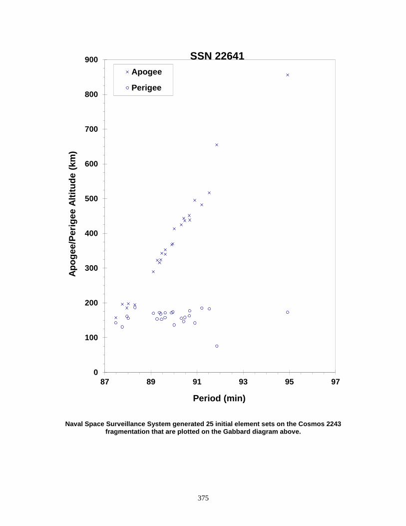
375
Naval Space Surveillance System generated 25 initial element sets on the Cosmos 2243 fragmentation that are plotted on the Gabbard diagram above.
0
100
200
300
400
500
600
700
800
900
87 89 91 93 95 97
Apog
ee/P
erig
ee A
ltitu
de (k
m)
Period (min)
Apogee
Perigee
SSN 22641

376
COSMOS 2251 1993-036A 22675 SATELLITE DATA TYPE: Payload OWNER: CIS LAUNCH DATE: 16 Jun 1993 DRY MASS (KG): 900 MAIN BODY: cylinder; 2.035 m diameter x 2 m length MAJOR APPENDAGES: gravity gradient boom ATTITUDE CONTROL: gravity gradient (passive) ENERGY SOURCES: pressurized vessel; chemical batteries EVENT DATA DATE: 10 Feb 2009 LOCATION: 72.5N, 97.9E (asc) TIME: 1656 GMT ASSESSED CAUSE: Collision ALTITUDE: 788.597 km PRE-EVENT ELEMENTS EPOCH: 09040.49834364 MEAN ANOMALY: 261.5952 RIGHT ASCENSION: 19.4646 MEAN MOTION: 14.31135643 INCLINATION: 74.0355 MEAN MOTION DOT/2: -0.00000001 ECCENTRICITY: 0.0016027 MEAN MOTION DOT DOT/6: 0.0 ARG. OF PERIGEE: 98.7014 BSTAR: 0.0000095251 DEBRIS CLOUD DATA MAXIMUM ∆P: 9.4 min MAXIMUM ∆I: 24.7 deg COMMENTS The spacecraft, a member of the Soviet/Russian Strela-2M low-altitude communications satellite constellation, utilized the versatile KAUR-1 bus (Kosmicheskiy Apparat Universalnogo Ryada-1, (Космический Аппарат Универсального Ряда), which can be translated as Spacecraft Bus from the Standardized Line-1). This bus consists of a central pressurized cylinder for the payload, an outer cylinder mounting solar cells (the Solar Battery), and a gravity gradient boom for passive stabilization. The spacecraft was derelict at the time of the event. Cosmos 2251 collided with Iridium 33 [q.v.] in the first, accidental collision of large, intact resident space objects. REFERENCE DOCUMENT “Satellite Collision Leaves Significant Debris Clouds”, The Orbital Debris Quarterly News, NASA JSC, April 2009. Available online at https://orbitaldebris.jsc.nasa.gov/quarterly-news/ODQNv13i2.pdf.

377
The COSMOS 2251 debris cloud, including 1648 fragments cataloged up to 5 years after
the event.
0
200
400
600
800
1000
1200
1400
1600
1800
90 95 100 105 110 115
Apog
ee/P
erig
ee A
ltitu
de (k
m)
Period (min)
SSN 22675
Apogee (up to 5 yrs post BU)Perigee (up to 5 yrs post BU)Apogee (up to 3 wks post BU)Perigee (up to 3 wks post BU)
378
COSMOS 2259 1993-045A 22716 SATELLITE DATA TYPE: Payload OWNER: CIS LAUNCH DATE: 14.69 Jul 1993 DRY MASS (KG): 5700 MAIN BODY: Cone-cylinder; 2.7 m diameter by 6.3 m length MAJOR APPENDAGES: Solar panels ATTITUDE CONTROL: Active, 3-axis ENERGY SOURCES: On-board propellants, explosive charge EVENT DATA DATE: 25 Jul 1993 LOCATION: Unknown TIME: Unknown ASSESSED CAUSE: Deliberate ALTITUDE: Unknown PRE-EVENT ELEMENTS EPOCH: 93205.96411483 MEAN ANOMALY: 292.3177 RIGHT ASCENSION: 134.4696 MEAN MOTION: 16.09525981 INCLINATION: 67.1310 MEAN MOTION DOT/2: 0.00638090 ECCENTRICITY: 0.0113387 MEAN MOTION DOT DOT/6: 0.000023099 ARG. OF PERIGEE: 68.9805 BSTAR: 0.00025239 DEBRIS CLOUD DATA MAXIMUM ∆P: Unknown MAXIMUM ∆I: Unknown COMMENTS Spacecraft was destroyed after a malfunction prevented reentry and landing in the CIS. Event identified by Russian officials during investigation cited below. REFERENCE DOCUMENT History of Soviet/Russian Satellite Fragmentations-A Joint U.S.-Russian Investigation, N. L. Johnson et al, Kaman Sciences Corporation, October 1995.

379
Insufficient data to construct a Gabbard diagram.

380
COSMOS 2262 1993-057A 22789 SATELLITE DATA TYPE: Payload OWNER: CIS LAUNCH DATE: 7.56 Sep 1993 DRY MASS (KG): 6000 MAIN BODY: Cylinder; 2.4 m diameter by 7 m length MAJOR APPENDAGES: Solar panels ATTITUDE CONTROL: Active, 3-axis ENERGY SOURCES: On-board propellants, explosive charge EVENT DATA DATE: 18 Dec 1993 LOCATION: 65N, 107E (dsc) TIME: 0711 GMT ASSESSED CAUSE: Deliberate ALTITUDE: 195 km PRE-EVENT ELEMENTS EPOCH: 93352.09835999 MEAN ANOMALY: 294.6647 RIGHT ASCENSION: 209.9170 MEAN MOTION: 16.17608693 INCLINATION: 64.8761 MEAN MOTION DOT/2: 0.00554324 ECCENTRICITY: 0.0065884 MEAN MOTION DOT DOT/6: 0.0 ARG. OF PERIGEE: 66.1310 BSTAR: 0.00022099 DEBRIS CLOUD DATA MAXIMUM ∆P: 8.7 min * MAXIMUM ∆I: 0.8 deg * * Based on uncataloged debris data COMMENTS Spacecraft was destroyed with a planned detonation. Fifth fragmentation of this sub-type (Cosmos 2031 subclass). Early elements on 43 objects (including the parent) were collected; at least 179 objects were reported by the NAVSPOC for early passes through the NAVSPASUR fence. REFERENCE DOCUMENTS The Fragmentation of Cosmos 2262, Technical Report CS94-LKD-006, Teledyne Brown Engineering, Colorado Springs, Colorado, 31 December 1993. History of Soviet/Russian Satellite Fragmentations-A Joint U.S.-Russian Investigation, N. L. Johnson et al, Kaman Sciences Corporation, October 1995.

381
Cosmos 2262 debris cloud based upon 43 early element sets provided by the NAVSPOC.
0
200
400
600
800
1000
1200
85 90 95 100
Apog
ee/P
erig
ee A
ltitu
de (k
m)
Period (min)
Apogee
Perigee
SSN 22789

382
GORIZONT 29 ULLAGE MOTOR 1993-072E 22925 SATELLITE DATA TYPE: Proton Block DM SOZ Ullage Motor OWNER: CIS LAUNCH DATE: 18.58 Nov 1993 DRY MASS (KG): ~55 kg MAIN BODY: ~0.6 m by 0.6 m by 1.0 m MAJOR APPENDAGES: None ATTITUDE CONTROL: None ENERGY SOURCES: On-board propellants? EVENT DATA DATE: 6-7 Sep 2000 LOCATION: Unknown TIME: between 1918–0253 GMT ASSESSED CAUSE: Propulsion ALTITUDE: Unknown PRE-EVENT ELEMENTS EPOCH: 00250.18110680 MEAN ANOMALY: 305.0033 RIGHT ASCENSION: 135.7916 MEAN MOTION: 6.55809618 INCLINATION: 46.7439 MEAN MOTION DOT/2: 0.00601672 ECCENTRICITY: 0.4592082 MEAN MOTION DOT DOT/6: 0.00000031378 ARG. OF PERIGEE: 109.1361 BSTAR: 0.00059159 DEBRIS CLOUD DATA MAXIMUM ∆P: Unknown MAXIMUM ∆I: Unknown COMMENTS This is the 22nd breakup event for an object of this class, and the first of the year 2000. The breakups are assessed to be caused by residual propellants. Russian officials have been aware of the problem since 1992 and have made design changes, although the date of full implementation is unknown. The environmental consequence of the breakup will be short-lived; the object is in catastrophic decay from a geosynchronous transfer orbit. Latest estimate of the breakup time is between 1918 GMT, 6 September and 0253 GMT, 7 September. REFERENCE DOCUMENT “September Breakup is 22nd in Series”, The Orbital Debris Quarterly News, NASA JSC, October 2000. Available online at https://orbitaldebris.jsc.nasa.gov/quarterly-news/pdfs/ODQNv5i4.pdf.

383
Insufficient data to construct a Gabbard diagram.
384
CLEMENTINE R/B 1994-004B 22974 SATELLITE DATA TYPE: Titan II Second Stage OWNER: US LAUNCH DATE: 25.69 Jan 1994 DRY MASS (KG): 2860 MAIN BODY: Cylinder; 3.048 m diameter x 7.3 m length MAJOR APPENDAGES: None ATTITUDE CONTROL: None at time of the event. ENERGY SOURCES: On-board propellants EVENT DATA DATE: 7 Feb 1994 LOCATION: 59S, 234E (dsc) TIME: 1719 GMT ASSESSED CAUSE: Propulsion ALTITUDE: 260 km PRE-EVENT ELEMENTS EPOCH: 94038.24510489 MEAN ANOMALY: 208.0182 RIGHT ASCENSION: 47.9208 MEAN MOTION: 16.13665058 INCLINATION: 66.9945 MEAN MOTION DOT/2: 0.01050211 ECCENTRICITY: 0.0027030 MEAN MOTION DOT DOT/6: 0.0000059221 ARG. OF PERIGEE: 152.2460 BSTAR: 0.00081413 DEBRIS CLOUD DATA MAXIMUM ∆P: 5.6 min * MAXIMUM ∆I: 0.6 deg * * Based on uncataloged debris data COMMENTS First Titan II Second Stage to violently fragment. NAVSPOC reported observing a maximum of 364 objects in the early debris cloud, and the NAVSPOC released 45 element sets. Engineering analysis by the manufacturer (Martin Marietta) indicates no known failure mechanism, although unspent on-board propellants were present. REFERENCE DOCUMENT The Fragmentation of the Clementine Rocket Body, TBE Technical Report CS94-LKD-010, Teledyne Brown Engineering, Colorado Springs, Colorado, 31 March 1994.
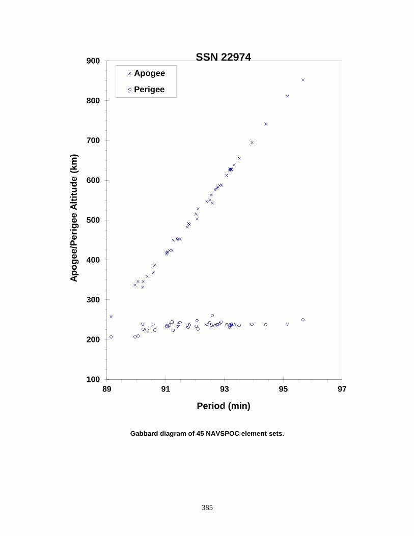
385
Gabbard diagram of 45 NAVSPOC element sets.
100
200
300
400
500
600
700
800
900
89 91 93 95 97
Apog
ee/P
erig
ee A
ltitu
de (k
m)
Period (min)
Apogee
Perigee
SSN 22974
386
STEP II R/B 1994-029B 23106 SATELLITE DATA TYPE: Pegasus HAPS OWNER: USA LAUNCH DATE: 19.71 May 1994 DRY MASS (KG): 97 MAIN BODY: Cylinder; 0.97 m diameter by 0.93 m length MAJOR APPENDAGES: None ATTITUDE CONTROL: None at time of the event. ENERGY SOURCES: On-board propellants and pressurants EVENT DATA DATE: 3 Jun 1996 LOCATION: 67 S, 56 E (asc) TIME: 1518 GMT ASSESSED CAUSE: Propulsion ALTITUDE: 625 km PRE-EVENT ELEMENTS EPOCH: 96155.10100506 MEAN ANOMALY: 108.3711 RIGHT ASCENSION: 197.8565 MEAN MOTION: 14.56780581 INCLINATION: 81.9749 MEAN MOTION DOT/2: 0.00000158 ECCENTRICITY: 0.0165742 MEAN MOTION DOT DOT/6: 0 ARG. OF PERIGEE: 249.9583 BSTAR: 0.000025815 DEBRIS CLOUD DATA MAXIMUM ∆P: 27.9 min MAXIMUM ∆I: 2.4 deg COMMENTS The Pegasus Hydrazine Auxiliary Propulsion Stage (HAPS) was employed for only the second time. It failed to place its payload into the assigned circular orbit and had an estimated 5-8 kg of residual propellant plus propellant for attitude control on board. The fragmentation of the small, 2-year-old upper stage produced a record number (to that time) of more than 750 tracked debris, and necessitated the addition of a third place in the piece tag format in two line element sets. This is about an order of magnitude more than can be expected for the small dry mass of the R/B of 97 kg. Observations suggest that the debris are physically small with a high radar reflectivity. Investigations suggest that a regulator failure led to overpressurization of the propellant tank that in turn ruptured. REFERENCE DOCUMENT “Major Satellite Breakup in June”, N. Johnson, Orbital Debris Quarterly News, NASA JSC, September 1996, p. 2 and 11. Available online at https://orbitaldebris.jsc.nasa.gov/quarterly-news/pdfs/ODQNV1i2.pdf.

387
Step II R/B debris cloud of 713 fragments as of August 29, 1996 as reconstructed from the US SSN database.
0
500
1000
1500
2000
2500
3000
90 95 100 105 110 115 120
Apog
ee/P
erig
ee A
ltitu
de (k
m)
Period (min)
Apogee
Perigee
SSN 23106

388
COSMOS 2282 ULLAGE MOTOR 1994-038F 23174 SATELLITE DATA TYPE: Mission Related Debris OWNER: CIS LAUNCH DATE: 6.99+ Jul 1994 DRY MASS (KG): 55 MAIN BODY: Ellipsoid; 0.6 m diameter by 1 m length MAJOR APPENDAGES: None ATTITUDE CONTROL: None ENERGY SOURCES: On-board propellants EVENT DATA DATE: Approx. 21 Oct 1995 LOCATION: Unknown TIME: Unknown ASSESSED CAUSE: Propulsion ALTITUDE: Unknown PRE-EVENT ELEMENTS EPOCH: 95293.99530492 MEAN ANOMALY: 2.33725319 RIGHT ASCENSION: 157.0951 MEAN MOTION: 321.8211 INCLINATION: 47.0485 MEAN MOTION DOT/2: 0.00002472 ECCENTRICITY: 0.7223127 MEAN MOTION DOT DOT/6: 0.0000 ARG. OF PERIGEE: 127.9520 BSTAR: 0.0010694 DEBRIS CLOUD DATA MAXIMUM ∆P: Unknown MAXIMUM ∆I: Unknown COMMENTS Parent satellite was one of two small engine units that are routinely released after the first burn of the Proton fourth stage. The nature of these objects was identified by Dr. Boris V. Chernlatiev, Deputy Constructor for the Energiya NPO, in October 1992. The cause of this fragmentation is assumed to be related to the residual hypergolic propellants on board and failure of the membrane separating the fuel and oxidizer. NAVSPASUR observed 114 objects that were associated with this breakup. REFERENCE DOCUMENTS The Fragmentation of Proton Debris, D. J. Nauer, TBE Technical Report CS93-LKD-004, Teledyne Brown Engineering, Colorado Springs, 31 December 1992. Analysis of Fragmentations From December 1992 - February 1993, TBE Technical Report CS93-LKD-010, Teledyne Brown Engineering, Colorado Springs, 30 March 1993. History of Soviet/Russian Satellite Fragmentations-A Joint U.S.-Russian Investigation, N. L. Johnson et al, Kaman Sciences Corporation, October 1995. “Identification and Resolution of an Orbital Debris Problem with the Proton Launch Vehicle”, B. V. Cherniatiev et al, Proceedings of the First European Conference on Space Debris, April 1993.
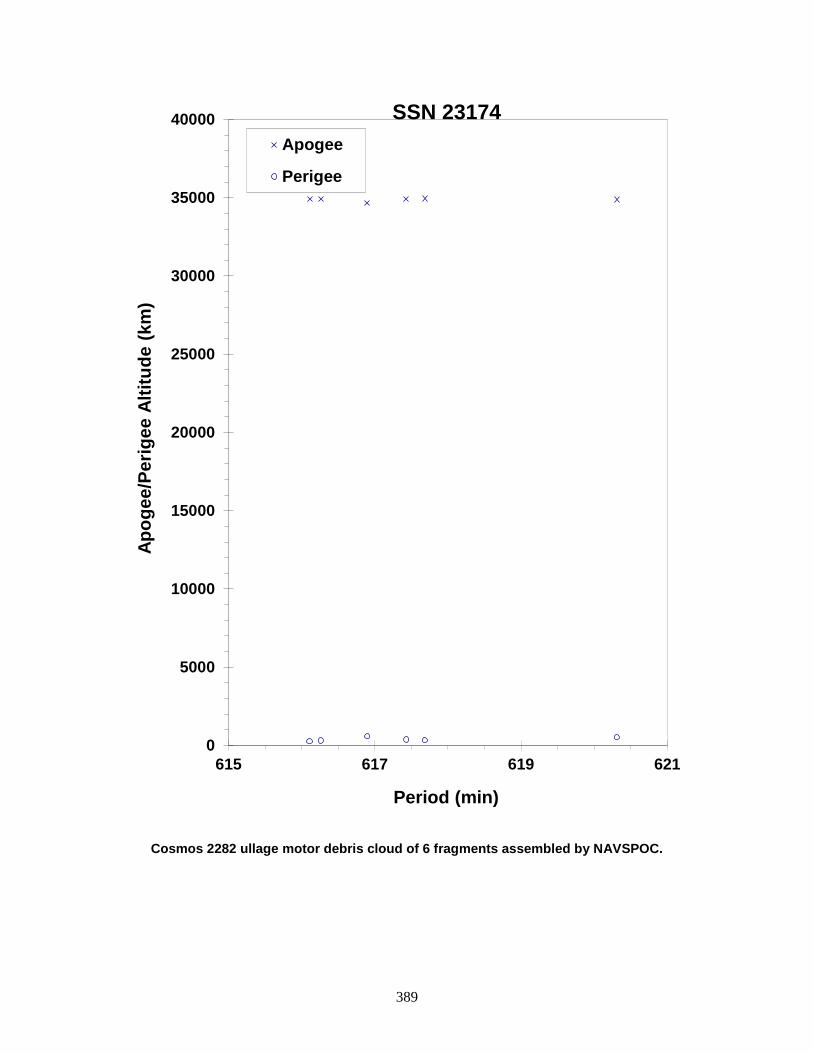
389
Cosmos 2282 ullage motor debris cloud of 6 fragments assembled by NAVSPOC.
0
5000
10000
15000
20000
25000
30000
35000
40000
615 617 619 621
Apog
ee/P
erig
ee A
ltitu
de (k
m)
Period (min)
Apogee
Perigee
SSN 23174
390
ELEKTRO ULLAGE MOTOR 1994-069E 23338 SATELLITE DATA TYPE: Mission Related Debris OWNER: CIS LAUNCH DATE: 31.60 Oct 1994 DRY MASS (KG): 55 MAIN BODY: Ellipsoid; 0.6 m diameter by 1 m length MAJOR APPENDAGES: None ATTITUDE CONTROL: None ENERGY SOURCES: On-board propellants EVENT DATA DATE: Prior to 0547 GMT, 11 May 1995 LOCATION: Unknown TIME: Unknown ASSESSED CAUSE: Propulsion ALTITUDE: Unknown PRE-EVENT ELEMENTS EPOCH: 95130.00087914 MEAN ANOMALY: 317.6470 RIGHT ASCENSION: 200.4799 MEAN MOTION: 11.93599702 INCLINATION: 46.9113 MEAN MOTION DOT/2: 0.99999999 ECCENTRICITY: 0.2007574 MEAN MOTION DOT DOT/6: 0.000034693 ARG. OF PERIGEE: 63.6124 BSTAR: 0.021116 DEBRIS CLOUD DATA MAXIMUM ∆P: Unknown MAXIMUM ∆I: Unknown COMMENTS Parent satellite was one of two small engine units that are routinely released after the first burn of the Proton fourth stage. The nature of these objects was identified by Dr. Boris V. Cherniatiev, Deputy Constructor for the Energiya NPO and Mr. Nicholas Johnson of Kaman Sciences, in October, 1992. The cause of this fragmentation appears to be related to the residual hypergolic propellants on board and failure of the membrane separating the fuel and oxidizer. NAVSPASUR observed up to 13 objects that were associated with this breakup on 11 May 95. This was the eleventh in a series of fragmentations of this object type. REFERENCE DOCUMENTS The Fragmentation of Proton Debris, D. J. Nauer, TBE Technical Report CS93-LKD-004, Teledyne Brown Engineering, Colorado Springs, 31 December 1992. Analysis of Fragmentations From December 1992 - February 1993, TBE Technical Report CS93-LKD-010, Teledyne Brown Engineering, Colorado Springs, 30 March 1993. Identification and Resolution of an Orbital Debris Problem with the Proton Launch Vehicle, B. V. Cherniatiev, et al, First European Conference on Space Debris, 5-7 April 1993.
History of Soviet/Russian Satellite Fragmentations-A Joint U.S.-Russian Investigation, N. L. Johnson et al, Kaman Sciences Corporation, October 1995.

391
Insufficient data to construct a Gabbard diagram.
392
COSMOS 2294-96 ULLAGE MOTOR 1994-076G 23402 SATELLITE DATA TYPE: Mission Related Debris OWNER: CIS LAUNCH DATE: 20 Nov 1994 DRY MASS (KG): 56.0 MAIN BODY: ellipsoid; 0.6 m diameter x 1 m length MAJOR APPENDAGES: none ATTITUDE CONTROL: none ENERGY SOURCES: on-board propellants EVENT DATA DATE: 7 June 2014 LOCATION: unknown TIME: unknown ASSESSED CAUSE: Propulsion ALTITUDE: unknown PRE-EVENT ELEMENTS EPOCH: 14156.48285780 MEAN ANOMALY: 3.5477 RIGHT ASCENSION: 76.9596 MEAN MOTION: 4.25680746 INCLINATION: 64.9844 MEAN MOTION DOT/2: 0.00004224 ECCENTRICITY: 0.5768591 MEAN MOTION DOT DOT/6: 0.00000 ARG. OF PERIGEE: 344.0988 BSTAR: 0.050698 DEBRIS CLOUD DATA MAXIMUM ∆P: unknown MAXIMUM ∆I: unknown COMMENTS This event was the 41st known fragmentation of Blok-DM ullage motors. The breakups are believed to be caused by residual propellants. Russian officials have been aware of the problem since 1992 and have made design changes, although the date of full implementation is unknown. Although at least 15 small debris were observed by the SSN, none have been officially cataloged. REFERENCE DOCUMENTS History of Soviet/Russian Satellite Fragmentations: A Joint U.S.-Russian Investigation. N.L. Johnson et al. Kaman Sciences Corporation, October 2005. “Flurry of Small Breakups in First Half of 2014”, The Orbital Debris Quarterly News, NASA JSC, July 2014. Available online at http://orbitaldebris.jsc.nasa.gov/newsletter/pdfs/ODQNv18i3.pdf.

393
Insufficient data to construct a Gabbard diagram.
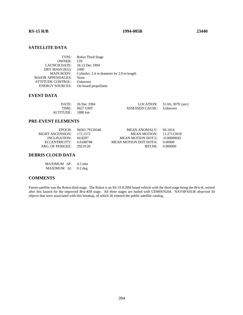
394
RS-15 R/B 1994-085B 23440 SATELLITE DATA TYPE: Rokot Third Stage OWNER: CIS LAUNCH DATE: 26.13 Dec 1994 DRY MASS (KG): 1000 MAIN BODY: Cylinder; 2.4 m diameter by 2.8 m length MAJOR APPENDAGES: None ATTITUDE CONTROL: Unknown ENERGY SOURCES: On-board propellants EVENT DATA DATE: 26 Dec 1994 LOCATION: 51.6S, 307E (asc) TIME: 0627 GMT ASSESSED CAUSE: Unknown ALTITUDE: 1880 km PRE-EVENT ELEMENTS EPOCH: 94361.79150546 MEAN ANOMALY: 66.1014 RIGHT ASCENSION: 172.1572 MEAN MOTION: 11.27113018 INCLINATION: 64.8297 MEAN MOTION DOT/2: -0.00000043 ECCENTRICITY: 0.0188748 MEAN MOTION DOT DOT/6: 0.00000 ARG. OF PERIGEE: 292.0126 BSTAR: 0.000000 DEBRIS CLOUD DATA MAXIMUM ∆P: 4.5 min MAXIMUM ∆I: 0.2 deg COMMENTS Parent satellite was the Rokot third stage. The Rokot is an SS-19 ICBM based vehicle with the third stage being the Briz-K, retired after this launch for the improved Briz-KM stage. All three stages are fueled with UDMH/N204. NAVSPASUR observed 34 objects that were associated with this breakup, of which 26 entered the public satellite catalog.
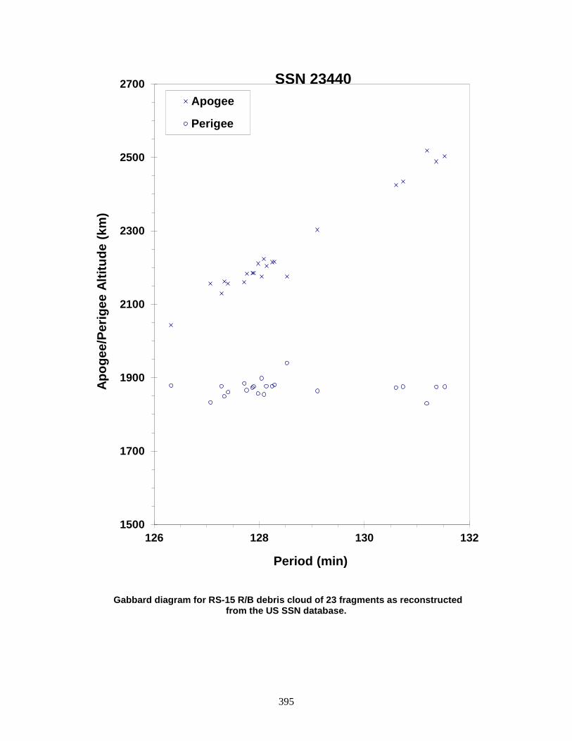
395
Gabbard diagram for RS-15 R/B debris cloud of 23 fragments as reconstructed from the US SSN database.
1500
1700
1900
2100
2300
2500
2700
126 128 130 132
Apog
ee/P
erig
ee A
ltitu
de (k
m)
Period (min)
Apogee
Perigee
SSN 23440
396
DMSP 5D-2 F13 (USA 109) 1995-015A 23533 SATELLITE DATA TYPE: Payload OWNER: US LAUNCH DATE: 24 Mar 1995 DRY MASS (KG): 767 MAIN BODY: cylinder; 1.0 m diameter x 3.6 m length MAJOR APPENDAGES: solar panel ATTITUDE CONTROL: three-axis ENERGY SOURCES: on-board propellants and chemical batteries EVENT DATA DATE: 3.736 Feb 2015 LOCATION: 40.8S, 7.5E TIME: 1740 GMT ASSESSED CAUSE: Battery ALTITUDE: 860.7 km PRE-EVENT ELEMENTS - unavailable EPOCH: MEAN ANOMALY: RIGHT ASCENSION: MEAN MOTION: INCLINATION: MEAN MOTION DOT/2: ECCENTRICITY: MEAN MOTION DOT DOT/6: ARG. OF PERIGEE: BSTAR: DEBRIS CLOUD DATA MAXIMUM ∆P: unknown min MAXIMUM ∆I: unknown deg COMMENTS This is the second known breakup of a Defense Meteorological Satellite Program (DMSP) Block 5D-2 spacecraft, the first being DMSP 5D-2 F11 (USA 73). USA 109 was active when the event occurred and supporting telemetry was available for the inquiry. Analysis indicates that the event was due to an explosion of one of the Ni-Cd batteries. REFERENCE DOCUMENT “Recent Breakup of a DMSP Satellite”, The Orbital Debris Quarterly News, NASA JSC, April 2015. Available online at https://orbitaldebris.jsc.nasa.gov/quarterly-news/pdfs/ODQNv19i2.pdf.

397
USA 109 debris cloud. Debris cataloged between 22 and 160 days after event.
398
COSMOS 2313 1995-028A 23596 SATELLITE DATA TYPE: Payload OWNER: CIS LAUNCH DATE: 8.20 Jun 1995 DRY MASS (KG): 3000 MAIN BODY: Cylinder; 1.3 m diameter by 17 m length MAJOR APPENDAGES: Solar arrays ATTITUDE CONTROL: Active, 3-axis ENERGY SOURCES: On-board propellants, explosive charge? EVENT DATA DATE: 26 June 1997 LOCATION: 44 N, 173 E (asc.) TIME: 0257 GMT ASSESSED CAUSE: Unknown ALTITUDE: 285 km PRE-EVENT ELEMENTS EPOCH: 97176.10173599 MEAN ANOMALY: 124.6445 RIGHT ASCENSION: 342.0749 MEAN MOTION: 16.02369895 INCLINATION: 65.0221 MEAN MOTION DOT/2: 0.00306537 ECCENTRICITY: 0.0084335 MEAN MOTION DOT DOT/6: 0.0000069339 ARG. OF PERIGEE: 234.6794 BSTAR: 0.00033322 DEBRIS CLOUD DATA MAXIMUM ∆P: Unknown MAXIMUM ∆I: Unknown COMMENTS Cosmos 2313 was the second spacecraft of its type to breakup since November 1987. Prior to the current event 17 spacecraft of this class (Cosmos 699) have experienced breakups in low Earth orbit. In the 1980's procedures were introduced to deplete remaining propellants at the end of mission, reducing orbital lifetime at the same time. Cosmos 2313 performed such a maneuver during 22-23 April 1997 and was close to reentry at the time of the event. Earlier spacecraft breakups resulted in up to 150 or more trackable debris. The cause of the event may well not be propellant related, but by reducing the orbital lifetime recent vehicles have decayed before the trigger mechanism could activate. At least 90 debris were detected after this event. REFERENCE DOCUMENT “Three Satellite Breakups During May-June”, The Orbital Debris Quarterly News, NASA JSC, July 1997, p. 2. Available online at https://orbitaldebris.jsc.nasa.gov/quarterly-news/pdfs/ODQNv2i3.pdf.
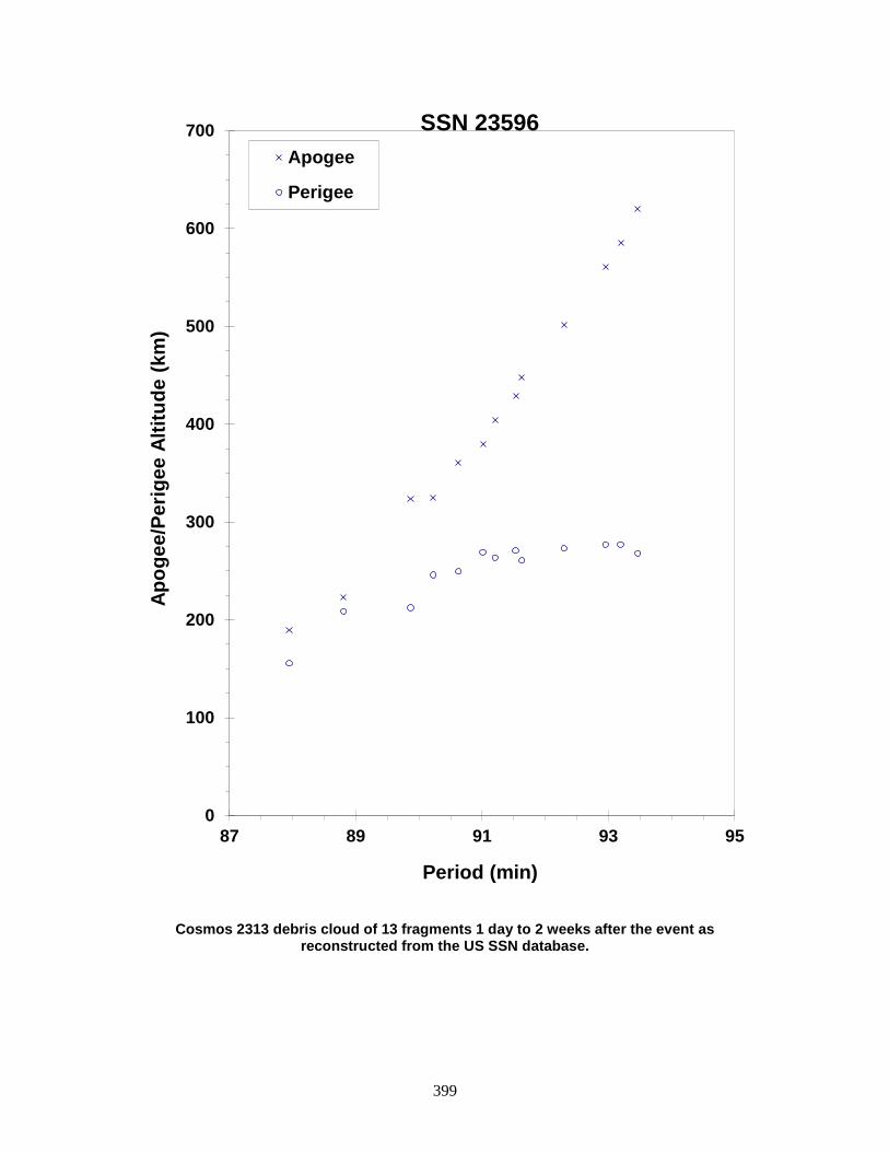
399
Cosmos 2313 debris cloud of 13 fragments 1 day to 2 weeks after the event as reconstructed from the US SSN database.
0
100
200
300
400
500
600
700
87 89 91 93 95
Apog
ee/P
erig
ee A
ltitu
de (k
m)
Period (min)
Apogee
Perigee
SSN 23596
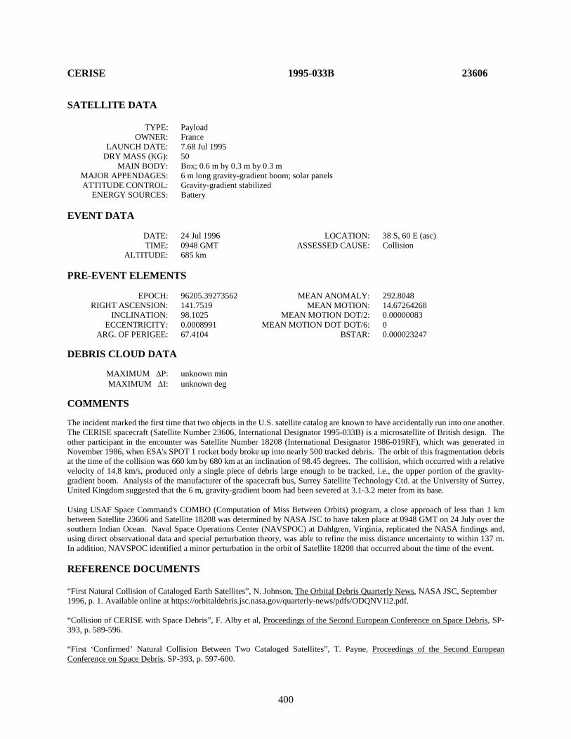
400
CERISE 1995-033B 23606 SATELLITE DATA TYPE: Payload OWNER: France LAUNCH DATE: 7.68 Jul 1995 DRY MASS (KG): 50 MAIN BODY: Box; 0.6 m by 0.3 m by 0.3 m MAJOR APPENDAGES: 6 m long gravity-gradient boom; solar panels ATTITUDE CONTROL: Gravity-gradient stabilized ENERGY SOURCES: Battery EVENT DATA DATE: 24 Jul 1996 LOCATION: 38 S, 60 E (asc) TIME: 0948 GMT ASSESSED CAUSE: Collision ALTITUDE: 685 km PRE-EVENT ELEMENTS EPOCH: 96205.39273562 MEAN ANOMALY: 292.8048 RIGHT ASCENSION: 141.7519 MEAN MOTION: 14.67264268 INCLINATION: 98.1025 MEAN MOTION DOT/2: 0.00000083 ECCENTRICITY: 0.0008991 MEAN MOTION DOT DOT/6: 0 ARG. OF PERIGEE: 67.4104 BSTAR: 0.000023247 DEBRIS CLOUD DATA MAXIMUM ∆P: unknown min MAXIMUM ∆I: unknown deg COMMENTS The incident marked the first time that two objects in the U.S. satellite catalog are known to have accidentally run into one another. The CERISE spacecraft (Satellite Number 23606, International Designator 1995-033B) is a microsatellite of British design. The other participant in the encounter was Satellite Number 18208 (International Designator 1986-019RF), which was generated in November 1986, when ESA's SPOT 1 rocket body broke up into nearly 500 tracked debris. The orbit of this fragmentation debris at the time of the collision was 660 km by 680 km at an inclination of 98.45 degrees. The collision, which occurred with a relative velocity of 14.8 km/s, produced only a single piece of debris large enough to be tracked, i.e., the upper portion of the gravity-gradient boom. Analysis of the manufacturer of the spacecraft bus, Surrey Satellite Technology Ctd. at the University of Surrey, United Kingdom suggested that the 6 m, gravity-gradient boom had been severed at 3.1-3.2 meter from its base. Using USAF Space Command's COMBO (Computation of Miss Between Orbits) program, a close approach of less than 1 km between Satellite 23606 and Satellite 18208 was determined by NASA JSC to have taken place at 0948 GMT on 24 July over the southern Indian Ocean. Naval Space Operations Center (NAVSPOC) at Dahlgren, Virginia, replicated the NASA findings and, using direct observational data and special perturbation theory, was able to refine the miss distance uncertainty to within 137 m. In addition, NAVSPOC identified a minor perturbation in the orbit of Satellite 18208 that occurred about the time of the event. REFERENCE DOCUMENTS “First Natural Collision of Cataloged Earth Satellites”, N. Johnson, The Orbital Debris Quarterly News, NASA JSC, September 1996, p. 1. Available online at https://orbitaldebris.jsc.nasa.gov/quarterly-news/pdfs/ODQNV1i2.pdf. “Collision of CERISE with Space Debris”, F. Alby et al, Proceedings of the Second European Conference on Space Debris, SP-393, p. 589-596. “First ‘Confirmed’ Natural Collision Between Two Cataloged Satellites”, T. Payne, Proceedings of the Second European Conference on Space Debris, SP-393, p. 597-600.
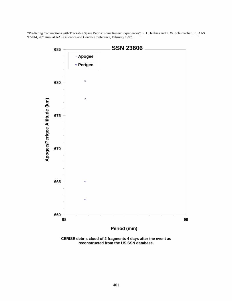
401
“Predicting Conjunctions with Trackable Space Debris: Some Recent Experiences”, E. L. Jenkins and P. W. Schumacher, Jr., AAS 97-014, 20th Annual AAS Guidance and Control Conference, February 1997.
CERISE debris cloud of 2 fragments 4 days after the event as
reconstructed from the US SSN database.
660
665
670
675
680
685
98 99
Apog
ee/P
erig
ee A
ltitu
de (k
m)
Period (min)
Apogee
Perigee
SSN 23606
402
COSMOS 2316-2318 ULLAGE MOTOR 1995-037K 23631 SATELLITE DATA TYPE: Proton Block DM SOZ Ullage Motor OWNER: CIS LAUNCH DATE: 24.66 Jul 1995 DRY MASS (KG): ~55 kg MAIN BODY: ~0.6 m by 0.6 m by 1.0 m MAJOR APPENDAGES: None ATTITUDE CONTROL: None ENERGY SOURCES: On-board propellants? EVENT DATA DATE: 21 Nov 2000 LOCATION: Unknown TIME: Unknown ASSESSED CAUSE: Propulsion ALTITUDE: Unknown PRE-EVENT ELEMENTS EPOCH: 00324.99357911 MEAN ANOMALY: 90.3648 RIGHT ASCENSION: 200.0539 MEAN MOTION: 4.50149006 INCLINATION: 64.4375 MEAN MOTION DOT/2: 0.00164632 ECCENTRICITY: 0.5787543 MEAN MOTION DOT DOT/6: 0.00000030156 ARG. OF PERIGEE: 213.7574 BSTAR: 0.00048999 DEBRIS CLOUD DATA MAXIMUM ∆P: Unknown MAXIMUM ∆I: Unknown COMMENTS This is the 4th breakup of 2000 and the 23rd breakup of a Proton SOZ motor (see Orbital Debris Quarterly Newsletter V, Issue 4, p. 2.) This object is associated with the 24 July 1995 launch (1995-037) of the Cosmos 2316-2318 satellites. These members of the GLONASS series are equivalent to GPS/Navstar satellites and reside in middle Earth orbit. This object was one of two pieces left in the transfer orbit and is assessed to be one of the SOZ ullage/orientation motor units. As of November 21, 2000, this object had been on orbit 5 years and 121 days. REFERENCE DOCUMENT “SOZ Ullage Motor Breakup”, The Orbital Debris Quarterly News, NASA JSC, January 2001. Available online at https://orbitaldebris.jsc.nasa.gov/quarterly-news/pdfs/odqnv6i1.pdf.

403
Insufficient data to construct a Gabbard diagram.

404
RADUGA 33 R/B 1996-010D 23797 SATELLITE DATA TYPE: Proton Blok DM Fourth Stage OWNER: CIS LAUNCH DATE: 19.36 Feb 1996 DRY MASS (KG): 3400 (?) MAIN BODY: Cylinder; 3.7 m diameter by 6.3 m length MAJOR APPENDAGES: None ATTITUDE CONTROL: Active, 3-axis ENERGY SOURCES: On-board propellants, pressurants, and batteries EVENT DATA DATE: 19 Feb 1996 LOCATION: 0.2 N, 88.8 E (dsc) TIME: 1459 GMT ASSESSED CAUSE: Propulsion ALTITUDE: 36511 km POST-EVENT ELEMENTS EPOCH: 96058.46760248 MEAN ANOMALY: 359.9314 RIGHT ASCENSION: 280.4138 MEAN MOTION: 2.23172282 INCLINATION: 48.7 MEAN MOTION DOT/2: 0.0002158 ECCENTRICITY: 0.7321111 MEAN MOTION DOT DOT/6: 0.0000 ARG. OF PERIGEE: 1.7779 BSTAR: 0.00068491 DEBRIS CLOUD DATA MAXIMUM ∆P: Unknown MAXIMUM ∆I: Unknown COMMENTS The first burn of this stage was successful and indicates that 23797 was in a transfer orbit. However, prior to the first pass through the NAVSPOC fence, 23797 fragmented. Twenty (20) pieces were observed during this first pass. During a subsequent pass, 196 pieces were observed that were associated with the upperstage. Stage apparently broke up after main engine restart for GEO apogee maneuver. REFERENCE DOCUMENT “Satellite Fragmentations in 1996”, N. Johnson, The Orbital Debris Quarterly News, NASA JSC, January 1997, p. 1. Available online at https://orbitaldebris.jsc.nasa.gov/quarterly-news/pdfs/ODQNv2i1.pdf.
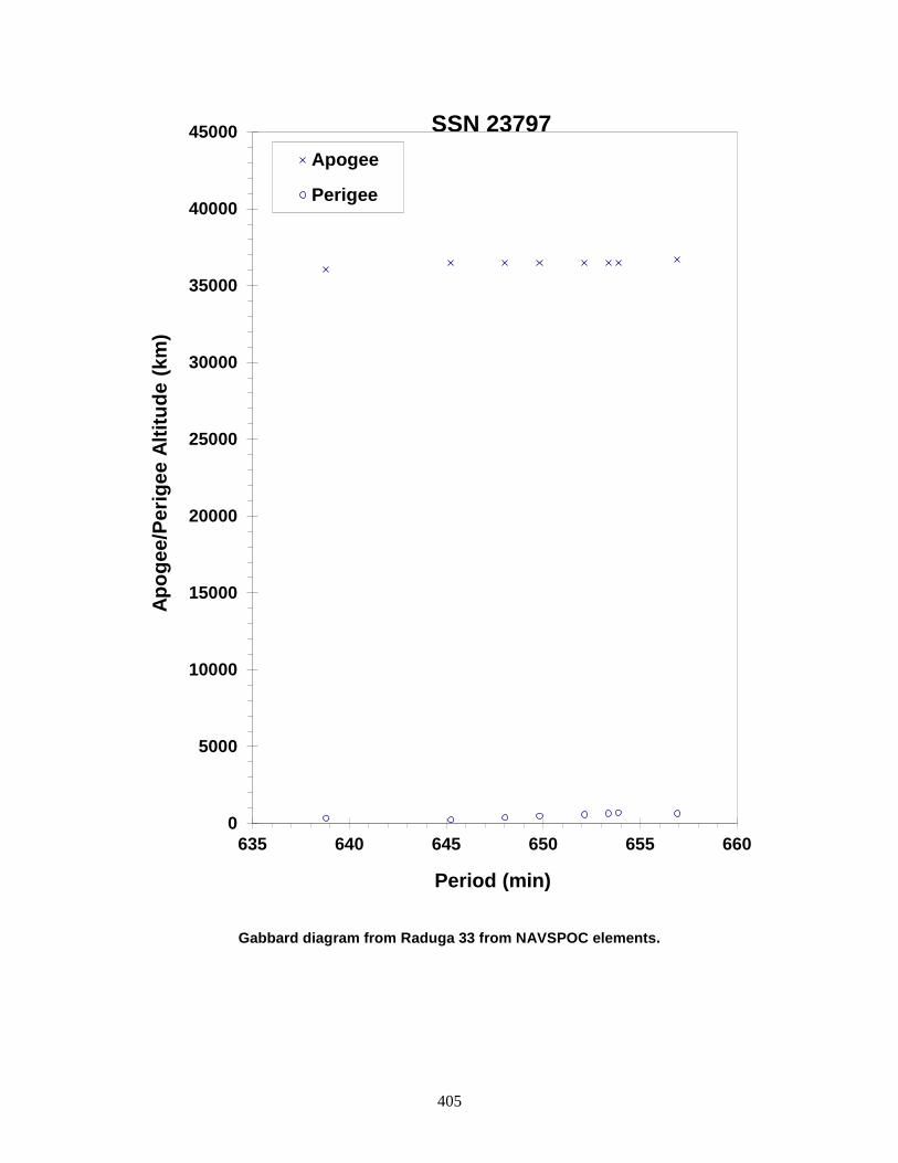
405
Gabbard diagram from Raduga 33 from NAVSPOC elements.
0
5000
10000
15000
20000
25000
30000
35000
40000
45000
635 640 645 650 655 660
Apog
ee/P
erig
ee A
ltitu
de (k
m)
Period (min)
Apogee
Perigee
SSN 23797

406
GORIZONT 32 ULLAGE MOTOR 1996-034F 23887 SATELLITE DATA TYPE: Mission Related Debris OWNER: CIS LAUNCH DATE: 25.09 May 1996 DRY MASS (KG): 55 MAIN BODY: Ellipsoid; 0.6 m diameter by 1 m length MAJOR APPENDAGES: None ATTITUDE CONTROL: Unknown ENERGY SOURCES: On-board Propellants EVENT DATA DATE: ~13 Dec 1999 LOCATION: Unknown TIME: Unknown ASSESSED CAUSE: Propulsion ALTITUDE: Unknown PRE-EVENT ELEMENTS EPOCH: 99347.02294368 MEAN ANOMALY: 314.8549 RIGHT ASCENSION: 194.3249 MEAN MOTION: 9.75630550 INCLINATION: 46.4558 MEAN MOTION DOT/2: 0.00969995 ECCENTRICITY: 0.2950283 MEAN MOTION DOT DOT/6: 0.0000015400 ARG. OF PERIGEE: 75.9037 BSTAR: 0.00055450 CATALOGED DEBRIS CLOUD DATA MAXIMUM ∆P: Unknown MAXIMUM ∆I: Unknown COMMENTS This is 21st breakup event for an object of this class, and the third in 1999. The breakups are believed to be caused by residual propellants. Russian officials have been aware of the problem since 1992 and have made design changes, although the date of full implementation is unknown. This is the most recently launched object to breakup (age = ~3.5 years). The environmental consequence of the breakup was short-lived; the object was in catastrophic decay from a geosynchronous transfer orbit. REFERENCE DOCUMENTS The Fragmentation of Proton Debris, D. J. Nauer, TBE Technical Report CS93-LKD-004, Teledyne Brown Engineering, Colorado Springs, 31 December 1992. Analysis of Fragmentations From December 1992 - February 1993, TBE Technical Report CS93-LKD-010, Teledyne Brown Engineering, Colorado Springs, 30 March 1993.
407
Insufficient data to construct a Gabbard diagram.
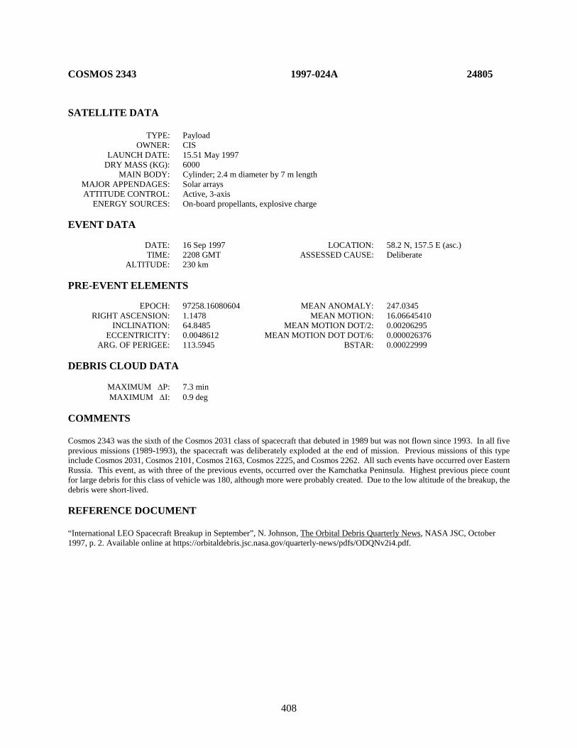
408
COSMOS 2343 1997-024A 24805 SATELLITE DATA TYPE: Payload OWNER: CIS LAUNCH DATE: 15.51 May 1997 DRY MASS (KG): 6000 MAIN BODY: Cylinder; 2.4 m diameter by 7 m length MAJOR APPENDAGES: Solar arrays ATTITUDE CONTROL: Active, 3-axis ENERGY SOURCES: On-board propellants, explosive charge EVENT DATA DATE: 16 Sep 1997 LOCATION: 58.2 N, 157.5 E (asc.) TIME: 2208 GMT ASSESSED CAUSE: Deliberate ALTITUDE: 230 km PRE-EVENT ELEMENTS EPOCH: 97258.16080604 MEAN ANOMALY: 247.0345 RIGHT ASCENSION: 1.1478 MEAN MOTION: 16.06645410 INCLINATION: 64.8485 MEAN MOTION DOT/2: 0.00206295 ECCENTRICITY: 0.0048612 MEAN MOTION DOT DOT/6: 0.000026376 ARG. OF PERIGEE: 113.5945 BSTAR: 0.00022999 DEBRIS CLOUD DATA MAXIMUM ∆P: 7.3 min MAXIMUM ∆I: 0.9 deg COMMENTS Cosmos 2343 was the sixth of the Cosmos 2031 class of spacecraft that debuted in 1989 but was not flown since 1993. In all five previous missions (1989-1993), the spacecraft was deliberately exploded at the end of mission. Previous missions of this type include Cosmos 2031, Cosmos 2101, Cosmos 2163, Cosmos 2225, and Cosmos 2262. All such events have occurred over Eastern Russia. This event, as with three of the previous events, occurred over the Kamchatka Peninsula. Highest previous piece count for large debris for this class of vehicle was 180, although more were probably created. Due to the low altitude of the breakup, the debris were short-lived. REFERENCE DOCUMENT “International LEO Spacecraft Breakup in September”, N. Johnson, The Orbital Debris Quarterly News, NASA JSC, October 1997, p. 2. Available online at https://orbitaldebris.jsc.nasa.gov/quarterly-news/pdfs/ODQNv2i4.pdf.

409
Cosmos 2343 debris cloud of 28 fragments as reconstructed from the US SSN database.
0
100
200
300
400
500
600
700
800
900
1000
88 90 92 94 96 98
Apog
ee/P
erig
ee A
ltitu
de (k
m)
Period (min)
Apogee
Perigee
SSN 24805
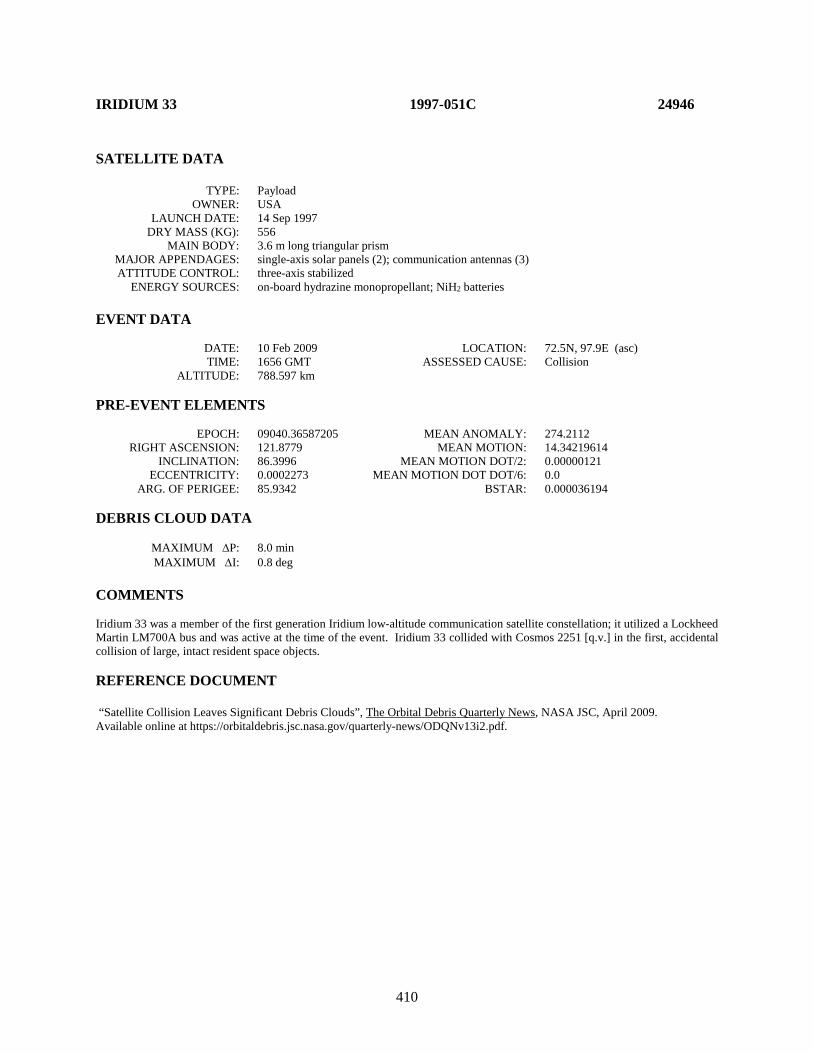
410
IRIDIUM 33 1997-051C 24946 SATELLITE DATA TYPE: Payload OWNER: USA LAUNCH DATE: 14 Sep 1997 DRY MASS (KG): 556 MAIN BODY: 3.6 m long triangular prism MAJOR APPENDAGES: single-axis solar panels (2); communication antennas (3) ATTITUDE CONTROL: three-axis stabilized ENERGY SOURCES: on-board hydrazine monopropellant; NiH2 batteries EVENT DATA DATE: 10 Feb 2009 LOCATION: 72.5N, 97.9E (asc) TIME: 1656 GMT ASSESSED CAUSE: Collision ALTITUDE: 788.597 km PRE-EVENT ELEMENTS EPOCH: 09040.36587205 MEAN ANOMALY: 274.2112 RIGHT ASCENSION: 121.8779 MEAN MOTION: 14.34219614 INCLINATION: 86.3996 MEAN MOTION DOT/2: 0.00000121 ECCENTRICITY: 0.0002273 MEAN MOTION DOT DOT/6: 0.0 ARG. OF PERIGEE: 85.9342 BSTAR: 0.000036194 DEBRIS CLOUD DATA MAXIMUM ∆P: 8.0 min MAXIMUM ∆I: 0.8 deg COMMENTS Iridium 33 was a member of the first generation Iridium low-altitude communication satellite constellation; it utilized a Lockheed Martin LM700A bus and was active at the time of the event. Iridium 33 collided with Cosmos 2251 [q.v.] in the first, accidental collision of large, intact resident space objects. REFERENCE DOCUMENT “Satellite Collision Leaves Significant Debris Clouds”, The Orbital Debris Quarterly News, NASA JSC, April 2009. Available online at https://orbitaldebris.jsc.nasa.gov/quarterly-news/ODQNv13i2.pdf.
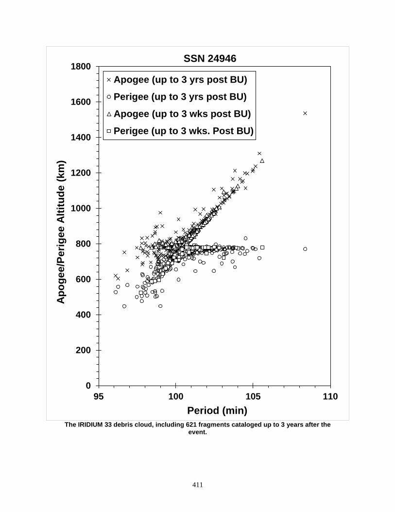
411
The IRIDIUM 33 debris cloud, including 621 fragments cataloged up to 3 years after the
event.
0
200
400
600
800
1000
1200
1400
1600
1800
95 100 105 110
Apog
ee/P
erig
ee A
ltitu
de (k
m)
Period (min)
SSN 24946
Apogee (up to 3 yrs post BU)
Perigee (up to 3 yrs post BU)
Apogee (up to 3 wks post BU)
Perigee (up to 3 wks. Post BU)
412
KUPON ULLAGE MOTOR 1997-070F 25054 SATELLITE DATA TYPE: Mission Related Debris OWNER: CIS LAUNCH DATE: 12.71 Nov 1997 DRY MASS (KG): 55 MAIN BODY: Ellipsoid; 0.6 m diameter by 1 m length MAJOR APPENDAGES: None ATTITUDE CONTROL: None ENERGY SOURCES: On-board propellant EVENT DATA DATE: 14 Feb 2007 LOCATION: Unknown TIME: Unknown ASSESSED CAUSE: Propulsion ALTITUDE: Unknown PRE-EVENT ELEMENTS EPOCH: 07044.95683864 MEAN ANOMALY: 35.6246 RIGHT ASCENSION: 14.2124 MEAN MOTION: 5.48131368 INCLINATION: 46.649 MEAN MOTION DOT/2: 0.00001445 ECCENTRICITY: 0.5113669 MEAN MOTION DOT DOT/6: 0.0 ARG. OF PERIGEE: 267.6957 BSTAR: 0.00013146 DEBRIS CLOUD DATA MAXIMUM ∆P: Unknown MAXIMUM ∆I: Unknown COMMENTS The object was in a decaying geosynchronous transfer orbit; this event marks the 36th known breakup of a Proton Blok DM SOZ ullage motor since 1984. By accident, an observer in Finland captured about 20 of the debris with two CCD cameras less than 24 hours after the event. The debris would have been too faint to be seen with the naked eye. An estimated 60 debris were detected by the US SSN. REFERENCE DOCUMENTS History of Soviet/Russian Satellite Fragmentations-A Joint U.S.-Russian Investigation, N. L. Johnson et al, Kaman Sciences Corporation, October 1995. “Four Satellite Breakups in February Add to Debris Population”, The Orbital Debris Quarterly News, NASA JSC, April 2007. Available online at https://orbitaldebris.jsc.nasa.gov/quarterly-news/pdfs/ODQNv11i2.pdf.

413
Insufficient data to construct a Gabbard diagram.

414
COSMOS 2347 1997-079A 25088 SATELLITE DATA TYPE: Payload OWNER: CIS LAUNCH DATE: 9.30 Dec 1997 DRY MASS (KG): 3000 MAIN BODY: 1.3 m diameter by 17 m length, plus solar arrays MAJOR APPENDAGES: Solar arrays ATTITUDE CONTROL: Active, 3-axis ENERGY SOURCES: On-board propellants, explosive charge? EVENT DATA DATE: 22 Nov 1999 LOCATION: 31.6N, 4.3E (dsc) TIME: 0440 GMT ASSESSED CAUSE: Unknown ALTITUDE: 370 km PRE-EVENT ELEMENTS EPOCH: 99325.85267585 MEAN ANOMALY: 85.1293 RIGHT ASCENSION: 332.8746 MEAN MOTION: 15.83563975 INCLINATION: 65.0115 MEAN MOTION DOT/2: 0.00295116 ECCENTRICITY: 0.0134056 MEAN MOTION DOT DOT/6: 0.000036131 ARG. OF PERIGEE: 273.4567 BSTAR: 0.00065869 DEBRIS CLOUD DATA MAXIMUM ∆P: 2.834 min MAXIMUM ∆I: 0.22 deg COMMENTS Cosmos 2347 was the 19th spacecraft of this type known to have experienced a major fragmentation. Such events were common prior to 1988, but only three breakups have occurred during the past 12 years: Cosmos 2347, Cosmos 2238 (1 Dec 1994), and Cosmos 2313 (26 June 1997). In this case Cosmos 2347 had performed a standard end-of-mission maneuver on 19 November 1999, a little more than 2 days before the breakup. Extensive analyses of these events have been conducted, although the cause is still unknown in the open literature. A second breakup of Cosmos 2347 was discovered on 10 December when the spacecraft’s orbit had decayed to 175 km by 250 km. Three dozen new debris were detected after the second event, but the very low altitude made it difficult to assess accurately the number of large debris. Prior spacecraft (especially Cosmos 1220, 1260, and 1306) also experienced multiple fragmentations. REFERENCE DOCUMENT “Satellite Breakups Increase in Last Quarter of 1999”, The Orbital Debris Quarterly News, NASA JSC, January 2000. Available online at https://orbitaldebris.jsc.nasa.gov/quarterly-news/pdfs/ODQNv5i1.pdf.
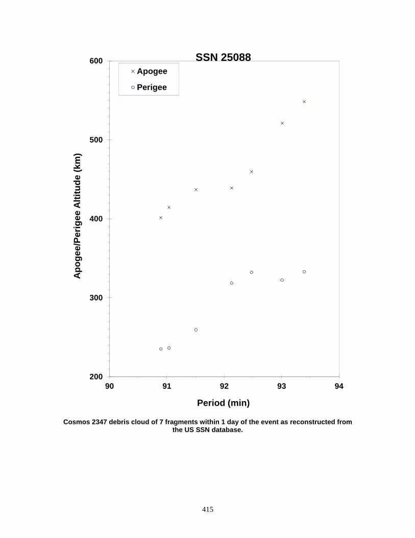
415
Cosmos 2347 debris cloud of 7 fragments within 1 day of the event as reconstructed from
the US SSN database.
200
300
400
500
600
90 91 92 93 94
Apog
ee/P
erig
ee A
ltitu
de (k
m)
Period (min)
Apogee
Perigee
SSN 25088

416
ASIASAT 3 R/B (2) 1997-086D 25129 SATELLITE DATA TYPE: Proton Blok DM Fourth Stage OWNER: CIS LAUNCH DATE: 24.97 Dec 1997 DRY MASS (KG): 3400 (?) MAIN BODY: Cylinder; 3.7 m diameter by 6.3 m length MAJOR APPENDAGES: None ATTITUDE CONTROL: Active, 3-axis ENERGY SOURCES: On-board propellants EVENT DATA DATE: 25 Dec 1997 LOCATION: 0.3 S, 91.2 E (dsc) TIME: 0550 GMT ASSESSED CAUSE: Propulsion ALTITUDE: 35995 km POST-EVENT ELEMENTS EPOCH: 97359.90803672 MEAN ANOMALY: 359.8589 RIGHT ASCENSION: 92.0594 MEAN MOTION: 2.26580509 INCLINATION: 51.4499 MEAN MOTION DOT/2: -0.00000507 ECCENTRICITY: 0.7304004 MEAN MOTION DOT DOT/6: 0 ARG. OF PERIGEE: 1.0181 BSTAR: 0 DEBRIS CLOUD DATA MAXIMUM ∆P: Unknown MAXIMUM ∆I: Unknown COMMENTS The commercial Asiasat 3 spacecraft was launched by a Proton launch vehicle at 2319 GMT, 24 December 1997. The fourth stage completed its first burn successfully about 0035 GMT, 25 December, placing the R/B-S/C combination into a GTO. When the vehicle reached its first apogee, the main engine was restarted but shutdown within 1 second, apparently due to a catastrophic failure. The US Space Surveillance Network detected less than 10 objects, and by 9 January only 1-2 were still being observed. The fragmentation is similar to the breakup of the Raduga 33 upper stage on 19 Feb 1996. In that case, nearly 200 debris were detected by the SSN. REFERENCE DOCUMENT “Recent Satellite Fragmentation Investigations”, N. Johnson, The Orbital Debris Quarterly News, January 1998, p. 3. Available online at https://orbitaldebris.jsc.nasa.gov/quarterly-news/pdfs/ODQNv3i1.pdf.

417
Insufficient data to construct a Gabbard diagram.
418
COMETS R/B 1998-011B 25176 SATELLITE DATA TYPE: H-II Second Stage OWNER: Japan LAUNCH DATE: 21.33 Feb 1998 DRY MASS (KG): 3000 MAIN BODY: Spheroid + cylinder + cone; 4 m diameter by 10.1 m length MAJOR APPENDAGES: None ATTITUDE CONTROL: Active, 3-axis ENERGY SOURCES: On-board propellants EVENT DATA DATE: 21 Feb 1998 LOCATION: Unknown TIME: Unknown ASSESSED CAUSE: Propulsion ALTITUDE: Unknown POST-EVENT ELEMENTS EPOCH: 98054.59975400 MEAN ANOMALY: 162.0601 RIGHT ASCENSION: 294.3031 MEAN MOTION: 13.51967368 INCLINATION: 30.0458 MEAN MOTION DOT/2: 0.0002873 ECCENTRICITY: 0.1097485 MEAN MOTION DOT DOT/6: -0.000003104 ARG. OF PERIGEE: 194.5714 BSTAR: 0.00029603 DEBRIS CLOUD DATA MAXIMUM ∆P: Unknown MAXIMUM ∆I: Unknown COMMENTS According to a NASDA report, a welding failure caused the LE-5A engine shutdown that stranded the Japanese COMETS satellite (1998-011A) in an elliptical orbit. The failure occurred 47 seconds into an apogee-raising maneuver. The report determined from telemetry data that hot combustion gases managed to penetrated special welding, called brazing, between nickel alloy cooling tubes in the lowest part of the combustion chamber near the top of the engine's nozzle skirt. Burning through the tubes, combustion gases quickly caused a fire, which triggered the engine shutdown. The report concludes the accident was caused by a manufacturing flaw and not a fundamental design problem. At least three dozen debris were detected by optical sensors in Hawaii. REFERENCE DOCUMENTS Kallender, P., “LE-5A Shutdown Blamed on Welding.” Space News, 23-29 March 1998, p. 6. “The Upper Stage Breakups in One Week Top February Debris Activity”, The Orbital Debris Quarterly News, NASA JSC, April 1998, p. 1. Available online at https://orbitaldebris.jsc.nasa.gov/quarterly-news/pdfs/ODQNv3i2.pdf.

419
Insufficient data to construct a Gabbard diagram.
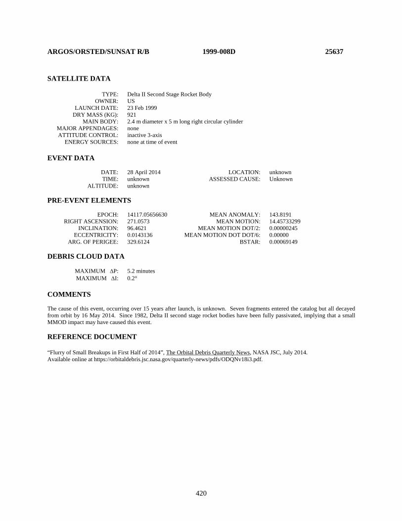
420
ARGOS/ORSTED/SUNSAT R/B 1999-008D 25637 SATELLITE DATA TYPE: Delta II Second Stage Rocket Body OWNER: US LAUNCH DATE: 23 Feb 1999 DRY MASS (KG): 921 MAIN BODY: 2.4 m diameter x 5 m long right circular cylinder MAJOR APPENDAGES: none ATTITUDE CONTROL: inactive 3-axis ENERGY SOURCES: none at time of event EVENT DATA DATE: 28 April 2014 LOCATION: unknown TIME: unknown ASSESSED CAUSE: Unknown ALTITUDE: unknown PRE-EVENT ELEMENTS EPOCH: 14117.05656630 MEAN ANOMALY: 143.8191 RIGHT ASCENSION: 271.0573 MEAN MOTION: 14.45733299 INCLINATION: 96.4621 MEAN MOTION DOT/2: 0.00000245 ECCENTRICITY: 0.0143136 MEAN MOTION DOT DOT/6: 0.00000 ARG. OF PERIGEE: 329.6124 BSTAR: 0.00069149 DEBRIS CLOUD DATA MAXIMUM ∆P: 5.2 minutes MAXIMUM ∆I: 0.2° COMMENTS The cause of this event, occurring over 15 years after launch, is unknown. Seven fragments entered the catalog but all decayed from orbit by 16 May 2014. Since 1982, Delta II second stage rocket bodies have been fully passivated, implying that a small MMOD impact may have caused this event. REFERENCE DOCUMENT “Flurry of Small Breakups in First Half of 2014”, The Orbital Debris Quarterly News, NASA JSC, July 2014. Available online at https://orbitaldebris.jsc.nasa.gov/quarterly-news/pdfs/ODQNv18i3.pdf.
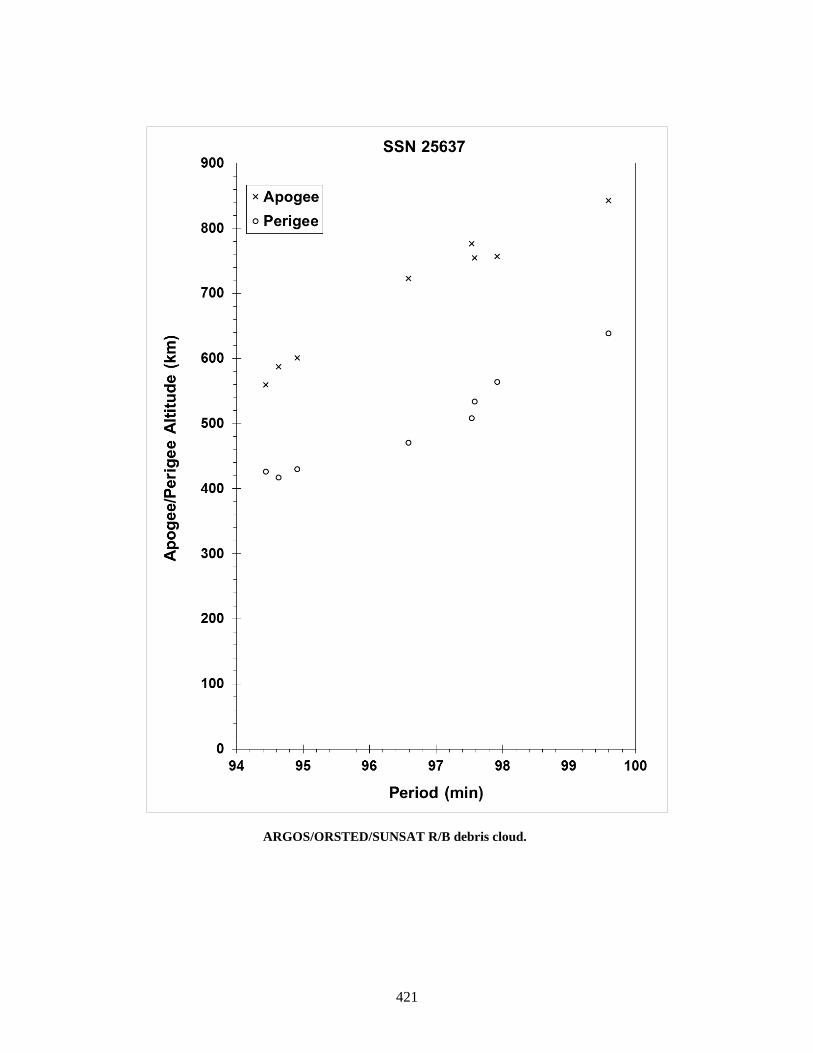
421
ARGOS/ORSTED/SUNSAT R/B debris cloud.

422
FENGYUN 1C 1999-025A 25730 SATELLITE DATA TYPE: Payload OWNER: PRC LAUNCH DATE: 10.06 May 1999 DRY MASS (KG): 950 MAIN BODY: Box; 1.5 m by 1.5 m by 1.5 m MAJOR APPENDAGES: Solar Panels, 1.5 m by 4 m ATTITUDE CONTROL: Active, 3-axis ENERGY SOURCES: On-board propellants EVENT DATA DATE: 11 Jan 2007 LOCATION: 35N, 100E (asc) TIME: 2226 GMT ASSESSED CAUSE: Deliberate (HVI) ALTITUDE: 860 km PRE-EVENT ELEMENTS EPOCH: 07011.90621003 MEAN ANOMALY: 94.0215 RIGHT ASCENSION: 1.7411 MEAN MOTION: 14.11820274 INCLINATION: 98.6464 MEAN MOTION DOT/2: 0.00000180 ECCENTRICITY: 0.0013513 MEAN MOTION DOT DOT/6: 0.0 ARG. OF PERIGEE: 266.0357 BSTAR: 0.00012153 DEBRIS CLOUD DATA MAXIMUM ∆P: 33.4 min MAXIMUM ∆I: 5.0 deg COMMENTS The debris cloud created by this anti-satellite test represents the worst contamination of low Earth orbit in history. More than half the identified debris were thrown into orbits exceeding a mean altitude of 850 km, meaning that much of the 10 cm and larger debris will be in orbit for decades or centuries. REFERENCE DOCUMENT “Chinese Anti-satellite Test Creates Most Severe Orbital Debris Cloud in History”, The Orbital Debris Quarterly News, NASA JSC, April 2007. Available online at https://orbitaldebris.jsc.nasa.gov/quarterly-news/pdfs/ODQNv11i2.pdf.
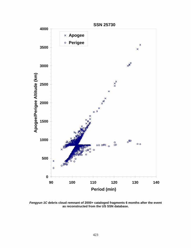
423
Fengyun 1C debris cloud remnant of 2000+ cataloged fragments 6 months after the event as reconstructed from the US SSN database.
0
500
1000
1500
2000
2500
3000
3500
4000
90 100 110 120 130 140
Period (min)
Apo
gee/
Perig
ee A
ltitu
de (k
m)
Apogee Perigee
SSN 25730
424
CBERS 1 1999-057A 25940 SATELLITE DATA TYPE: Payload OWNER: PRC/Brazil LAUNCH DATE: 14.14 Oct 1999 DRY MASS (KG): 1450 MAIN BODY: Box: 1.8 m by 2.0 m by 2.2 m MAJOR APPENDAGES: 6.3 m x 2.6 m Solar Panels ATTITUDE CONTROL: None at time of event ENERGY SOURCES: On-board propellant? EVENT DATA DATE: 18 Feb 2007 LOCATION: 35N, 128E (asc) TIME: 1107 GMT ASSESSED CAUSE: Unknown ALTITUDE: 780 km PRE-EVENT ELEMENTS EPOCH: 07049.17726620 MEAN ANOMALY: 250.9413 RIGHT ASCENSION: 88.9135 MEAN MOTION: 14.34483847 INCLINATION: 98.2175 MEAN MOTION DOT/2: -0.00000185 ECCENTRICITY: 0.0007520 MEAN MOTION DOT DOT/6: 0.0 ARG. OF PERIGEE: 109.2997 BSTAR: -0.000051172 DEBRIS CLOUD DATA MAXIMUM ∆P: 3.4 min MAXIMUM ∆I: 0.3 deg COMMENTS The spacecraft exceeded its expected lifetime and had been moved to a retirement orbit in August 2003. It is unclear whether or not it was entirely passivated. The rocket body associated with this payload (1999-057C, 25942) experienced an unrelated, but significant fragmentation six months after launch. REFERENCE DOCUMENT “Four Satellite Breakups in February Add to Debris Population”, The Orbital Debris Quarterly News, NASA JSC, April 2007. Available online at https://orbitaldebris.jsc.nasa.gov/quarterly-news/pdfs/ODQNv11i2.pdf.

425
CBERS 1 debris cloud of 16 cataloged fragments 2 weeks after the event as
reconstructed from the US SSN database.
500
550
600
650
700
750
800
850
900
950
1000
96 97 98 99 100 101 102
Period (min)
Apo
gee/
Perig
ee A
ltitu
de (k
m)
Apogee Perigee
SSN 25940

426
CBERS-1/SACI-1 R/B 1999-057C 25942 SATELLITE DATA TYPE: Long March 4 third stage OWNER: PRC LAUNCH DATE: 14.14 Oct 1999 DRY MASS (KG): 1000 MAIN BODY: Cylinder nozzle; 2.9 m diameter by ~5 m length MAJOR APPENDAGES: None ATTITUDE CONTROL: None ENERGY SOURCES: On-board propellants EVENT DATA DATE: 11 Mar 2000 LOCATION: 51.2S, 311.5W TIME: 1304 GMT ASSESSED CAUSE: Propulsion ALTITUDE: 741 km PRE-EVENT ELEMENTS EPOCH: 00070.18630445 MEAN ANOMALY: 46.4837 RIGHT ASCENSION: 146.5592 MEAN MOTION: 14.46869143 INCLINATION: 98.5376 MEAN MOTION DOT/2: 0.00001547 ECCENTRICITY: 0.0012358 MEAN MOTION DOT DOT/6: 0.0 ARG. OF PERIGEE: 313.5308 BSTAR: 0.00043864 DEBRIS CLOUD DATA MAXIMUM ∆P: 10.985 min MAXIMUM ∆I: 0.99 deg COMMENTS This is the second Long March 4 to breakup in only four missions. The first breakup (flight 2) occurred on 4 Oct 1990, 1 month after launch. Long March 4 missions did not resume until 1999, when two more were flown. This breakup involved the second 1999 mission (flight 4) and occurred 5 months after launch. This event has created more trackable debris than the 1990 breakup, with more than 300 pieces tracked by the SSN. Chinese officials were aware of the international concern following the 1990 breakup and had pledged to adopt countermeasures before the 1999 missions. Passivation of this vehicle was attempted. REFERENCE DOCUMENT “Analyzing the Cause of LM-4 (A)’s Upper Stage’s Disintegration and the Countermeasures”, W. X. Zang and S. Y. Liao, 5th International Conference of Pacific Basin Societies, 6-9 Jun 1993, Shanghai.

427
CBERS-1 / SACI-1 long March 4 third stage debris cloud of 280 fragments within 1 day of the event as reconstructed from the US SSN database.
200
400
600
800
1000
1200
1400
1600
1800
2000
94 96 98 100 102 104 106 108 110 112
Apog
ee/P
erig
ee A
ltitu
de (k
m)
Period (min)
Apogee
Perigee
SSN 25942

428
COSMOS 2367 1999-072A 26040 SATELLITE DATA TYPE: Payload OWNER: CIS LAUNCH DATE: 26.33 Dec 1999 DRY MASS (KG): ~3000 MAIN BODY: Cylinder; 1.3 m diameter by 17 m length, plus solar arrays MAJOR APPENDAGES: Solar Arrays ATTITUDE CONTROL: Active 3-axis ENERGY SOURCES: On-board propellant, explosive charge EVENT DATA DATE: 21 Nov 2001 LOCATION: 38.3 S, 342.3 E (dsc) TIME: 1414Z ASSESSED CAUSE: Unknown ALTITUDE: 410 km PRE-EVENT ELEMENTS EPOCH: 03325.57054648 MEAN ANOMALY: 199.8631 RIGHT ASCENSION: 55.0233 MEAN MOTION: 15.51939724 INCLINATION: 65.0021 MEAN MOTION DOT/2: 0.00131711 ECCENTRICITY: 0.0008788 MEAN MOTION DOT DOT/6: 0.0 ARG. OF PERIGEE: 257.3641 BSTAR: 0.0021441 DEBRIS CLOUD DATA MAXIMUM ∆P: 10.62 min* MAXIMUM ∆I: 1.28 deg* * Based on uncataloged debris data COMMENTS Cosmos 2367 was the 20th spacecraft of this type (Cosmos 699 class) known to have experienced a major fragmentation. The previous spacecraft in this series was Cosmos 2347, which experienced two fragmentations, one each in Nov and Dec of 1999. Cosmos 2367 was still in its operational orbit at the time of the event. Over 100 pieces were detected by the SSN 1 week after the breakup. Based upon other observations, the actual number of pieces probably exceeded 300. Although some debris were thrown into orbits with apogees above 1000 km, in general the debris were short-lived. REFERENCE DOCUMENT “Two Major Satellite Breakups Near End of 2001”, The Orbital Debris Quarterly News, NASA JSC, January 2002. Available online at https://orbitaldebris.jsc.nasa.gov/quarterly-news/pdfs/ODQNv7i1.pdf.
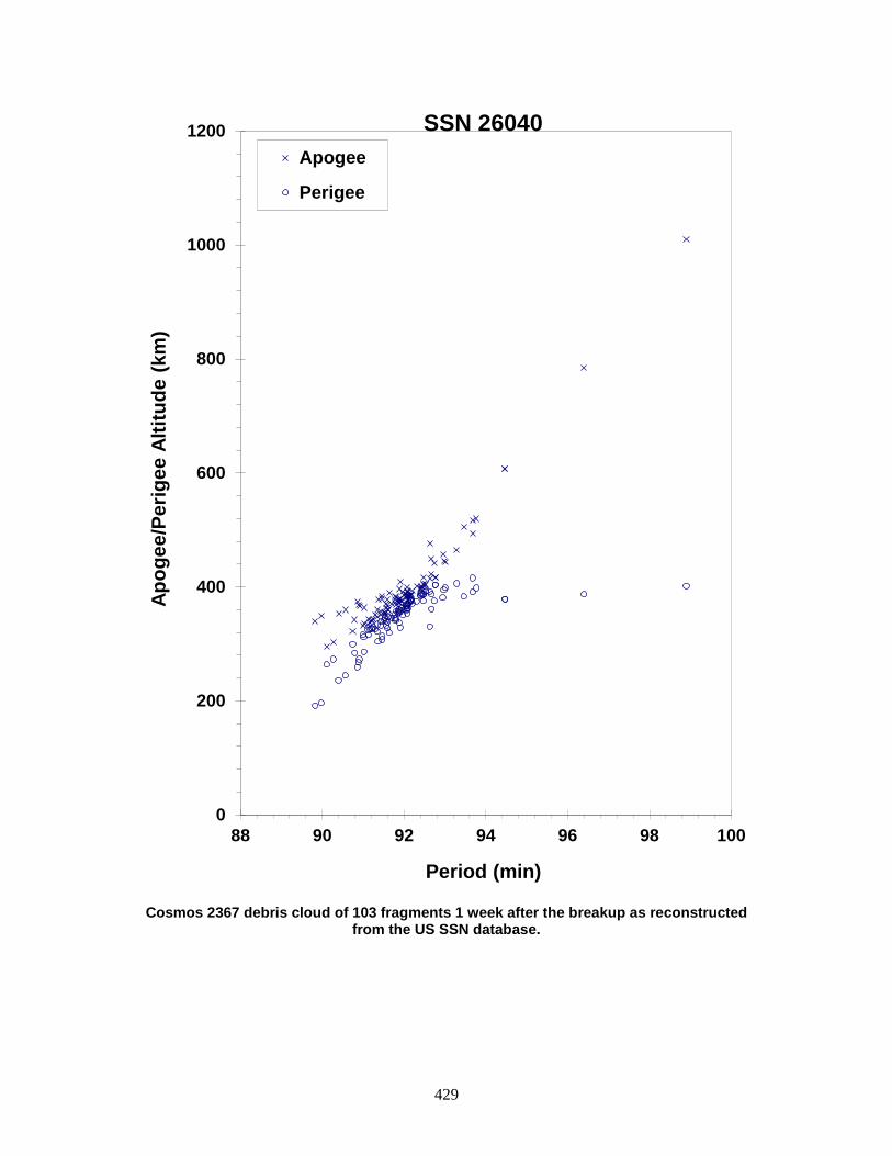
429
Cosmos 2367 debris cloud of 103 fragments 1 week after the breakup as reconstructed
from the US SSN database.
0
200
400
600
800
1000
1200
88 90 92 94 96 98 100
Apog
ee/P
erig
ee A
ltitu
de (k
m)
Period (min)
Apogee
Perigee
SSN 26040
430
COSMOS 2371 ULLAGE MOTOR 2000-036E 26398 SATELLITE DATA TYPE: Mission Related Debris OWNER: CIS LAUNCH DATE: 4.99 Jul 2000 DRY MASS (KG): 55 MAIN BODY: Ellipsoid; 0.6 m diameter by 1 m length MAJOR APPENDAGES: None ATTITUDE CONTROL: None ENERGY SOURCES: On-board propellant EVENT DATA DATE: ~1 Sep 2006 LOCATION: Unknown TIME: Unknown ASSESSED CAUSE: Propulsion ALTITUDE: Unknown PRE-EVENT ELEMENTS EPOCH: 06244.59746638 MEAN ANOMALY: 38.1280 RIGHT ASCENSION: 18.3906 MEAN MOTION: 3.86574836 INCLINATION: 46.8834 MEAN MOTION DOT/2: 0.00005467 ECCENTRICITY: 0.6151900 MEAN MOTION DOT DOT/6: 0.0 ARG. OF PERIGEE: 248.4110 BSTAR: 0.00034737 DEBRIS CLOUD DATA MAXIMUM ∆P: 98.8 min MAXIMUM ∆I: 0.2 deg COMMENTS The object was in a decaying geosynchronous transfer orbit; this event marks the 35th known breakup of a Proton Blok DM SOZ ullage motor since 1984. Only a handful of debris was detected from this event. REFERENCE DOCUMENTS History of Soviet/Russian Satellite Fragmentations-A Joint U.S.-Russian Investigation, N. L. Johnson et al, Kaman Sciences Corporation, October 1995. “Three More Satellites Involved in Fragmentations”, The Orbital Debris Quarterly News, NASA JSC, October 2006. Available online at https://orbitaldebris.jsc.nasa.gov/quarterly-news/pdfs/ODQNv10i4.pdf.
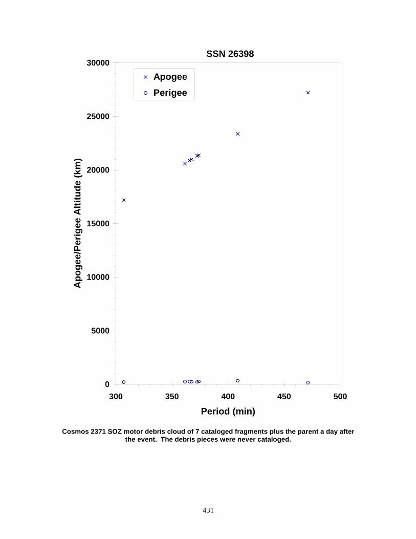
431
Cosmos 2371 SOZ motor debris cloud of 7 cataloged fragments plus the parent a day after
the event. The debris pieces were never cataloged.
0
5000
10000
15000
20000
25000
30000
300 350 400 450 500
Period (min)
Apo
gee/
Perig
ee A
ltitu
de (k
m)
Apogee Perigee
SSN 26398
432
NOAA 16 2000-055A 26536 SATELLITE DATA TYPE: Payload OWNER: US LAUNCH DATE: 21 Sep 2000 DRY MASS (KG): 1475 MAIN BODY: box; 1.88 m x 1.88 m x 4.2 m long MAJOR APPENDAGES: solar panel ATTITUDE CONTROL: none at time of event ENERGY SOURCES: on-board propellants and batteries EVENT DATA DATE: 25 Nov 2015 LOCATION: 77.5 N, 48.8 E (dsc) TIME: 0950 GMT ASSESSED CAUSE: Battery ALTITUDE: 855 km PRE-EVENT ELEMENTS EPOCH: 15329.31881564 MEAN ANOMALY: 226.6499 RIGHT ASCENSION: 34.9954 MEAN MOTION: 14.13117297 INCLINATION: 98.9249 MEAN MOTION DOT/2: 0.00000058 ECCENTRICITY: 0.0011308 MEAN MOTION DOT DOT/6: 0.00000 ARG. OF PERIGEE: 133.5614 BSTAR: 0.00054879 DEBRIS CLOUD DATA MAXIMUM ∆P: TBD min MAXIMUM ∆I: TBD deg COMMENTS This event was the second known breakup of a NOAA-series spacecraft, the other being NOAA-8. NOAA-16 performed its nominal mission until placed in backup status in 2005. An on-board anomaly ended communication on 6 June 2014 and the spacecraft was decommissioned on 9 June 2014. The event is assessed as likely being a battery explosion. REFERENCE DOCUMENTS “Recent NOAA_16 Satellite Breakup”, The Orbital Debris Quarterly News, NASA JSC, April 2016. Available online at http://orbitaldebris.jsc.nasa.gov/newsletter/pdfs/ODQNv20i1-2.pdf.
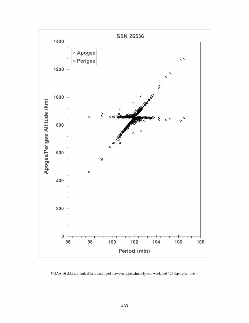
433
NOAA 16 debris cloud; debris cataloged between approximately one week and 123 days after event.

434
TES R/B 2001-049D 26960 SATELLITE DATA TYPE: PSLV Final Stage OWNER: India LAUNCH DATE: 22.20 Oct 2001 DRY MASS (KG): ~900 MAIN BODY: Cylinder; 2.8 m diameter by 2.6 m length MAJOR APPENDAGES: None ATTITUDE CONTROL: None ENERGY SOURCES: On-board hypergolic propellants EVENT DATA DATE: 19 Dec 2001 LOCATION: 25 S, 340 E (asc) TIME: ~1140Z ASSESSED CAUSE: Propulsion ALTITUDE: 670 km PRE-EVENT ELEMENTS EPOCH: 01352.90695581 MEAN ANOMALY: 316.4909 RIGHT ASCENSION: 65.6004 MEAN MOTION: 14.85657962 INCLINATION: 97.9010 MEAN MOTION DOT/2: -0.00000443 ECCENTRICITY: 0.0088752 MEAN MOTION DOT DOT/6: 0.0 ARG. OF PERIGEE: 44.3375 BSTAR: -0.000041058 DEBRIS CLOUD DATA MAXIMUM ∆P: 9.86 min* MAXIMUM ∆I: 3.06 deg* * Based on uncataloged debris data COMMENTS This is the first known breakup associated with the Polar Satellite Launch Vehicle (PSLV) fourth stage. While 332 fragments were initially detected by the SSN, 326 debris were cataloged. The vehicle employed hypergolic propellants that were not passivated after payload delivery. Some of the debris could remain in orbit for several years or longer. REFERENCE DOCUMENT “Two Major Satellite Breakups Near End of 2001”, The Orbital Debris Quarterly News, NASA JSC, January 2002. Available online at https://orbitaldebris.jsc.nasa.gov/quarterly-news/pdfs/ODQNv7i1.pdf.
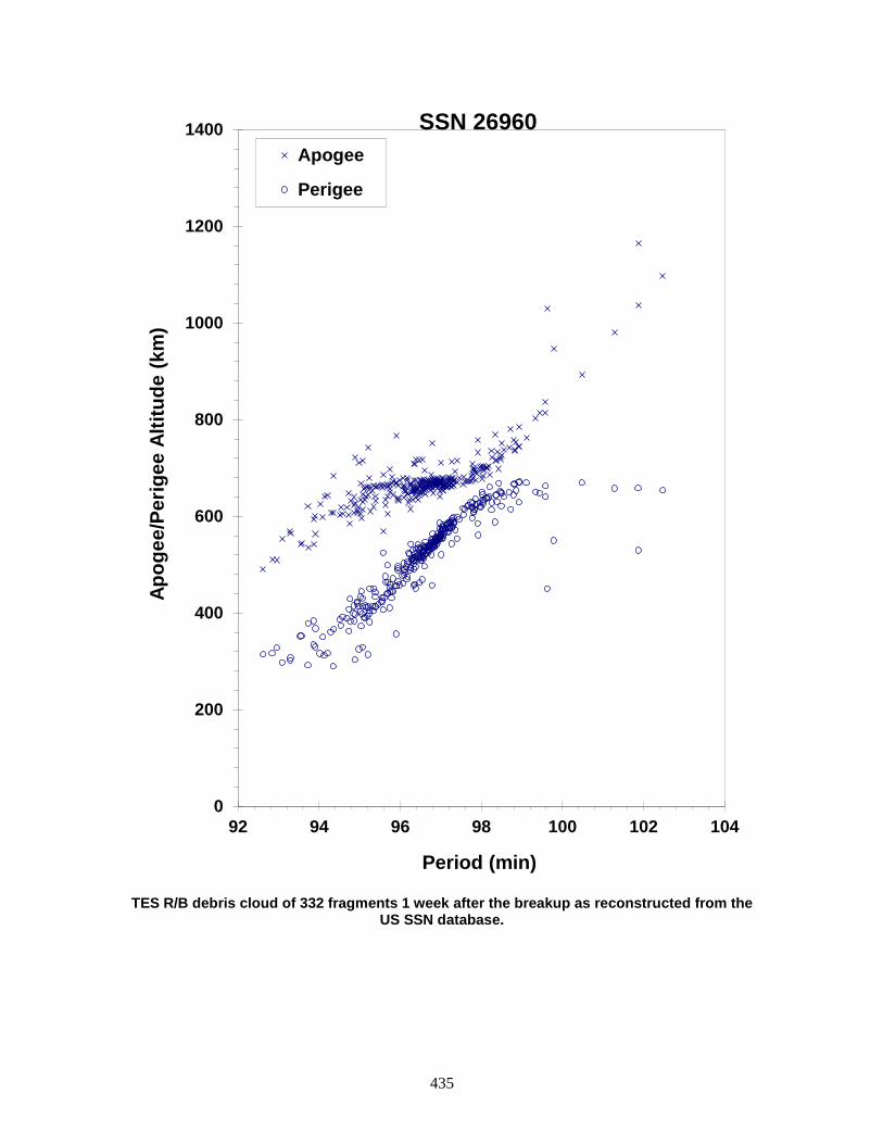
435
TES R/B debris cloud of 332 fragments 1 week after the breakup as reconstructed from the
US SSN database.
0
200
400
600
800
1000
1200
1400
92 94 96 98 100 102 104
Apog
ee/P
erig
ee A
ltitu
de (k
m)
Period (min)
Apogee
Perigee
SSN 26960

436
COSMOS 2383 2001-057A 27053 SATELLITE DATA TYPE: Payload OWNER: CIS LAUNCH DATE: 21.17 Dec 2001 DRY MASS (KG): 3000 MAIN BODY: Cylinder; 1.3 m diameter by 17 m length, plus solar arrays MAJOR APPENDAGES: Solar Arrays ATTITUDE CONTROL: Active 3-axis ENERGY SOURCES: On-board propellant; explosive charge EVENT DATA DATE: 28 Feb 2004 LOCATION: 26S, 100E (dsc) TIME: ~1930 GMT ASSESSED CAUSE: Unknown ALTITUDE: 265 km PRE-EVENT ELEMENTS EPOCH: 04059.20843210 MEAN ANOMALY: 95.7196 RIGHT ASCENSION: 358.8049 MEAN MOTION: 15.87352021 INCLINATION: 64.9763 MEAN MOTION DOT/2: 0.00416036 ECCENTRICITY: 0.0131275 MEAN MOTION DOT DOT/6: 0.000069430 ARG. OF PERIGEE: 262.9022 BSTAR: 0.00074756 DEBRIS CLOUD DATA MAXIMUM ∆P: 3.4 min MAXIMUM ∆I: 0.3 deg COMMENTS Cosmos 2383 was the 21st spacecraft of this type (Cosmos 699 class) known to have experienced a major fragmentation. The previous spacecraft in this series was Cosmos 2367, which experienced a fragmentation at an altitude just above the International Space Station in 2001. This event also produced debris crossing the ISS orbit altitude. Approximately 50 debris were detected by the US SSN. Fortunately, all the cataloged debris from this fragmentation were short-lived. Of the 48 spacecraft of this type, 21 have experienced fragmentation events. REFERENCE DOCUMENT “Fragmentation of Cosmos 2383”, The Orbital Debris Quarterly News, NASA JSC, April 2004. Available online at https://orbitaldebris.jsc.nasa.gov/quarterly-news/pdfs/ODQNv8i2.pdf.
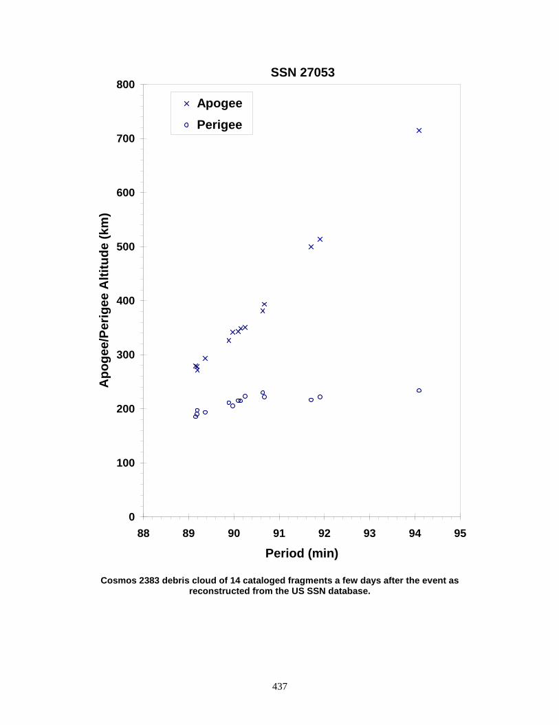
437
Cosmos 2383 debris cloud of 14 cataloged fragments a few days after the event as
reconstructed from the US SSN database.
0
100
200
300
400
500
600
700
800
88 89 90 91 92 93 94 95
Period (min)
Apo
gee/
Perig
ee A
ltitu
de (k
m)
Apogee Perigee
SSN 27053

438
COSMOS 2392 ULLAGE MOTOR 2002-037E 27474 SATELLITE DATA TYPE: Mission Related Debris OWNER: CIS LAUNCH DATE: 25.63 Jul 2002 DRY MASS (KG): 55 MAIN BODY: Ellipsoid; 0.6 m diameter by 1 m length MAJOR APPENDAGES: None ATTITUDE CONTROL: None ENERGY SOURCES: On-board propellant EVENT DATA DATE: 1 Jun 2005 LOCATION: Unknown TIME: Unknown ASSESSED CAUSE: Propulsion ALTITUDE: Unknown PRE-EVENT ELEMENTS EPOCH: 05151.71140009 MEAN ANOMALY: 222.2107 RIGHT ASCENSION: 143.5118 MEAN MOTION: 15.06786995 INCLINATION: 63.6569 MEAN MOTION DOT/2: 0.00075759 ECCENTRICITY: 0.0418207 MEAN MOTION DOT DOT/6: 0.000007275 ARG. OF PERIGEE: 140.9987 BSTAR: 0.00057187 DEBRIS CLOUD DATA MAXIMUM ∆P: 5.2 min MAXIMUM ∆I: 1.0 deg COMMENTS This event marks the 33rd known breakup of a Proton Block DM SOZ ullage motor since 1984. The motor experienced a second event a month later about 29 June. About 40 new debris were seen after each event. REFERENCE DOCUMENT History of Soviet/Russian Satellite Fragmentations-A Joint U.S.-Russian Investigation, N. L. Johnson et al, Kaman Sciences Corporation, October 1995. “Recent Satellite Breakups”, The Orbital Debris Quarterly News, NASA JSC, July 2005. Available online at https://orbitaldebris.jsc.nasa.gov/quarterly-news/pdfs/ODQNv9i3.pdf.
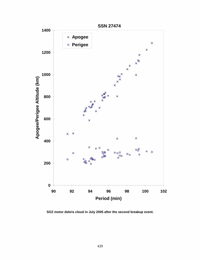
439
SOZ motor debris cloud in July 2005 after the second breakup event.
0
200
400
600
800
1000
1200
1400
90 92 94 96 98 100 102
Period (min)
Apo
gee/
Perig
ee A
ltitu
de (k
m)
Apogee Perigee
SSN 27474

440
COSMOS 2392 ULLAGE MOTOR 2002-037F 27475 SATELLITE DATA TYPE: Mission Related Debris OWNER: CIS LAUNCH DATE: 25.63 Jul 2002 DRY MASS (KG): 55 MAIN BODY: Ellipsoid; 0.6 m diameter by 1 m length MAJOR APPENDAGES: None ATTITUDE CONTROL: None ENERGY SOURCES: On-board propellant EVENT DATA DATE: 29 Oct 2004 LOCATION: Unknown TIME: Unknown ASSESSED CAUSE: Propulsion ALTITUDE: Unknown PRE-EVENT ELEMENTS EPOCH: 04302.83463691 MEAN ANOMALY: 199.8896 RIGHT ASCENSION: 56.1075 MEAN MOTION: 15.09294101 INCLINATION: 63.6401 MEAN MOTION DOT/2: 0.00146672 ECCENTRICITY: 0.0436823 MEAN MOTION DOT DOT/6: 0.000010335 ARG. OF PERIGEE: 161.8395 BSTAR: 0.00073391 DEBRIS CLOUD DATA MAXIMUM ∆P: Unknown MAXIMUM ∆I: Unknown COMMENTS This event marks the 31st known breakup of a Proton Blok DM SOZ ullage motor since 1984. More than 60 debris were detected by the Naval electronic fence. No debris were in orbit long enough to be cataloged. REFERENCE DOCUMENTS History of Soviet/Russian Satellite Fragmentations-A Joint U.S.-Russian Investigation, N. L. Johnson et al, Kaman Sciences Corporation, October 1995. “Recent Satellite Breakups”, The Orbital Debris Quarterly News, NASA JSC, January 2005. Available online at https://orbitaldebris.jsc.nasa.gov/quarterly-news/pdfs/ODQNv9i1.pdf.

441
Insufficient data to construct a Gabbard diagram.

442
COSMOS 2399 2003-035A 27856 SATELLITE DATA TYPE: Payload OWNER: CIS LAUNCH DATE: 12.60 Aug 2003 DRY MASS (KG): ~6000 MAIN BODY: Cylinder; 2.4 m diameter by 7 m length MAJOR APPENDAGES: Solar Arrays ATTITUDE CONTROL: Active, 3-axis ENERGY SOURCES: On-board propellants, explosive charge EVENT DATA DATE: 9 Dec 2003 LOCATION: 64.8 N, 135.4 E (asc) TIME: 0129Z ASSESSED CAUSE: Deliberate ALTITUDE: 189.33 km PRE-EVENT ELEMENTS EPOCH: 03342.92270571 MEAN ANOMALY: 296.9639 RIGHT ASCENSION: 136.8172 MEAN MOTION: 16.22926227 INCLINATION: 64.9062 MEAN MOTION DOT/2: 0.01025110 ECCENTRICITY: 0.0055948 MEAN MOTION DOT DOT/6: 0.0000073532 ARG. OF PERIGEE: 63.7269 BSTAR: 0.00028689 DEBRIS CLOUD DATA MAXIMUM ∆P: 7.34 min* MAXIMUM ∆I: 0.08 deg* * Based on uncataloged debris data COMMENTS Cosmos 2399 was the seventh of the Cosmos 2031 class of spacecraft that debuted in 1989 but was not flown since 1997. In all six previous missions (1989-1997), the spacecraft was deliberately exploded at the end of mission. Previous missions of this type include Cosmos 2031, Cosmos 2101, Cosmos 2163, Cosmos 2225, Cosmos 2262, and Cosmos 2343. All such events have occurred over Eastern Russia. Highest previous piece count for large debris for this class of vehicle was 180, although more were probably created. Approximately 22 debris were detected by the SSN. Due to the low altitude of the breakup, the debris were short-lived. REFERENCE DOCUMENT “Satellite Fragmentations in 2003”, The Orbital Debris Quarterly News, NASA JSC, January 2004. Available online at https://orbitaldebris.jsc.nasa.gov/quarterly-news/pdfs/ODQNv8i1.pdf.
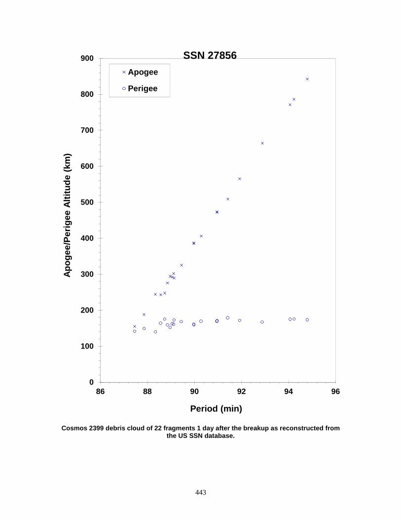
443
Cosmos 2399 debris cloud of 22 fragments 1 day after the breakup as reconstructed from
the US SSN database.
0
100
200
300
400
500
600
700
800
900
86 88 90 92 94 96
Apog
ee/P
erig
ee A
ltitu
de (k
m)
Period (min)
Apogee
Perigee
SSN 27856
444
ALOS-1 R/B 2006-002B 28932 SATELLITE DATA TYPE: Rocket Body OWNER: Japan LAUNCH DATE: 24.06 Jan 2006 DRY MASS (KG): ~3000 MAIN BODY: Cylinder; 4.0 m diameter by 10.6 m length MAJOR APPENDAGES: None ATTITUDE CONTROL: None at time of event ENERGY SOURCES: On-board propellant FIRST EVENT DATA DATE: 8 Aug 2006 LOCATION: 5N, 131E (asc) TIME: 1407 GMT ASSESSED CAUSE: Unknown ALTITUDE: 685 km SECOND EVENT DATA DATE: 27 Aug 2006 LOCATION: 76S, 135E (asc) TIME: 1618 GMT ASSESSED CAUSE: Unknown ALTITUDE: 695 km PRE-EVENT ELEMENTS EPOCH: 06220.18259253 MEAN ANOMALY: 147.5075 RIGHT ASCENSION: 300.3416 MEAN MOTION: 14.8204486 INCLINATION: 98.1944 MEAN MOTION DOT/2: 0.00000143 ECCENTRICITY: 0.0106899 MEAN MOTION DOT DOT/6: 0.0 ARG. OF PERIGEE: 211.9623 BSTAR: 0.000023737 DEBRIS CLOUD DATA MAXIMUM ∆P: 1.0 min MAXIMUM ∆I: 0.0 deg COMMENTS The first event shed four pieces of debris, the second event shed more than 15 pieces. The parent experienced little if any change in orbit and the debris from both events were ejected with relatively low delta velocity from the parent, making a propulsion explosion unlikely for the cause of breakup. All the debris appeared to have high area-to-mass ratios, causing the ejected debris to decay within six months of the events. The parent body remains in orbit as of August 2007. Another H-IIA second stage (2006-037B) experienced two minor fragmentation events a few months later. Possible source of the debris is light-weight insulation material. REFERENCE DOCUMENTS “Three More Satellites Involved in Fragmentations”, The Orbital Debris Quarterly News, NASA JSC, October 2006. Available online at https://orbitaldebris.jsc.nasa.gov/quarterly-news/pdfs/ODQNv10i4.pdf.
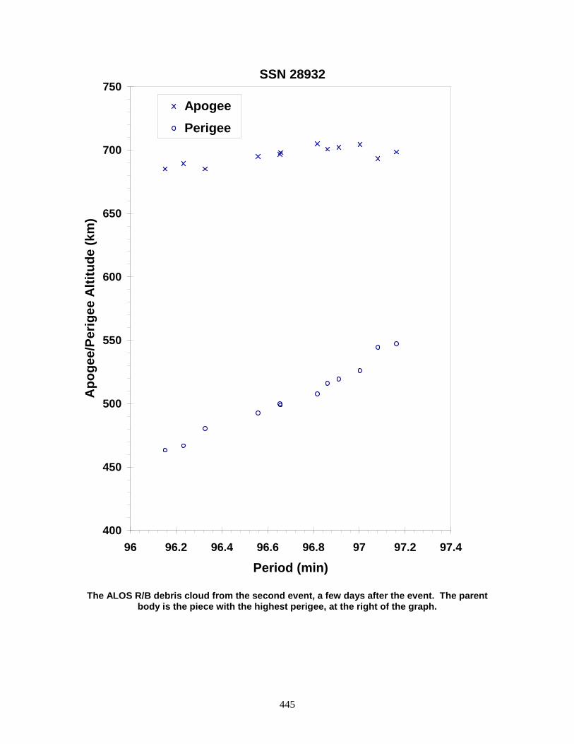
445
The ALOS R/B debris cloud from the second event, a few days after the event. The parent
body is the piece with the highest perigee, at the right of the graph.
400
450
500
550
600
650
700
750
96 96.2 96.4 96.6 96.8 97 97.2 97.4
Period (min)
Apo
gee/
Perig
ee A
ltitu
de (k
m)
Apogee Perigee
SSN 28932

446
ARABSAT 4 BRIZ-M R/B 2006-006B 28944 SATELLITE DATA TYPE: Rocket Body OWNER: CIS LAUNCH DATE: 28.84 Feb 2006 DRY MASS (KG): 2600 MAIN BODY: Cylinder; 2.5 m diameter by 2.6 m length MAJOR APPENDAGES: None ATTITUDE CONTROL: None ENERGY SOURCES: On-board propellants EVENT DATA DATE: 19 Feb 2007 LOCATION: 31S, 135E (asc) TIME: 1721 GMT ASSESSED CAUSE: Propulsion ALTITUDE: 7640 km PRE-EVENT ELEMENTS EPOCH: 07050.57138199 MEAN ANOMALY: 134.5177 RIGHT ASCENSION: 213.0506 MEAN MOTION: 5.25304422 INCLINATION: 51.4995 MEAN MOTION DOT/2: 0.00000185 ECCENTRICITY: 0.5083307 MEAN MOTION DOT DOT/6: 0.0 ARG. OF PERIGEE: 197.8403 BSTAR: 0.00029198 DEBRIS CLOUD DATA MAXIMUM ∆P: 48.6 min MAXIMUM ∆I: 2.6 deg COMMENTS This upper stage malfunctioned, stranding itself and its payload in an eccentric orbit. The cause of the breakup is assessed to be related to the ~8 metric tons of unused propellants. The breakup occurred over Southern Australia, and was captured by three amateur astronomers, which showed expansion of a faint cloud around the exploded fourth stage. Over a thousand objects 10 cm or larger were estimated by the US SSN. REFERENCE DOCUMENT “Two More Incidents Add to Growing Space Debris”, Space News, February 26, 2007. “Four Satellite Breakups in February Add to Debris Population”, The Orbital Debris Quarterly News, NASA JSC, April 2007. Available online at https://orbitaldebris.jsc.nasa.gov/quarterly-news/pdfs/ODQNv11i2.pdf.

447
The Briz-M R/B debris cloud of uncataloged fragments 10 days after the event.
0
2000
4000
6000
8000
10000
12000
14000
16000
18000
200 225 250 275 300 325
Period (min)
Apo
gee/
Perig
ee A
ltitu
de (k
m)
Apogee Perigee
SSN 28944
448
YAOGAN 1 2006-015A 29092 SATELLITE DATA TYPE: Payload OWNER: PRC LAUNCH DATE: 26 Apr 2006 DRY MASS (KG): 2721.0 MAIN BODY: unknown MAJOR APPENDAGES: unknown ATTITUDE CONTROL: unknown ENERGY SOURCES: unknown EVENT DATA DATE: 4 Feb 2010 LOCATION: 56.3N, 140.7E (asc) TIME: 0649 GMT ASSESSED CAUSE: Unknown ALTITUDE: 636.516 km PRE-EVENT ELEMENTS EPOCH: 10034.53017668 MEAN ANOMALY: 264.9880 RIGHT ASCENSION: 28.5835 MEAN MOTION: 14.80351885 INCLINATION: 97.8566 MEAN MOTION DOT/2: -0.00000264 ECCENTRICITY: 0.0001956 MEAN MOTION DOT DOT/6: 0.0 ARG. OF PERIGEE: 95.1578 BSTAR: -0.000027865 DEBRIS CLOUD DATA MAXIMUM ∆P: 5.4 min MAXIMUM ∆I: 0.4 deg COMMENTS REFERENCE DOCUMENT “Old and New Satellite Breakups Identified”, The Orbital Debris Quarterly News, NASA JSC, April 2010. Available online at https://orbitaldebris.jsc.nasa.gov/quarterly-news/ODQNv14i2.pdf.
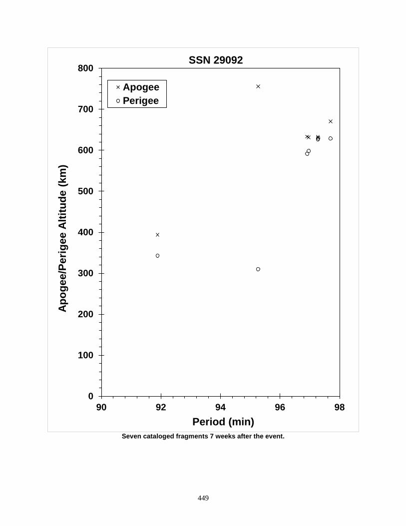
449
Seven cataloged fragments 7 weeks after the event.
0
100
200
300
400
500
600
700
800
90 92 94 96 98
Apog
ee/P
erig
ee A
ltitu
de (k
m)
Period (min)
SSN 29092
ApogeePerigee

450
COSMOS 2421 2006-026A 29247 SATELLITE DATA TYPE: Payload OWNER: CIS LAUNCH DATE: 25 Jun 2006 DRY MASS (KG): 3200 MAIN BODY: 1.7 m diameter x 17 m long cylinder MAJOR APPENDAGES: solar panels ATTITUDE CONTROL: active, three-axis ENERGY SOURCES: on-board propellants, explosive charge (?) EVENT DATA DATE: 14 Mar 2008 LOCATION: 52.247S, 24.130E (dsc) TIME: 0429 GMT ASSESSED CAUSE: Unknown ALTITUDE: 420.242 km PRE-EVENT ELEMENTS EPOCH: 08073.77012377 MEAN ANOMALY: 145.3615 RIGHT ASCENSION: 48.2539 MEAN MOTION: 15.52978992 INCLINATION: 65.0437 MEAN MOTION DOT/2: 0.00011420 ECCENTRICITY: 0.0014765 MEAN MOTION DOT DOT/6: 0.0 ARG. OF PERIGEE: 285.7968 BSTAR: 0.00018556 DEBRIS CLOUD DATA MAXIMUM ∆P: 8.1 min MAXIMUM ∆I: 1.4 deg COMMENTS Cosmos 2421 was the last of the Soviet/Russian series of Electronic Ocean Reconnaissance Satellite (EORSAT) spacecraft. As with other spacecraft of the Cosmos 699 class, the high area-to-mass ratio of the majority of debris produced in this event resulted in a short residence on-orbit and no long-term environmental hazard. REFERENCE DOCUMENT “Satellite Breakups During First Quarter of 2008”, The Orbital Debris Quarterly News, NASA JSC, April 2008. Available online at https://orbitaldebris.jsc.nasa.gov/quarterly-news/ODQNv12i2.pdf.

451
The COSMOS 2421 debris cloud, including 509 fragments cataloged up to 48 weeks after
the event.
0
200
400
600
800
1000
1200
1400
85 90 95 100 105
Apog
ee/P
erig
ee A
ltitu
de (k
m)
Period (min)
SSN 29247
Apogee (up to 48 wks. Post BU)Perigee (up to 48 wks. Post BU)Apogee (up to 2 mo. Post BU)Perigee (up to 2 mo. Post BU)

452
IGS 3A R/B 2006-037B 29394 SATELLITE DATA TYPE: Rocket Body OWNER: Japan LAUNCH DATE: 11.19 Sep 2006 DRY MASS (KG): ~3000 MAIN BODY: Cylinder; 4.0 m diameter by 10.6 m length MAJOR APPENDAGES: None ATTITUDE CONTROL: None at time of event ENERGY SOURCES: On-board propellant EVENT DATA DATE: 28 Dec 2006 LOCATION: 58S, 131E (asc) TIME: 1729 GMT ASSESSED CAUSE: Unknown ALTITUDE: 470 km PRE-EVENT ELEMENTS EPOCH: 06361.50058695 MEAN ANOMALY: 347.5081 RIGHT ASCENSION: 117.7926 MEAN MOTION: 15.35084918 INCLINATION: 97.2357 MEAN MOTION DOT/2: 0.00002838 ECCENTRICITY: 0.0043549 MEAN MOTION DOT DOT/6: 0.0 ARG. OF PERIGEE: 12.7250 BSTAR: 0.000083212 DEBRIS CLOUD DATA MAXIMUM ∆P: 2.6 min MAXIMUM ∆I: 0.2 deg COMMENTS This was the second fragmentation of an H-IIA second stage in 2006 (see 2006-002B). No debris were cataloged from the first event, but at least 20 new objects were detected. However, the rocket body experienced a second fragmentation event on 25 July 2007, releasing at least 15 new debris. REFERENCE DOCUMENT “Significant Increase in Satellite Breakups During 2006”, The Orbital Debris Quarterly News, NASA JSC, January 2007. Available online at https://orbitaldebris.jsc.nasa.gov/quarterly-news/pdfs/ODQNv11i1.pdf.
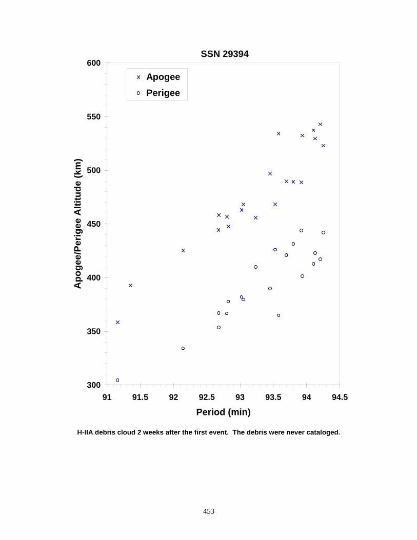
453
H-IIA debris cloud 2 weeks after the first event. The debris were never cataloged.
300
350
400
450
500
550
600
91 91.5 92 92.5 93 93.5 94 94.5
Period (min)
Apo
gee/
Perig
ee A
ltitu
de (k
m)
Apogee Perigee
SSN 29394
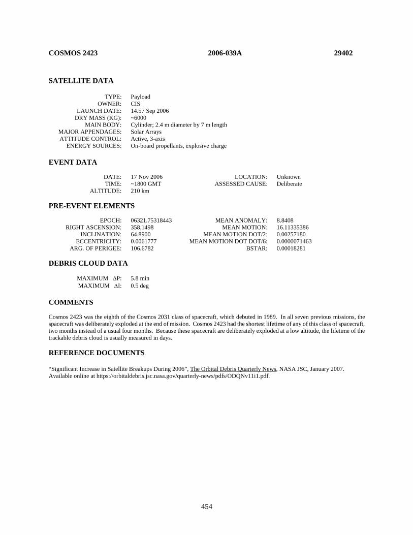
454
COSMOS 2423 2006-039A 29402 SATELLITE DATA TYPE: Payload OWNER: CIS LAUNCH DATE: 14.57 Sep 2006 DRY MASS (KG): ~6000 MAIN BODY: Cylinder; 2.4 m diameter by 7 m length MAJOR APPENDAGES: Solar Arrays ATTITUDE CONTROL: Active, 3-axis ENERGY SOURCES: On-board propellants, explosive charge EVENT DATA DATE: 17 Nov 2006 LOCATION: Unknown TIME: ~1800 GMT ASSESSED CAUSE: Deliberate ALTITUDE: 210 km PRE-EVENT ELEMENTS EPOCH: 06321.75318443 MEAN ANOMALY: 8.8408 RIGHT ASCENSION: 358.1498 MEAN MOTION: 16.11335386 INCLINATION: 64.8900 MEAN MOTION DOT/2: 0.00257180 ECCENTRICITY: 0.0061777 MEAN MOTION DOT DOT/6: 0.0000071463 ARG. OF PERIGEE: 106.6782 BSTAR: 0.00018281 DEBRIS CLOUD DATA MAXIMUM ∆P: 5.8 min MAXIMUM ∆I: 0.5 deg COMMENTS Cosmos 2423 was the eighth of the Cosmos 2031 class of spacecraft, which debuted in 1989. In all seven previous missions, the spacecraft was deliberately exploded at the end of mission. Cosmos 2423 had the shortest lifetime of any of this class of spacecraft, two months instead of a usual four months. Because these spacecraft are deliberately exploded at a low altitude, the lifetime of the trackable debris cloud is usually measured in days. REFERENCE DOCUMENTS “Significant Increase in Satellite Breakups During 2006”, The Orbital Debris Quarterly News, NASA JSC, January 2007. Available online at https://orbitaldebris.jsc.nasa.gov/quarterly-news/pdfs/ODQNv11i1.pdf.
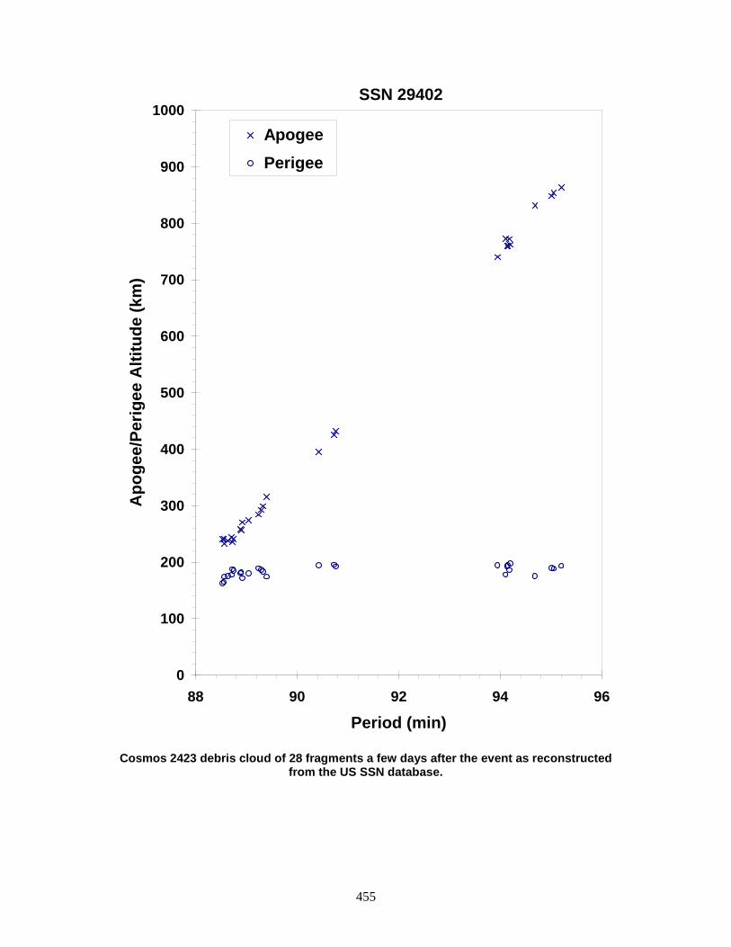
455
Cosmos 2423 debris cloud of 28 fragments a few days after the event as reconstructed
from the US SSN database.
0
100
200
300
400
500
600
700
800
900
1000
88 90 92 94 96
Period (min)
Apo
gee/
Perig
ee A
ltitu
de (k
m)
Apogee Perigee
SSN 29402

456
DMSP 5D-3 F17 R/B 2006-050B 29523 SATELLITE DATA TYPE: Rocket Body OWNER: US LAUNCH DATE: 4.58 Nov 2006 DRY MASS (KG): 2850 MAIN BODY: Cylinder; 4.0 m diameter by 12 m length MAJOR APPENDAGES: None ATTITUDE CONTROL: None at time of event ENERGY SOURCES: On-board propellant EVENT DATA DATE: 4 Nov 2006 LOCATION: Unknown TIME: Unknown ASSESSED CAUSE: Unknown ALTITUDE: Unknown PRE-EVENT ELEMENTS EPOCH: 06308.62553010 MEAN ANOMALY: 119.1776 RIGHT ASCENSION: 307.4245 MEAN MOTION: 14.13676442 INCLINATION: 98.7885 MEAN MOTION DOT/2: -0.00000044 ECCENTRICITY: 0.0022197 MEAN MOTION DOT DOT/6: 0.0 ARG. OF PERIGEE: 240.7178 BSTAR: 0.0 DEBRIS CLOUD DATA MAXIMUM ∆P: 9.5 min MAXIMUM ∆I: 0.3 deg COMMENTS This was the first major event associated with a Delta IV second stage. Debris appeared to separate from the parent body in a retrograde direction soon after orbit insertion. Over 60 pieces were eventually cataloged from this event. The rocket body did not see any performance degradation and was reentered directly after payload delivery. The cause of the debris release was investigated to ensure any countermeasures can be implemented for future Delta IV missions. REFERENCE DOCUMENTS “Significant Increase in Satellite Breakups During 2006”, The Orbital Debris Quarterly News, NASA JSC, January 2007. Available online at https://orbitaldebris.jsc.nasa.gov/quarterly-news/pdfs/ODQNv11i1.pdf.

457
Delta 4 debris cloud of 62 fragments less than two weeks after the event.
200
300
400
500
600
700
800
900
90 92 94 96 98 100 102 104
Period (min)
Apo
gee/
Perig
ee A
ltitu
de (k
m)
Apogee Perigee
SSN 29523
458
USA 193 2006-057A 29651 SATELLITE DATA TYPE: Payload OWNER: USA LAUNCH DATE: 14 Dec 2006 DRY MASS (KG): unknown MAIN BODY: unknown MAJOR APPENDAGES: unknown ATTITUDE CONTROL: unknown ENERGY SOURCES: unknown EVENT DATA DATE: 21 Feb 2008 LOCATION: 8.813N, 189.023E (asc) TIME: 0326 GMT ASSESSED CAUSE: Deliberate (HVI) ALTITUDE: 247.769 km PRE-EVENT ELEMENTS - unavailable EPOCH: MEAN ANOMALY: RIGHT ASCENSION: MEAN MOTION: INCLINATION: MEAN MOTION DOT/2: ECCENTRICITY: MEAN MOTION DOT DOT/6: ARG. OF PERIGEE: BSTAR: DEBRIS CLOUD DATA MAXIMUM ∆P: unknown min MAXIMUM ∆I: unknown deg COMMENTS This spacecraft was intentionally destroyed in order to minimize the potential ground hazard should it reenter with its fuel tank intact. NASA’s standard reentry hazard analysis tool indicated a high probability that frozen/slush hydrazine monopropellant would survive intact to the ground, presenting a significant chemical hazard. The intercept was accomplished by an SM-3 missile launched by the US Navy Aegis cruiser USS Lake Erie. REFERENCE DOCUMENT “Satellite Breakups During First Quarter of 2008”, The Orbital Debris Quarterly News, NASA JSC, April 2008. Available online at https://orbitaldebris.jsc.nasa.gov/quarterly-news/ODQNv12i2.pdf.

459
The USA 193 debris cloud, including 174 fragments cataloged up to 1 month after the
event.
460
COSMOS 2424-2426 ULLAGE MOTOR 2006-062G 29680 SATELLITE DATA TYPE: Mission Related Debris OWNER: CIS LAUNCH DATE: 25 Dec 2006 DRY MASS (KG): 55 MAIN BODY: ellipsoid; 0.6 m diameter x 1 m length MAJOR APPENDAGES: none ATTITUDE CONTROL: none ENERGY SOURCES: on-board propellants EVENT DATA DATE: 27 July 2016 LOCATION: 15.38S, 124.1E (asc) TIME: 0119 GMT ASSESSED CAUSE: Propulsion ALTITUDE: 18551.3 km PRE-EVENT ELEMENTS EPOCH: 16208.24667120 MEAN ANOMALY: 356.6314 RIGHT ASCENSION: 261.9075 MEAN MOTION: 4.23611820 INCLINATION: 64.7769 MEAN MOTION DOT/2: +0.00000237 ECCENTRICITY: 0.5783296 MEAN MOTION DOT DOT/6: 0.00000 ARG. OF PERIGEE: 27.2587 BSTAR: +0.00030726 DEBRIS CLOUD DATA MAXIMUM ∆P: 10 min MAXIMUM ∆I: 0.7 deg COMMENTS This event was the 46th known fragmentation of Blok-DM ullage motors. The breakups are believed to be caused by residual propellants. Russian officials have been aware of the problem since 1992 and have made design changes, although the date of full implementation is unknown. Multiple small debris were observed by the SSN, but due to difficulties in cataloging fragments in elliptical and deep-space orbits many more fragments could be present. REFERENCE DOCUMENTS History of Soviet/Russian Satellite Fragmentations: A Joint U.S.-Russian Investigation. N.L. Johnson et al. Kaman Sciences Corporation, October 2005. “New SOZ Breakup in July 2016”, The Orbital Debris Quarterly News, NASA JSC, October 2016. Available online at https://www.orbitaldebris.jsc.nasa.gov/quarterly-news/pdfs/odqnv20i4.pdf.
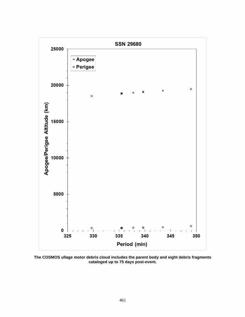
461
The COSMOS ullage motor debris cloud includes the parent body and eight debris fragments cataloged up to 75 days post-event.

462
BEIDOU 1D R/B 2007-003B 30324 SATELLITE DATA TYPE: Rocket Body OWNER: PRC LAUNCH DATE: 02 Feb 2007 DRY MASS (KG): 3062 MAIN BODY: Cylinder; 3.0 m diameter x 12.4 m long MAJOR APPENDAGES: none ATTITUDE CONTROL: status unknown at time of event ENERGY SOURCES: on-board propellants EVENT DATA DATE: 02 Feb 2007 LOCATION: Unknown TIME: Unknown ASSESSED CAUSE: Unknown ALTITUDE: Unknown PRE-EVENT ELEMENTS EPOCH: 07033.76400703 MEAN ANOMALY: 43.007 RIGHT ASCENSION: 9.4841 MEAN MOTION: 1.91693848 INCLINATION: 25.0136 MEAN MOTION DOT/2: -0.00001383 ECCENTRICITY: 0.7597957 MEAN MOTION DOT DOT/6: 0.0000011914 ARG. OF PERIGEE: 179.8053 BSTAR: 0.0 DEBRIS CLOUD DATA MAXIMUM ∆P: 5.5 min MAXIMUM ∆I: 0.2 deg COMMENTS In the 14th edition of this work, this event was identified as being associated with the payload. To quote: “The spacecraft experienced problems soon after insertion into a geosynchronous transfer orbit. In March 2007, the spacecraft was recovered and maneuvered into GEO. As many as 100 debris were detected by the US SSN.” This event was more recently identified as being associated with the CZ-3A R/B. This is now recognized as being the first known CZ-3 third stage fragmentation event. REFERENCE DOCUMENT “Four Satellite Breakups in February Add to Debris Population”, The Orbital Debris Quarterly News, NASA JSC, January 2007. Available online at https://orbitaldebris.jsc.nasa.gov/quarterly-news/pdfs/ODQNv11i2.pdf.
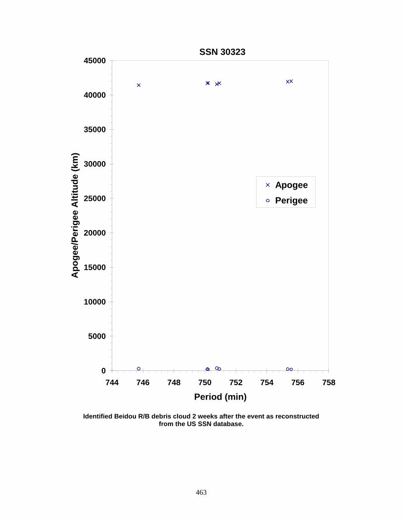
463
Identified Beidou R/B debris cloud 2 weeks after the event as reconstructed
from the US SSN database.
0
5000
10000
15000
20000
25000
30000
35000
40000
45000
744 746 748 750 752 754 756 758
Period (min)
Apo
gee/
Perig
ee A
ltitu
de (k
m)
Apogee Perigee
SSN 30323

464
IGS 4A/4B R/B DEBRIS 2007-005E 30590 SATELLITE DATA TYPE: Mission Related Debris OWNER: Japan LAUNCH DATE: 24 Feb 2007 DRY MASS (KG): unknown MAIN BODY: truncated cone; 4.070 m diameter tapering to < 1.98 m diameter x ~ 1.5 m length MAJOR APPENDAGES: none ATTITUDE CONTROL: none ENERGY SOURCES: unknown EVENT DATA DATE: 23 Dec 2010 LOCATION: Unknown TIME: 1600 GMT ASSESSED CAUSE: Unknown ALTITUDE: Unknown PRE-EVENT ELEMENTS EPOCH: 10357.22196763 MEAN ANOMALY: 297.1353 RIGHT ASCENSION: 114.8768 MEAN MOTION: 15.43699236 INCLINATION: 97.3356 MEAN MOTION DOT/2: 0.00018749 ECCENTRICITY: 0.0005569 MEAN MOTION DOT DOT/6: 0.0 ARG. OF PERIGEE: 63.1040 BSTAR: 0.0 DEBRIS CLOUD DATA MAXIMUM ∆P: 0.9 min MAXIMUM ∆I: 0.0 deg COMMENTS Parent object is the upper cap section of the three-piece Kawasaki Heavy Industries, Ltd. 4/4D-LC dual payload fairing’s lower payload encapsulation system. Six objects were initially observed and three were officially cataloged. These objects displayed large area-to-mass ratios (0.38-0.85 m2/kg) and decayed rapidly from orbit. Subsequently an additional 11 pieces entered the catalog. All have decayed. REFERENCE DOCUMENT “New Satellite Fragmentations Add to Debris Population”, The Orbital Debris Quarterly News, NASA JSC, January 2011. Available online at https://orbitaldebris.jsc.nasa.gov/quarterly-news/pdfs/ODQNv15i1.pdf.
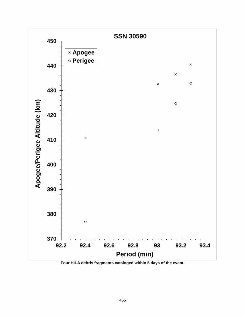
465
Four HII-A debris fragments cataloged within 5 days of the event.
370
380
390
400
410
420
430
440
450
92.2 92.4 92.6 92.8 93 93.2 93.4
Apog
ee/P
erig
ee A
ltitu
de (k
m)
Period (min)
SSN 30590
ApogeePerigee

466
COSMOS 2428 2007-029A 31792 SATELLITE DATA TYPE: Payload OWNER: CIS LAUNCH DATE: 26 Oct 2007 DRY MASS (KG): 3250 MAIN BODY: stepped cylinder MAJOR APPENDAGES: solar panels & antennas ATTITUDE CONTROL: gravity gradient (passive) ENERGY SOURCES: unknown at time of event EVENT DATA DATE: 10 May 2014 LOCATION: TBD TIME: 2024 GMT ASSESSED CAUSE: Unknown ALTITUDE: TBD km PRE-EVENT ELEMENTS EPOCH: 14129.36499359 MEAN ANOMALY: 236.8999 RIGHT ASCENSION: 270.8988 MEAN MOTION: 14.12320352 INCLINATION: 70.9495 MEAN MOTION DOT/2: 0.00000475 ECCENTRICITY: 0.0010837 MEAN MOTION DOT DOT/6: 0.00000 ARG. OF PERIGEE: 200.7382 BSTAR: 0.0028345 DEBRIS CLOUD DATA MAXIMUM ∆P: TBD min MAXIMUM ∆I: TBD deg COMMENTS Cosmos 2428 is believed to be the last Tselina-2 class spacecraft flown. Approximately 17 fragments have been observed, but only nine have been officially cataloged. Of these, eight have decayed from orbit by 23 September 2014. The remaining fragment is in an orbit similar to four pieces of previously-cataloged SL-16 launch vehicle debris, and may not be related to this event. REFERENCE DOCUMENTS “Flurry of Small Breakups in First Half of 2014”, The Orbital Debris Quarterly News, NASA JSC, July 2014. Available online at https://orbitaldebris.jsc.nasa.gov/quarterly-news/pdfs/ODQNv18i3.pdf.
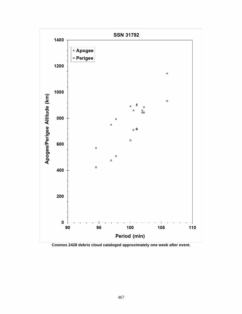
467
Cosmos 2428 debris cloud cataloged approximately one week after event.
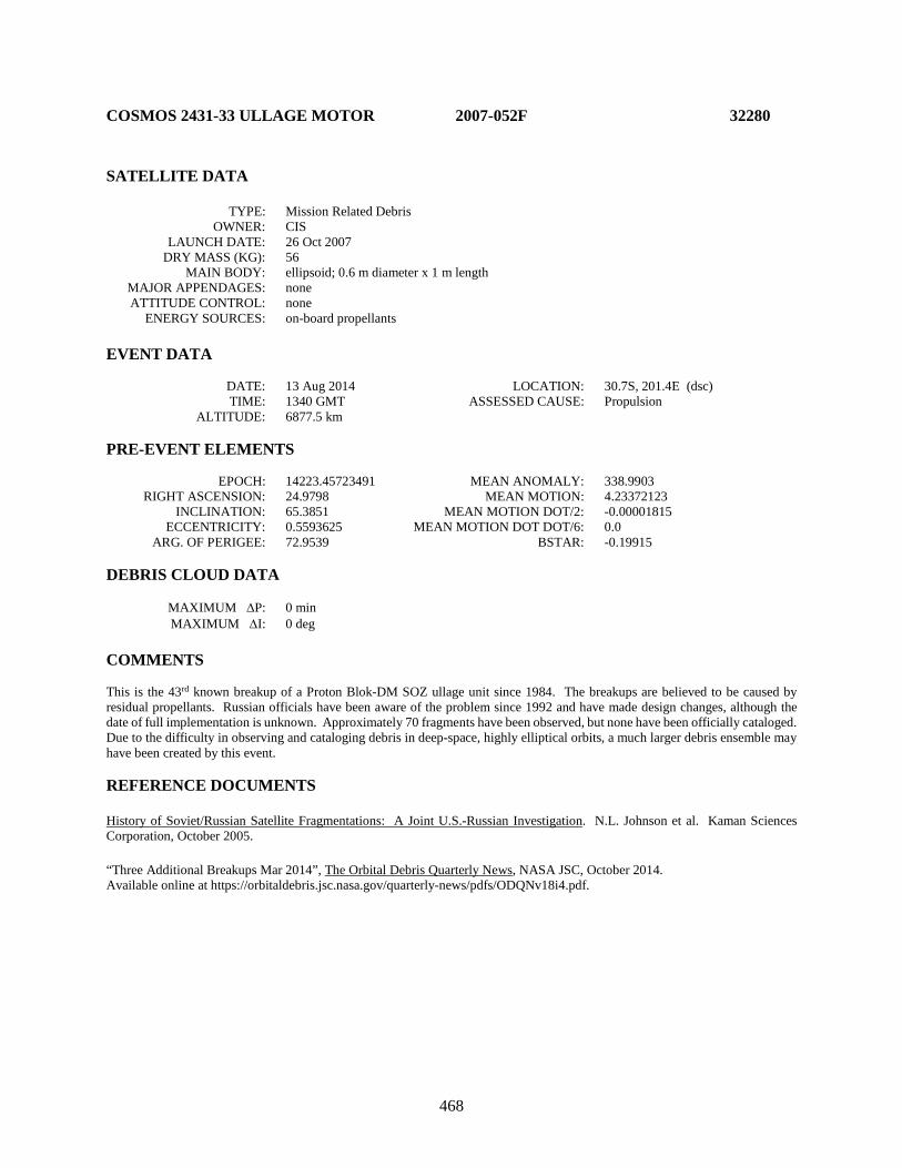
468
COSMOS 2431-33 ULLAGE MOTOR 2007-052F 32280 SATELLITE DATA TYPE: Mission Related Debris OWNER: CIS LAUNCH DATE: 26 Oct 2007 DRY MASS (KG): 56 MAIN BODY: ellipsoid; 0.6 m diameter x 1 m length MAJOR APPENDAGES: none ATTITUDE CONTROL: none ENERGY SOURCES: on-board propellants EVENT DATA DATE: 13 Aug 2014 LOCATION: 30.7S, 201.4E (dsc) TIME: 1340 GMT ASSESSED CAUSE: Propulsion ALTITUDE: 6877.5 km PRE-EVENT ELEMENTS EPOCH: 14223.45723491 MEAN ANOMALY: 338.9903 RIGHT ASCENSION: 24.9798 MEAN MOTION: 4.23372123 INCLINATION: 65.3851 MEAN MOTION DOT/2: -0.00001815 ECCENTRICITY: 0.5593625 MEAN MOTION DOT DOT/6: 0.0 ARG. OF PERIGEE: 72.9539 BSTAR: -0.19915 DEBRIS CLOUD DATA MAXIMUM ∆P: 0 min MAXIMUM ∆I: 0 deg COMMENTS This is the 43rd known breakup of a Proton Blok-DM SOZ ullage unit since 1984. The breakups are believed to be caused by residual propellants. Russian officials have been aware of the problem since 1992 and have made design changes, although the date of full implementation is unknown. Approximately 70 fragments have been observed, but none have been officially cataloged. Due to the difficulty in observing and cataloging debris in deep-space, highly elliptical orbits, a much larger debris ensemble may have been created by this event. REFERENCE DOCUMENTS History of Soviet/Russian Satellite Fragmentations: A Joint U.S.-Russian Investigation. N.L. Johnson et al. Kaman Sciences Corporation, October 2005. “Three Additional Breakups Mar 2014”, The Orbital Debris Quarterly News, NASA JSC, October 2014. Available online at https://orbitaldebris.jsc.nasa.gov/quarterly-news/pdfs/ODQNv18i4.pdf.
469
Insufficient data to construct a Gabbard diagram.

470
USA 197 R/B 2007-054B 32288 SATELLITE DATA TYPE: Rocket Body OWNER: USA LAUNCH DATE: 11 Nov 2007 DRY MASS (KG): 3,490.0 MAIN BODY: stepped cylinder: 5 m (max) diameter x 13.7 m length MAJOR APPENDAGES: none ATTITUDE CONTROL: active; 3 axis RCS ENERGY SOURCES: on-board propellants EVENT DATA DATE: 11 Nov 2007 LOCATION: Unknown TIME: Unknown ASSESSED CAUSE: Unknown ALTITUDE: Unknown PRE-EVENT ELEMENTS - unavailable EPOCH: MEAN ANOMALY: RIGHT ASCENSION: MEAN MOTION: INCLINATION: MEAN MOTION DOT/2: ECCENTRICITY: MEAN MOTION DOT DOT/6: ARG. OF PERIGEE: BSTAR: DEBRIS CLOUD DATA MAXIMUM ∆P: unknown min MAXIMUM ∆I: unknown deg COMMENTS First operational launch of a Delta IV Heavy (Delta 9250H), though second launch of the 5 m-diameter cryogenic second stage. The flight plan called for the second stage to insert itself and the payload into three distinct orbits: a LEO parking orbit; a geosynchronous transfer orbit; and a near geosynchronous final orbit. At least two dozen debris appear to have been released in the parking orbit of approximately 1575 km x 220 km. The debris release event had no apparent effect on subsequent orbit maneuvers, and the payload was successfully delivered to the planned final orbit. REFERENCE DOCUMENT “Two Minor Fragmentations End Worst Debris Year Ever”, The Orbital Debris Quarterly News, NASA JSC, January 2008. Available online at http://orbitaldebris.jsc.nasa.gov/newsletter/pdfs/ODQNv12i1.pdf.
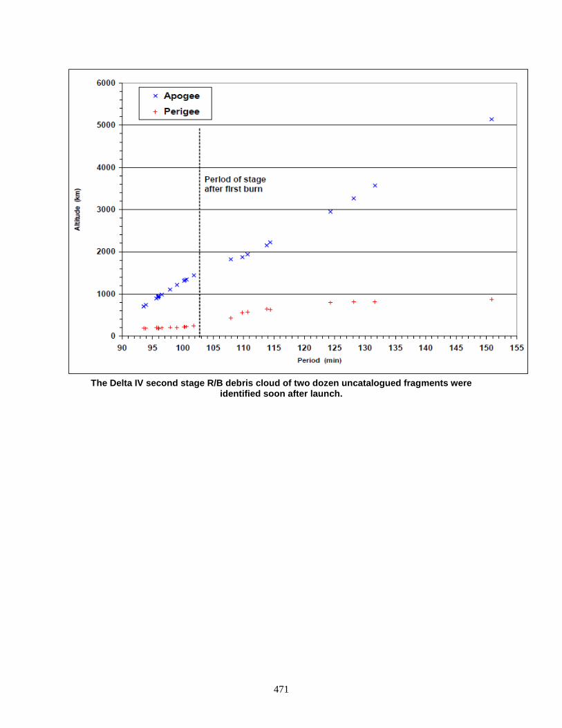
471
The Delta IV second stage R/B debris cloud of two dozen uncatalogued fragments were
identified soon after launch.

472
COSMOS 2434-36 ULLAGE MOTOR 2007-065G 32399 SATELLITE DATA TYPE: Mission Related Debris OWNER: CIS LAUNCH DATE: 25 Dec 2007 DRY MASS (KG): 56.0 MAIN BODY: ellipsoid; 0.6 m diameter x 1 m length MAJOR APPENDAGES: none ATTITUDE CONTROL: none ENERGY SOURCES: on-board propellants EVENT DATA DATE: 18 Aug 2011 LOCATION: Unknown TIME: Unknown ASSESSED CAUSE: Unknown ALTITUDE: Unknown PRE-EVENT ELEMENTS EPOCH: 11230.12943848 MEAN ANOMALY: 279.9120 RIGHT ASCENSION: 286.1835 MEAN MOTION: 4.23764448 INCLINATION: 65.0463 MEAN MOTION DOT/2: 0.00000228 ECCENTRICITY: 0.5712685 MEAN MOTION DOT DOT/6: 0.0 ARG. OF PERIGEE: 140.2548 BSTAR: 0.0 DEBRIS CLOUD DATA MAXIMUM ∆P: 0.0 min MAXIMUM ∆I: 0.0 deg COMMENTS This event was the 38th known fragmentation of Blok-DM ullage motors. The breakups are believed to be caused by residual propellants. Russian officials have been aware of the problem since 1992 and have made design changes, although the date of full implementation is unknown. Although some small debris were observed by the SSN, none have been officially cataloged. REFERENCE DOCUMENT History of Soviet/Russian Satellite Fragmentations: A Joint U.S.-Russian Investigation. N.L. Johnson et al. Kaman Sciences Corporation, October 2005. “Only a Few Minor Satellite Breakups in 2011”, The Orbital Debris Quarterly News, NASA JSC, January 2012. Available online at http://orbitaldebris.jsc.nasa.gov/newsletter/pdfs/ODQNv16i1.pdf.

473
Insufficient data to construct a Gabbard diagram.
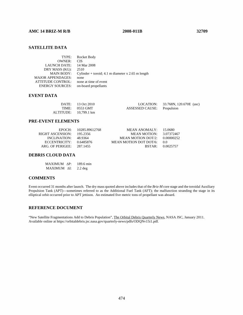
474
AMC 14 BRIZ-M R/B 2008-011B 32709 SATELLITE DATA TYPE: Rocket Body OWNER: CIS LAUNCH DATE: 14 Mar 2008 DRY MASS (KG): 2510 MAIN BODY: Cylinder + toroid; 4.1 m diameter x 2.65 m length MAJOR APPENDAGES: none ATTITUDE CONTROL: none at time of event ENERGY SOURCES: on-board propellants EVENT DATA DATE: 13 Oct 2010 LOCATION: 33.768N, 120.670E (asc) TIME: 0553 GMT ASSESSED CAUSE: Propulsion ALTITUDE: 10,799.1 km PRE-EVENT ELEMENTS EPOCH: 10285.89612768 MEAN ANOMALY: 15.0680 RIGHT ASCENSION: 195.2356 MEAN MOTION: 3.07372467 INCLINATION: 48.9364 MEAN MOTION DOT/2: 0.00000252 ECCENTRICITY: 0.6485876 MEAN MOTION DOT DOT/6: 0.0 ARG. OF PERIGEE: 287.1455 BSTAR: 0.0025757 DEBRIS CLOUD DATA MAXIMUM ∆P: 189.6 min MAXIMUM ∆I: 2.2 deg COMMENTS Event occurred 31 months after launch. The dry mass quoted above includes that of the Briz-M core stage and the toroidal Auxiliary Propulsion Tank (APT)—sometimes referred to as the Additional Fuel Tank (AFT); the malfunction stranding the stage in its elliptical orbit occurred prior to APT jettison. An estimated five metric tons of propellant was aboard. REFERENCE DOCUMENT “New Satellite Fragmentations Add to Debris Population”, The Orbital Debris Quarterly News, NASA JSC, January 2011. Available online at https://orbitaldebris.jsc.nasa.gov/quarterly-news/pdfs/ODQNv15i1.pdf.
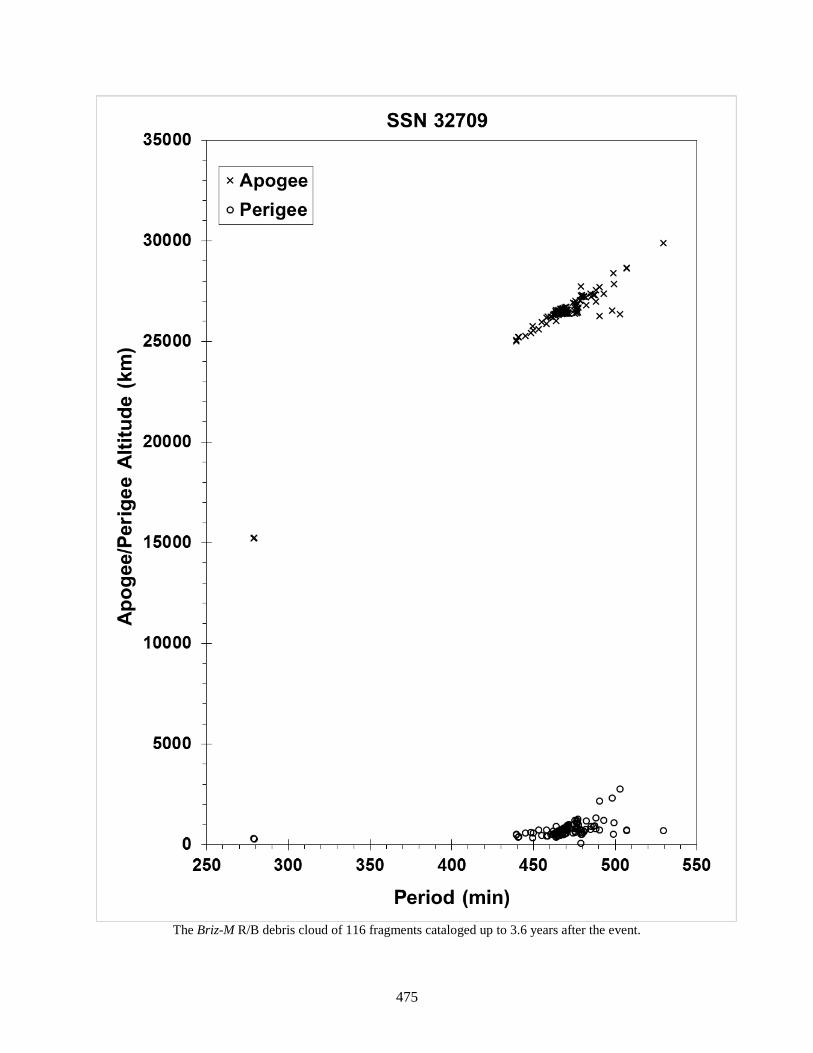
475
The Briz-M R/B debris cloud of 116 fragments cataloged up to 3.6 years after the event.

476
COSMOS 2442-44 ULLAGE MOTOR 2008-046H 33385 SATELLITE DATA TYPE: Mission Related Debris OWNER: CIS LAUNCH DATE: 25 Sep 2008 DRY MASS (KG): 56 MAIN BODY: ellipsoid; 0.6 m diameter x 1 m length MAJOR APPENDAGES: none ATTITUDE CONTROL: none ENERGY SOURCES: on-board propellants EVENT DATA DATE: 20 May 2014 LOCATION: 62.4S, 148.5E (asc) TIME: 0032 GMT ASSESSED CAUSE: Propulsion ALTITUDE: 16,288.3 km PRE-EVENT ELEMENTS EPOCH: 14135.66838656 MEAN ANOMALY: 322.5973 RIGHT ASCENSION: 154.3825 MEAN MOTION: 4.23142676 INCLINATION: 65.3219 MEAN MOTION DOT/2: -0.00000189 ECCENTRICITY: 0.5517601 MEAN MOTION DOT DOT/6: 0.00000 ARG. OF PERIGEE: 101.3049 BSTAR: 0.00000 DEBRIS CLOUD DATA MAXIMUM ∆P: 12.7 min MAXIMUM ∆I: 0.3 deg COMMENTS This is the 40th known breakup of a Proton Blok-DM SOZ ullage unit since 1984. The breakups are believed to be caused by residual propellants. Russian officials have been aware of the problem since 1992 and have made design changes, although the date of full implementation is unknown. Due to the difficulty in observing and cataloging debris in deep-space, highly elliptical orbits, a debris ensemble much larger than that cataloged may have been created by this event. REFERENCE DOCUMENT History of Soviet/Russian Satellite Fragmentations: A Joint U.S.-Russian Investigation. N.L. Johnson et al. Kaman Sciences Corporation, October 2005. “Flurry of Small Breakups in First Half of 2014”, The Orbital Debris Quarterly News, NASA JSC, July 2014. Available online at https://orbitaldebris.jsc.nasa.gov/quarterly-news/pdfs/ODQNv18i3.pdf.
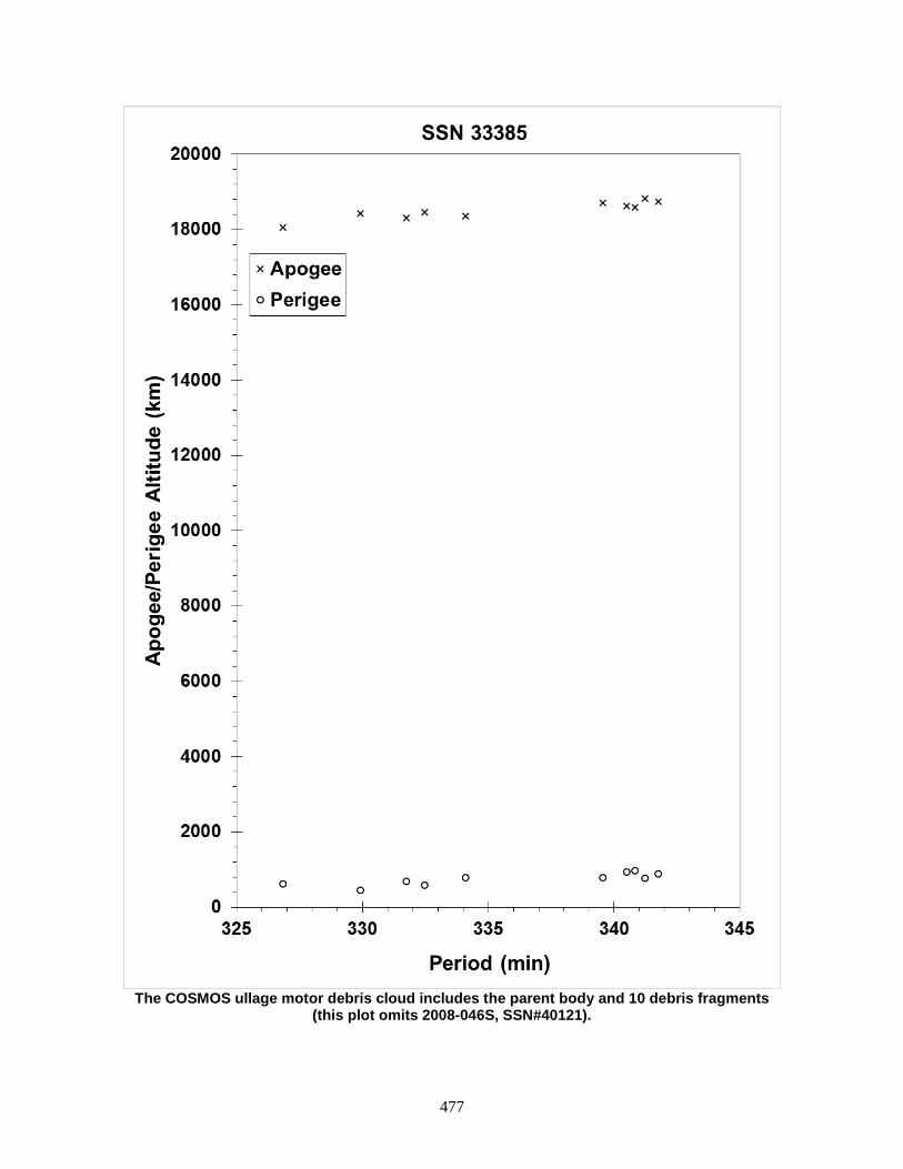
477
The COSMOS ullage motor debris cloud includes the parent body and 10 debris fragments
(this plot omits 2008-046S, SSN#40121).

478
COSMOS 2447-2449 ULLAGE MOTOR 2008-067G 33472 SATELLITE DATA TYPE: Mission Related Debris OWNER: CIS LAUNCH DATE: 25 Dec 2008 DRY MASS (KG): 56.0 MAIN BODY: ellipsoid; 0.6 m diameter x 1 m length MAJOR APPENDAGES: none ATTITUDE CONTROL: none ENERGY SOURCES: on-board propellants EVENT DATA DATE: 26 Mar 2016 LOCATION: 46.91S, 285.50E (asc) TIME: 1212 GMT ASSESSED CAUSE: Propulsion ALTITUDE: 18075.34 km PRE-EVENT ELEMENTS EPOCH: 16084.51547544 MEAN ANOMALY: 341.8531 RIGHT ASCENSION: 57.2039 MEAN MOTION: 4.23930172 INCLINATION: 65.3219 MEAN MOTION DOT/2: +0.00000377 ECCENTRICITY: 0.5630529 MEAN MOTION DOT DOT/6: 0.00000 ARG. OF PERIGEE: 66.1764 BSTAR: +0.0029410 DEBRIS CLOUD DATA MAXIMUM ∆P: 11.4 min MAXIMUM ∆I: 0.2 deg COMMENTS This event was the 44th known fragmentation of Blok-DM ullage motors. The breakups are believed to be caused by residual propellants. Russian officials have been aware of the problem since 1992 and have made design changes, although the date of full implementation is unknown. Twenty-one pieces were initially observed. Due to the difficulty of cataloging debris in elliptical and deep space orbits there may be many more debris fragments than this number or those cataloged. REFERENCE DOCUMENTS History of Soviet/Russian Satellite Fragmentations: A Joint U.S.-Russian Investigation. N.L. Johnson et al. Kaman Sciences Corporation, October 2005. “Russian SOZ Unit Breakup Up in March”, The Orbital Debris Quarterly News, NASA JSC, April 2016. Available online at https://www.orbitaldebris.jsc.nasa.gov/quarterly-news/pdfs/odqnv20i1-2.pdf.
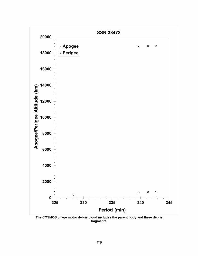
479
The COSMOS ullage motor debris cloud includes the parent body and three debris
fragments.

480
COSMOS 2447-2449 ULLAGE MOTOR 2008-067H 33473 SATELLITE DATA TYPE: Mission Related Debris OWNER: CIS LAUNCH DATE: 25 Dec 2008 DRY MASS (KG): 56.0 MAIN BODY: ellipsoid; 0.6 m diameter x 1 m length MAJOR APPENDAGES: none ATTITUDE CONTROL: none ENERGY SOURCES: on-board propellants EVENT DATA DATE: 1 June 2016 LOCATION: 32.86S, 339.90E (dsc) TIME: 0925 GMT ASSESSED CAUSE: Propulsion ALTITUDE: 7148.03 km PRE-EVENT ELEMENTS EPOCH: 16152.95219263 MEAN ANOMALY: 5.7190 RIGHT ASCENSION: 28.8315 MEAN MOTION: 4.23951640 INCLINATION: 65.2630 MEAN MOTION DOT/2: +0.00005748 ECCENTRICITY: 0.5609396 MEAN MOTION DOT DOT/6: 0.00000 ARG. OF PERIGEE: 72.5352 BSTAR: +0.053896 DEBRIS CLOUD DATA MAXIMUM ∆P: 8.9 min MAXIMUM ∆I: 0.4 deg COMMENTS This event was the 45th known fragmentation of Blok-DM ullage motors. The breakups are believed to be caused by residual propellants. Russian officials have been aware of the problem since 1992 and have made design changes, although the date of full implementation is unknown. Due to the difficulty of cataloging debris in elliptical and deep space orbits there may be many more debris fragments than those cataloged. REFERENCE DOCUMENTS History of Soviet/Russian Satellite Fragmentations: A Joint U.S.-Russian Investigation. N.L. Johnson et al. Kaman Sciences Corporation, October 2005. “Two Additional Russian Breakups in 2016”, The Orbital Debris Quarterly News, NASA JSC, July 2016. Available online at https://www.orbitaldebris.jsc.nasa.gov/quarterly-news/pdfs/odqnv20i3.pdf.

481
The COSMOS ullage motor debris cloud includes the parent body and 11 debris fragments cataloged up to 37 days post-event.

482
BEIDOU G2 2009-018A 34779 SATELLITE DATA TYPE: payload OWNER: PRC LAUNCH DATE: 14 Apr. 2009 DRY MASS (KG): 1100 MAIN BODY: DFH-3 bus derivative; box 2.2 m long x 1.72 m wide x 2.0 m high MAJOR APPENDAGES: solar arrays and antennas ATTITUDE CONTROL: three-axis stabilized ENERGY SOURCES: propellant, batteries, reaction wheels EVENT DATA DATE: 29 June 2016 LOCATION: unknown TIME: unknown ASSESSED CAUSE: unknown ALTITUDE: unknown PRE-EVENT ELEMENTS EPOCH: 16180.12570702 MEAN ANOMALY: 164.3864 RIGHT ASCENSION: 61.3828 MEAN MOTION: 1.00365151 INCLINATION: 4.7106 MEAN MOTION DOT/2: -0.00000325 ECCENTRICITY: 0.0089308 MEAN MOTION DOT DOT/6: 0.00000 ARG. OF PERIGEE: 195.1803 BSTAR: 0.00000 DEBRIS CLOUD DATA MAXIMUM ∆P: unknown MAXIMUM ∆I: unknown COMMENTS This spacecraft was the first launch of the People’s Republic of China (PRC) BeiDou 2nd generation regional navigation satellites in the Compass Navigation Satellite System, and is sometimes labeled as “Beidou-2 G2” to indicate 2nd generation, 2nd Geosynchronous (GEO) spacecraft (the –G1 was launched in 2010). This designation (“G”) identifies it as being apart from the PRC’s middle Earth orbit (MEO, “M”) or inclined GEO (“IG”) spacecraft constellations. The spacecraft uses the Chinese Academy of Spacecraft Technology (CAST) Dong Fang Hong 3 (DFH-3) communication satellite-heritage bus with the specialized navigational payload. The spacecraft fragmented into at least five pieces, though no fragments have entered the catalog to accompany the parent body. Due to the difficulty in cataloging fragments in deep-space orbits there may be many more fragments resident at or near GEO. REFERENCE DOCUMENTS “BeiDou G2 Spacecraft Fragments in Geosynchronous Orbit”, The Orbital Debris Quarterly News, NASA JSC, October 2016. Available online at https://www.orbitaldebris.jsc.nasa.gov/quarterly-news/pdfs/odqnv20i4.pdf.
483
Insufficient data to construct a Gabbard diagram.
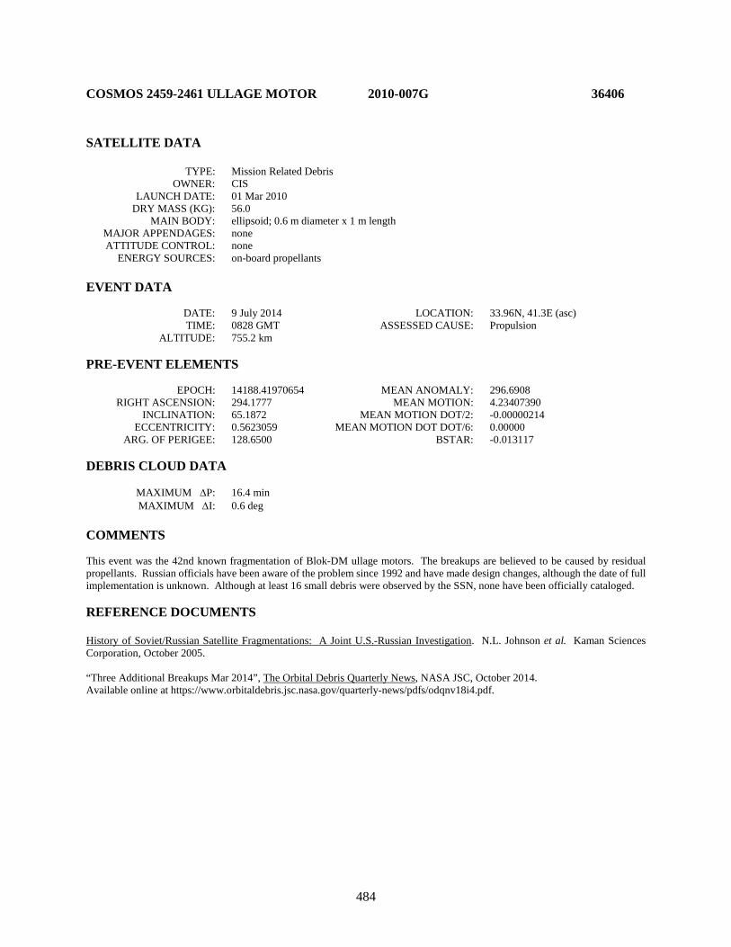
484
COSMOS 2459-2461 ULLAGE MOTOR 2010-007G 36406 SATELLITE DATA TYPE: Mission Related Debris OWNER: CIS LAUNCH DATE: 01 Mar 2010 DRY MASS (KG): 56.0 MAIN BODY: ellipsoid; 0.6 m diameter x 1 m length MAJOR APPENDAGES: none ATTITUDE CONTROL: none ENERGY SOURCES: on-board propellants EVENT DATA DATE: 9 July 2014 LOCATION: 33.96N, 41.3E (asc) TIME: 0828 GMT ASSESSED CAUSE: Propulsion ALTITUDE: 755.2 km PRE-EVENT ELEMENTS EPOCH: 14188.41970654 MEAN ANOMALY: 296.6908 RIGHT ASCENSION: 294.1777 MEAN MOTION: 4.23407390 INCLINATION: 65.1872 MEAN MOTION DOT/2: -0.00000214 ECCENTRICITY: 0.5623059 MEAN MOTION DOT DOT/6: 0.00000 ARG. OF PERIGEE: 128.6500 BSTAR: -0.013117 DEBRIS CLOUD DATA MAXIMUM ∆P: 16.4 min MAXIMUM ∆I: 0.6 deg COMMENTS This event was the 42nd known fragmentation of Blok-DM ullage motors. The breakups are believed to be caused by residual propellants. Russian officials have been aware of the problem since 1992 and have made design changes, although the date of full implementation is unknown. Although at least 16 small debris were observed by the SSN, none have been officially cataloged. REFERENCE DOCUMENTS History of Soviet/Russian Satellite Fragmentations: A Joint U.S.-Russian Investigation. N.L. Johnson et al. Kaman Sciences Corporation, October 2005. “Three Additional Breakups Mar 2014”, The Orbital Debris Quarterly News, NASA JSC, October 2014. Available online at https://www.orbitaldebris.jsc.nasa.gov/quarterly-news/pdfs/odqnv18i4.pdf.
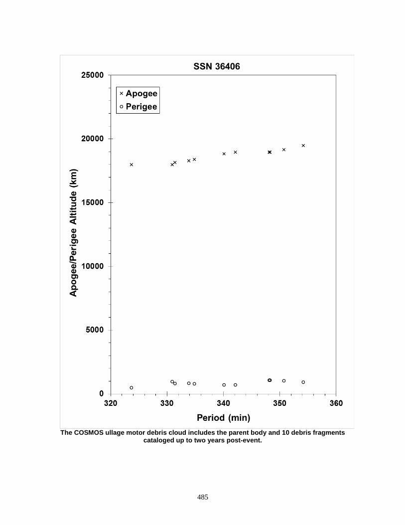
485
The COSMOS ullage motor debris cloud includes the parent body and 10 debris fragments
cataloged up to two years post-event.

486
COSMOS 2459-2461 ULLAGE MOTOR 2010-007H 36407 SATELLITE DATA TYPE: Mission Related Debris OWNER: CIS LAUNCH DATE: 01 Mar 2010 DRY MASS (KG): 56.0 MAIN BODY: ellipsoid; 0.6 m diameter x 1 m length MAJOR APPENDAGES: none ATTITUDE CONTROL: none ENERGY SOURCES: on-board propellants EVENT DATA DATE: 22 May 2018 LOCATION: 8.59S, 90.0E (asc) TIME: 0206 GMT ASSESSED CAUSE: Propulsion ALTITUDE: 13745.8 km PRE-EVENT ELEMENTS EPOCH: 18141.55091406 MEAN ANOMALY: 348.7596 RIGHT ASCENSION: 177.3536 MEAN MOTION: 4.23280497 INCLINATION: 65.0720 MEAN MOTION DOT/2: -0.00001771 ECCENTRICITY: 0.5676424 MEAN MOTION DOT DOT/6: 0.00000 ARG. OF PERIGEE: 45.9342 BSTAR: -0.0089882 DEBRIS CLOUD DATA MAXIMUM ∆P: 23.7 min MAXIMUM ∆I: 1 deg COMMENTS This event was the 48th known fragmentation of Blok-DM ullage motors. The breakups are believed to be caused by residual propellants. Russian officials have been aware of the problem since 1992 and have made design changes, although the date of full implementation is unknown. Although at least 60 small debris were observed by the SSN, many more fragments could be present due to difficulties in cataloging fragments in elliptical and deep-space orbits. REFERENCE DOCUMENTS History of Soviet/Russian Satellite Fragmentations: A Joint U.S.-Russian Investigation. N.L. Johnson et al. Kaman Sciences Corporation, October 2005. “A SOZ Unit Breakup Predicted and Observed in May 2018”, The Orbital Debris Quarterly News, NASA JSC, September 2018. Available online at https://www.orbitaldebris.jsc.nasa.gov/quarterly-news/pdfs/odqnv22i3.pdf.

487
The COSMOS ullage motor debris cloud includes the parent body and 10 debris fragments
cataloged up to 64 days post-event.
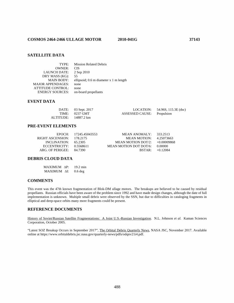
488
COSMOS 2464-2466 ULLAGE MOTOR 2010-041G 37143 SATELLITE DATA TYPE: Mission Related Debris OWNER: CIS LAUNCH DATE: 2 Sep 2010 DRY MASS (KG): 55 MAIN BODY: ellipsoid; 0.6 m diameter x 1 m length MAJOR APPENDAGES: none ATTITUDE CONTROL: none ENERGY SOURCES: on-board propellants EVENT DATA DATE: 03 Sept. 2017 LOCATION: 54.96S, 115.3E (dsc) TIME: 0237 GMT ASSESSED CAUSE: Propulsion ALTITUDE: 14887.2 km PRE-EVENT ELEMENTS EPOCH: 17245.45043553 MEAN ANOMALY: 333.2513 RIGHT ASCENSION: 178.2175 MEAN MOTION: 4.25073663 INCLINATION: 65.2305 MEAN MOTION DOT/2: +0.00009868 ECCENTRICITY: 0.5568611 MEAN MOTION DOT DOT/6: 0.00000 ARG. OF PERIGEE: 84.7390 BSTAR: +0.12084 DEBRIS CLOUD DATA MAXIMUM ∆P: 19.2 min MAXIMUM ∆I: 0.6 deg COMMENTS This event was the 47th known fragmentation of Blok-DM ullage motors. The breakups are believed to be caused by residual propellants. Russian officials have been aware of the problem since 1992 and have made design changes, although the date of full implementation is unknown. Multiple small debris were observed by the SSN, but due to difficulties in cataloging fragments in elliptical and deep-space orbits many more fragments could be present. REFERENCE DOCUMENTS History of Soviet/Russian Satellite Fragmentations: A Joint U.S.-Russian Investigation. N.L. Johnson et al. Kaman Sciences Corporation, October 2005. “Latest SOZ Breakup Occurs in September 2017”, The Orbital Debris Quarterly News, NASA JSC, November 2017. Available online at https://www.orbitaldebris.jsc.nasa.gov/quarterly-news/pdfs/odqnv21i4.pdf.
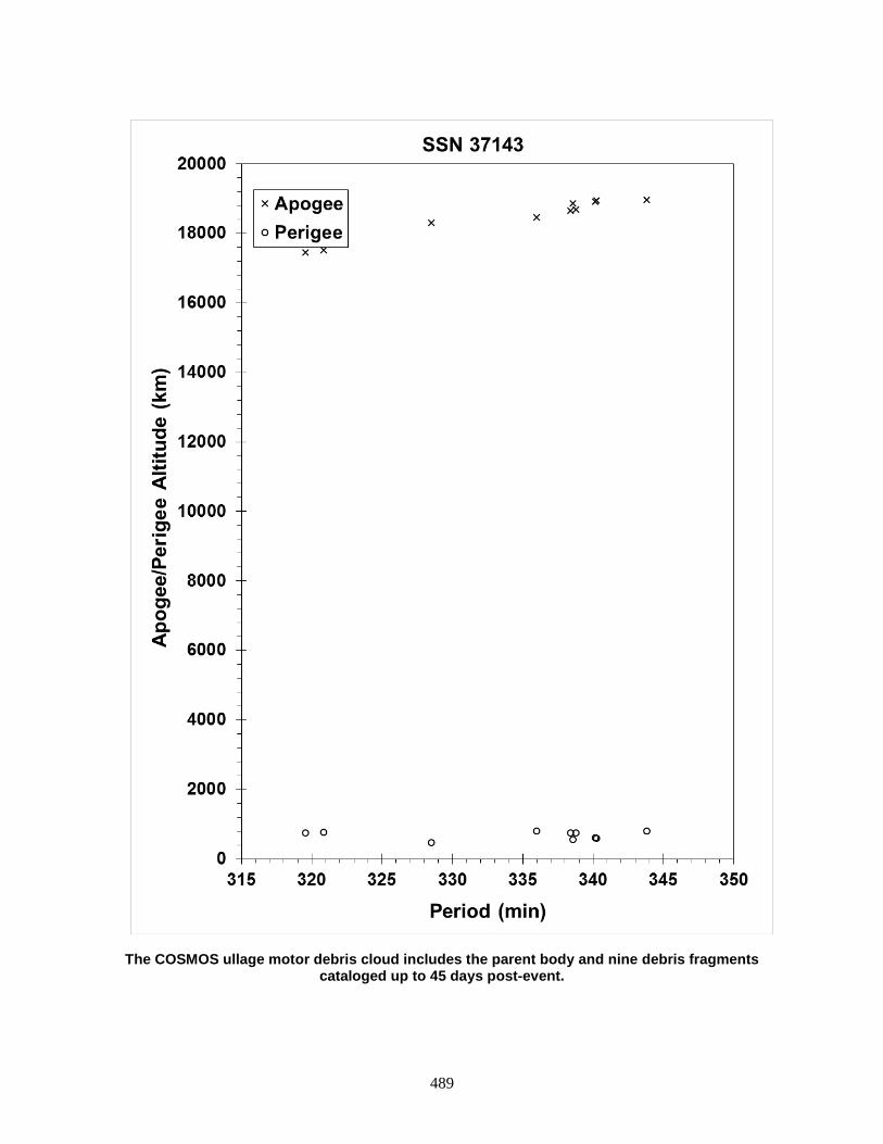
489
The COSMOS ullage motor debris cloud includes the parent body and nine debris fragments cataloged up to 45 days post-event.
490
CHINASAT 6A R/B 2010-042B 37151 SATELLITE DATA TYPE: Rocket Body OWNER: PRC LAUNCH DATE: 4 Sep 2010 DRY MASS (KG): 3062 MAIN BODY: Cylinder; 3.0 m diameter x 12.4 m long MAJOR APPENDAGES: none ATTITUDE CONTROL: status unknown at time of event ENERGY SOURCES: on-board propellants EVENT DATA DATE: ~4 Sep 2010 LOCATION: Unknown TIME: Unknown ASSESSED CAUSE: Unknown ALTITUDE: Unknown PRE-EVENT ELEMENTS EPOCH: 10247.43584147 MEAN ANOMALY: 183.2812 RIGHT ASCENSION: 224.5993 MEAN MOTION: 1.91160163 INCLINATION: 25.2307 MEAN MOTION DOT/2: 0.00001931 ECCENTRICITY: 0.7603361 MEAN MOTION DOT DOT/6: -0.11660e-5 ARG. OF PERIGEE: 179.3215 BSTAR: 0.0001 DEBRIS CLOUD DATA MAXIMUM ∆P: 74.8 min MAXIMUM ∆I: 3.2 deg COMMENTS Detected by software. This was the second fragmentation of a CZ-3 third stage. Like the prior event, this event occurred within hours of launch and separation of the payload. Cataloging was delayed by high eccentricity of orbit.
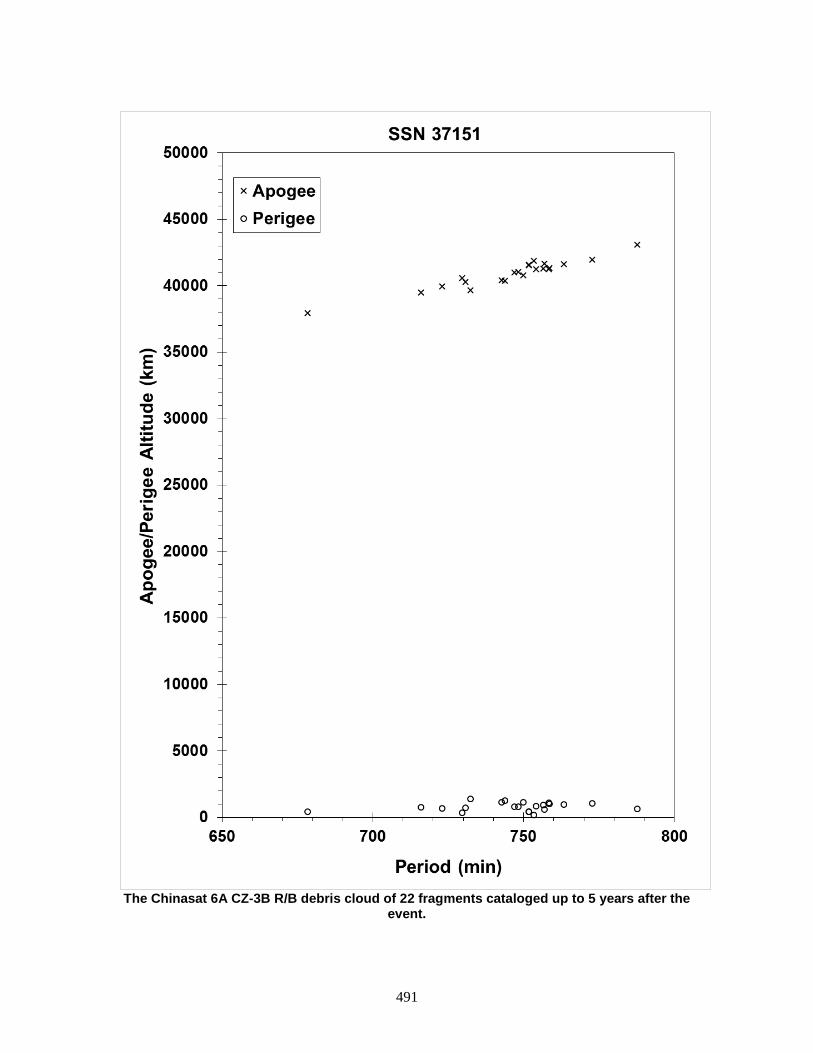
491
The Chinasat 6A CZ-3B R/B debris cloud of 22 fragments cataloged up to 5 years after the
event.
492
BEIDOU G4 R/B 2010-057B 37211 SATELLITE DATA TYPE: Rocket Body OWNER: PRC LAUNCH DATE: 1 Nov 2010 DRY MASS (KG): 3062 MAIN BODY: Cylinder; 3.0 m diameter x 12.4 m long MAJOR APPENDAGES: none ATTITUDE CONTROL: status unknown at time of event ENERGY SOURCES: on-board propellants EVENT DATA DATE: 1 Nov 2010 LOCATION: 4.407S, 328.867E (asc) TIME: 1731 GMT ASSESSED CAUSE: Unknown ALTITUDE: 33,072.2 km PRE-EVENT ELEMENTS EPOCH: 10305.30000000 MEAN ANOMALY: 132.3340 RIGHT ASCENSION: 284.6090 MEAN MOTION: 2.28504000 INCLINATION: 20.4700 MEAN MOTION DOT/2: 0.00000669 ECCENTRICITY: 0.7313927 MEAN MOTION DOT DOT/6: -0.74391e-6 ARG. OF PERIGEE: 179.8990 BSTAR: 0.0 DEBRIS CLOUD DATA MAXIMUM ∆P: 446.6 min MAXIMUM ∆I: 3.1 deg COMMENTS This was the third known fragmentation of a CZ-3 third stage. Like the prior event, this event occurred within hours of launch and separation of the payload. REFERENCE DOCUMENT “New Satellite Fragmentations Add to Debris Population”, The Orbital Debris Quarterly News, NASA JSC, January 2011. Available online at http://orbitaldebris.jsc.nasa.gov/newsletter/pdfs/ODQNv15i1.pdf.
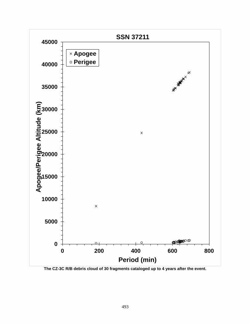
493
The CZ-3C R/B debris cloud of 30 fragments cataloged up to 4 years after the event.
0
5000
10000
15000
20000
25000
30000
35000
40000
45000
0 200 400 600 800
Apog
ee/P
erig
ee A
ltitu
de (k
m)
Period (min)
SSN 37211
ApogeePerigee
494
SL-23 DEB 2011-037B 37756 SATELLITE DATA TYPE: Mission Related Debris OWNER: CIS LAUNCH DATE: 21 Sep 2000 DRY MASS (KG): 375 MAIN BODY: toroidal fuel tank; 0.821 m tank diameter x 3.44 m overall diameter MAJOR APPENDAGES: none ATTITUDE CONTROL: none ENERGY SOURCES: unknown EVENT DATA DATE: 3-4 Aug 2015 LOCATION: unknown TIME: unknown ASSESSED CAUSE: unknown ALTITUDE: unknown PRE-EVENT ELEMENTS EPOCH: 15214.44003403 MEAN ANOMALY: 298.4148 RIGHT ASCENSION: 218.9517 MEAN MOTION: 11.24281384 INCLINATION: 51.4462 MEAN MOTION DOT/2: 0.00000437 ECCENTRICITY: 0.1913343 MEAN MOTION DOT DOT/6: 0.00000 ARG. OF PERIGEE: 234.4912 BSTAR: 0.0011788 DEBRIS CLOUD DATA MAXIMUM ∆P: TBD min MAXIMUM ∆I: TBD deg COMMENTS The parent body is assumed to be the jettisonable auxiliary fuel tank discarded by the Fregat-SB upper stage. Twenty-four debris were observed but none have entered the SSN catalog. REFERENCE DOCUMENTS “Fragmentation of Fregat Upper Stage Debris”, The Orbital Debris Quarterly News, NASA JSC, April 2016. Available online at http://orbitaldebris.jsc.nasa.gov/newsletter/pdfs/ODQNv20i1-2.pdf.
495
Insufficient data to construct a Gabbard diagram.

496
NIGCOMSAT 1R R/B 2011-077B 38015 SATELLITE DATA TYPE: Rocket Body OWNER: PRC LAUNCH DATE: 19 Dec 2011 DRY MASS (KG): 3062 MAIN BODY: Cylinder; 3.0 m diameter x 12.4 m length MAJOR APPENDAGES: none ATTITUDE CONTROL: status unknown at time of event ENERGY SOURCES: on-board propellants EVENT DATA DATE: 21 Dec 2011 LOCATION: Unknown TIME: Unknown ASSESSED CAUSE: Unknown ALTITUDE: Unknown PRE-EVENT ELEMENTS EPOCH: 11355.16500251 MEAN ANOMALY: 285.0544 RIGHT ASCENSION: 335.3965 MEAN MOTION: 1.91939558 INCLINATION: 24.3335 MEAN MOTION DOT/2: -0.00001209 ECCENTRICITY: 0.7584148 MEAN MOTION DOT DOT/6: 0.0 ARG. OF PERIGEE: 179.8362 BSTAR: -0.00031775 DEBRIS CLOUD DATA MAXIMUM ∆P: 91.3 min MAXIMUM ∆I: 2.4 deg COMMENTS This was the fourth fragmentation of a CZ-3 third stage. Like prior events, this event occurred within two days of launch and separation of the payload. REFERENCE DOCUMENT “Only a few minor satellite breakups in 2011”, The Orbital Debris Quarterly News, NASA JSC, January 2012. Available online at http://orbitaldebris.jsc.nasa.gov/newsletter/pdfs/ODQNv16i1.pdf.
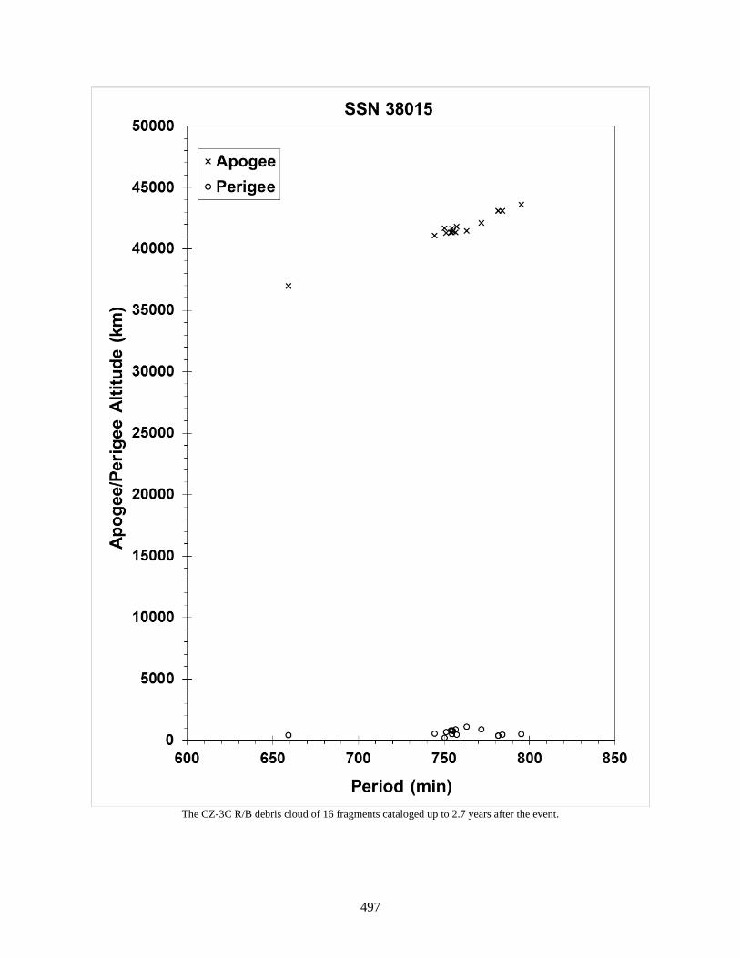
497
The CZ-3C R/B debris cloud of 16 fragments cataloged up to 2.7 years after the event.
498
BEIDOU G5 R/B 2012-008B 38092 SATELLITE DATA TYPE: Rocket Body OWNER: PRC LAUNCH DATE: 24 Feb 2012 DRY MASS (KG): 3062 MAIN BODY: Cylinder; 3.0 m diameter x 12.4 m length MAJOR APPENDAGES: none ATTITUDE CONTROL: status unknown at time of event ENERGY SOURCES: on-board propellants EVENT DATA DATE: 26 Feb 2012 LOCATION: Unknown TIME: Unknown ASSESSED CAUSE: Unknown ALTITUDE: Unknown PRE-EVENT ELEMENTS EPOCH: 12056.56279906 MEAN ANOMALY: 353.3665 RIGHT ASCENSION: 35.2298 MEAN MOTION: 2.27377203 INCLINATION: 20.6965 MEAN MOTION DOT/2: 0.00007641 ECCENTRICITY: 0.7327583 MEAN MOTION DOT DOT/6: 0.0000012139 ARG. OF PERIGEE: 180.1005 BSTAR: 0.00010000 DEBRIS CLOUD DATA MAXIMUM ∆P: 56.1 min MAXIMUM ∆I: 2.6 deg COMMENTS This was the fifth fragmentation of a CZ-3 third stage. Like its preceding event, this event occurred within two days of launch and separation of the Beidou G5 spacecraft. REFERENCE DOCUMENT “Chinese Rocket Body Explosions Continue”, The Orbital Debris Quarterly News, NASA JSC, April 2012. Available online at https://orbitaldebris.jsc.nasa.gov/quarterly-news/pdfs/ODQNv16i2.pdf.
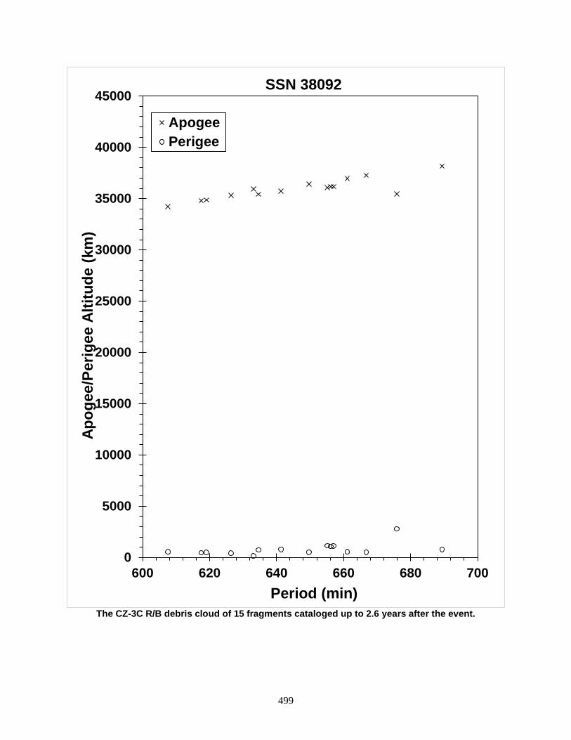
499
The CZ-3C R/B debris cloud of 15 fragments cataloged up to 2.6 years after the event.
0
5000
10000
15000
20000
25000
30000
35000
40000
45000
600 620 640 660 680 700
Apog
ee/P
erig
ee A
ltitu
de (k
m)
Period (min)
SSN 38092
ApogeePerigee

500
NIMIQ 6 R/B 2012-026B 38343 SATELLITE DATA TYPE: Briz-M Upper Stage Core OWNER: CIS LAUNCH DATE: 17 May 2012 DRY MASS (KG): 1220 MAIN BODY: cylinder 2.49 m diameter x 2.65 m length MAJOR APPENDAGES: none ATTITUDE CONTROL: none at time of event ENERGY SOURCES: unknown EVENT DATA DATE: 23 Dec 2015 LOCATION: 11.9N, 178E (dsc) TIME: 1600 GMT ASSESSED CAUSE: Unknown ALTITUDE: 24,310 km PRE-EVENT ELEMENTS EPOCH: 15356.29062075 MEAN ANOMALY: 128.0880177 RIGHT ASCENSION: 68.3779 MEAN MOTION: 1.76901584 INCLINATION: 12.0183 MEAN MOTION DOT/2: -0.00000143 ECCENTRICITY: 0.4187335 MEAN MOTION DOT DOT/6: 0.00000 ARG. OF PERIGEE: 203.9714 BSTAR: 0.00000 DEBRIS CLOUD DATA MAXIMUM ∆P: 13.9 min MAXIMUM ∆I: 0.09 deg COMMENTS Eight debris (in addition to the parent object) have been officially cataloged. Debris in deep-space orbits are difficult for the SSN to track and catalog. Hundreds of additional fragments could be on-orbit. REFERENCE DOCUMENTS “Briz-M Core Stage Fragments in Elliptical Orbit”, The Orbital Debris Quarterly News, NASA JSC, April 2016. Available online at http://orbitaldebris.jsc.nasa.gov/newsletter/pdfs/ODQNv20i1-2.pdf.

501
The Briz-M debris cloud; debris cataloged approximately 39 days after the event.
502
TELKOM 3 / EXPRESS MD2 BRIZ-M R/B 2012-044C 38746 SATELLITE DATA TYPE: Rocket Body OWNER: CIS LAUNCH DATE: 6 August 2012 DRY MASS (KG): 2510 MAIN BODY: Cylinder + toroid; 4.1 m diameter x 2.65 m length MAJOR APPENDAGES: none ATTITUDE CONTROL: none at the time of the event ENERGY SOURCES: on-board propellants EVENT DATA DATE: 16 Oct 2012 LOCATION: 32.447N, 335.711E (asc) TIME: 1631 GMT ASSESSED CAUSE: Propulsion ALTITUDE: 273.061 km PRE-EVENT ELEMENTS EPOCH: 12289.67349823 MEAN ANOMALY: 259.1600 RIGHT ASCENSION: 103.4658 MEAN MOTION: 10.14046751 INCLINATION: 49.8913 MEAN MOTION DOT/2: 0.00003146 ECCENTRICITY: 0.2633226 MEAN MOTION DOT DOT/6: 0.0000019595 ARG. OF PERIGEE: 127.8077 BSTAR: 0.00011788 DEBRIS CLOUD DATA MAXIMUM ∆P: 38.9 min MAXIMUM ∆I: 0.8 deg COMMENTS The dry mass quoted above includes that of the Briz-M core stage and the toroidal Auxiliary Propulsion Tank (APT)—sometimes referred to as the Additional Fuel Tank (AFT); the malfunction stranding the stage in its elliptical orbit occurred prior to APT jettison. The event occurred almost 70 days after launch. An estimated 10 metric tons of propellant was aboard. REFERENCE DOCUMENT “Upper Stage Explosion Places LEO Satellites at Risk”, The Orbital Debris Quarterly News, NASA JSC, January 2013. Available online at http://orbitaldebris.jsc.nasa.gov/newsletter/pdfs/ODQNv17i1.pdf. “New Russian Launch Failure Raises Breakup Concern”, The Orbital Debris Quarterly News, NASA JSC, October 2012. Available online at http://orbitaldebris.jsc.nasa.gov/newsletter/pdfs/ODQNv16i4.pdf.
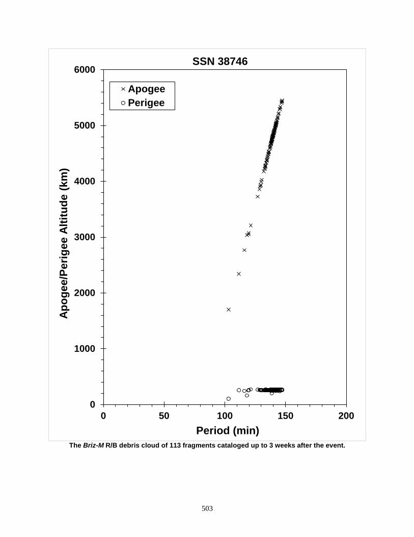
503
The Briz-M R/B debris cloud of 113 fragments cataloged up to 3 weeks after the event.
0
1000
2000
3000
4000
5000
6000
0 50 100 150 200
Apog
ee/P
erig
ee A
ltitu
de (k
m)
Period (min)
SSN 38746
ApogeePerigee
504
CASSIOPE R/B 2013-055G 39271 SATELLITE DATA TYPE: Rocket Body OWNER: USA LAUNCH DATE: 29 Sep 2013 DRY MASS (KG): 3900 kg MAIN BODY: cylinder; 3.66 m diameter x ~ 14 m length MAJOR APPENDAGES: none ATTITUDE CONTROL: active, 3 axis RCS ENERGY SOURCES: on-board propellants EVENT DATA DATE: 29 Sep 2013 LOCATION: 78.026S, 8.302E (asc) TIME: 1641 GMT ASSESSED CAUSE: Unknown ALTITUDE: 1204.12 km PRE-EVENT ELEMENTS EPOCH: 13272.73704787 MEAN ANOMALY: 327.9211 RIGHT ASCENSION: 315.1956 MEAN MOTION: 13.93734602 INCLINATION: 80.9876 MEAN MOTION DOT/2: 0.00000033 ECCENTRICITY: 0.0693087 MEAN MOTION DOT DOT/6: 0.0 ARG. OF PERIGEE: 153.5198 BSTAR: 0.0 (unavailable) DEBRIS CLOUD DATA MAXIMUM ∆P: 2.1 min MAXIMUM ∆I: 0.16 deg COMMENTS The elements listed above are from the first published TLE; the epoch time is approximately one hour and 21 seconds after the debris-producing event. This was the first flight of the Falcon 9 v1.1 second stage. The second stage engine restart, intended to cast the vehicle into its disposal orbit, failed. REFERENCE DOCUMENT “Upper Stage of New Falcon 9 Rocket Did Not Explode After Launch, SpaceX Says”, http://www.space.com/23038-spacex-falcon-9-rocket-explosion-rumors.html, retrieved 23 April 2015.
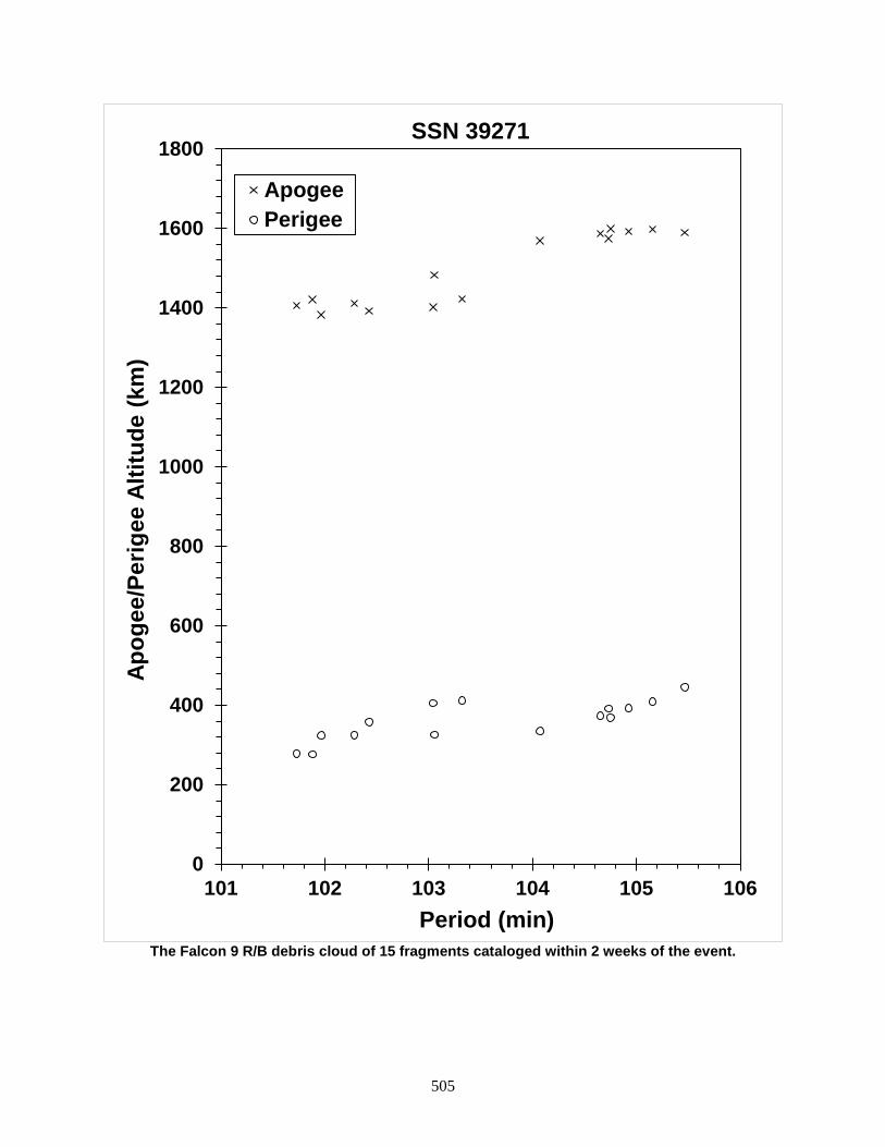
505
The Falcon 9 R/B debris cloud of 15 fragments cataloged within 2 weeks of the event.
0
200
400
600
800
1000
1200
1400
1600
1800
101 102 103 104 105 106
Apog
ee/P
erig
ee A
ltitu
de (k
m)
Period (min)
SSN 39271
ApogeePerigee
506
SENTINEL 1A 2014-016A 39634 SATELLITE DATA TYPE: payload OWNER: ESA LAUNCH DATE: 3 Apr 2014 DRY MASS (KG): 2170 MAIN BODY: cubical 3.9 m x 2.6 m x 2.5 m spacecraft envelope MAJOR APPENDAGES: dual solar arrays and synthetic aperture radar antenna ATTITUDE CONTROL: three-axis stabilized ENERGY SOURCES: monopropellant, batteries, gyroscope, reaction wheels EVENT DATA DATE: 23 Aug 2016 LOCATION: 72.03S, 39.59E (dsc) TIME: 1707 GMT ASSESSED CAUSE: Collision, accidental ALTITUDE: 723.20 km PRE-EVENT ELEMENTS EPOCH: 16235.56155967 MEAN ANOMALY: 283.0743 RIGHT ASCENSION: 241.4752 MEAN MOTION: 14.59198146 INCLINATION: 98.1816 MEAN MOTION DOT/2: +0.00000017 ECCENTRICITY: 0.0001365 MEAN MOTION DOT DOT/6: 0.00000 ARG. OF PERIGEE: 77.0610 BSTAR: +0.000013361 DEBRIS CLOUD DATA MAXIMUM ∆P: 2.9 min MAXIMUM ∆I: 0.1 deg COMMENTS This event is categorized as an accidental collision with a small particle. Normally, an event of this nature would have been categorized as an anomalous event; however, spacecraft attitude control was upset by the solar array impact and on-board cameras were able to document the before/after state of the penetrated solar array. While either small, un-cataloged debris or a micrometeoroid could have been this event’s projectile, the source of the resulting tracked and cataloged debris was unambiguous. REFERENCE DOCUMENT Collecte Localisation Satellites, “Sentinel-1A Debris Collision August 2016,” MPC-S1 (18 October 2016). Retrieved 28 September 2018 from https://sentinel.esa.int/documents/247904/2142675/Sentinel-1A_Debris_Collision_August_2016_MPC.pdf.

507
The Sentinel 1A debris cloud; debris cataloged within approximately 18 days of the event.
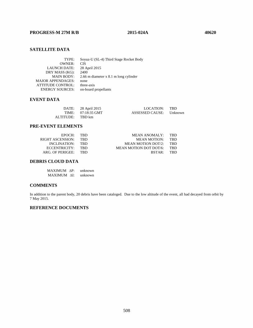
508
PROGRESS-M 27M R/B 2015-024A 40620 SATELLITE DATA TYPE: Soyuz-U (SL-4) Third Stage Rocket Body OWNER: CIS LAUNCH DATE: 28 April 2015 DRY MASS (KG): 2400 MAIN BODY: 2.66 m diameter x 8.1 m long cylinder MAJOR APPENDAGES: none ATTITUDE CONTROL: three-axis ENERGY SOURCES: on-board propellants EVENT DATA DATE: 28 April 2015 LOCATION: TBD TIME: 07:18:35 GMT ASSESSED CAUSE: Unknown ALTITUDE: TBD km PRE-EVENT ELEMENTS EPOCH: TBD MEAN ANOMALY: TBD RIGHT ASCENSION: TBD MEAN MOTION: TBD INCLINATION: TBD MEAN MOTION DOT/2: TBD ECCENTRICITY: TBD MEAN MOTION DOT DOT/6: TBD ARG. OF PERIGEE: TBD BSTAR: TBD DEBRIS CLOUD DATA MAXIMUM ∆P: unknown MAXIMUM ∆I: unknown COMMENTS In addition to the parent body, 20 debris have been cataloged. Due to the low altitude of the event, all had decayed from orbit by 7 May 2015. REFERENCE DOCUMENTS
509
The SL-4 R/B debris cloud cataloged between 28 April and 1 May 2015.
0
50
100
150
200
250
300
350
400
87 88 89 90 91
Apog
ee/P
erig
ee A
ltitu
de (k
m)
Period (min)
SSN 40620
ApogeePerigee
510
COSMOS 2513 R/B 2015-075B 41122 SATELLITE DATA TYPE: Briz-M Upper Stage Core OWNER: CIS LAUNCH DATE: 13 Dec 2015 DRY MASS (KG): 1220 MAIN BODY: cylinder 2.49 m diameter x 2.65 m long MAJOR APPENDAGES: none ATTITUDE CONTROL: none at time of event ENERGY SOURCES: unknown EVENT DATA DATE: 16 Jan 2016 LOCATION: 0.18S, 223.0E (dsc) TIME: 0350 GMT ASSESSED CAUSE: Unknown ALTITUDE: 34,880.09 km PRE-EVENT ELEMENTS EPOCH: 16015.10700804 MEAN ANOMALY: 221.1059 RIGHT ASCENSION: 135.1430 MEAN MOTION: 1.04652118 INCLINATION: 0.1737 MEAN MOTION DOT/2: -0.00000109 ECCENTRICITY: 0.0286832 MEAN MOTION DOT DOT/6: 0.00000 ARG. OF PERIGEE: 5.8561 BSTAR: 0.00000 DEBRIS CLOUD DATA MAXIMUM ∆P: 33.1 min MAXIMUM ∆I: 0.7 deg COMMENTS Seven debris (including the parent object) have been officially cataloged. Debris in deep-space orbits are difficult for the SSN to track and catalog. Hundreds of additional fragments could be on-orbit. REFERENCE DOCUMENTS “Briz-M Core Stage Fragments Near Geosynchronous Orbit”, The Orbital Debris Quarterly News, NASA JSC, April 2016. Available online at https://orbitaldebris.jsc.nasa.gov/quarterly-news/pdfs/odqnv20i1-2.pdf.
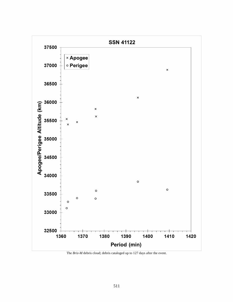
511
The Briz-M debris cloud; debris cataloged up to 127 days after the event.

512
ASTRO H (HITOMI) 2016-012A 41337 SATELLITE DATA TYPE: payload OWNER: Japan LAUNCH DATE: 17 Feb 2016 DRY MASS (KG): < 2700 MAIN BODY: cylinder 1.8 m diameter x 7.9 m long (13.6 m length overall after EOB erection) MAJOR APPENDAGES: Solar Array Paddles (SAP) and Extensible Optical Bench (EOB) ATTITUDE CONTROL: three-axis stabilized ENERGY SOURCES: propellant, batteries, reaction wheels EVENT DATA DATE: 26 Mar 2016 LOCATION: 20.82N, 267.36E (asc) TIME: 0142 GMT ASSESSED CAUSE: Propulsion ALTITUDE: 573.92 km PRE-EVENT ELEMENTS EPOCH: 16084.46380907 MEAN ANOMALY: 86.8693 RIGHT ASCENSION: 87.9716 MEAN MOTION: 14.98194942 INCLINATION: 31.0065 MEAN MOTION DOT/2: +0.00001057 ECCENTRICITY: 0.0011434 MEAN MOTION DOT DOT/6: 0.00000 ARG. OF PERIGEE: 273.0633 BSTAR: +0.00008 DEBRIS CLOUD DATA MAXIMUM ∆P: 0.47 min MAXIMUM ∆I: 0.02 deg COMMENTS This event is categorized as a propulsion-induced structural failure. REFERENCE DOCUMENTS “ASTRO-H Spacecraft Fragments During Payload Check-out Operations”, The Orbital Debris Quarterly News, NASA JSC, October 2016. Available online at https://www.orbitaldebris.jsc.nasa.gov/quarterly-news/pdfs/odqnv20i4.pdf. JAXA, “Hitomi Experience Report: Investigation of Anomalies Affecting the X-ray Astronomy Satellite ‘Hitomi’ (ASTRO-H),” 8 June 2016 edition. Retrieved 1 October 2016 from http://global.jaxa.jp/projects/sat/astro_h/topics.html?utm_source=dlvr.it&utm_medium=twitter#topics7815

513
The Hitomi debris cloud; debris cataloged up to approximately one year after the event.
520
530
540
550
560
570
580
590
95.4 95.6 95.8 96 96.2
Apog
ee/P
erig
ee A
ltitu
de (k
m)
Period (min)
SSN 41337
ApogeePerigee

514
FREGAT DEB (TANK) 2017-086C 43089 SATELLITE DATA TYPE: Mission Related Debris OWNER: CIS LAUNCH DATE: 26 Dec 2017 DRY MASS (KG): 375 MAIN BODY: toroidal fuel tank; 0.821 m tank diameter x 3.44 m overall diameter MAJOR APPENDAGES: none ATTITUDE CONTROL: none ENERGY SOURCES: unknown EVENT DATA DATE: 12 Feb 2018 LOCATION: 38.06N, 117.94E (asc) TIME: 0957 GMT ASSESSED CAUSE: unknown ALTITUDE: 396.48 km PRE-EVENT ELEMENTS EPOCH: 18041.75579119 MEAN ANOMALY: 287.5127 RIGHT ASCENSION: 273.8260 MEAN MOTION: 10.99960807 INCLINATION: 50.4229 MEAN MOTION DOT/2: 0.00005800 ECCENTRICITY: 0.2212829 MEAN MOTION DOT DOT/6: 0.0000034339 ARG. OF PERIGEE: 98.0587 BSTAR: 0.00020634 DEBRIS CLOUD DATA MAXIMUM ∆P: 26.3 min MAXIMUM ∆I: 0.3 deg COMMENTS The parent body is assumed to be the jettisonable auxiliary fuel tank discarded by the Fregat-SB upper stage. REFERENCE DOCUMENT “Fragmentation of Fregat-SB Upper Stage Debris”, The Orbital Debris Quarterly News, NASA JSC, May 2018. Available online at https://www.orbitaldebris.jsc.nasa.gov/quarterly-news/pdfs/odqnv22i2.pdf.

515
The Fregat-SB Auxiliary Propellant Tank debris cloud, composed of parent body and four fragments; debris cataloged up to 11
days after the event.

516
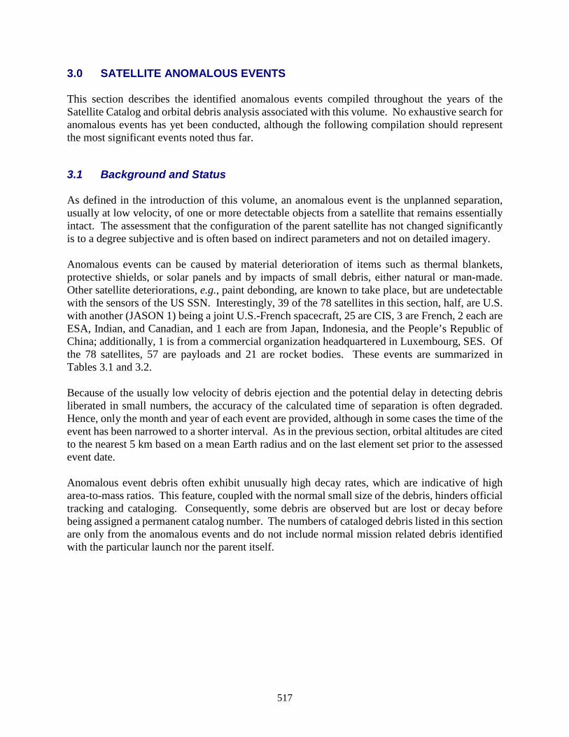
517
3.0 SATELLITE ANOMALOUS EVENTS This section describes the identified anomalous events compiled throughout the years of the Satellite Catalog and orbital debris analysis associated with this volume. No exhaustive search for anomalous events has yet been conducted, although the following compilation should represent the most significant events noted thus far.
3.1 Background and Status As defined in the introduction of this volume, an anomalous event is the unplanned separation, usually at low velocity, of one or more detectable objects from a satellite that remains essentially intact. The assessment that the configuration of the parent satellite has not changed significantly is to a degree subjective and is often based on indirect parameters and not on detailed imagery. Anomalous events can be caused by material deterioration of items such as thermal blankets, protective shields, or solar panels and by impacts of small debris, either natural or man-made. Other satellite deteriorations, e.g., paint debonding, are known to take place, but are undetectable with the sensors of the US SSN. Interestingly, 39 of the 78 satellites in this section, half, are U.S. with another (JASON 1) being a joint U.S.-French spacecraft, 25 are CIS, 3 are French, 2 each are ESA, Indian, and Canadian, and 1 each are from Japan, Indonesia, and the People’s Republic of China; additionally, 1 is from a commercial organization headquartered in Luxembourg, SES. Of the 78 satellites, 57 are payloads and 21 are rocket bodies. These events are summarized in Tables 3.1 and 3.2. Because of the usually low velocity of debris ejection and the potential delay in detecting debris liberated in small numbers, the accuracy of the calculated time of separation is often degraded. Hence, only the month and year of each event are provided, although in some cases the time of the event has been narrowed to a shorter interval. As in the previous section, orbital altitudes are cited to the nearest 5 km based on a mean Earth radius and on the last element set prior to the assessed event date. Anomalous event debris often exhibit unusually high decay rates, which are indicative of high area-to-mass ratios. This feature, coupled with the normal small size of the debris, hinders official tracking and cataloging. Consequently, some debris are observed but are lost or decay before being assigned a permanent catalog number. The numbers of cataloged debris listed in this section are only from the anomalous events and do not include normal mission related debris identified with the particular launch nor the parent itself.

518
Historically, anomalous events have often been confused with satellite breakups and have not been the subject of separate, extensive analyses. The list of events in this section is known to be incomplete. Several other satellites have been tentatively tagged as sources of anomalous events. Moreover, preliminary satellite catalog surveys suggest that additional anomalous events have occurred but remain unrecognized as such. Table 3.2 suggests a potential correlation of anomalous events with high solar activity. This section will be updated as future studies warrant. For additional information on anomalous events, see “Environmentally induced Debris Sources,” N. L. Johnson, Second World Space Congress, October 2002.
3.2 Identified Satellite Anomalous Events Much like section 2.2 above, this section identifies particulars for the limited number of anomalous events thus far cataloged. There is no Gabbard Diagram included with these events, and each page often refers to multiple events. The first known date of the first anomalous event is categorized for each satellite. Where possible the best estimate of the cause and potential failure are noted in the comments section.

TABLE 3.1 HISTORY OF SATELLITE ANOMALOUS EVENTS BY LAUNCH DATE
519
SATELLITE NAME
INTERNATIONAL DESIGNATOR
US SATELLITE NUMBER
LAUNCH DATE
FIRST EVENT DATE
KNOWN EVENTS
CATALOGED DEBRIS
ON-ORBIT DEBRIS
APOGEE (KM)
PERIGEE (KM)
INCLINATION (DEG)
VANGUARD 3 1959-007A 20 18-Sep-59 14-Feb-06 1 2 0 3310 510 33.4
TRANSIT 5B-2 1963-049B 704 5-Dec-63 9/10-Jan-98 1 2 2 1110 1060 90.1
ELEKTRON 1 1963-006A 746 30-Jan-64 prior to 1-Jan-80 1 24 1 6900 416 60.9
OPS 4412 (TRANSIT 9) 1964-026A 801 4-Jun-64 Dec-80 4 4 0 930 845 90.5
COSMOS 44 R/B 1964-053B 877 28-Aug-64 Nov-90 1 1 1 775 655 65.1
OPS 4988 (GREB 6) 1965-016A 1271 9-Mar-65 Nov-80 1 1 1 935 900 70.1
OPS 4682 (SNAPSHOT) 1965-027A 1314 3-Apr-65 1-Nov-79 7 158 158 1320 1270 90.3
OPS 8480 (TRANSIT 5B-6) 1965-048A 1420 24-Jun-65 Aug-80 4 9 0 1135 1025 89.9
ALOUETTE 2 1965-098A 1804 29-Nov-65 Aug-90 2 2 0 2705 505 79.8
FR-1 R/B 1965-101B 1815 6-Dec-65 21-Mar-03 1 2 0 660 655 75.8
OPS 1509 (TRANSIT 10) 1965-109A 1864 22-Dec-65 30-Nov-96 2 2 1 1065 895 89.1
OPS 1593 (TRANSIT 11) 1966-005A 1952 28-Jan-66 Apr-80 4 7 1 1205 855 89.8
OPS 1117 (TRANSIT 12) 1966-024A 2119 26-Mar-66 Jul-81 1 3 2 1115 890 89.9
NIMBUS 2 1966-040A 2173 15-May-66 Nov-97 Many 66 66 1175 1095 100.4
OPS 0856 1966-077A 2403 19-Aug-66 Mar-91 5 25 25 3710 3660 89.7
OPS 0100 (TRANSIT 15) 1967-034A 2754 14-Apr-67 Sep-92 1 5 4 1065 1035 90.1
OPS 7218 (TRANSIT 16) 1967-048A 2807 18-May-67 Feb-95 1 4 2 1090 1060 89.6
OPS 4947 (TRANSIT 17) 1967-092A 2965 25-Sep-67 Apr-81 4 7 0 1110 1035 89.3
COSMOS 206 R/B 1968-019B 3151 14-Mar-68 Nov-90 1 0 0 515 450 81.2
ISIS 1 1969-009A 3669 30-Jan-69 24-May-07 1 2 2 3455 580 88.5
TRANSIT 19 1970-067A 4507 27-Aug-70 7-Mar-98 1 1 0 1205 945 90.0
METEOR 1-7 R/B 1971-003B 4850 20-Jan-71 Jun-87 1 1 0 665 535 81.2
METEOR 1-12 R/B 1972-049B 6080 30-Jun-72 Sep-89 1 1 1 935 860 81.2
COSMOS 539 1972-102A 6319 21-Dec-72 21-Apr-02 1 1 0 1380 1340 74.0
GEOS 3 R/B 1975-027B 7735 9-Apr-75 Mar-78 1 3 2 845 835 115.0
KYOKKOH 1 (EXOS-A) 1978-014A 10664 4-Feb-78 Jan-88 2 2 0 4220 760 65.0
SEASAT 1978-064A 10967 27-Jun-78 Jul-83 >12 18 1 780 780 108.0
COSMOS 1043 1978-094A 11055 10-Oct-78 Feb-93 1 1 0 435 435 81.2
TIROS-N 1978-096A 11060 13-Oct-78 Sep-87 2 5 0 855 835 99.0
NIMBUS 7 R/B 1978-098B 11081 24-Oct-78 May-81 2 1 0 955 935 99.3
NOAA 6 1979-057A 11416 27-Jun-79 Sep-92 2 3 1 805 790 98.7
METEOR 2-5 1979-095A 11605 31-Oct-79 prior to 1-Jan-05 Multiple 83 60 881 862 81.2
METEOR 2-7 1981-043A 12456 14-May-81 Mar-04 1 20 15 895 825 81.3
METEOR 2-7 R/B 1981-043B 12457 14-May-81 Oct-96 1 1 1 920 825 81.3

TABLE 3.1 HISTORY OF SATELLITE ANOMALOUS EVENTS BY LAUNCH DATE (CONT’D)
520
SATELLITE NAME
INTERNATIONAL DESIGNATOR
US SATELLITE NUMBER
LAUNCH DATE
FIRST EVENT DATE
KNOWN EVENTS
CATALOGED DEBRIS
ON-ORBIT DEBRIS
APOGEE (KM)
PERIGEE (KM)
INCLINATION (DEG)
MOLNIYA 3-16 R/B 1981-054E 12519 9-Jun-81 Jul-98 1 0 0 33415 85 62.0
NOAA 7 1981-059A 12553 23-Jun-81 26-Jul-93 2 6 1 835 830 98.9
COSMOS 1417 R/B 1982-102B 13618 19-Oct-82 Early-09 1 1 1 1000 955 83.0
NOAA 8 1983-022A 13923 28-Mar-83 Early-05 2 4 3 810 790 98.7
OSCAR 30 1985-066A 15935 3-Aug-85 Nov-86 2 2 2 1255 1000 89.9
COSMOS 1689 R/B 1985-090B 16111 3-Oct-85 5-May-02 1 1 1 565 510 97.7
NOAA 10 1986-073A 16969 17-Sep-86 Jun-07 2 4 1 810 790 98.7
COSMOS 1818 1987-011A 17369 1-Feb-87 4-Jul-08 1 0 0 800 775 65.0
COSMOS 1823 1987-020A 17535 20-Feb-87 Apr-May 97 3 3 3 1525 1480 73.6
COSMOS 1867 1987-060A 18187 10-Jul-87 21-Mar to 4-Apr-14 1 0 0 800 775 65.0
METEOR 2-17 1988-005A 18820 30-Jan-88 2000-2001 2 0 0 960 936 82.5
COSMOS 1939 R/B 1988-032B 19046 20-Apr-88 30-Jul-96 2 2 2 655 585 97.6
NOAA 11 1988-089A 19531 24-Sep-88 24-Nov-10 1 2 2 850 835 98.8
COBE 1989-089A 20322 18-Nov-89 Mar-93 12 78 2 885 870 99.0
NADEZHDA 2 R/B 1990-017B 20509 27-Feb-90 22-Jun-05 1 1 1 1015 950 83.0
HST 1990-037B 20580 24-Apr-90 5-Aug-03 1 1 0 575 570 28.5
NOAA 12 1991-032A 21263 14-May-91 2-Oct-11 1 4 4 815 800 98.7
OKEAN 3 1991-039A 21397 4-Jun-91 12-Oct-98 1 1 0 655 620 82.5
ERS-1 1991-050A 21574 17-Jul-91 7-Jul-02 7 7 7 800 750 98.5
SARA 1991-050E 21578 17-Jul-91 22-Aug-03 3 4 0 730 730 98.1
ERS-1 R/B 1991-050F 21610 17-Jul-91 Apr-01 1 1 0 770 770 98.2
UARS 1991-063B 21701 12-Sep-91 10-Nov-07 3 5 0 485 355 57.0
EKA 1 (START 1) 1993-014A 22561 25-Mar-93 4-Mar-98 1 2 2 970 685 75.8
START 1 R/B 1993-014B 22562 25-Mar-93 Late-02 Multiple 56 22 920 680 75.8
USA 106 (DMSP 5D-2 F12) 1994-057A 23233 29-Aug-94 23-Oct-16 1 4 4 848 832 99.1
COSMOS 2297 R/B 1994-077B 23405 24-Nov-94 Jun-98 2? 1 0 845 845 71.0
NOAA 14 1994-089A 23455 30-Dec-94 Jul-12 1 1 1 860 850 98.8
ERS-2 1995-021A 23560 21-Apr-95 24-Jul-03 Multiple 6 5 787 785 98.6
ERS-2 R/B 1995-021B 23561 21-Apr-95 prior to 1-Jan-18 1 1 1 772 762 98.8
KOREASAT 1 R/B 1995-041B 23640 5-Aug-95 6-Dec-95 1 1 0 1375 935 26.7
RADARSAT R/B 1995-059B 23711 4-Nov-95 30-Jan-96 1 2 0 1495 935 100.6
IRS B3 1996-017A 23827 21-Mar-96 Oct-00 1 1 0 822 820 98.6
IRIDIUM 47 1997-082C 25106 20-Dec-97 7-Jun-14 1 10 7 781 778 86.4
FUSE 1999-035A 25791 24-Jun-99 6-Jun-04 1 9 0 760 745 25.0
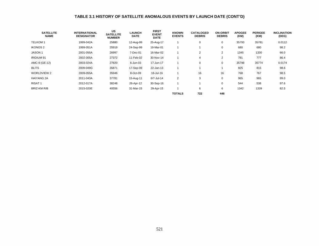
TABLE 3.1 HISTORY OF SATELLITE ANOMALOUS EVENTS BY LAUNCH DATE (CONT’D)
521
SATELLITE NAME
INTERNATIONAL DESIGNATOR
US SATELLITE NUMBER
LAUNCH DATE
FIRST EVENT DATE
KNOWN EVENTS
CATALOGED DEBRIS
ON-ORBIT DEBRIS
APOGEE (KM)
PERIGEE (KM)
INCLINATION (DEG)
TELKOM 1 1999-042A 25880 12-Aug-99 25-Aug-17 1 0 0 35793 35781 0.0112
IKONOS 2 1999-051A 25919 24-Sep-99 19-Mar-01 1 1 0 680 680 98.2
JASON 1 2001-055A 26997 7-Dec-01 16-Mar-02 1 2 2 1345 1330 66.0
IRIDIUM 91 2002-005A 27372 11-Feb-02 30-Nov-14 1 4 2 781 777 86.4
AMC-9 (GE-12) 2003-024A 27820 6-Jun-03 17-Jun-17 1 0 0 35798 35774 0.0174
BLITS 2009-049G 35871 17-Sep-09 22-Jan-13 1 1 1 825 815 98.6
WORLDVIEW 2 2009-055A 35946 8-Oct-09 18-Jul-16 1 16 16 768 767 98.5
HAIYANG 2A 2011-043A 37781 15-Aug-11 6/7-Jul-14 2 3 0 965 965 99.0
RISAT 1 2012-017A 38248 26-Apr-12 30-Sep-16 1 1 0 544 538 97.6
BRIZ-KM R/B 2015-020E 40556 31-Mar-15 29-Apr-15 1 6 6 1342 1339 82.5 TOTALS 722 446
TABLE 3.2 HISTORY OF SATELLITE ANOMALOUS EVENTS BY EVENT DATE
522
SATELLITE NAME
INTERNATIONAL DESIGNATOR
US SATELLITE NUMBER
LAUNCH DATE
FIRST EVENT DATE
KNOWN EVENTS
CATALOGED DEBRIS
ON-ORBIT DEBRIS
APOGEE (KM)
PERIGEE (KM)
INCLINATION (DEG)
GEOS 3 R/B 1975-027B 7735 9-Apr-75 Mar-78 1 3 2 845 835 115.0
OPS 4682 (SNAPSHOT) 1965-027A 1314 3-Apr-65 1-Nov-79 7 158 158 1320 1270 90.3
ELEKTRON 1 1963-006A 746 30-Jan-64 prior to 1-Jan-80 1 24 1 6900 416 60.9
OPS 1593 (TRANSIT 11) 1966-005A 1952 28-Jan-66 Apr-80 4 7 1 1205 855 89.8
OPS 8480 (TRANSIT 5B-6) 1965-048A 1420 24-Jun-65 Aug-80 4 9 0 1135 1025 89.9
OPS 4988 (GREB 6) 1965-016A 1271 9-Mar-65 Nov-80 1 1 1 935 900 70.1
OPS 4412 (TRANSIT 9) 1964-026A 801 4-Jun-64 Dec-80 4 4 0 930 845 90.5
OPS 4947 (TRANSIT 17) 1967-092A 2965 25-Sep-67 Apr-81 4 7 0 1110 1035 89.3
NIMBUS 7 R/B 1978-098B 11081 24-Oct-78 May-81 2 1 0 955 935 99.3
OPS 1117 (TRANSIT 12) 1966-024A 2119 26-Mar-66 Jul-81 1 3 2 1115 890 89.9
SEASAT 1978-064A 10967 27-Jun-78 Jul-83 >12 18 1 780 780 108.0
OSCAR 30 1985-066A 15935 3-Aug-85 Nov-86 2 2 2 1255 1000 89.9
METEOR 1-7 R/B 1971-003B 4850 20-Jan-71 Jun-87 1 1 0 665 535 81.2
TIROS-N 1978-096A 11060 13-Oct-78 Sep-87 2 5 0 855 835 99.0
KYOKKOH 1 (EXOS-A) 1978-014A 10664 4-Feb-78 Jan-88 2 2 0 4220 760 65.0
METEOR 1-12 R/B 1972-049B 6080 30-Jun-72 Sep-89 1 1 1 935 860 81.2
ALOUETTE 2 1965-098A 1804 29-Nov-65 Aug-90 2 2 0 2705 505 79.8
COSMOS 44 R/B 1964-053B 877 28-Aug-64 Nov-90 1 1 1 775 655 65.1
COSMOS 206 R/B 1968-019B 3151 14-Mar-68 Nov-90 1 0 0 515 450 81.2
OPS 0856 1966-077A 2403 19-Aug-66 Mar-91 5 25 25 3710 3660 89.7
OPS 0100 (TRANSIT 15) 1967-034A 2754 14-Apr-67 Sep-92 1 5 4 1065 1035 90.1
NOAA 6 1979-057A 11416 27-Jun-79 Sep-92 2 3 1 805 790 98.7
COSMOS 1043 1978-094A 11055 10-Oct-78 Feb-93 1 1 0 435 435 81.2
COBE 1989-089A 20322 18-Nov-89 Mar-93 12 78 2 885 870 99.0
NOAA 7 1981-059A 12553 23-Jun-81 26-Jul-93 2 6 1 835 830 98.9
OPS 7218 (TRANSIT 16) 1967-048A 2807 18-May-67 Feb-95 1 4 2 1090 1060 89.6
KOREASAT 1 R/B 1995-041B 23640 5-Aug-95 6-Dec-95 1 1 0 1375 935 26.7
RADARSAT R/B 1995-059B 23711 4-Nov-95 30-Jan-96 1 2 0 1495 935 100.6
COSMOS 1939 R/B 1988-032B 19046 20-Apr-88 30-Jul-96 2 2 2 655 585 97.6
METEOR 2-7 R/B 1981-043B 12457 14-May-81 Oct-96 1 1 1 920 825 81.3
OPS 1509 (TRANSIT 10) 1965-109A 1864 22-Dec-65 30-Nov-96 2 2 1 1065 895 89.1
COSMOS 1823 1987-020A 17535 20-Feb-87 Apr-May 97 3 3 3 1525 1480 73.6
NIMBUS 2 1966-040A 2173 15-May-66 Nov-97 Many 66 66 1175 1095 100.4
TRANSIT 5B-2 1963-049B 704 5-Dec-63 9/10-Jan-98 1 2 2 1110 1060 90.1

TABLE 3.2 HISTORY OF SATELLITE ANOMALOUS EVENTS BY EVENT DATE (CONT’D)
523
SATELLITE NAME
INTERNATIONAL DESIGNATOR
US SATELLITE NUMBER
LAUNCH DATE
FIRST EVENT DATE
KNOWN EVENTS
CATALOGED DEBRIS
ON-ORBIT DEBRIS
APOGEE (KM)
PERIGEE (KM)
INCLINATION (DEG)
EKA 1 (START 1) 1993-014A 22561 25-Mar-93 4-Mar-98 1 2 2 970 685 75.8
TRANSIT 19 1970-067A 4507 27-Aug-70 7-Mar-98 1 1 0 1205 945 90.0
COSMOS 2297 R/B 1994-077B 23405 24-Nov-94 Jun-98 2? 1 0 845 845 71.0
MOLNIYA 3-16 R/B 1981-054E 12519 9-Jun-81 Jul-98 1 0 0 33415 85 62.0
OKEAN 3 1991-039A 21397 4-Jun-91 12-Oct-98 1 1 0 655 620 82.5
METEOR 2-17 1988-005A 18820 30-Jan-88 2000-2001 2 0 0 960 936 82.5
IRS B3 1996-017A 23827 21-Mar-96 Oct-00 1 1 0 822 820 98.6
IKONOS 2 1999-051A 25919 24-Sep-99 19-Mar-01 1 1 0 680 680 98.2
ERS-1 R/B 1991-050F 21610 17-Jul-91 Apr-01 1 1 0 770 770 98.2
JASON 1 2001-055A 26997 7-Dec-01 16-Mar-02 1 2 2 1345 1330 66.0
COSMOS 539 1972-102A 6319 21-Dec-72 21-Apr-02 1 1 0 1380 1340 74.0
COSMOS 1689 R/B 1985-090B 16111 3-Oct-85 5-May-02 1 1 1 565 510 97.7
ERS-1 1991-050A 21574 17-Jul-91 7-Jul-02 7 7 7 800 750 98.5
START 1 R/B 1993-014B 22562 25-Mar-93 Late-02 Multiple 56 22 920 680 75.8
FR-1 R/B 1965-101B 1815 6-Dec-65 21-Mar-03 1 2 0 660 655 75.8
ERS-2 1995-021A 23560 21-Apr-95 24-Jul-03 Multiple 6 5 787 785 98.6
HST 1990-037B 20580 24-Apr-90 5-Aug-03 1 1 0 575 570 28.5
SARA 1991-050E 21578 17-Jul-91 22-Aug-03 3 4 0 730 730 98.1
METEOR 2-7 1981-043A 12456 14-May-81 Mar-04 1 20 15 895 825 81.3
FUSE 1999-035A 25791 24-Jun-99 6-Jun-04 1 9 0 760 745 25.0
METEOR 2-5 1979-095A 11605 31-Oct-79 prior to 1-Jan-05 Multiple 83 60 881 862 81.2
NOAA 8 1983-022A 13923 28-Mar-83 Early-05 2 4 3 810 790 98.7
NADEZHDA 2 R/B 1990-017B 20509 27-Feb-90 22-Jun-05 1 1 1 1015 950 83.0
VANGUARD 3 1959-007A 20 18-Sep-59 14-Feb-06 1 2 0 3310 510 33.4
ISIS 1 1969-009A 3669 30-Jan-69 24-May-07 1 2 2 3455 580 88.5
NOAA 10 1986-073A 16969 17-Sep-86 Jun-07 2 4 1 810 790 98.7
UARS 1991-063B 21701 12-Sep-91 10-Nov-07 3 5 0 485 355 57.0
COSMOS 1818 1987-011A 17369 1-Feb-87 4-Jul-08 1 0 0 800 775 65.0
COSMOS 1417 R/B 1982-102B 13618 19-Oct-82 Early-09 1 1 1 1000 955 83.0
NOAA 11 1988-089A 19531 24-Sep-88 24-Nov-10 1 2 2 850 835 98.8
NOAA 12 1991-032A 21263 14-May-91 2-Oct-11 1 4 4 815 800 98.7
NOAA 14 1994-089A 23455 30-Dec-94 Jul-12 1 1 1 860 850 98.8
BLITS 2009-049G 35871 17-Sep-09 22-Jan-13 1 1 1 825 815 98.6
COSMOS 1867 1987-060A 18187 10-Jul-87 21-Mar to 4-Apr-14 1 0 0 800 775 65.0

TABLE 3.2 HISTORY OF SATELLITE ANOMALOUS EVENTS BY EVENT DATE (CONT’D)
524
SATELLITE NAME
INTERNATIONAL DESIGNATOR
US SATELLITE NUMBER
LAUNCH DATE
FIRST EVENT DATE
KNOWN EVENTS
CATALOGED DEBRIS
ON-ORBIT DEBRIS
APOGEE (KM)
PERIGEE (KM)
INCLINATION (DEG)
IRIDIUM 47 1997-082C 25106 20-Dec-97 7-Jun-14 1 10 7 781 778 86.4
HAIYANG 2A 2011-043A 37781 15-Aug-11 6/7-Jul-14 2 3 0 965 965 99.0
IRIDIUM 91 2002-005A 27372 11-Feb-02 30-Nov-14 1 4 2 781 777 86.4
BRIZ-KM R/B 2015-020E 40556 31-Mar-15 29-Apr-15 1 6 6 1342 1339 82.5
WORLDVIEW 2 2009-055A 35946 8-Oct-09 18-Jul-16 1 16 16 768 767 98.5
RISAT 1 2012-017A 38248 26-Apr-12 30-Sep-16 1 1 0 544 538 97.6
USA 106 (DMSP 5D-2 F12) 1994-057A 23233 29-Aug-94 23-Oct-16 1 4 4 848 832 99.1
AMC-9 (GE-12) 2003-024A 27820 6-Jun-03 17-Jun-17 1 0 0 35798 35774 0.0174
TELKOM 1 1999-042A 25880 12-Aug-99 25-Aug-17 1 0 0 35793 35781 0.0112
ERS-2 R/B 1995-021B 23561 21-Apr-95 prior to 1-Jan-18 1 1 1 772 762 98.8
TOTALS 722 446

525
VANGUARD 3 1959-007A 20 SATELLITE DATA TYPE: Payload OWNER: US LAUNCH DATE: 18 Sep 1959 DRY MASS (KG): 45 MAIN BODY: 50.8 cm sphere with third stage attached MAJOR APPENDAGES: 66 cm boom(s) ATTITUDE CONTROL: spin stabilized EVENT DATA KNOWN EVENTS: 1 FIRST DATE: 14 Feb 2006 APOGEE PERIGEE PERIOD INCLINATION 3310 510 125.14 min 33.4 deg COMMENTS At the time of the event, Vanguard 3 was the 5th oldest object in orbit. Two objects released, although the second object was not cataloged until May 2007. REFERENCE DOCUMENT “First Satellite Breakups of 2006”, The Orbital Debris Quarterly News, NASA JSC, July 2006. Available online at https://orbitaldebris.jsc.nasa.gov/quarterly-news/pdfs/ODQNv10i3.pdf. “Detection of Debris from Chinese ASAT Test Increases; One Minor Fragmentation Event in Second Quarter of 2007”, The Orbital Debris Quarterly News, NASA JSC, July 2007. Available online at https://orbitaldebris.jsc.nasa.gov/quarterly-news/pdfs/ODQNv11i3.pdf.
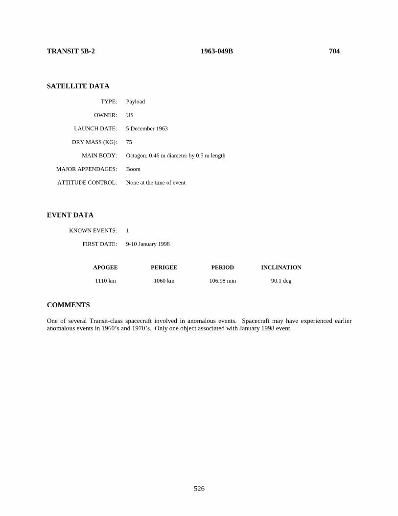
526
TRANSIT 5B-2 1963-049B 704 SATELLITE DATA TYPE: Payload OWNER: US LAUNCH DATE: 5 December 1963 DRY MASS (KG): 75 MAIN BODY: Octagon; 0.46 m diameter by 0.5 m length MAJOR APPENDAGES: Boom ATTITUDE CONTROL: None at the time of event EVENT DATA KNOWN EVENTS: 1 FIRST DATE: 9-10 January 1998 APOGEE PERIGEE PERIOD INCLINATION 1110 km 1060 km 106.98 min 90.1 deg COMMENTS One of several Transit-class spacecraft involved in anomalous events. Spacecraft may have experienced earlier anomalous events in 1960’s and 1970’s. Only one object associated with January 1998 event.

527
ELEKTRON 1 1964-006A 746 SATELLITE DATA TYPE: payload OWNER: CIS LAUNCH DATE: 30 Jan 1964 DRY MASS (KG): 329 MAIN BODY: Cylinder with hemispherical ends; 0.75 m diameter by 1.3 m length MAJOR APPENDAGES: Six solar arrays, antennas ATTITUDE CONTROL: None at the time of event EVENT DATA KNOWN EVENTS: 1 FIRST DATE: prior to 1 January 1980 APOGEE PERIGEE PERIOD INCLINATION 6900 km 416 km 166.8 min 60.9 deg COMMENTS “Event Data” is for epoch of 3 January 1980, given the uncertainty in actual time of separation event(s). It is likely that four of the 24 anomalous debris are associated with other space missions, including the sole piece on orbit as of this edition.

528
OPS 4412 (TRANSIT 9) 1964-026A 801 SATELLITE DATA TYPE: Payload OWNER: US LAUNCH DATE: 4 June 1964 DRY MASS (KG): 60 MAIN BODY: Octagonal cylinder; 0.5 m by 0.4 m MAJOR APPENDAGES: 4 solar panels; gravity-gradient boom ATTITUDE CONTROL: Gravity-gradient boom EVENT DATA KNOWN EVENTS: 4 FIRST DATE: December 1980 APOGEE PERIGEE PERIOD INCLINATION 930 km 845 km 102.7 min 90.5 deg COMMENTS Second event observed July 1982. The third event occurred in May 1994. Fourth event date not determined but also close to May 1994. First fragment decayed rapidly; the second decayed more slowly. Two latest pieces not cataloged as of publication date. One of several known Transits involved in anomalous events.
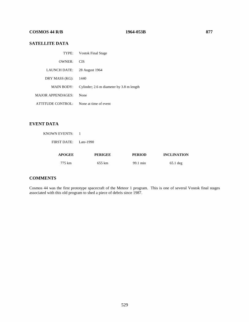
529
COSMOS 44 R/B 1964-053B 877 SATELLITE DATA TYPE: Vostok Final Stage OWNER: CIS LAUNCH DATE: 28 August 1964 DRY MASS (KG): 1440 MAIN BODY: Cylinder; 2.6 m diameter by 3.8 m length MAJOR APPENDAGES: None ATTITUDE CONTROL: None at time of event EVENT DATA KNOWN EVENTS: 1 FIRST DATE: Late-1990 APOGEE PERIGEE PERIOD INCLINATION 775 km 655 km 99.1 min 65.1 deg COMMENTS Cosmos 44 was the first prototype spacecraft of the Meteor 1 program. This is one of several Vostok final stages associated with this old program to shed a piece of debris since 1987.

530
OPS 4988 (GREB 6) 1965-016A 1271 SATELLITE DATA TYPE: Payload OWNER: US LAUNCH DATE: 9 May 1965 DRY MASS (KG): 40 MAIN BODY: Sphere MAJOR APPENDAGES: Unknown ATTITUDE CONTROL: Unknown EVENT DATA KNOWN EVENTS: 1 FIRST DATE: November 1980 APOGEE PERIGEE PERIOD INCLINATION 935 km 900 km 103.4 min 70.1 deg COMMENTS No other events observed.

531
OPS 4682 (SNAPSHOT) 1965-027A 1314 SATELLITE DATA TYPE: Payload (attached to Agena D upper stage) OWNER: US LAUNCH DATE: 3 April 1965 DRY MASS (KG): 2500 (approx.) MAIN BODY: Cylinder-cone; 1.5 m by 11.6 m MAJOR APPENDAGES: None ATTITUDE CONTROL: None at time of event EVENT DATA KNOWN EVENTS: 7 FIRST DATE: November 1979 APOGEE PERIGEE PERIOD INCLINATION 1320 km 1270 km 111.5 min 90.3 deg COMMENTS Six additional events observed: Dec 1980, Aug 1981, Mar 1983, Aug 1983, Nov 1983, and Jan 1985. Decay rates of all debris are nominal for this altitude. One debris was administratively decayed in February 1989. REFERENCE DOCUMENTS Investigation of Certain Anomalies Associated with Object 1314, A US Nuclear Powered Satellite, G. T. DeVere, Technical Memorandum 85-S-001, Headquarters NORAD/ADCOM, DCS/Plans, March 1985 (Appendix TM-85-001A, Secret). Environmentally-Induced Debris Sources, N. L. Johnson, NASA Lyndon B. Johnson Space Center, Second World Space Congress, 2002.

532
OPS 8480 (TRANSIT 5B-6) 1965-048A 1420 SATELLITE DATA TYPE: Payload OWNER: US LAUNCH DATE: 24 June 1965 DRY MASS (KG): 60 MAIN BODY: Octagonal cylinder; 0.5 m by 0.4 m MAJOR APPENDAGES: 4 solar panels; gravity-gradient boom ATTITUDE CONTROL: Gravity-gradient EVENT DATA KNOWN EVENTS: Multiple FIRST DATE: August 1980 APOGEE PERIGEE PERIOD INCLINATION 1135 km 1025 km 106.8 min 89.9 deg COMMENTS Three additional events observed: one 2 days after the initial event, one in June 1981, and the most recent in late 1999. All debris appear very small. One of several known Transits involved in anomalous events. REFERENCE DOCUMENT Environmentally-Induced Debris Sources, N. L. Johnson, NASA Lyndon B. Johnson Space Center, Second World Space Congress, 2002.
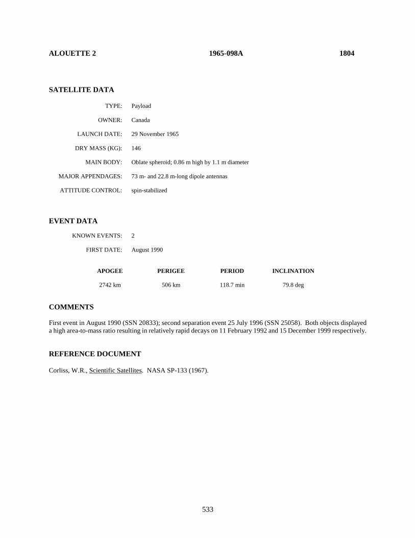
533
ALOUETTE 2 1965-098A 1804 SATELLITE DATA TYPE: Payload OWNER: Canada LAUNCH DATE: 29 November 1965 DRY MASS (KG): 146 MAIN BODY: Oblate spheroid; 0.86 m high by 1.1 m diameter MAJOR APPENDAGES: 73 m- and 22.8 m-long dipole antennas ATTITUDE CONTROL: spin-stabilized EVENT DATA KNOWN EVENTS: 2 FIRST DATE: August 1990 APOGEE PERIGEE PERIOD INCLINATION 2742 km 506 km 118.7 min 79.8 deg COMMENTS First event in August 1990 (SSN 20833); second separation event 25 July 1996 (SSN 25058). Both objects displayed a high area-to-mass ratio resulting in relatively rapid decays on 11 February 1992 and 15 December 1999 respectively. REFERENCE DOCUMENT Corliss, W.R., Scientific Satellites. NASA SP-133 (1967).
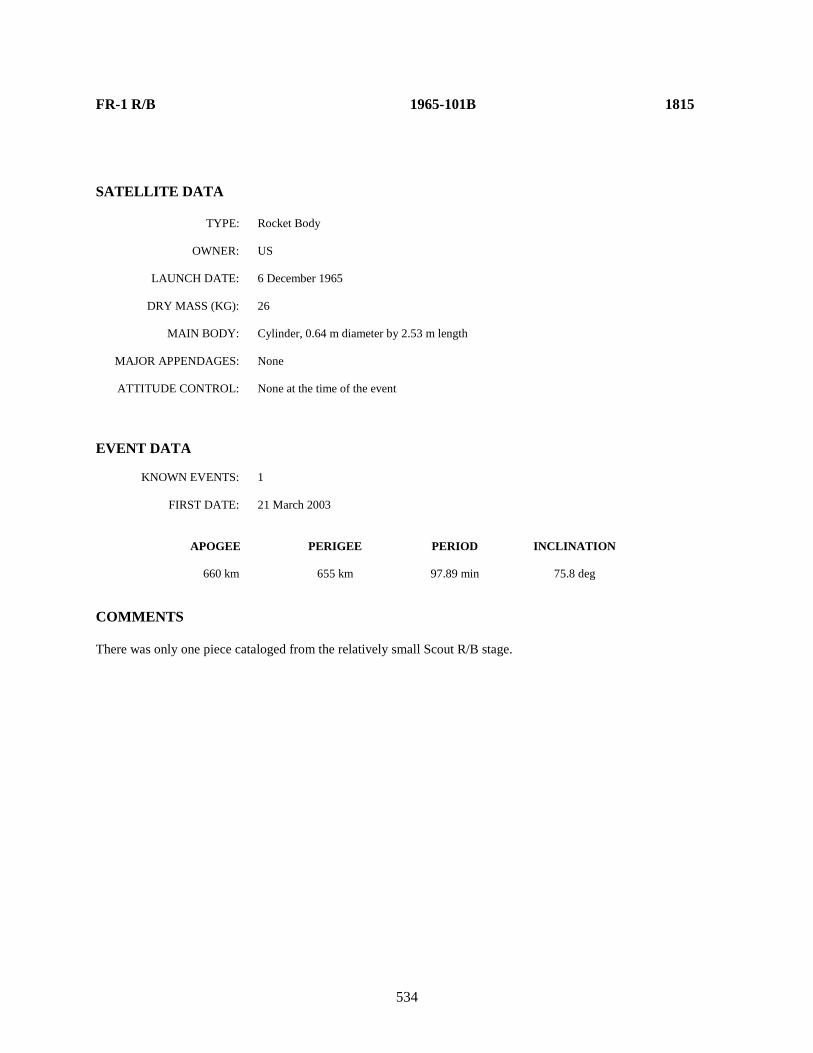
534
FR-1 R/B 1965-101B 1815
SATELLITE DATA TYPE: Rocket Body OWNER: US LAUNCH DATE: 6 December 1965 DRY MASS (KG): 26 MAIN BODY: Cylinder, 0.64 m diameter by 2.53 m length MAJOR APPENDAGES: None ATTITUDE CONTROL: None at the time of the event EVENT DATA KNOWN EVENTS: 1 FIRST DATE: 21 March 2003 APOGEE PERIGEE PERIOD INCLINATION 660 km 655 km 97.89 min 75.8 deg COMMENTS There was only one piece cataloged from the relatively small Scout R/B stage.
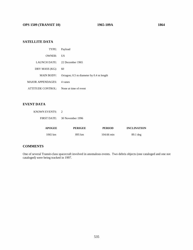
535
OPS 1509 (TRANSIT 10) 1965-109A 1864 SATELLITE DATA TYPE: Payload OWNER: US LAUNCH DATE: 22 December 1965 DRY MASS (KG): 60 MAIN BODY: Octagon; 0.5 m diameter by 0.4 m length MAJOR APPENDAGES: 4 vanes ATTITUDE CONTROL: None at time of event EVENT DATA KNOWN EVENTS: 2 FIRST DATE: 30 November 1996 APOGEE PERIGEE PERIOD INCLINATION 1065 km 895 km 104.66 min 89.1 deg COMMENTS One of several Transit-class spacecraft involved in anomalous events. Two debris objects (one cataloged and one not cataloged) were being tracked in 1997.

536
OPS 1593 (TRANSIT 11) 1966-005A 1952 SATELLITE DATA TYPE: Payload OWNER: US LAUNCH DATE: 28 January 1966 DRY MASS (KG): 60 MAIN BODY: Octagonal cylinder; 0.5 m by 0.4 m MAJOR APPENDAGES: 4 solar panels; gravity-gradient boom ATTITUDE CONTROL: Gravity-gradient EVENT DATA KNOWN EVENTS: 3 FIRST DATE: April 1980 APOGEE PERIGEE PERIOD INCLINATION 1205 km 855 km 105.8 min 89.8 deg COMMENTS Two additional events observed: Sep 1980 and Jul 1983. Last event may have originated with a piece of debris from earlier event. One of several known Transits involved in anomalous events.

537
OPS 1117 (TRANSIT 12) 1966-024A 2119 SATELLITE DATA TYPE: Payload OWNER: US LAUNCH DATE: 26 March 1966 DRY MASS (KG): 60 MAIN BODY: Octagonal cylinder; 0.5 m by 0.4 m MAJOR APPENDAGES: 4 solar panels; gravity-gradient boom ATTITUDE CONTROL: Gravity-gradient EVENT DATA KNOWN EVENTS: 1 FIRST DATE: July 1981 APOGEE PERIGEE PERIOD INCLINATION 1115 km 890 km 105.1 min 89.9 deg COMMENTS No other events observed. One of several known Transits involved in anomalous events.

538
NIMBUS 2 1966-040A 2173
SATELLITE DATA TYPE: Payload OWNER: US LAUNCH DATE: 15 May 1966 DRY MASS (KG): 414 MAIN BODY: Conical skeleton; 1.45 m diameter by 3.0 m length MAJOR APPENDAGES: 2 Paddles ATTITUDE CONTROL: None at time of event EVENT DATA KNOWN EVENTS: Multiple FIRST DATE: November 1997 APOGEE PERIGEE PERIOD INCLINATION 1175 km 1095 km 108.03 min 100.4 deg COMMENTS A single piece of debris was detected on 16 November 1997. Separation may have occurred about 1 November. Numerous debris were released from the late 1990’s to 2001. See cited reference below. REFERENCE DOCUMENT Environmentally-Induced Debris Sources, N. L. Johnson, NASA Lyndon B. Johnson Space Center, Second World Space Congress, 2002.
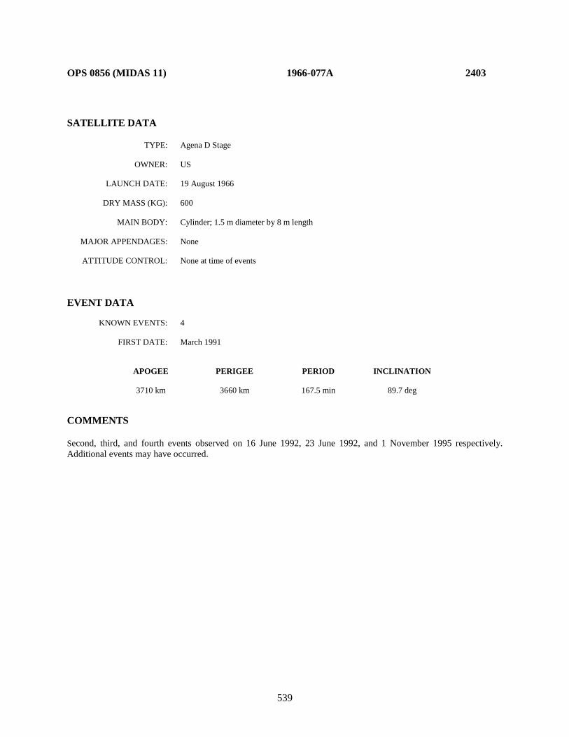
539
OPS 0856 (MIDAS 11) 1966-077A 2403 SATELLITE DATA TYPE: Agena D Stage OWNER: US LAUNCH DATE: 19 August 1966 DRY MASS (KG): 600 MAIN BODY: Cylinder; 1.5 m diameter by 8 m length MAJOR APPENDAGES: None ATTITUDE CONTROL: None at time of events EVENT DATA KNOWN EVENTS: 4 FIRST DATE: March 1991 APOGEE PERIGEE PERIOD INCLINATION 3710 km 3660 km 167.5 min 89.7 deg COMMENTS Second, third, and fourth events observed on 16 June 1992, 23 June 1992, and 1 November 1995 respectively. Additional events may have occurred.
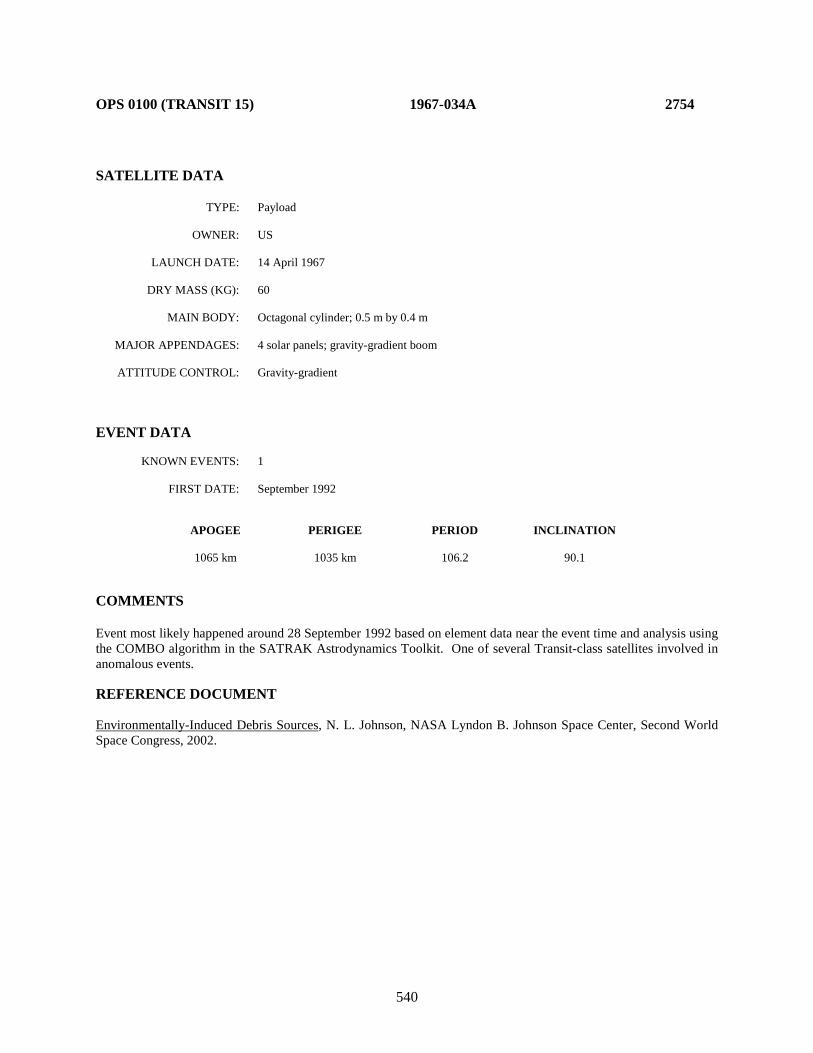
540
OPS 0100 (TRANSIT 15) 1967-034A 2754 SATELLITE DATA TYPE: Payload OWNER: US LAUNCH DATE: 14 April 1967 DRY MASS (KG): 60 MAIN BODY: Octagonal cylinder; 0.5 m by 0.4 m MAJOR APPENDAGES: 4 solar panels; gravity-gradient boom ATTITUDE CONTROL: Gravity-gradient EVENT DATA KNOWN EVENTS: 1 FIRST DATE: September 1992 APOGEE PERIGEE PERIOD INCLINATION 1065 km 1035 km 106.2 90.1 COMMENTS Event most likely happened around 28 September 1992 based on element data near the event time and analysis using the COMBO algorithm in the SATRAK Astrodynamics Toolkit. One of several Transit-class satellites involved in anomalous events. REFERENCE DOCUMENT Environmentally-Induced Debris Sources, N. L. Johnson, NASA Lyndon B. Johnson Space Center, Second World Space Congress, 2002.
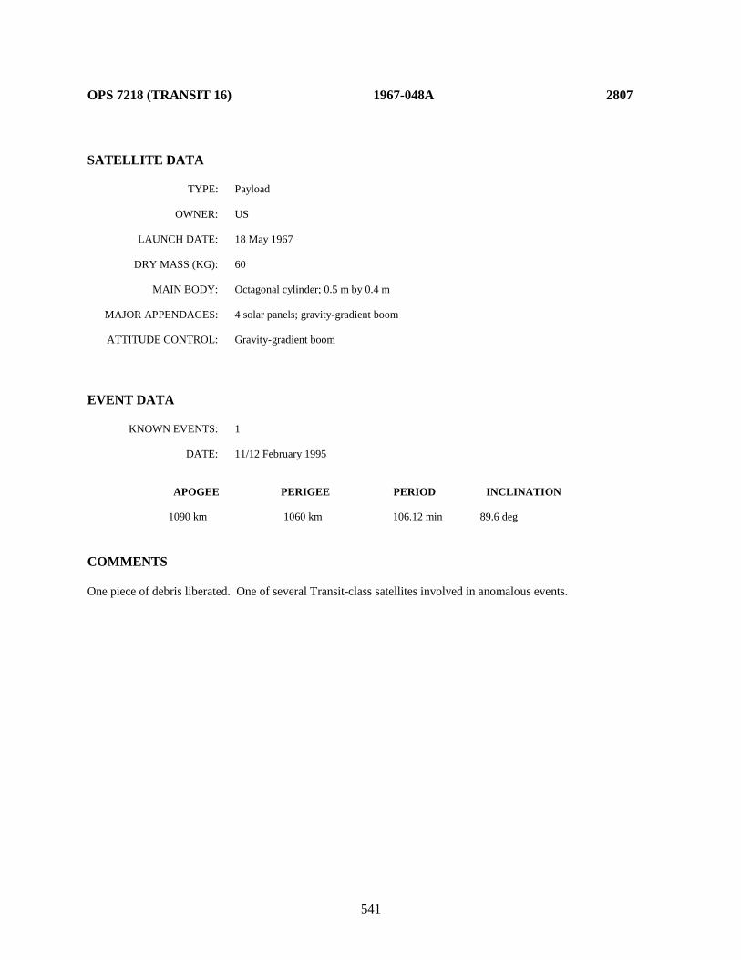
541
OPS 7218 (TRANSIT 16) 1967-048A 2807 SATELLITE DATA TYPE: Payload OWNER: US LAUNCH DATE: 18 May 1967 DRY MASS (KG): 60 MAIN BODY: Octagonal cylinder; 0.5 m by 0.4 m MAJOR APPENDAGES: 4 solar panels; gravity-gradient boom ATTITUDE CONTROL: Gravity-gradient boom EVENT DATA KNOWN EVENTS: 1 DATE: 11/12 February 1995 APOGEE PERIGEE PERIOD INCLINATION 1090 km 1060 km 106.12 min 89.6 deg COMMENTS One piece of debris liberated. One of several Transit-class satellites involved in anomalous events.

542
OPS 4947 (TRANSIT 17) 1967-092A 2965
SATELLITE DATA TYPE: Payload OWNER: US LAUNCH DATE: 25 September 1967 DRY MASS (KG): 60 MAIN BODY: Octagonal cylinder; 0.5 m by 0.4 m MAJOR APPENDAGES: 4 solar panels; gravity-gradient boom ATTITUDE CONTROL: Gravity-gradient EVENT DATA KNOWN EVENTS: 4 FIRST DATE: April 1981 APOGEE PERIGEE PERIOD INCLINATION 1110 km 1035 km 106.7 min 89.3 deg COMMENTS Second event observed in August 1986. One of several known Transits involved in anomalous events.
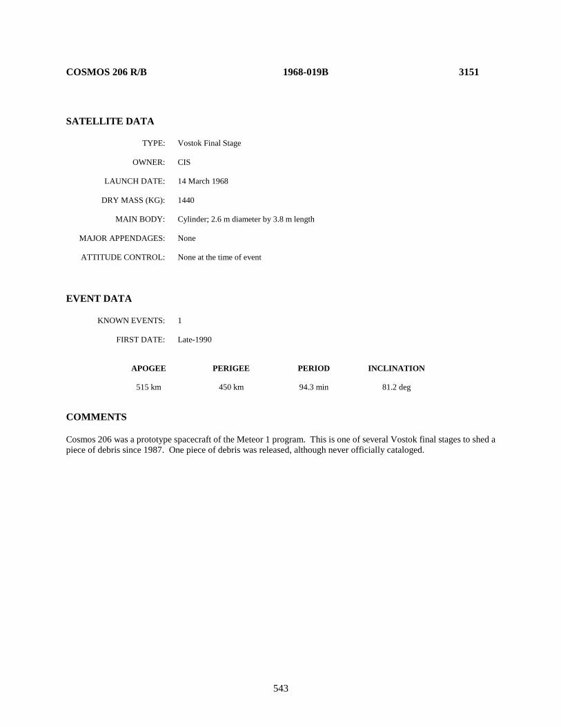
543
COSMOS 206 R/B 1968-019B 3151 SATELLITE DATA TYPE: Vostok Final Stage OWNER: CIS LAUNCH DATE: 14 March 1968 DRY MASS (KG): 1440 MAIN BODY: Cylinder; 2.6 m diameter by 3.8 m length MAJOR APPENDAGES: None ATTITUDE CONTROL: None at the time of event EVENT DATA KNOWN EVENTS: 1 FIRST DATE: Late-1990 APOGEE PERIGEE PERIOD INCLINATION 515 km 450 km 94.3 min 81.2 deg COMMENTS Cosmos 206 was a prototype spacecraft of the Meteor 1 program. This is one of several Vostok final stages to shed a piece of debris since 1987. One piece of debris was released, although never officially cataloged.
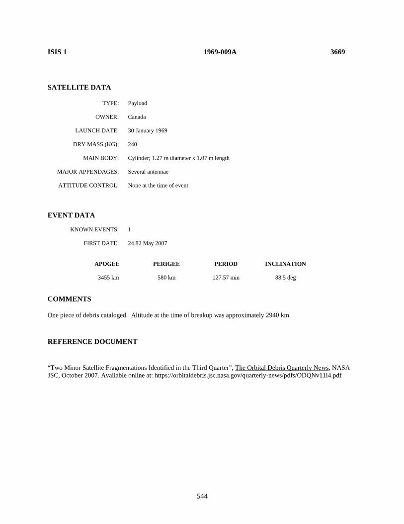
544
ISIS 1 1969-009A 3669 SATELLITE DATA TYPE: Payload OWNER: Canada LAUNCH DATE: 30 January 1969 DRY MASS (KG): 240 MAIN BODY: Cylinder; 1.27 m diameter x 1.07 m length MAJOR APPENDAGES: Several antennae ATTITUDE CONTROL: None at the time of event EVENT DATA KNOWN EVENTS: 1 FIRST DATE: 24.82 May 2007 APOGEE PERIGEE PERIOD INCLINATION 3455 km 580 km 127.57 min 88.5 deg COMMENTS One piece of debris cataloged. Altitude at the time of breakup was approximately 2940 km.
REFERENCE DOCUMENT
“Two Minor Satellite Fragmentations Identified in the Third Quarter”, The Orbital Debris Quarterly News, NASA JSC, October 2007. Available online at: https://orbitaldebris.jsc.nasa.gov/quarterly-news/pdfs/ODQNv11i4.pdf
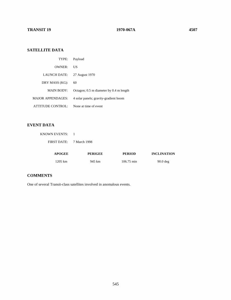
545
TRANSIT 19 1970-067A 4507 SATELLITE DATA TYPE: Payload OWNER: US LAUNCH DATE: 27 August 1970 DRY MASS (KG): 60 MAIN BODY: Octagon; 0.5 m diameter by 0.4 m length MAJOR APPENDAGES: 4 solar panels; gravity-gradient boom ATTITUDE CONTROL: None at time of event EVENT DATA KNOWN EVENTS: 1 FIRST DATE: 7 March 1998 APOGEE PERIGEE PERIOD INCLINATION 1205 km 945 km 106.75 min 90.0 deg COMMENTS One of several Transit-class satellites involved in anomalous events.

546
METEOR 1-7 R/B 1971-003B 4850 SATELLITE DATA TYPE: Vostok Final Stage OWNER: CIS LAUNCH DATE: 20 January 1971 DRY MASS (KG): 1440 MAIN BODY: Cylinder; 2.6 m diameter by 3.8 m length MAJOR APPENDAGES: None ATTITUDE CONTROL: None at time of the event. EVENT DATA KNOWN EVENTS: 1 FIRST DATE: June 1987 APOGEE PERIGEE PERIOD INCLINATION 665 km 535 km 96.7 min 81.2 deg COMMENTS No other events observed. One of several Vostok final stages to be involved in anomalous events.
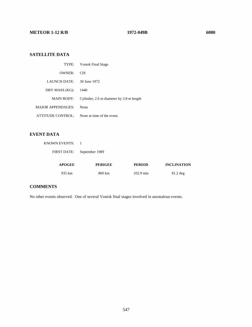
547
METEOR 1-12 R/B 1972-049B 6080 SATELLITE DATA TYPE: Vostok Final Stage OWNER: CIS LAUNCH DATE: 30 June 1972 DRY MASS (KG): 1440 MAIN BODY: Cylinder; 2.6 m diameter by 3.8 m length MAJOR APPENDAGES: None ATTITUDE CONTROL: None at time of the event. EVENT DATA KNOWN EVENTS: 1 FIRST DATE: September 1989 APOGEE PERIGEE PERIOD INCLINATION 935 km 860 km 102.9 min 81.2 deg COMMENTS No other events observed. One of several Vostok final stages involved in anomalous events.
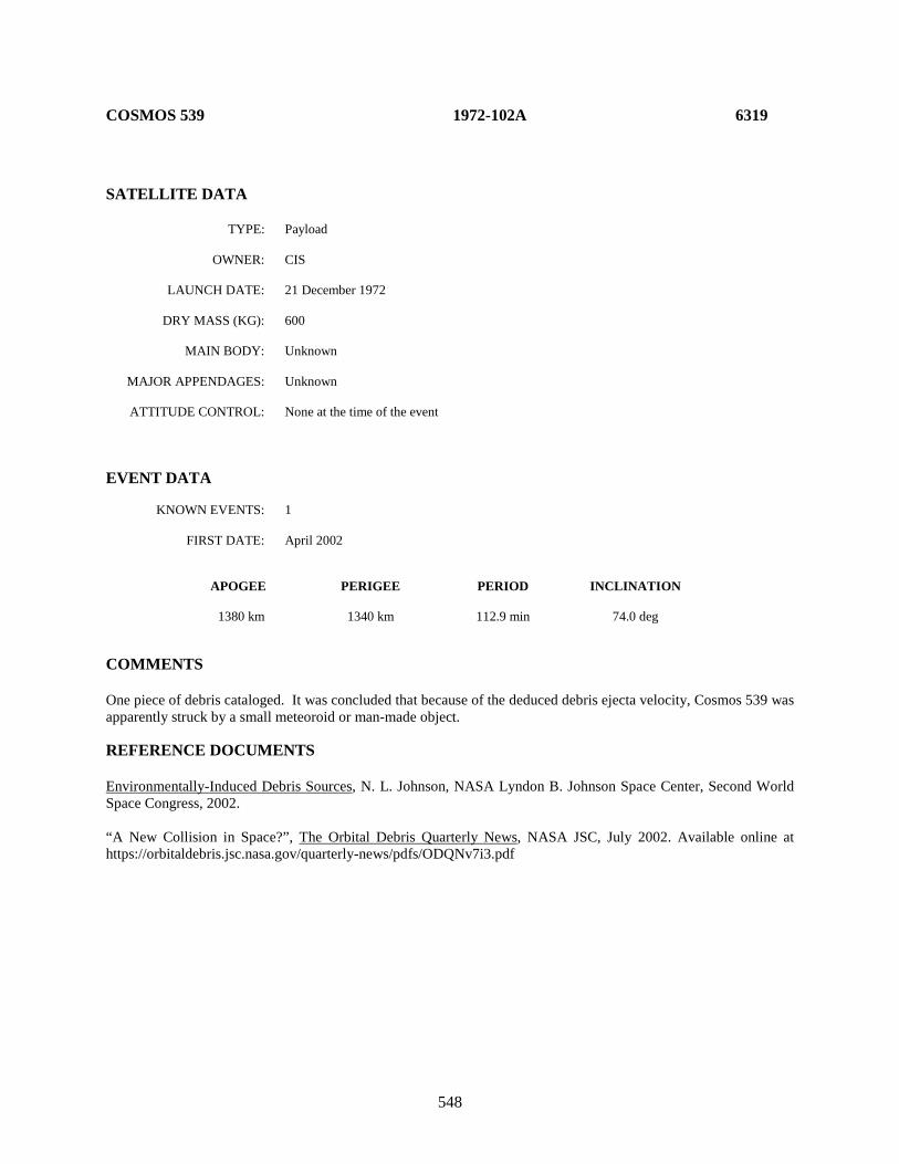
548
COSMOS 539 1972-102A 6319 SATELLITE DATA TYPE: Payload OWNER: CIS LAUNCH DATE: 21 December 1972 DRY MASS (KG): 600 MAIN BODY: Unknown MAJOR APPENDAGES: Unknown ATTITUDE CONTROL: None at the time of the event EVENT DATA KNOWN EVENTS: 1 FIRST DATE: April 2002 APOGEE PERIGEE PERIOD INCLINATION 1380 km 1340 km 112.9 min 74.0 deg COMMENTS One piece of debris cataloged. It was concluded that because of the deduced debris ejecta velocity, Cosmos 539 was apparently struck by a small meteoroid or man-made object. REFERENCE DOCUMENTS Environmentally-Induced Debris Sources, N. L. Johnson, NASA Lyndon B. Johnson Space Center, Second World Space Congress, 2002. “A New Collision in Space?”, The Orbital Debris Quarterly News, NASA JSC, July 2002. Available online at https://orbitaldebris.jsc.nasa.gov/quarterly-news/pdfs/ODQNv7i3.pdf
549
GEOS 3 R/B 1975-027B 7735 SATELLITE DATA TYPE: Delta Second Stage (2410) OWNER: US LAUNCH DATE: 9 April 1975 DRY MASS (KG): 900 MAIN BODY: Cylinder-nozzle; 2.4 m diameter by 8 m length MAJOR APPENDAGES: None ATTITUDE CONTROL: None at time of the event. EVENT DATA KNOWN EVENTS: 1 FIRST DATE: March 1978 APOGEE PERIGEE PERIOD INCLINATION 845 km 835 km 101.7 min 115.0 deg COMMENTS Only one event noted with three fragments cataloged 12 March 1978. There was repeated mis-tagging of objects during 1978 among rocket body and debris. One fragment lost in 1978 and administratively decayed in 1983. This event may be related to series of major Delta second stage breakups.

550
KYOKKOH 1 (EXOS-A) 1978-014A 10664 SATELLITE DATA TYPE: Payload OWNER: Japan LAUNCH DATE: 4 February 1978 DRY MASS (KG): 103 MAIN BODY: Octagonal cylinder; 0.95 m by 0.8 m MAJOR APPENDAGES: 3 small booms ATTITUDE CONTROL: Unknown EVENT DATA KNOWN EVENTS: 2 FIRST DATE: January 1988 APOGEE PERIGEE PERIOD INCLINATION 4219 km 760 km 134.0 min 65.0 deg COMMENTS First event (object 18816) may have occurred much earlier than the January 1988 date. Catalog actions taken at the end of 1988. The second event occurred in June 1992. Object 22008 led a short life, decaying on 2 August 1992.
551
SEASAT 1978-064A 10967 SATELLITE DATA TYPE: Payload (attached to Agena R/B) OWNER: US LAUNCH DATE: 27 June 1978 DRY MASS (KG): 2300 MAIN BODY: Cylinder; 1.5 m diameter by 21 m length MAJOR APPENDAGES: 2 solar panels; 1 antenna panel; miscellaneous booms ATTITUDE CONTROL: None at time of event EVENT DATA KNOWN EVENTS: Multiple FIRST DATE: July 1983 APOGEE PERIGEE PERIOD INCLINATION 780 km 780 km 100.5 min 108.0 deg COMMENTS On average, one piece of debris is released per year, but sometimes in groups. Most debris experience very rapid decay for this altitude. Last known release was in 2007.
REFERENCE DOCUMENTS
“Environmentally-Induced Debris Sources,” N.L. Johnson. Journal of Advances in Space Research, Vol. 34, Issue 5, 2004, pp. 993-999. “Detection of Debris from Chinese ASAT Test Increases; One Minor Fragmentation Event in Second Quarter of 2007”, The Orbital Debris Quarterly News, NASA JSC, July 2007. Available online at https://orbitaldebris.jsc.nasa.gov/quarterly-news/pdfs/ODQNv11i3.pdf.

552
COSMOS 1043 1978-094A 11055 SATELLITE DATA TYPE: Payload OWNER: CIS LAUNCH DATE: 10 October 1978 DRY MASS (KG): 2200 (est.) MAIN BODY: Cylinder; dimensions ∼1.5 m diameter by 5 m length MAJOR APPENDAGES: Solar panels; payload panels; gravity-gradient boom ATTITUDE CONTROL: None at time of the event. EVENT DATA KNOWN EVENTS: 1 FIRST DATE: February 1993 APOGEE PERIGEE PERIOD INCLINATION 437 km 435 km 94.9 min 81.2 deg COMMENTS No other satellite of this type has experienced an anomalous event. The piece was cataloged on 28 Feb 93 and decayed on 11 Mar 93. Given prior cataloging practices, other spacecraft could have experienced similar events that went unrecorded.

553
TIROS N 1978-096A 11060 SATELLITE DATA TYPE: Payload OWNER: US LAUNCH DATE: 13 October 1978 DRY MASS (KG): 725 MAIN BODY: Cylinder; 1.9 m diameter by 3.7 m length MAJOR APPENDAGES: 1 solar panel ATTITUDE CONTROL: None at time of the event EVENT DATA KNOWN EVENTS: 2 FIRST DATE: September 1987 APOGEE PERIGEE PERIOD INCLINATION 855 km 835 km 101.9 min 99.0 deg COMMENTS Both fragments from the first event decayed rapidly during winter of 1988-89. A second event associated with 1978-096A occurred on 23 Feb 96 liberating 1 piece.
554
NIMBUS 7 R/B 1978-098B 11081 SATELLITE DATA TYPE: Delta Second Stage (2910) OWNER: US LAUNCH DATE: 24 October 1978 DRY MASS (KG): 900 MAIN BODY: Cylinder-nozzle; 2.4 m diameter by 8 m length MAJOR APPENDAGES: None ATTITUDE CONTROL: None at time of the event. EVENT DATA KNOWN EVENTS: 2 FIRST DATE: May 1981 APOGEE PERIGEE PERIOD INCLINATION 955 km 935 km 104.0 min 99.3 deg COMMENTS Second anomalous event apparently occurred about January 1987. A more prolific event in December 1981 is tentatively categorized as a satellite breakup (see Section 2). The cataloged debris section above refers only to the new fragment observed after the second anomalous event and does not include the Delta second stage that is accounted for in the tables of Section 2. These events may be related to the series of major Delta second stage breakups.

555
NOAA 6 1979-057A 11416 SATELLITE DATA TYPE: Payload OWNER: US LAUNCH DATE: 27 June 1979 DRY MASS (KG): 723 MAIN BODY: Rectangular; 3.71 m by 1.88 m MAJOR APPENDAGES: Solar panels ATTITUDE CONTROL: 3-axis reaction control EVENT DATA KNOWN EVENTS: 2 FIRST DATE: September 1992 APOGEE PERIGEE PERIOD INCLINATION 810 km 795 km 100.8 min 98.68 deg COMMENTS One piece of debris cataloged from the first event. A second event took place in June 1995 with one piece of debris liberated, but none cataloged. REFERENCE DOCUMENT Environmentally-Induced Debris Sources, N. L. Johnson, NASA Lyndon B. Johnson Space Center, Second World Space Congress, 2002.
556
METEOR 2-5 1979-095A 11605 SATELLITE DATA TYPE: Payload OWNER: CIS LAUNCH DATE: 31 Oct 1979 DRY MASS (KG): 2750 MAIN BODY: Cylinder MAJOR APPENDAGES: Large Solar Arrays ATTITUDE CONTROL: None at the time of event EVENT DATA KNOWN EVENTS: Multiple FIRST DATE: prior to 1 Jan. 2005; orbital data for 1 Jan. 2014. APOGEE PERIGEE PERIOD INCLINATION 880.7 km 862 km 102.35 min 81.2 deg COMMENTS Multiple anomalous debris from multiple individual events; the origination date of the pieces is not conclusive. The last event occurred as recently as late 2013 to early 2014.
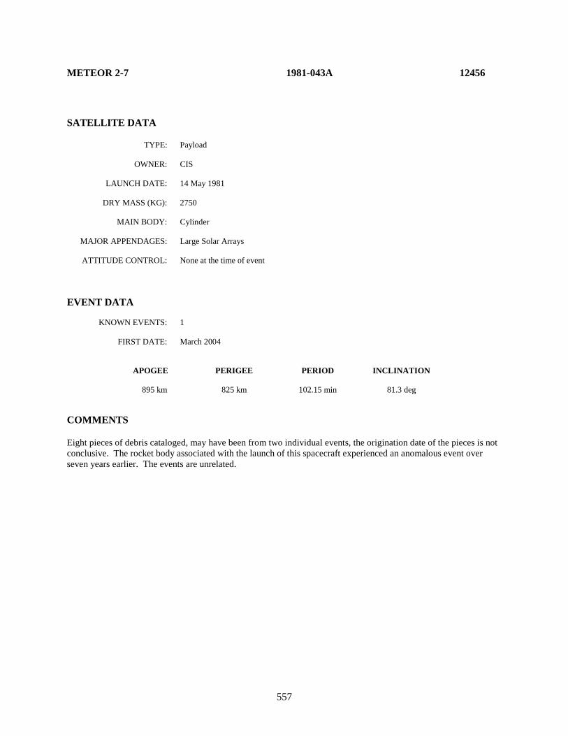
557
METEOR 2-7 1981-043A 12456 SATELLITE DATA TYPE: Payload OWNER: CIS LAUNCH DATE: 14 May 1981 DRY MASS (KG): 2750 MAIN BODY: Cylinder MAJOR APPENDAGES: Large Solar Arrays ATTITUDE CONTROL: None at the time of event EVENT DATA KNOWN EVENTS: 1 FIRST DATE: March 2004 APOGEE PERIGEE PERIOD INCLINATION 895 km 825 km 102.15 min 81.3 deg COMMENTS Eight pieces of debris cataloged, may have been from two individual events, the origination date of the pieces is not conclusive. The rocket body associated with the launch of this spacecraft experienced an anomalous event over seven years earlier. The events are unrelated.
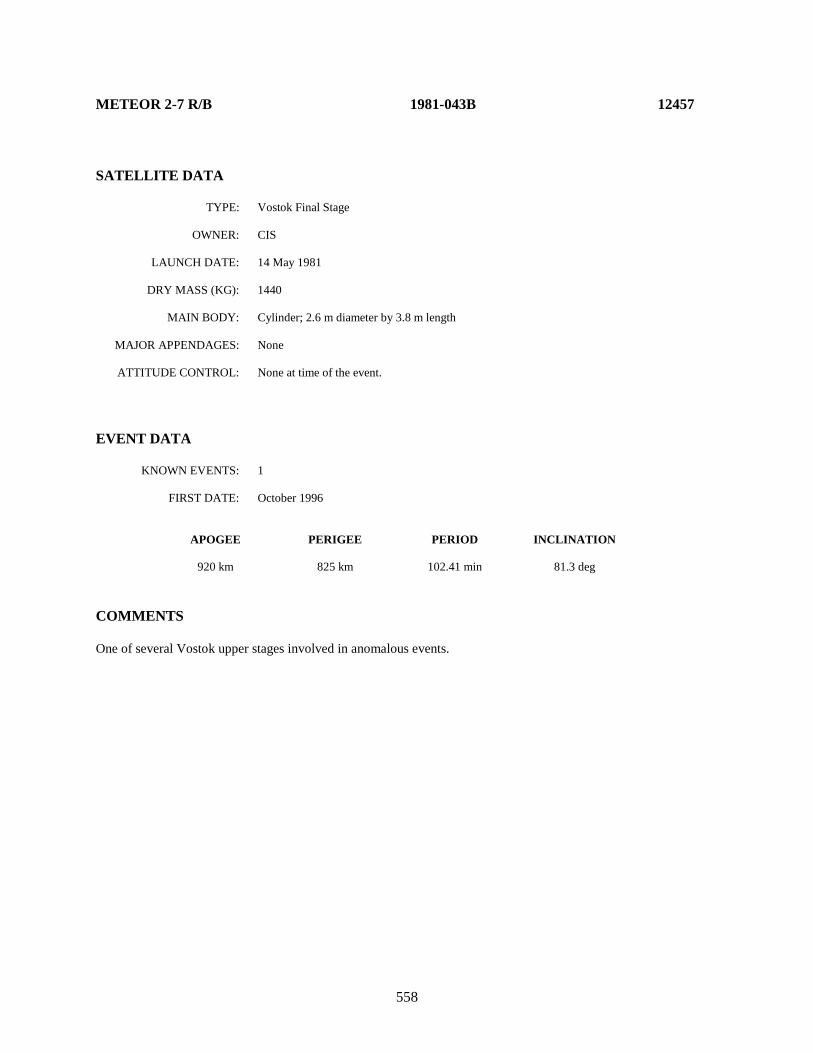
558
METEOR 2-7 R/B 1981-043B 12457 SATELLITE DATA TYPE: Vostok Final Stage OWNER: CIS LAUNCH DATE: 14 May 1981 DRY MASS (KG): 1440 MAIN BODY: Cylinder; 2.6 m diameter by 3.8 m length MAJOR APPENDAGES: None ATTITUDE CONTROL: None at time of the event. EVENT DATA KNOWN EVENTS: 1 FIRST DATE: October 1996 APOGEE PERIGEE PERIOD INCLINATION 920 km 825 km 102.41 min 81.3 deg COMMENTS One of several Vostok upper stages involved in anomalous events.

559
MOLNIYA 3-16 R/B 1981-054E 12519 SATELLITE DATA TYPE: Molniya Final Stage OWNER: CIS LAUNCH DATE: 9 Jun 1981 DRY MASS (KG): 1100 MAIN BODY: Cylinder; 2.7 m diameter by 3 m length MAJOR APPENDAGES: None ATTITUDE CONTROL: None EVENT DATA KNOWN EVENTS: 1 FIRST DATE: July 1998 APOGEE PERIGEE PERIOD INCLINATION 33415 km 85 km 583.42 min 62.0 deg COMMENTS No debris was cataloged from this event.

560
NOAA 7 1981-059A 12553 SATELLITE DATA TYPE: Payload OWNER: US LAUNCH DATE: 23 June 1981 DRY MASS (KG): 723 MAIN BODY: Rectangular; 3.71 m by 1.88 m MAJOR APPENDAGES: Solar panels ATTITUDE CONTROL: None at the time of event EVENT DATA KNOWN EVENTS: 2 FIRST DATE: 26.5 July 1993 APOGEE PERIGEE PERIOD INCLINATION 835 km 830 km 101.6 min 98.9 deg COMMENTS Two objects were detected by the NAVSPOC and subsequently entered in the US SSN catalog. A piece separation analysis by the NAVSPOC identified the precise time these objects separated from the parent. It is unclear whether this event is a small breakup or whether other explanations such as spacecraft degradation could explain this separation. Unless other evidence is uncovered, this event will be classified as an anomalous event. The NOAA 7 payload was inactive for 3 years prior to this event. In 1997 a second, more curious event occurred. Three new debris appeared simultaneously with a discrete decrease in the orbital period of NOAA 7 of approximately 1 second. REFERENCE DOCUMENT Environmentally-Induced Debris Sources, N. L. Johnson, NASA Lyndon B. Johnson Space Center, Second World Space Congress, 2002.
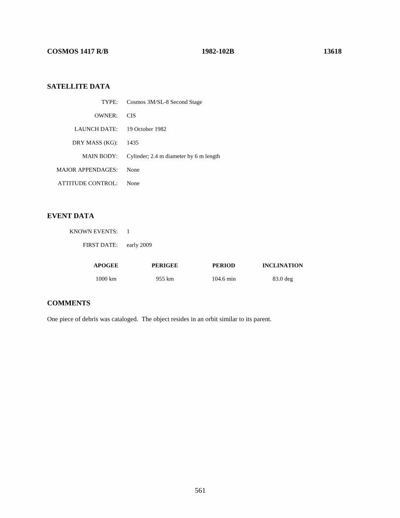
561
COSMOS 1417 R/B 1982-102B 13618 SATELLITE DATA TYPE: Cosmos 3M/SL-8 Second Stage OWNER: CIS LAUNCH DATE: 19 October 1982 DRY MASS (KG): 1435 MAIN BODY: Cylinder; 2.4 m diameter by 6 m length MAJOR APPENDAGES: None ATTITUDE CONTROL: None EVENT DATA KNOWN EVENTS: 1 FIRST DATE: early 2009 APOGEE PERIGEE PERIOD INCLINATION 1000 km 955 km 104.6 min 83.0 deg COMMENTS One piece of debris was cataloged. The object resides in an orbit similar to its parent.
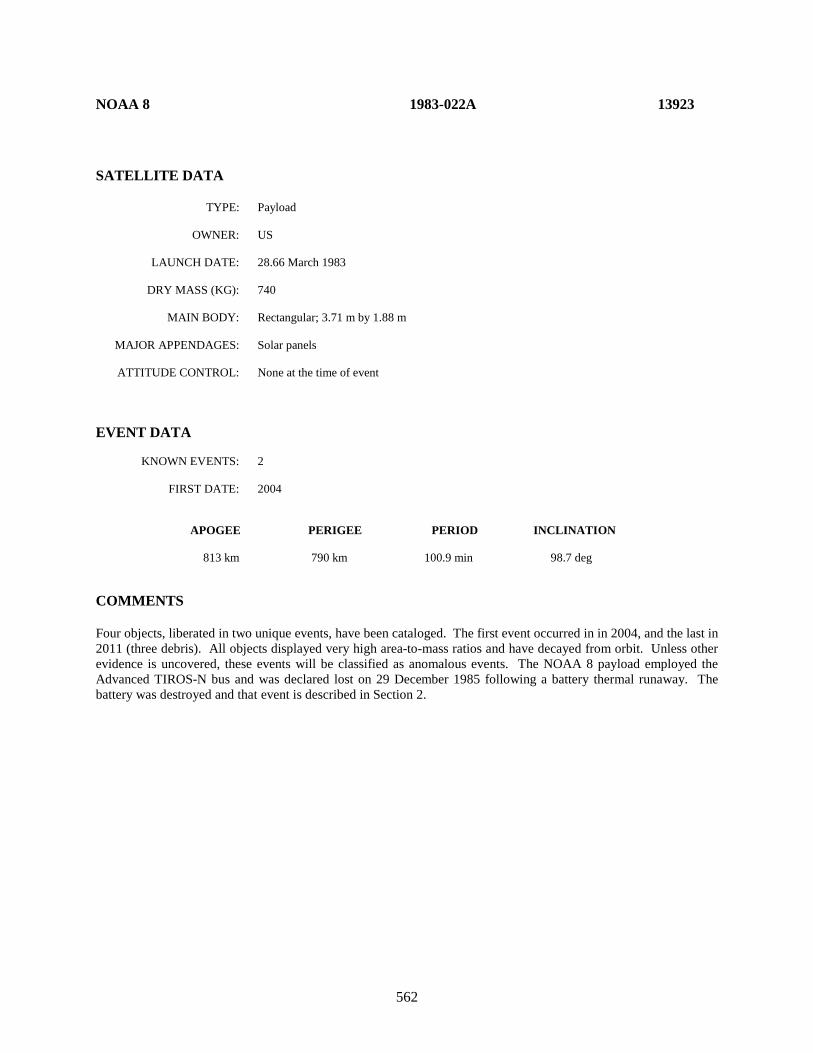
562
NOAA 8 1983-022A 13923 SATELLITE DATA TYPE: Payload OWNER: US LAUNCH DATE: 28.66 March 1983 DRY MASS (KG): 740 MAIN BODY: Rectangular; 3.71 m by 1.88 m MAJOR APPENDAGES: Solar panels ATTITUDE CONTROL: None at the time of event EVENT DATA KNOWN EVENTS: 2 FIRST DATE: 2004 APOGEE PERIGEE PERIOD INCLINATION 813 km 790 km 100.9 min 98.7 deg COMMENTS Four objects, liberated in two unique events, have been cataloged. The first event occurred in in 2004, and the last in 2011 (three debris). All objects displayed very high area-to-mass ratios and have decayed from orbit. Unless other evidence is uncovered, these events will be classified as anomalous events. The NOAA 8 payload employed the Advanced TIROS-N bus and was declared lost on 29 December 1985 following a battery thermal runaway. The battery was destroyed and that event is described in Section 2.

563
OSCAR 30 1985-066A 15935
SATELLITE DATA TYPE: Payload OWNER: US LAUNCH DATE: 3 August 1985 DRY MASS (KG): 60 MAIN BODY: Octagonal cylinder; 0.5 m by 0.4 m MAJOR APPENDAGES: 4 solar panels; gravity-gradient boom ATTITUDE CONTROL: Gravity-gradient boom EVENT DATA KNOWN EVENTS: 1 FIRST DATE: 27 December 1991 APOGEE PERIGEE PERIOD INCLINATION 1255 km 1000 km 107.8 min 89.9 deg COMMENTS Other debris pieces are associated with this dual payload launch. The most recent event identified (SCC 21878) apparently originated from Oscar 30 on 27 December 1991, when a portion of the gravity-gradient boom broke off. One of several Transit-class satellites involved in anomalous events. REFERENCE DOCUMENT “The Transit System,” L. Lee Pryor, AIAA Paper 92-1708, Applied Physics Laboratory, 1992.

564
COSMOS 1689 R/B 1985-090B 16111 SATELLITE DATA TYPE: Vostok Final Stage OWNER: CIS LAUNCH DATE: 3 October 1985 DRY MASS (KG): 1440 MAIN BODY: Cylinder; 2.6 m diameter by 3.8 m length MAJOR APPENDAGES: None ATTITUDE CONTROL: None at the time of the event. EVENT DATA KNOWN EVENTS: 1 FIRST DATE: May 2002 APOGEE PERIGEE PERIOD INCLINATION 565 km 510 km 95.4 min 97.7 deg COMMENTS One of several Vostok stages involved in anomalous events.
565
NOAA 10 1986-073A 16969 SATELLITE DATA TYPE: Payload OWNER: US LAUNCH DATE: 17.66 September 1986 DRY MASS (KG): 740 MAIN BODY: Rectangular; 3.71 m by 1.88 m MAJOR APPENDAGES: Solar panels ATTITUDE CONTROL: None at the time of event EVENT DATA KNOWN EVENTS: 3 FIRST DATE: April 2000 APOGEE PERIGEE PERIOD INCLINATION 816 km 799 km 101.0 min 98.6 deg COMMENTS Four objects, liberated in three unique events, have been cataloged. The first event occurred in April 2000, the second in 2007, and the last in 2010. All objects displayed very high area-to-mass ratios and have decayed from orbit. Unless other evidence is uncovered, this event will be classified as an anomalous event. The NOAA 10 payload employed the Advanced TIROS-N bus, was placed into a standby status on 17 September 1991 and had been decommissioned on 30 August 2001.

566
COSMOS 1818 1987-011A 17369 SATELLITE DATA TYPE: Payload OWNER: CIS LAUNCH DATE: 23.86 April 1987 DRY MASS (KG): 2500 MAIN BODY: cylinder-cone 1.4 m diameter x 9.3 m long MAJOR APPENDAGES: ~ 3 m beam extending from base of cylindrical section ATTITUDE CONTROL: inactive at time of event ENERGY SOURCES: inactive nuclear power source; other sources speculative EVENT DATA KNOWN EVENTS: 1 FIRST DATE: 04 Jul 2008 APOGEE PERIGEE PERIOD INCLINATION 803 774 100.62 min 65.0 deg COMMENTS Cosmos 1818 was the first of two Plazma-A spacecraft, the second being Cosmos 1867. These spacecraft used a thermionic nuclear power reactor in lieu of the thermoelectric reactors aboard the predecessor Radar Ocean Reconnaissance (RORSAT) spacecraft series. However, like RORSATs, the Plazma-A spacecraft used sodium-potassium (NaK) as a coolant. Cosmos 1818’s operational lifetime is estimated to be approximately five months. The event occurred after approximately 21.4 years on orbit. Radar observations indicate signatures consistent with small, metallic spheres, most likely NaK coolant droplets. REFERENCE DOCUMENT “New Debris Seen from Decommissioned Satellite with Nuclear Power Source”, The Orbital Debris Quarterly News, NASA JSC, January 2009. Available online at https://orbitaldebris.jsc.nasa.gov/quarterly-news/pdfs/ODQNv13i1.pdf.
567
COSMOS 1823 1987-020A 17535 SATELLITE DATA TYPE: Payload OWNER: CIS LAUNCH DATE: 20.20 Feb 1987 DRY MASS (KG): 1500 MAIN BODY: Cylinder; 2.4 m diameter by 4 m length MAJOR APPENDAGES: Gravity-gradient boom; 10 small solar panels ATTITUDE CONTROL: Gravity gradient EVENT DATA KNOWN EVENTS: 3 FIRST DATE: Apr-May 1997 APOGEE PERIGEE PERIOD INCLINATION 1525 km 1480 km 116.0 min 73.6 deg COMMENTS Cosmos 1823 appears to have experienced three separate anomalous events, two in 1997 and one in 1999. Because Cosmos 1823 suffered a serious fragmentation in December 1987, the anomalous debris pieces may have been loosely attached to the spacecraft, then separated after continued exposure to the space environment or change in attitude of the spacecraft remnant. REFERENCE DOCUMENTS History of Soviet/Russian Satellite Fragmentations-A Joint U.S.-Russian Investigation, N. L. Johnson et al, Kaman Sciences Corporation, October 1995. Environmentally-Induced Debris Sources, N. L. Johnson, NASA Lyndon B. Johnson Space Center, Second World Space Congress, 2002.
568
METEOR 2-17 1988-005A 18820 SATELLITE DATA TYPE: Payload OWNER: CIS LAUNCH DATE: 30 January 1988 DRY MASS (KG): 2750 MAIN BODY: Cylinder MAJOR APPENDAGES: Large Solar Arrays ATTITUDE CONTROL: None at the time of event EVENT DATA KNOWN EVENTS: 2 FIRST DATE: 2000-2001 APOGEE PERIGEE PERIOD INCLINATION 960 936 104 min 82.5 deg COMMENTS One debris object separated from the parent spacecraft in ’00-’01 time frame, the second in the ’02-’03 time frame. The debris were tracked under various analyst satellite numbers until being cataloged in 2012 as SSN 38540 and 38543.
569
COSMOS 1867 1987-060A 18187 SATELLITE DATA TYPE: Payload OWNER: CIS LAUNCH DATE: 10.65 July 1987 DRY MASS (KG): 2500 MAIN BODY: cylinder-cone 1.4 m diameter x 9.3 m long MAJOR APPENDAGES: ~ 3 m beam extending from base of cylindrical section ATTITUDE CONTROL: inactive at time of event ENERGY SOURCES: inactive nuclear power source; other sources speculative EVENT DATA KNOWN EVENTS: 1 FIRST DATE: 21 March to 4 April 2014 APOGEE PERIGEE PERIOD INCLINATION 802 776 100.63 min 65.0 deg COMMENTS Cosmos 1867 was the second of two Plazma-A spacecraft, the first being Cosmos 1818. These spacecraft used a thermionic nuclear power reactor in lieu of the thermoelectric reactors aboard the predecessor Radar Ocean Reconnaissance (RORSAT) spacecraft series. However, like RORSATs, the Plazma-A spacecraft used sodium-potassium (NaK) as a coolant. Cosmos 1867’s operational lifetime is estimated to be approximately five months. The event occurred after approximately 26.9 years on orbit and was an extended event. Radar observations indicate signatures consistent with small, metallic spheres, most likely NaK coolant droplets.
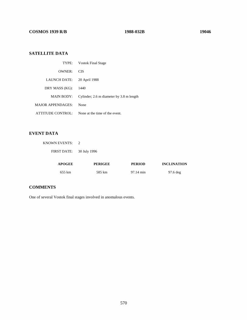
570
COSMOS 1939 R/B 1988-032B 19046 SATELLITE DATA TYPE: Vostok Final Stage OWNER: CIS LAUNCH DATE: 20 April 1988 DRY MASS (KG): 1440 MAIN BODY: Cylinder; 2.6 m diameter by 3.8 m length MAJOR APPENDAGES: None ATTITUDE CONTROL: None at the time of the event. EVENT DATA KNOWN EVENTS: 2 FIRST DATE: 30 July 1996 APOGEE PERIGEE PERIOD INCLINATION 655 km 585 km 97.14 min 97.6 deg COMMENTS One of several Vostok final stages involved in anomalous events.

571
NOAA 11 1988-089A 19531 SATELLITE DATA TYPE: Payload OWNER: US LAUNCH DATE: 24.42 September 1988 DRY MASS (KG): 740 MAIN BODY: Rectangular; 3.71 m by 1.88 m MAJOR APPENDAGES: Solar panels ATTITUDE CONTROL: None at the time of event EVENT DATA KNOWN EVENTS: 1 FIRST DATE: 24 November 2010 APOGEE PERIGEE PERIOD INCLINATION 816 km 799 km 101.0 min 98.6 deg COMMENTS Two low area-to-mass ratio objects have been cataloged. Unless other evidence is uncovered, this event will be classified as an anomalous event. The NOAA 11 payload employed the Advanced TIROS-N bus and was decommissioned on 16 June 2004. This event occurred approximately 6.4 years after decommissioning.

572
COBE 1989-089A 20322 SATELLITE DATA TYPE: Payload OWNER: US LAUNCH DATE: 18.61 November 1989 DRY MASS (KG): 2265 MAIN BODY: Cylinder; with protective shield, 4.0 m diameter by 5.8 m length MAJOR APPENDAGES: 3 - 8.6 m solar arrays ATTITUDE CONTROL: Spin stabilized; gyroscopes EVENT DATA KNOWN EVENTS: Multiple FIRST DATE: January 1993 APOGEE PERIGEE PERIOD INCLINATION 885 km 870 km 102.5 min 99.0 deg COMMENTS At least 12 separate event dates have been calculated by the NAVSPOC, and other events are certain to have occurred. Through December 1993 the satellite remained active, and the cause of the separations could be determined. No degradation of satellite performance was reported by the satellite operators. REFERENCE DOCUMENT Environmentally-Induced Debris Sources, N. L. Johnson, NASA Lyndon B. Johnson Space Center, Second World Space Congress, 2002.

573
NADEZHDA 2 R/B 1990-017B 20509 SATELLITE DATA TYPE: Rocket Body OWNER: CIS LAUNCH DATE: 27 February 1990 DRY MASS (KG): 1434 MAIN BODY: Cylinder; 2.4 m diameter x 6.0 m length MAJOR APPENDAGES: None ATTITUDE CONTROL: None at the time of the event EVENT DATA KNOWN EVENTS: 1 FIRST DATE: 22 June 2005 APOGEE PERIGEE PERIOD INCLINATION 1015 950 104.65 min 83.0 deg COMMENTS A piece was detected in a more eccentric and higher inclination orbit, indicating that this event may have been a collision with a small, uncataloged object or meteoroid. REFERENCE DOCUMENT “Recent Satellite Breakups”, The Orbital Debris Quarterly News, NASA JSC, July 2005. Available online at https://orbitaldebris.jsc.nasa.gov/quarterly-news/pdfs/ODQNv9i3.pdf.
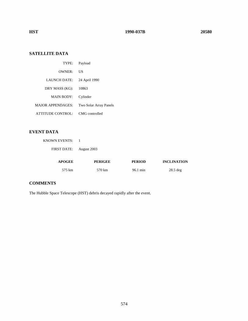
574
HST 1990-037B 20580 SATELLITE DATA TYPE: Payload OWNER: US LAUNCH DATE: 24 April 1990 DRY MASS (KG): 10863 MAIN BODY: Cylinder MAJOR APPENDAGES: Two Solar Array Panels ATTITUDE CONTROL: CMG controlled EVENT DATA KNOWN EVENTS: 1 FIRST DATE: August 2003 APOGEE PERIGEE PERIOD INCLINATION 575 km 570 km 96.1 min 28.5 deg COMMENTS The Hubble Space Telescope (HST) debris decayed rapidly after the event.

575
NOAA 12 1991-032A 21263 SATELLITE DATA TYPE: Payload OWNER: US LAUNCH DATE: 14.66 May 1991 DRY MASS (KG): 740 MAIN BODY: Rectangular; 3.71 m by 1.88 m MAJOR APPENDAGES: Solar panels ATTITUDE CONTROL: None at the time of event EVENT DATA KNOWN EVENTS: 1 FIRST DATE: 2 October 2011 APOGEE PERIGEE PERIOD INCLINATION 815 km 800 km 100 min 98.7 deg COMMENTS Four low area-to-mass ratio objects have been cataloged. Unless other evidence is uncovered, this event will be classified as an anomalous event. The NOAA 12 (NOAA D pre-launch) payload employed the last TIROS-N bus, No. 5, and was decommissioned on 10 August 2007. This event occurred approximately 4.1 years after decommissioning.
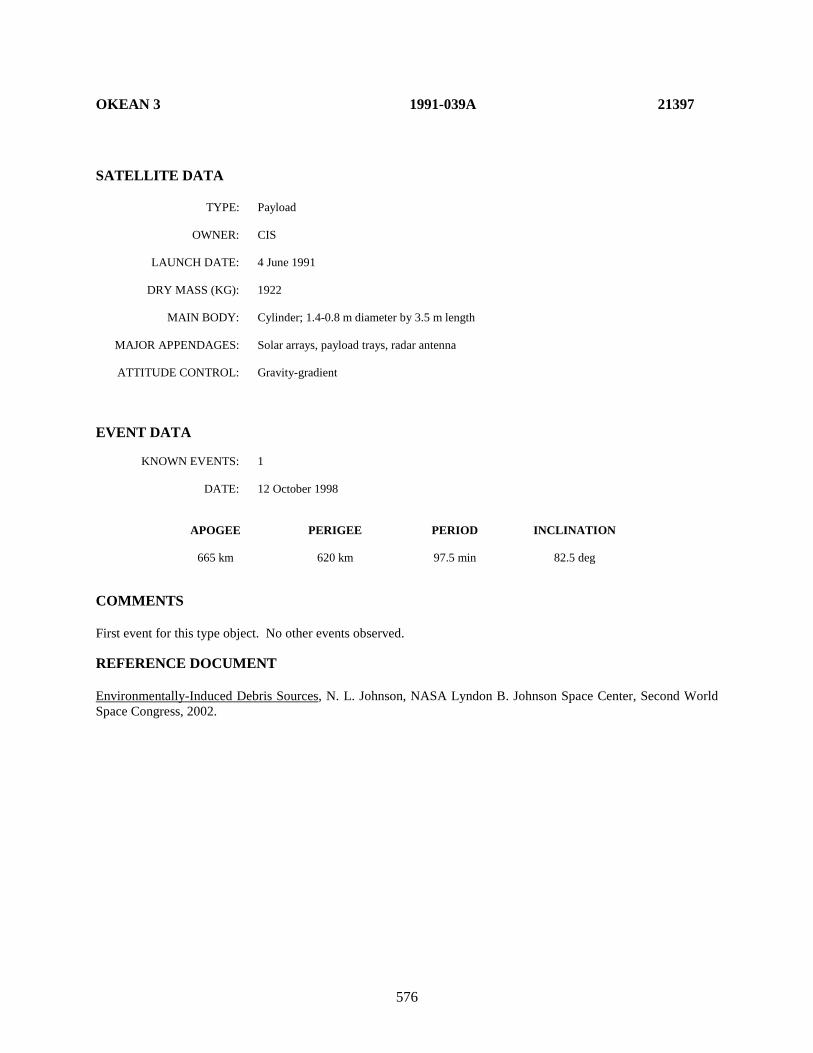
576
OKEAN 3 1991-039A 21397 SATELLITE DATA TYPE: Payload OWNER: CIS LAUNCH DATE: 4 June 1991 DRY MASS (KG): 1922 MAIN BODY: Cylinder; 1.4-0.8 m diameter by 3.5 m length MAJOR APPENDAGES: Solar arrays, payload trays, radar antenna ATTITUDE CONTROL: Gravity-gradient EVENT DATA KNOWN EVENTS: 1 DATE: 12 October 1998 APOGEE PERIGEE PERIOD INCLINATION 665 km 620 km 97.5 min 82.5 deg COMMENTS First event for this type object. No other events observed. REFERENCE DOCUMENT Environmentally-Induced Debris Sources, N. L. Johnson, NASA Lyndon B. Johnson Space Center, Second World Space Congress, 2002.

577
ERS-1 1991-050A 21574 SATELLITE DATA TYPE: Payload OWNER: ESA LAUNCH DATE: 17 July 1991 DRY MASS (KG): 2084 MAIN BODY: SPOT Mk. 1 bus. Cubical box. Approximately 2 m x 2 m x 3 m long payload support module;
11.8 m length overall when antennas and solar panel deployed. MAJOR APPENDAGES: Solar Array Panel, multiple instruments and antennas ATTITUDE CONTROL: CMG/monopropellant thrusters; inactive at time of event EVENT DATA KNOWN EVENTS: 7 FIRST DATE: 7 July 2002 APOGEE PERIGEE PERIOD INCLINATION 801.6 km 750.8 km 100.3 min 98.5 deg COMMENTS Seven debris objects were cataloged from seven unique production events, the most recent being in 2017. The ERS-1 mission ended on 10 March 2000 due to the failure of the attitude control system, approximately 2.3 years before the initial release event.
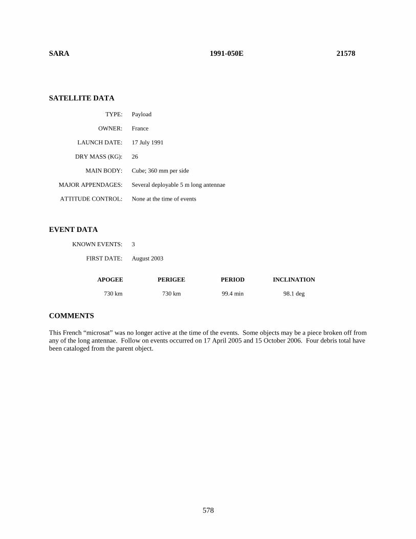
578
SARA 1991-050E 21578
SATELLITE DATA TYPE: Payload OWNER: France LAUNCH DATE: 17 July 1991 DRY MASS (KG): 26 MAIN BODY: Cube; 360 mm per side MAJOR APPENDAGES: Several deployable 5 m long antennae ATTITUDE CONTROL: None at the time of events EVENT DATA KNOWN EVENTS: 3 FIRST DATE: August 2003 APOGEE PERIGEE PERIOD INCLINATION 730 km 730 km 99.4 min 98.1 deg COMMENTS This French “microsat” was no longer active at the time of the events. Some objects may be a piece broken off from any of the long antennae. Follow on events occurred on 17 April 2005 and 15 October 2006. Four debris total have been cataloged from the parent object.

579
ERS-1 R/B 1991-050F 21610 SATELLITE DATA TYPE: Ariane 40 Rocket Body OWNER: France LAUNCH DATE: 17 July 1991 DRY MASS (KG): 1720 MAIN BODY: Cylinder; 2.6 m diameter by 10 m length MAJOR APPENDAGES: None ATTITUDE CONTROL: None EVENT DATA KNOWN EVENTS: 1 FIRST DATE: April 2001 APOGEE PERIGEE PERIOD INCLINATION 770 km 770 km 100.2 min 98.2 deg COMMENTS One piece of debris cataloged. Parent object was in a sun-synchronous orbit at the time of the event. First occurrence of an anomalous event with an Ariane R/B. REFERENCE DOCUMENT Environmentally-Induced Debris Sources, N. L. Johnson, NASA Lyndon B. Johnson Space Center, Second World Space Congress, 2002.
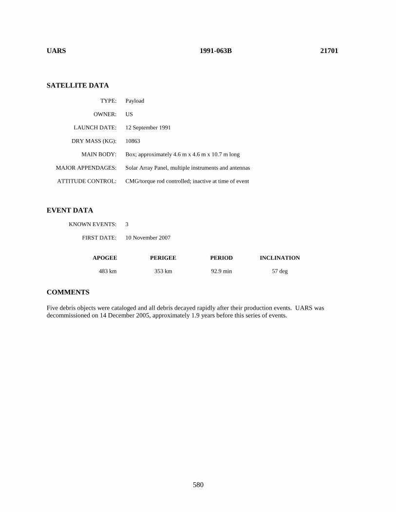
580
UARS 1991-063B 21701 SATELLITE DATA TYPE: Payload OWNER: US LAUNCH DATE: 12 September 1991 DRY MASS (KG): 10863 MAIN BODY: Box; approximately 4.6 m x 4.6 m x 10.7 m long MAJOR APPENDAGES: Solar Array Panel, multiple instruments and antennas ATTITUDE CONTROL: CMG/torque rod controlled; inactive at time of event EVENT DATA KNOWN EVENTS: 3 FIRST DATE: 10 November 2007 APOGEE PERIGEE PERIOD INCLINATION 483 km 353 km 92.9 min 57 deg COMMENTS Five debris objects were cataloged and all debris decayed rapidly after their production events. UARS was decommissioned on 14 December 2005, approximately 1.9 years before this series of events.
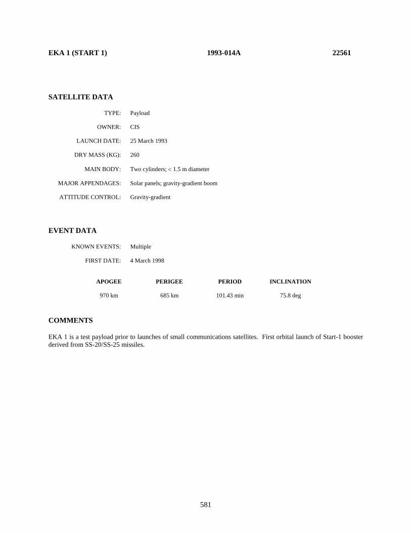
581
EKA 1 (START 1) 1993-014A 22561
SATELLITE DATA TYPE: Payload OWNER: CIS LAUNCH DATE: 25 March 1993 DRY MASS (KG): 260 MAIN BODY: Two cylinders; < 1.5 m diameter MAJOR APPENDAGES: Solar panels; gravity-gradient boom ATTITUDE CONTROL: Gravity-gradient EVENT DATA KNOWN EVENTS: Multiple FIRST DATE: 4 March 1998 APOGEE PERIGEE PERIOD INCLINATION 970 km 685 km 101.43 min 75.8 deg COMMENTS EKA 1 is a test payload prior to launches of small communications satellites. First orbital launch of Start-1 booster derived from SS-20/SS-25 missiles.
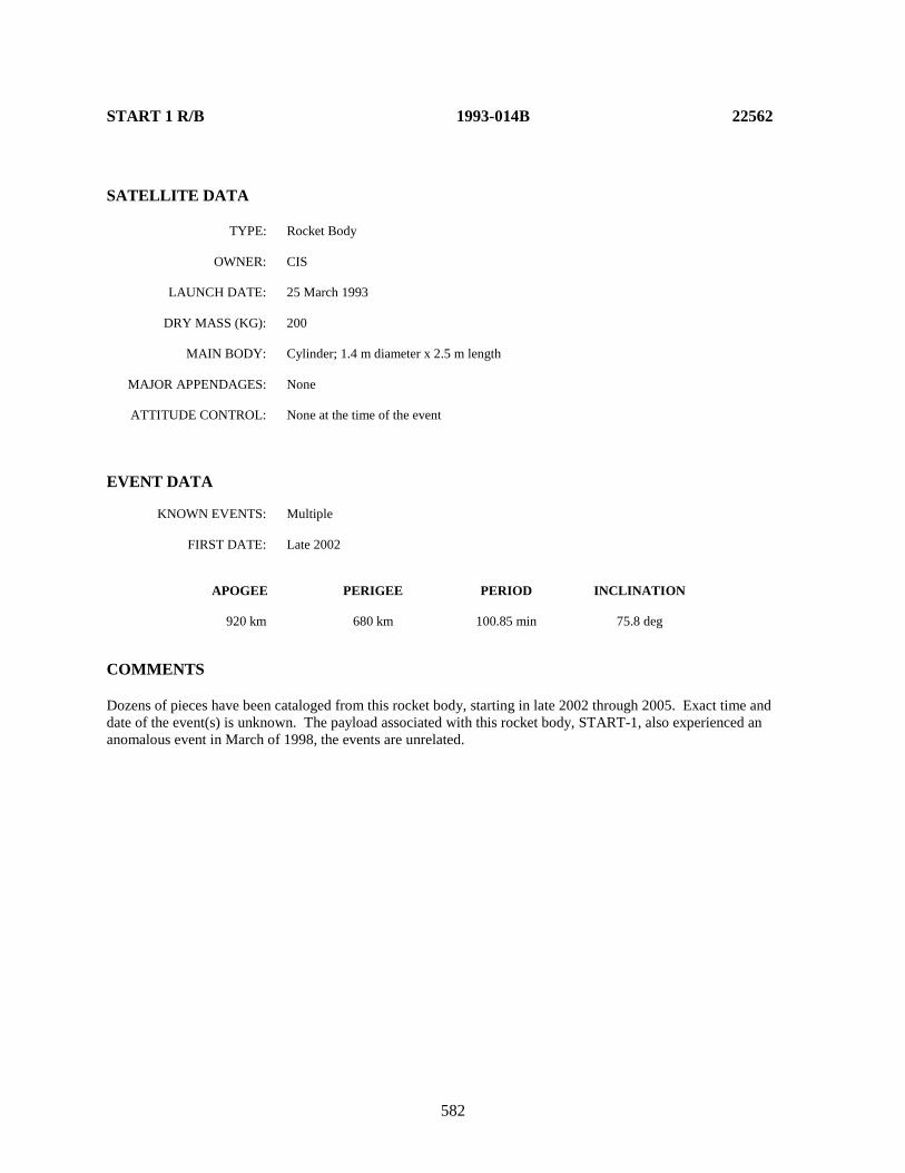
582
START 1 R/B 1993-014B 22562 SATELLITE DATA TYPE: Rocket Body OWNER: CIS LAUNCH DATE: 25 March 1993 DRY MASS (KG): 200 MAIN BODY: Cylinder; 1.4 m diameter x 2.5 m length MAJOR APPENDAGES: None ATTITUDE CONTROL: None at the time of the event EVENT DATA KNOWN EVENTS: Multiple FIRST DATE: Late 2002 APOGEE PERIGEE PERIOD INCLINATION 920 km 680 km 100.85 min 75.8 deg COMMENTS Dozens of pieces have been cataloged from this rocket body, starting in late 2002 through 2005. Exact time and date of the event(s) is unknown. The payload associated with this rocket body, START-1, also experienced an anomalous event in March of 1998, the events are unrelated.
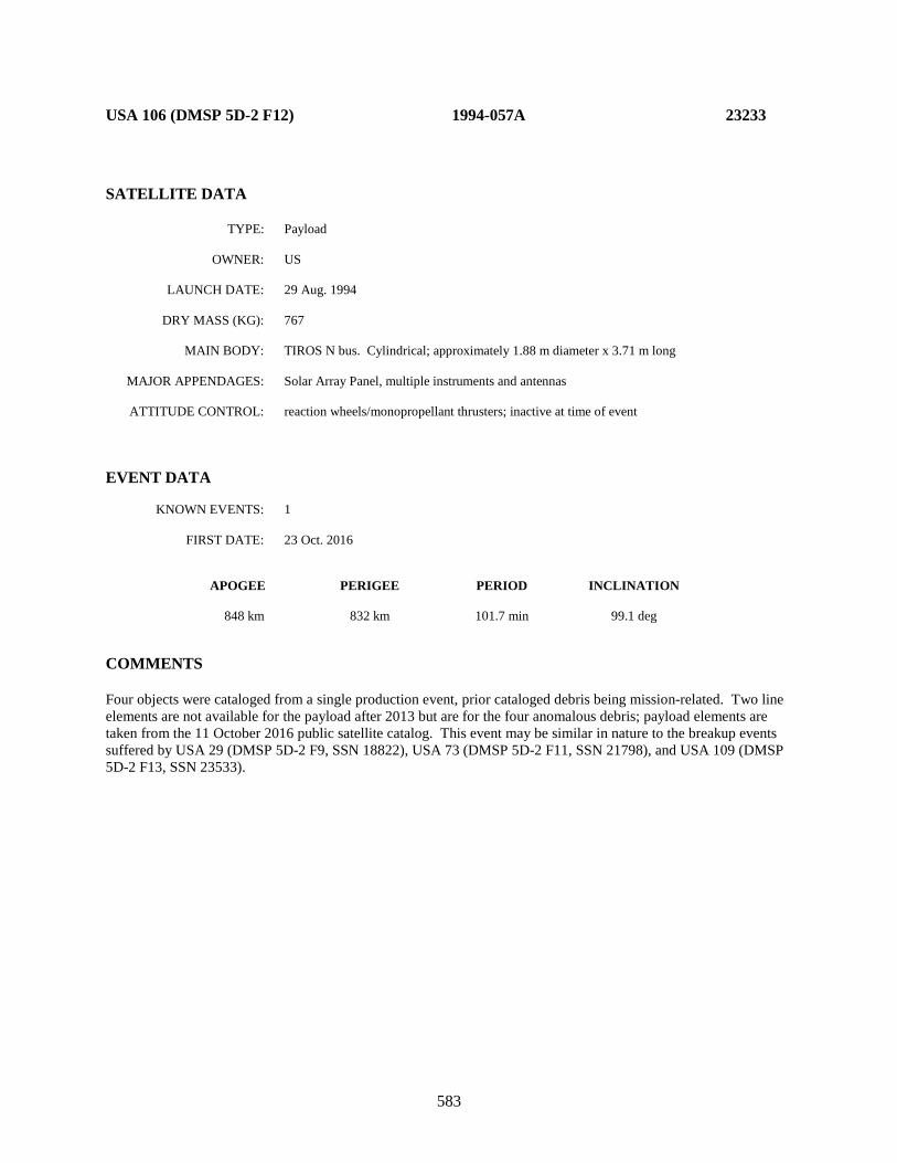
583
USA 106 (DMSP 5D-2 F12) 1994-057A 23233 SATELLITE DATA TYPE: Payload OWNER: US LAUNCH DATE: 29 Aug. 1994 DRY MASS (KG): 767 MAIN BODY: TIROS N bus. Cylindrical; approximately 1.88 m diameter x 3.71 m long MAJOR APPENDAGES: Solar Array Panel, multiple instruments and antennas ATTITUDE CONTROL: reaction wheels/monopropellant thrusters; inactive at time of event EVENT DATA KNOWN EVENTS: 1 FIRST DATE: 23 Oct. 2016 APOGEE PERIGEE PERIOD INCLINATION 848 km 832 km 101.7 min 99.1 deg COMMENTS Four objects were cataloged from a single production event, prior cataloged debris being mission-related. Two line elements are not available for the payload after 2013 but are for the four anomalous debris; payload elements are taken from the 11 October 2016 public satellite catalog. This event may be similar in nature to the breakup events suffered by USA 29 (DMSP 5D-2 F9, SSN 18822), USA 73 (DMSP 5D-2 F11, SSN 21798), and USA 109 (DMSP 5D-2 F13, SSN 23533).

584
COSMOS 2297 R/B 1994-077B 23405 SATELLITE DATA TYPE: Zenit Second Stage OWNER: CIS LAUNCH DATE: 24 November 1994 DRY MASS (KG): 8300 MAIN BODY: Cylinder; 3.9 m diameter by 12 m length MAJOR APPENDAGES: None ATTITUDE CONTROL: None EVENT DATA KNOWN EVENTS: 2? FIRST DATE: June 1998 APOGEE PERIGEE PERIOD INCLINATION 845 km 845 km 101.82 min 71.0 deg COMMENTS One piece of debris was cataloged. REFERENCE DOCUMENTS History of Soviet/Russian Satellite Fragmentations-A Joint U.S.-Russian Investigation, N. L. Johnson et al, Kaman Sciences Corporation, October 1995. Environmentally-Induced Debris Sources, N. L. Johnson, NASA Lyndon B. Johnson Space Center, Second World Space Congress, 2002.
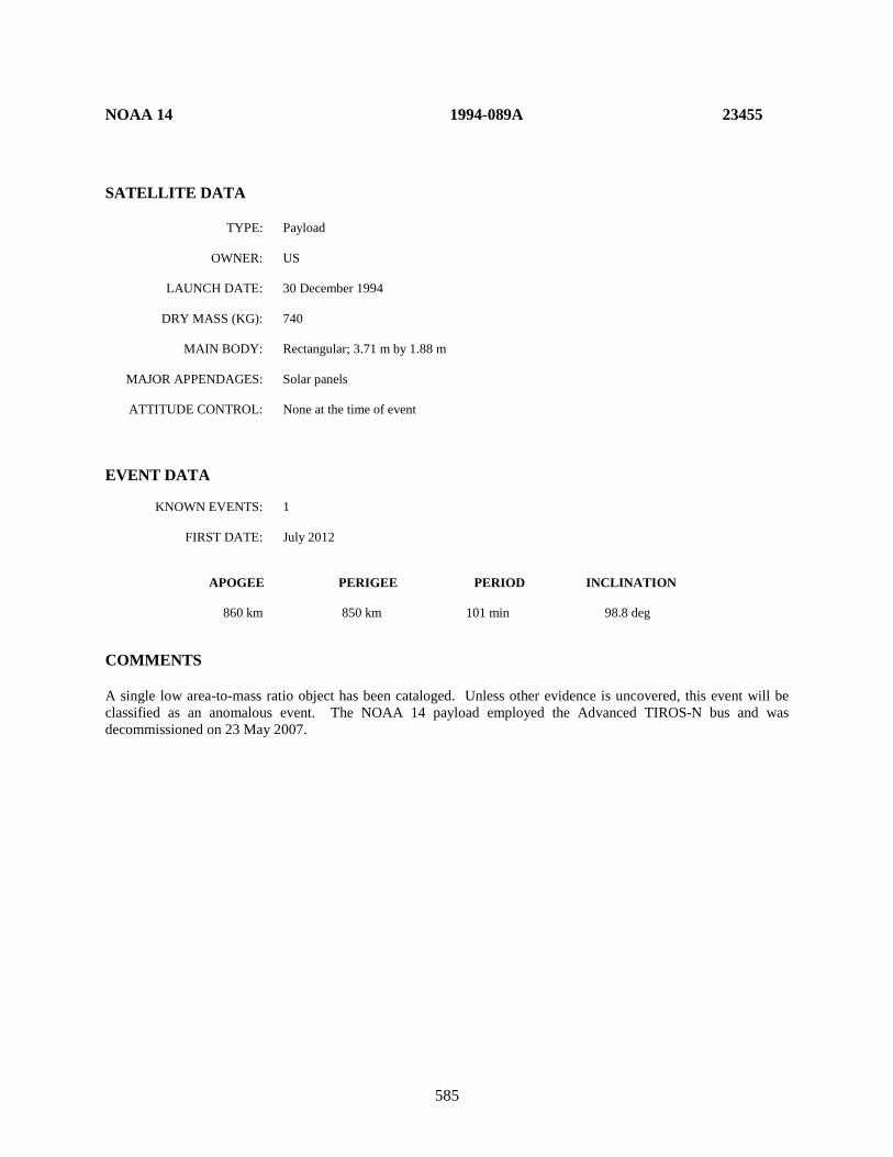
585
NOAA 14 1994-089A 23455 SATELLITE DATA TYPE: Payload OWNER: US LAUNCH DATE: 30 December 1994 DRY MASS (KG): 740 MAIN BODY: Rectangular; 3.71 m by 1.88 m MAJOR APPENDAGES: Solar panels ATTITUDE CONTROL: None at the time of event EVENT DATA KNOWN EVENTS: 1 FIRST DATE: July 2012 APOGEE PERIGEE PERIOD INCLINATION 860 km 850 km 101 min 98.8 deg COMMENTS A single low area-to-mass ratio object has been cataloged. Unless other evidence is uncovered, this event will be classified as an anomalous event. The NOAA 14 payload employed the Advanced TIROS-N bus and was decommissioned on 23 May 2007.
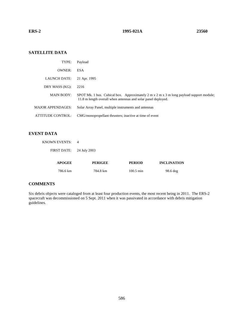
586
ERS-2 1995-021A 23560 SATELLITE DATA TYPE: Payload OWNER: ESA LAUNCH DATE: 21 Apr. 1995 DRY MASS (KG): 2216 MAIN BODY: SPOT Mk. 1 bus. Cubical box. Approximately 2 m x 2 m x 3 m long payload support module;
11.8 m length overall when antennas and solar panel deployed. MAJOR APPENDAGES: Solar Array Panel, multiple instruments and antennas ATTITUDE CONTROL: CMG/monopropellant thrusters; inactive at time of event EVENT DATA KNOWN EVENTS: 4 FIRST DATE: 24 July 2003 APOGEE PERIGEE PERIOD INCLINATION 786.6 km 784.8 km 100.5 min 98.6 deg COMMENTS Six debris objects were cataloged from at least four production events, the most recent being in 2011. The ERS-2 spacecraft was decommissioned on 5 Sept. 2011 when it was passivated in accordance with debris mitigation guidelines.

587
ERS-2 R/B 1995-021B 23561 SATELLITE DATA TYPE: Ariane 40+ Rocket Body OWNER: France LAUNCH DATE: 21 Apr. 1995 DRY MASS (KG): 1720 MAIN BODY: Cylinder; 2.6 m diameter by 10 m length MAJOR APPENDAGES: None ATTITUDE CONTROL: None EVENT DATA KNOWN EVENTS: 1 FIRST DATE: prior to 1 Jan. 2018 APOGEE PERIGEE PERIOD INCLINATION 772.4 km 761.6 km 100.1 min 98.8 deg COMMENTS One piece of debris (SSN 43351) cataloged. Parent object was in a sun-synchronous orbit at the time of the event. “Event data” epoch is 1 Jan. 2018 but actual separation time was earlier.
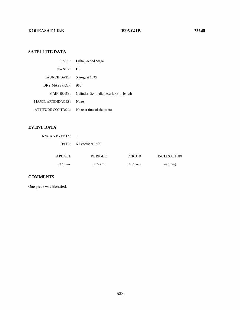
588
KOREASAT 1 R/B 1995-041B 23640 SATELLITE DATA TYPE: Delta Second Stage OWNER: US LAUNCH DATE: 5 August 1995 DRY MASS (KG): 900 MAIN BODY: Cylinder; 2.4 m diameter by 8 m length MAJOR APPENDAGES: None ATTITUDE CONTROL: None at time of the event. EVENT DATA KNOWN EVENTS: 1 DATE: 6 December 1995 APOGEE PERIGEE PERIOD INCLINATION 1375 km 935 km 108.5 min 26.7 deg COMMENTS One piece was liberated.

589
RADARSAT R/B 1995-059B 23711 SATELLITE DATA TYPE: Delta Second Stage OWNER: US LAUNCH DATE: 5 November 1995 DRY MASS (KG): 900 MAIN BODY: Cylinder; 2.4 m diameter by 8 m length MAJOR APPENDAGES: None ATTITUDE CONTROL: None EVENT DATA KNOWN EVENTS: 1 DATE: 30 January 1996 APOGEE PERIGEE PERIOD INCLINATION 1495 km 935 km 109.7 min 100.6 deg COMMENTS One piece was liberated.

590
IRS B3 1996-017A 23827 SATELLITE DATA TYPE: Payload OWNER: India LAUNCH DATE: 21 March 1996 DRY MASS (KG): 838 MAIN BODY: Cubical box; 1.6 m x 1.6 m by 1.2 m high MAJOR APPENDAGES: Solar panels ATTITUDE CONTROL: three-axis stabilized; reaction wheels, torque rods, and monopropellant reaction control system EVENT DATA KNOWN EVENTS: 1 FIRST DATE: October 2000 APOGEE PERIGEE PERIOD INCLINATION 821.9 km 820.3 km 101.3 min 98.6 deg COMMENTS A single relatively high area-to-mass ratio object has been cataloged. “Event Data” epoch is 30 October 2000. Unless other evidence is uncovered, this event will be classified as an anomalous event. The payload was operational at the time of separation and was decommissioned in January 2006.

591
IRIDIUM 47 1997-082C 25106 SATELLITE DATA TYPE: Payload OWNER: US LAUNCH DATE: 20 December 1997 DRY MASS (KG): 556 MAIN BODY: Triangular prism, 3.6 m long MAJOR APPENDAGES: Two solar arrays, three antennas ATTITUDE CONTROL: Three-axis stabilized EVENT DATA KNOWN EVENTS: 1 FIRST DATE: 7 June 2014 APOGEE PERIGEE PERIOD INCLINATION 781 km 778 km 100.4 min 86.4 deg COMMENTS Ten pieces of debris were cataloged from this event. Three of the cataloged debris had reentered within 10 months indicating relatively large area-to-mass ratios. The event did not affect vehicle operations or performance. REFERENCE DOCUMENT “Iridium Anomalous Debris Events”, The Orbital Debris Quarterly News, NASA JSC, January 2015. Available online at https://orbitaldebris.jsc.nasa.gov/quarterly-news/pdfs/odqnv19i1.pdf.
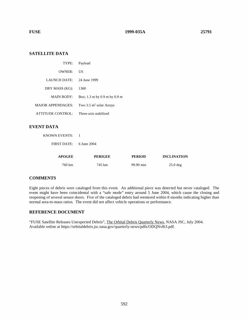
592
FUSE 1999-035A 25791 SATELLITE DATA TYPE: Payload OWNER: US LAUNCH DATE: 24 June 1999 DRY MASS (KG): 1360 MAIN BODY: Box; 1.3 m by 0.9 m by 0.9 m MAJOR APPENDAGES: Two 3.5 m2 solar Arrays ATTITUDE CONTROL: Three-axis stabilized EVENT DATA KNOWN EVENTS: 1 FIRST DATE: 6 June 2004 APOGEE PERIGEE PERIOD INCLINATION 760 km 745 km 99.90 min 25.0 deg COMMENTS Eight pieces of debris were cataloged from this event. An additional piece was detected but never cataloged. The event might have been coincidental with a “safe mode” entry around 5 June 2004, which cause the closing and reopening of several sensor doors. Five of the cataloged debris had reentered within 8 months indicating higher than normal area-to-mass ratios. The event did not affect vehicle operations or performance. REFERENCE DOCUMENT “FUSE Satellite Releases Unexpected Debris”, The Orbital Debris Quarterly News, NASA JSC, July 2004. Available online at https://orbitaldebris.jsc.nasa.gov/quarterly-news/pdfs/ODQNv8i3.pdf.

593
TELKOM 1 1999-042A 25880 SATELLITE DATA TYPE: Payload OWNER: Indonesia LAUNCH DATE: 12 Aug. 1999 DRY MASS (KG): 1640 MAIN BODY: Lockheed-Martin A2100A bus. Cubical box; 1.8 m x 1.8 m by 3.7 m high MAJOR APPENDAGES: Solar panels ATTITUDE CONTROL: three-axis stabilized; reaction wheels and monopropellant reaction control system EVENT DATA KNOWN EVENTS: 1 FIRST DATE: 25 Aug. 2017 APOGEE PERIGEE PERIOD INCLINATION 35793 km 35781 km 1436.1 min 0.01 deg COMMENTS This event occurred after approximately 18.1 years on-orbit, three years past the nominal operational lifetime. The payload was operational at the time of the event. No debris have been cataloged as of this edition. REFERENCE DOCUMENT “Two Anomalous Events in GEO”, The Orbital Debris Quarterly News, NASA JSC, February 2018. Available online at https://www.orbitaldebris.jsc.nasa.gov/quarterly-news/pdfs/odqnv22i1.pdf.
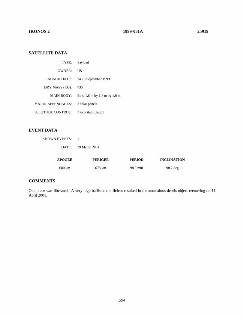
594
IKONOS 2 1999-051A 25919 SATELLITE DATA TYPE: Payload OWNER: US LAUNCH DATE: 24.76 September 1999 DRY MASS (KG): 735 MAIN BODY: Box; 1.8 m by 1.8 m by 1.6 m MAJOR APPENDAGES: 3 solar panels ATTITUDE CONTROL: 3 axis stabilization EVENT DATA KNOWN EVENTS: 1 DATE: 19 March 2001 APOGEE PERIGEE PERIOD INCLINATION 680 km 678 km 98.3 min 98.2 deg COMMENTS One piece was liberated. A very high ballistic coefficient resulted in the anomalous debris object reentering on 11 April 2001.
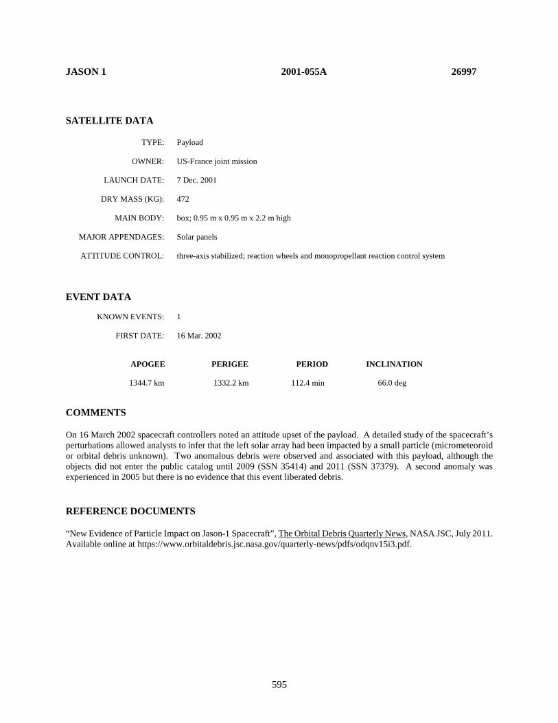
595
JASON 1 2001-055A 26997 SATELLITE DATA TYPE: Payload OWNER: US-France joint mission LAUNCH DATE: 7 Dec. 2001 DRY MASS (KG): 472 MAIN BODY: box; 0.95 m x 0.95 m x 2.2 m high MAJOR APPENDAGES: Solar panels ATTITUDE CONTROL: three-axis stabilized; reaction wheels and monopropellant reaction control system EVENT DATA KNOWN EVENTS: 1 FIRST DATE: 16 Mar. 2002 APOGEE PERIGEE PERIOD INCLINATION 1344.7 km 1332.2 km 112.4 min 66.0 deg COMMENTS On 16 March 2002 spacecraft controllers noted an attitude upset of the payload. A detailed study of the spacecraft’s perturbations allowed analysts to infer that the left solar array had been impacted by a small particle (micrometeoroid or orbital debris unknown). Two anomalous debris were observed and associated with this payload, although the objects did not enter the public catalog until 2009 (SSN 35414) and 2011 (SSN 37379). A second anomaly was experienced in 2005 but there is no evidence that this event liberated debris. REFERENCE DOCUMENTS “New Evidence of Particle Impact on Jason-1 Spacecraft”, The Orbital Debris Quarterly News, NASA JSC, July 2011. Available online at https://www.orbitaldebris.jsc.nasa.gov/quarterly-news/pdfs/odqnv15i3.pdf.
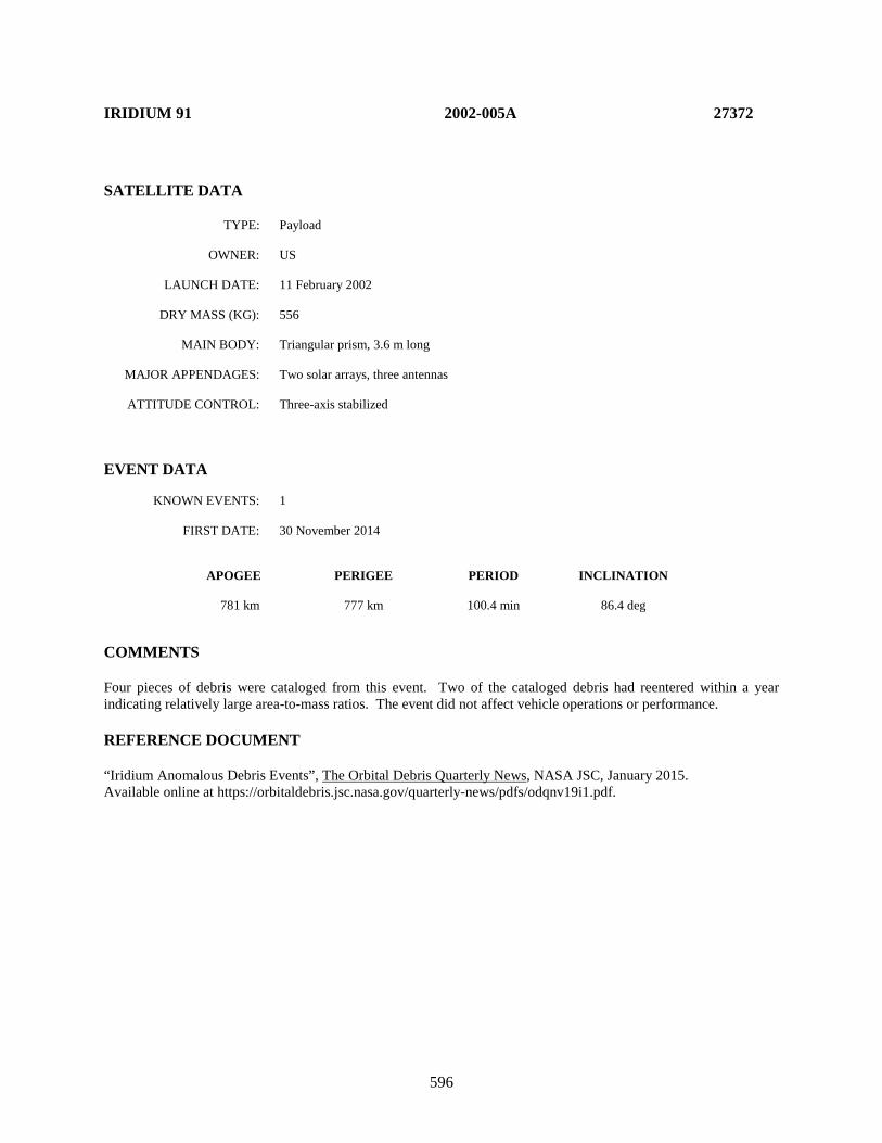
596
IRIDIUM 91 2002-005A 27372 SATELLITE DATA TYPE: Payload OWNER: US LAUNCH DATE: 11 February 2002 DRY MASS (KG): 556 MAIN BODY: Triangular prism, 3.6 m long MAJOR APPENDAGES: Two solar arrays, three antennas ATTITUDE CONTROL: Three-axis stabilized EVENT DATA KNOWN EVENTS: 1 FIRST DATE: 30 November 2014 APOGEE PERIGEE PERIOD INCLINATION 781 km 777 km 100.4 min 86.4 deg COMMENTS Four pieces of debris were cataloged from this event. Two of the cataloged debris had reentered within a year indicating relatively large area-to-mass ratios. The event did not affect vehicle operations or performance. REFERENCE DOCUMENT “Iridium Anomalous Debris Events”, The Orbital Debris Quarterly News, NASA JSC, January 2015. Available online at https://orbitaldebris.jsc.nasa.gov/quarterly-news/pdfs/odqnv19i1.pdf.

597
AMC-9 (GE-12) 2003-024A 27820 SATELLITE DATA TYPE: Payload OWNER: SES (formerly Société Européenne des Satellites; Luxembourg) LAUNCH DATE: 6 June 2003 DRY MASS (KG): 1663 MAIN BODY: Thales Alenia Space Spacebus-3000B3 bus. Cubical box; 3.2 m x 2.4 m by 4 m high MAJOR APPENDAGES: Solar panels ATTITUDE CONTROL: three-axis stabilized; reaction wheels and bipropellant reaction control system EVENT DATA KNOWN EVENTS: 1 FIRST DATE: 17 June 2017 APOGEE PERIGEE PERIOD INCLINATION 35798 km 35774 km 1436.1 min 0.02 deg COMMENTS This event occurred after approximately 14 years on-orbit. The payload was operational at the time of the event and was subsequently boosted to the so-called GEO “graveyard orbit.” No debris have been cataloged as of this edition. REFERENCE DOCUMENT “Two Anomalous Events in GEO”, The Orbital Debris Quarterly News, NASA JSC, February 2018. Available online at https://www.orbitaldebris.jsc.nasa.gov/quarterly-news/pdfs/odqnv22i1.pdf.
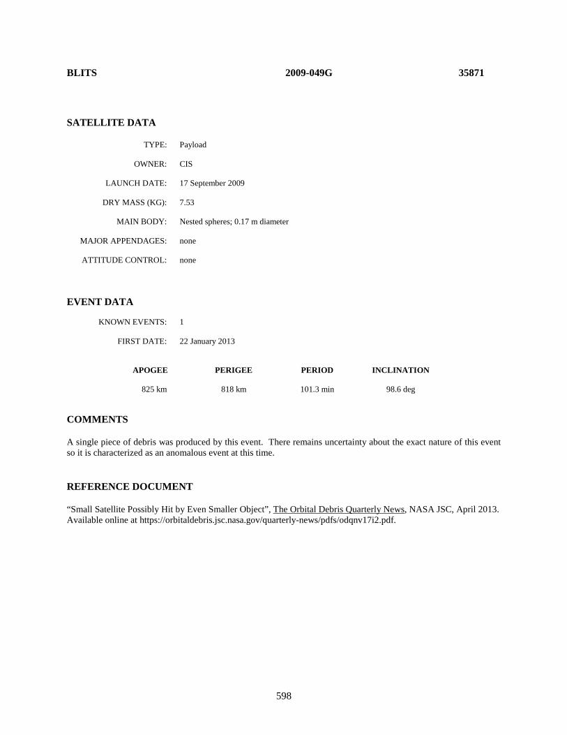
598
BLITS 2009-049G 35871 SATELLITE DATA TYPE: Payload OWNER: CIS LAUNCH DATE: 17 September 2009 DRY MASS (KG): 7.53 MAIN BODY: Nested spheres; 0.17 m diameter MAJOR APPENDAGES: none ATTITUDE CONTROL: none EVENT DATA KNOWN EVENTS: 1 FIRST DATE: 22 January 2013 APOGEE PERIGEE PERIOD INCLINATION 825 km 818 km 101.3 min 98.6 deg COMMENTS A single piece of debris was produced by this event. There remains uncertainty about the exact nature of this event so it is characterized as an anomalous event at this time. REFERENCE DOCUMENT “Small Satellite Possibly Hit by Even Smaller Object”, The Orbital Debris Quarterly News, NASA JSC, April 2013. Available online at https://orbitaldebris.jsc.nasa.gov/quarterly-news/pdfs/odqnv17i2.pdf.
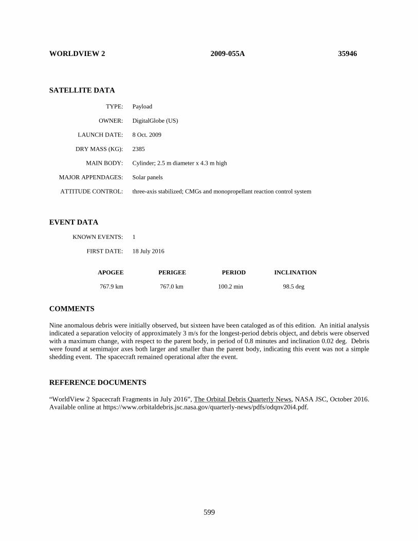
599
WORLDVIEW 2 2009-055A 35946 SATELLITE DATA TYPE: Payload OWNER: DigitalGlobe (US) LAUNCH DATE: 8 Oct. 2009 DRY MASS (KG): 2385 MAIN BODY: Cylinder; 2.5 m diameter x 4.3 m high MAJOR APPENDAGES: Solar panels ATTITUDE CONTROL: three-axis stabilized; CMGs and monopropellant reaction control system EVENT DATA KNOWN EVENTS: 1 FIRST DATE: 18 July 2016 APOGEE PERIGEE PERIOD INCLINATION 767.9 km 767.0 km 100.2 min 98.5 deg COMMENTS Nine anomalous debris were initially observed, but sixteen have been cataloged as of this edition. An initial analysis indicated a separation velocity of approximately 3 m/s for the longest-period debris object, and debris were observed with a maximum change, with respect to the parent body, in period of 0.8 minutes and inclination 0.02 deg. Debris were found at semimajor axes both larger and smaller than the parent body, indicating this event was not a simple shedding event. The spacecraft remained operational after the event. REFERENCE DOCUMENTS “WorldView 2 Spacecraft Fragments in July 2016”, The Orbital Debris Quarterly News, NASA JSC, October 2016. Available online at https://www.orbitaldebris.jsc.nasa.gov/quarterly-news/pdfs/odqnv20i4.pdf.

600
HAIYANG 2A 2011-043A 37781 SATELLITE DATA TYPE: Payload OWNER: PRC LAUNCH DATE: 15 August 2011 DRY MASS (KG): 1500? MAIN BODY: Box, 3 m x 2 m x 2 m? MAJOR APPENDAGES: one solar array ATTITUDE CONTROL: Unknown at time of event EVENT DATA KNOWN EVENTS: 2 FIRST DATE: 6-7 July 2014 APOGEE PERIGEE PERIOD INCLINATION 969 km 967 km 100.4 min 99.4 deg COMMENTS Four pieces of debris were produced from these events, of which three entered the catalog. All three of the cataloged debris had reentered by 15 December 2014 indicating relatively large area-to-mass ratios. This spacecraft uses the CAST 968 bus; however, actual physical parameters are highly uncertain. REFERENCE DOCUMENT “Three Additional Breakups Mar 2014”, The Orbital Debris Quarterly News, NASA JSC, October 2014. Available online at https://orbitaldebris.jsc.nasa.gov/quarterly-news/pdfs/odqnv18i4.pdf.
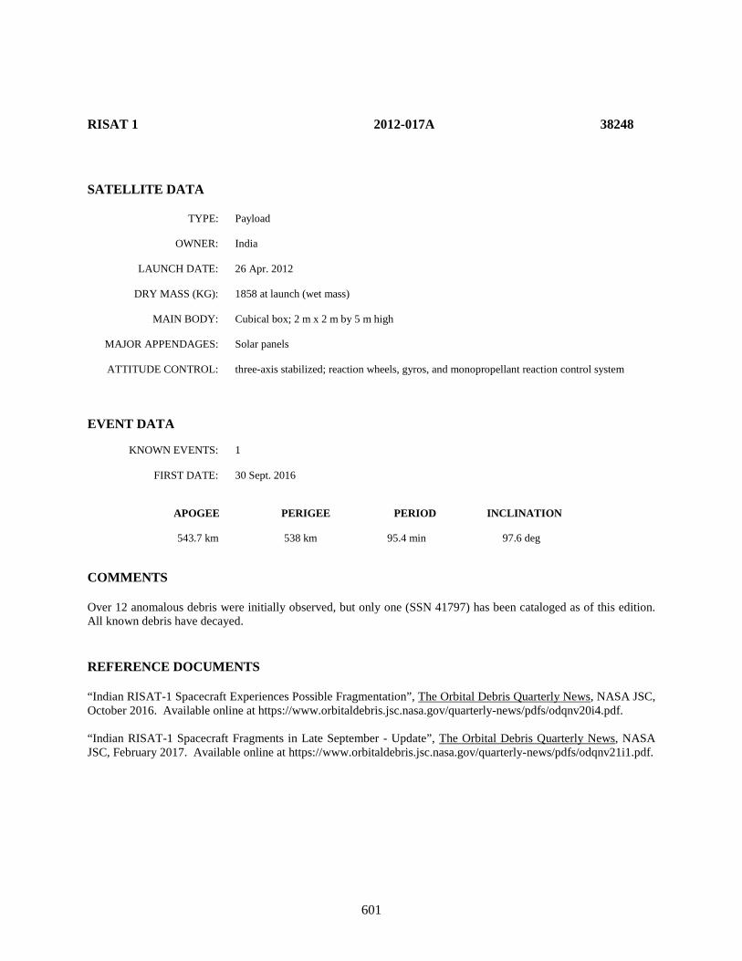
601
RISAT 1 2012-017A 38248 SATELLITE DATA TYPE: Payload OWNER: India LAUNCH DATE: 26 Apr. 2012 DRY MASS (KG): 1858 at launch (wet mass) MAIN BODY: Cubical box; 2 m x 2 m by 5 m high MAJOR APPENDAGES: Solar panels ATTITUDE CONTROL: three-axis stabilized; reaction wheels, gyros, and monopropellant reaction control system EVENT DATA KNOWN EVENTS: 1 FIRST DATE: 30 Sept. 2016 APOGEE PERIGEE PERIOD INCLINATION 543.7 km 538 km 95.4 min 97.6 deg COMMENTS Over 12 anomalous debris were initially observed, but only one (SSN 41797) has been cataloged as of this edition. All known debris have decayed. REFERENCE DOCUMENTS “Indian RISAT-1 Spacecraft Experiences Possible Fragmentation”, The Orbital Debris Quarterly News, NASA JSC, October 2016. Available online at https://www.orbitaldebris.jsc.nasa.gov/quarterly-news/pdfs/odqnv20i4.pdf. “Indian RISAT-1 Spacecraft Fragments in Late September - Update”, The Orbital Debris Quarterly News, NASA JSC, February 2017. Available online at https://www.orbitaldebris.jsc.nasa.gov/quarterly-news/pdfs/odqnv21i1.pdf.

602
BRIZ-KM R/B 2015-020E 40556 SATELLITE DATA TYPE: rocket body OWNER: CIS LAUNCH DATE: 31 Mar. 2015 DRY MASS (KG): 1220 MAIN BODY: Cylinder; 2.5 m diameter by 2.6 m length MAJOR APPENDAGES: None ATTITUDE CONTROL: None at time of event EVENT DATA KNOWN EVENTS: 1 DATE: 29 Apr. 2015 APOGEE PERIGEE PERIOD INCLINATION 1342.5 km 1339.2 km 112.5 min 82.5 deg

603
This Page Intentionally Left Blank
604
4.0 OTHER SATELLITES ASSOCIATED WITH FRAGMENTATIONS
4.1 Aerodynamic Associations with Fragmentation Events Aerodynamic breakups are associated with the breakup of a resident space object caused by interacting with Earth’s atmosphere. Forty such events have occurred between 1994 and July 2018. Because of the orbit elements of the parent object at the time of fragmentation, only seven of these events showed any cataloged debris and all parent objects reentered within 1 year of the event (most reentered within a few days). It is understood that only a fraction of these fragmentations can be detected, because of the short remaining life of the parent and debris created. These events have no impact to the mid- or long-term debris environment and therefore, it was deemed more appropriate to separate these from the fragmentations in Chapter 2. The parent object for these aerodynamic events shall not be considered “fragmentation debris” when discussing object categorization. As mentioned, seven of these events produced cataloged debris other than the parent, and these debris objects represent the difference between the decayed fragmentation debris count in Table 1.3.2 and the decayed fragmentation debris count in Tables 2.1 and 2.2. The following missions, listed by international designator in Table 4.1-1 and by event date in 4.1-2, have been determined to be solely related to aerodynamic effects at the time of reentry and therefore, did not contribute to the orbital environment. Note that the tables strictly interpret cataloging; in the case of there being no cataloged debris there were one to multiple objects observed and decayed prior to entry into the public satellite catalog.
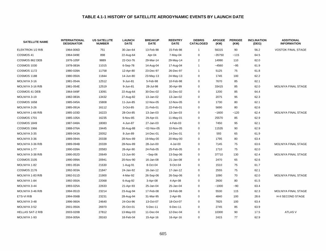
TABLE 4.1-1 HISTORY OF SATELLITE AERODYNAMIC EVENTS BY LAUNCH DATE
605
SATELLITE NAME INTERNATIONAL DESIGNATOR
US SATELLITE NUMBER
LAUNCH DATE
BREAKUP DATE
REENTRY DATE
DEBRIS CATALOGED
APOGEE (KM)
PERIGEE (KM)
INCLINATION (DEG)
ADDITIONAL INFORMATION
ELEKTRON 1/2 R/B 1964-006D 751 30-Jan-64 13-Feb-98 15-Feb-98 1 56315 90 56.2 VOSTOK FINAL STAGE
COSMOS 41 1964-049E 898 22-Aug-64 Apr-04 7-May-04 0 ~35750 ~115 64.5
COSMOS 862 DEB 1976-105F 9889 22-Oct-76 29-Mar-14 29-May-14 2 14990 110 62.0
COSMOS 1030 1978-083A 11015 6-Sep-78 14-Aug-04 17-Aug-04 1 ~4560 ~95 61.9
COSMOS 1172 1980-028A 11758 12-Apr-80 23-Dec-97 26-Dec-97 1 5125 75 61.8
COSMOS 1188 1980-050A 11844 14-Jun-80 23-May-13 24-May-13 0 1745 100 62.2
MOLNIYA 3-16 1981-054A 12512 9-Jun-81 5-Feb-98 10-Feb-98 0 7670 85 62.1
MOLNIYA 3-16 R/B 1981-054E 12519 9-Jun-81 28-Jul-98 30-Apr-99 0 33415 85 62.0 MOLNIYA FINAL STAGE
COSMOS 41 DEB 1964-049F 13091 22-Aug-64 30-Dec-02 31-Dec-02 0 1200 85 64.4
MOLNIYA 3-19 1982-083A 13432 27-Aug-82 13-Jan-02 13-Jan-02 0 2075 95 62.3
COSMOS 1658 1985-045A 15808 11-Jun-85 12-Nov-05 12-Nov-05 0 1730 80 62.1
MOLNIYA 3-26 1985-091A 16112 3-Oct-85 21-Feb-01 22-Feb-01 0 5690 80 62.6
MOLNIYA 1-66 R/B 1985-103D 16223 28-Oct-85 13-Jan-03 13-Jan-03 0 ~1600 ~120 62.4 MOLNIYA FINAL STAGE
COSMOS 1701 1985-105A 16235 9-Nov-85 29-Apr-01 11-May-01 0 25570 85 62.9
COSMOS 1849 1987-048A 18083 4-Jun-87 27-Jan-03 4-Feb-03 0 7450 95 62.1
COSMOS 1966 1988-076A 19445 30-Aug-88 ~02-Nov-05 10-Nov-05 0 11535 90 62.9
MOLNIYA 3-35 1989-043A 20052 8-Jun-89 14-Dec-01 14-Dec-01 0 593 65 61.9
MOLNIYA 3-36 1989-094A 20338 28-Nov-89 19-May-00 20-May-00 0 1795 80 63.4
MOLNIYA 3-36 R/B 1989-094B 20339 28-Nov-89 28-Jun-00 4-Jul-00 0 7145 75 63.6 MOLNIYA FINAL STAGE
MOLNIYA 1-77 1990-039A 20583 26-Apr-90 24-Feb-05 25-Feb-05 0 1710 75 62.0
MOLNIYA 3-38 R/B 1990-052D 20649 13-Jun-90 ~Sep-06 13-Sep-06 0 37710 130 62.4 MOLNIYA FINAL STAGE
COSMOS 2105 1990-099A 20941 20-Nov-90 16-Jan-08 21-Jan-08 0 2470 65 62.6
MOLNIYA 1-82 1991-053A 21630 1-Aug-91 8-Oct-04 9-Oct-04 0 1510 75 61.7
COSMOS 2176 1992-003A 21847 24-Jan-92 16-Jan-12 17-Jan-12 0 2555 75 62.1
MOLNIYA 1-83 R/B 1992-011D 21900 4-Mar-92 26-Sep-06 26-Sep-06 0 1090 70 62.0 MOLNIYA FINAL STAGE
MOLNIYA 1-84 1992-050A 22068 6-Aug-92 3-Apr-08 4-Apr-08 0 2600 80 61.5
MOLNIYA 3-44 1993-025A 22633 21-Apr-93 25-Jan-04 25-Jan-04 0 ~1000 ~90 63.4
MOLNIYA 3-46 R/B 1994-051D 23214 23-Aug-94 17-Feb-08 19-Feb-08 0 5530 115 62.3 MOLNIYA FINAL STAGE
ETS-VI R/B 1994-056B 23231 28-Aug-94 31-Mar-95 2-Apr-95 0 4840 100 28.6 H-II SECOND STAGE
MOLNIYA 3-48 1996-060A 24640 24-Oct-96 13-Oct-07 18-Oct-07 0 7825 100 63.4
MOLNIYA 3-52 2001-050A 26970 25-Oct-01 5-Dec-11 6-Dec-11 0 2745 85 63.9
HELLAS SAT-2 R/B 2003-020B 27812 13-May-03 11-Dec-04 12-Dec-04 0 10300 90 17.5 ATLAS V
MOLNIYA 1-93 2004-005A 28163 18-Feb-04 15-Apr-16 16-Apr-16 0 2415 77 62.9
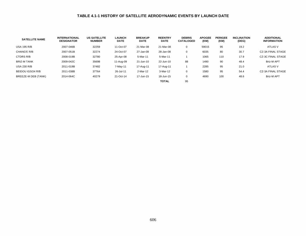
TABLE 4.1-1 HISTORY OF SATELLITE AERODYNAMIC EVENTS BY LAUNCH DATE
606
SATELLITE NAME INTERNATIONAL DESIGNATOR
US SATELLITE NUMBER
LAUNCH DATE
BREAKUP DATE
REENTRY DATE
DEBRIS CATALOGED
APOGEE (KM)
PERIGEE (KM)
INCLINATION (DEG)
ADDITIONAL INFORMATION
USA 195 R/B 2007-046B 32259 11-Oct-07 21-Mar-08 21-Mar-08 0 59015 95 19.2 ATLAS V
CHANG'E R/B 2007-051B 32274 24-Oct-07 27-Jan-08 28-Jan-08 0 6035 80 30.7 CZ-3A FINAL STAGE
CTDRS R/B 2008-019B 32780 25-Apr-08 5-Mar-11 5-Mar-11 1 1065 110 17.9 CZ-3C FINAL STAGE
BRIZ-M TANK 2009-042C 35698 11-Aug-09 21-Jun-10 22-Jun-10 88 1490 90 48.4 Briz-M APT
USA 230 R/B 2011-019B 37482 7-May-11 17-Aug-11 17-Aug-11 1 2285 95 21.0 ATLAS V
BEIDOU IGSO4 R/B 2011-038B 37764 26-Jul-11 2-Mar-12 3-Mar-12 0 1580 95 54.4 CZ-3A FINAL STAGE
BREEZE-M DEB (TANK) 2014-064C 40279 21-Oct-14 17-Jun-15 18-Jun-15 0 4690 100 48.6 Briz-M APT TOTAL 95
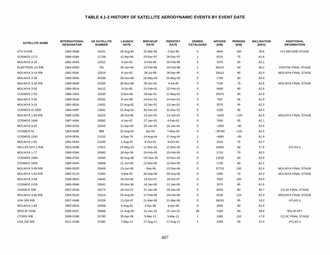
TABLE 4.1-2 HISTORY OF SATELLITE AERODYNAMIC EVENTS BY EVENT DATE
607
SATELLITE NAME INTERNATIONAL DESIGNATOR
US SATELLITE NUMBER
LAUNCH DATE
BREAKUP DATE
REENTRY DATE
DEBRIS CATALOGED
APOGEE (KM)
PERIGEE (KM)
INCLINATION (DEG)
ADDITIONAL INFORMATION
ETS-VI R/B 1994-056B 23231 28-Aug-94 31-Mar-95 2-Apr-95 0 4840 100 28.6 H-II SECOND STAGE
COSMOS 1172 1980-028A 11758 12-Apr-80 23-Dec-97 26-Dec-97 1 5125 75 61.8
MOLNIYA 3-16 1981-054A 12512 9-Jun-81 5-Feb-98 10-Feb-98 0 7670 85 62.1
ELEKTRON 1/2 R/B 1964-006D 751 30-Jan-64 13-Feb-98 15-Feb-98 1 56315 90 56.2 VOSTOK FINAL STAGE
MOLNIYA 3-16 R/B 1981-054E 12519 9-Jun-81 28-Jul-98 30-Apr-99 0 33415 85 62.0 MOLNIYA FINAL STAGE
MOLNIYA 3-36 1989-094A 20338 28-Nov-89 19-May-00 20-May-00 0 1795 80 63.4
MOLNIYA 3-36 R/B 1989-094B 20339 28-Nov-89 28-Jun-00 4-Jul-00 0 7145 75 63.6 MOLNIYA FINAL STAGE
MOLNIYA 3-26 1985-091A 16112 3-Oct-85 21-Feb-01 22-Feb-01 0 5690 80 62.6
COSMOS 1701 1985-105A 16235 9-Nov-85 29-Apr-01 11-May-01 0 25570 85 62.9
MOLNIYA 3-35 1989-043A 20052 8-Jun-89 14-Dec-01 14-Dec-01 0 593 65 61.9
MOLNIYA 3-19 1982-083A 13432 27-Aug-82 13-Jan-02 13-Jan-02 0 2075 95 62.3
COSMOS 41 DEB 1964-049F 13091 22-Aug-64 30-Dec-02 31-Dec-02 0 1200 85 64.4
MOLNIYA 1-66 R/B 1985-103D 16223 28-Oct-85 13-Jan-03 13-Jan-03 0 ~1600 ~120 62.4 MOLNIYA FINAL STAGE
COSMOS 1849 1987-048A 18083 4-Jun-87 27-Jan-03 4-Feb-03 0 7450 95 62.1
MOLNIYA 3-44 1993-025A 22633 21-Apr-93 25-Jan-04 25-Jan-04 0 ~1000 ~90 63.4
COSMOS 41 1964-049E 898 22-Aug-64 Apr-04 7-May-04 0 ~35750 ~115 64.5
COSMOS 1030 1978-083A 11015 6-Sep-78 14-Aug-04 17-Aug-04 1 ~4560 ~95 61.9
MOLNIYA 1-82 1991-053A 21630 1-Aug-91 8-Oct-04 9-Oct-04 0 1510 75 61.7
HELLAS SAT-2 R/B 2003-020B 27812 13-May-03 11-Dec-04 12-Dec-04 0 10300 90 17.5 ATLAS V
MOLNIYA 1-77 1990-039A 20583 26-Apr-90 24-Feb-05 25-Feb-05 0 1710 75 62.0
COSMOS 1966 1988-076A 19445 30-Aug-88 ~02-Nov-05 10-Nov-05 0 11535 90 62.9
COSMOS 1658 1985-045A 15808 11-Jun-85 12-Nov-05 12-Nov-05 0 1730 80 62.1
MOLNIYA 3-38 R/B 1990-052D 20649 13-Jun-90 ~Sep-06 13-Sep-06 0 37710 130 62.4 MOLNIYA FINAL STAGE
MOLNIYA 1-83 R/B 1992-011D 21900 4-Mar-92 26-Sep-06 26-Sep-06 0 1090 70 62.0 MOLNIYA FINAL STAGE
MOLNIYA 3-48 1996-060A 24640 24-Oct-96 13-Oct-07 18-Oct-07 0 7825 100 63.4
COSMOS 2105 1990-099A 20941 20-Nov-90 16-Jan-08 21-Jan-08 0 2470 65 62.6
CHANG'E R/B 2007-051B 32274 24-Oct-07 27-Jan-08 28-Jan-08 0 6035 80 30.7 CZ-3A FINAL STAGE
MOLNIYA 3-46 R/B 1994-051D 23214 23-Aug-94 17-Feb-08 19-Feb-08 0 5530 115 62.3 MOLNIYA FINAL STAGE
USA 195 R/B 2007-046B 32259 11-Oct-07 21-Mar-08 21-Mar-08 0 59015 95 19.2 ATLAS V
MOLNIYA 1-84 1992-050A 22068 6-Aug-92 3-Apr-08 4-Apr-08 0 2600 80 61.5
BRIZ-M TANK 2009-042C 35698 11-Aug-09 21-Jun-10 22-Jun-10 88 1490 90 48.4 Briz-M APT
CTDRS R/B 2008-019B 32780 25-Apr-08 5-Mar-11 5-Mar-11 1 1065 110 17.9 CZ-3C FINAL STAGE
USA 230 R/B 2011-019B 37482 7-May-11 17-Aug-11 17-Aug-11 1 2285 95 21.0 ATLAS V
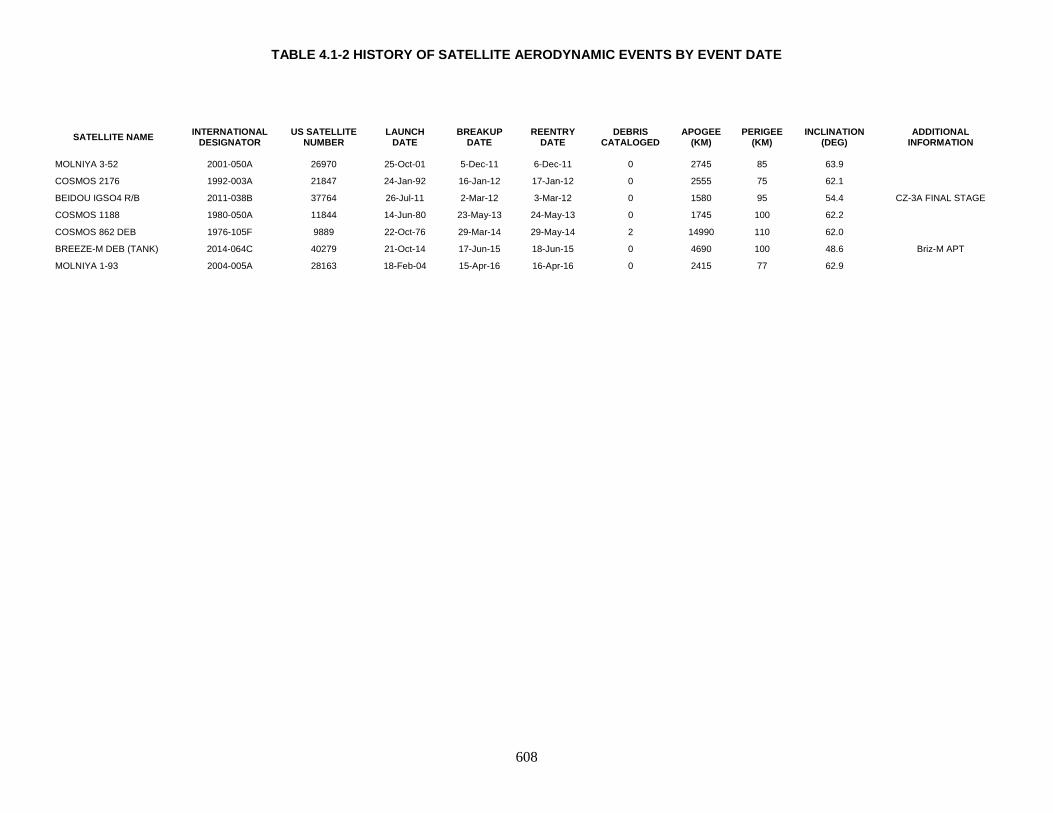
TABLE 4.1-2 HISTORY OF SATELLITE AERODYNAMIC EVENTS BY EVENT DATE
608
SATELLITE NAME INTERNATIONAL DESIGNATOR
US SATELLITE NUMBER
LAUNCH DATE
BREAKUP DATE
REENTRY DATE
DEBRIS CATALOGED
APOGEE (KM)
PERIGEE (KM)
INCLINATION (DEG)
ADDITIONAL INFORMATION
MOLNIYA 3-52 2001-050A 26970 25-Oct-01 5-Dec-11 6-Dec-11 0 2745 85 63.9
COSMOS 2176 1992-003A 21847 24-Jan-92 16-Jan-12 17-Jan-12 0 2555 75 62.1
BEIDOU IGSO4 R/B 2011-038B 37764 26-Jul-11 2-Mar-12 3-Mar-12 0 1580 95 54.4 CZ-3A FINAL STAGE
COSMOS 1188 1980-050A 11844 14-Jun-80 23-May-13 24-May-13 0 1745 100 62.2
COSMOS 862 DEB 1976-105F 9889 22-Oct-76 29-Mar-14 29-May-14 2 14990 110 62.0
BREEZE-M DEB (TANK) 2014-064C 40279 21-Oct-14 17-Jun-15 18-Jun-15 0 4690 100 48.6 Briz-M APT
MOLNIYA 1-93 2004-005A 28163 18-Feb-04 15-Apr-16 16-Apr-16 0 2415 77 62.9
609
This Page Intentionally Left Blank

610
4.2 Reactor Coolant Debris The Soviet Union conducted the Radar Ocean Reconnaissance satellite (RORSAT) program with developmental and operational flights spanning 1965 (Cosmos 102) to 1988 (Cosmos 1932). Starting with Cosmos 198 (1967) large operational debris objects were left in their operational orbit while the nuclear reactor power source was boosted to a higher storage (or “graveyard”) orbit. Beginning with Cosmos 1176 (1980) RORSATs routinely ejected their reactor core. This practice resulted in the venting of all or part of the reactor’s Sodium-Potassium (NaK) liquid metal coolant. This population is largely undetectable by the sensors of the Space Surveillance Network (SSN). However, some coolant of sufficient size to be detected by at least some sensors has been cataloged by the SSN. Table 4.2 lists the coolant objects cataloged as of 4 July 2018.
TABLE 4.2: CATALOGED RORSAT PROGRAM NAK COOLANT DEBRIS
international designator common name
Total coolant
cataloged
coolant on-
orbit 1976-103 COSMOS 860 3 3 1980-034 COSMOS 1176 2 2 1981-021 COSMOS 1249 17 17 1981-037 COSMOS 1266 1 1 1982-099 COSMOS 1412 1 1 1984-069 COSMOS 1579 31 31 1987-011 COSMOS 1818* 29 29 1987-060 COSMOS 1867* 40 40
*not operational RORSAT program element; discussed in Section 3.
4.3 Spurious Associations with Fragmentation Events Satellite fragmentation lists compiled by other organizations, in particular by the National Security Council and NAVSPASUR, were carefully reviewed during the preparation of the fourth edition of the History of On-Orbit Satellite Fragmentations. However, due to the frequent exchange of information within the small orbital debris and space operations community and the long period during which satellite fragmentation lists have been maintained, no current list is completely independent from all others. These reviews also revealed the need to define better the terms "satellite breakup" and "anomalous event" as discussed in Section 1.0. Many "breakup" lists have historically included entries related to normal launch and mission activities which resulted in numbers of debris in excess of the handful usually observed on these occasions. Some researchers have been misled by tracking difficulties and cataloging procedures that may cause late cataloging or misidentification of debris, superficially giving the appearance of fragmentations. A higher than average number of debris alone is not sufficient to assume a satellite fragmentation. Such pitfalls can generally be avoided
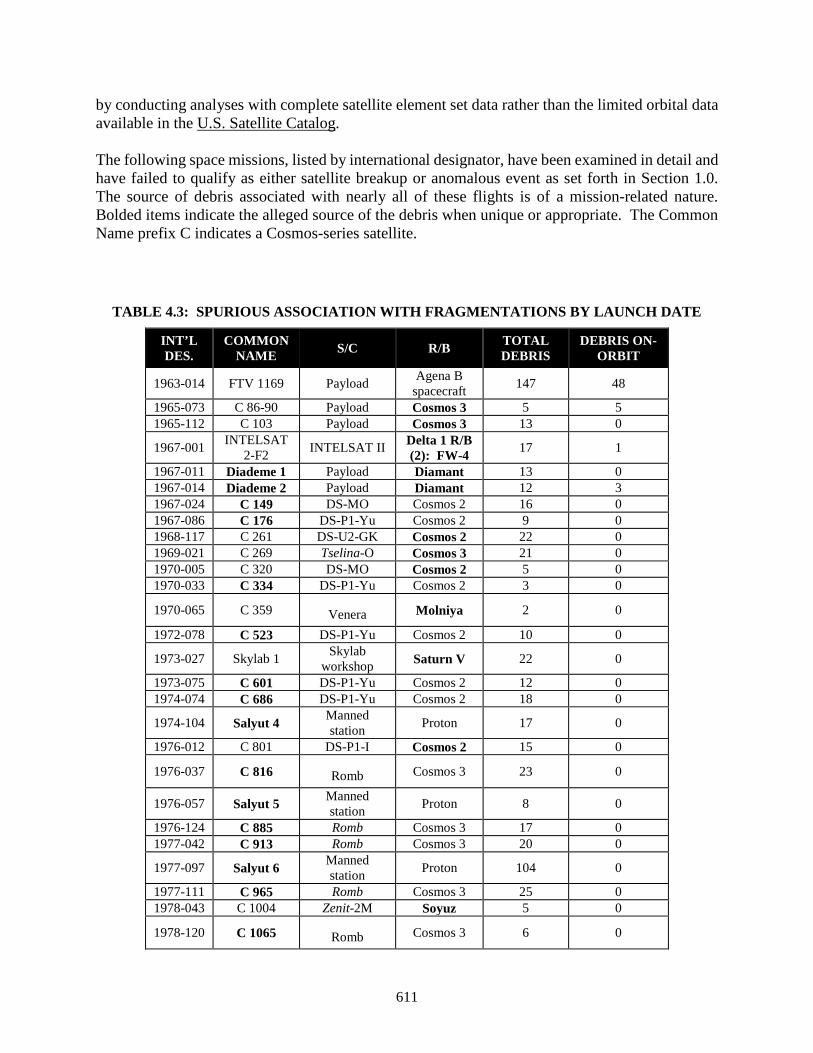
611
by conducting analyses with complete satellite element set data rather than the limited orbital data available in the U.S. Satellite Catalog. The following space missions, listed by international designator, have been examined in detail and have failed to qualify as either satellite breakup or anomalous event as set forth in Section 1.0. The source of debris associated with nearly all of these flights is of a mission-related nature. Bolded items indicate the alleged source of the debris when unique or appropriate. The Common Name prefix C indicates a Cosmos-series satellite.
TABLE 4.3: SPURIOUS ASSOCIATION WITH FRAGMENTATIONS BY LAUNCH DATE
INT’L DES.
COMMON NAME S/C R/B TOTAL
DEBRIS DEBRIS ON-
ORBIT
1963-014 FTV 1169 Payload Agena B spacecraft 147 48
1965-073 C 86-90 Payload Cosmos 3 5 5 1965-112 C 103 Payload Cosmos 3 13 0
1967-001 INTELSAT 2-F2 INTELSAT II Delta 1 R/B
(2): FW-4 17 1
1967-011 Diademe 1 Payload Diamant 13 0 1967-014 Diademe 2 Payload Diamant 12 3 1967-024 C 149 DS-MO Cosmos 2 16 0 1967-086 C 176 DS-P1-Yu Cosmos 2 9 0 1968-117 C 261 DS-U2-GK Cosmos 2 22 0 1969-021 C 269 Tselina-O Cosmos 3 21 0 1970-005 C 320 DS-MO Cosmos 2 5 0 1970-033 C 334 DS-P1-Yu Cosmos 2 3 0
1970-065 C 359 Venera Molniya 2 0
1972-078 C 523 DS-P1-Yu Cosmos 2 10 0
1973-027 Skylab 1 Skylab workshop Saturn V 22 0
1973-075 C 601 DS-P1-Yu Cosmos 2 12 0 1974-074 C 686 DS-P1-Yu Cosmos 2 18 0
1974-104 Salyut 4 Manned station Proton 17 0
1976-012 C 801 DS-P1-I Cosmos 2 15 0
1976-037 C 816 Romb Cosmos 3 23 0
1976-057 Salyut 5 Manned station Proton 8 0
1976-124 C 885 Romb Cosmos 3 17 0 1977-042 C 913 Romb Cosmos 3 20 0
1977-097 Salyut 6 Manned station Proton 104 0
1977-111 C 965 Romb Cosmos 3 25 0 1978-043 C 1004 Zenit-2M Soyuz 5 0
1978-120 C 1065 Romb Cosmos 3 6 0
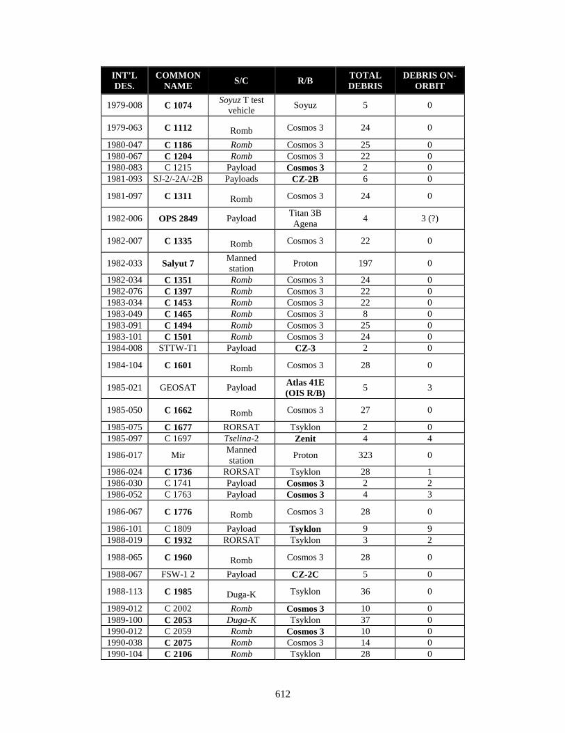
612
INT’L DES.
COMMON NAME S/C R/B TOTAL
DEBRIS DEBRIS ON-
ORBIT
1979-008 C 1074 Soyuz T test vehicle Soyuz 5 0
1979-063 C 1112 Romb Cosmos 3 24 0
1980-047 C 1186 Romb Cosmos 3 25 0 1980-067 C 1204 Romb Cosmos 3 22 0 1980-083 C 1215 Payload Cosmos 3 2 0 1981-093 SJ-2/-2A/-2B Payloads CZ-2B 6 0
1981-097 C 1311 Romb Cosmos 3 24 0
1982-006 OPS 2849 Payload Titan 3B Agena 4 3 (?)
1982-007 C 1335 Romb Cosmos 3 22 0
1982-033 Salyut 7 Manned station Proton 197 0
1982-034 C 1351 Romb Cosmos 3 24 0 1982-076 C 1397 Romb Cosmos 3 22 0 1983-034 C 1453 Romb Cosmos 3 22 0 1983-049 C 1465 Romb Cosmos 3 8 0 1983-091 C 1494 Romb Cosmos 3 25 0 1983-101 C 1501 Romb Cosmos 3 24 0 1984-008 STTW-T1 Payload CZ-3 2 0
1984-104 C 1601 Romb Cosmos 3 28 0
1985-021 GEOSAT Payload Atlas 41E (OIS R/B) 5 3
1985-050 C 1662 Romb Cosmos 3 27 0
1985-075 C 1677 RORSAT Tsyklon 2 0 1985-097 C 1697 Tselina-2 Zenit 4 4
1986-017 Mir Manned station Proton 323 0
1986-024 C 1736 RORSAT Tsyklon 28 1 1986-030 C 1741 Payload Cosmos 3 2 2 1986-052 C 1763 Payload Cosmos 3 4 3
1986-067 C 1776 Romb Cosmos 3 28 0
1986-101 C 1809 Payload Tsyklon 9 9 1988-019 C 1932 RORSAT Tsyklon 3 2
1988-065 C 1960 Romb Cosmos 3 28 0
1988-067 FSW-1 2 Payload CZ-2C 5 0
1988-113 C 1985 Duga-K Tsyklon 36 0
1989-012 C 2002 Romb Cosmos 3 10 0 1989-100 C 2053 Duga-K Tsyklon 37 0 1990-012 C 2059 Romb Cosmos 3 10 0 1990-038 C 2075 Romb Cosmos 3 14 0 1990-104 C 2106 Romb Tsyklon 28 0
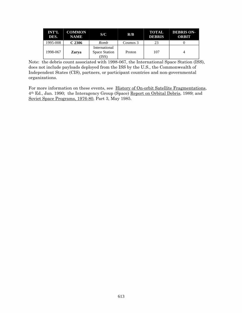
613
INT’L DES.
COMMON NAME S/C R/B TOTAL
DEBRIS DEBRIS ON-
ORBIT 1995-008 C 2306 Romb Cosmos 3 23 0
1998-067 Zarya International Space Station
(ISS) Proton 107 4
Note: the debris count associated with 1998-067, the International Space Station (ISS), does not include payloads deployed from the ISS by the U.S., the Commonwealth of Independent States (CIS), partners, or participant countries and non-governmental organizations. For more information on these events, see History of On-orbit Satellite Fragmentations, 4th Ed., Jan. 1990; the Interagency Group (Space) Report on Orbital Debris, 1989; and Soviet Space Programs, 1976-80, Part 3, May 1985.
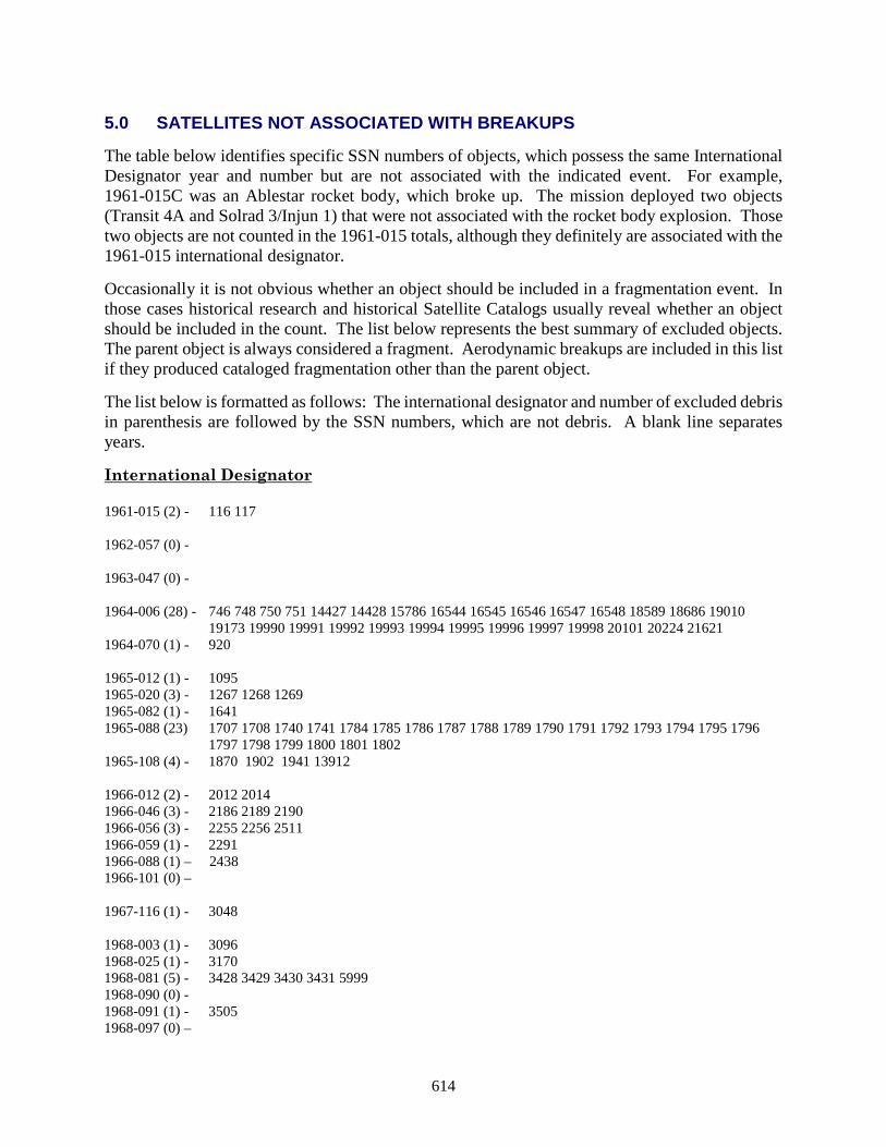
614
5.0 SATELLITES NOT ASSOCIATED WITH BREAKUPS The table below identifies specific SSN numbers of objects, which possess the same International Designator year and number but are not associated with the indicated event. For example, 1961-015C was an Ablestar rocket body, which broke up. The mission deployed two objects (Transit 4A and Solrad 3/Injun 1) that were not associated with the rocket body explosion. Those two objects are not counted in the 1961-015 totals, although they definitely are associated with the 1961-015 international designator. Occasionally it is not obvious whether an object should be included in a fragmentation event. In those cases historical research and historical Satellite Catalogs usually reveal whether an object should be included in the count. The list below represents the best summary of excluded objects. The parent object is always considered a fragment. Aerodynamic breakups are included in this list if they produced cataloged fragmentation other than the parent object. The list below is formatted as follows: The international designator and number of excluded debris in parenthesis are followed by the SSN numbers, which are not debris. A blank line separates years. International Designator 1961-015 (2) - 116 117 1962-057 (0) - 1963-047 (0) - 1964-006 (28) - 746 748 750 751 14427 14428 15786 16544 16545 16546 16547 16548 18589 18686 19010
19173 19990 19991 19992 19993 19994 19995 19996 19997 19998 20101 20224 21621 1964-070 (1) - 920 1965-012 (1) - 1095 1965-020 (3) - 1267 1268 1269 1965-082 (1) - 1641 1965-088 (23) 1707 1708 1740 1741 1784 1785 1786 1787 1788 1789 1790 1791 1792 1793 1794 1795 1796
1797 1798 1799 1800 1801 1802 1965-108 (4) - 1870 1902 1941 13912 1966-012 (2) - 2012 2014 1966-046 (3) - 2186 2189 2190 1966-056 (3) - 2255 2256 2511 1966-059 (1) - 2291 1966-088 (1) – 2438 1966-101 (0) – 1967-116 (1) - 3048 1968-003 (1) - 3096 1968-025 (1) - 3170 1968-081 (5) - 3428 3429 3430 3431 5999 1968-090 (0) - 1968-091 (1) - 3505 1968-097 (0) –
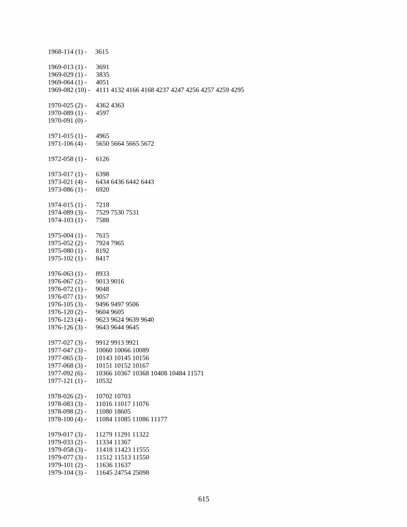
615
1968-114 (1) - 3615 1969-013 (1) - 3691 1969-029 (1) - 3835 1969-064 (1) - 4051 1969-082 (10) - 4111 4132 4166 4168 4237 4247 4256 4257 4259 4295 1970-025 (2) - 4362 4363 1970-089 (1) - 4597 1970-091 (0) - 1971-015 (1) - 4965 1971-106 (4) - 5650 5664 5665 5672 1972-058 (1) - 6126 1973-017 (1) - 6398 1973-021 (4) - 6434 6436 6442 6443 1973-086 (1) - 6920 1974-015 (1) - 7218 1974-089 (3) - 7529 7530 7531 1974-103 (1) - 7588 1975-004 (1) - 7615 1975-052 (2) - 7924 7965 1975-080 (1) - 8192 1975-102 (1) - 8417 1976-063 (1) - 8933 1976-067 (2) - 9013 9016 1976-072 (1) - 9048 1976-077 (1) - 9057 1976-105 (3) - 9496 9497 9506 1976-120 (2) - 9604 9605 1976-123 (4) - 9623 9624 9639 9640 1976-126 (3) - 9643 9644 9645 1977-027 (3) - 9912 9913 9921 1977-047 (3) - 10060 10066 10089 1977-065 (3) - 10143 10145 10156 1977-068 (3) - 10151 10152 10167 1977-092 (6) - 10366 10367 10368 10408 10484 11571 1977-121 (1) - 10532 1978-026 (2) - 10702 10703 1978-083 (3) - 11016 11017 11076 1978-098 (2) - 11080 18605 1978-100 (4) - 11084 11085 11086 11177 1979-017 (3) - 11279 11291 11322 1979-033 (2) - 11334 11367 1979-058 (3) - 11418 11423 11555 1979-077 (3) - 11512 11513 11550 1979-101 (2) - 11636 11637 1979-104 (3) - 11645 24754 25098
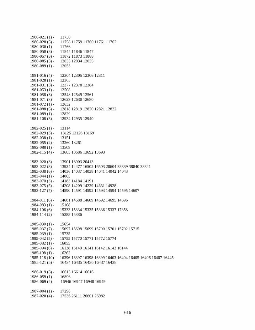
616
1980-021 (1) - 11730 1980-028 (5) - 11758 11759 11760 11761 11762 1980-030 (1) - 11766 1980-050 (3) - 11845 11846 11847 1980-057 (3) - 11872 11873 11888 1980-085 (3) - 12033 12034 12035 1980-089 (1) - 12055 1981-016 (4) - 12304 12305 12306 12311 1981-028 (1) - 12365 1981-031 (3) - 12377 12378 12384 1981-053 (1) - 12508 1981-058 (3) - 12548 12549 12561 1981-071 (3) - 12629 12630 12680 1981-072 (1) - 12632 1981-088 (5) - 12818 12819 12820 12821 12822 1981-089 (1) - 12829 1981-108 (3) - 12934 12935 12940 1982-025 (1) - 13114 1982-029 (3) - 13125 13126 13169 1982-038 (1) - 13151 1982-055 (2) - 13260 13261 1982-088 (1) - 13509 1982-115 (4) - 13685 13686 13692 13693 1983-020 (3) - 13901 13903 20413 1983-022 (8) - 13924 14477 16502 16503 28604 38839 38840 38841 1983-038 (6) - 14036 14037 14038 14041 14042 14043 1983-044 (1) - 14065 1983-070 (3) - 14183 14184 14191 1983-075 (5) - 14208 14209 14229 14631 14928 1983-127 (7) - 14590 14591 14592 14593 14594 14595 14607 1984-011 (6) - 14681 14688 14689 14692 14695 14696 1984-083 (1) - 15168 1984-106 (6) - 15333 15334 15335 15336 15337 17358 1984-114 (2) - 15385 15386 1985-030 (1) - 15654 1985-037 (7) - 15697 15698 15699 15700 15701 15702 15715 1985-039 (1) - 15735 1985-042 (5) - 15755 15770 15771 15772 15774 1985-082 (1) - 16055 1985-094 (6) - 16138 16140 16141 16142 16143 16144 1985-108 (1) - 16262 1985-118 (10) - 16396 16397 16398 16399 16403 16404 16405 16406 16407 16445 1985-121 (5) - 16434 16435 16436 16437 16438 1986-019 (3) - 16613 16614 16616 1986-059 (1) - 16896 1986-069 (4) - 16946 16947 16948 16949 1987-004 (1) - 17298 1987-020 (4) - 17536 26111 26601 26982

617
1987-059 (2) - 18185 18186 1987-062 (1) - 18215 1987-068 (1) - 18312 1987-078 (3) - 18350 18351 18353 1987-079 (6) - 18355 18356 18357 18358 18359 18360 1987-108 (1) - 18714 1987-109 (5) - 18715 18716 18717 18718 18722 1988-005 (3) - 18821 38540 38543 1988-006 (4) - 18845 18846 18855 18984 1988-007 (1) - 18824 1988-023 (1) - 18986 1988-040 (1) - 19121 1988-085 (6) - 19501 19502 19503 19504 19505 21751 1988-109 (3) - 19687 19688 19690 1989-001 (6) - 19749 19750 19751 19752 19753 19754 1989-004 (5) - 19765 19766 19767 19768 19776 1989-006 (1) - 19772 1989-039 (7) - 20024 20025 20026 20027 20028 20044 20082 1989-052 (5) - 20107 20108 20109 20110 20115 1989-054 (1) - 20125 1989-056 (2) - 20137 20138 1989-089 (79) - 20322 20324 20328 22625 22683 22695 22747 22748 22749 22750 22751 22752 22753 22754
22755 22756 22757 22758 22759 22760 22761 22762 22763 22764 22765 22766 22767 22768 22769 22770 22771 22772 22773 22774 22775 22776 22820 22852 22853 22854 22855 22856 22857 22858 22972 23053 23054 23055 23056 23057 23058 23059 23060 23061 23062 23063 23064 23065 23066 23067 23068 23069 23070 23071 23072 23073 23074 23075 23076 23077 23078 23079 23080 23081 23082 23083 23084 23085 23086
1989-100 (38) - 20389 20397 20398 20408 20467 20468 20515 20522 20531 20532 20637 20640 20802 20803 20821 20822 20823 20911 21020 21021 21022 21023 21042 21043 21064 21205 21206 21207 21537 21540 21767 21768 21769 21770 21771 21772 21773 21774
1989-101 (6) - 20391 20392 20393 20394 20400 21648 1990-045 (5) - 20619 20620 20621 20622 20623 1990-081 (7) - 20788 20789 20790 20792 20793 20797 20798 1990-087 (1) - 20829 1990-102 (5) - 20953 20954 20955 20958 21046 1990-105 (1) - 20978 1990-110 (6) - 21006 21007 21008 21009 21010 21011 1991-003 (3) - 21055 21056 21058 1991-009 (8) - 21100 21101 21102 21103 21104 21105 21106 21107 1991-010 (5) - 21111 21112 21113 21122 21129 1991-015 (4) - 21139 21140 21142 21904 1991-025 (6) - 21216 21217 21218 21219 21220 21221 1991-068 (6) - 21728 21729 21730 21731 21732 21733 1991-071 (1) - 21742 1991-075 (1) - 21765 1991-082 (4) 21800 21801 21825 21836 1992-021 (3) - 21939 21940 21942 1992-041 (8) - 22027 22028 22033 27484 27485 27486 27487 27675 1992-047 (6) - 22056 22057 22058 22059 22060 22061 1992-082 (5) - 22245 22246 22247 22248 22249 1992-088 (5) - 22269 22270 22271 22272 22273

618
1992-091 (1) - 22281 1992-093 (5) - 22284 22290 22291 22292 22293 1993-016 (3) - 22565 22575 22576 1993-018 (1) - 22586 1993-028 (1) - 22642 1993-036 (3) - 22676 23007 25028 1993-045 (1) - 22717 1993-057 (2) - 22790 22953 1993-072 (5) - 22907 22908 22909 22910 22926 1994-004 (2) - 22973 22987 1994-029 (1) - 23105 1994-038 (5) - 23168 23169 23170 23171 23172 1994-069 (5) - 23327 23328 23329 23330 23339 1994-076 (7) - 23396 23397 23398 23399 23400 23401 23403 1994-085 (1) - 23439 1995-015 (4) - 23534 23535 23594 23595 1995-028 (1) - 23597 1995-033 (3) - 23605 23607 23608 1995-037 (9) - 23620 23621 23622 23623 23624 23625 23626 23627 23630 1996-010 (5) - 23794 23795 23796 23824 24736 1996-034 (5) - 23880 23881 23882 23883 23886 1997-024 (1) - 24806 1997-051 (7) - 24944 24945 24947 24948 24949 24950 24951 1997-070 (5) - 25045 25046 25047 25048 25053 1997-079 (1) - 25089 1997-086 (3) - 25126 25127 25128 1998-011 (1) - 25175 1999-008 (3) - 25634 25635 25636 1999-025 (5) - 25731 25732 25733 37580 37581 1999-057 (1) - 25941 1999-072 (1) - 26041 2000-036 (5) - 26394 26395 26396 26397 26399 2000-055 (1) - 27477 2001-049 (3) - 26957 26958 26959 2001-057 (1) - 27054 2002-037 (6) - 27470 27471 27472 27473 27476 27494 2003-035 (6) - 27857 28084 28085 28086 28087 28088 2006-002 (1) - 28931 2006-006 (1) - 28943 2006-015 (5) - 29093 29536 29537 29538 29539 2006-026 (1) - 29248 2006-037 (4) - 29393 29395 29396 29493 2006-039 (2) - 29397 29403 2006-050 (5) - 29522 29524 29525 29600 29637
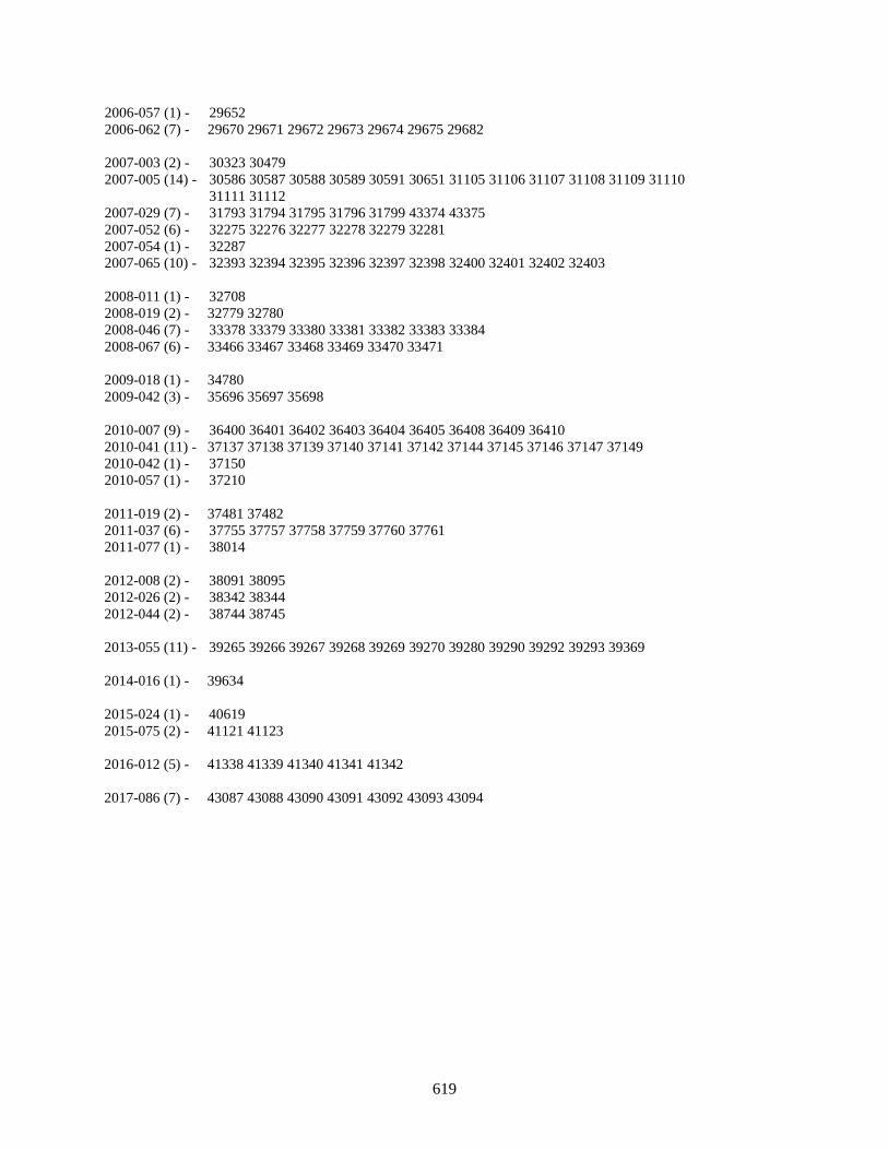
619
2006-057 (1) - 29652 2006-062 (7) - 29670 29671 29672 29673 29674 29675 29682 2007-003 (2) - 30323 30479 2007-005 (14) - 30586 30587 30588 30589 30591 30651 31105 31106 31107 31108 31109 31110 31111 31112 2007-029 (7) - 31793 31794 31795 31796 31799 43374 43375 2007-052 (6) - 32275 32276 32277 32278 32279 32281 2007-054 (1) - 32287 2007-065 (10) - 32393 32394 32395 32396 32397 32398 32400 32401 32402 32403 2008-011 (1) - 32708 2008-019 (2) - 32779 32780 2008-046 (7) - 33378 33379 33380 33381 33382 33383 33384 2008-067 (6) - 33466 33467 33468 33469 33470 33471 2009-018 (1) - 34780 2009-042 (3) - 35696 35697 35698 2010-007 (9) - 36400 36401 36402 36403 36404 36405 36408 36409 36410 2010-041 (11) - 37137 37138 37139 37140 37141 37142 37144 37145 37146 37147 37149 2010-042 (1) - 37150 2010-057 (1) - 37210 2011-019 (2) - 37481 37482 2011-037 (6) - 37755 37757 37758 37759 37760 37761 2011-077 (1) - 38014 2012-008 (2) - 38091 38095 2012-026 (2) - 38342 38344 2012-044 (2) - 38744 38745 2013-055 (11) - 39265 39266 39267 39268 39269 39270 39280 39290 39292 39293 39369 2014-016 (1) - 39634 2015-024 (1) - 40619 2015-075 (2) - 41121 41123 2016-012 (5) - 41338 41339 41340 41341 41342 2017-086 (7) - 43087 43088 43090 43091 43092 43093 43094

620
6.0 SATELLITES NOT ASSOCIATED WITH ANOMALOUS EVENTS The table below identifies specific SSN numbers of objects, which possess the same International Designator year and number but are not associated with the indicated anomalous event. The list below represents the best summary of excluded objects. Parent object is not considered a fragment. The list below is formatted as follows: The international designator and number of excluded debris in parenthesis are followed by the SSN numbers that are not debris. International Designator 1959-007 (1) - 20 1963-049 (12) - 703 704 705 706 715 753 2432 2620 2930 4586 6182 6283 1964-006 (5) - 746 748 750 751 25278 1964-026 (5) - 801 805 806 809 2986 1964-053 (2) - 876 877 1965-016 (9) - 1208 1244 1245 1271 1272 1291 1292 1293 1310 1965-027 (3) - 1314 1315 1316 1965-048 (6) - 1420 1425 1428 1435 2701 3592 1965-098 (10) - 1804 1806 1807 1808 1944 1948 1951 2092 2153 20833 1965-101 (4) - 1814 1815 1934 1935 1965-109 (5) - 1864 1865 2086 2226 2353 1966-005 (6) - 1952 1953 2140 2141 2889 2989 1966-024 (3) - 2119 2120 3590 1966-040 (2) - 2173 2174 1966-077 (3) - 2403 2411 2412 1967-034 (6) - 2754 2755 2777 2778 6718 7670 1967-048 (4) - 2807 2811 17723 19222 1967-092 (4) - 2965 2967 2994 3122 1968-019 (2) - 3150 3151 1969-009 (2) - 3669 3670 1970-067 (5) - 4507 4515 5036 5447 6372 1971-003 (2) - 4849 4850 1972-049 (2) - 6079 6080 1972-102 (2) - 6319 6320 1975-027 (2) - 7734 7735 1978-014 (6) - 10664 10665 12329 12330 12331 12406 1978-064 (1) - 10967 1978-094 (2) - 11055 11056 1978-096 (3) - 11060 11061 11062 1978-098 (2) - 11080 11081
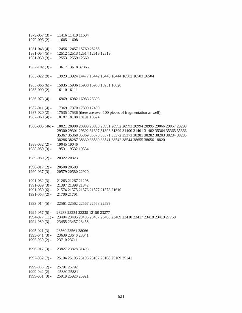
621
1979-057 (3) - 11416 11419 11634 1979-095 (2) - 11605 11608 1981-043 (4) - 12456 12457 15769 25255 1981-054 (5) - 12512 12513 12514 12515 12519 1981-059 (3) - 12553 12559 12560 1982-102 (3) - 13617 13618 37865 1983-022 (9) - 13923 13924 14477 16442 16443 16444 16502 16503 16504 1985-066 (6) - 15935 15936 15938 15950 15951 16020 1985-090 (2) - 16110 16111 1986-073 (4) - 16969 16982 16983 26303 1987-011 (4) - 17369 17370 17399 17400 1987-020 (2) - 17535 17536 (there are over 100 pieces of fragmentation as well) 1987-060 (4) - 18187 18188 18191 18524 1988-005 (46) - 18821 28988 28999 28990 28991 28992 28993 28994 28995 29066 29067 29299 29300 29301 29302 31397 31398 31399 31400 31401 31402 35364 35365 35366 35367 35368 35369 35370 35371 35372 35373 38281 38282 38283 38284 38285 38286 38287 38330 38539 38541 38542 38544 38655 38656 18820 1988-032 (2) - 19045 19046 1988-089 (3) - 19531 19532 19534 1989-089 (2) - 20322 20323 1990-017 (2) - 20508 20509 1990-037 (3) - 20579 20580 22920 1991-032 (3) - 21263 21267 21298 1991-039 (3) - 21397 21398 21842 1991-050 (6) - 21574 21575 21576 21577 21578 21610 1991-063 (2) - 21700 21701 1993-014 (5) - 22561 22562 22567 22568 22599 1994-057 (5) - 23233 23234 23235 12150 23277 1994-077 (11) - 23404 23405 23406 23407 23408 23409 23410 23417 23418 23419 27760 1994-089 (3) - 23455 23457 23458 1995-021 (3) - 23560 23561 28066 1995-041 (3) - 23639 23640 23641 1995-059 (2) - 23710 23711 1996-017 (3) – 23827 23828 31403 1997-082 (7) - 25104 25105 25106 25107 25108 25109 25141 1999-035 (2) - 25791 25792 1999-042 (2) - 25880 25881 1999-051 (3) - 25919 25920 25921
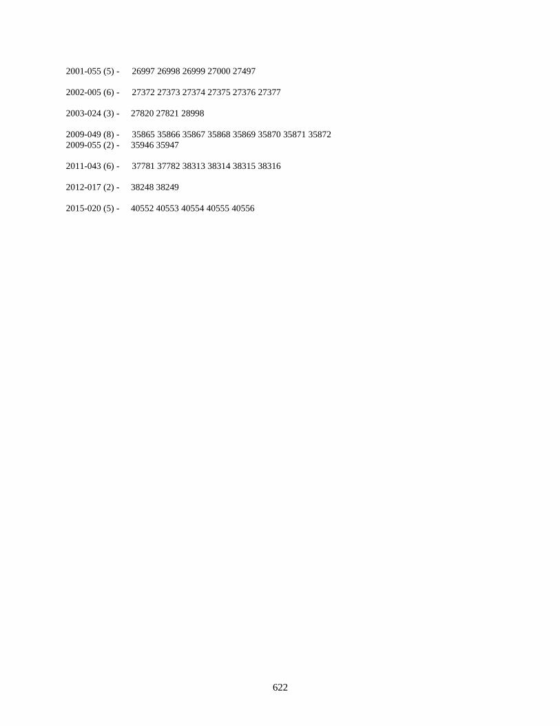
622
2001-055 (5) - 26997 26998 26999 27000 27497 2002-005 (6) - 27372 27373 27374 27375 27376 27377 2003-024 (3) - 27820 27821 28998 2009-049 (8) - 35865 35866 35867 35868 35869 35870 35871 35872 2009-055 (2) - 35946 35947 2011-043 (6) - 37781 37782 38313 38314 38315 38316 2012-017 (2) - 38248 38249 2015-020 (5) - 40552 40553 40554 40555 40556

REPORT DOCUMENTATION PAGE
Standard Form 298 (Rev. 8/98) Prescribed by ANSI Std. Z39.18
Form Approved OMB No. 0704-0188
The public reporting burden for this collection of information is estimated to average 1 hour per response, including the time for reviewing instructions, searching existing data sources, gathering and maintaining the data needed, and completing and reviewing the collection of information. Send comments regarding this burden estimate or any other aspect of this collection of information, including suggestions for reducing the burden, to Department of Defense, Washington Headquarters Services, Directorate for Information Operations and Reports (0704-0188), 1215 Jefferson Davis Highway, Suite 1204, Arlington, VA 22202-4302. Respondents should be aware that notwithstanding any other provision of law, no person shall be subject to any penalty for failing to comply with a collection of information if it does not display a currently valid OMB control number. PLEASE DO NOT RETURN YOUR FORM TO THE ABOVE ADDRESS.
1. REPORT DATE (DD-MM-YYYY) 2. REPORT TYPE 3. DATES COVERED (From - To)
4. TITLE AND SUBTITLE 5a. CONTRACT NUMBER
5b. GRANT NUMBER
5c. PROGRAM ELEMENT NUMBER
5d. PROJECT NUMBER
5e. TASK NUMBER
5f. WORK UNIT NUMBER
6. AUTHOR(S)
7. PERFORMING ORGANIZATION NAME(S) AND ADDRESS(ES) 8. PERFORMING ORGANIZATION REPORT NUMBER
10. SPONSOR/MONITOR'S ACRONYM(S)
11. SPONSOR/MONITOR'S REPORT NUMBER(S)
9. SPONSORING/MONITORING AGENCY NAME(S) AND ADDRESS(ES)
12. DISTRIBUTION/AVAILABILITY STATEMENT
13. SUPPLEMENTARY NOTES
14. ABSTRACT
15. SUBJECT TERMS
16. SECURITY CLASSIFICATION OF:a. REPORT b. ABSTRACT c. THIS PAGE
17. LIMITATION OF ABSTRACT
18. NUMBER OF PAGES
19a. NAME OF RESPONSIBLE PERSON
19b. TELEPHONE NUMBER (Include area code)
11/28/2018 Technical Memorandum Aug - Oct 2018
History of On-Orbit Satellite Fragmentations, 15th edition
Phillip D. Anz-Meador, John N. Opiela, Debra Shoots, and J.-C. Liou
National Aeronautics and Space Administration Lyndon B. Johnson Space Center Houston, Texas 77058
National Aeronautics and Space Administration Washington, DC 20546-0001
NASA
NASA/TM-2018-220037
Available electronically via the NASA Technical Reports server at http://www.ntrs.nasa.gov.
The History of On-Orbit Satellite Fragmentations chronicles all known satellite fragmentation events, this 15th edition complete through a suspense date of 4 July 2018. Since the 14th edition breakups, in addition to launch activity, have resulted in an approximately 36% increase in the number of cataloged space objects. More significantly, breakup and anomalous debris accounted for 65% of the catalog growth observed. The reason for these large increases was the first accidental collision of two intact spacecraft, Iridium 33 and Cosmos 2251, and the continued cataloging of debris created by the intentional destruction of the Fengyun 1C spacecraft-the most environmentally harmful fragmentation to date.
orbital debris; space debris; fragmentations; breakups; anomalous debris; debris environment; Orbital Debris Program Office; ODPO
U U U UU 636