Embed Size (px)
Citation preview
Satellite orbit determination
Astronomical Institute University of Bern
Satellite Orbit Determination
Astronomical Institute University of Bern
Adrian Jäggi
Satellite orbit determination
Astronomical Institute University of Bern
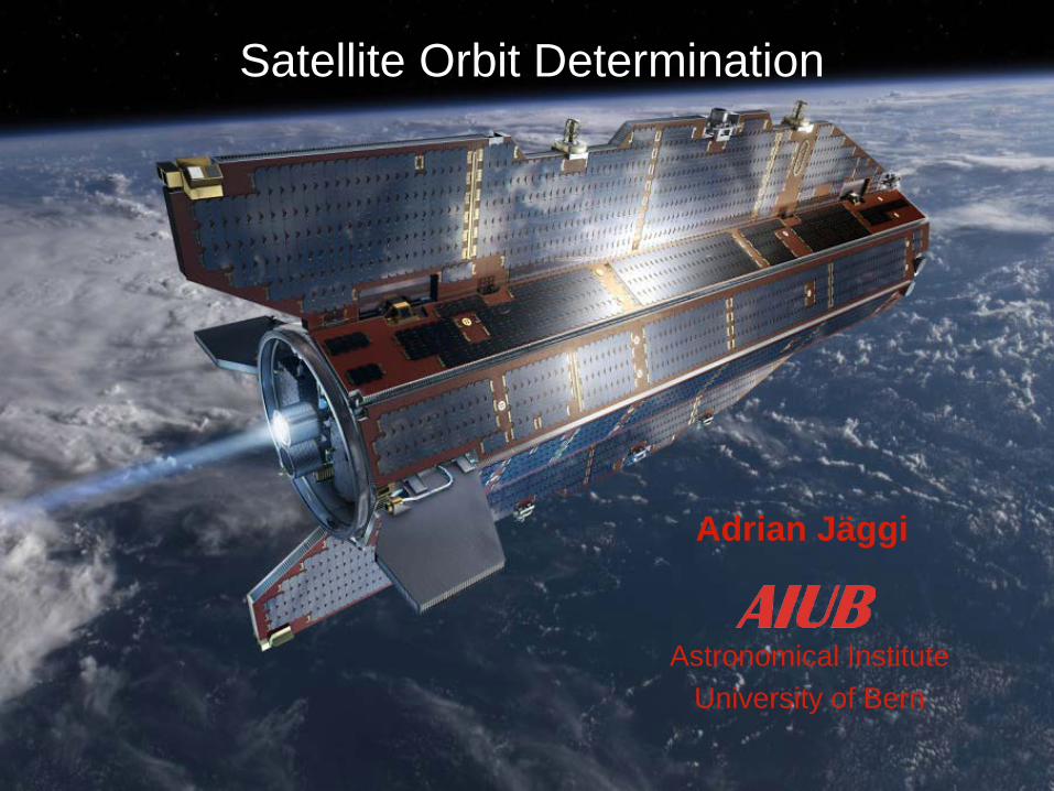
Low Earth Orbiters (LEOs) GRACE GOCE TanDEM-X
Gravity Recovery And Climate Experiment
Gravity and steady-state Ocean Circulation Explorer
TerraSAR-X add-on for Digital Elevation Measurement
Of course, there are many more missions equipped with GPS receivers Jason Jason-2 MetOp-A Icesat COSMIC
Satellite orbit determination
Astronomical Institute University of Bern
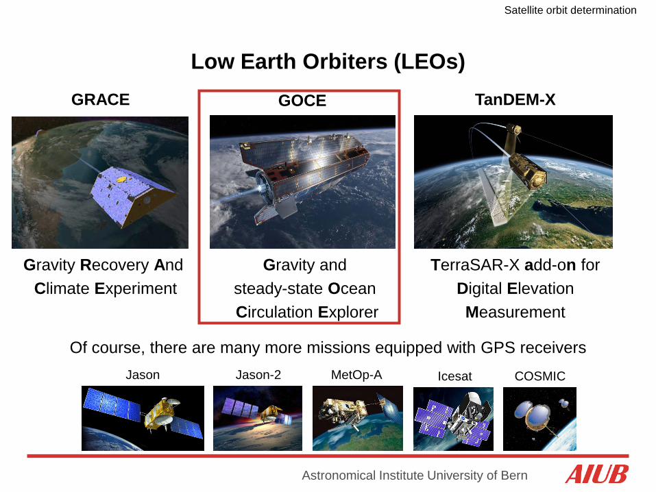
LEO Orbit Characteristics – the example of GOCE
Ground-track coverage on 2 Nov, 2009 Dusk-dawn sun-synchronous orbit (i = 96.6°)
Complete geographical coverage after 979 revolutions (repeat-cycle of 61 days)
Polar gap

Satellite orbit determination
Astronomical Institute University of Bern
Satellite orbit determination
Astronomical Institute University of Bern
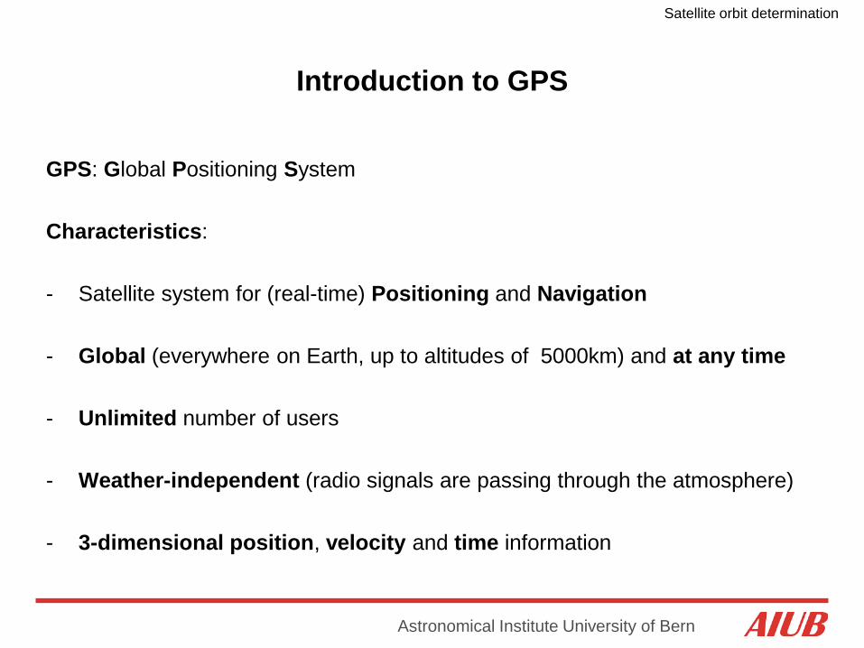
Introduction to GPS
GPS: Global Positioning System Characteristics: - Satellite system for (real-time) Positioning and Navigation - Global (everywhere on Earth, up to altitudes of 5000km) and at any time
- Unlimited number of users
- Weather-independent (radio signals are passing through the atmosphere) - 3-dimensional position, velocity and time information
Satellite orbit determination
Astronomical Institute University of Bern
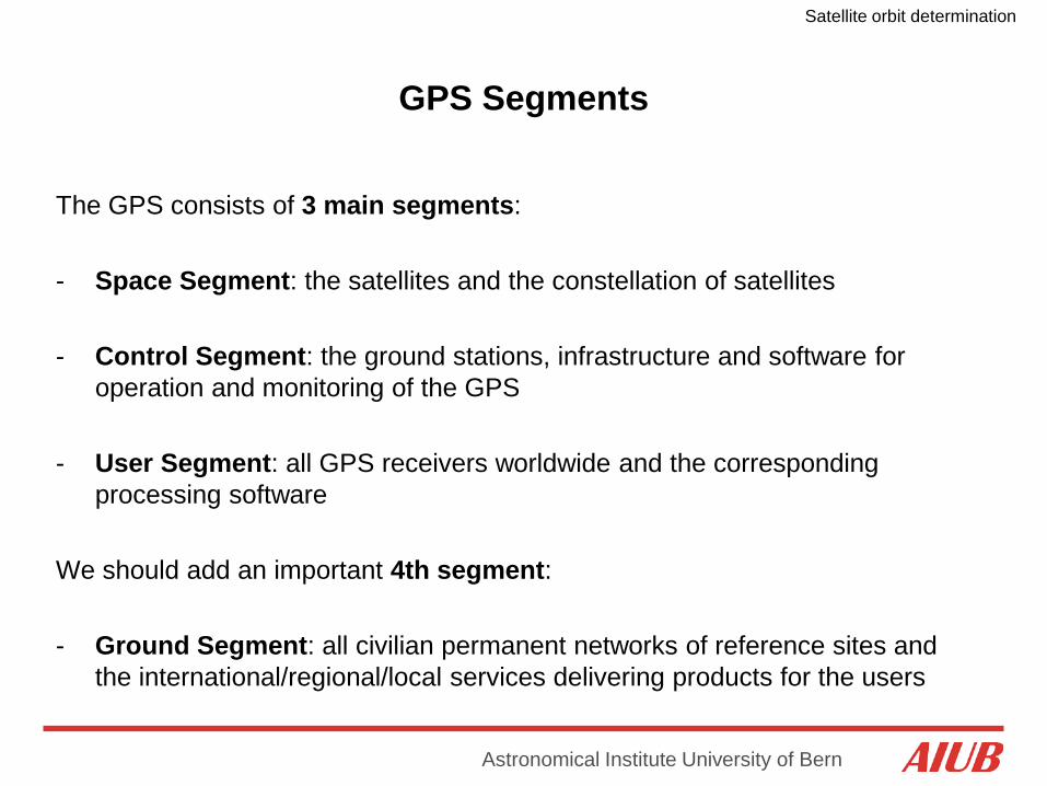
GPS Segments
The GPS consists of 3 main segments: - Space Segment: the satellites and the constellation of satellites
- Control Segment: the ground stations, infrastructure and software for
operation and monitoring of the GPS
- User Segment: all GPS receivers worldwide and the corresponding processing software
We should add an important 4th segment: - Ground Segment: all civilian permanent networks of reference sites and
the international/regional/local services delivering products for the users
Satellite orbit determination
Astronomical Institute University of Bern
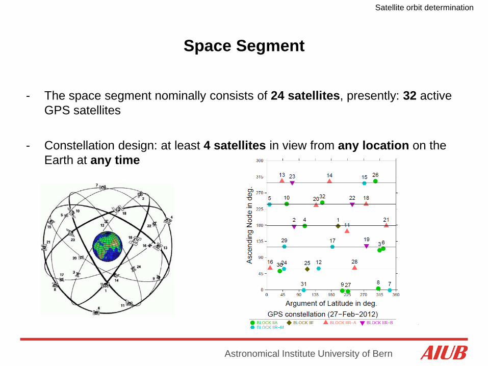
Space Segment
- The space segment nominally consists of 24 satellites, presently: 32 active GPS satellites
- Constellation design: at least 4 satellites in view from any location on the Earth at any time
Satellite orbit determination
Astronomical Institute University of Bern
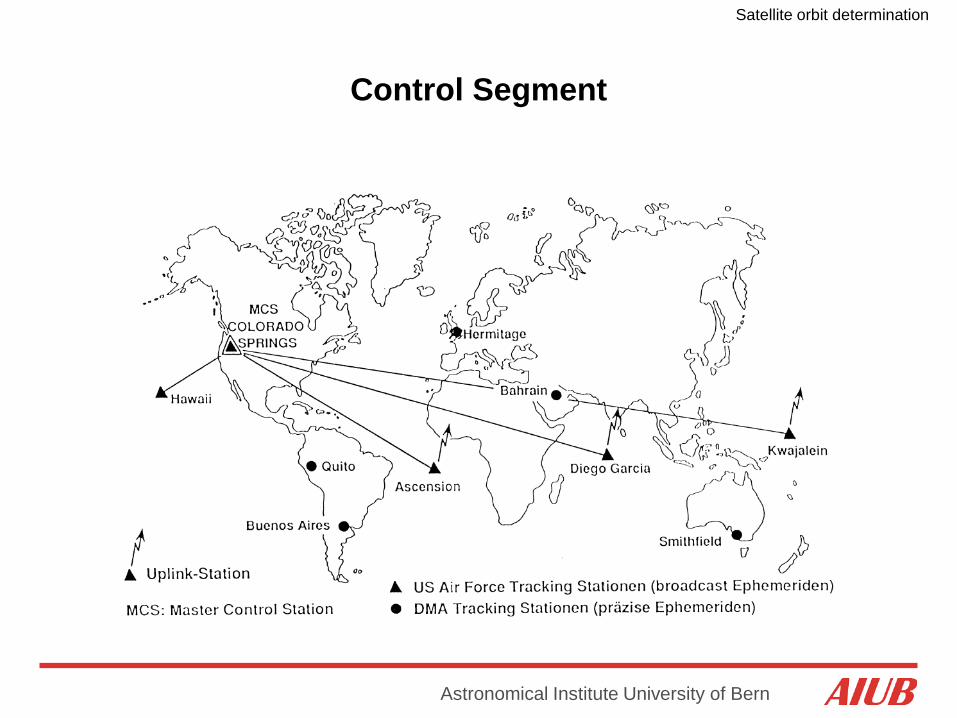
Control Segment
Satellite orbit determination
Astronomical Institute University of Bern
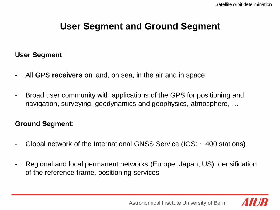
User Segment and Ground Segment
User Segment: - All GPS receivers on land, on sea, in the air and in space
- Broad user community with applications of the GPS for positioning and
navigation, surveying, geodynamics and geophysics, atmosphere, …
Ground Segment: - Global network of the International GNSS Service (IGS: ~ 400 stations)
- Regional and local permanent networks (Europe, Japan, US): densification
of the reference frame, positioning services
Satellite orbit determination
Astronomical Institute University of Bern
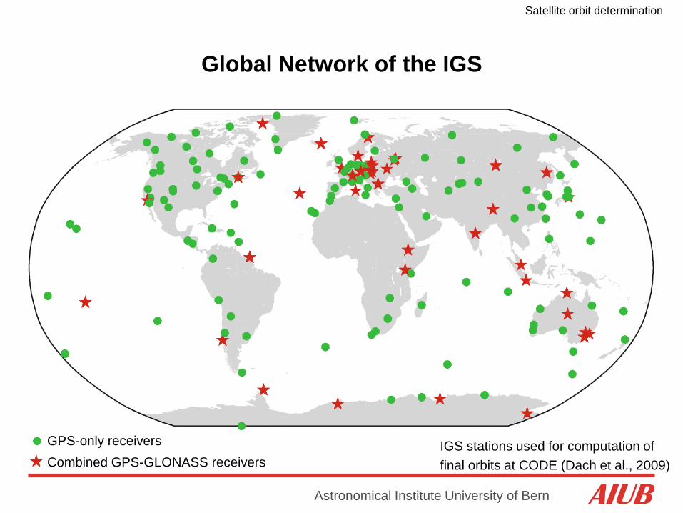
Global Network of the IGS
GPS-only receivers Combined GPS-GLONASS receivers
IGS stations used for computation of final orbits at CODE (Dach et al., 2009)

Satellite orbit determination
Astronomical Institute University of Bern
Global Network of the IGS
IGS stations used for computation of final orbits at CODE (November 2011)
More and more multi-GNSS receivers are available in the global network of the IGS
Satellite orbit determination
Astronomical Institute University of Bern
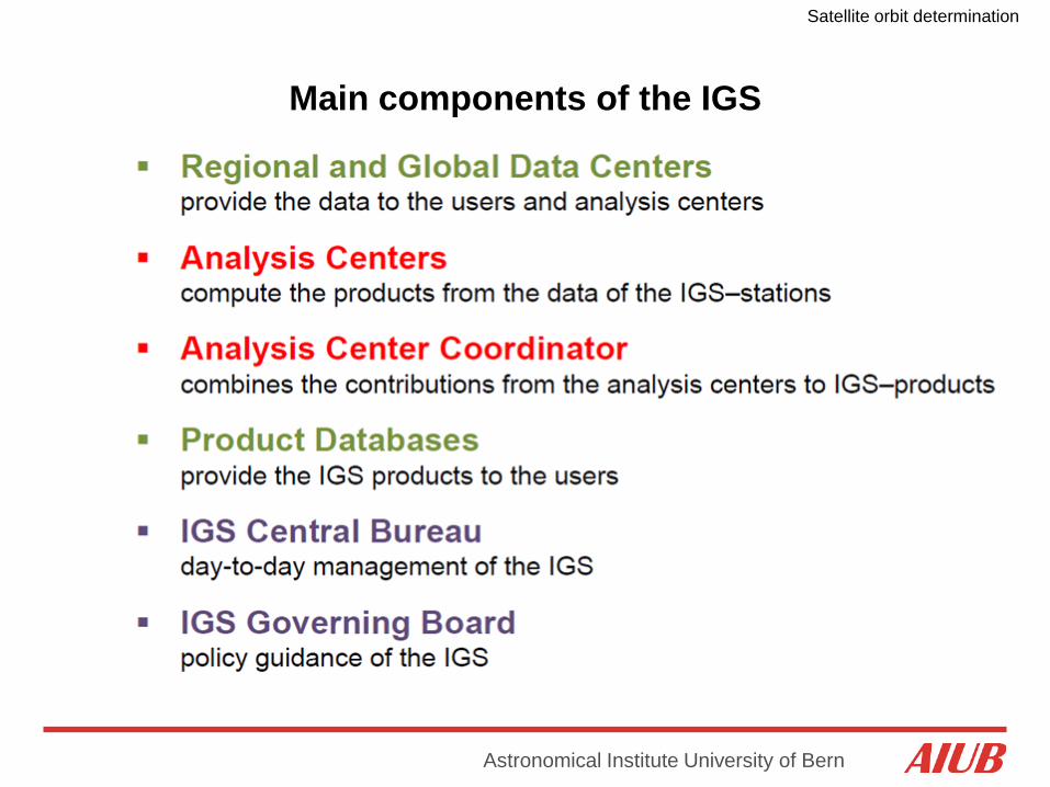
Main components of the IGS

Satellite orbit determination
Astronomical Institute University of Bern
Analysis Centers (ACs) of the IGS
CODE (Center for Orbit Determination in Europe) as an example: CODE is a joint-venture between: - Astronomical Institute of the University of Bern (AIUB), Bern, Switzerland
- Swiss Federal Office of Topography (swisstopo), Wabern, Switzerland
- German Federal Office for Cartography and Geodesy (BKG), Frankfurt, Germany
- Institute of Astronomical and Physical Geodesy (IAPG) of the Technische Universität München (TUM), Munich, Germany
Satellite orbit determination
Astronomical Institute University of Bern
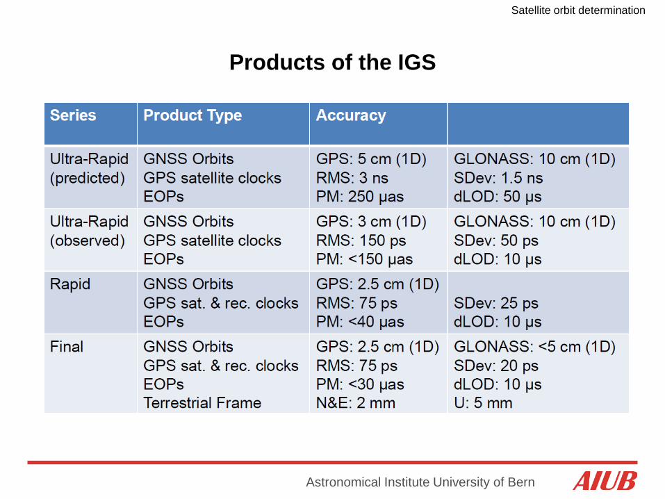
Products of the IGS
Satellite orbit determination
Astronomical Institute University of Bern
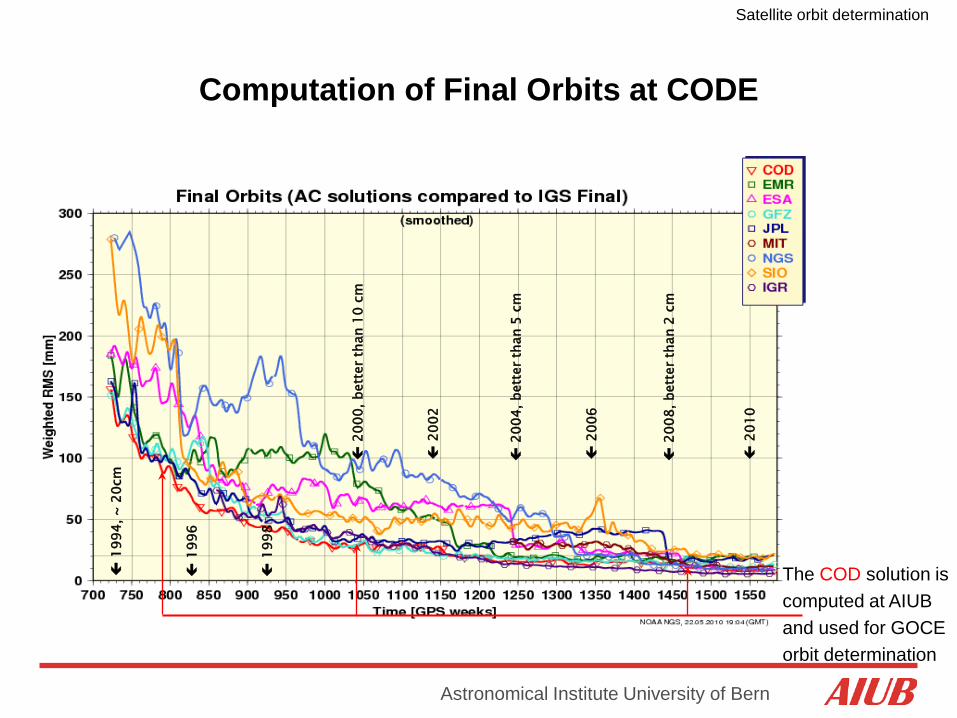
Computation of Final Orbits at CODE
199
4, ~
20c
m
1
996
1
998
2
000,
bet
ter t
han
10 c
m
2
002
2
004,
bet
ter t
han
5 cm
2
010
2
008,
bet
ter t
han
2 cm
2
006
The COD solution is computed at AIUB and used for GOCE orbit determination
Satellite orbit determination
Astronomical Institute University of Bern
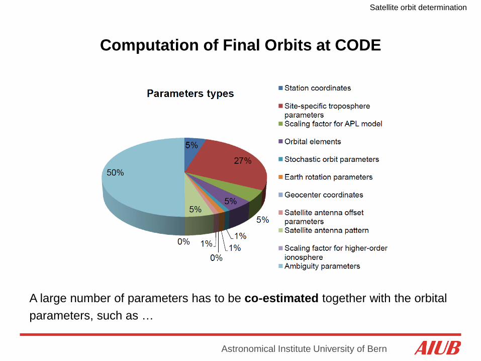
Computation of Final Orbits at CODE
β
A large number of parameters has to be co-estimated together with the orbital parameters, such as …
Satellite orbit determination
Astronomical Institute University of Bern
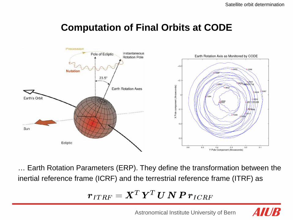
Computation of Final Orbits at CODE
… Earth Rotation Parameters (ERP). They define the transformation between the inertial reference frame (ICRF) and the terrestrial reference frame (ITRF) as

Satellite orbit determination
Astronomical Institute University of Bern
Computation of Final Clocks at CODE
(Bock et al., 2009c)
The final clock product with 5 min sampling is based on undifferenced GPS data of the IGS network
The IGS 1 Hz network is finally used for clock densification to 5 sec The 5 sec clocks are interpolated to 1 sec as needed for GOCE orbit determination
Satellite orbit determination
Astronomical Institute University of Bern
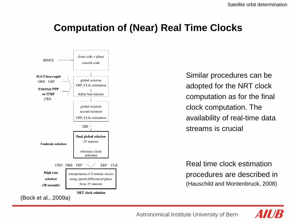
Computation of (Near) Real Time Clocks
(Bock et al., 2009a)
Similar procedures can be adopted for the NRT clock computation as for the final clock computation. The availability of real-time data streams is crucial
Real time clock estimation procedures are described in (Hauschild and Montenbruck, 2008)

Satellite orbit determination
Astronomical Institute University of Bern
GPS Signals
Signals driven by an atomic clock
Two carrier signals (sine waves):
Bits encoded on carrier by phase
- L1: f = 1575.43 MHz, λ = 19 cm - L2: f = 1227.60 MHz, λ = 24 cm
modulation:
- C/A-code (Clear Access / Coarse Acquisition)
- P-code (Protected / Precise) - Broadcast/Navigation Message

Satellite orbit determination
Astronomical Institute University of Bern
Pseudorange / Code Measurements
Code Observations are defined as:
Speed of light (in vacuum)
Receiver clock reading at signal reception (in receiver clock time)
GPS satellite clock reading at signal emission (in satellite clock time)
(Blewitt, 1997)
- No actual „range“ (distance) because of clock offsets
- Measurement noise: ~ 0.5 m for good P-code
Satellite orbit determination
Astronomical Institute University of Bern
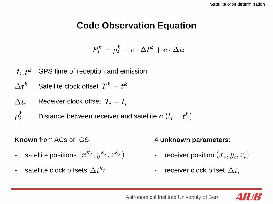
Code Observation Equation
Satellite clock offset
Receiver clock offset
GPS time of reception and emission ,
Distance between receiver and satellite
Known from ACs or IGS:
- satellite positions
- satellite clock offsets
4 unknown parameters:
- receiver position
- receiver clock offset
Satellite orbit determination
Astronomical Institute University of Bern
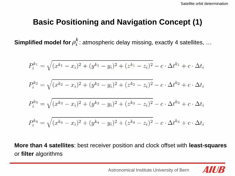
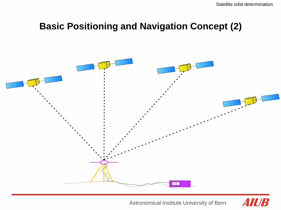
Basic Positioning and Navigation Concept (1)
Simplified model for : atmospheric delay missing, exactly 4 satellites, …
More than 4 satellites: best receiver position and clock offset with least-squares or filter algorithms
Satellite orbit determination
Astronomical Institute University of Bern
Basic Positioning and Navigation Concept (2)

Satellite orbit determination
Astronomical Institute University of Bern
Carrier Phase Measurements (1)
linearly with time Phase (in cycles) increases
:
where is the frequency
The satellite generates with its clock the phase signal . At emmision time (in satellite clock time) we have
The same phase signal, e.g., a wave crest, propagates from the satellite to the receiver, but the receiver measures only the fractional part of the phase and does not know the integer number of cycles (phase ambiguity):
Satellite orbit determination
Astronomical Institute University of Bern
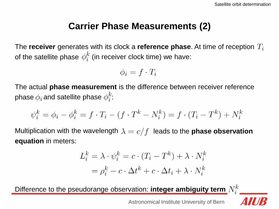
Carrier Phase Measurements (2)
The receiver generates with its clock a reference phase. At time of reception of the satellite phase (in receiver clock time) we have:
The actual phase measurement is the difference between receiver reference phase and satellite phase :
Multiplication with the wavelength equation in meters:
leads to the phase observation
Difference to the pseudorange observation: integer ambiguity term
Satellite orbit determination
Astronomical Institute University of Bern
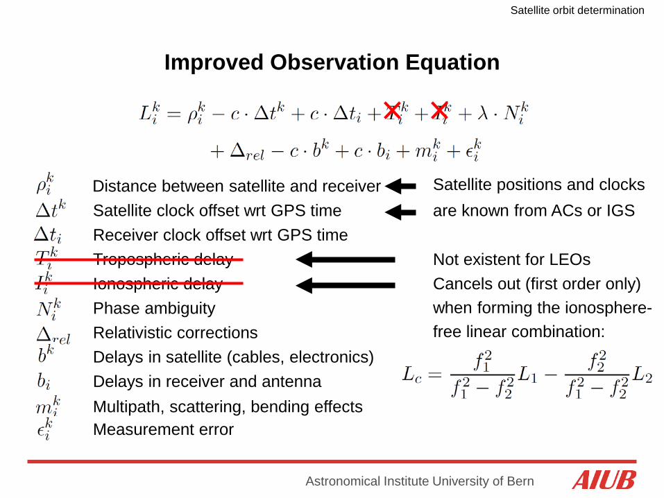
Improved Observation Equation
Tropospheric delay Ionospheric delay Phase ambiguity
Receiver clock offset wrt GPS time
Distance between satellite and receiver Satellite clock offset wrt GPS time
Relativistic corrections Delays in satellite (cables, electronics) Delays in receiver and antenna Multipath, scattering, bending effects Measurement error
Not existent for LEOs Cancels out (first order only) when forming the ionosphere- free linear combination:
are known from ACs or IGS Satellite positions and clocks
Satellite orbit determination
Astronomical Institute University of Bern
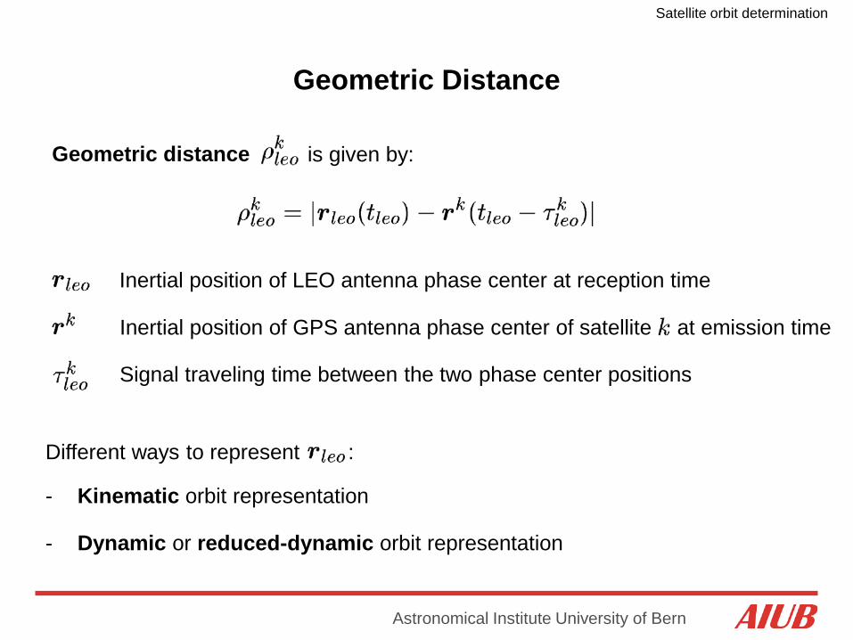
Geometric Distance
at emission time
Geometric distance is given by:
Inertial position of LEO antenna phase center at reception time
Inertial position of GPS antenna phase center of satellite
Signal traveling time between the two phase center positions
Different ways to represent :
- Kinematic orbit representation
- Dynamic or reduced-dynamic orbit representation
Satellite orbit determination
Astronomical Institute University of Bern
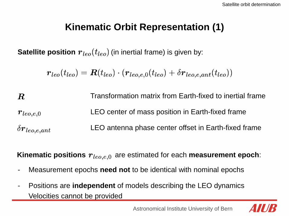
Satellite position (in inertial frame) is given by:
Transformation matrix from Earth-fixed to inertial frame
LEO center of mass position in Earth-fixed frame
LEO antenna phase center offset in Earth-fixed frame
Kinematic Orbit Representation (1)
Kinematic positions
are estimated for each measurement epoch:
- Measurement epochs need not to be identical with nominal epochs
- Positions are independent of models describing the LEO dynamics Velocities cannot be provided

Satellite orbit determination
Astronomical Institute University of Bern
Kinematic Orbit Representation (2)
A kinematic orbit is an ephemeris at discrete measurement epochs
Kinematic positions are fully independent on the force models used for LEO orbit determination (Svehla and Rothacher, 2004)
Kinematic positions are not uncorrelated if phase measurements are used (due to ambiguities)
Satellite orbit determination
Astronomical Institute University of Bern
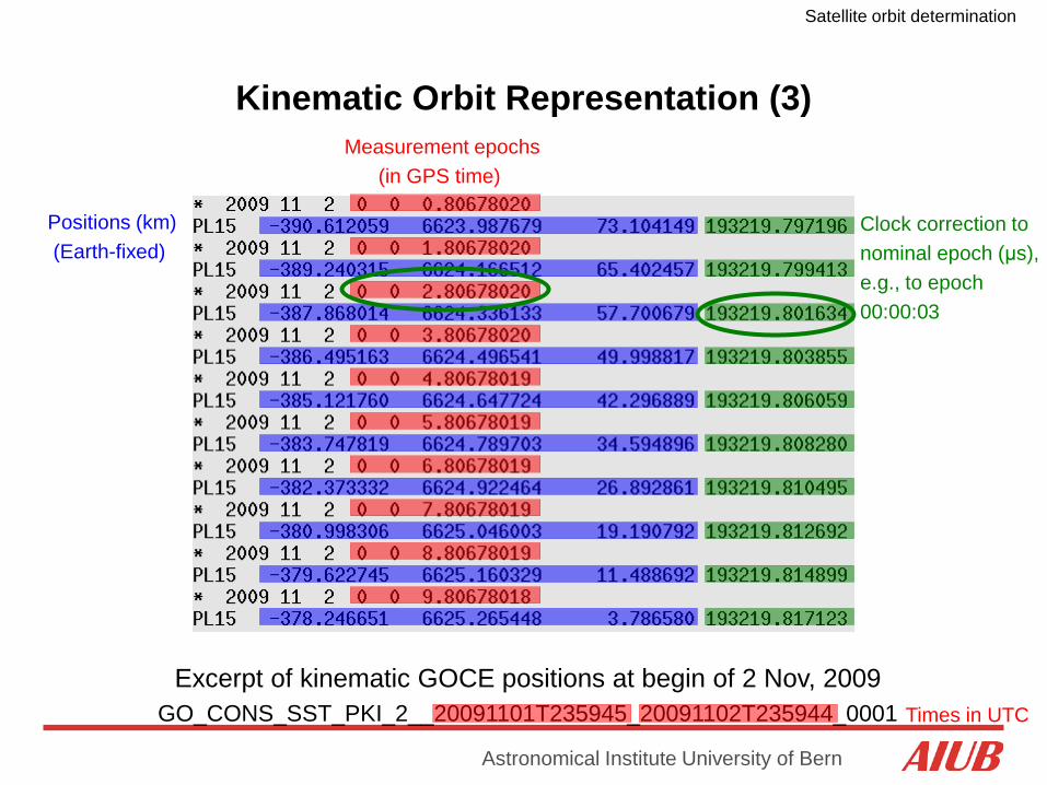
Kinematic Orbit Representation (3)
Excerpt of kinematic GOCE positions at begin of 2 Nov, 2009 GO_CONS_SST_PKI_2__20091101T235945_20091102T235944_0001
Measurement epochs (in GPS time)
Positions (km) (Earth-fixed)
Clock correction to nominal epoch (μs), e.g., to epoch 00:00:03
Times in UTC
Satellite orbit determination
Astronomical Institute University of Bern
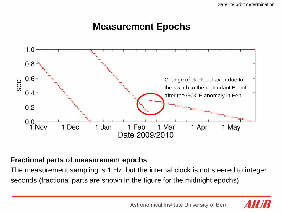
Measurement Epochs
Fractional parts of measurement epochs: The measurement sampling is 1 Hz, but the internal clock is not steered to integer seconds (fractional parts are shown in the figure for the midnight epochs).
Clock jumps of ~ 20 ms are occuring after ~ 27 h
Change of clock behavior due to the switch to the redundant B-unit after the GOCE anomaly in Feb.

Satellite orbit determination
Astronomical Institute University of Bern
Dynamic Orbit Representation (1)
Satellite position (in inertial frame) is given by:
LEO center of mass position
LEO antenna phase center offset
LEO initial osculating orbital elements
LEO dynamical parameters
- One set of initial conditions (orbital elements) is estimated per arc Dynamical parameters of the force model on request
Satellite trajectory
is a particular solution of an equation of motion
Satellite orbit determination
Astronomical Institute University of Bern
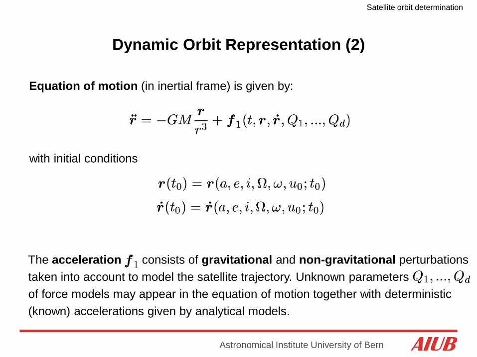
Dynamic Orbit Representation (2)
Equation of motion (in inertial frame) is given by:
with initial conditions
The acceleration
consists of gravitational and non-gravitational perturbations taken into account to model the satellite trajectory. Unknown parameters of force models may appear in the equation of motion together with deterministic (known) accelerations given by analytical models.
Satellite orbit determination
Astronomical Institute University of Bern
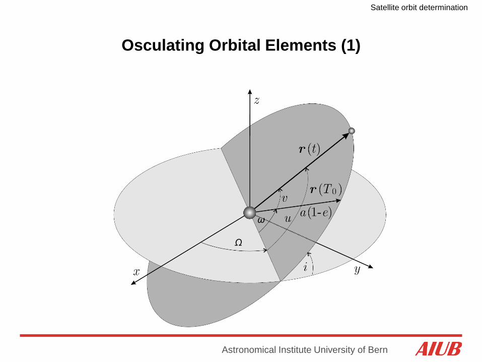
Osculating Orbital Elements (1)
Ω
ω

Satellite orbit determination
Astronomical Institute University of Bern
Osculating Orbital Elements of GOCE (2)
Semi-major axis: Twice-per-revolution variations of about ±10 km around the mean semi-major axis of 6632.9km, which corresponds to the 254.9 km mean altitude used by ESA

Satellite orbit determination
Astronomical Institute University of Bern
Osculating Orbital Elements of GOCE (3)
Numerical eccentricity: Small, short-periodic variations around the mean value of about 0.0025, i.e., the orbit is close to circular
Satellite orbit determination
Astronomical Institute University of Bern
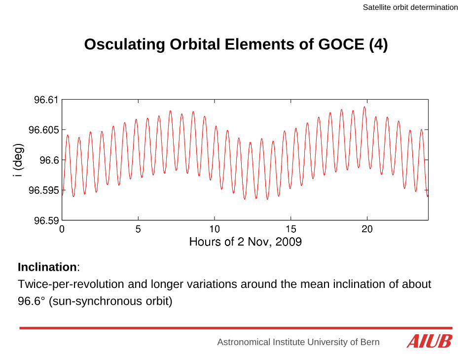
Osculating Orbital Elements of GOCE (4)
Inclination: Twice-per-revolution and longer variations around the mean inclination of about 96.6° (sun-synchronous orbit)
Satellite orbit determination
Astronomical Institute University of Bern
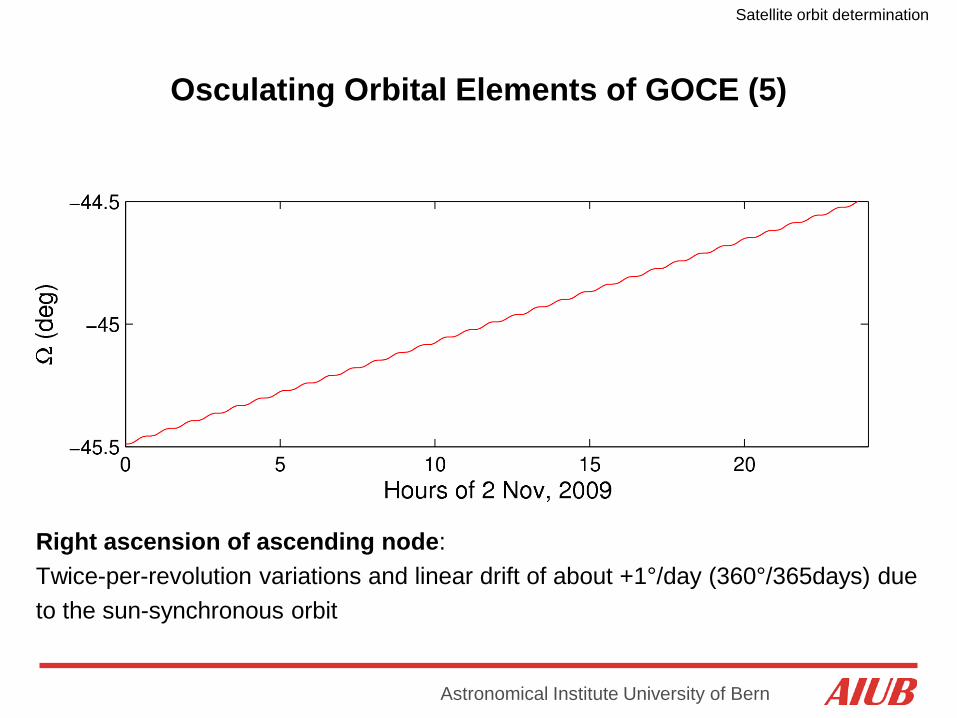
Osculating Orbital Elements of GOCE (5)
Right ascension of ascending node: Twice-per-revolution variations and linear drift of about +1°/day (360°/365days) due to the sun-synchronous orbit
Satellite orbit determination
Astronomical Institute University of Bern
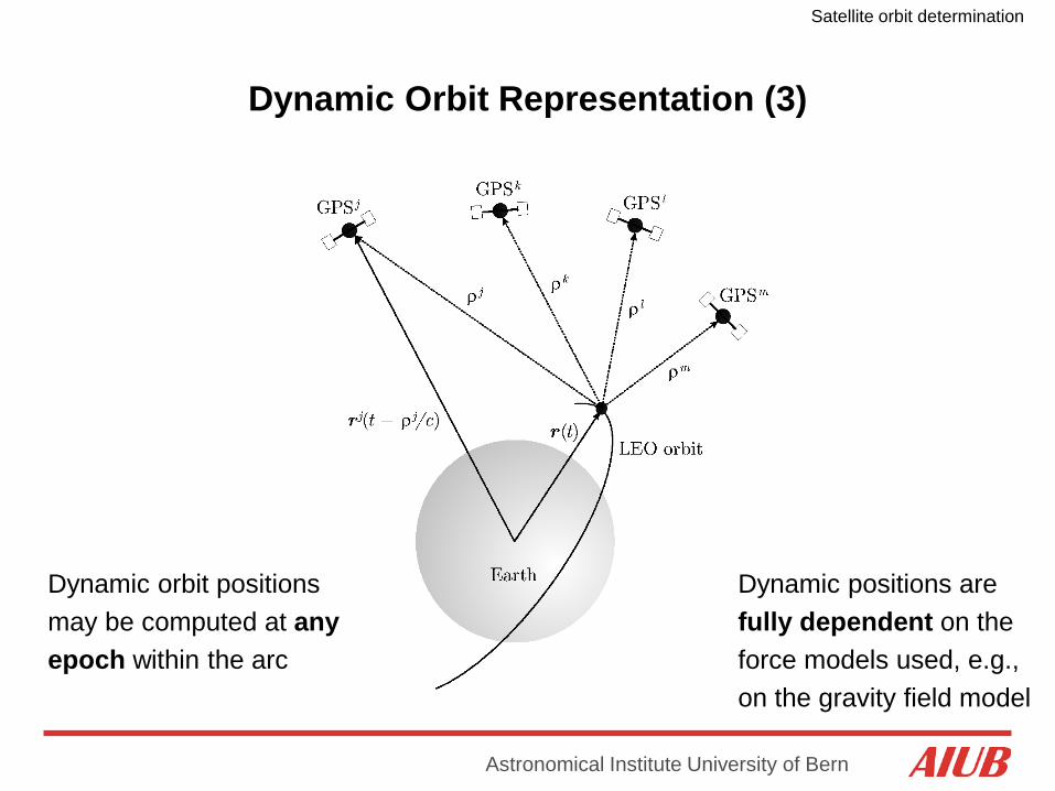
Dynamic Orbit Representation (3)
Dynamic orbit positions may be computed at any epoch within the arc
Dynamic positions are fully dependent on the force models used, e.g., on the gravity field model

Satellite orbit determination
Astronomical Institute University of Bern
Reduced-Dynamic Orbit Representation (1)
Equation of motion (in inertial frame) is given by:
Pseudo-stochastic parameters are:
- additional empirical parameters characterized by a priori known statistical properties, e.g., by expectation values and a priori variances
- useful to compensate for deficiencies in dynamic models, e.g., deficiencies in models describing non-gravitational accelerations
Pseudo-stochastic parameters
- often set up as piecewise constant accelerations to ensure that satellite trajectories are continuous and differentiable at any epoch
Satellite orbit determination
Astronomical Institute University of Bern
Reduced-Dynamic Orbit Representation (2)
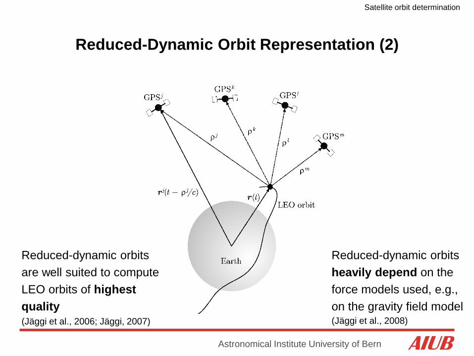
Reduced-dynamic orbits are well suited to compute LEO orbits of highest quality (Jäggi et al., 2006; Jäggi, 2007)
Reduced-dynamic orbits heavily depend on the force models used, e.g., on the gravity field model (Jäggi et al., 2008)
Satellite orbit determination
Astronomical Institute University of Bern
Partial Derivatives
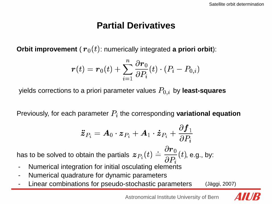
Orbit improvement (
yields corrections to a priori parameter values
Previously, for each parameter the corresponding variational equation
has to be solved to obtain the partials
by least-squares
- Numerical quadrature for dynamic parameters - Linear combinations for pseudo-stochastic parameters
: numerically integrated a priori orbit):
- Numerical integration for initial osculating elements
, e.g., by:
(Jäggi, 2007)
Satellite orbit determination
Astronomical Institute University of Bern
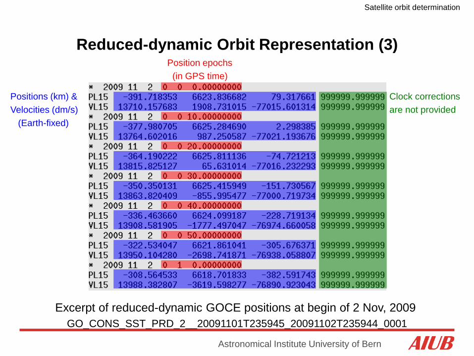
Reduced-dynamic Orbit Representation (3)
Excerpt of reduced-dynamic GOCE positions at begin of 2 Nov, 2009 GO_CONS_SST_PRD_2__20091101T235945_20091102T235944_0001
Clock corrections are not provided
Position epochs (in GPS time)
Positions (km) & Velocities (dm/s) (Earth-fixed)
Satellite orbit determination
Astronomical Institute University of Bern
LEO Sensor Offsets (1)
Phase center offsets :
- are needed in the inertial or Earth-fixed frame and have to be transformed from the satellite frame using attitude data from the star-trackers
- consist of a frequency-independent instrument offset, e.g., defined by the center of the instrument‘s mounting plane (CMP) in the satellite frame
- consist of frequency-dependent phase center offsets (PCOs), e.g., defined wrt the center of the instrument‘s mounting plane in the antenna frame (ARF)
- consist of frequency-dependent phase center variations (PCVs) varying with the direction of the incoming signal, e.g., defined wrt the PCOs in the antenna frame

Satellite orbit determination
Astronomical Institute University of Bern
LEO Sensor Offsets (2)
Offset wrt satellite reference frame (SRF) is constant Offset wrt center of mass (CoM) is slowly varying ~ Nadir pointing
~ Flight direction

Satellite orbit determination
Astronomical Institute University of Bern
GOCE Sensor Offsets
Table 1: CoM coordinates in SRF system
CoM XSRF[m] YSRF[m] ZSRF[m]
Begin of Life (BoL) 2.4990 0.0036 0.0011
End of Life (EoL) 2.5290 0.0038 0.0012
Table 2: SSTI antenna CMP coordinates in SRF system
CMP coordinates XSRF [m] YSRF[m] ZSRF[m]
Main 3.1930 0.0000 -1.0922
Redundant 1.3450 0.0000 -1.0903
Table 3: SSTI antenna CMP coordinates wrt to CoM (BoL)
CMP coordinates XCoM [m] YCoM[m] ZCoM[m]
Main 0.6940 -0.0036 -1.0933
Redundant -1.1540 -0.0036 -1.0914
Derived from Bigazzi and Frommknecht (2010)
Table 4: SSTI antenna phase center offsets in ARF system
Phase center offsets XARF[mm] YARF[mm] ZARF[mm]
Main: L1 -0.18 3.51 -81.11
Main: L2 -1.22 -1.00 -84.18
Redundant: L1 -0.96 3.14 -81.33
Redundant: L2 -1.48 -1.20 -84.18
Satellite orbit determination
Astronomical Institute University of Bern
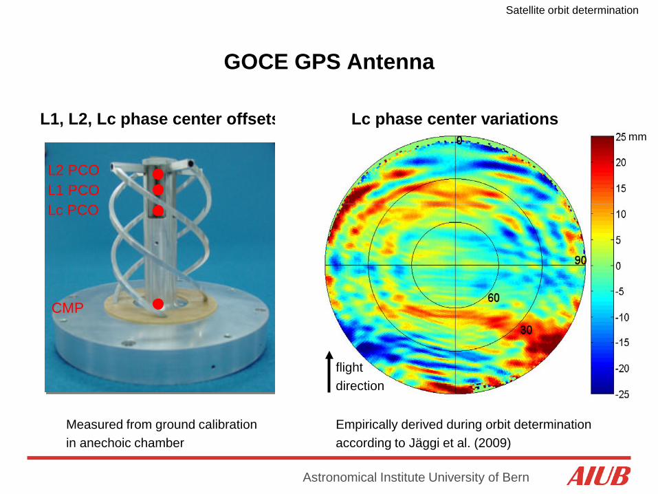
GOCE GPS Antenna
CMP
L1 PCO L2 PCO
L1, L2, Lc phase center offsets
Measured from ground calibration in anechoic chamber
Lc PCO
mm Lc phase center variations
flight direction
Empirically derived during orbit determination according to Jäggi et al. (2009)
Satellite orbit determination
Astronomical Institute University of Bern
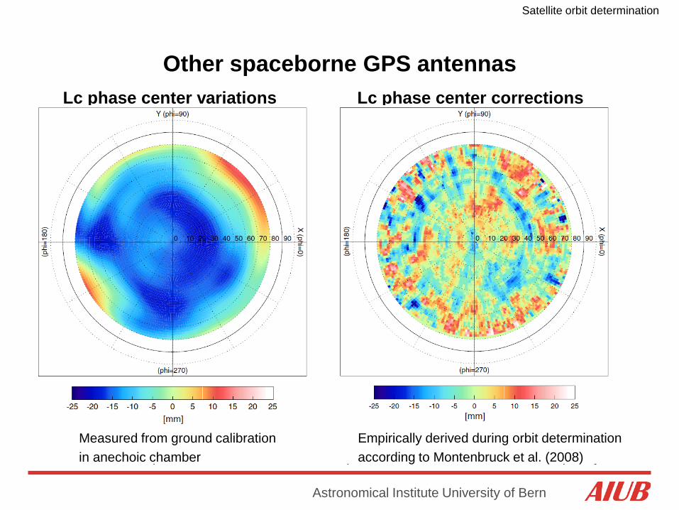
Other spaceborne GPS antennas
GPS zenith looking antenna (GZA) onboard MetOp-A
GZA is made up of two independent annular patch elements for the L1 and L2 frequency
Lc phase center variations
Measured from ground calibration in anechoic chamber
Lc phase center corrections
Empirically derived during orbit determination according to Montenbruck et al. (2008)

Satellite orbit determination
Astronomical Institute University of Bern
GOCE High-level Processing Facility: Orbit Groups
Responsibilities: DEOS => RSO (Rapid Science Orbit) AIUB => PSO (Precise Science Orbit) IAPG => Validation

Satellite orbit determination
Astronomical Institute University of Bern
GOCE High-level Processing Facility: Orbit Products
Orbit solution Software GPS
Observ. GPS
products Sampling Data batches Latency
RSO
reduced-dynamic GEODYN triple-diff IGS
rapid 10 sec 30 h 1 day
kinematic GHOST zero-diff CODE rapid 1 sec 24 h 1 day
PSO
reduced-dynamic BERNESE zero-diff CODE
final 10 sec 30 h 7-10 days
kinematic BERNESE zero-diff CODE final 1 sec 30 h 7-10
days
(Visser et al., 2009)
Accuracy requirement: 50 cm
(Bock et al., 2011)
Accuracy requirement: 2 cm
Satellite orbit determination
Astronomical Institute University of Bern
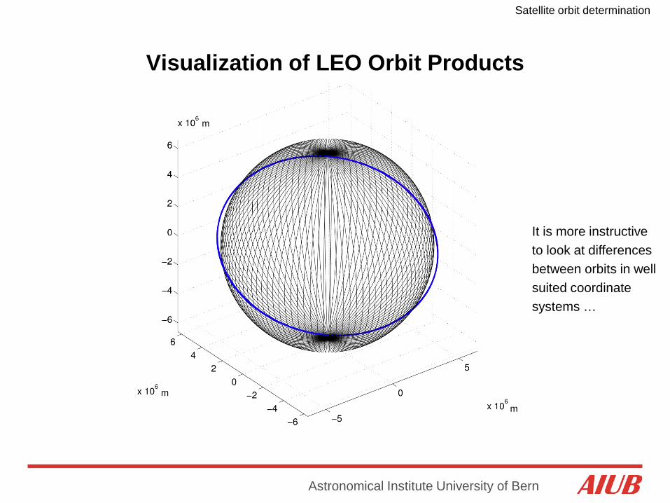
Visualization of LEO Orbit Products
It is more instructive to look at differences between orbits in well suited coordinate systems …
m
m
m

Satellite orbit determination
Astronomical Institute University of Bern
Co-Rotating Orbital Frames
R, S, C unit vectors are pointing:
- into the radial direction
- normal to R in the orbital plane - normal to the orbital plane (cross-track)
T, N, C unit vectors are pointing:
- into the tangential (along-track) direction
- normal to T in the orbital plane - normal to the orbital plane (cross-track)
Small eccentricities: S~T (velocity direction)

Satellite orbit determination
Astronomical Institute University of Bern
GOCE Orbit Differences KIN-RD
Differences at epochs of kin. positions
Satellite orbit determination
Astronomical Institute University of Bern
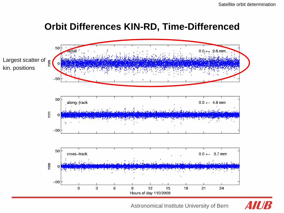
Orbit Differences KIN-RD, Time-Differenced
Largest scatter of kin. positions

Satellite orbit determination
Astronomical Institute University of Bern
GOCE Pseudo-Stochastic Accelerations
Largest signal due to air-drag First drag-free flight on 7 May

Satellite orbit determination
Astronomical Institute University of Bern
GOCE Orbital Altitude at Mission Begin
7 May: First drag-free flight
13/14 September: Arrival at final orbital altitude of 259.6 km (254.9 km), start of drag-free flight for first Measurement and Operational Phase (MOP-1)
GOCE „History“: 17 March: Launch into a sun-synchronous (i ~ 97°), dusk-dawn orbit at an altitude of 287.9 km
26 May: Second drag-free flight with various activities on gradiometer calibration
Satellite orbit determination
Astronomical Institute University of Bern
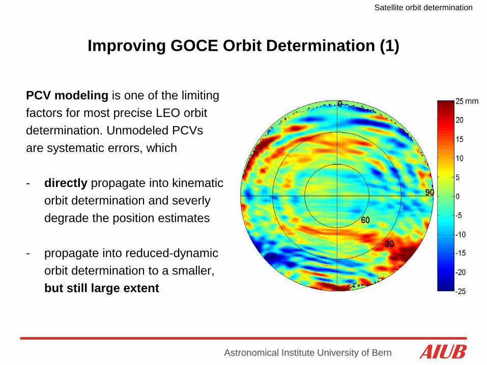
Improving GOCE Orbit Determination (1)
mm PCV modeling is one of the limiting factors for most precise LEO orbit determination. Unmodeled PCVs are systematic errors, which - directly propagate into kinematic orbit determination and severly degrade the position estimates - propagate into reduced-dynamic orbit determination to a smaller, but still large extent
Satellite orbit determination
Astronomical Institute University of Bern
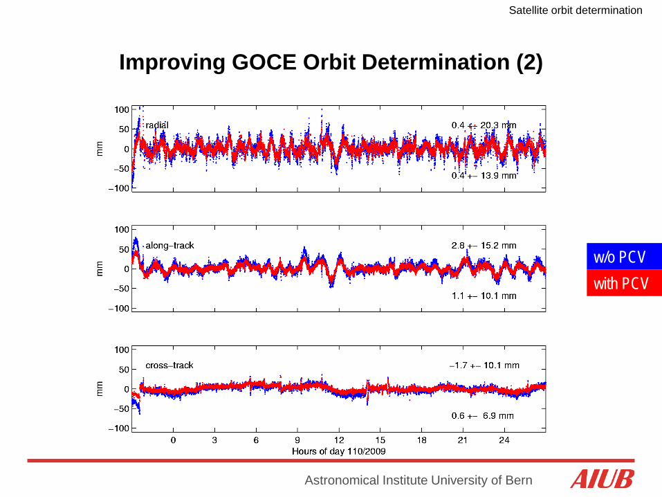
Improving GOCE Orbit Determination (2)
w/o PCV with PCV

Satellite orbit determination
Astronomical Institute University of Bern
GRACE-B antenna
GRACE-A antenna
mm mm
cross-talk of active occultation antenna
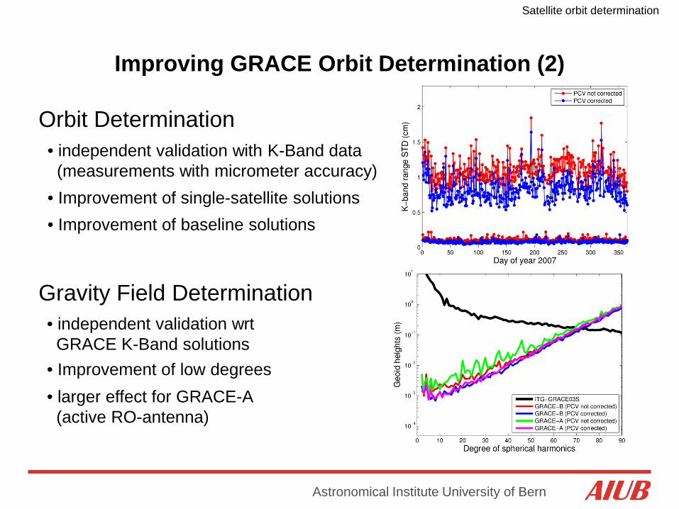
Improving GRACE Orbit Determination (1)
Satellite orbit determination
Astronomical Institute University of Bern
• Improvement of low degrees
Orbit Determination • independent validation with K-Band data (measurements with micrometer accuracy)
Gravity Field Determination • independent validation wrt GRACE K-Band solutions
• Improvement of single-satellite solutions
• larger effect for GRACE-A (active RO-antenna)
• Improvement of baseline solutions
Improving GRACE Orbit Determination (2)

Satellite orbit determination
Astronomical Institute University of Bern
Single-Frequency Orbit Determination
Reduced-Dynamic Orbit Determination
Kinematic Orbit Determination
The so-called GRAPHIC (GRoup And PHase Ionospheric Correction) linear combination 0.5.(L1 + C1) was formed to compute solution B
(Bock et al., 2009b)
Satellite orbit determination
Astronomical Institute University of Bern
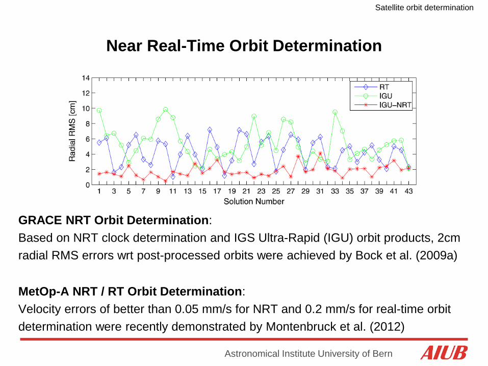
Near Real-Time Orbit Determination
GRACE NRT Orbit Determination: Based on NRT clock determination and IGS Ultra-Rapid (IGU) orbit products, 2cm radial RMS errors wrt post-processed orbits were achieved by Bock et al. (2009a)
MetOp-A NRT / RT Orbit Determination: Velocity errors of better than 0.05 mm/s for NRT and 0.2 mm/s for real-time orbit determination were recently demonstrated by Montenbruck et al. (2012)

Satellite orbit determination
Astronomical Institute University of Bern
Orbit Validation by Satellite Laser Ranging (SLR)
GFZ SLR station in Potsdam, Germany AIUB SLR station in Zimmerwald, Switzerland
Satellite orbit determination
Astronomical Institute University of Bern
GOCE Orbit Accuracy from SLR Residuals (1)
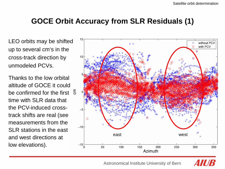
LEO orbits may be shifted up to several cm‘s in the cross-track direction by unmodeled PCVs.
Thanks to the low orbital altitude of GOCE it could be confirmed for the first time with SLR data that the PCV-induced cross- track shifts are real (see measurements from the SLR stations in the east and west directions at low elevations).
west east

Satellite orbit determination
Astronomical Institute University of Bern
w/o PCVs with PCVs
flight direction
nadir angle
mm
The PCV-induced cross-track shifts are best visualized when plotting the SLR residuals in a satellite-fixed coordinate system. This illustrates that SLR is not only able to detect radial biases.
GOCE Orbit Accuracy from SLR Residuals (2)
Satellite orbit determination
Astronomical Institute University of Bern
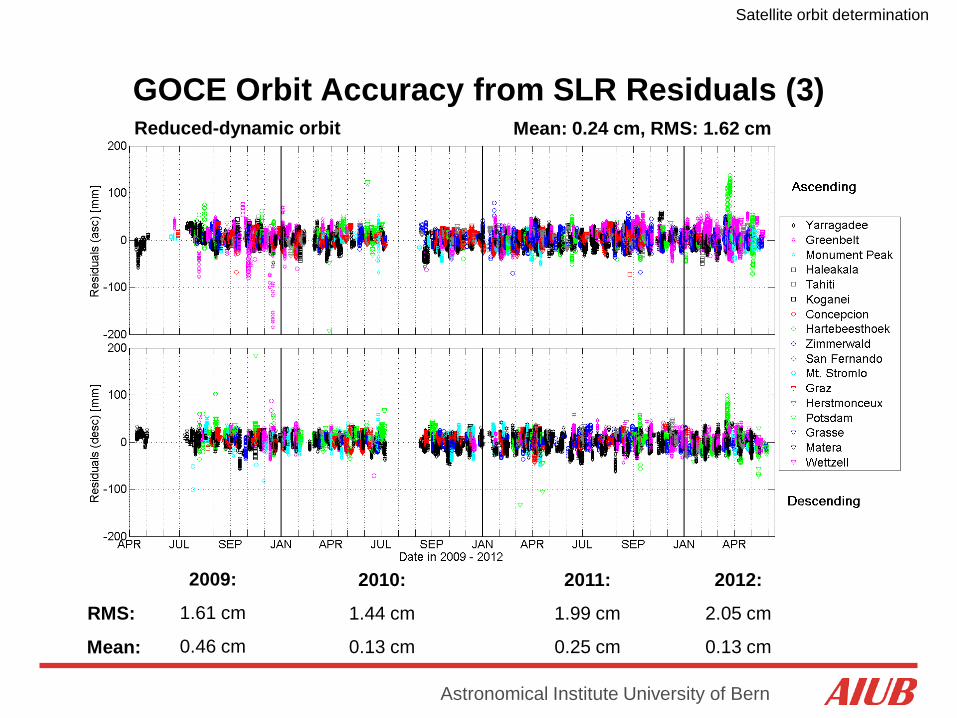
Reduced-dynamic orbit Mean: 0.24 cm, RMS: 1.62 cm
2009:
1.61 cm
0.46 cm
2010:
1.44 cm
0.13 cm
2011:
1.99 cm
0.25 cm
2012:
2.05 cm
0.13 cm
RMS:
Mean:
GOCE Orbit Accuracy from SLR Residuals (3)
Satellite orbit determination
Astronomical Institute University of Bern
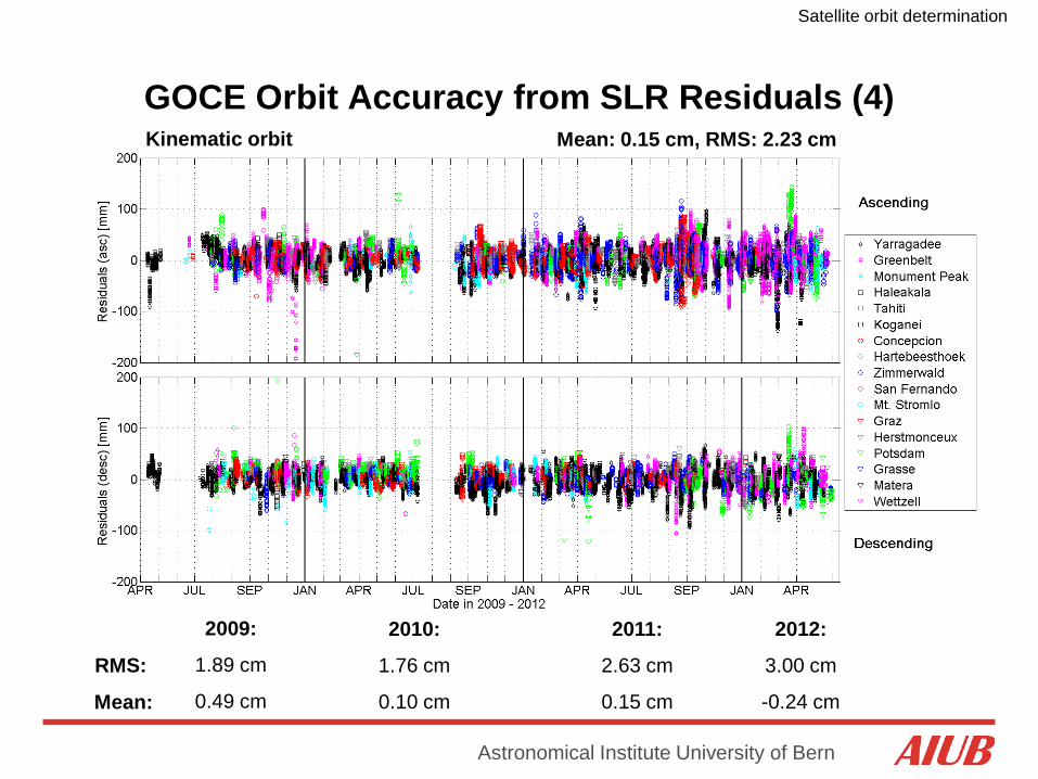
Kinematic orbit Mean: 0.15 cm, RMS: 2.23 cm
2009:
1.89 cm
0.49 cm
2010:
1.76 cm
0.10 cm
2011:
2.63 cm
0.15 cm
2012:
3.00 cm
-0.24 cm
RMS:
Mean:
GOCE Orbit Accuracy from SLR Residuals (4)
Satellite orbit determination
Astronomical Institute University of Bern
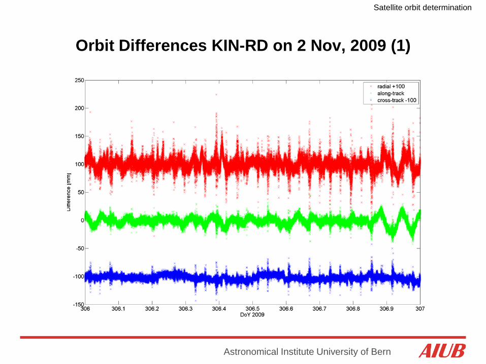
Orbit Differences KIN-RD on 2 Nov, 2009 (1)

Satellite orbit determination
Astronomical Institute University of Bern
Orbit Differences KIN-RD on 2 Nov, 2009 (2)
Larger differences twice-per-revolution

Satellite orbit determination
Astronomical Institute University of Bern
Orbit Differences KIN-RD on 2 Nov, 2009 (3)
Larger differences over polar regions
Satellite orbit determination
Astronomical Institute University of Bern
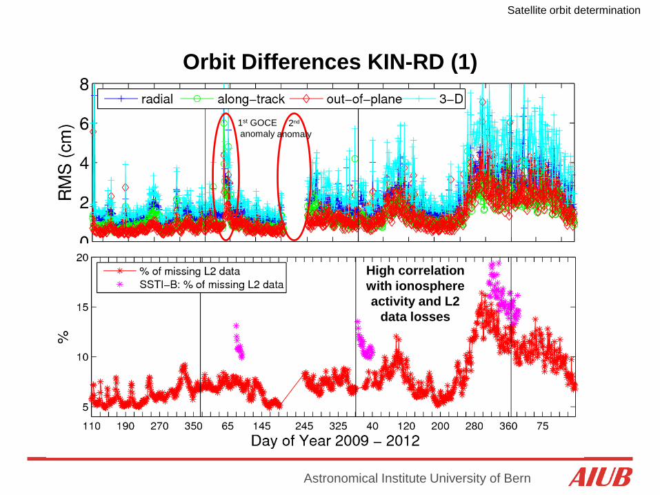
The results show the consistency between both orbit-types and mainly reflect the quality of the kinematic orbits. It is, however, not a direct measure of orbit quality.
2009:
1.7 cm
2010:
2.2 cm
2011:
3.4 cm
2012:
4.3 cm
RMS:
High correlation with ionosphere activity and L2
data losses
1st GOCE anomaly
2nd anomaly
High correlation with ionosphere activity and L2
data losses
Orbit Differences KIN-RD (1)
Satellite orbit determination
Astronomical Institute University of Bern
2009
2010
2011 2012
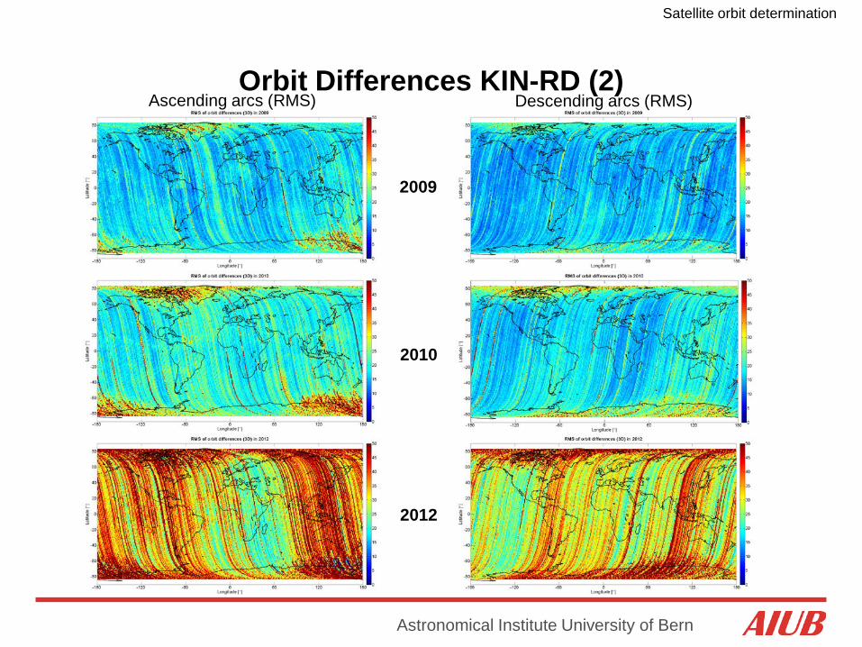
Ascending arcs (RMS) Descending arcs (RMS) Orbit Differences KIN-RD (2)
Satellite orbit determination
Astronomical Institute University of Bern
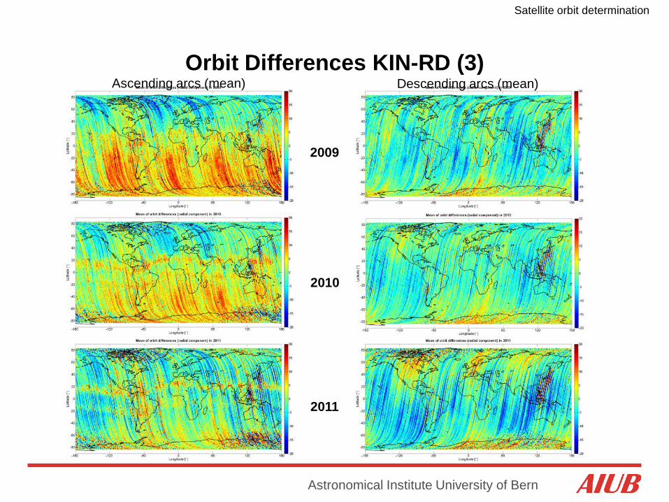
2009
2010
2011
Ascending arcs (mean) Descending arcs (mean) Orbit Differences KIN-RD (3)

Satellite orbit determination
Astronomical Institute University of Bern
Phase observation residuals mapped to the crossing of the ionosphere layer
Phase Residuals
Satellite orbit determination
Astronomical Institute University of Bern
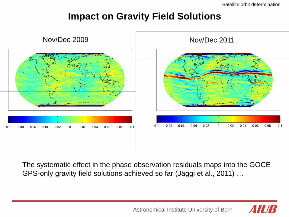
The systematic effect in the phase observation residuals maps into the GOCE GPS-only gravity field solutions achieved so far (Jäggi et al., 2011) …
Nov/Dec 2009 Nov/Dec 2011
Impact on Gravity Field Solutions
Satellite orbit determination
Astronomical Institute University of Bern
Literature (1) Blewitt, G. (1997): Basics of the GPS Technique: Observation Equations, in
Geodetic Applications of GPS, Swedish Land Survey, pp. 10-54, available at http://www.nbmg.unr.edu/staff/pdfs/Blewitt Basics of gps.pdf
Bigazzi, A., B. Frommknecht (2010): Note on GOCE instruments positioning, XGCE-GSEG-EOPG-TN-09-0007, Issue 3.1, European Space Agency, available at http://earth.esa.int/download/goce/GOCE-LRR-GPS-positioning-Memo_3.1_[XGCE-GSEG-EOPG-TN-09-0007 20v3.1].pdf
Bock, H., R. Dach, Y. Yoon, O. Montenbruck (2009a): GPS Clock Correction Estimation for Near Real-time Orbit Determination Applications. Aerospace Science and Technology, 13(7), 415-422, doi: 10.1016/j.ast.2009.08.003
Bock, H., A. Jäggi, R. Dach, G. Beutler, S. Schaer (2009b): GPS single-frequency orbit determination for Low Earth Orbiting satellites. Advances in Space Research, 43(5), 783-791, doi: 10.1016/j.asr.2008.12.003
Bock, H., R. Dach, A. Jäggi, G. Beutler (2009c): High-rate GPS clock corrections from CODE: Support of 1 Hz applications. Journal of Geodesy, 83(11), 1083-1094, doi: 10.1007/s00190-009-0326-1

Satellite orbit determination
Astronomical Institute University of Bern
Literature (2) Bock, H., A. Jäggi, U. Meyer, P. Visser, J. van den IJssel, T. van Helleputte, M.
Heinze, U. Hugentobler (2011): GPS-derived orbits for the GOCE satellite. Journal of Geodesy, 85(11), 807-818, doi: 10.1007/s00190-011-0484-9
Dach, R., E. Brockmann, S. Schaer, G. Beutler, M. Meindl, L. Prange, H. Bock, A. Jäggi, L. Ostini (2009): GNSS processing at CODE: status report, Journal of Geodesy, 83(3-4), 353-366, doi: 10.1007/s00190-008-0281-2
Hauschild, A., O. Montenbruck (2008): Real-time clock estimation for precise orbit determination of LEO-satellites, ION-GNSS-2008, Savannah
Jäggi, A., U. Hugentobler, G. Beutler (2006): Pseudo-stochastic orbit modeling techniques for low-Earth satellites. Journal of Geodesy, 80(1), 47-60, doi: 10.1007/s00190-006-0029-9
Jäggi, A. (2007): Pseudo-Stochastic Orbit Modeling of Low Earth Satellites Using the Global Positioning System. Geodätisch-geophysikalische Arbeiten in der Schweiz, 73, Schweizerische Geodätische Kommission, available at http://www.sgc.ethz.ch/sgc-volumes/sgk-73.pdf
Satellite orbit determination
Astronomical Institute University of Bern
Literature (3) Jäggi, A., H. Bock, R. Pail, H. Goiginger (2008): Highly Reduced-Dynamic
Orbits and their Use for Global Gravity Field Recovery: A Simulation Study for GOCE, Studia Geophysica et Geodaetica, 52(3), 341-359, doi: 10.1007/s11200-008-0025-z
Jäggi, A., R. Dach, O. Montenbruck, U. Hugentobler, H. Bock, G. Beutler (2009): Phase center modeling for LEO GPS receiver antennas and its impact on precise orbit determination. Journal of Geodesy, 83(12), 1145-1162, doi: 10.1007/s00190-009-0333-2
Jäggi, A., H. Bock, L. Prange, U. Meyer, G. Beutler (2011): GPS-only gravity field recovery with GOCE, CHAMP, and GRACE. Advances in Space Research, 47(6), 1020-1028, doi: 10.1016/j.asr.2010.11.008.
Montenbruck, O., Y. Andres, H. Bock, T. van Helleputte, J. van den IJssel, M. Loiselet, C. Marquardt, P. Silvestrin, P. Visser, Y. Yoon (2008): Tracking and orbit determination performance of the GRAS instrument on MetOp-A. GPS Solutions, 12(4), 289-299, doi: 10.1007/s10291-008-0091-2
Satellite orbit determination
Astronomical Institute University of Bern
Literature (4) Montenbruck O., A. Hauschild, Y. Andres, A. von Engeln, Ch. Marquardt
(2012): (Near-)Real-Time Orbit Determination for GNSS Radio Occultation Processing. GPS Solutions, 17(2), 199-209, doi: 10.1007/s10291-012-0271-y
Švehla, D., M. Rothacher (2004): Kinematic Precise Orbit Determination for Gravity Field Determination, in A Window on the Future of Geodesy, edited by F. Sanso, pp. 181-188, Springer, doi: 10.1007/b139065
Visser, P., J. van den IJssel, T. van Helleputte, H. Bock, A. Jäggi, G. Beutler, D. Švehla, U. Hugentobler, M. Heinze (2009): Orbit determination for the GOCE satellite, Advances in Space Research, 43(5), 760-768, doi: 10.1016/j.asr.2008.09.016.