Embed Size (px)
Citation preview

HAL Id: hal-02433417https://hal-normandie-univ.archives-ouvertes.fr/hal-02433417
Submitted on 9 Jan 2020
HAL is a multi-disciplinary open accessarchive for the deposit and dissemination of sci-entific research documents, whether they are pub-lished or not. The documents may come fromteaching and research institutions in France orabroad, or from public or private research centers.
L’archive ouverte pluridisciplinaire HAL, estdestinée au dépôt et à la diffusion de documentsscientifiques de niveau recherche, publiés ou non,émanant des établissements d’enseignement et derecherche français ou étrangers, des laboratoirespublics ou privés.
Distributed under a Creative Commons Attribution| 4.0 International License
High-resolution bathymetry of the Alderney Race andits geological and sedimentological description (Raz
Blanchard, northwest France)Lucille Furgerot, Yohann Poprawski, Marc Violet, Emmanuel Poizot, Pascal
Bailly Du Bois, Mehdi Morillon, Yann Méar
To cite this version:Lucille Furgerot, Yohann Poprawski, Marc Violet, Emmanuel Poizot, Pascal Bailly Du Bois, et al..High-resolution bathymetry of the Alderney Race and its geological and sedimentological description(Raz Blanchard, northwest France). Journal of Maps, Taylor & Francis, 2019, 15 (2), pp.708-718.�10.1080/17445647.2019.1657510�. �hal-02433417�

Full Terms & Conditions of access and use can be found athttps://www.tandfonline.com/action/journalInformation?journalCode=tjom20
Journal of Maps
ISSN: (Print) 1744-5647 (Online) Journal homepage: https://www.tandfonline.com/loi/tjom20
High-resolution bathymetry of the AlderneyRace and its geological and sedimentologicaldescription (Raz Blanchard, northwest France)
Lucille Furgerot, Yohann Poprawski, Marc Violet, Emmanuel Poizot, PascalBailly du Bois, Mehdi Morillon & Yann Mear
To cite this article: Lucille Furgerot, Yohann Poprawski, Marc Violet, Emmanuel Poizot, PascalBailly du Bois, Mehdi Morillon & Yann Mear (2019) High-resolution bathymetry of the AlderneyRace and its geological and sedimentological description (Raz Blanchard, northwest France),Journal of Maps, 15:2, 708-718, DOI: 10.1080/17445647.2019.1657510
To link to this article: https://doi.org/10.1080/17445647.2019.1657510
© 2019 The Author(s). Published by InformaUK Limited, trading as Taylor & FrancisGroup on behalf of Journal of Maps
View supplementary material
Published online: 10 Sep 2019.
Submit your article to this journal
View related articles
View Crossmark data

Science
High-resolution bathymetry of the Alderney Race and its geological andsedimentological description (Raz Blanchard, northwest France)Lucille Furgerota, Yohann Poprawskib, Marc Violetc, Emmanuel Poizota,d, Pascal Bailly du Boise,Mehdi Morillone and Yann Meara,d
aLUSAC, Laboratoire Universitaire des Sciences Appliquées de Cherbourg, University of Normandie, Cherbourg-Octeville, France; bGeologicDiffusion, Bordeaux, France; cPositioning, Hydrographic and Geophysic Services, Montfarville, France; dConservatoire National des Arts etMétiers, Intechmer, Cherbourg-en-Cotentin, France; eIRSN/DEI/SECRE/LRC, Institut de Radioprotection et de Sûreté Nucléaire, Direction del’Environnement et de l’Intervention, Laboratoire de Radioécologie de Cherbourg-Octeville, France
ABSTRACTWe present a high-resolution 1:15,000 bathymetric map (Main map) of Alderney Race locatedoffshore of northwestern France, with the strongest currents in Europe. We use this map,underwater video transects and Shipek grabs to improve geological maps previouslypublished. We distinguished Proterozoic crystalline rocks, Paleozoic and Cretaceoussedimentary rocks on the present-day sea floor. Some structures as faults and folds are alsomapped. We identified a Quaternary cover made of pebbles, boulders and blocks interpretedas corestones resulting in differential erosion and alteration of the substratum. This cover iscommonly encrusted by fixed fauna, such as bryozoans and barnacles. Finally, we describethe present-day mobile sediment cover characterized by sand patches and pebble dunefields (up to 10 m in height). Our videos show the presence of mobile fine-grained sedimentpatches under the resolution of our map lying between the cobble and pebble cover. Wesummarize our interpretations on a non-exhaustive geological-sedimentary map.
ARTICLE HISTORYReceived 28 February 2019Revised 2 August 2019Accepted 6 August 2019
KEYWORDSHigh-resolution bathymetry;Morpho-sedimentologicalcartography; Alderney Race;Shipek grab; submarinecamera
1. Introduction
The English Channel is characterized by strong tidalcurrents, reaching up to 5 m.s−1 in the Alderney Raceand thus is a suitable area for tidal turbines installationfor Marine Renewable Energy creation. Several studieson tidal stream resource estimation and turbine impacton the flow have been carried out in the Alderney Race(Bailly du Bois, Dumas, Solier, & Voiseux, 2012; Coles,Blunden, & Bahaj, 2017; Thiébot, Bailly du Bois, &Guillou, 2015), however only a few studies about sedi-ment transport (Thiébot et al., 2015) and bathymetryhave been done. Although deposition of fine particlesis expected to be difficult with strong currents, Foveauand Dauvin (2017) described mobile sediment patches,mainly composed of sand and pebbles. Coarser sedi-ments dominated by pebbles and cobbles have beendescribed by Larsonneur, Bouysse, and Auffret (1982)around the exposed bedrock. Foveau and Dauvin(2017) also described poorly sorted and rounded coarsesediments lacking of fixed fauna, reflecting theimportant bedload transport in these high-energyenvironments.
In the Alderney Race, the morphology of the bed-rock and the presence of sediments available for trans-port are poorly constrained. However, this knowledgeessential for tidal turbine installation: (i) for
improvement of tidal stream resource estimation withnumerical modeling considering the turbulence gener-ated by bed roughness and depth variations, (ii) for theimpact of the turbines on sediment, and conversely (iii)for possible sediment abrasive impact on the turbines.
This paper aims to (1) describe and identify differentmorphologies from the bathymetric map (Main map)in the Alderney Race area, (2) provide an interpretationfor these different bathymetric morphologies usingpreviously published geological and sedimentologicalinformation, new underwater video observations andsediment samples, and (3) show the presence of finesediments potentially mobile with the strong currentof the study area.
2. Regional setting
The study area displays Paleo and Neoproterozoic crys-talline rocks and Paleozoic and Cretaceous sedimen-tary rocks (Figure 1(B)). It includes the Icartiangneiss (Paleoproterozoic Pentevrian basement,2.1 Ga) exposed in the Anse du Culeron (located onFigure 2). The Neoproterozoic crystalline rocks consistof two generations of quartz diorite plutons, emplacedfrom 620 to 608 Ma in a back-arc setting and from 570to 540 Ma during the Cadomian orogeny (e.g.
© 2019 The Author(s). Published by Informa UK Limited, trading as Taylor & Francis Group on behalf of Journal of MapsThis is an Open Access article distributed under the terms of the Creative Commons Attribution License (http://creativecommons.org/licenses/by/4.0/), which permits unrestricteduse, distribution, and reproduction in any medium, provided the original work is properly cited.
CONTACT Lucille Furgerot [email protected] LUSAC, Laboratoire Universitaire des Sciences Appliquées de Cherbourg, University ofNormandie, 145 Chemin de la Crespinière, 50130 Cherbourg-Octeville, France
JOURNAL OF MAPS2019, VOL. 15, NO. 2, 708–718https://doi.org/10.1080/17445647.2019.1657510

Dallmeyer, D’Lemos, Strachan, &Mueller, 1991; Inglis,Samson, D’Lemos, & Miller, 2005). Cadomian struc-tures in the area consist of SE-directed thrusts strikingN45, with a left-lateral component (e.g. Ballèvre, LeGoff, & Hébert, 2001; Chantraine et al., 2001).
The Paleozoic succession consists of Cambrian toDevonian sedimentary rocks, exposed in the Siouvilleand Jobourg Synclines (Figure 1(B)), striking N110.These synclines are a result of the Variscan Orogeny(Dissler & Gresselin, 1988), that occurred around320 Ma in the area (Ballèvre, Bosse, Ducassou, &Pitra, 2009).
The Mesozoic succession is composed of Triassicconglomerates, exposed near the La Pernelle Plateauand Upper Cretaceous flint-bearing chalk mapped inthe offshore in the northwest part of our study area(Larsonneur & Walker, 1982). During the Mesozoic,several regression and transgression cycles occurredabove the Variscan basement. Early to Middle Jurassicsedimentary rocks deposited and have been sub-sequently eroded in the Cotentin Peninsula (e.g.Dugué, 2007). During the Early Cretaceous a major
regressive event occurred, evidenced by a weatheringand peneplation surface found in Brittany and Nor-mandy (Bessin, Guillocheau, Robin, Schroëtter, &Bauer, 2015). During the Late Cretaceous, previouslyemerged surfaces were drowned by transgression, asBRGM maps (Bureau des Ressources Géologiques etMinières) show remnants of Upper Cretaceous flint-bearing chalk above Proterozoic and Paleozoic rockin Brittany (e.g. Doré, Dupret, Le Gall, & Chalot-Prat, 1977; see Bessin et al., 2015 for more details).
During Cenozoic, the Cotentin Peninsula under-went uplift, as shown by four marine terraces andfour Rasas (Pedoja et al., 2018). This regional uplift isrelated to the far-field effects of the Alpine orogenythat induced the reactivation of some faults, such asthe La Hague fault (e.g. Lagarde et al., 2000, 2003).Quaternary eustatic sea level falls (up to −110 mbelow present-day sea level) linked with major climaticchanges induced strong incision, as the Cotentin andthe La Hague deeps (up to 90 m bsl) are interpretedas a fluvial paleo-drainage related to tributary riversof the Seine (Antoine et al., 2003) (Figure 1(A)).
Figure 1. (A). Map of the English Channel showing the deeps that coincide with the paleo-Seine and its tributaries (Antoine et al.,2003) and the location of our study area (red rectangle); (B). Geological map (modified from geological map of France 1/50 000); (C).Sedimentary map (modified from data.shom); (D). Simplified bathymetric map showing the maximal tidal current intensities at highand low tides from numerical model MARS2D, resolution of 100 m (method from Bailly du Bois et al., 2012).
JOURNAL OF MAPS 709

At present, strong tidal currents prevent significantdeposition in the deeps, preserving the Quaternaryfluvial paleo-drainage (Lericolais, 1997). The regionaltwo-dimensional currents model (MARS2D) of Baillydu Bois et al. (2012) shows high northward/southwardtidal currents west of La Hague Cape (red arrows inFigure 1(D)). North of the Peninsula, the eastward/westward currents align with the La Hague deep.This model has been validated by numerous physicaloceanographic data acquired with conventional tech-niques: bathymetric survey, measurement of variationsin water levels, current measurements, tracking of drif-ters and dispersion of soluble tracers (details in Baillydu Bois et al., 2012). Since, other models and newfield campaigns have been used to improve knowledgeof the hydrodynamics (Thiébot et al., 2015). Currentsgenerally exceed 2 m s−1 and reach up to 5 m s−1
during the peak of spring tide and thus are able tomove particles of several cm in diameter according toHjulström (1935). The sedimentary map from theShom (Service Hydrographique et Océanographique
de la Marine) database (Figure 1(C)) shows diversetypes of sediments ranging from sand in the bays tocobbles near the exposed bedrock. Despite the strongcurrents in this area, patches of mixed sand and peb-bles are described in the Alderney Race area on thismap and in Foveau and Dauvin (2017) (Figure 1(C)).
3. Methods
3.1. Bathymetry
Various bathymetric sources were data used to buildthe bathymetric map come from:
(1) the HOMONIM project for the main dataset,acquired using multibeam echosounders (resol-ution up to 1 m) or with a single beam sounder(resolution up to 100 m) (Shom, 2015);
(2) the NHDF (Normandie Hauts de France) lidarproject 2016–2017 focused on the coastal fringewith a horizontal resolution of 1 m (Shom-
Figure 2. Bathymetric map of the Alderney Race with the location of video transects (red stars, named Tn or Vn with indicating theend of transect). Specific bathymetric morphologies (blue rectangles) are described in detail on the next figures. The yellow trans-ects indicate the bathymetric sections. The dashed brown rectangle represents the high bathymetric map extent.
710 L. FURGEROT ET AL.

ROLNP, 2018) up to 10 m of depth (at least) andsometimes 20 m (depends on the transparency ofthe water);
(3) and the BATHAGUE project 2008–2010, for theshallow depths (from 2 or 3 m up to 60 m) andacquired by IRSN (Institut de Radioprotection etde Sûreté Nucléaire) using an interferometricsonar (resolution up to 1 m) (Bailly du Bois, 2008).
The final bathymetric map was created using Uni-versal Transverse Mercator (UTM 30N) conformalprojection and WGS84 reference ellipsoid. The heightreference (0 m elevation) was fixed on the low springtide mean level in Goury (located on bathymetricmap). The difference between the local Hydrographiczero and the terrestrial zero (IGN69) is 4.827 m (refer-ence: Référénce Altimétriques Maritimes du Shom).
This map identified by a brown rectangle in Figure 2covers the NW of Cotentin Peninsula. However, ourstudy area extends southward, as the southern areasare essential to connect the onshore geology withoffshore areas (Figure 1(B)). This southern area is notintegrated into the bathymetric map because of thelack of high-resolution bathymetric data (blanks inFigure 2 and bathymetric map).
We used the high-resolution bathymetric map toidentify different morphologies, such as tilted Paleozoicbeds, Paleozoic and Proterozoic crystalline rocks, Cre-taceous flatbed surfaces and present-day subaqueousdunes. The interpretation of these substrate typesconfirmed using onshore-offshore correlations fromthe available geological maps and compared with aerialphotographs of the emerged rocky platform. We alsoused the bathymetric map to build bathymetric sec-tions allowing the observation of large structures,such as dunes and the measurement of bedding dips,only for the low-dipping Cretaceous strata.
3.2. Nature of the seabed
We used an underwater camera and a Shipek grab toconfirm our interpretations of the described mor-phologies from bathymetric map and provide additionaland more accurate information on sedimentary cover(location of points in Figure 2).
The underwater video allows the characterization ofthe sediment cover at the scale of several square meters.However, the camera can only be deployed for 15 minwhen currents decrease during the short slack currentwater and only in good weather conditions. Thedeployment depth is limited by cable length for thehigh definition transmission to the boat (70 m). Ascale of 10 cm fixed between the three weighted feetof the camera allows the estimation of the size of sedi-ments when it reaches the bottom. Therefore, thevideos provide information about the size of sedimenton the bottom and their location for the lowest current
velocity stage. Twenty-three video (covering in totalabout 3 km²) transects were conducted for a qualitativedescription of the sedimentary cover.
As the Shipek grab is working only for pebbles orfiner sediments that relatively rare in the area, only 8samples among the 12 collected yielded a sufficientvolume of sediment for analyses. These samples pro-vide direct information on seabed composition.
4. Results and discussion
4.1. Geology of the deep domain
The La Hague deep consists of a deep submarinetrough that coincides with a Quaternary channel of apaleo-tributary of the Seine River incised into theUpper Cretaceous chalk (e.g. Antoine et al., 2003).The Shipek grab samples and videos, mainly showingCretaceous flint rocks pebbles in the area (Figure 3(B,C)) together with the relatively flat bedding dips onthe bathymetric map support the Cretaceous age forthe substratum, as proposed by Larsonneur andWalker (1982). This deep is striking NE–SW west ofthe La Hague Cape and then E–W north of the LaHague Cape (bathymetric map). At its southern ter-mination, the deep progressively connects with theshallow platform, as the depth gently decreasessouthwestward.
West of the La Hague deep, an isolated small deep isdeveloped in Cretaceous chalk (Figure 3(D)). This deepis separated from the La Hague deep by three mainsteps slightly dipping eastward (from 2° up to 5°,profile a-a′, Figure 3(F)) and interpreted as slightly dip-ping Cretaceous strata. This is supported by the pres-ence of similar cuesta morphologies located west ofthe small deep.
Across the small deep, the correlation between theflat strata (see the red star Figure 3(A,D and F)) andthe slightly dipping strata suggests a gentle anticlinalstriking N45°, developed in the Cretaceous rocks.This interpretation is supported by the work of Benab-delhouahed (2011), who showed several folds withsimilar orientations related with the far-field effect ofthe Alpine orogeny in the English Channel. Thesmall deep is opened at the crest of the anticline andincludes different depressions, reaching up to 90 mbsl (Figure 3(D)). Similar structures in the EnglishChannel have been attributed to thermokarst devel-oped in the Cretaceous chalk (Lericolais, 1997). There-fore, the small deep may be interpreted as resulting ofkarstic processes affecting the Cretaceous chalk andoccurring during Pliocene-Pleistocene lowstands.According to our video, the cuesta morphologies westof the small deep are covered by relatively angular cob-bles and blocks with fixed fauna (Figure 3(E)). Thesemay correspond either to Pliocene-Pleistocene periglacialdeposits, similar to those of the Herquemoulin locality
JOURNAL OF MAPS 711

(Font, Lagarde, Amorese, Coutard, & Ozouf, 2002) or tocobbles remaining there after chalk erosion.
4.2. Geology of the shallow platform
The deep domain is separated from the shallow plat-form by two different morphologic features. In frontof Goury, the shallow platform boundary coincideswith the eastern river bank of the paleo-fluvial channelof the La Hague deep. Southwest of our study area, theshallow platform is bounded by a steep scarp that is15–50 m high, with an average slope angle of 25°(profile b-b′, Figure 3(G)). This scarp belongs to theAlderney – La Hague fault zone, described as an activefault during the Quaternary (Lagarde, Amorese, Font,Laville, & Dugué, 2003). The presence of Cretaceouschalk in the northern block at the same height than
the Proterozoic crystalline rocks supports the previousinterpretation of an uplifting southern block (Lagardeet al., 2003) suggesting a post-Cretaceous uplift, possiblyrelated to the Alpine deformation. The rectilinear shapeof the contact in map view discards the possibility of asimple onlap of the Cretaceous chalk on a steep surfacedeveloped in the crystalline rocks.
On the shallow platform, we identified two cleardifferent morphologies on our bathymetric mapthat correspond to (i) Proterozoic crystalline rocks(Figure 4(B)), and (ii) Paleozoic sedimentary rocks(Figure 4(E)). On our bathymetric map, the crystal-line rocks are characterized by a dense network offractures that are similar to those on the aerial photo-graph from the Goury rocky platform (Figure 4(D)).The fracture set striking N45 may correspond toCadomian fractures and the fracture set striking
Figure 3. Bathymetry, samples and geologic interpretations of the La Hague deep and the small deep. (A). Bathymetric map of theAlderney Race showing the location of the La Hague deep and of the small deep; (B and C). Photographs of Shipek grab sampleswith cretaceous flint rocks pebbles collected in the La Hague deep. (D). Detailed bathymetric view of the small deep. (E). Photo-graphs extracted with the underwater camera showing relatively angular cobbles and blocks with fixed fauna. (F and G). aa′ and bb′
transects with simple geologic interpretations.
712 L. FURGEROT ET AL.

Figure 4. Examples of the bedrock morphologies in the shallow platform. (A). Bathymetric map of the Alderney Race showing thelocation of the detailed views of the bedrock (B and E), aerial photographs (D and F) and submarine photograph (C). CrystallineProterozoic (B) and sedimentary Paleozoic (E) bathymetric morphologies compared to their coastal equivalents from aerial photo-graphs from the Baie d’Ecalgrain (D) and Herquemoulin rocky platform (F).
Figure 5. Examples of cobbles and blocks with fixed fauna and possible corestones in the shallow platfrom. (A). Bathymetric map ofthe Alderney Race showing the location of the submarine photographs. (B and D). submarine photographs showing cobbles withfixed fauna. (C and E). submarine photographs showing possible corestones.
JOURNAL OF MAPS 713

N110 may correspond to Variscan fractures. ThePaleozoic sedimentary rocks are recognizable by tiltedbeds visible on the high-resolution bathymetry mapand are similar to those on the aerial photographfrom the Herquemoulin rocky platform (Figure 4(F)). Our mapping of crystalline and Paleozoic sedi-mentary rocks facies is supported by offshore-onshore correlations, as we identified the offshorecontinuation of the Jobourg and Siouville Synclines(Figure 1(B)).
The Siouville Syncline is covered by blurrybathymetric morphology suggesting a Quaternary
sedimentary cover confirmed by our videos. Ourvideos show that these sediments consist of angularand cobbles larger than 2 cm covered by fixed fauna(Figure 5(B,D)). Their angular shapes suggest limitedtransport and thus they may result from cryofractur-ing of the bedrock when the area was emerged duringQuaternary cold periods, as proposed by Hommeril(1967) and Larsonneur and Walker (1982). Somevery large blocks observed from our video (severaldecimeters, Figure 5(C,E)) may be interpreted as cor-estones resulting in differential erosion and alterationof the substratum.
Figure 6. Examples of giant to very large dunes field in the Aldernay Race. (A). Bathymetric map of the Alderney Race showing thelocation of the dune fields presented in this figure. (B and C). Detailed bathymetric map, longitudinal transects and Shipek grabsamples of active dunes fields in the La Hague deep. (D). Detailed bathymetric map, longitudinal transect and submarine photo-graphs of inactive dunes fields west of the La Hague deep. (E). Detailed bathymetric map, longitudinal transect and submarinephotographs of active dunes fields in the shallow platform.
714 L. FURGEROT ET AL.
4.3. Present-day sediment
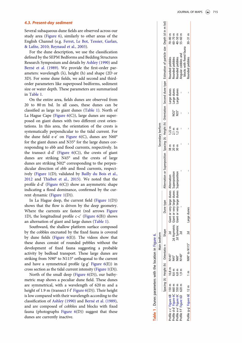
Several subaqueous dune fields are observed across ourstudy area (Figure 6), similarly to other areas of theEnglish Channel (e.g. Ferret, Le Bot, Tessier, Garlan,& Lafite, 2010; Reynaud et al., 2003).
For the dune description, we use the classificationdefined by the SEPM Bedforms and Bedding StructuresResearch Symposium and details by Ashley (1990) andBerné et al. (1989). We provide the first-order par-ameters: wavelength (λ), height (h) and shape (2D or3D). For some dune fields, we add second and third-order parameters like superposed bedforms, sedimentsize or water depth. These parameters are summarizedin Table 1.
On the entire area, fields dunes are observed from20 to 80 m bsl. In all cases, these dunes can beclassified as large to giant dunes (Table 1). North ofLa Hague Cape (Figure 6(C)), large dunes are super-posed on giant dunes with two different crest orien-tations. In this area, the orientation of the crests issystematically perpendicular to the tidal current. Forthe dune field e-e′ on Figure 6(C), dunes are N60°for the giant dunes and N35° for the large dunes cor-responding to ebb and flood currents, respectively. Inthe transect d-d′ (Figure 6(C)), the crests of giantdunes are striking N45° and the crests of largedunes are striking N02° corresponding to the perpen-dicular direction of ebb and flood currents, respect-ively (Figure 1(D); validated by Bailly du Bois et al.,2012 and Thiébot et al., 2015). We noted that theprofile d-d′ (Figure 6(C)) show an asymmetric shapeindicating a flood dominance, confirmed by the cur-rent dynamic (Figure 1(D)).
In La Hague deep, the current field (Figure 1(D))shows that the flow is driven by the deep geometry.Where the currents are fastest (red arrows Figure1D), the longitudinal profile c-c′ (Figure 6(B)) showsan alternation of giant and large dunes (Table 1).
Southward, the shallow platform surface composedby the cobbles encrusted by the fixed fauna is coveredby dune fields (Figure 6(E)). The videos show thatthese dunes consist of rounded pebbles without thedevelopment of fixed fauna suggesting a probableactivity by bedload transport. These large dunes arestriking from N90° to N115° orthogonal to the currentand have a symmetrical profile (g-g′ Figure 6(E)) incross section as the tidal current intensity (Figure 1(D)).
North of the small deep (Figure 6(D)), our bathy-metric map shows a peculiar dune field. These dunesare symmetrical, with a wavelength of 620 m and aheight of 1.9 m (transect f-f′ Figure 6(D)). Their heightis low compared with their wavelength according to theclassification of Ashley (1990) and Berné et al. (1989),and are composed of cobbles and blocks with fixedfauna (photographs Figure 6(D)) suggest that thesedunes are currently inactive.
Table1.D
unes
parameterswith
thelocatio
nin
Figu
re6.
Mainbedform
Second
aryberform
Estim
ationof
particlesize
Depth
(din
mbsl)
Spacing(λ)Heigh
t(h)
Orientatio
nShape
Dunetype
Alternationor
Superposition
Spacing(λ)Heigh
t(h)Orientation
Second
dune
type
Profilec-c′Figu
re6B
150m
10,8m
N145°
2dGiant
orvery
largedu
nesAlternation
38m
1,22
mLargedu
nes
Roundedpebb
les
70–80m
Profiled-d′
Figu
re6C
660m
8,6m
N45°
2dAsym
etric
Giant
orvery
largedu
nesSuperposition
20m
2,1m
NO2°
Largedu
nes
Roundedpebb
les
60–70m
Profilee-e′
Figu
re6C
550m
6,8m
N60°
2dSymetric
Giant
orvery
largedu
nesSuperposition
30m
1,2m
N35°
Largedu
nes
Roundedpebb
les
40–50m
Profilef-f
′ Figure6D
620m
1,9m
N140°
2d–
––
––
–An
gularcobb
lesand
blocks
with
fiwed
fauna
55–60m
Profileg-g′
Figu
re6E
12m
1m
N90°to
N115°
2dLargedu
nes
––
––
–Roundedpebb
les
30–31m
JOURNAL OF MAPS 715

As mapped on the Shom database, sediments arerelatively rare in the area of maximum velocity. How-ever, except for the last dune field, dunes are composedof rounded pebbles (photographs Figure 6(B,C and E)),mainly of flint rocks suggesting the presence of sedi-ment available for transport (located on the final mapby fine yellow and blue lines). In addition, we observerounded pebbles in fractures in the crystalline rocks.These fractures creating large depressions (up to200 m²) are identified on the bathymetric map byblury zones (Figure 4(B)). And finally, we found largeboulders, pebbles and sand at the foot of the scarp
separating the shallow and the deep domain. The lar-gest blocks are probably derived from the scarp andtransported by gravitational processes. The finer sedi-ments may move northward during the flood andsouthward during the ebb. However, the 15–50 mhigh scarp acts as a barrier for the coarse sediments.
5. Conclusions
Our new bathymetric map coupled with video acqui-sition at the sea floor, sediment samples, bathymetricmorphology interpretations and onshore-offshore
Figure 7. Non-exhaustive geological-sedimentary-dynamic map. The BRGM geological map is used for the onshore part andinterpretations from our videos, Shipek samples and bathymetric map for the offshore part. The samples points are added andare colored according the dynamic dominance (mobile or sediments covered by fixed fauna).
716 L. FURGEROT ET AL.
correlations allows the building of a new geologic andsedimentologic map of Alderney Race (Figure 7). Themain results highlighted by this map are summarizedbelow.
. The shallow platform (from 0 to 35 m depth) ischaracterized by Proterozoic crystalline rocks andPaleozoic sedimentary rocks, partially outcropping.The Paleozoic sedimentary rocks are exposed inthe Jobourg and Siouville Synclines that extendfrom offshore areas to the Cotentin Peninsula.
. The deep domain (from 50 m up to 90 m bsl) ischaracterized by Upper Cretaceous chalk exposures.In this domain, two distinct troughs are identified:the La Hague deep and a secondary small deep.The La Hague deep results of fluvial incision by aQuaternary paleo-tributary of the Seine River(Antoine et al., 2003). The small deep may be theresult of karstic processes affecting the Cretaceouschalk, during the Pliocene-Pleistocene lowstands.
. The deep domain and the shallow platform are sep-arated by a 15–50 m high scarp that belongs to theAlderney – La Hague fault zone, described as anactive fault during the Quaternary (Lagarde et al.,2003).
. In several places, a coarse sedimentary cover isfound dominated by angular cobbles and boulderscovered by fixed fauna. These sediments are inter-preted as Quaternary periglacial slope deposits andcorestones resulting in cryofracturation of thebedrock.
. Up to four dune fields are identified on our map andthe highest dunes are up to 10.8 m high in the LaHague deep. These dunes are commonly composedof pebbles and are orthogonal to the current direc-tions calculated from the MARS2D regionalmodel. The orientation of the dunes is partially dri-ven by the La Hague deep that controls the orien-tation of strong tidal currents. Conversely, thestrong currents prevent the filling of the La Haguedeep, preserving the bathymetry.
. Small patches of fine-grained and possibly mobilesediments are mapped in protected areas as in theVauville, Ecalgrain or Saint-Martin bays. Similarsediments are observed using the underwater videosin fractures in the substrate and between the cobblesand boulders.
. Our map shows a complex bathymetry with severalfeatures at the sea floor, such as corestones, thermo-karstic depressions and large dunes. Although theMARS2D numerical model (resolution of 100 m)gives consistent results on average flow directionand intensity at the regional scale, future higher res-olution models for turbulence estimation may takeinto account the complex bathymetry described inthis paper. For example, the 15–50 m scarp relatedwith the Alderney – La Hague fault zone may
generate strong hydrodynamic effects in the watercolumn, during the ebb, as it creates a steep barrierorthogonal to the ebb currents.
Acknowledgements
Authors acknowledge the crews of the ocean research vesselsthe CNRS vessels ‘Côtes de la Manche’ and ‘Haliotis’.Authors acknowledge the head of the research project,Anne-Claire Bennis (UNICAEN) and the crews of theocean research CNRS vessel ‘Côtes de la Manche’. Authorsalso acknowledge the three reviewers P Bessin, C. Ortonand A. Trenteseaux for their interesting critics and com-ments that greatly improve the manuscript.
Disclosure statement
No potential conflict of interest was reported by the authors.
Funding
This work was supported by the HYD2M project [ANR-10-IEED-0006-07] funded by the program called ‘Investisse-ments d’avenir’ for the building of France Energies Marines,the Oceanquest project from Hydroquest and the depart-ment council of Manche; Agence Nationale de la Recherche.
Software
The high-resolution bathymetry has been processedwith QGIS. Final editing of other figures was per-formed using InkScape.
References
Antoine, P., Coutard, J.-P., Gibbard, P., Hallegouet, B.,Lautridou, J.-P., & Ozouf, J.-C. (2003). The Pleistocenerivers of the English Channel region. Journal ofQuaternary Science, 18(3–4), 227–243. doi:10.1002/jqs.762
Ashley, G. M. (1990). Classification of large-scale subaqu-eous bedforms: A new look at an old problem. Journalof Sedimentary Research, 60, 160–172. doi:10.2110/JSR.60.160
Bailly du Bois, P. (2008). BATHAGUE 2008 cruise, RVHaliotis. doi.org/10.17600/8120080
Bailly du Bois, P., Dumas, F., Solier, L., & Voiseux, C. (2012).In-situ database toolbox for short-term dispersion modelvalidation in macro-tidal seas, application for 2D-model.Continental Shelf Research, 36, 63–82. doi:10.1016/j.csr.2012.01.011
Ballèvre, M., Bosse, V., Ducassou, C., & Pitra, P. (2009).Palaeozoic history of the Armorican Massif: Models forthe tectonic evolution of the suture zones. ComptesRendus Geoscience, 341, 174–201. doi:10.1016/j.crte.2008.11.009
Ballèvre, M., Le Goff, E., & Hébert, R. (2001). The tecto-nothermal evolution of the Cadomian belt of northernBrittany: A Neoproterozoic volcanic arc. Tectonophysics,331, 19–43. doi:10.1016/S0040-1951(00)00234-1
Benabdelhouahed, M. (2011). La Seine fluviatile plio-quater-naire en baie de Seine: évolution morphologique etsédimentaire (rôle du substratum géologique et des cycles
JOURNAL OF MAPS 717

climato-eustatiques) (PhD). University of Caen, France,355 pp.
Berné, S., Allen, G., Auffret, J. P., Chamley, H., Durand, J., &Weber, O. (1989). Essai de synthèse sur les dunes hydrau-liques géantes tidales actuelles. Bulletin de la SociétéGéologique de France, 6, 1145–1160. doi:10.2113/gssgfbull.V.6.1145
Bessin, P., Guillocheau, F., Robin, C., Schroëtter, J.-M., &Bauer, H. (2015). Planation surfaces of the ArmoricanMassif (western France): Denudation chronology of aMesozoic land surface twice exhumed in response to rela-tive crustal movements between Iberia and Eurasia.Geomorphology, 233, 75–91. doi:10.1016/j.geomorph.2014.09.026
Chantraine, J., Egal, E., Thiéblemont, D., Goff, E. L., Guerrot,C., Ballèvre, M., & Guennoc, P. (2001). The Cadomianactive margin (North Armorican Massif, France): a segmentof the North Atlantic Panafrican belt. Tectonophysics, 331,1–18. doi:10.1016/S0040-1951(00)00233-X
Coles, D.-S., Blunden, L.-S., & Bahaj, A.-S. (2017).Assessment of the energy extraction potential at tidalsites around the Channel Islands. Energy, 124, 171–186.doi:10.1016/j.energy.2017.02.023
Dallmeyer, R. D., D’Lemos, R. S., Strachan, R. A., & Mueller,P. A. (1991). Tectonothermal chronology of earlyCadomian arc development in Guernsey and Sark,Channel Islands. Journal of the Geological Society,Geological Society of London, 148, 691–702. doi:10.1144/gsjgs.148.4.0691
Dissler, E., & Gresselin, F. (1988). The North Cotentin shear-zone (Normandy-France): Variscan mobilization of thecadomian basement and its palaeozoic cover. GeologicalJournal, 23, 191–204. doi:10.1002/gj.3350230301
Doré, F., Dupret, L., Le Gall, J., & Chalot-Prat, F. (1977).Notice explicative, Carte géologique de France (scale1:50 000), feuille La Ferté - Macé (250). BRGM, Orléans,France, 31 pp. Geological map by Doré, F., Dupret, L.,Le Gall, J., Chalot-Prat, F.
Dugué, O. (2007). Le Massif armoricain dans l’évolutionmésozoïque et cénozoïque du nord-ouest de l’Europe -Contrôles tectonique, eustatique et climatique d’un bassinintracratonique (Normandie, mer de la Manche, France).Mémoire d’Habilitation à Diriger les Recherches (HDR)de l’Université de Caen Basse-Normandie, and Mémoiresde Géosciences Rennes (2007), Hors-série 6, 346 pp.
Ferret, Y., Le Bot, S., Tessier, B., Garlan, T., & Lafite, R.(2010). Migration and internal architecture of marinedunes in the eastern English Channel over 14 and 56year intervals: The influence of tides and decennialstorms. Earth Surface Processes and Landforms, 35,1480–1493. doi:10.1002/esp.2051
Font, M., Lagarde, J.-L., Amorese, D., Coutard, J.-P., &Ozouf, J.-C. (2002). Une méthode de quantification dela dégradation d’un escarpement de faille au cours descycles climatiques du Quaternaire: La faille de Jobourg(Nord Cotentin, France). Comptes Rendus Geoscience,334, 171–178.
Foveau, A., & Dauvin, J.-C. (2017). Surprisingly diversifiedmacrofauna in mobile gravels and pebbles from high-
energy hydrodynamic environment of the ‘RazBlanchard’ (English Channel). Regional Studies inMarine Science, 16, 188–197. doi:10.1016/j.rsma.2017.08.011
Hjulström, F. (1935). Studies of the morphological activity ofrivers as illustrated by the river Fyris. Bulletin of theGeological Institute of Uppsala, 25, 221–527.
Hommeril, P. (1967). Étude de géologie marine concernant lelittoral bas-normand et la zone pré-littorale de l’archipelanglo-normand. (PhD). University of Caen, France. 304pp.
Inglis, J. D., Samson, S. D., D’Lemos, R. S., & Miller, B. V.(2005). Timing of Cadomian deformation and magma-tism within La Hague, NW France. Journal of theGeological Society, 162, 389–400. doi:10.1144/0016-764904-006
Lagarde, J.-L., Amorese, D., Font, M., Laville, E., & Dugué, O.(2003). The structural evolution of the English Channelarea. Journal of Quaternary Science, 18, 201–213. doi:10.1002/jqs.744
Lagarde, J.-L., Baize, S., Amorese, D., Delcaillau, B., Font, M.,& Volant, P. (2000). Active tectonics, seismicity and geo-morphology with special reference to Normandy (France).Journal of Quaternary Science, 15, 745–758. doi:10.1002/1099-1417(200010)
Larsonneur, C., Bouysse, P., & Auffret, J.-P. (1982). Thesuperficial sediments of the English Channel and itsWestern Approaches. Sedimentology, 29, 851–864.doi:10.1111/j.1365-3091.1982.tb00088.x
Larsonneur, C., & Walker, P. (1982). Le Golfe Normand-Breton: Synthèse sédimentologique. https://archimer.ifremer.fr/doc/00047/15843/
Lericolais, G. (1997). Evolution du fleuve Manchedepuis l’Oligocène: stratigraphie et géomorphologied’une plateforme continentale en régime périglaciaire.(PhD). University of Bordeaux, France. 248 pp.
Pedoja, K., Jara-Muñoz, J., De Gelder, G., Robertson, J.,Meschis, M., Fernandez-Blanco, D.,… Pinel, B. (2018).Neogene-Quaternary slow coastal uplift of WesternEurope through the perspective of sequences of stran-dlines from the Cotentin Peninsula (Normandy,France). Geomorphology, 303, 338–356. doi:10.1016/j.geomorph.2017.11.021
Reynaud, J.-Y., Tessier, B., Auffret, J.-P., Berné, S., Batist, M.D., Marsset, T., & Walker, P. (2003). The offshoreQuaternary sediment bodies of the English Channel andits Western Approaches. Journal of Quaternary Science,18, 361–371. doi:10.1002/jqs.758
Shom. (2015). MNT Bathymétrique de façade Atlantique(Projet Homonim). doi:10.17183/MNT_ATL100m_HOMONIM_WGS84
Shom-ROLNP. (2018). doi:10.17183/LIDAR_NHDF_V20180501
Thiébot, J., Bailly du Bois, P., & Guillou, S. (2015). Numericalmodeling of the effect of tidal stream turbines on thehydrodynamics and the sediment transport –Application to the Alderney Race (Raz Blanchard),France. Renewable Energy, 75, 356–365. doi:10.1016/j.renene.2014.10.021
718 L. FURGEROT ET AL.