1
ASSOCIATE PARTNERS PARTNERS In December 2007 the European Parliament and Council adopted the Marine Strategy Framework Directive (MSFD) which aims to achieve environmentally healthy marine waters by 2020. This Directive includes an initiative for an overarching European Marine Observation and Data Network (EMODnet). The EMODnet Hydrography - Seabed Mapping - Bathymetry projects made very good progress in developing the EMODnet Bathymetry portal to provide overview and access to available bathymetric survey datasets and to generate an harmonised digital bathymetry for Europe’s sea basins. Up till February 2016 more than 13.500 bathymetric survey datasets, managed by 27 data centres from 14 countries and originated from 167 institutes, have been gathered and populated in the EMODnet Bathymetry Data Discovery and Access service, adopting SeaDataNet standards. In addition a number of data providers have delivered composite DTMs as alternative to survey data sets and these are populated with metadata in the EMODnet Sextant Catalogue service. From these circa 7000 survey data sets and 30 composite DTMs together have been used as input for analysing and generating the EMODnet digital terrain model (DTM), for the following sea basins: • the Greater North Sea, including the Kattegat and stretches of water such as Fair Isle, Cromarty, Forth, Forties, Dover, Wight, and Portland • the English Channel and Celtic Seas • Western and Central Mediterranean Sea and Ionian Sea • Bay of Biscay, Iberian coast and North-East Atlantic • Adriatic Sea • Aegean - Levantine Sea (Eastern Mediterranean) • Azores - Madeira EEZ • Canary Islands • Baltic Sea • Black Sea • Norwegian – Icelandic seas Gaps in coverage by survey data sets and composite DTMs are completed by using the GEBCO – 2014 DTM data. GEBCO ( General Bathymetric Chart of the Oceans) is partner in the project, while for the Baltic Sea synergy takes place with the Baltic Sea Bathymetry Database project of the Baltic Sea Hydrographic Commission. The Bathymetry Viewing and Download service gives users wide functionality for viewing and downloading the EMODnet digital bathymetry: • water depth in gridded form on a DTM grid of 1/8 * 1/8 arc minute of longitude and latitude (ca 230 * 230 meters) • option to view depth parameters of individual DTM cells and references to source data • option to download DTM in 16 tiles in different formats: ESRI ASCII, XYZ, EMODnet CSV, NetCDF (CF), GeoTiff and SD • option for users to create their Personal Layer and to upload multibeam survey ASCII datasets for automatic processing into personal DTMs following the EMODNet standards • layer with a number of high resolution DTMs for coastal regions • layer with wrecks from the UKHO Wrecks database. The NetCDF (CF) DTM files are fit for use in a special 3D Viewer software package which is based on the existing open source NASA World Wind JSK application. It has been developed in the frame of the EU FP7 Geo-Seas project (another sibling of SeaDataNet for marine geological and geophysical data) and is freely available. The 3D viewer also supports the ingestion of WMS overlay maps. The SD files can also be used for 3D viewing by means of the freely available iView4D (Fledermaus) software. Figure 3: 3D Viewer - example view for the EMODnet DTM A new release of the EMODnet DTM is planned for summer 2016 integrating more data sets and refining areas with possible anomalies. The EMODnet consortium is actively seeking cooperation with additional Hydrographic Offices, research institutes, authorities and private organisations for more data sets (single and multi- beam surveys, sounding tracks, composite products) to contribute to an even better geographical coverage. These datasets will be used for upgrading and extending the EMODnet DTM. The datasets themselves are not distributed but described in the metadata services, giving clear information about the background survey data used for the DTM, their access restrictions, originators and distributors and facilitating requests by users to originators. This way the portal provides originators of bathymetric data sets an attractive shop window for promoting their data sets to potential users, without losing control. VISIT US AT: WWW.EMODNET-BATHYMETRY.EU Figure 1: CDI Data Discovery and Access Service - overview of selected survey data sets Figure 2: Bathymetry Viewing and Download service - layers menu and layer indicating data sources used for the resulting DTM EMODNET HYDROGRAPHY - SEABED MAPPING - BATHYMETRY PROJECTS PRODUCING A HIGH RESOLUTION DIGITAL BATHYMETRY FOR EUROPEAN SEA BASINS Figure 4: Bathymetry Viewing and Download service - example for retrieving depth and depth profile

EMODNET HYDROGRAPHY - SEABED MAPPING - BATHYMETRY … · The EMODnet Hydrography - Seabed Mapping - Bathymetry projects made very good progress in developing the EMODnet Bathymetry

  • Upload
    others

  • View
    21

  • Download
    0

Embed Size (px)

Citation preview

ASSOCIATE PARTNERS

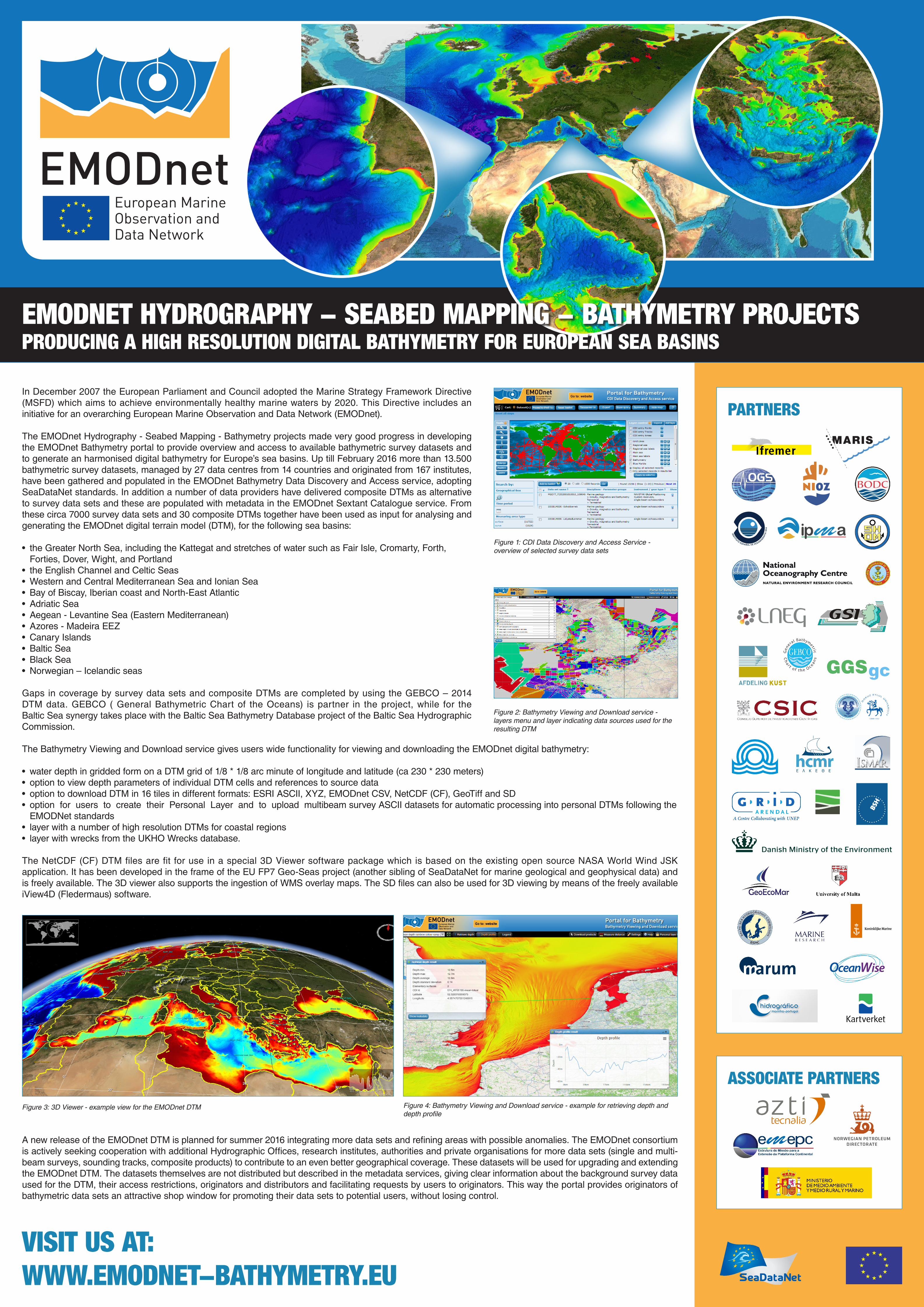
PARTNERSIn December 2007 the European Parliament and Council adopted the Marine Strategy Framework Directive (MSFD) which aims to achieve environmentally healthy marine waters by 2020. This Directive includes an initiative for an overarching European Marine Observation and Data Network (EMODnet).

The EMODnet Hydrography - Seabed Mapping - Bathymetry projects made very good progress in developing the EMODnet Bathymetry portal to provide overview and access to available bathymetric survey datasets and to generate an harmonised digital bathymetry for Europe’s sea basins. Up till February 2016 more than 13.500 bathymetric survey datasets, managed by 27 data centres from 14 countries and originated from 167 institutes, have been gathered and populated in the EMODnet Bathymetry Data Discovery and Access service, adopting SeaDataNet standards. In addition a number of data providers have delivered composite DTMs as alternative to survey data sets and these are populated with metadata in the EMODnet Sextant Catalogue service. From these circa 7000 survey data sets and 30 composite DTMs together have been used as input for analysing and generating the EMODnet digital terrain model (DTM), for the following sea basins:

• the Greater North Sea, including the Kattegat and stretches of water such as Fair Isle, Cromarty, Forth, Forties, Dover, Wight, and Portland

• the English Channel and Celtic Seas• Western and Central Mediterranean Sea and Ionian Sea• Bay of Biscay, Iberian coast and North-East Atlantic• Adriatic Sea• Aegean - Levantine Sea (Eastern Mediterranean)• Azores - Madeira EEZ• Canary Islands• Baltic Sea• Black Sea• Norwegian – Icelandic seas

Gaps in coverage by survey data sets and composite DTMs are completed by using the GEBCO – 2014 DTM data. GEBCO ( General Bathymetric Chart of the Oceans) is partner in the project, while for the Baltic Sea synergy takes place with the Baltic Sea Bathymetry Database project of the Baltic Sea Hydrographic Commission.

The Bathymetry Viewing and Download service gives users wide functionality for viewing and downloading the EMODnet digital bathymetry:

• water depth in gridded form on a DTM grid of 1/8 * 1/8 arc minute of longitude and latitude (ca 230 * 230 meters)• option to view depth parameters of individual DTM cells and references to source data• option to download DTM in 16 tiles in different formats: ESRI ASCII, XYZ, EMODnet CSV, NetCDF (CF), GeoTiff and SD • option for users to create their Personal Layer and to upload multibeam survey ASCII datasets for automatic processing into personal DTMs following the

EMODNet standards• layer with a number of high resolution DTMs for coastal regions• layer with wrecks from the UKHO Wrecks database.

The NetCDF (CF) DTM files are fit for use in a special 3D Viewer software package which is based on the existing open source NASA World Wind JSK application. It has been developed in the frame of the EU FP7 Geo-Seas project (another sibling of SeaDataNet for marine geological and geophysical data) and is freely available. The 3D viewer also supports the ingestion of WMS overlay maps. The SD files can also be used for 3D viewing by means of the freely available iView4D (Fledermaus) software.

Figure 3: 3D Viewer - example view for the EMODnet DTM

A new release of the EMODnet DTM is planned for summer 2016 integrating more data sets and refining areas with possible anomalies. The EMODnet consortium is actively seeking cooperation with additional Hydrographic Offices, research institutes, authorities and private organisations for more data sets (single and multi-beam surveys, sounding tracks, composite products) to contribute to an even better geographical coverage. These datasets will be used for upgrading and extending the EMODnet DTM. The datasets themselves are not distributed but described in the metadata services, giving clear information about the background survey data used for the DTM, their access restrictions, originators and distributors and facilitating requests by users to originators. This way the portal provides originators of bathymetric data sets an attractive shop window for promoting their data sets to potential users, without losing control.

VISIT US AT:WWW.EMODNET-BATHYMETRY.EU

Figure 1: CDI Data Discovery and Access Service - overview of selected survey data sets

Figure 2: Bathymetry Viewing and Download service - layers menu and layer indicating data sources used for the resulting DTM

EMODNET HYDROGRAPHY - SEABED MAPPING - BATHYMETRY PROJECTSPRODUCING A HIGH RESOLUTION DIGITAL BATHYMETRY FOR EUROPEAN SEA BASINS

Figure 4: Bathymetry Viewing and Download service - example for retrieving depth and depth profile