Embed Size (px)
Citation preview

10.04.2012 1 KL Geir Roar Bakken
FORSVARET FORSVARET
GPS Global Positioning System

10.04.2012 2 KL Geir Roar Bakken
FORSVARET
Agenda • What is GPS?
– Basic consept
– History
• GPS receivers – How they work
• Comunication – Message format
– Satellite frequencies
– Sources of GPS signal errors

10.04.2012 3 KL Geir Roar Bakken
FORSVARET
What is GPS • Global Positioning System
– Satellite-based navigation system
– Used in aviation, nautical navigation and for the orientation ashore.
– Can be used by any person with a GPS receiver.
– 32 satellites in orbit, 20180 km above us • 6 different orbital planes
– Each satellite orbits the Earth in 12 hours
– At least 4 satellites are in radio comms with any point on earth
• Powered by solar energy
• Backup batteries to keep them running in the event of solar eclipse
• Small rocket boosters – keep them flying in correct path
• 4 atomic clocks onboard
– Orginally intended for military applications

10.04.2012 4 KL Geir Roar Bakken
FORSVARET
What is GPS History
• American Department of Defence (DOD)
• NAVSTAR-GPS
• One of 4 different Global Navigation Satellite Systems (GNSS)

10.04.2012 5 KL Geir Roar Bakken
FORSVARET
What is GPS Basic Consept of satellite navigation

10.04.2012 6 KL Geir Roar Bakken
FORSVARET
What is GPS Basic Consept of satellite navigation
Position of the GPS satellites at 12:00 hrs UTC on 14th April 2001

10.04.2012 7 KL Geir Roar Bakken
FORSVARET
What is GPS Basic Consept of satellite navigation
•GPS receivers use triangulation to calculate
the users exact location.
•Compares transmit time – received time
•Satellites with a known position
transmit a regular time signal.
•Based on the measured travel time
of the radio waves (electromagnetic
signals travel through space at the
speed of light) the position of the
receiver is calculated
•3 satellites:2D(lat/long) track
movement
•4 or more satellites: 3D
(lat/long/altitude)
•GPS unit can calculate:
•Speed, bearing, track, distance
to destination etc.
10.04.2012 8 KL Geir Roar Bakken
FORSVARET
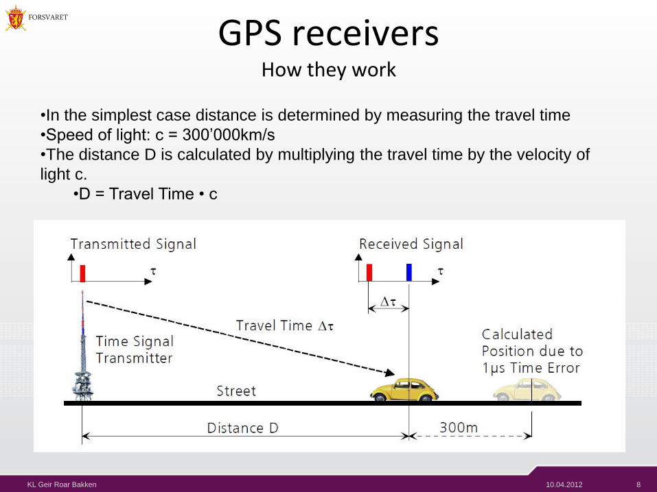
GPS receivers How they work
•In the simplest case distance is determined by measuring the travel time
•Speed of light: c = 300’000km/s
•The distance D is calculated by multiplying the travel time by the velocity of
light c.
•D = Travel Time • c

10.04.2012 9 KL Geir Roar Bakken
FORSVARET
GPS receivers •With two transmitters it is possible to calculate the exact position despite time
errors.
•It is necessary that the number of time signal transmitters exceed the number
of unknown dimensions by a value of one.

10.04.2012 10 KL Geir Roar Bakken
FORSVARET
GPS receivers •Four satellites are needed to determine longitude, latitude, altitude and time

10.04.2012 11 KL Geir Roar Bakken
FORSVARET
GPS Determining position

10.04.2012 12 KL Geir Roar Bakken
FORSVARET
Communication Message format
GPS message format
Subframes Description
1 Satellite clock,
GPS time relationship
2–3 Ephemeris
(precise satellite orbit)
4–5
Almanac component
(satellite network synopsis,
error correction)
•Basic format: 1500bit long frame
•5 subframes, 300 bits (6s) each
•Complete message requires 25 full
frames. Total 37,500 bits long.
•Transmission rate 50bps; 750
seconds to transmit an entire
almanac message.
•Receiver must demodulate the
message from each satellite it
includes in its solution for 18-30
seconds.
•Collect all transmitted almanacs
the receiver must demodulate the
message for 732 to 750 seconds.

10.04.2012 13 KL Geir Roar Bakken
FORSVARET
Communication Satellite frequencies
GPS frequency overview
Band Frequency Description
L1 1575.42 MHz
Coarse-acquisition
(C/A) and encrypted
precision P(Y) codes,
plus the L1 civilian
(L1C) and military
(M) codes on future
Block III satellites.
L2 1227.60 MHz
P(Y) code, plus
the L2C and military
codes on the Block
IIR-M and newer
satellites.
L3 1381.05 MHz Used for nuclear
detonation (NUDET)
detection.
L4 1379.913 MHz
Being studied for additional ionospheric correction.[citation needed]
L5 1176.45 MHz Proposed for use as a
civilian safety-of-life
(SoL) signal.
•CDMA
•Unique encodings PRN
(high-rate pseudo-random
encoding):
•Coarse/acquisition(C/A)
•Precise (P) code
•Encrypted (U.S.m)
•Two separate carrier frequencies
(L1, L2) (UHF band)
•Public
•U.S. military
•Both the C/A and P(Y) codes
impart the precise time of day to
the user.

10.04.2012 14 KL Geir Roar Bakken
FORSVARET
GPS receiver demodulation and decoding
•How does GPS receivers separate
GPS satellite signals when signals
are modulated onto the same L1
carrier frequency?
•Signal separation:
•Gold code •Unique binary sequence

10.04.2012 15 KL Geir Roar Bakken
FORSVARET
Communication Sources of GPS signal errors
• Ionosphere and troposphere delays
• Signal multipath
• Receiver clock errors
• Orbital errors
• Satellites visibility
• Satellite geometry/shading
• Intentional degradation of the satellite signal

10.04.2012 16 KL Geir Roar Bakken
FORSVARET
GPS • Resources and further readings:
– GPS - Essentials of Satellite Navigation • http://www.u-blox.com/images/downloads/Product_Docs/GPS_Compendium%28GPS-X-
02007%29.pdf

10.04.2012 17 KL Geir Roar Bakken
FORSVARET
Q&A