Embed Size (px)
Citation preview
GPS – Backbone of ADS-BADS-B – Backbone of NGATS
Briefing to Colorado Springs ION
December 11, 2009
11 December 2009
Overview
• Introduction
• ADS-B “essential” and “critical” services
• Navigation accuracy, integrity, & probability of non-detected
integrity error
• Data links and spectrum
• ADS-B ground infrastructure deployment
• Summary
2
11 December 2009
What does ADS-B stand for?
• Automatic – aircraft & ground-based ADS-B equipment
automatically broadcasts ADS-B information
• Dependent – ADS-B depends on GNSS signals, possibly with
Flight Management System, for state vector
• Surveillance – unprecedented situational awareness of air
traffic for ADS-B aircraft and ATC
• Broadcast – ADS-B ground stations and aircraft periodically
broadcast navigation data and other flight information
3
GPS is backbone of ADS-B ADS-B is backbone of the
Next Generation Air Transportation System (NGATS)
11 December 2009
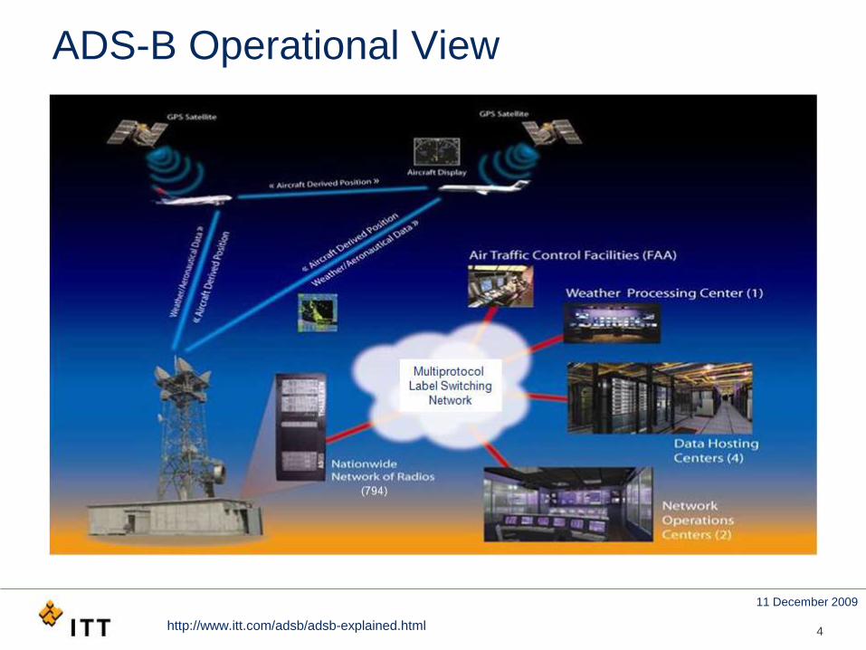
ADS-B Operational View
4http://www.itt.com/adsb/adsb-explained.html
11 December 2009
5
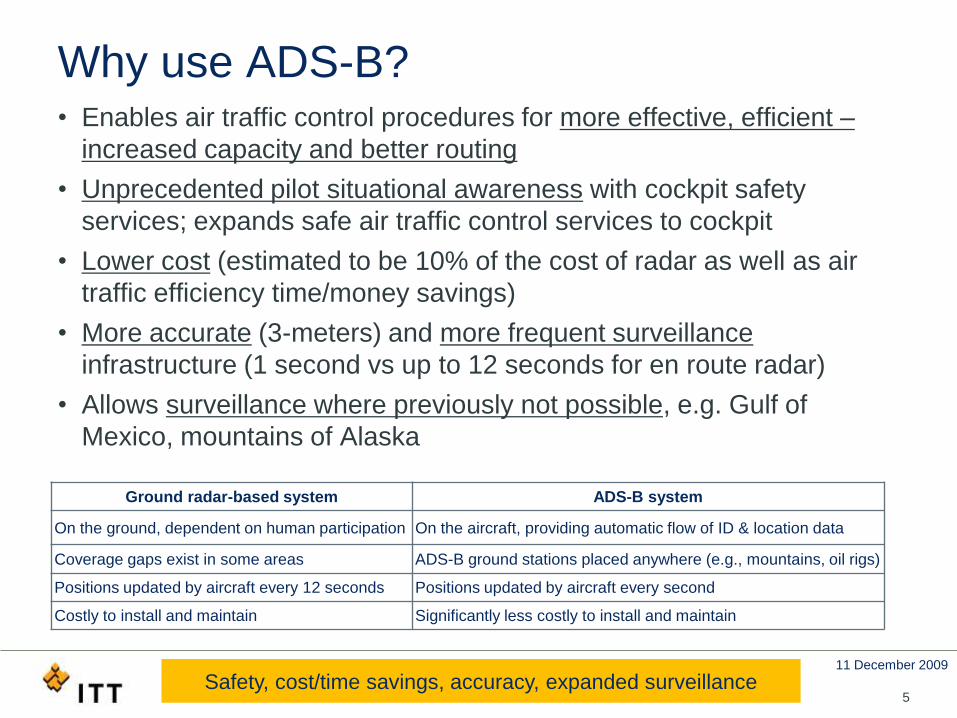
Why use ADS-B?• Enables air traffic control procedures for more effective, efficient –
increased capacity and better routing
• Unprecedented pilot situational awareness with cockpit safety
services; expands safe air traffic control services to cockpit
• Lower cost (estimated to be 10% of the cost of radar as well as air
traffic efficiency time/money savings)
• More accurate (3-meters) and more frequent surveillance
infrastructure (1 second vs up to 12 seconds for en route radar)
• Allows surveillance where previously not possible, e.g. Gulf of
Mexico, mountains of Alaska
Ground radar-based system ADS-B system
On the ground, dependent on human participation On the aircraft, providing automatic flow of ID & location data
Coverage gaps exist in some areas ADS-B ground stations placed anywhere (e.g., mountains, oil rigs)
Positions updated by aircraft every 12 seconds Positions updated by aircraft every second
Costly to install and maintain Significantly less costly to install and maintain
Safety, cost/time savings, accuracy, expanded surveillance
11 December 2009
6
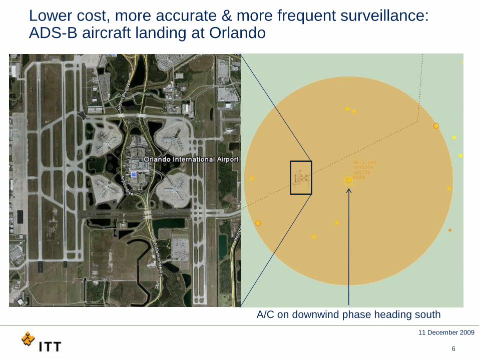
Lower cost, more accurate & more frequent surveillance:ADS-B aircraft landing at Orlando
A/C on downwind phase heading south
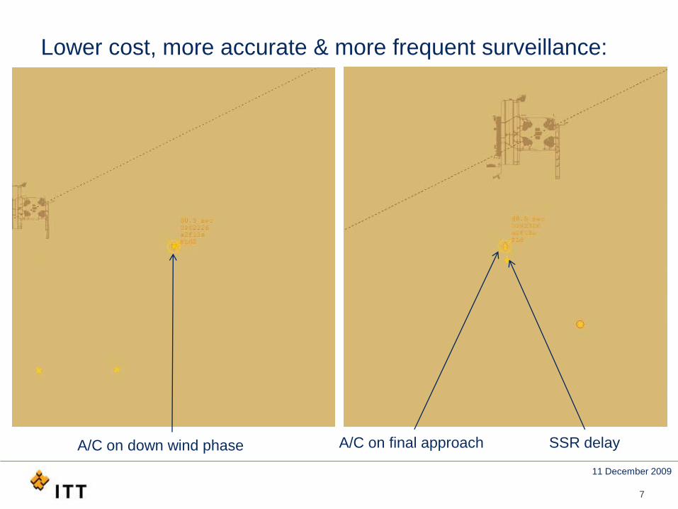
11 December 2009
7
Lower cost, more accurate & more frequent surveillance:
A/C on final approach SSR delayA/C on down wind phase
11 December 2009
8
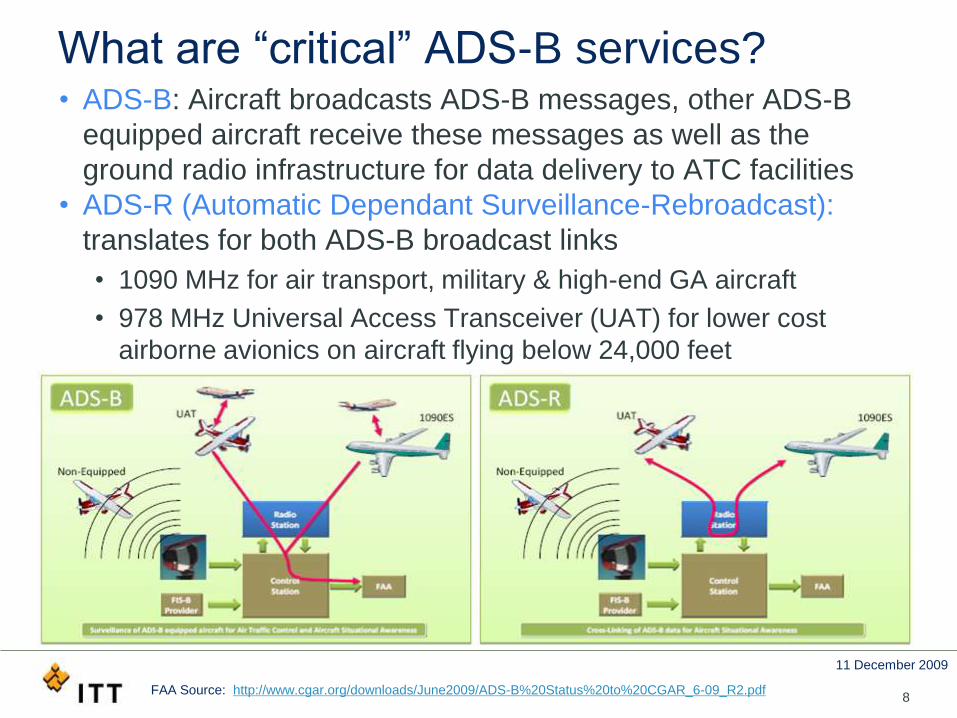
What are “critical” ADS-B services?• ADS-B: Aircraft broadcasts ADS-B messages, other ADS-B
equipped aircraft receive these messages as well as the
ground radio infrastructure for data delivery to ATC facilities
• ADS-R (Automatic Dependant Surveillance-Rebroadcast):
translates for both ADS-B broadcast links
• 1090 MHz for air transport, military & high-end GA aircraft
• 978 MHz Universal Access Transceiver (UAT) for lower cost
airborne avionics on aircraft flying below 24,000 feet
FAA Source: http://www.cgar.org/downloads/June2009/ADS-B%20Status%20to%20CGAR_6-09_R2.pdf
11 December 2009
9
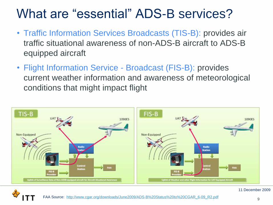
What are “essential” ADS-B services?
• Traffic Information Services Broadcasts (TIS-B): provides air
traffic situational awareness of non-ADS-B aircraft to ADS-B
equipped aircraft
• Flight Information Service - Broadcast (FIS-B): provides
current weather information and awareness of meteorological
conditions that might impact flight
FAA Source: http://www.cgar.org/downloads/June2009/ADS-B%20Status%20to%20CGAR_6-09_R2.pdf
11 December 2009
10
What is the TIS-B service?
• Traffic Information Services Broadcasts (TIS-B)
• ADS-B ground infrastructure ingests:
• All ADS-B broadcasts from aircraft
• FAA radar-based surveillance data for non ADS-B equipped
aircraft
• TIS-B service broadcasts TIS-B messages on 1090ES & UAT
• Provides ADS-B aircraft with situational awareness by
displaying data on all traffic in its proximity on a cockpit display
11 December 2009
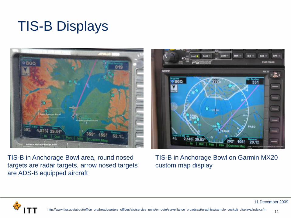
TIS-B Displays
11
TIS-B in Anchorage Bowl on Garmin MX20
custom map display
http://www.faa.gov/about/office_org/headquarters_offices/ato/service_units/enroute/surveillance_broadcast/graphics/sample_cockpit_displays/index.cfm
TIS-B in Anchorage Bowl area, round nosed
targets are radar targets, arrow nosed targets
are ADS-B equipped aircraft
11 December 2009
12
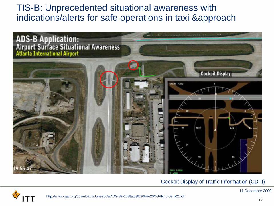
TIS-B: Unprecedented situational awareness with indications/alerts for safe operations in taxi &approach
Cockpit Display of Traffic Information (CDTI)
http://www.cgar.org/downloads/June2009/ADS-B%20Status%20to%20CGAR_6-09_R2.pdf
11 December 2009
13
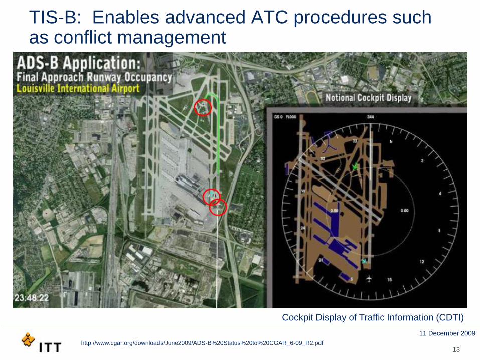
TIS-B: Enables advanced ATC procedures such as conflict management
Cockpit Display of Traffic Information (CDTI)
http://www.cgar.org/downloads/June2009/ADS-B%20Status%20to%20CGAR_6-09_R2.pdf
11 December 2009
14
What is the FIS-B service?
• Flight Information Service - Broadcast (FIS-B)
• ADS-B ground infrastructure ingests:
• Weather data
• Aeronautical data
• FIS-B service broadcasts FIS-B messages on UAT only
• Pilots have an understanding of all weather and aviation
system changes that might impact flight
11 December 2009
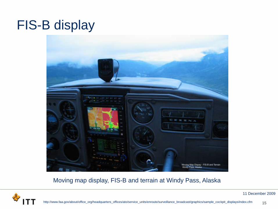
FIS-B display
15
Moving map display, FIS-B and terrain at Windy Pass, Alaska
http://www.faa.gov/about/office_org/headquarters_offices/ato/service_units/enroute/surveillance_broadcast/graphics/sample_cockpit_displays/index.cfm
11 December 2009
16
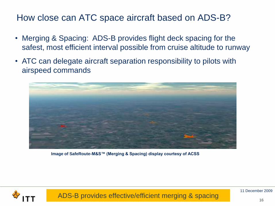
How close can ATC space aircraft based on ADS-B?
• Merging & Spacing: ADS-B provides flight deck spacing for the
safest, most efficient interval possible from cruise altitude to runway
• ATC can delegate aircraft separation responsibility to pilots with
airspeed commands
Image of SafeRoute-M&S™ (Merging & Spacing) display courtesy of ACSS
ADS-B provides effective/efficient merging & spacing
11 December 2009
GPS Accuracy & Integrity Parameters: NACp, NIC, and SIL
• Accuracy reflects nominal GPS performance; needed to
avoid collisions and issue associated alerts
• Navigation Accuracy Category for Position (NACp) specifies the
“Estimated Position Uncertainty” (EPU) with a 95% uncertainty bound
• Integrity reflects level of trust in GPS data; needed to
provide a safe aircraft separation assurance
• Navigation Integrity Category (NIC) specifies integrity containment region
characterized by horizontal radius of integrity containment (Rc or HPL)
• Probability of non-detected integrity errors; needed to
assess aircraft maneuver risks and mitigate or avoid
• Surveillance Integrity Limit (SIL) specifies the probability of exceeding the
NIC-specified integrity containment region
17NACp, NIC, and SIL
11 December 2009
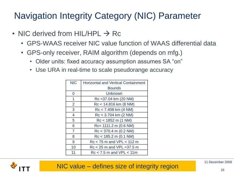
Navigation Integrity Category (NIC) Parameter
• NIC derived from HIL/HPL Rc
• GPS-WAAS receiver NIC value function of WAAS differential data
• GPS-only receiver, RAIM algorithm (depends on mfg.)
• Older units: fixed accuracy assumption assumes SA “on”
• Use URA in real-time to scale pseudorange accuracy
18
NIC Horizontal and Vertical Containment
Bounds
0 Unknown
1 Rc <37.04 km (20 NM)
2 Rc < 14.816 km (8 NM)
3 Rc < 7.408 km (4 NM)
4 Rc < 3.704 km (2 NM)
5 Rc < 1852 m (1 NM)
6 Rc< 1111.2 m (0.6 NM)
7 Rc < 370.4 m (0.2 NM)
8 Rc < 185.2 m (0.1 NM)
9 Rc < 75 m and VPL < 112 m
10 Rc < 25 m and VPL <37.5 m
11 Rc < 7.5 m and VPL < 11m
NIC value – defines size of integrity region
11 December 2009
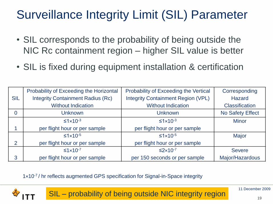
Surveillance Integrity Limit (SIL) Parameter
19
SIL
Probability of Exceeding the Horizontal
Integrity Containment Radius (Rc)
Without Indication
Probability of Exceeding the Vertical
Integrity Containment Region (VPL)
Without Indication
Corresponding
Hazard
Classification
0 Unknown Unknown No Safety Effect
1
≤1×10⁻³
per flight hour or per sample
≤1×10⁻³
per flight hour or per sample
Minor
2
≤1×10⁻⁵
per flight hour or per sample
≤1×10⁻⁵
per flight hour or per sample
Major
3
≤1×10⁻⁷
per flight hour or per sample
≤2×10⁻⁷
per 150 seconds or per sample
Severe
Major/Hazardous
1×10⁻⁷ / hr reflects augmented GPS specification for Signal-in-Space integrity
• SIL corresponds to the probability of being outside the
NIC Rc containment region – higher SIL value is better
• SIL is fixed during equipment installation & certification
SIL – probability of being outside NIC integrity region
11 December 2009
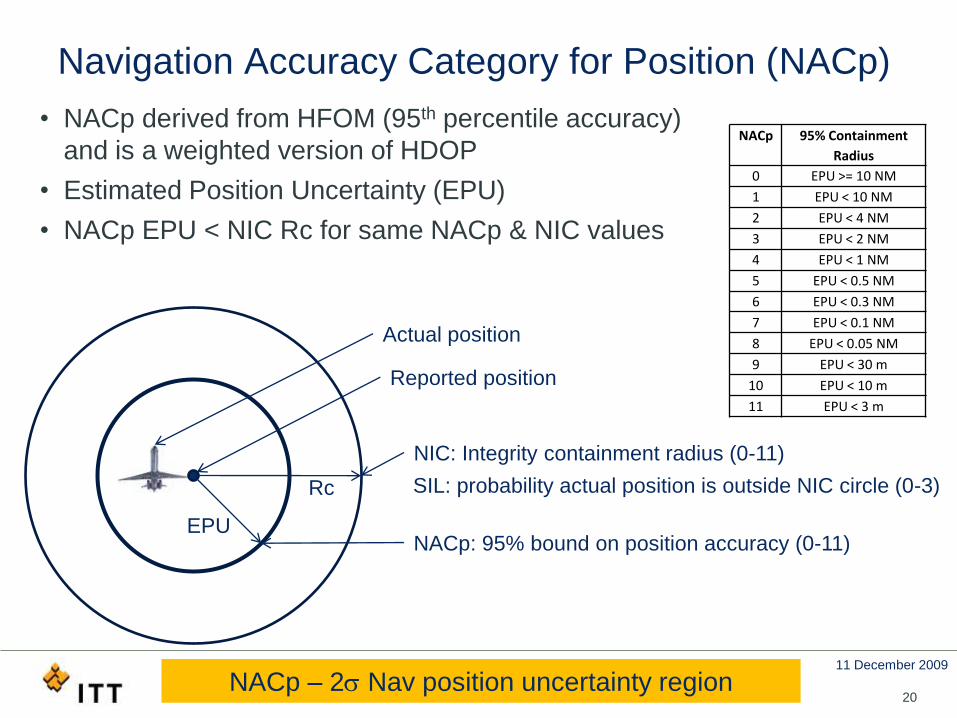
Navigation Accuracy Category for Position (NACp)
• NACp derived from HFOM (95th percentile accuracy)
and is a weighted version of HDOP
• Estimated Position Uncertainty (EPU)
• NACp EPU < NIC Rc for same NACp & NIC values
20
Actual position
Reported position
NACp: 95% bound on position accuracy (0-11)
Rc
NIC: Integrity containment radius (0-11)
SIL: probability actual position is outside NIC circle (0-3)
NACp 95% Containment
Radius
0 EPU >= 10 NM
1 EPU < 10 NM
2 EPU < 4 NM
3 EPU < 2 NM
4 EPU < 1 NM
5 EPU < 0.5 NM
6 EPU < 0.3 NM
7 EPU < 0.1 NM
8 EPU < 0.05 NM
9 EPU < 30 m
10 EPU < 10 m
11 EPU < 3 m
EPU
NACp – 2 Nav position uncertainty region
11 December 2009
GNSS position & Required Navigation Performance (RNP)
• RNP specifies the “navigation performance necessary for
operation within a defined airspace”
• Aircraft certification specifies an accuracy level, such as RNP 0.1
or RNP 0.3, at which the aircraft can navigate
• RNP X conveys that total Nav error ≤X NM 95% of the time
• RNP specifies Nav performance required to fly air routes
• RNP requires alerts if performance not being met
• GNSS is current, primary navigation system for RNP
21GNSS equipment values NACp, NIC-SIL support RNP
11 December 2009
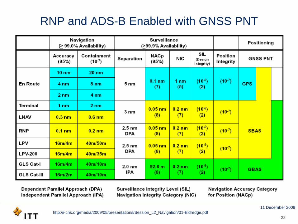
RNP and ADS-B Enabled with GNSS PNT
22
http://i-cns.org/media/2009/05/presentations/Session_L2_Navigation/01-Eldredge.pdf
11 December 2009
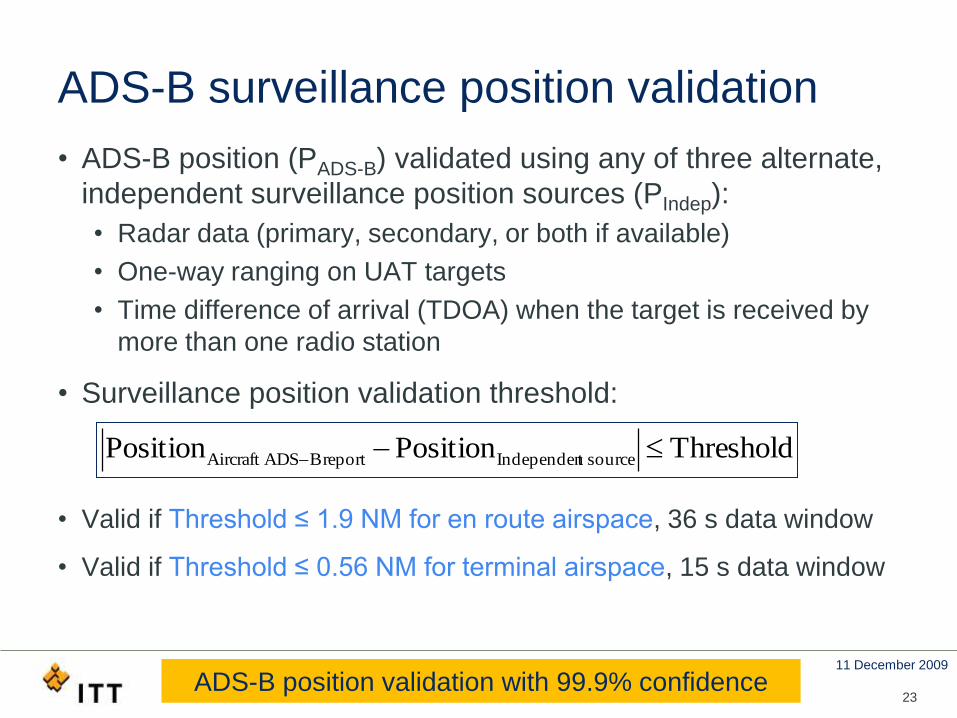
ADS-B surveillance position validation
• ADS-B position (PADS-B) validated using any of three alternate,
independent surveillance position sources (PIndep):
• Radar data (primary, secondary, or both if available)
• One-way ranging on UAT targets
• Time difference of arrival (TDOA) when the target is received by
more than one radio station
• Surveillance position validation threshold:
• Valid if Threshold ≤ 1.9 NM for en route airspace, 36 s data window
• Valid if Threshold ≤ 0.56 NM for terminal airspace, 15 s data window
ThresholdPositionPosition sourcetIndependenreportBADSAircraft
23ADS-B position validation with 99.9% confidence
11 December 2009
24
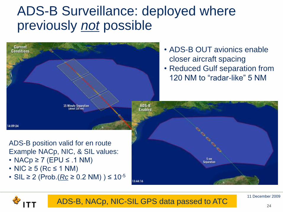
ADS-B Surveillance: deployed where previously not possible
• ADS-B OUT avionics enable
closer aircraft spacing
• Reduced Gulf separation from
120 NM to “radar-like” 5 NM
ADS-B position valid for en route
Example NACp, NIC, & SIL values:
• NACp ≥ 7 (EPU ≤ .1 NM)
• NIC ≥ 5 (Rc ≤ 1 NM)
• SIL ≥ 2 (Prob.(Rc ≥ 0.2 NM) ) ≤ 10-5
ADS-B, NACp, NIC-SIL GPS data passed to ATC
11 December 2009
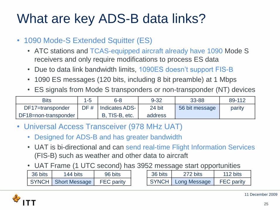
What are key ADS-B data links?
• 1090 Mode-S Extended Squitter (ES)
• ATC stations and TCAS-equipped aircraft already have 1090 Mode S
receivers and only require modifications to process ES data
• Due to data link bandwidth limits, 1090ES doesn’t support FIS-B
• 1090 ES messages (120 bits, including 8 bit preamble) at 1 Mbps
• ES signals from Mode S transponders or non-transponder (NT) devices
• Universal Access Transceiver (978 MHz UAT)
• Designed for ADS-B and has greater bandwidth
• UAT is bi-directional and can send real-time Flight Information Services
(FIS-B) such as weather and other data to aircraft
• UAT Frame (1 UTC second) has 3952 message start opportunities
25
36 bits 144 bits 96 bits
SYNCH Short Message FEC parity
36 bits 272 bits 112 bits
SYNCH Long Message FEC parity
Bits 1-5 6-8 9-32 33-88 89-112
DF17=transponder
DF18=non-transponder
DF # Indicates ADS-
B, TIS-B, etc.
24 bit
address
56 bit message parity
11 December 2009
UAT 978 & 1090ES spectrum –Both in the ARNS band (960-1215 MHz)
• 1090 Mhz center frequency dedicated to Secondary Surveillance
Radar (SSR), Traffic Alert and Collision Avoidance System
(TCAS), and Extended Squitter ADS-B systems
• SSR interrogation (1030 MHz) and reply (1090 MHz) channels
• Notches around 1090 MHz for Joint Tactical Information
Distribution System/Multifunction Information Distribution System
(JTIDS/MIDS) & Directional Measuring Equipment/Tactical Air
Navigation (DME/TACAN) ops
• By comparison, UAT 978 MHz spectrum less congested
261090 MHz in congested part of the spectrum

11 December 2009
Ambient Emissions in the 1010-1060 MHz Frequency Band at BWI Airport
27
MEASURED EMISSIONS DATA FOR USE IN EVALUATING THE ULTRA-WIDEBAND (UWB) EMISSIONS
LIMITS IN THE FREQUENCY BANDS USED BY THE GLOBAL POSITIONING SYSTEM (GPS)
Project TRB 02-02 Report, October 22, 2002, Technical Research Branch
Laboratory Division Office of Engineering and Technology Federal Communications Commission
IFF 1030 MHz
Peak
Ambient
11 December 2009
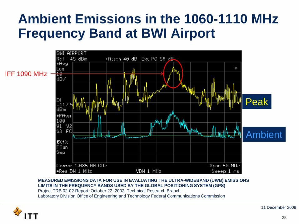
Ambient Emissions in the 1060-1110 MHz Frequency Band at BWI Airport
28
MEASURED EMISSIONS DATA FOR USE IN EVALUATING THE ULTRA-WIDEBAND (UWB) EMISSIONS
LIMITS IN THE FREQUENCY BANDS USED BY THE GLOBAL POSITIONING SYSTEM (GPS)
Project TRB 02-02 Report, October 22, 2002, Technical Research Branch
Laboratory Division Office of Engineering and Technology Federal Communications Commission
Peak
Ambient
IFF 1090 MHz
11 December 2009
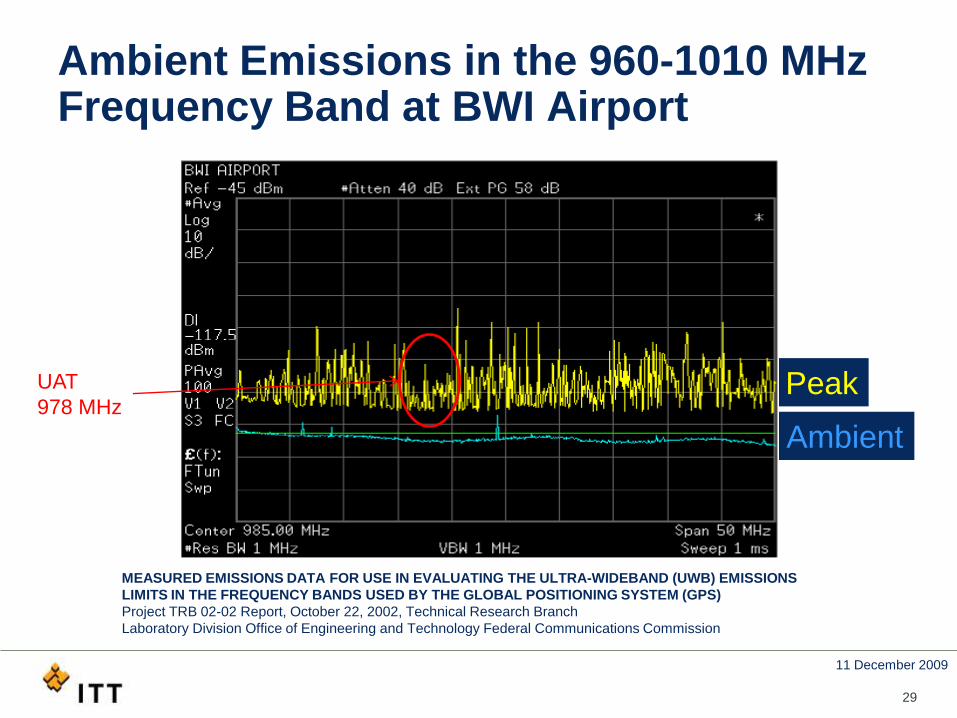
Ambient Emissions in the 960-1010 MHz Frequency Band at BWI Airport
29
MEASURED EMISSIONS DATA FOR USE IN EVALUATING THE ULTRA-WIDEBAND (UWB) EMISSIONS
LIMITS IN THE FREQUENCY BANDS USED BY THE GLOBAL POSITIONING SYSTEM (GPS)
Project TRB 02-02 Report, October 22, 2002, Technical Research Branch
Laboratory Division Office of Engineering and Technology Federal Communications Commission
Peak
Ambient
UAT
978 MHz
11 December 2009
30
ADS-B Ground Infrastructure
• ADS-B requires ground infrastructure to process & disseminate
• ADS-B reports to ATC facilities
• TIS-B and FIS-B messages
• Nationwide deployment ongoing
11 December 2009
31
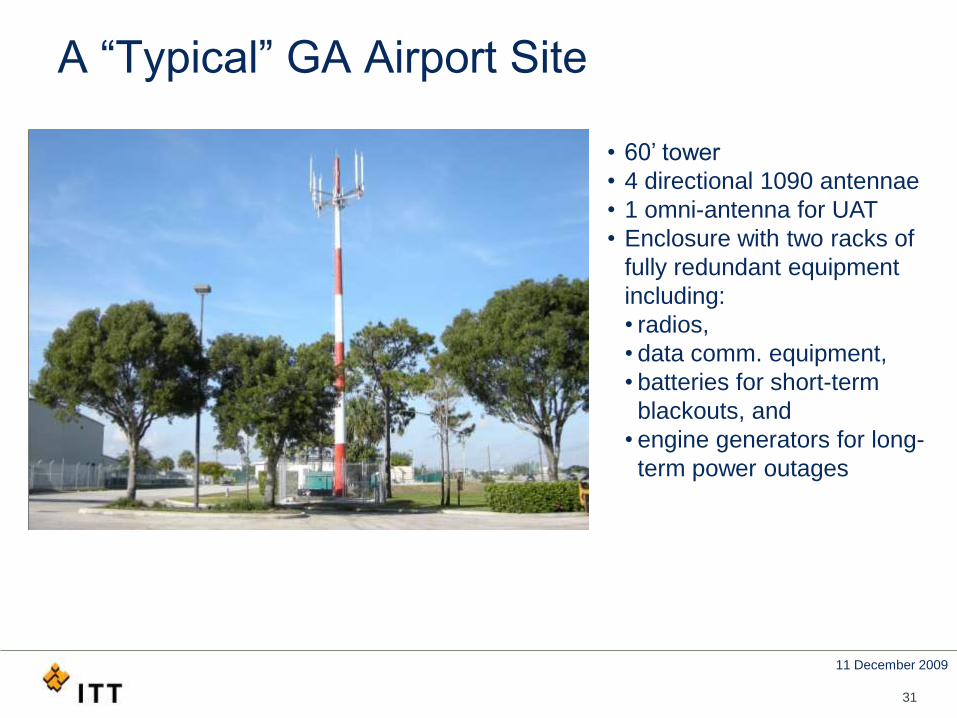
A “Typical” GA Airport Site
• 60’ tower
• 4 directional 1090 antennae
• 1 omni-antenna for UAT
• Enclosure with two racks of
fully redundant equipment
including:
• radios,
• data comm. equipment,
• batteries for short-term
blackouts, and
• engine generators for long-
term power outages
11 December 2009
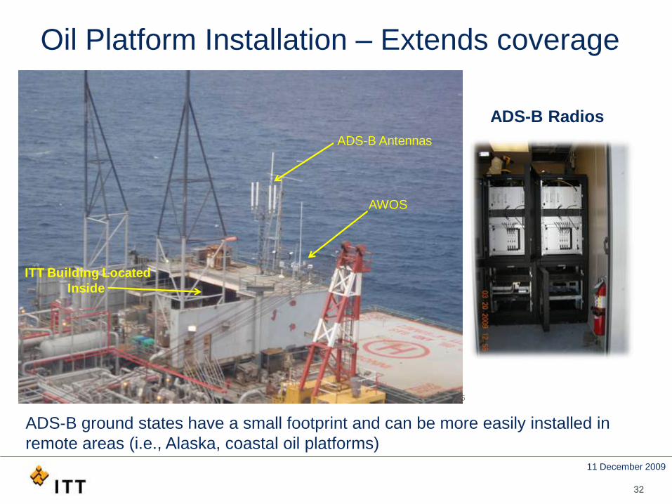
Oil Platform Installation – Extends coverage
32
Surveillance and Broadcast ServicesCopyright © 2009 ITT Corporation - use/disclosure of data is subject to restrictions on title page. 6
ITT Building Located
Inside
AWOS
ADS-B Antennas
ADS-B Radios
ADS-B ground states have a small footprint and can be more easily installed in
remote areas (i.e., Alaska, coastal oil platforms)
11 December 2009
33
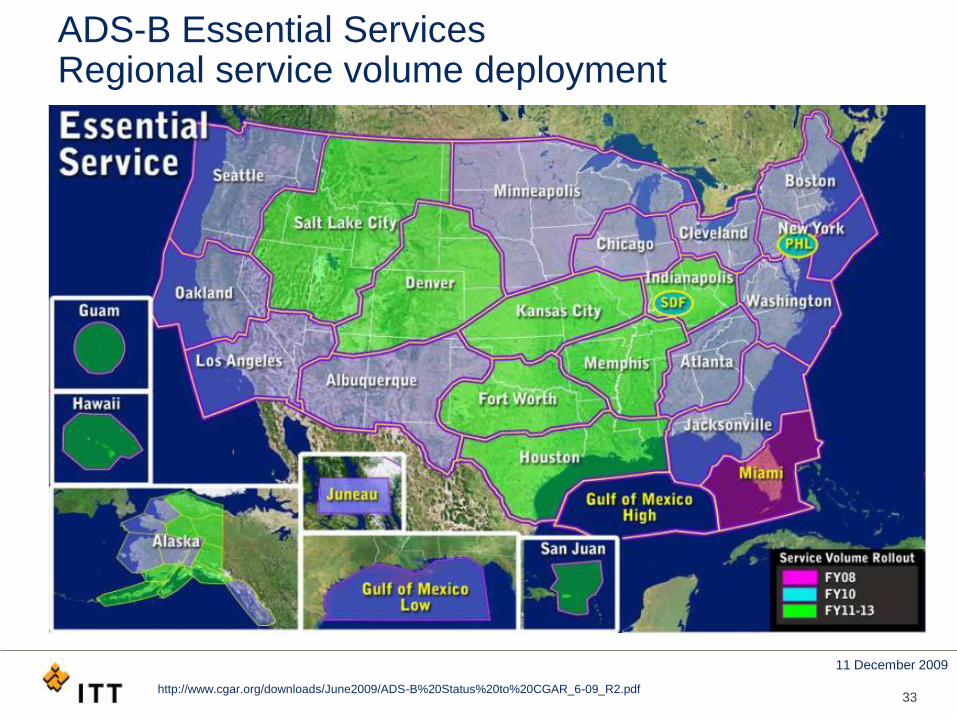
ADS-B Essential Services Regional service volume deployment
http://www.cgar.org/downloads/June2009/ADS-B%20Status%20to%20CGAR_6-09_R2.pdf
11 December 2009
34
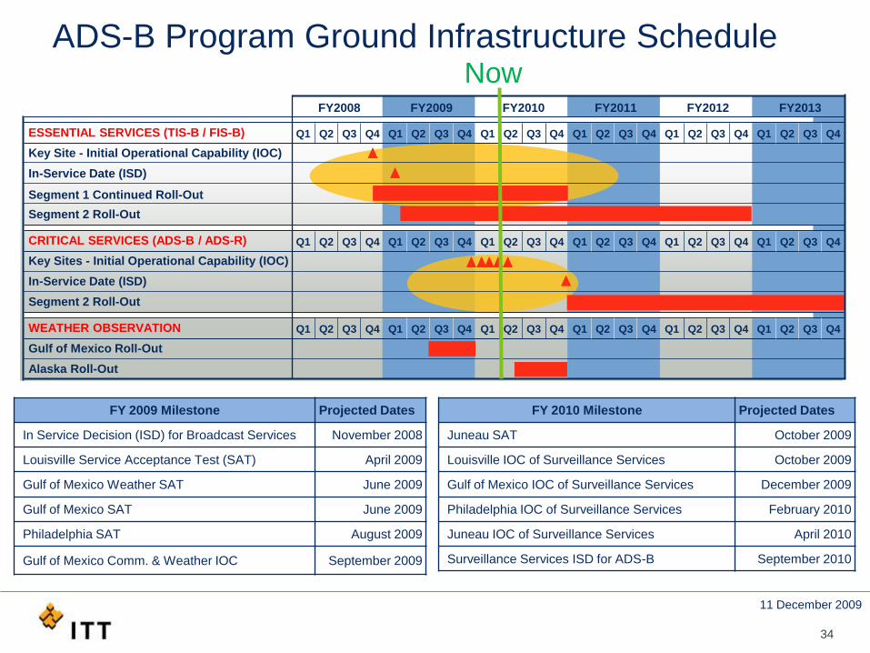
ADS-B Program Ground Infrastructure Schedule
ESSENTIAL SERVICES (TIS-B / FIS-B)
Key Site - Initial Operational Capability (IOC)
In-Service Date (ISD)
Segment 1 Continued Roll-Out
Segment 2 Roll-Out
CRITICAL SERVICES (ADS-B / ADS-R)
Key Sites - Initial Operational Capability (IOC)
In-Service Date (ISD)
Segment 2 Roll-Out
WEATHER OBSERVATION
Gulf of Mexico Roll-Out
Alaska Roll-Out
FY2012 FY2013FY2008 FY2009 FY2010 FY2011
Q1 Q2 Q3 Q4 Q1 Q2 Q3 Q4 Q1 Q2 Q3 Q4 Q1 Q2 Q3 Q4 Q1 Q2 Q3 Q4 Q1 Q2 Q3 Q4
Q1 Q2 Q3 Q4 Q1 Q2 Q3 Q4 Q1 Q2 Q3 Q4 Q1 Q2 Q3 Q4 Q1 Q2 Q3 Q4 Q1 Q2 Q3 Q4
Q1 Q2 Q3 Q4 Q1 Q2 Q3 Q4 Q1 Q2 Q3 Q4 Q1 Q2 Q3 Q4 Q1 Q2 Q3 Q4 Q1 Q2 Q3 Q4
Now
FY 2009 Milestone Projected Dates
In Service Decision (ISD) for Broadcast Services November 2008
Louisville Service Acceptance Test (SAT) April 2009
Gulf of Mexico Weather SAT June 2009
Gulf of Mexico SAT June 2009
Philadelphia SAT August 2009
Gulf of Mexico Comm. & Weather IOC September 2009
FY 2010 Milestone Projected Dates
Juneau SAT October 2009
Louisville IOC of Surveillance Services October 2009
Gulf of Mexico IOC of Surveillance Services December 2009
Philadelphia IOC of Surveillance Services February 2010
Juneau IOC of Surveillance Services April 2010
Surveillance Services ISD for ADS-B September 2010
11 December 2009
35
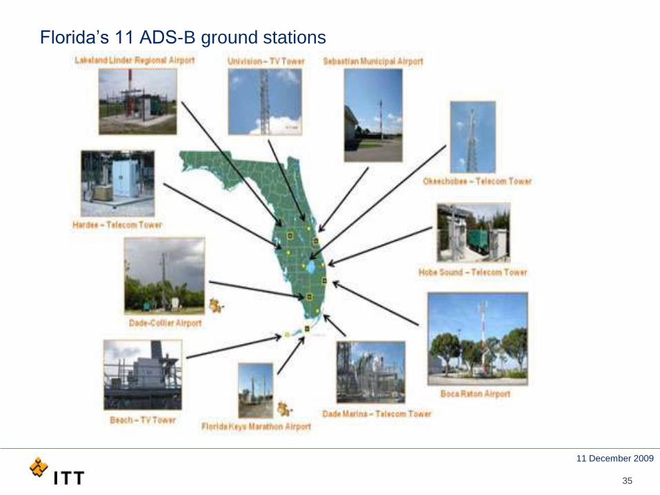
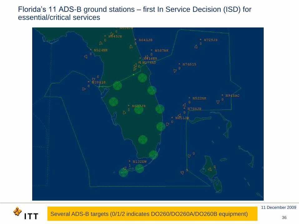
Florida’s 11 ADS-B ground stations
11 December 2009
36
Florida’s 11 ADS-B ground stations – first In Service Decision (ISD) for essential/critical services
Several ADS-B targets (0/1/2 indicates DO260/DO260A/DO260B equipment)
11 December 2009
37
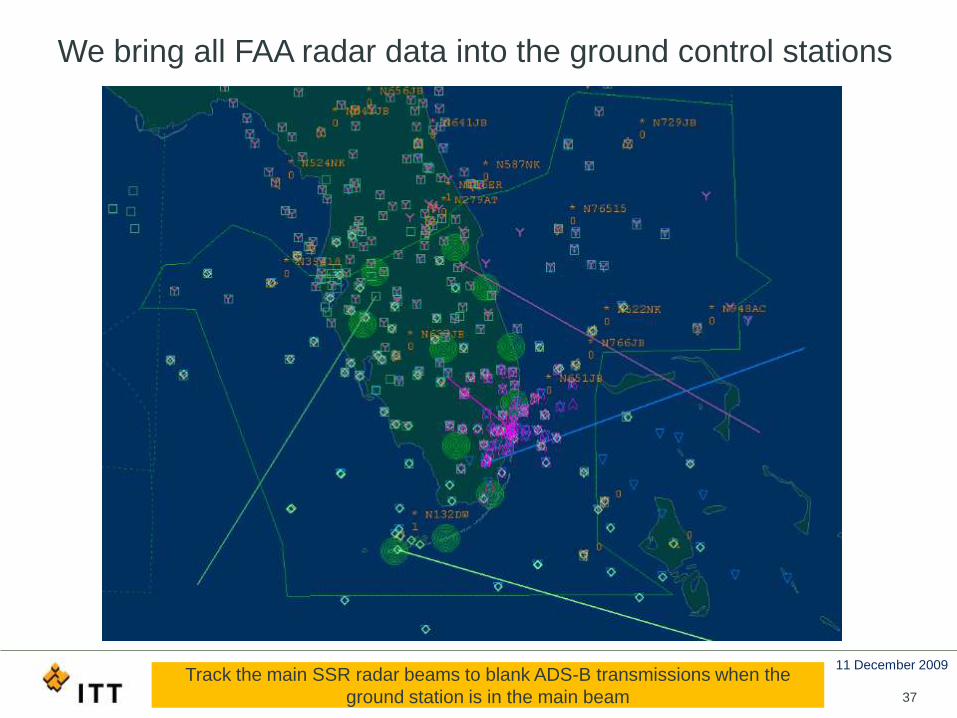
We bring all FAA radar data into the ground control stations
Track the main SSR radar beams to blank ADS-B transmissions when the
ground station is in the main beam
11 December 2009
38
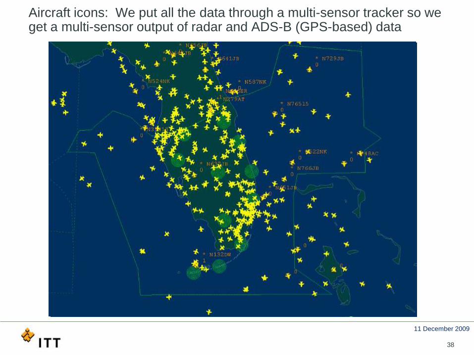
Aircraft icons: We put all the data through a multi-sensor tracker so we get a multi-sensor output of radar and ADS-B (GPS-based) data
11 December 2009
39
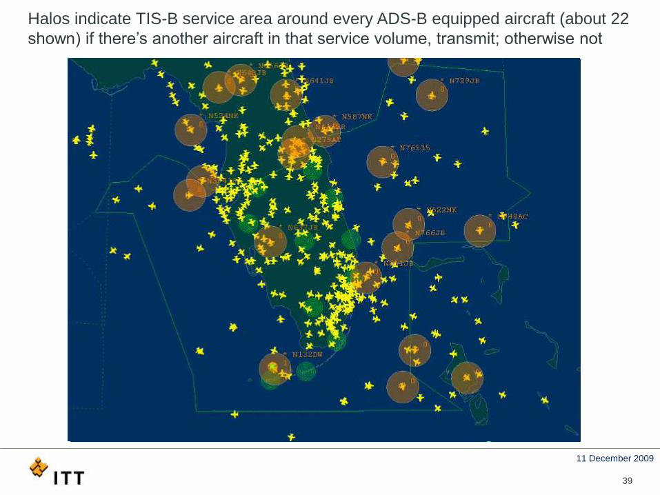
Halos indicate TIS-B service area around every ADS-B equipped aircraft (about 22
shown) if there’s another aircraft in that service volume, transmit; otherwise not
11 December 2009
41
Conclusion
• GPS/GNSS makes ADS-B possible
• ADS-B is safe, robust, scalable, and secure
• FAA deploying ADS-B infrastructure
• Essential services complete by 2012 & critical services by 2013
• Deploying ground infrastructure with system ops & maintenance
11 December 2009
42
BACKUPS
http://www.itt.com/adsb/
http://www.faa.gov/air_traffic/technology/ads-b/
http://www.rtca.org/
11 December 2009
43
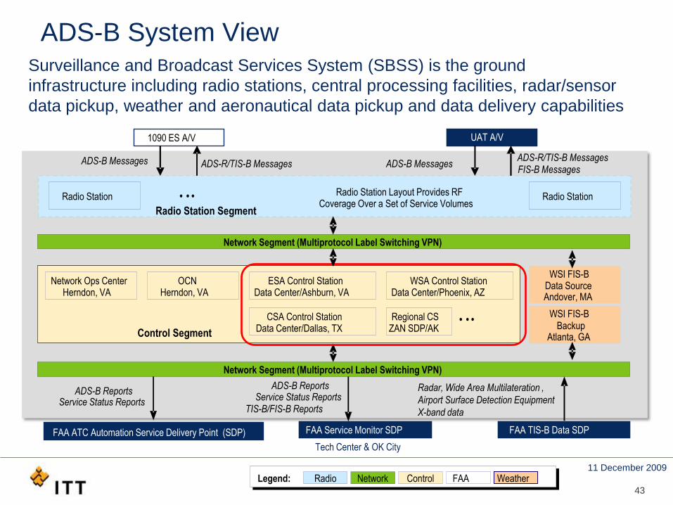
1090 ES A/V UAT A/V
ADS-B Messages ADS-R/TIS-B MessagesFIS-B Messages
ADS-B Messages
Radio Station Radio StationRadio Station Layout Provides RF Coverage Over a Set of Service Volumes
Radio Station Segment
• • •
Network Segment (Multiprotocol Label Switching VPN)
Legend: Radio Network Control FAA Weather
Network Ops CenterHerndon, VA
OCNHerndon, VA
ESA Control StationData Center/Ashburn, VA
WSA Control StationData Center/Phoenix, AZ
CSA Control StationData Center/Dallas, TX
WSI FIS-BData SourceAndover, MA
BackupAtlanta, GA
Network Segment (Multiprotocol Label Switching VPN)
ADS-B ReportsService Status Reports
ADS-B Reports
TIS-B/FIS-B Reports
Radar, Wide Area Multilateration ,
Airport Surface Detection Equipment
X-band data
FAA Service Monitor SDP FAA TIS-B Data SDP
Control Segment
WSI FIS-B
ADS-B System View
ADS-R/TIS-B Messages
Service Status Reports
Tech Center & OK City
Regional CSZAN SDP/AK
• • •
Surveillance and Broadcast Services System (SBSS) is the ground
infrastructure including radio stations, central processing facilities, radar/sensor
data pickup, weather and aeronautical data pickup and data delivery capabilities
FAA ATC Automation Service Delivery Point (SDP)
11 December 2009
44
What is ADS-B IN & ADS-B OUT?
• ADS-B IN – aircraft receives ADS-B info for Cockpit Display of
Traffic Information (CDTI) such as “see and avoid” surveillance
or flight information such as weather
• FAA will define strategy for ADS–B IN by 2012
• ADS-B OUT – aircraft transmits its navigation state vector for
Air Traffic Control surveillance
• The Aviation Rulemaking Committee (ARC) supports ADS-B OUT
implementation in the NAS by 2020
• ADS-B OUT aircraft-based 1090ES equipment may eventually
replace radar surveillance technology